Report. Environmental Water Demands. Butte County Department of Water and Resource Conservation Integrated Water Resources Plan.
|
|
|
- Anna Barber
- 5 years ago
- Views:
Transcription
1 Report Butte County Department of Water and Resource Conservation Integrated Water Resources Plan s June 2004
2 s Section 1 - Introduction 1.1 Project Description This project is a preliminary investigation of environmental water use and demand in Butte County. Calculating current environmental demand and projecting future demands requires knowledge of current habitats, demands by habitat type, instream flow requirements, and groundwater-surface water interactions for areas with shallow groundwater. Some of this information is not yet available; therefore, rigorous demand calculations are not currently possible. More data needs to be collected on stream and ground water interactions in Butte County and the associated biological activities occurring within the rooting zone. The dynamic processes occurring between ground water and atmospheric conditions are also not well understood. This report does not consider all facets of the water use in the environment. For instance the amount of water used in vernal pool habitats was not addressed because there is no existing data that attempts to quantify the amount of water necessary to provide a vernal pool habitat. 1.2 Purpose and Scope Purpose: Make the first approximation of overall environmental water demands, and identify future needs in evaluation of environmental water demands and links to the Environmental Monitoring Program. Scope: The scope of this project is to provide a first approximation of the environmental water use and demand in Butte County. The scale of this project is a big picture of the environmental water demand in Butte County. The project is limited to existing data resources. 1.3 Background The quality of life for Butte County residents is determined by environmental conditions. The Butte County Department of Water and Resource Conservation (DW&RC) is concerned with conserving water and other resources for all the citizens of Butte County to help ensure the quality of life is maintained. The demand for water resources is becoming more immediate. Quantifying the amount of environmental water consumed in Butte County will help protect the natural resources and the quality of life in Butte County. Section 2 Water Balance Approach A water balance is a practical method of evaluating the physical processes associated with water resources and management practices. Generally, a water balance is constructed for an unaltered watershed; however, in Butte County, there are no unaltered watersheds. The objective of creating this water balance is to evaluate the 1
3 existing data and create a first approximation of environmental water use based on the best available data. Using the water balance approach to assess water resources becomes more complicated when altered landscapes are present. For instance, water that is diverted into Butte Creek from the West Branch of the Feather River changes the amount of flow in Butte Creek and the Feather River without regard to natural physical process such as precipitation. The water balance approach therefore becomes a matter of physical, biological and management processes which is more complicated than simply addressing the natural processes in a landscape setting. This is important because the water balance is an equation that sets all incoming water to outgoing water resources. The water balance approach assumes that the total incoming water is precipitation and groundwater flow is not a contributing factor. The only watershed completely within the boundaries of Butte County is Little Chico Creek. It is logical to assume that creek flow, groundwater flow and precipitation from outside the Butte County boundaries are contributing sources of water to the resources in Butte County. However, for the purposes of this first approximation of environmental water use, it is assumed that precipitation falling on Butte County is the amount of incoming water into Butte County. For practical purposes water use is divided into three categories: urban, agricultural, and environmental. Urban water use occurs in any urban setting, including household, commercial and industrial uses. Agricultural water use is mainly crop irrigation. Environmental water use is for managed conservation and restoration areas and any water utilized by the environment. The physical and biological processes that govern the amount of environmental water use in the hydrologic cycle are dynamic. The major components of environmental water use are evapotranspiration, evaporation, ground water recharge, soil moisture content, stream groundwater interactions, groundwater flow, runoff and streamflow. The water balance is like capturing a snapshot of the water resources in Butte County It is created from existing data resources and is an attempt to piece together the picture that best explains how much environmental water use is occurring in Butte County in an average year. A water balance is constructed based on a simple equation that equates incoming versus outgoing volumes of water. In the most simplified version of the equation the amount of incoming water is the total volume of precipitation (ppt). The amount of incoming ppt is set equal to outgoing water that includes evapotranspiration (ET), runoff (ro), streamflow (sf) in creeks and change to groundwater (gw) storage. Ppt = et + ro + sf + change in gw storage The water balance approach assumes a geologically confined area (i.e., no ground water is entering the system). Also, the water balance approach assumes that the area of concern completely encompasses whole watersheds. Unfortunately when State, county and private property lines are created they are not defined by natural boundaries such as watershed divides. Butte County shares watersheds will all 2
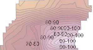
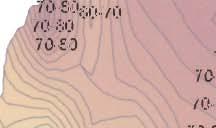
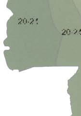
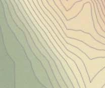
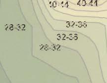
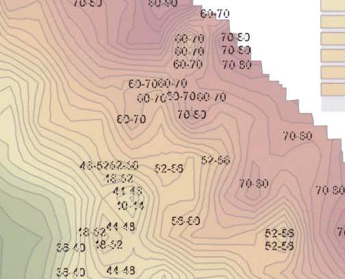
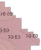
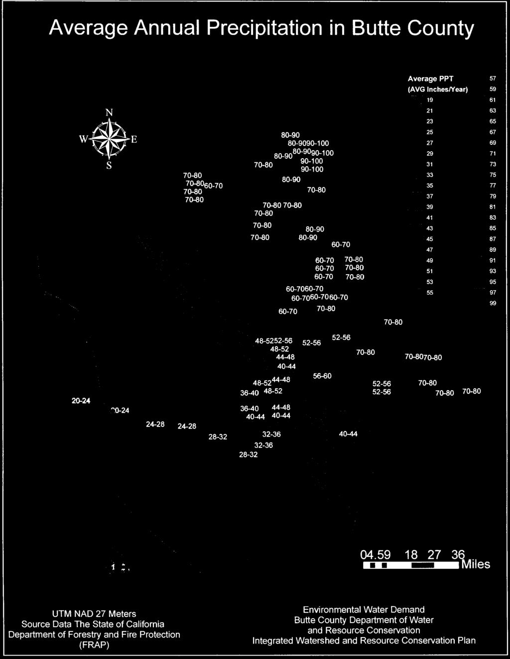
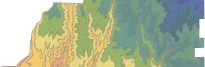
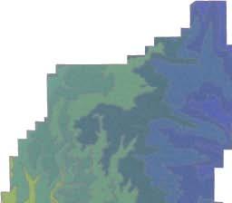
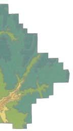
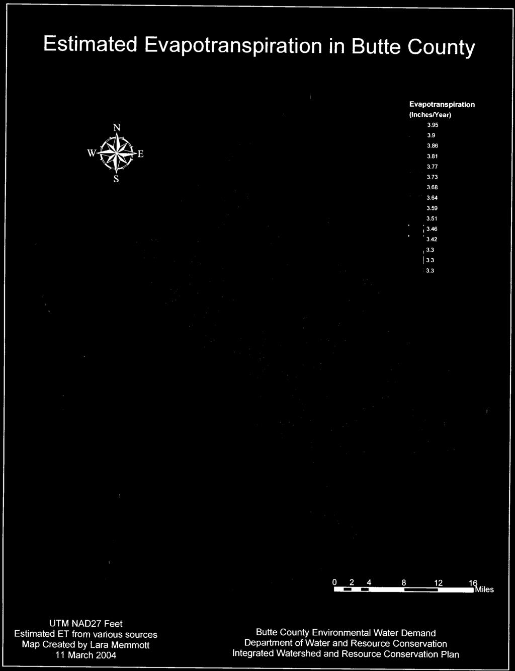
4 adjoining counties. There is some water that enters Butte County through groundwater flow and through streamflow. Stream gages placed at the county boundary and additional groundwater monitoring wells would improve the knowledge of water entering Butte County through groundwater flow and streamflow. For the purpose of this exercise, the amount of incoming water considered is from precipitation. The equation shown below is the first attempt to apply the water balance approach to estimating the environmental water use in Butte County. All values shown are in acre feet per year. The following sections describe how each of the values were calculated for the water balance. The value calculated for runoff was arrived at by deducting the amount of precipitation not going to evapotranspiration or base flow in streams assuming that there is no change in groundwater storage in a normal year. Ppt = ET + ro + sf + change in gw storage 4,000,000 = 3,400, , , Precipitation The amount of annual average precipitation was calculated using the isohyetal method (see attached map Average Annual Precipitation in Butte County). The isohyets are available from the GIS downloadable data from the California Data Exchange Center. The number of acres multiplied by the average precipitation was totaled for Butte County. There are 4,000,000 acre feet of precipitation in an average (normal) year falling on Butte County. The total number of acres within each isohyet zone was multiplied by the average amount of rainfall in that zone and totaled to approximately 4,000,000 acre feet per year. 2.2 Evapotranspiration Evapotranspiration was estimated from average annual lake evaporation map created by Kohler and others (1959) for the years Better methods of calculating ET and additional data collection will help create a more accurate estimation of ET. The following data in Table 1 shows the ET in feet per year correlated with elevation. The information was used to make the map of ET (see attached map Estimated ET in Butte County). The evapotranspiration zones were totaled for acreage and then multiplied to approximate total ET in Butte County at 3,400,000 acre feet per year. There are many ways of calculating ET and there are remote sensing applications that may help improve the estimation of ET. Additional data may also help improve the approximation of ET. 3
5 2.3 Runoff Table 1 ET vs Elevation Elevation change ET Rate (Feet/Year) ET total (Acre Feet/Year) Less than 500 ft ft. to 1000 ft ft. to 1500 ft ft. to 2000 ft ft. to 2500 ft ft. to 3000 ft ft. to 3500 ft ft. to 4000 ft ft. to 4500 ft ft. to 5000 ft ft. to 5500 ft ft. to 6000 ft ft. to 6500 ft ft. to 7000 ft ft. to 7500 ft Total 3,443, Runoff was calculated by subtracting evapotranspiration and baseflow. As water runs off a landscape there are surficial processes that drive its direction. The water may be utilized by plants or in the soil as it moves downhill or possibly into a stream, the subsurface zone or ground water. The character of the ground surface and associated vegetation will be the factors that define the movement of water. More confined geologic formations that form shallow soils not disrupted by faults, fractures and joints will move water across the surface more quickly than deep soils surfaces with thick vegetative cover or areas that are faulted, fractured and have jointed geologic controls over groundwater flow paths. The Chico Monocline is the active fault zone in Butte County that runs along the foothill zone. The Chico Monocline is exhibited clearly through the more consolidated units of the Tuscan Formation that quickly shed water, but the amount of water that may be running off these landscapes and into groundwater is not well understood. The active tectonics of the Chico Monocline may play a role in the groundwater resources of Butte County. A potential theory is that the faults, fractures and joints in the Tuscan Formation caused by the Chico Monocline s activity could influence the direction of groundwater flow. Further studies about the groundwater resources in Butte County will provide insight into the surficial processes that govern flow of water across the landscapes in Butte County. 2.4 Change in groundwater storage For the purpose of creating this water balance it is assumed that groundwater storage does not change. The DW&RC has coordinated efforts with California Department of 4
6 Water Resource on a continuing basis to monitor groundwater levels in well throughout Butte County. In the future, a detailed map of hydrogeology of Butte County will assist in evaluating the changes in groundwater storage. Changes in groundwater storage also need to be evaluated through stream groundwater interactions. Stream groundwater interactions are an important aspect of the hydrogeology in Butte County. By promoting research and monitoring to understand the physical processes occurring in stream groundwater interactions we may apply adaptive management strategies to more effectively manage our water resources. Changes to groundwater storage are caused by naturally occurring events such as the seasons or human use. Seasonal fluctuations in temperature, wind and daylight hours cause soil moisture to fluctuate and living organisms to change their behavior causing changes to use in the surrounding environment. Seasonal changes are also followed by the changing agricultural practices. Groundwater is used for irrigation as well as frost protection when the cool temperatures of spring threaten orchard crops of freezing. The Water Inventory and Analysis identified 439,000 acre feet of water in a normal year is used from ground water resources. This amount changes corresponding to the climate of the year; more water may be pumped in a dry year. 2.5 Change in surface water storage Changes in surface water storage fluctuate seasonally and based on management strategies. In the upper watersheds of Butte Creek and the Feather River hydroelectric power production is managed based on electric demand of the consumer. Downstream into the Sacramento River Valley, surface water storage changes depend more on agricultural and urban demands. Wetland management strategies fluctuate and also cause change in surface water storage. Agricultural, urban and environmental demand cause changes to the amount of surface water storage in Butte County and affect the surrounding environment. Managed wetlands, for instance use 9,000 acre feet of water on 6,000 acres of land in Butte County. Lake Oroville (SWP) and other features such as Thermalito Afterbay and other reservoirs in Butte County are seasonally filled and drained. The result is a change in the amount of aquatic and riparian habitat and a change in amount of water that alters the physical processes of the hydrologic cycle. For example, if more water in a reservoir is available to the incoming solar radiation, the more ET is likely to occur given the right conditions. The components of the physical processes particular to the surface water storage facilities in Butte County are not fully documented. When reservoirs are filled and emptied the interactions with the canals and streams with surrounding groundwater and organisms is not well understood. How the effects of surface water storage alter the hydrologic cycle of water in Butte County is an important aspect of water resource management. Evaluation of the interactions between these management strategies 5
7 and surround environments will be a useful tool to create a more efficient scheme of water management strategies. 2.6 Surface Water Flows CDEC provides flow data from creeks and rivers in Butte County. Estimated average annual flow in Big Chico Creek, Butte Creek and Feather River were approximated from historical data. The following Table 2 shows the values approximated from available data. Table 2 Stream Base Flows Average Annual Acre Feet of Flow Big Chico Creek Butte Creek Feather River Total Additional flow gages to assist the process of creating a more accurate water balance for Butte County will be helpful in quantitatively assessing flow in streams. All of the creeks in Butte County are affected by activities occurring with the management of water resources. Agricultural, aesthetic, hydroelectric power production, flood control, storm drain runoff and other activities result in multiple changes to creek flows. In addition, the effects of groundwater pumping and alterations of natural flow regimes on stream ecosystems and the amount of stream flow needs to be addressed. Section 3 in Conservation Managed Landscapes 3.1 Managed Habitat In addition to approximating a rough water balance for environmental water demands, a number of specific situations were also evaluated. There are State, federal, city and private landowner local organizations that manage land and water for environmental purposes. These lands serve many purposes including recreation, aesthetic, educational, environmental and overall health for the citizens of Butte County. Some of the more popular locations are the Upper Butte Basin Wildlife Area, Gray Lodge and Bidwell Park. 6
8 The source, distribution and immediate purpose of water used in restoration and conservation efforts in Butte County varies by type of activity and by habitat type. For instance in the channel restoration of Big Chico Creek, Stream Minders used water from Big Chico Creek to irrigate stream bank vegetation that was planted. Some restoration calls for water to be brought in by tank and managed wetlands use flooding to provide waterfowl habitat. The amount of water used on the 6,000 acres of public lands managed for wetland habitat in Butte County is 9,000 acre feet per year. The following short paragraphs are included as examples of the diverse management activities that take place in Butte County that are geared towards improving environmental conditions. This a snapshot of the big picture regarding water used for restoration and conservation efforts in Butte County. The information provided here is not a quantitative measure of all of the efforts that take place in Butte County. 3.2 Sacramento River Partners The Llano Seco Ranch lies in the western portion of Butte County and bounded on the west by the Sacramento River and on the east by Seven Mile Lane. The Sacramento River Partners contracted an Oak Woodland/Savanna Restoration Project through the Fish and Wildlife Service on 260 acres of land on the Llano Seco Ranch. There were 4,000 plants on 72 acres (Tract 1) that had a 98 percent survival rate that were in sandy loam soils. There were 8000 plants on 188 acres (Tract 4) that had a 49 percent survival rate that were in smectitic clay (shrink/swell) soils. The plants were in low density clusters and tank irrigated with about 8 acre feet of water. Acres Land Type Water Used /Method of Dispersal 7.95 Acre Feet / 1000 gallon Tank Irrigation Source Water Length of Water Use 260 Oak Woodland Savanna Angel Slough Irrigation Ditch 3 Years 3.3 California Department of Fish and Game The Upper Butte Basin Wildlife Area has two management areas in Butte County, the Llano Seco Unit and the Little Dry Creek Unit. The Llano Seco Unit is 1516 acres, of which 60 percent is wetland habitat. This area also has riparian and upland habitat. There is 4,000 acre feet of water per year used on Llano Seco Unit. The Little Dry Creek Unit is 4,000 acres, of which 75 percent is wetlands. There is 7 to 85 acre feet per year used on this unit. The management activities that cause water use to vary are the development projects that are in initial stages. The Fish and Game will not use any water during construction then will provide enough water for riparian plants to become established before diminishing flows for the following two years. These lands are managed for 13 species of federally or State listed species and 50 species of special concern. 7
9 Acres Land Type Water Used /Method Source Water Length of Water Use of Dispersal 1,516 wetland/ upland/ 4,000 acre feet Annually riparian 4,000 w/u/r 7-85 acre feet Annually 3.4 U.S. Fish and Wildlife Service Acres Land Type Water Used /Method of Dispersal 760 wetland 5,100 Acre Feet /M&T Pumping Station Source Water Sacramento River Length of Water Use Annually 3.5 Natural Resource Conservation Service Private landowners may participate in federally funded conservation efforts through the Resource Conservation District. The water use information regarding these conservations efforts is not available and so was not incorporated into this evaluation. 3.6 Stream Minders There are currently 6 projects on 4 sites in Bidwell Park. Amount of water varies dependent on length of irrigation period needed for replanting efforts. When plants become established the irrigation period is terminated so site specific conditions apply to these restoration efforts. 3.7 Private Landowners Private landowners include individuals that may have conservation easements through habitat conservation groups, federal or local agencies to provide habitat on their property. Some private landowners may not have conservation easements, but a genuine commitment to providing habitat on their personal property. Private duck hunting clubs are an excellent example of this situation. Other specific data regarding environmental water use on private lands is difficult to assess because it is private information that is not made public by agencies and organizations that may be funding some of the costs of land management practices that provide habitat for environmental needs. Section 4 In-stream flow requirements The Feather River and Butte Creek currently have instream flow requirements in Butte County. Instream flow requirements are flexible to changing regulations and data availability. For example, the Calfed Environmental Water Program is currently evaluating the flow requirements for fish on Butte Creek. Instream flow requirements 8
10 are difficult to convert to volumetric amounts of water because the regulations are not always implemented for the entire year. Also, 40 cfs flowing in one portion of the creek may not equate to the same cfs downstream or upstream because of stream groundwater interactions. In the water balance, baseflow in Big Chico Creek, Butte Creek and the Feather River were used because there are flow gages on these creeks. However, these flows may not accurately represent the flow upstream or downstream of the gage. It is also important to remember that these flows were estimated for the purpose of capturing a glimpse of the amount of water used by the environment. Section 5 Results A more comprehensive and quantitative water balance will be created when more data is acquired by the DW&RC. Additional data also will need to be gathered in order to learn more about the physical processes that are altered with changing water resource management strategies. Stream gages are an important data source in Butte County. Stream gages provide quantitative methods of creating a water balance and a more thorough understanding of water resources in Butte County. Stream groundwater interactions can be studied through setting a network of piezometers (shallow ground water monitoring wells) associated with the installation of stream gages. Stream groundwater interactions are an important physical process associated with ground water recharge. The change in ground water storage will be more fully understood by implementing a stream groundwater interaction monitoring plan. Critical areas such as recharge zones need to be more accurately identified and monitored. The effect of surface water storage on ground water is another aspect of the water balance approach that needs to be evaluated. Reservoir ground water interactions and lake level interactions with ground water are important to understanding how management of this water affects the surrounding environment and other water resources. Also, a network of soil temperature data will help understand the physical environment better. Soil temperature data and stream temperature data collected in conjunction with stream ground water interaction monitoring and reservoir and lake level data will be incorporated into the hydrologic cycle and will further our understanding how one management strategy may affect water resources. The water balance approach to understanding a simplified yet comprehensive picture of the hydrology of Butte County is useful as long as assumptions can be accepted. The water balance approach to understanding the physical processes of the hydrologic cycle of water in Butte County can be improved by gathering additional data and analyzing the data with better methods. The water balance method can be a tool tailored for seasonal conditions so that at any point in time it s relatively easy to evaluate the current conditions and compare those to normal years. Also, it can be a tool to evaluate where increased water usage in one sector may affect the water resource in another. For instance if the amount of water utilized from ground water resource how does that affect the flow in streams. Another application for the water 9
11 balance approach to evaluating water resources is to compare how projected values for urban, agricultural and environmental water demands play into actual water use over time. All of the data associated with creating a water balance in a GIS and incorporated into the data clearinghouse will be a useful tool for evaluating management strategies that most appropriately necessary for the need. If a water shortage in one area of Butte County occurs then options to solve that problem may be more easily available by analyzing the water balance data. Quantifying the total amount of water in any watershed at any given time is a difficult task. Additional data would improve the accuracy and further the understanding of the hydrologic functions in Butte County. The Environmental Monitoring Program suggests a water monitoring data clearinghouse through the Butte County s Integrated Water Resources Plan. This data will promote the understanding of water resources and improve modeling efforts. 10

12

13