Lesson learned from assessment (and monitoring) of transboundary aquifers
|
|
|
- Hilda Briggs
- 5 years ago
- Views:
Transcription


1 Lesson learned from assessment (and monitoring) of transboundary aquifers


2 What is an (Transboundary) Aquifer? Aquifer means a permeable waterbearing underground geological formation underlain by a less permeable layer and the water contained in the saturated zone of the formation. Transboundary aquifer or transboundary aquifer system means, respectively, an aquifer or aquifer system, parts of which are situated in different States;


3 Why do we need TBA Assessment? Most of the aquifers cross national borders Potential cross-boundary problems regarding changes of groundwater quality and quantity but also a platform for cooperation Differences among countries: languages, classifications and reference systems, policy, legal and institutional structure Joint assessment, monitoring and management required to improve collaboration, mitigate or eliminate potential problems and increase the overall benefit from groundwater


4 Global Progress of TBA Assessment

5

 framework adopted by the EEA a clear regional overview of current")
6 What have we learned so far? The UNECE Inventory 1999 Lesson learned: challenges of TBA and harmonisation Added value: pioneering role; formulating TBA characteristics; pan European overview The first UNECE Assessment 2007 followed the Driving Forces-Pressures-State-Impact -Responses (DPSIR) framework adopted by the EEA a clear regional overview of current groundwater status (including the TBA impact and mng. measures) of pressures and of future trends and prospects.


7 What have we learned so far? The second UNECE Assessment 2011, improved delineation, however: groundwater remains insufficiently addressed in IWRM GWB concept introduced in WFD, causing a harmonisation difficulty; the assessment remains politically very sensitive gw data difficult to obtain
")
, NW Sahara,")
 allowing")


8 What have we learned so far? Global Environment Facility (GEF) projects: Nubian, Guarani, SADC (Limpopo Basin), NW Sahara, Iullemenden, DIKTAS Mostly concentrate on one aquifer (system) allowing in-depth analysis: TDA-Transboundary Diagnostic Analysis Multidisciplinary Methodology: Hydrogeological Aspects, Environmental aspect, Socio-economical aspect and Legal & institutional aspect

")

9 More than an In-Depth Assessment GEF project main activities, three task approach: Improving state of knowledge (TDA) Establishing/improving cooperation mechanisms Facilitating harmonisation & priority reforms (SAP)


![density [cap/km 2 ]](/docs-images/94/121816566/images/10-11.jpg "Natural background")
10 Assessment Triggers an Action TWAP global baseline assessment is using comparative, indicator based methodology. Leads to rapid conclusions and suggests actions, such as.. Population density [cap/km 2 ] Natural background quality [% of surface area with good quality]


11 Also learned from GEF Assessments.. Methodology for TBA Assessment an indicator based assessment, enables comparison among aquifers at the regional or global scale and provides guidance when setting priorities an in-depth assessment for individual aquifers provides the information needed to define specific interventions for that aquifer. the same types of data are used on both levels Participatory approach unlocked groundwater data from national level and triggered cooperation between countries - ownership issue Structured & publically accessible database on transboundary aquifers continuity issue

12 TBA Outcomes Structured and Accessible TBA Briefs include: Basic geographical and hydrogeological info Location map with delineation Cross-section (if available) Table with core indicators Narratives of Aquifer geometry Hydrogeological aspects, Linkages with other water systems, Environmental aspects, Socio-economic aspects, Legal and Institutional aspects, Priority issues and Hotspots Contributors (national experts) Colophon, incl. reference


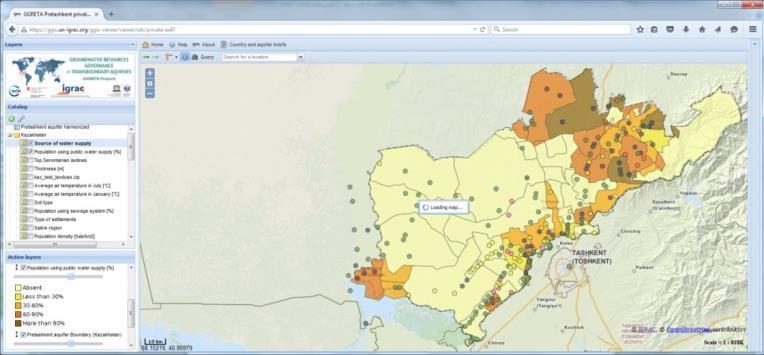
13 At the Global - Regional Level


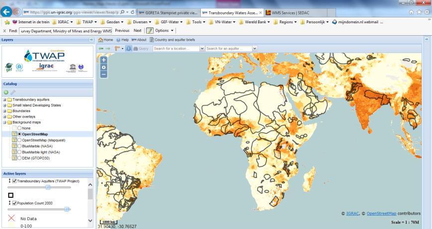
14 At the In-Depth (Aquifer) Level..


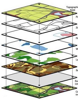


15 to be Used and Augmented Generate new information by making overlays of thematic maps Use of WMS - Web Mapping Service Analyze data by using filters / queries

16 Main Conclusions Connect/harmonise the assessment with other national/regional programmes and policy development, to increase prospects for implementation and follow up. A multi-disciplinary methodology provides a systematic approach for the assessment of transboundary aquifers at various levels of detail (and the basis for further cooperation!) Three tasks approach (fact finding, collaboration mechanism and joint action program) is logical and effective; Interactive Information Management System is a necessary enabling environment for international cooperation (and supports its sustainability) People networks are crucial, participatory approach, confidence building, clear agreements

17 ...it s all about people and connecting them


18 Thank you for your attention Delft, The Netherlands World Meteorological Organization Government of The Netherlands