APPLICANT: Pinnacle Land Development, L.L.C., Attn: Mr. Steve Gower, Lake Bluff Dr., St. Louis, Missouri
|
|
|
- Dwight Warner
- 5 years ago
- Views:
Transcription
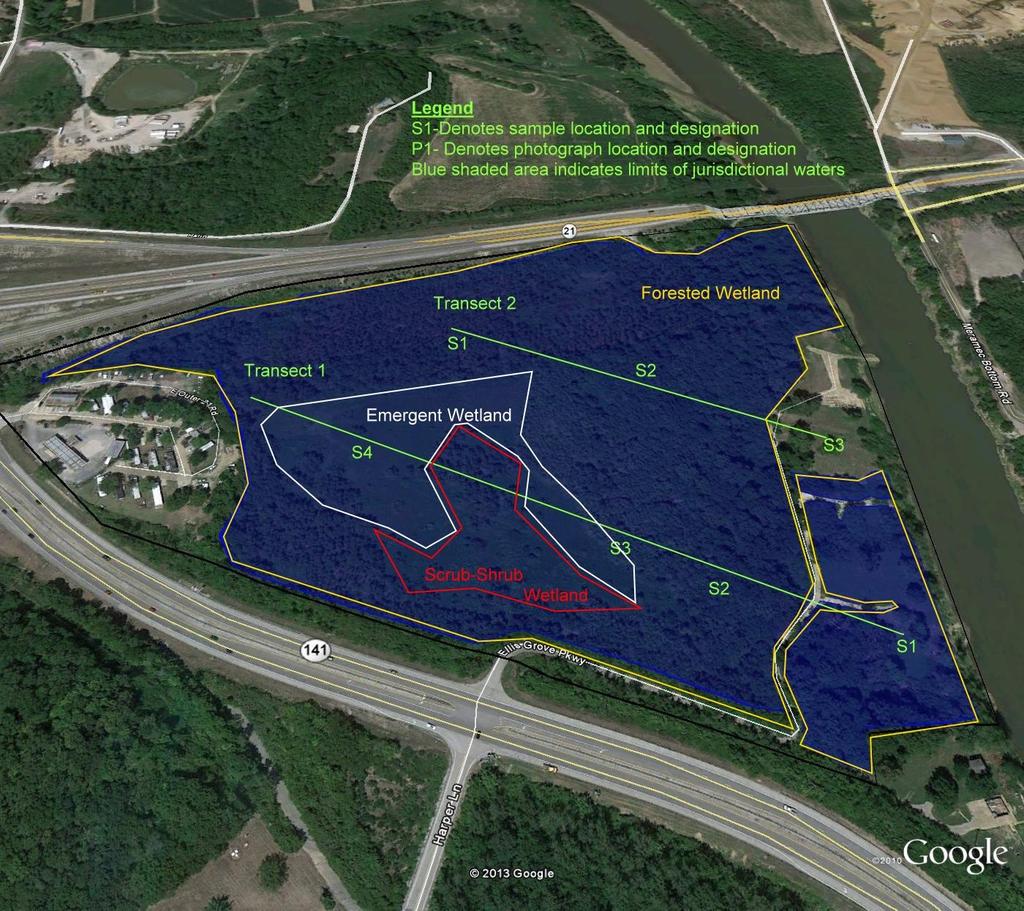
1 US ARMY CORPS Reply To: Public Notice No. OF ENGINEERS U.S. Army Corps of Engineers P-2855 St. Louis District Attn: CEMVS-OD-F Public Notice Date Gateway to Excellence 1222 Spruce Street December 12, 2013 St. Louis, Missouri Expiration Date Postmaster Please Post Conspicuously Until: January 10, 2014 File Number: Interested parties are hereby notified that an application has been received for a Department of the Army permit for certain work in waters of the United States, as described below and shown on the attached maps. COMMENTS AND ADDITIONAL INFORMATION: Comments on the described work should reference the U.S. Army Corps of Engineers File Number shown above and must reach this office no later than the above expiration date of the Public Notice to become part of the record and be considered in the decision. Comments should be mailed to the following address: U.S. Army Corps of Engineers Regulatory Branch 1222 Spruce Street St. Louis, Missouri ATTN: Shawn Sullivan APPLICANT: Pinnacle Land Development, L.L.C., Attn: Mr. Steve Gower, Lake Bluff Dr., St. Louis, Missouri ( ) AGENT: On-Site Soils, Inc., Attn: Mr. Matt Roth, 4077 St. Peters Parkway, Suite A, St. Peters, Missouri LOCATION: The project area is located between Highway 141, Highway 21 and the Meramec River in unincorporated Jefferson County, Missouri. More specifically, the project area can be identified on the Maxville 7.5 Minute USGS Topographic Quadrangle Map and is part of public land survey Section 13, Township 43 North, Range 5 East and has coordinate value of latitude and longitude The property is currently split zoned by Jefferson County as Non-Planned Community Commercial (CC2) and single family residential (R40). The project area is depicted on an attached location map. PROJECT DESCRIPTION: The applicant seeks authorization to conduct grading and filling activities in waters of the United States to develop the project area into a multi-use retail/commercial development. The applicant proposes to obtain offsite sources of fill material and raise the site to an elevation that is above the 100-year floodplain of the Meramec River and is accessible from U.S. Highway 141. The applicant proposes to clear, grub, and fill approximately acres of wetland identified on the property (see attached wetland delineation and development plan). The wetland types to be impacted include approximately 3.66 acres of emergent wetland, 2.60 acres of scrub-shrub wetland and 9.21 acres of forested wetland. The wetlands are situated adjacent to and/or abutting the Meramec River which is a navigable water and subject to Section 10 of the Rivers and Harbors Act of 1899 [33 U.S.C. 403]..
2 The applicant states there are no equivalent locations available within the project vicinity which meet the parcel size and price to accommodate this proposed multi-use retail/commercial development. A detailed alternatives analysis is required of the applicant. Also to comply with the requirements of 40 CFR Part 230 and 33 CFR 332, Compensatory Mitigation for Losses of Aquatic Resources; Final Rule the applicant proposes to offset unavoidable wetland impacts by providing compensatory wetland mitigation in the watershed at a mitigation bank and/or a permittee-responsible mitigation site. LOCATION MAPS AND DRAWINGS: See Attached ADDITIONAL INFORMATION: Additional information may be obtained by contacting Shawn Sullivan, Project Manager, U.S. Army Corps of Engineers, at (314) Your inquiries may also be sent by electronic facsimile to (314) or by to shawn.f.sullivan@usace.army.mil AUTHORITY: This permit will be processed under Section 404 of the Clean Water Act (33 U.S.C. 1344). WATER QUALITY CERTIFICATION: The project plans have been submitted to the Missouri Department of Natural Resources, Water Protection Program for state certification of the proposed work in accordance with Section 401 of the Clean Water Act. The certification is requested as of the date of this Public Notice, and if issued, will express the Agency s opinion that the proposed activities will not violate applicable water quality standards. Written comments concerning possible impacts to waters of Missouri should be addressed to: Water Protection Program, Post Office Box 176, Jefferson City, Missouri , with a copy provided to the Corps of Engineers. SECTION 404 (b)(1) EVALUATION: The impact of the activity on the public interest will be evaluated in accordance with the Environmental Protection Agency guidelines pursuant to Section 404 (b)(1) of the Clean Water Act. PUBLIC HEARING: Any person may request, in writing, within the comment period specified in this notice, that a public hearing be held to consider the applicant s proposal. Any request for a public hearing shall state, with particularity, the reason for the hearing, and must be based on issues that would warrant additional public review. ENDANGERED SPECIES: The proposed project is within the range of the Federally endangered Indiana bat (Myotis sodalis). We have made a preliminary determination that the proposed project is not likely to adversely affect the species or its designated critical habitat. In order to further complete our evaluation, written comments are hereby solicited from the U.S. Fish and Wildlife Service and other interested parties to ascertain any potential impacts upon the listed species, any others species or their critical habitats. CULTURAL RESOURCES: The St. Louis District will evaluate information provided by the State Historic Preservation Officer, Indian Tribes, and the public in response to this public notice and we may require a reconnaissance survey of the project area. FLOODPLAINS: This activity is being reviewed in accordance with Executive Order 11988, Floodplain Management, which discourages direct or indirect support of floodplain development whenever there is a practicable alternative. By this public notice, comments are requested from individuals and agencies that believe the described work will adversely impact the floodplain. EVALUATION: The decision whether to issue a permit will be based on an evaluation of the probable impact including cumulative impacts of the described activity on the public interest. That decision will reflect the national concern for both protection and utilization of important resources. The benefit that may reasonably be expected to accrue from the described activity must be balanced against its reasonably foreseeable detriments. All factors, which may be relevant to the activity described, will be considered including the cumulative effects. Among factors considered are: conservation; economics; aesthetics; general environmental concerns; wetlands; historic properties; fish and wildlife values; flood hazards; flood plain values; land use; navigation; shoreline erosion and accretion; recreation; water supply and conservation; water 2
3

4 BUTLER COMMERCIAL Jefferson County, Missouri On-Site Soils, Inc. Source: USGS Figure 1 USGS MAP Scale: NOT TO SCALE
5
6 Butler Commercial JEFFERSON COUNTY, MISSOURI CONCEPT PLAN THE STERLING ENGINEERS & SURVEYORS 5055 New Baumgartner Road St. Louis, Missouri Ph Fax Corporate Certificate of Authority # CO. Pinacle Land Development, LLC Lake Bluff Drive St. Louis, Missouri ISSUE REMARKS/DATE Date: License No. Civil Engineer Job Number Date Designed: Drawn: Checked: Nov. 27, 2013 Sheet 1.1 SK