ASSAM POWER GENERATION CORPORATION LIMITED H.M.Sharma Resident Engineer ASEB, E-8, Lajpat Nagar-II, New Delhi
|
|
|
- Wilfrid Patterson
- 5 years ago
- Views:
Transcription
, Ministry of Environment & Forest, Paryavaran Bhawan, CGO Complex, Lodi Road, New Delhi-110003. (Telefax No:011 24362827). Sub: Lower Kopili H.E. Project (120 MW)- For reconsideration of TOR-regarding.")
1 ASSAM POWER GENERATION CORPORATION LIMITED H.M.Sharma Resident Engineer ASEB, E-8, Lajpat Nagar-II, New Delhi No: APGCL/CGM(H)/W/140/Pt-III/65 Dated : 01/11/2013. To Director (IA), Ministry of Environment & Forest, Paryavaran Bhawan, CGO Complex, Lodi Road, New Delhi (Telefax No: ). Sub: Lower Kopili H.E. Project (120 MW)- For reconsideration of TOR-regarding. Ref: i)minute of the 68 th meeting of the EAC, MoEF held on ii) APGCL/CGM(H)/W/140/Pt-III/63 Dated : 29/10/2013. Sir, In supersession to this office letter under reference ii), I would like to inform you that the cost of the proposed Lower Kopili H.E. Project (120 MW) of Rs Crores has been worked out after consideration of special protective measures proposed to be undertaken for various H/M & E/M equipment, water exposed concrete of Lower Kopili H.E. Project due to the acidity problem of the River Kopili. I would also like to inform you that the Government of Assam is fully aware of the matter. In the executive meeting of Assam Infrastructure Financing Authority (AIFA), held on under the Presidentship of the Hon ble Chief Minister of Assam, Shri Tarun Gogoi, it was agreed that Government of Assam would bear the 30% (Rs Crore) equity component of the project (copy enclosed). Further, the Asian Development Bank has agreed to give loan to the Lower Kopili H.E project to the tune of US $ 200 Million. Detailed financial and technical status were apprised to ADB. The loan proposal was also placed for deliberation in its 33 rd screening committee meeting of Deptt of Economic Affairs MoF, GoI held on , wherein, the screening committee has agreed to pose US $ 300 Million (inclusive of US $ 200 Million for Lower Kopili H.E project) loan proposal to ADB. Copies of the minutes of the meetings are enclosed herewith for your ready reference. Additional points proposed for the TOR is also enclosed herewith.
2 The point wise reply to the observations of South Asia Network of Dam River People (SANDROP) on Lower Kopili H.E Project is also enclosed herewith for your needful action please.. Enclo: as above. Thank You. Yours faithfully, (H.M. Sharma) Resident Engineer (Liaison), APGCL C.C to: 1. The Managing Director, APGCL, Bijulee Bhawan, Paltan bazaar, Guwahati-1, for kind information. 2. The Chief General Manager(Hydro), APGCL, Bijulee Bhawan, Paltan Bazaar, Guwahati-1:for information. 3. Dr. Aman Sharma.General Manager (Envt),WAPCOS Ltd.76-C, Sector 18,Gurgaon ,Haryana,Fax: :for information. 4. The Relevant File.
3 POINT WISE REPLY TO THE OBSERVATIONS OF SOUTH ASIA NETWORK OF DAM RIVER PEOPLE (SANDROP) ON LOWER KOPILI H.E. PROJECT. 1. Dam Induced Flood. In general the floods occur, due to heavy precipitations in a shorter duration effecting the temporal distribution of storm rainfall (which highlight intensity of rainfall during different times of rain duration). The highest intensity of rainfall decides the time of occurrence of peak flood, magnitude of peak discharge and consequently, water level rises in the river. In fact the construction of dams at different stages of the river will support the flood moderation to some extent. The catastrophic flood on 18 th July 2004 as stated is mainly due to high intensity of rainfall in the upper catchment of Kopili River (upstream of Khandong Dam). It reveals from available rainfall records that in the month of July 2004 the monthly rainfall recorded is of the highest order i.e mm at Jowai (during the period from 1983 to 2005) and of the order of mm at Garampani (during the period from 1963 to 2006). It is also evident from the flood damage data of the affected Revenue Circles of Nagaon district viz. Doboka,Hojai, Kampur & Raha from that there was heavy flood during the year It is stated that water level in the Khandong reservoir went upto m against FRL of m. But the MWL of the reservoir is not mentioned. The reservoir can be filled upto M.W.L. and normally the dam is designed for this level. Moreover there is no gate installed at the Khandong Dam and flood release from the reservoir due to gate operation does not arise. Excess inflow due to heavy rainfall in the catchment is passing over the dam after the attaining M.W.L. of the reservoir. In this context, it may be mentioned that construction of another dam about 25 Km downstream of the existing Khandong Dam will moderate the flood due to inflow from the undisturbed intervening catchment area of 788 Sq Km between Khandong dam and proposed Lower Kopili dam and excess inflow that spilled over from the Khandong reservoir. Moreover, the Lower Kopili Dam is designed for maximum flood of Cumecs based on IMD data of precipitation over the entire catchment area covering Khandong and Lower Kopili Dam i.e. of 1288 Sq km & 788 Sq km. respectively (total area of 2076 Sq Km). The design flood (PMF) for Lower Kopili H.E project of Cumecs was approved by C.W.C on The downstream impact due to flood could only be averted with prior warning to the people who reside in the riverine area. During operation of gates of LKHEP.APGCL will install such system in coordination with District Administration and Local people. As stated by SANDRP, the major tributary Myntang of Kopili river having a catchment area of 512 Sq KM is included in the intervening catchment area of 788 Sq Km of Lower Kopili Dam.As such the inflow from Myntang river already included in the design flood of Cumec for LKHEP and approved by CWC in 2012.
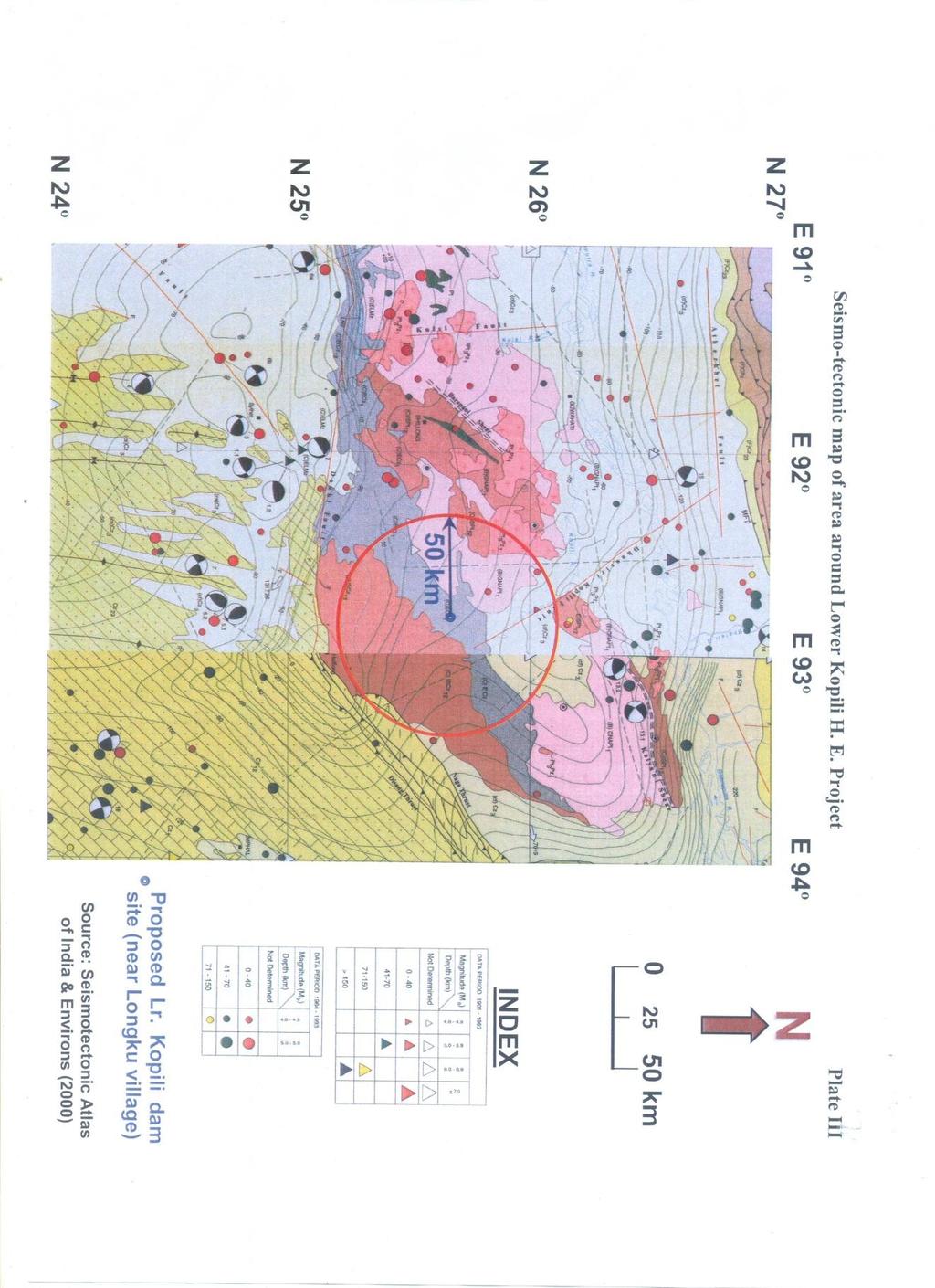
4 2. Inadequate Spillway Capacity at proposed Lower Kopili H.E. Project. The design spillway capacity of the proposed LKHEP is not as mentioned of Cumec. It is evaluated as Cumec which has been approved by CWC after detailed hydrological study made with H.M. data acquired from IMD Pune & New Delhi as stated in the para 1 above. The Lower Kopili Dam is designed for the above capacity which is inclusive of excess water spill over from Khandong Dam and inflow from the intervening undisturbed catchment area of 788 sq km upto Lower Kopili Dam.. Hence the design spillway capacity of LKHEP is adequate to pass off the PMF of Cumec. 3. Acidity of the water in River Kopili. Water of Kopili River is acidic at the proposed LKHE project site. Therefore special measures are to be adopted, to protect the Electro mechanical and Hydro mechanical equipment and river water exposed surface of concrete of the Proposed project. APGCL has taken the following decisions:- i) Adopt similar measures taken by MeSEB for Myntdu Leshka HEP, Meghalaya. ii) Stainless steel to be provided to all H.M. and E/M equipment, reinforcement, steel liner etc. ii) iii) Concrete admixtures to be used for all water contact surface to mitigate adverse impact of acidity. Avail expert consultancy from CWC for acidity problems. This is the one of the reason for enhancement of project cost. It may be stated that activity of the proposed LKHEP would not aggravate any acidity factor in the river and in its downstream during as well as in post construction stage, the acidity in the river is only due to open cast mining in the upper catchment areas located in the state of Meghalaya. Similar problems have been experiencing by NEEPCO as well as by MeSEB for Kopili and Myntdu Leshka HEP respectively. The MeSEB has proposed to use acid resistant coated steel materials which were tested at CSMRS lab during July 2013.The test results revealed that the coated materials found suitable to resist acidic hydro environment and no major deterioration of the paint and colour. 4. GSI NE region had done extensive details surface and sub-surface geotechnical investigation since to and to Locations of various components were fixed as per the guidance of Engg Geology Division GSI, Shillong. GSI in its Geo technical report for LKHEP has mentioned about the existence of Dhansiri- Kopili fault located near to the project site (refer Plate-III of the report, enclosed). As per available records, major Earth Quake > 5 in Ritcher Scale were occurred during the period within 50KM radius of the proposed project site (Refer: Plate-II of the report).
5 IIT Roorkee inter alia considered the aforesaid report while carrying out studies for determination of site specific design Earth Quake Parameters for LKHEP (June 2012). Based on these parameters, design of various project components have been done. Further, APGCL has already initiated actions to install 3-4 seismographs network at the proposed LKHEP site for MEQ studies. As per Central Water Commission (Guidelines for Preparation and Submission of Site Specific Seismic Study Report of River Valley Project to National Committee on Seismic Design Parameters), for dams exceeding the height of 100 m, the details of micro earthquake data recordings around the dam site within a radius of 50 km should be provided incorporating full catalogue information for a period of at least six months. The maximum height of the proposed Lower Kopili H.E. Project dam is only m. 5. APGCL presented the project before the EAC in three occasions i.e. Dec 12, March 13 and latest on 24the September Based on the observations of EAC, APGCL has reviewed the land area to be acquired for the project.. Compensation to project affected families will be given as per the norms of NRRP-2007 of Government of India. 6. Form-I has been revised considering observations of EAC. Area and land use pattern to be acquired have also been revised in item 1.1.of Form-I. Hence the revised Form-I submitted on should be treated as final. 7. APGCL is committed to address the local issues particularly project Affected Families with priority. 8.Reservoir submergence was shown as 620 Ha in the earlier PFR.In the said PFR, a provision of 2.00 m above the MWL of m was kept in the reservoir area of 620 Ha as a cushion for allowance of any subsidence on the reservoir periphery due to draw down effect of fluctuation of water level. To comply the observation of EAC, the land area under submergence has been re assessed as Ha considering submergence in the reservoir area upto MWL only.
6
7
8
9
10
11
12
13
14
15