and Reasons for creation (2001) >35,000 acres water rights leased by 2000
|
|
|
- Edward Shaw
- 5 years ago
- Views:
Transcription
 Municipal, Industrial, Agricultural b. Future Growth c. Reasonableness of Management Strategies d. Insufficient Science e. Unknown area future projects (in and out of District) f.")
1 POSGCD Background and Reasons for creation (2001) I. Resources + Location + Growth = II. >35,000 acres water rights leased by 2000 Local Concerns a. Existing Area Users (100% Burl. Co., 90% Milam Co.- use groundwater) Municipal, Industrial, Agricultural b. Future Growth c. Reasonableness of Management Strategies d. Insufficient Science e. Unknown area future projects (in and out of District) f. Property Rights
2 Groundwater Management Toolbox POSGCD PERMITS (Property rights, Property rights, ) Historic Use Permits (limited to life of the well) Local (Public) Water Utility Permits Automatic if production required for CCN by state or federal law Must meet Spacing Rules for rate of production Exempt from hearings Limited Production Permits Limited to 25,000 gallons per day Must meet contiguous acreage requirement Exempt from hearings Oil & Gas Frac Permit Must provide proof of right to produce (affidavit or lease) Limited to single use Exempt from hearings Aggregate Well Field Permits Production and Transport Permits
3 Groundwater Management Toolbox POSGCD COMMON RULES Production Permit Terms (40 years with 5 year reviews) Adjustable to meet Desired Future Conditions (DFCs) Adjustable to meet Protective Drawdown Limits (PDLs) Water Usage Reporting New Well Spacing- Aquifer Specific based on characteristics Spacing from nearest uncontrolled Property Line Spacing from nearest well in same formation Added vertical spacing for Yegua-Jackson Alluvial formations are exempt from spacing Maximum Production Rate Currently 2 Acre Feet/ Acre per Year (all inclusive) Adjustable & may be based on Management Zones Contiguous Acreage Requirement(Adjustable to meet DFCs & PDLs) Protective Drawdown Limits (DFC for shallow parts of aquifers) Water Level Monitoring is of utmost importance!
4 Groundwater Management Toolbox POSGCD ADDITIONAL/FUTURE TOOLS (Best Available Science!) Improvements to the Central Carrizo-Wilcox Groundwater Availability Model (GMA12) Cooperative work with TWDB, 3 other GCDs, 2 river authorities, plus 3 other entities Extended calibration period Improved values for recharge, storage, and transmissivity Improved representation of fault zones Improved predictive Surface Water-Groundwater interaction (Texas Water Journal) Aquifer Storage and Recovery Evaluations Predictive recovery efficiencies Affects of local pumping Evaluate opportunities for in-district projects Expanding Water Level Monitoring Network by end of 2018


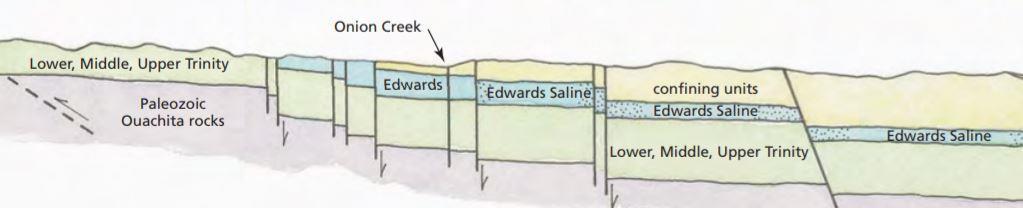
5 Barton Springs/Edwards Aquifer Conservation District Established: 1987 by landowner petition Funding: Fee Based, statutory City of Austin fee Edwards: Barton Springs pool, endangered Species, PWS Trinity: Shared Territory with EAA after 2015 annexation


6 Aquifers: Edwards and Trinity and other aquifers(austin Chalk)
7 Evolving Regulatory Framework District created by landowner petition 1987 to 2004 Historic Permits 2004 Sustainable Yield Study (Edwards) 2004 Conditional Permits Management Zones Annexation of Shared Territory (HB 3405) 2016 Defined Unreasonable Impacts Sustainable Yield Conditional Permits Management Zones DFCs HCP Unreasonable Impacts Conditional Permits 2007 Extreme Drought Withdrawal Limitation 2009 Ecological Flow Reserve DFC determination 2014 Habitat Conservation Plan (Endangered Sps)

8 Management Toolbox (Science Informs the Policy) Policy Tools Non Speculative Reasonable Demand Historic Use Conditional Permits Drought Management Management Zones Endangered Species/HCP Special Conditions Annual Permit Renewal Meter Reporting Production Fees Science Tools Aquifer Testing Monitor Well Networks Index wells/compliance triggers Multiport Wells Dye Tracing Aquifer Research Supply Side Management Alternative Supplies (ASR, Desal) Recharge Enhancement

9 Drought Management Drought Mgmt


10 The District's goal is to manage total production while avoiding unreasonable impacts Reasonable Non Speculative Demand Beneficial Use Reasonable Use Regional Evaluations Desired Future Condition Groundwater Availability Models Conceptual, Numerical, Analytical Models Local Evaluations Aquifer Tests Well Monitoring Data Collection & Evaluation Analytical Models
11 Special Permit Conditions & Conditional Permitting


12 Sustainable Yield has been a part of BSEACD Management Policy 2004 Findings 1:1pumping to springflow Under DOR, without pumping curtailments: Barton Springs may cease flowing 19% of the wells in the District may go dry Management Goals: Sustainable yield Preserve minimum spring flows Preserve water well supplies Allow reasonable nondrought pumpage Drought DFC: minimum of 6.5 cfs of springflow during recurrence of DOR conditions
13 2004 Conditional (Interruptible) Permits During Average Conditions (No Drought) District Preserves the DFC by only allowing 16 cfs of groundwater production 16 Non-Drought During Extreme Drought Conditions District Preserves the DFC by only allowing 5.2 cfs of groundwater production Extreme Drought 10 Cond l Production available for Conditional Permits 100% Cond l Conditional Permits are fully curtailed 100% Pumping (cfs) Production allocated for Historic Permits. 5 Historic 50% Historic Permits are curtailed max 50% 0 Exempt Historic Exempt E Remaining active Production for Historic Permits
14 Groundwater Management Toolbox Public Water Utility CCN Permits Brackish Water Oil & Gas Permit Exemptions Concentrated Well Field Permits
15 Groundwater Management Toolbox Common Rules Aquifer Production Rates Production Permit Terms (5 years) Water Usage Reporting Property Line Well Spacing Peaking Production Rates (150% of permitted production rate) Aggregate Well Permits Special Conditions Groundwater Ownership/Contractual Rights vs CCN Permits vs Exemptions Single Wells vs Concentrated Well Field
16 Gonzales UWCD Special Conditions Public Water Utility CCN Permits Well must be located within CCN Eliminate claimed acreage (permitted/leased/sold) Brackish Water Oil & Gas Exemptions Wilcox, Carrizo, Queen City, Sparta Aquifers well completed in downdip area where water quality exceeds 3,000 ppm TDS Yegua-Jackson Aquifer well completed and screened below 350 feet Concentrated Well Field Agreements Mitigation Agreement Monitor Well Agreement Negotiated Fee Agreement vs Export Fee
17 POSGCD Special Conditions Permits are adjustable (Rules- Section 16) Treat all property owners equally in opportunity to produce To achieve Desired Future Conditions (DFCs) To achieve Protective Drawdown Limits (PDLs) Additional Applicant may obtain a variance from neighbor to meet spacing or contiguous acreage requirements Required Mitigation Certain Exemptions with proof of property rights
18 Mitigation/ Conservancies
19 Gonzales County UWCD Mitigation Fund Funded by permittees capable of producing greater than 3,000 ac-ft/ year (Voluntary) Managed by the Gonzales County UWCD Mitigation Fund Areas Eastern and Western Wells Covered by Mitigation Fund Drilled before permits granted Completed in Carrizo Aquifer Non public supply wells Meet criteria for mitigation
20 Mitigation Work Lower pumps in wells to a depth that exceeds the anticipated 50 year water level declines based on GAM Restrictions in well or well too shallow: Plug and abandon and install replacement well and pump Plug and abandon and connect to public water supply Plug and abandon and replace with stock tank Former flowing wells Connect to power grid and install electric pump Install solar pump
21 Mitigation Costs Costs to Date ( ) - $1,323,142 Electric Grid Connections - $46,700 Eighteen Well Redrills - $6,500 - $21,000 Eighty-three Pumps Lowered - $3,200 - $14,900 Twenty-two Solar Pumps - $3,800 - $19,000 One Public Water Supply Connection - $2,500
22 POSGCD New Tools Board Dashboard (on website) Coordination of committees, staff, and consultants Transparency to, and inclusion of public Groundwater Well Assistance Fund (GWAP) Developed in response to citizens request & Stakeholder driven Developed after review of existing mitigation programs (GCUWCD) Addresses consequences of balance between production and conservation Provide assistance for wells affected by aquifer-wide production Proactive- address needs 10 years before wells affected Also addresses unexpected emergencies Encourages additional wells in POSGCD Water Level Monitoring Network Funded by stand-alone budget item Adopted January 2018
23 POSGCD NEWEST TOOL POSGCD Aquifer Conservancy Program (PACP) Developed in response to citizens request & stakeholder driven Specific to land over the Carrizo-Wilcox in POSGCD Create legacy of stewardship of groundwater resources by conserving groundwater for future generations Completely voluntary with flexible terms, & Exempt wells are acceptable Creates partnership between landowners and POSGCD in conservation Financial reward for not producing or permitting non-exempt amounts
 (continued) Landowner maintains ownership of resource Long range and big picture- will survive current Board and management Creates a balance in property")
24 POSGCD NEW TOOLS! POSGCD Aquifer Conservancy Program (PACP) (continued) Landowner maintains ownership of resource Long range and big picture- will survive current Board and management Creates a balance in property rights (produce vs. not produce) Works in conjunction with other POSGCD management strategies (tools) Participants remain eligible for all other POSGCD programs Funded by stand-alone budget item Anticipate adoption January 2019
25 Grant or Deny the Full Permit Request Permit Options that Board could consider Grant Permit with Special Conditions Reduce the permit significantly upfront Phased In Permits with criteria Proactive avoidance measures Monitoring and response curtailments Mitigation response plan for unexpected problems

26 Compliance Index Wells Trigger 1 WL Trigger 2 WL Trigger 3 WL Trigger 4 WL Scientific evaluation 20 % curtailment 40 % curtailment 100 % curtailment Top of Aquifer The aquifer will not be dewatered Top of Aquifer Pumps will not go dry
27 Groundwater Management Zones

28 Management Zones

29
30 Management Zone Boundaries Trinity MZ Shallow Wilcox MZs (includes Simsboro) Alluvium MZ Deep Wilcox MZs (Simsboro), Deep Carrizo MZ, and Queen City / Sparta / Yegua Jackson MZ Presented by URS on April 12, 2005
, Deep Carrizo MZ, and Queen City / Sparta / Yegua Jackson MZ Presented by URS on April 12,")
31 Management Zone Boundaries Trinity MZ Shallow Wilcox MZs (includes Simsboro) Alluvium MZ Deep Wilcox MZs (Simsboro), Deep Carrizo MZ, and Queen City / Sparta / Yegua Jackson MZ Presented by URS on April 12, 2005