Westminster East Garden Grove, California Flood Risk Management Feasibility Study
|
|
|
- Kenneth Webster
- 5 years ago
- Views:
Transcription


1 1 Public Scoping Meeting Westminster East Garden Grove, California
2 AGENDA 2 Orange County Public Works U.S. Army Corps of Engineers Study area problems & context Inventory of existing conditions Plan formulation process Plan evaluation Environmental analysis Schedule and Next Steps Discussion
3 ORANGE COUNTY FLOOD CONTROL DISTRICT Authority 3 Orange County Flood Control Act of 1927 An Act to create a flood control district to provide for the control and conservation of flood and storm waters, and for the construction of works and the acquisition of property therefor Governed by the Board of Supervisors of Orange County Primarily the responsibility of OC Public Works Flood Risk Objective To provide 100-year flood protection to all residents of Orange County Non-Federal Objective

4 PROJECTS COMPLETED SINCE 2003 Completed Projects 4

5 PROJECTS PLANNED TO BE COMPLETED BY OCPW Planned Projects 5
6 U.S. ARMY CORPS OF ENGINEERS Authority 6 House of Representatives Committee on Public Works May 8, 1964 (Flood Control Act of 1938) the Board of Engineers for Rivers and Harbors is hereby requested to review the reports on (a) San Gabriel River and Tributaries, published as House Document No. 838, 76th Congress, 3d Session; (b) Santa Ana River and Tributaries, published as House Document No. 135, 81st Congress, 1st Session; and (c) the project authorized by the Flood Control Act of 1936 for the protection of the metropolitan area in Orange County, with a view to determining the advisability of modification of the authorized projects in the interest of flood control and related purposes. Study Objective To identify a plan that addresses flood risk and also maximizes the total net benefits (benefits costs). Federal Objective

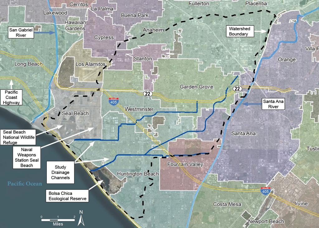
7 7 STUDY AREA Westminster Watershed Orange County, CA 87 square miles 400,000 residents 44,000 structures Dense urban land use 25 miles of flood control channels Connects to Pacific Ocean at Anaheim Bay 199 acres of freshwater wetland 32 acres of marine wetland Context
8 8
9 STUDY AREA PROBLEMS 9 Drainage channels don t have the needed capacity Highly urbanized (impermeable surfaces) Damages to property, businesses, and infrastructure Regional traffic delays Risks to life safety Risks to sensitive ecological areas Study Area Problems

10 10
11 STUDY AREA PROBLEMS Widespread flooding may occur during moderate storm events Traffic Impact ~3700 structures and ~$90M annual damages The 405, Garden Grove Fwy, PCH Local roads C02 and C05 levees may breach and overtop into sensitive areas C02 Seal Beach National Wildlife Refuge C05 Bolsa Chica Ecological Reserve Study Area Problems 11


12 EXISTING CHANNEL CONDITIONS Constructed During 50s-60s Earthen Trapezoidal 12 Riprap Trapezoidal Over time, OCPW has modified some reaches: Concrete Trapezoidal Concrete Rectangular Steel Sheet Pile Inventory of Existing Conditions


13 EXISTING DOWNSTREAM CONDITIONS 13 Warner Avenue Bridge Existing bottleneck Causes backwater flooding upstream in C05 and OBB Causes erosion in BCER Pacific Coast Highway Flooding exacerbated under high tide conditions Erosion from flood flows Tide Gates Existing bottleneck Causes backwater flooding in C05 Currently leak saltwater habitat Inventory of Existing Conditions
14 PLANNING PROCESS (1/5) 14 Inventory and Forecast Existing Conditions Plan Formulation and Selection Hydraulic Modeling Economic Damages Alternative Plans Compare & Select Plan Formulation Process
15 PLANNING PROCESS (2/5) Hydraulic Modeling Determine extent of expected flooding Existing and with-project conditions Multiple storm events Plan Formulation Process
16 PLANNING PROCESS (3/5) Economic Damages Run economic models to forecast impacts of flooding using depth-damage correlations Structure inventory Structure contents Traffic delays Plan Formulation Process

17 PLANNING PROCESS (4/5) Alternative Plans Potential plans to reduce flood risk must be technically sound, environmentally acceptable, and economically justified Combinations of management measures Evaluated with hydraulic & economic models Plan Formulation Process
18 PLANNING PROCESS (5/5) Compare & Select USACE selects the alternative plan the maximizes net benefits Benefits = avoided damages Net benefits = benefits cost Greatest net benefits is called the National Economic Development Plan (NED) Or identify a Locally Preferred Plan (LPP) Plan Formulation Process
19 MANAGEMENT MEASURES 19 A feature or activity that can be implemented to address one or more planning objective. Nonstructural Measures In-Channel Modifications Upstream Modifications Downstream Modifications Flood Proofing Removing Structures Channel Lining Floodwalls Bypass Channels Levees Raising PCH Dredging Outer Bolsa Bay Removing Impediments to Flow Altering Channel Geometry Retention Basins Removing Tide Gates on C05 Plan Formulation Process
20 MANAGEMENT MEASURES 20 Nonstructural Measures In-Channel Modifications Upstream Modifications Downstream Modifications Measures Retained Screened Out Floodplain Regulation - X Emergency Response - X Evacuation Planning - X Flood Proofing - X Flood Warning System X - Razing/Removing Structures - X Removal of Impediments to Flow X - Lining Channels with Concrete X - Altering Channel Geometry X - Flood walls X - Pump Station Improvements - X Construct new ocean outlet (approx. 30' diam. tunnel) - X Diversion/Bypass Channels X - Storage/Retention Basins - X Dams - X Levees - X Santa Ana River (SAR) Diversion - X Raising Pacific Coast Highway (PCH) - X Constructing a Floodwall along Pacific Coast Highway (PCH) X - Removing Tide Gates on CO5 - X Reconstructing/Relocating Tide Gates on CO5 X - Widening the Existing Bottleneck at Warner Avenue X - Dredging in Outer Bolsa Bay - X Intentional Breaching of the Levee on CO5 Adjacent to the Muted Tidal Pocket - X Measures
21 ARRAY OF ALTERNATIVES 21 Minimum Channel Modifications Increase efficiency Improve channel lining materials Maximum Channel Modifications Increase efficiency and capacity Modify channel lining and geometry Contain 100-year storms Before After OR Concrete Rectangular Steel Sheet Pile Moderate Channel Modifications (Hybrid Plan) Increase efficiency and capacity Channel lining and geometry Incremental analysis Efficiency/Lining Plan Formulation Process Capacity/Geometry
22 MINIMUM CHANNEL MODIFICATIONS PLAN 22 Minimum Channel Modifications Before After Downstream Modifications Expand Warner Ave. Bridge PCH Floodwall Replace Tide Gates Plan Formulation Process

23 MINIMUM CHANNEL MODIFICATIONS PLAN The downstream reaches of C02 and C05 receive maximum channel improvements in all alternatives. C02 C05 C04 C05 C06 In-Channel Modifications Downstream Modifications Lining Channels with Concrete Reconstructing Tide Gates on CO5 Widening Bottleneck at Warner Ave Constructing a Floodwall along PCH 23

24 24 MAXIMUM CHANNEL MODIFICATIONS PLAN Maximum Channel Modifications + After Before After Bypass Channel Downstream Modifications Expand Warner Ave. Bridge PCH Floodwall Plan Formulation Process Replace Tide Gates
25 MAXIMUM CHANNEL MODIFICATIONS PLAN C02 C05 C04 C05 C06 In-Channel Modifications Upstream Modifications Downstream Modifications Altering Channel Geometry Flood Walls Diversion/Bypass Channels Reconstructing Tide Gates on CO5 Widening Bottleneck at Warner Ave Constructing a Floodwall along PCH 25
26 PRELIMINARY NATIONAL ECONOMIC DEVELOPMENT & LOCALLY PREFERRED PLANS 26 NED/LPP Plan Name Total First Cost ($1,000) Preliminary Equivalent Average Annual Values Benefits ($1,000) Costs ($1,000) Net Benefits ($1,000) BCR Apparent NED Minimum Channel Modifications $823,500 $145,300 $43,500 $101, LPP Maximum Channel Modifications $1,476,000 $160,500 $74,400 $86, Apparent NED Plan is subject to change based upon subsequent detailed analysis and design. 1 - Dollars are expressed in 2019 Price Levels, assuming a base year of 2035, a 50 year period of analysis, and a Federal Discount Rate of 2.875% Plan Evaluation


27 27 ENVIRONMENTAL ANALYSIS eelgrass green sea turtle Belding s savannah sparrow

 www.ca.audubon.")
28 ENVIRONMENTAL RESOURCES (1/ federally-listed species 77 state-listed species 2 Special Marine Conservation Areas Bolsa Bay Bolsa Chica Basin Potential to impact: Nesting birds Green sea turtle Upland and adjacent fringe wetland (Warner Avenue Bridge and PCH floodwall) Eelgrass (Warner Ave. Bridge) In-channel wetlands/softbottom habitat Inner Bolsa Bay Muted Tidal Pocket Pacific Coast Highway (PCH) green sea turtle eelgrass C05 Belding s savannah sparrow Seasonal Ponds
 located approx.")
29 29 ENVIRONMENTAL RESOURCES (2/2) Essential Fish Habitat (EFH) No Pacific Salmon EFH, Habitat Areas of Particular Concern, or EFH Areas Protected from Fishing within project vicinity EFH for Pacific Highly Migratory Species (PHMS) located approx. 1 mile off coast Temporary impacts anticipated Channel Species Groundfish C02 Coastal Pelagic Species Finfish & Market Squid C05 C02 Groundfish Coastal Pelagic Species Finfish & Market Squid Reach 23 Reach 1 Reach 2 Reach 1 C04 C05 C06 *Coastal Pelagic Species and Finfish & Market Squid EFH overlap on map Reach with EFH Environmental Analysis
30 PRELIMINARY MITIGATION REQUIREMENTS (1/2) 30 Goal: Offset increment of loss in fish and wildlife habitat resulting from implementation of NED or LPP National Economic Development Plan (NED) Total preliminary mitigation requirement: ~25 acres Locally Preferred Plan (LPP) Total preliminary mitigation requirement: ~11 acres Alternative Site 1 Site 2 Preliminary Mitigation Requirements (acres) C02/C04 Channels C05/C06 Warner Ave. Bridge PCH Floodwall NED LPP Environmental Analysis


31 PRELIMINARY MITIGATION REQUIREMENTS (2/2) Potential mitigation opportunities at Bolsa Chica Ecological Reserve (BCER) being discussed 3 opportunities identified East bank terracing C05 overflow weir Tern islands Mitigation Plan is being coordinated with environmental resource agencies Detailed analysis will be Site 2 included in final report Environmental Analysis 31
 Effects NOT Found to be Significant Mineral resources Agriculture and forestry Land use and planning Population and housing Public services Environmental")
32 NATIONAL ENVIRONMENTAL POLICY ACT (NEPA)/CALIFORNIA ENVIRONMENTAL QUALITY ACT (CEQA) 32 Preliminary impacts analysis conducted Adopted significance thresholds from CEQA guidelines (Appendix G) Effects NOT Found to be Significant Mineral resources Agriculture and forestry Land use and planning Population and housing Public services Environmental Analysis
 Effects Found")

33 33 NEPA/CEQA CONT. Preliminary impacts analysis conducted Adopted significance thresholds from CEQA guidelines (Appendix G) Effects Found to be Significant, BUT can be reduced to less than significant with environmental commitments Earth Resources Water Resources Air Quality Greenhouse Gas Emissions Socioeconomic /Environmental Justice Recreation Aesthetic Quality Hazards & Hazardous Materials Traffic and Transportation Utilities and Service Systems Environmental Analysis
 Effects Found to be Significant AND Unavoidable Noise and")
34 NEPA/CEQA CONT. 34 Preliminary impacts analysis conducted Adopted significance thresholds from CEQA guidelines (Appendix G) Effects Found to be Significant AND Unavoidable Noise and vibration Biological resources Ongoing Evaluation to Determine Preliminary Effects Cultural resources Tribal cultural resources Environmental Analysis
35 STUDY SCHEDULE 35 Alternatives Milestone briefing Feb 2014 Alternatives Milestone approved June 2014 Tentatively Selected Plan Milestone 25 Jul 2018 Draft report released Start of public/concurrent reviews 20 Oct 2018 Public Meetings 7-8 Nov 2018 End of public/concurrent reviews 3 Dec 2018 Receipt of final IEPR Comments, when applicable Dec 2018 Agency Decision Milestone Jan 2019 District Engineer s transmittal of final report package Sep 2019 Senior Leader Briefing Dec 2019 Chief of Engineer s Report signed Jan 2020 Record of Decision (ROD) signed Summer 2020 Schedule & Next Steps
36 NEXT STEPS (1/2) 36 Congressional Authorization Funding for Design Construction Appropriation 2022 Project Construction ~15years Project Completion ~2038 Next Steps
37 NEXT STEPS (2/2) 37 WHAT S NEXT FOR RESIDENTS IN THE FEMA FLOODPLAIN? 1. Coordinate with FEMA prior to construction FEMA issues CLOMR 2. Construct the project Submit request for LOMR 3. FEMA reviews and approves LOMR 4. FEMA goes through regulatory mapping process Issues PMR (up to 18 mo.) Next Steps
38 QUESTIONS AND DISCUSSION 38 WE WANT TO HEAR FROM YOU! East-Garden-Grove/ Or search Google for USACE Westminster Submit your comments by DECEMBER 3, 2018: Spoken comments Handwritten comment cards Send a letter to: Orange County Public Works ATTN: Justin Golliher 300 N. Flower Street Santa Ana, CA Discussion