Colorado River: Drought Contingency Planning Wyoming s Little Snake and Green River Basins October 15, 2018
|
|
|
- Sabina Small
- 5 years ago
- Views:
Transcription


1 Colorado River: Drought Contingency Planning Wyoming s Little Snake and Green River Basins October 15, 2018 Cheyenne Meeting and Webinar Wyoming State Engineer s Office Glen Canyon Dam and Lake Powell 1
2 Presentation Outline Drought Contingency Planning Overview The Colorado River Basin and Wyoming Water Uses Primary Law of the River Elements Current Conditions Drought Contingency Plans The Upper Basin Plan The Lower Basin Plan Current Timeline 2
3 Drought Contingency Planning Overview Over the past decade, drought in the Colorado River Basin has increased the risk of reservoirs declining to critically low elevations by nearly fourfold. Current operational rules on the Colorado River are insufficient to protect against reservoirs declining to critically low elevations if dry conditions persist or worsen. Beginning in 2013, in response to these historic drought conditions, the seven Colorado River Basin States, the Department of Interior and the Republic of Mexico have been working on Drought Contingency Plans (DCPs). Urgency has increased due to this year s very poor hydrology. 3
4 Drought Contingency Planning Overview The draft DCP Agreements include an Upper Basin DCP and a Lower Basin DCP. Modeling studies of the DCPs indicate that, when implemented together with Mexico s agreed upon plan, the risk of reaching critical elevations in Lakes Powell and Mead through 2026 is significantly reduced (Averaging 5% or less). The Upper Basin DCP is designed to: 1. Protect critical elevations at Lake Powell and help assure continued compliance with the 1922 Colorado River Compact; and 2. Authorize storage of conserved water in the Upper Basin that could help establish the foundation for a Demand Management Program that may be developed in the future. 4
5 Drought Contingency Planning Overview The Upper Basin DCP consists of two draft agreements: The Drought Response Operations Agreement and the Demand Management Storage Agreement The Drought Response Operations Agreement: Conserves water in Lake Powell through operational adjustments or by moving available water from upper CRSP facilities (Aspinall, Flaming Gorge, Navajo). Does not provide for the operation of any reservoir outside of existing authorities. Requires recovery of storage as part of any Drought Response Operations plan. The Demand Management Storage Agreement: Authorizes storage in federal reservoirs to be used by the Upper Division States, at no cost, to hold conserved consumptive use for compact compliance. Sets the stage for a future demand management program if stood up by the UCRC and the Upper Division states. Does not establish a Demand Management Program: That will require answering numerous technical and policy questions in the future with multiple stakeholders (agriculture, industry, municipal, environmental, recreation) at the table during development. 5
6 Drought Contingency Planning Overview Lower Basin DCP is designed to: 1. Require Arizona, California and Nevada to contribute additional water to Lake Mead storage at predetermined elevations; and 2. Create new flexibility to incentivize additional voluntary conservation of water to be stored in Lake Mead The Lower Basin DCP: Includes participation by California even though it doesn t share in current shortages. If executed, triggers additional contributions already agreed to by Mexico. Also benefits reservoir elevations in Lake Powell. 6
7 Colorado River Basin and Wyoming Water Uses 7 7

8 Colorado River System: CO River Basin drains nearly 250,000 Square Miles. Provides water to seven U.S. States and two Mexican States. Supplies water to 40 million people and 5.5 million acres of irrigated lands. Served area has economic value of approx. $1.4 trillion annually. Capacity to store four years of average annual flow. 8

9 Colorado River Basin Includes areas outside of the Basin beneficially served by System water. Cheyenne: Approx. 8,000 acre feet per year. 9

10 In Wyoming, the Colorado River Basin covers about 17,000 square miles, including the areas drained by the Little Snake and Green Rivers. 10

11 Wyoming CO River Water Uses 11


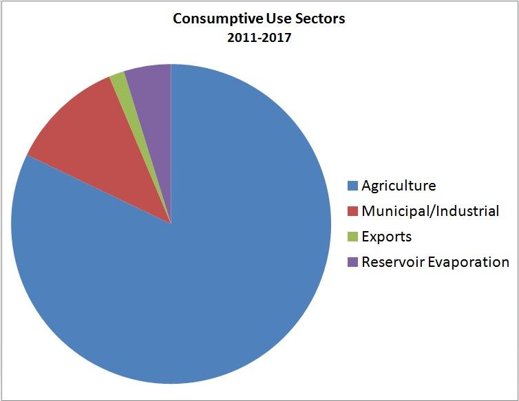
12 Wyoming CO River Water Uses 12
13 Primary Law of the River Elements 13 13
14 Law of the River Law of the River: Some Primary Elements: Colorado River Compact, 1922 Boulder Canyon Project Act (1928) Mexican Water Treaty, 1944 The Upper Colorado River Compact, 1948 Colorado River Storage Project Act (1956) Arizona v. California (1963) Colorado River Basin Project Act (1968) The Big Three Interim Guidelines for Lower Basin Shortages and Coordinated Reservoir Operations (2007) Minute 323 to the Treaty with Mexico 14
15 1922 Compact Apportions the River Lee Ferry Upper Division Basin States Lower Division Basin States Harvard University Water Federalism Conference,
16 1922 Compact Apportions the River Annual apportionments to each Basin: The Compact does not apportion water, it apportions the exclusive beneficial consumptive use of water. Art. III (d) - Upper Division states shall not cause the flow at Lee Ferry to be depleted below an aggregate of 75,000,000 acre-feet for any period of ten consecutive years. Lower Basin 7.5 MAF + 1 MAF 8.5 MAF Upper Basin 7.5 MAF Total Aggregate Apportionment: 16 MAF Harvard University Water Federalism Conference,

17 Boulder Canyon Project Act (1928) (Authorized Construction of Hoover Dam) Mainstream users in each Lower Basin State must have a direct contract with Reclamation, or receive water through a State agency which has a direct contract with Reclamation. The Secretary of the Interior is the water master. Lake Mead sits above most LB water users. 17
18 Treaty with Mexico, 1944 Upper Basin 7.5 MAF Lower Basin 8.5 MAF Total Apportionments U.S. and MX: 17.5 MAF Mexico 1.5 MAF Harvard University Water Federalism Conference,
19 Upper Colorado River Basin Compact of 1948 Divides the Upper Basin s allocation between Arizona, Colorado, Utah, New Mexico, and Wyoming. Apportions the consumptive use of water. Establishes requirements for each Upper Division state with respect to the obligation not to deplete flows of water at Lee Ferry under Colorado River Compact. Makes provisions for possible curtailment of use of Colorado River water. Prior perfected rights excluded. Establishes the Upper Colorado River Commission. 19
20 Upper Colorado River Commission One commissioner from each of the Upper Division states and one commissioner representing the US. Commission Powers: Adopt rules and regulations Make findings as to: Extraordinary drought in the Upper Basin Upper Basin water use Lee Ferry deliveries (if necessary) Necessity for, extent and timing of curtailment if any is required. Reservoir losses Engage in cooperative studies Collect and analyze river data UCRC does NOT have authority to determine how curtailment will be implemented within an individual state. 20

21 Wyoming s current estimated-average use: 546,000 acre feet. 21
22 Upper Basin Apportionment Wyoming: 14% Full: 1,043, : 834,400 Current: 546,000 Arizona 50,000 AF Utah: 23% Full: 1,713, : 1,370,800 Current: 865,000 Total UB Full: 7.5 MAF Current: 5,056,000 (includes 520,000 AF CRSP evaporation) Colorado: 51.75% Full: 3,855, : 3,084,300 Current: 2,595,000 New Mexico: 11.25% Full: 838, : 670,500 Current: 530,000 Current use based upon the December 31, 2016, Current and Future Depletion Demand Schedule. Harvard University Water Federalism Conference,
23 Lower Basin Apportionment 1922 Compact; Boulder Canyon Project Act (1928); AZ V. CA Decree, Nevada Mainstream 300,000 (2017: 243,425) Total LB Mainstream Apportionment: 7.5 MAF California Mainstream 4,400,000 (2017: 4,026,515) Arizona Mainstream 2,800,000 (2017: 2,509,503) Harvard University Water Federalism Conference,


24 Structural Deficit 24


25 2007 Interim Guidelines Coordinated Operations Coordinated Operations Lake Mead Lake Powell 25
26 2007 Interim Guidelines: Coordinated Reservoir Operations Lake Powell and Lake Mead Equalize Lake Powell current elevation is 3,592 ft 8.23 or balance if Mead low 7.48 or 8.23 if Mead low Balance 26
27 2007 Interim Guidelines Lower Basin Shortages and Intentionally Created Surplus Shortages in the Lower Basin: Insufficient mainstream water to satisfy 7.5 MAF LB use. Based upon Lake Mead elevations: 1,075, 1,050, and 1,025. The lower the elevation, the greater the shortage. Only Arizona (up to 480kaf) and Nevada (up to 20kaf) take shortages. California does not take shortages. Mexico has also agreed to take proportional shortages (Minutes 319 & 323). Intentionally Created Surplus (ICS) Allows LB users to invest in conservation or augmentation and to bank that water in Lake Mead for later use without other LB users claiming the water. Provides incentive to conserve water because it can be stored: increases flexibility. Intended to promote higher reservoir elevations and avoid shortages. Most common form is Extraordinary Conservation ICS (EC ICS). Includes projects such as fallowing of land that was historically irrigated and canal lining. Subject to creation, total storage, and delivery limitations.
28 Current Conditions 28 28

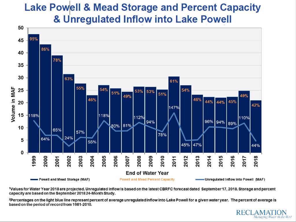
29 August 2018 only 2% of Average. September 2018 was less than 1% 29
30 30

31 Total Capacity = 50.4 MAF Current Storage = 21 MAF or 42% 31
32 Elevation ~3,490 feet at Lake Powell, but negative impacts to power generation occur at higher elevations. Increased risk of not meeting Compact obligations. Only 4 MAF In Lake Powell at elevation 3,490. Could we even get enough water out? Loss of power generation impacts: Lose large clean power supply/soft start capability for western grid. Lose funds for: Repaying for construction of projects. Operating and maintaining Glen Canyon, Aspinall, Flaming Gorge, Navajo, etc. reservoirs. Implementing compliance with Endangered Species Act, NEPA, and Grand Canyon protection legislation. Salinity mitigation. Basin Fund MOA: Projects within each UB State. 32
33 Begins with forecasted Jan elevation at Lake Powell: About 45% full Three recent droughts superimposed on Jan conditions (drawdowns based on historical record) No Drought Contingency Plans in place 3490 is the minimum power pool elevation: Impacts to power generation occur at higher elevations. Hydros Consulting Inc. 33
34 Drought Contingency Plans (DCPs) 34 34
35 35
36 36
37 Upper Basin Drought Contingency Planning Why are we doing it? If critical elevations are breached, the system faces threats to the ability to control its own destiny Compact compliance, irrigation, drinking water supply, power production, environmental resource preservation, and overall sustainability. The alternative to agreed upon plans in the Upper Basin is mandatory curtailment to meet compact obligations. Low probability but High Risk. Sensible to plan for the worst case scenarios to avoid potential controversy, conflict, litigation and uncertainty both within the Upper Basin and between Basins. Preparation for but not predicting need for implementation. 37
38 Colorado River Basin Drought Contingency Plan Documents and Agreements Federal Legislation Companion Agreement Lower Basin DCP* Upper Basin DCP LBDCP Agreement Operational Provisions Arizona Agreements - ICS Exhibits - Intra-State DCP Agreements - Legislation California Agreements - ICS Exhibits - Intra-State DCP Agreements Nevada Agreements - ICS Exhibits Drought Response Operations Agreement Demand Management Storage Agreement *Activates Section IV of Minute 323 (Binational Water Scarcity Plan)


39 Navajo Reservoir Flaming Gorge Reservoir Blue Mesa Reservoir Agree on a process to develop operational plans to implement under emergency drought conditions only to maintain minimum power pool elevation at Lake Powell. Lake Powell By conserving water (temporarily) in Lake Powell or moving water available (and subsequently recovering the storage) from upper CRSP facilities. 39
40 Establishes a process for the Upper Division States and Secretary to rely on available water supplies from the CRSPA Initial Units as needed to reduce the risk of Lake Powell dropping below elevation 3,525. 3,525 target elevation to help assure protection of Lake Powell s minimum power pool and infrastructure (somewhere between 3,490 and 3,525 ). The Agreement guarantees the States a role in how the decision is made. Reclamation has the authority to move the water anyway. Provides for consultation with the Lower Division States during the development and implementation of a drought response operations plan. 40
41 Example of principles to be considered during plan development include: Operate Units with maximum flexibility practicable to accomplish drought response releases and subsequent recovery of storage operations. Ensure all CRSPA Initial Units are considered given water availability, hydrology, resource conditions, and operational limitations. Remain consistent with existing authorities, and honor water and hydropower contracts. Recovery of storage is part of drought response plan. Consider natural resource conditions and impacts to Basin Fund and Bulk Electric System. Providing for emergency actions if need to protect target elevation is imminent. 41
42 Process summary for developing Plan: Start planning process when the Minimum probable forecast projects Lake Powell elevations may reach elevation 3,525 or below. - Monthly calls/meetings initiated to track conditions and status at Units. Develop draft operations plan when Most probable forecast projects Lake Powell elevations will reach elevation 3,525 or below. - Provide for timely adjustments based on actual monthly hydrology. - Requires subsequent recovery of storage. Conduct outreach with stakeholders on terms of draft operations plan. - Provide terms to Lower Division States for review. Finalize Drought Operations Plan. - Obtain UCRC approval and submit to Secretary for approval. Implement Drought Operations Plan. 42


43 Upper Basin Demand Management Be proactive in addressing variable hydrologic conditions in the basin. Assess methods to protect Wyoming water users from hard regulation in times of severe drought or basin curtailment. Temporary, voluntary and compensated conservation. Help assure full compliance with the Colorado River Compact without impairing existing water rights. Protect against Lake Powell reaching critical elevations. The UCRC has facilitated the System Conservation Pilot Program in the Upper Basin to inform the demand management element of its drought contingency plan. ( ) 43
44 Lots of issues exist Consistency with water law, protecting existing water rights, achieving the goal, accounting, management and administration, interest, shepherding, funding, economic and environmental. All need to be investigated before determining if demand management is feasible. Investigation and development of a Demand Management Program will require answering these numerous technical and policy questions in the future with multiple stakeholders (agriculture, industry, municipal, environmental, recreation) at the table during development. June 20, 2018 UCRC Resolution: Commission resolved to work with interested entities and parties to explore and investigate outstanding considerations related to demand management. 44
45 Authorizes storage of water conserved under an Upper Basin Demand Management program in the CRSP Initial Units, without charge, for the purpose of helping to assure continued compliance with the Colorado River Compact. This authorization does not expire. It does not establish an Upper Basin Demand Management Program. By securing the storage authorization, the UCRC can effectively consider the feasibility of a demand management program. The Agreement sets forth the minimum framework under which the Upper Division States can access the authorized storage prior to If, after study, the UCRC determines that a Demand Management Program is feasible then it may develop and implement a program. Program can only be implemented if approved independently by each of the Upper Division States. 45
46 Demand Management water stored prior to 2026 if a program is developed: Upon verification of the conservation and conveyance to the reservoir, will not be subject to release from Lake Powell through 2057 except upon the request of the UCRC for compact compliance purposes; Cannot cause a different release than would otherwise occur under operational rules; The water would have been consumptively used but for conservation as part of a demand management program not unused apportionment; Maximum combined storage limitation of 500,000 acre feet; Subject to proportionate share of evaporation; Reduced by physical spill from Glen Canyon Dam; and Subject to annual verification and reporting. After 2026, any demand management storage program would be informed by and considered as part of the renegotiation of the 2007 Interim Guidelines (set to begin in 2020). 46
47 Requires Arizona, Nevada and California to contribute water (DCP contributions) to Lake Mead in addition to shortages required by the 2007 Interim Guidelines (a total of 1.1 maf). Includes a commitment by the U.S. to work to create or conserve 100,000 acre feet of Colorado River system water. Includes voluntary reductions from California which otherwise does not take mandatory shortages. Increased flexibility permits recovery of additional conservation volumes under certain conditions. Incentivizes additional voluntary conservation: ICS creation/storage. This is conservation in addition to DCP contributions. DCP contributions converted to ICS may only be delivered when Lake Mead is at or above elevation 1,110, though there are provisions for short-term borrowing of DCP ICS 47

48 Contributions at higher elevations than 07 Guidelines shortages. California provides contributions even though it doesn t take shortages. Total volume of shortages and contributions at lower elevations: 1,375,000 acre feet. 48
49 Agreement that ties the Upper and Lower Basin DCPs together. Includes provisions regarding: Seven state support for each Basin s plan Transparency and good faith Enforcement Modification Notice and consultation Reservation of rights Resolution of claims No precedent The UB and LB DCP agreements will be attached and incorporated to the Companion Agreement. 49
50 The Basin States have collectively agreed to seek federal legislation authorizing and directing the Secretary to implement the proposed operations in the Upper and Lower Basin DCPs. The anticipated legislation would direct the Secretary of the Interior to sign and implement the entire DCP package of agreements upon the approval and execution by all other parties. It is anticipated that the States will propose very simple legislation through a seven state letter to the Congressional delegations of each State, with each of the draft documents attached, seeking the delegations active support for the federal legislation. 50
51 October: Final working draft agreements are made available (Oct. 9). Each Basin State conducts outreach with water users and other stakeholders. Final drafting of Agreements. November - LB water users begin to seek approvals for committing to obligations in LB DCP. Intrastate agreements in the LB being completed. Department of the Interior conducts internal review. Seven State letter sent to congressional delegations with all final agreements and proposed legislation. November - December Obtain federal legislation directing Secretary of the Interior to execute and implement the DCP agreements. Beginning January 2019 Obtain Arizona legislature approval of LB DCP allowing Arizona to sign. Early 2019 All parties execute all DCP agreements. 51
52 Contact Info.: Thank you! Questions? Patrick Tyrrell Steve Wolff Chris Brown