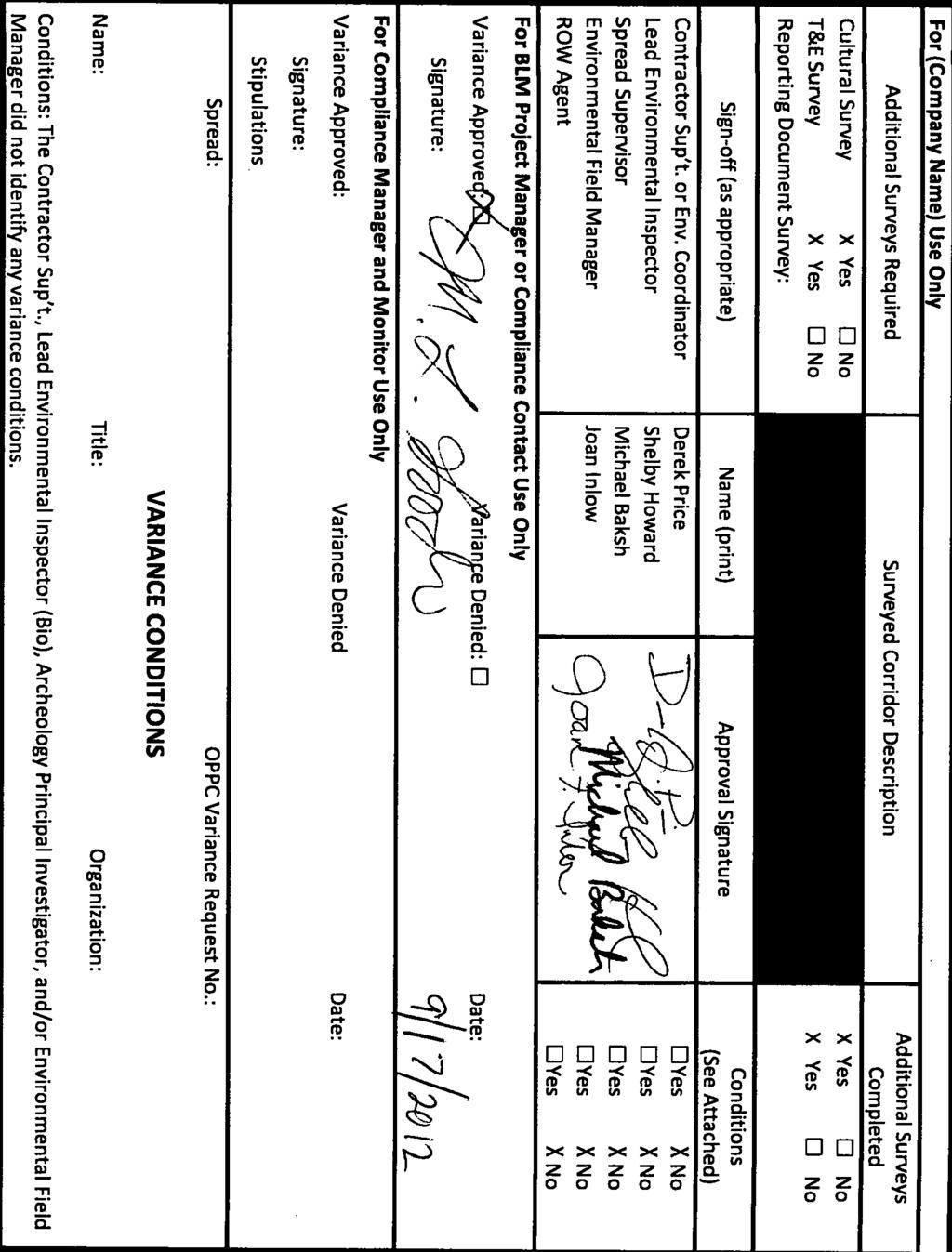
Variance Request Form
|
|
|
- Griffin Harris
- 5 years ago
- Views:
Transcription
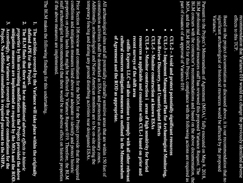
1 Variance Request Form Ocotillo Express Wind LLC Variance: 019 Pier 1 Bay 3 Request No.: Rev 0 San Francisco CA Date Submit: _8/30/ Date Approval Needed: 9/6/2012 Date Agency Received: Agency Approval Reference No.: Request Prepared by: Joan Inlow / James Dermody Spread/ Location: Access Road toward Turbine 73 (Milepost): Net acreage affected: 3.69 acres Alignment Sheet/Sta. No.: Tract No: Landowner: BLM In or within 50 feet of a wetland: Yes X No Current Land Use/ Vegetative Cover: Desert vegetation Nearby Features (Water body, T&E Habitat, Wetland, Noxious Weed): Water of the U.S. Area, Residence, Cultural Resource Site (distance, etc.): Within 50 feet of a water body: Yes X No Variance Level: Level 1 Level 2 X Level 3 (To Be Assigned by Designated Representative) Variance From: Permit Plan/Procedure Specification X Drawing Mitigation Measure Other: Detailed Description of Variance: Attachments? Yes X No Photos? Yes No X Variance 019 includes the realignment of the access road toward Wind Turbine 73 (see map attachment). The total length of the access road realignment is 2,210 feet with a maximum offset of 740 feet from the currently approved access road alignment. Variance Justification: The infrastructure shift for this project area is being proposed by OE LLC in order to comply with the mitigation measures identified in the Final EIS/EIR that direct the Project to minimize disturbances to sensitive environmental resources. As identified in Section 5 of the ECCMP, construction site conditions and subsequent environmental surveys could result in the need for changes from the approved work spaces. Changes to previously approved work spaces are handled in the form of variance requests submitted by OE LLC to be reviewed and approved or denied by the BLM. The variance procedures outlined in Section 5 of the ECCMP specify three different levels that a variance request may fall under. In accordance with the procedures and guidance provided in the ECCMP, OE LLC is requesting a Level 3 variance to modify permanent access toward Wind Turbine 73. As identified in Section 1.6, Level 3 variances involve project changes that would affect an area outside the previously approved work area that are also outside the areas previously surveyed for cultural resources, sensitive species, and biological resources. Variance Request 019 includes a portion of proposed project realignment that lies outside of previously surveyed work areas, but within the approved ROW boundary and Section 106 Area of Potential Effects. The proposed variance is an anticipated result of implementing measures to provide more effective protection of resources, which forces an access road alignment that lies outside of these previously surveyed work areas. Separate cultural and biological surveys have been completed in the proposed variance work areas. Cultural and biological memos will be prepared and submitted to the BLM as part of this variance request to confirm the completion and findings of these surveys. Mitigation measures incorporated as part of the Record of Decision require OE LLC to minimize environmental impacts. Implementation of these mitigation measures as outlined above has resulted in the proposed Variance 019. The proposed realignment of the access road would be conducted in accordance with the same impact avoidance, minimization, monitoring and mitigation measures that apply to all other project impact areas. Such measures include those specified in BLM s ROD, and approved plans and permits for specific types of activities.
2
3 Name: Title: Organization: Conditions: The Contractor Sup t., Lead Environmental Inspector (Bio), Archeology Principal Investigator, and/or Environmental Field Manager did not identify any variance conditions.
4 Documentation of NEPA Adequacy (DNA) U.S. Department of the Interior Bureau of Land Management (BLM) BLM Office: El Centro Field Office Lease/Serial/Case File No: CACA So. 4 th Street DNA Number: DOI-BLM-CA-D DNA El Centro, CA Tiered Off EIS No.: ES Proposed Action Title/Type: The proposed action is to approve a request from Ocotillo Express (OE) LLC to realign the access road to Wind Turbine #73. The proposed access road realignment is within the current boundaries of the Ocotillo Wind Energy Facility (OWEF) site and will help to minimize disturbances to sensitive environmental resources. While the proposed modifications are within the previously approved work area and within the larger right-of-way ( ROW ) grant boundary and Section 106 Area of Potential Effects ( APE ), approximately 1.60 acres of the modification area lies outside the areas previously surveyed for archeological resources and approximately 1.24 acres of the modification area lies outside the areas previously surveyed for biological resources. A subsequent biological and archeological survey has been completed to evaluate whether any sensitive resources are present in the proposed modification area. The biological survey is included as Attachment A to this DNA. Both the biological and archeological surveys are further summarized in Section A Description of the Proposed Action and any applicable mitigation measures below. As shown on the attached Exhibit, the proposed realignment of the access road will modify the disturbance areas near Wind Turbine #73. Approximately 2.24 acres will be removed from the previously approved disturbance area to the southwest of Wind Turbine #73, while approximately 5.93 acres will be added to the disturbance area to the southwest of Wind Turbine #73. The total net impact increase for this Variance is approximately 3.69 acres. The OWEF Project ROW grant and associated amendment to the California Desert Conservation Area Plan (CDCA) was approved in a Record of Decision (ROD) signed on May 11, The ROD approved the Project configuration identified as the Preferred Alternative in the Final Environmental Impact Statement/Environmental Impact Report (EIS/EIR), referred to as the Refined Project. Location of Proposed Action: The OWEF Project and its associated ancillary facilities are located on 10,151 acres of BLM-managed public lands near the town of Ocotillo in Imperial County, California. The proposed realignment of the access road described herein to the approved OWEF Project is within the Project footprint analyzed in the Final EIS/EIR and would not change the location of the approved OWEF Project or its facility. The proposed realignment of the access road is within section 28 of Township 16 South, Range 9 East (SBBM). 1 September 2012
5 Documentation of NEPA Adequacy (DNA) Applicant (if any): Ocotillo Express LLC (OE LLC) A. Description of the Proposed Action and any applicable mitigation measures: The purpose of Variance 019 is to realign the access road to Wind Turbine #73 in order to minimize potential disturbances to environmentally sensitive resources within the originally planned road location. On July 12, 2012, the Bureau of Land Management (BLM) approved Variance #5 to microsite the location of 43 turbines and up to 31 road realignments, including Wind Turbine #73 and the associated access road. The micrositing and road realignment requests were made and approved in order to comply with Final EIS/EIR Mitigation Measures and to minimize disturbance to sensitive environmental resources. As a result of the micrositing and access road realignment to Wind Turbine #73 that occurred through the approval Variance #5 and upon more detailed review and field surveys, it was discovered that the realigned access roadway bisects an environmentally sensitive area. In order to avoid disturbances to an area containing environmentally sensitive resources, this variance proposes to realign the access road to Wind Turbine #73 and create a 30 foot buffer between the disturbance area and the area containing sensitive resources. Approval of this variance will result in a net disturbance impact increase of approximately 3.69 acres. A portion of the modifications proposed as part of this variance lie outside the areas previously surveyed for cultural and biological resources. In particular, approximately 1.24 acres of the proposed road alignment lies outside of the biological survey area while approximately 1.60 acres lies outside of the cultural survey area. In accordance with the ECCMP, Helix Environmental Planning conducted an assessment of the proposed road and access line corridor realignment, to evaluate whether any sensitive biological resources are present in the area (please refer to Attachments A). In addition, Tierra Environmental Services conducted an assessment of the proposed road and access line corridor realignment, to evaluate whether any sensitive archeological resources are present in the area. Based on Helix Environmental Planning s survey, no sensitive plant or wildlife species were noted in the proposed road realignment. Furthermore, the proposed modification area falls outside habitat occupied by flat-tailed horned lizard and Peninsular bighorn sheep. One sensitive vegetation community, teddy bear cholla scrub, was identified in the proposed modification area. While the previously approved alignment of the road to Wind Turbine #73 would have impacted teddy bear cholla scrub, the proposed road realignment will result in approximately 1.25 acres of additional impacts to this sensitive vegetation community. Impacts to sensitive vegetation communities were considered a significant impact in the Final EIR/EIS for the project. This increase in impacts of approximately 1.25 acres would not result in 2 September 2012
6 Documentation of NEPA Adequacy (DNA) a new significant impact. Temporary impacts, including impacts to this vegetation community will be revegetated in accordance the Habitat Revegetation Plan (April 2012). Archival documentation including the Phase I inventory report, Archaeological Survey Report for the Ocotillo Express Wind Energy Project, Imperial County, California, March 2012, was reviewed to identify resources of potential concern. Additionally, a re-survey of the proposed micrositing was conducted to confirm no additional resources are located within the proposed limits. Based on existing project documentation detailing the original survey coverage and subsequent re-survey, no significant archaeological or historical resources would be affected by the proposed micrositing. The proposed variance is in compliance with Final EIS/EIR Mitigation Measure (MM) (CUL-2) (Avoid and protect potential significant resources), which aims to minimize disturbances to sensitive environmental resources. In accordance with the procedures and guidance provided in the Record of Determination (ROD), OC LLC has requested a Level 3 variance to modify the road and access line corridor to Wind Turbine #73. As defined by Section 5.3 of the Environmental and Construction Compliance Management Plan (ECCMP), Level 3 variances generally involve project changes that would affect an area outside the previously approved work area that are outside the areas previously surveyed for archeological resources, sensitive species, and biological resources. The proposed variance is however within the approved ROW grant and Section 106 APE for the OWEF. The grading and construction activities associated with the modification to the disturbance areas would be performed at the same time as the OWEF Project construction and conducted in accordance with the same impact avoidance, minimization, monitoring, and mitigation measures that apply to the Project impact areas. Such measures include those specified in the Project s ECCMP, BLM s ROD, the Project s ROW grant, and approved plans and permits for specific activities related to the construction of the Project. Consequently, the potential impacts associated with the modified disturbance footprint have been addressed and analyzed in the Final EIS/EIR and have been mitigated through measures identified in the Final EIS/EIR and adopted by the ROD. B. Land Use Plan Conformance: LUP Name: California Desert Conservation Area Dates Approved: 1980, as amended Other documents: California Desert Conservation Area Land Use Plan Amendment Date Approved: May 9, 2012 The proposed action is in conformance with the applicable LUP because it is specifically provided for in the following LUP decisions: 3 September 2012
7 Documentation of NEPA Adequacy (DNA) California Desert Conservation Area Plan, 1980, as amended (CDCA Plan). BLM lands in California Desert District are managed pursuant to the CDCA Plan. The CDCA Plan establishes four multiple-use classes (MUC); MUC guidelines; and plan elements for specific resources or activities, such as motorized vehicle access, recreation, and vegetation. The majority of the project site is within the Multiple Use Class (MUC), Limited Use (L). Wind energy is an allowable use on Class L lands after NEPA requirements are met. The FEIS and ROD is the mechanism for complying with those NEPA requirements. The proposed access road realignment is in conformance with the CDCA Plan because the construction activities would remain within the same BLM CDCA-designated area as the approved OWEF Project. Thus, a CDCA Plan amendment is not required for the proposed access road realignment within the approved OWEF Project site. C. Identify applicable NEPA document(s) and other related documents that cover the proposed action. Bureau of Land Management and the County of Imperial Proposed Plan Amendment and Final Environmental Impact Statement/Final Environmental Impact Report for the Ocotillo Wind Energy Facility. DOI Control No. DES 11-20, SCH No February Bureau of Land Management Record of Decision for the Ocotillo Wind Energy Facility and Amendment to the California Desert Conservation Area Plan, DOI Control No. FES11-20, Case File Number: CACA El Centro, California: Bureau of Land Management, El Centro Field Office. May U.S. Fish and Wildlife Service Formal Section 7 Opinion on the Proposed Ocotillo Express Wind Project, Imperial County, California (3031-P) CAD Memorandum from the Field Supervisor, Carlsbad Fish and Wildlife Office, transmitting the Biological Opinion to the District Manager, California Desert District Office, Bureau of Land Management. April Bureau of Land Management, U.S. Army Corps of Engineers, Ocotillo Express LLC, the California State Historic Preservation Officer, and the Advisory Council on Historic Preservation Memorandum of Agreement Among the Bureau of Land Management- California, the U.S. Army Corps of Engineers, Ocotillo Express LLC, the California State Historic Preservation Officer, and the Advisory Council on Historic Preservation Regarding the Ocotillo Express Wind Energy Project, Imperial County, California. May 8, September 2012
8 Documentation of NEPA Adequacy (DNA) Bureau of Land Management Ocotillo Express Wind Energy Facility Environmental and Construction Compliance Monitoring Plan. El Centro California: Bureau of Land Management, El Centro Field Office. May Bureau of Land Management Right-of-Way Grant. Serial No. CACA El Centro California: Bureau of Land Management, El Centro Field Office. D. NEPA Adequacy Criteria 1. Is the new proposed action of feature of, or essentially similar to, an alternative analyzed in the existing NEPA document(s)? Is the project within the same analysis area, or if the project location is different, are the geographic and resource conditions sufficiently similar to those analyzed in the existing NEPA document(s)? If there are differences, can you explain why they are not substantial? YES. The proposed modifications would not result in new facilities or substantially change the geographic location of any proposed Project facilities or result in modifications to the Project boundary. Although a portion of the proposed road realignment falls outside the previously surveyed areas, biological and archeological surveys have been prepared to evaluate whether any sensitive resources are present in the area. The biological assessment concluded that the proposed road realignment would result in approximately 1.25 acres of additional impact to the teddy bear cholla scrub sensitive vegetation community. However, impacts to sensitive vegetation communities were considered a significant impact in the Final EIR/EIS and this increase in impacts would not result in a new significant impact. Archival documentation including the Phase I inventory report, Archaeological Survey Report for the Ocotillo Express Wind Energy Project, Imperial County, California, March 2012, was reviewed to identify resources of potential concern. Additionally, a re-survey of the proposed micrositing was conducted to confirm no additional resources are located within the proposed limits of the micrositing. Based on existing project documentation detailing the original survey coverage and subsequent re-survey, no significant archaeological or historical resources would be affected by the proposed micrositing. In addition, as identified in Final EIS/EIR Section 4.4, Cultural Resources, MMs CUL-1 (Identify and evaluate cultural resources in final APE), CUL-2 (Avoid and protect potentially significant resources), and CUL-3 (Develop and Implement a Management Plan for Archaeological Monitoring, Post-Review Discovery, and Unanticipated Effects) would be implemented to ensure that project construction effects on historic and archaeological resources would be mitigated by ensuring identification, evaluation, 5 September 2012
9 Documentation of NEPA Adequacy (DNA) avoidance, and protection of resources. Therefore, based on the additional archival research and re-survey of the proposed micrositing location, no significant archaeological or historical resources are located within the proposed micrositing work limits. To the extent that minor modifications to the disturbance areas are proposed, these changes would not be substantial and would be substantially similar to those analyzed in the Final EIS/EIR. In particular, the geographic and resource conditions in the area where the changes would take place are virtually the same as those approved in the Final EIS/EIR. Therefore, the proposed modifications to the alignment of the access road to Wind Turbine #73 is considered part of the same action previously analyzed in the Final EIS/EIR and would not result in impacts beyond the scope of those analyzed in the Final EIS/EIR. 2. Is the range of alternatives analyzed in the existing NEPA document(s) appropriate with respect to the new proposed action, given current environmental concerns, interests, and resource values? YES. The proposed changes are within the range of alternatives evaluated in the Final EIS/EIR. Each of the action alternatives evaluated in the Final EIS/EIR included the access roads, underground collection lines, and associated facilities as described in Final EIS/EIR Section Features Common to all Alternatives (Final EIS/EIR Section 2, Proposed Action and Alternatives). In addition, these facilities were considered in the impact analysis in Sections 4.2 through 4.21 of the Final EIS/EIR. The slight expansion to approved disturbance areas to accommodate the revised alignment of the access road does not affect or indicate a need to modify the range of alternatives analyzed in the Final EIS/EIR. No additional NEPA review is required. 3. Is the existing analysis valid in light of any new information or circumstances (such as, rangeland health standards assessments, recent endangered species listings, and updated lists of BLM-sensitive species)? Can you reasonably conclude that new information and new circumstances would not substantially change the analysis of the proposed action? YES. Although a portion of the proposed modification area is located outside of the previously surveyed areas, subsequent biological and archeological evaluations have been prepared. The subsequent biological and archeological evaluations conclude that the proposed modification would not result in a new significant impact. Thus, the analyses and conclusions in the Final EIS/EIR are valid as of March 2012 and apply to all project related activities, including the proposed modification to the alignment of the access road to Wind Turbine #73. Cultural and biological resource 6 September 2012
10 Documentation of NEPA Adequacy (DNA) surveys were performed from 2009 through 2012 and subsequent evaluations have been prepared to evaluate the area that lies outside of the previously surveyed areas. The avoidance and minimization measures as well as compensatory mitigation to offset direct, indirect, and cumulative impacts on wildlife resources would assure compliance with state and federal laws aimed at protecting these resources. There is no new information and no new guidance associated with the proposed modification to the proposed realignment of the access road to Wind Turbine #73 that would trigger the need for additional analyses beyond the analyses presented in the Final EIS/EIR. 4. Are the direct, indirect, and cumulative effects that would result from implementation of the new proposed action similar (both quantitatively and qualitatively) to those analyzed in the existing NEPA document? YES. The direct, indirect and cumulative effects of modifying the alignment of the access road to Wind Turbine #73 is within the OWEF Project site and would be substantially the same to those analyzed in Section 4 of the Final EIS/EIR for the approved OWEF Project. Any OWEF related project activities, including realigning the access road and modifying the disturbance areas, would be conducted in accordance with the same impact avoidance, minimization, monitoring, and mitigation measures that apply to all other Project impact areas. Such measures include those specified in the Project s ECCMP, BLM s ROD and approved plans and permits for specific types of related activities. Consequently, the direct, indirect and cumulative effects of modifying the access road to Wind Turbine #73 would be within the scope of those analyzed and mitigated for in the Final EIR/EIS for the approved OWEF Project. 5. Are the public involvement and interagency review associated with existing NEPA document(s) adequate for the current proposed action? YES. Public review and comment on the OWEF Project were extensive. Public scoping and frequent agency meetings were completed as described in the Final EIS/EIR, Section ES.8, Public Participation and Chapter 5. All public comments received on the Draft EIS/EIR were carefully analyzed and agency responses are included in the Final EIS/EIR (Appendix O (Comment Letters) and Appendix N (Response to Comments) include all of the written comment letters received by the BLM and County of Imperial in response to the Notice of Availability and the responses to these comment letters). Additionally, 12 protests of the associated plan amendments were considered and resolved by the Director of the BLM prior to the issuance of the ROD for the OWEF. As described above, a portion of the proposed realignment of the access road to Wind Turbine #73 lies within a portion of the Project site that was not previously surveyed for cultural or biological resources however it does fall within the OWEF ROW grant and 7 September 2012


11

12
13


14

15 Memorandum HELIX Environmental Planning, Inc El Cajon Boulevard Suite 200 La Mesa, CA tel fax To: Dudek & Associates Date: August 30, 2012 From: Shelby Howard Subject: Ocotillo Express - Variance 19 (access road to Turbine 73) Message: Variance 19 is a road realignment to Turbine 73 proposed for minimizing potential disturbance to environmentally sensitive resources within the originally planned road location. All changes are done in consideration of the project goal of minimizing environmental disturbances. A portion of this road realignment falls outside of previously surveyed areas. HELIX biologist Jason Kurnow conducted an assessment of this road realignment on August 23, The purpose of the assessment was to evaluate whether any sensitive biological resources were present in the area. Mr. Kurnow walked the area on foot and with the aid of binoculars and searched for evidence of sensitive plant and wildlife species. No sensitive plant species were noted during the site visit and no jurisdictional resources occur in the planned road location. No sensitive wildlife species, potential burrowing owl burrows, or other sensitive wildlife burrows were noted in the planned road alignment. The area also falls outside habitat occupied by flat-tailed horned lizard and Peninsular bighorn sheep. One sensitive vegetation community occurs in this area (teddy bear cholla scrub). The original alignment of the road to turbine 73 would have impacted teddy bear cholla scrub. The proposed road realignment would result in approximately 1.25 acres of additional impacts to this sensitive vegetation community. Impacts to sensitive vegetation communities were considered a significant impact in the Final EIR/EIS for the project and this increase in impacts would not result is a new significant impact. Temporary impacts, including impacts to this vegetation community, would be revegetated in accordance with the Habitat Revegetation Plan for the project. In accordance with the mitigation measures for the project, pre-construction surveys would also be conducted prior to the start of construction in these areas and would demarcate Environmentally Sensitive Areas (active bird nests, active burrowing owl burrows, etc) that require avoidance. Please let me know if you have any questions or need additional information. Shelby Howard, Senior Scientist/Project Manager
16 OCOTILLO WIND PROJECT: IMPERIAL COUNTY, CALIFORNIA VARIANCE 19 - AUGUST 30, 2012 Variance 19: Total Length of Road Realgnment: 2210 ft Maximum Offset from Existing Road: 740 ft Net Acregage Impact: acres 73 Legend 130 #7 Permanent Met Tower! Approved Turbine Locations Approved Access Roads Variance 19 Road Realignment Approved Impact Area Variance 19 Disturbance Area Removed Disturbance Area Wind Farm Project Area ± Miles