USE ATTAINABILITY ANALYSIS Unnamed Drainage to Foster Reservoir in the Beaver Creek Watershed, Big Horn Basin. March 9, 2004
|
|
|
- Magnus Williams
- 5 years ago
- Views:
Transcription
1 USE ATTAINABILITY ANALYSIS Unnamed Drainage to Foster Reservoir in the Beaver Creek Watershed, Big Horn Basin March 9, 2004 Waterbody: Unnamed Drainage - Mainstem Entire Length and Foster Reservoir Location: Mouth (Foster Reservoir) - SW¼, Section 10, Township 33 North, Range 96, Fremont County Headwaters NWSE Section 10, Township 33 North, Range 96 West, Fremont County; River Basin: Bighorn, HUC PURPOSE The purpose of this Use Attainability Analysis is to recommend the reclassification of the main stem of the unnamed drainage as described above from the current 3B classification to class 4B. The mainstem of the unnamed drainage is an ephemeral drainage approximately 0.5 miles long between the headwaters in NWSE Section 10, T33 North, R96 West and its confluence with Foster Reservoir in SW¼ Section 10, T33 North, R96 West. Foster Reservoir is an emergency containment pond built in The unnamed drainage and Foster Reservoir are contained within USGS Hydrologic Unit (Map 1). Neither the channel nor reservoir appears on the USGS 7.5 minute topographic map (Bringolf Ranch quad) and both are completely isolated from Beaver Creek. Prior to the statewide surface water classification revisions that were adopted in July 2001, the unnamed drainage and Foster Reservoir were class 4 waters which did not include aquatic life as a designated use. In the July, 2001 revisions, all previously designated class 4 waters were
2 raised to a new class 3 category which includes an aquatic life designation as a default protection. A single existing point source discharger operates in the Beaver Creek watershed. Devon Gas Services, LP operates its Beaver Creek Gas Plant facility, which is permitted to discharge into the unnamed drainage. The Plant currently reinjects all effluent, but is allowed to discharge to the drainage and reservoir in an emergency. The existing NPDES permit conditions and limitations were derived commensurate with the original class 4 designation and do not require compliance with the numeric aquatic life criteria contained in the Chapter 1 surface water standards. Because the default upgrade to an aquatic life, designation in the drainage may require a significant change in the operation of the oil and gas facility. It is important to determine whether aquatic life uses are in fact attainable before the next NPDES permitting cycle in July BASIS FOR RECLASSIFICATION/ REMOVAL OF AQUATIC LIFE USE PROTECTIONS The substantive requirements for reclassifying surface waters, adding or removing designated uses or establishing site-specific criteria are provided in Chapter1, Section 33 of the Wyoming Water Quality Rules and Regulations. Actions which involve a lowering of water quality protections must be based on one or more of the factors contained in Section 33(b) of the regulations. Specifically, this proposed reclassification relies upon Section 33(b)(ii) which allows the removal of a use in circumstances where: Natural, ephemeral, intermittent or low flow conditions or water levels prevent the attainment of the use, unless these conditions may be compensated for by the discharge of sufficient volume of effluent discharges without violating state water conservation requirements to enable uses to be met. In order to establish this factor, an on-site evaluation of actual wetland occurrence in and along the stream channel and Foster Reservoir was conducted and the areas were found to be nonwetland. This information was compared to the information contained in the National Wetland Inventory (NWI) map for the area. The occurrence of wetlands in and along the channel was used as a surrogate measurement for actual hydrologic conditions in lieu of long-term stream gaging. It also serves as a direct measurement of whether flow conditions are sufficient to support and sustain aquatic life. In general, areas that are inundated or saturated to the surface for as little as 7 days during the growing season will develop some level of wetland characteristics. Stream channels that lack a significant wetland component may be considered to have insufficient hydrology to support aquatic life. This approach is supported in the Chapter 1 Regulations in Sections 4(c)(ii) and 4(d)(ii) which describe the types of waters that are appropriately designated class 3B or 4B respectively. Section 4(c)(ii) describes class 3B waters as being; 2
3 ... characterized by frequent linear wetland occurrences or impoundments within or adjacent to the stream channel over its entire length. Such characteristics will be a primary indicator used in identifying Class 3B waters. In contrast, Section 4(d)(ii) describes class 4B waters as being;...characterized by only infrequent wetland occurrences or impoundments within or adjacent to the stream channel over its entire length. Such characteristics will be a primary indicator used in identifying Class 4B waters. Therefore, since the decision to be made on this particular water is whether it is most appropriately classified 3B or 4B, an evaluation of the wetland characteristics is a reliable approach. EVALUATION The basis for this reclassification is contained in the attached document entitled: Use Attainability Analysis Petition for the Reclassification of an Unnamed Tributary of Beaver Creek, June 2003, prepared by Devon Gas Services, L.P. This Use Attainability Analysis document describes the analysis that was conducted on the stream system and the rationale for the proposed classification change. The purpose of the document is to fulfill the requirements of Chapter 1, Section 33 and 34 of the Wyoming Surface Water Rules and Regulations regarding reclassification of surface waters. An onsite field evaluation was performed by DEQ personal on July 30, 2003 to verify the data contained in the UAA. During this visit two linear habitat features shown on the NWI map were evaluated. These features coincided with the unnamed drainage through its entire length and are identified as PEMC (Palustrine, Emergent, and Seasonally Flooded) and PEMA (Palustrine, Emergent, Temporarily Flooded) according to the Cowardin system of classifying wetlands and deep water habitats. These features were dry at the time of the field inspection and can only be expected to contain water for short periods of time immediately following a precipitation or snow melt event. The UAA submitted by Devon Gas Services, LP shows that neither feature delineates as wetland. CONCLUSIONS The unnamed drainage and Foster Reservoir are clearly ephemeral waters that flow water only in direct response to precipitation or snow melt events. The water regime is extremely limited and not sufficient to support or sustain aquatic life. Although the NWI map identifies the unnamed drainage as two separate linear features, the lack of wetland characteristics does not support this designation. The lack of wetland characteristics documented in the UAA supports this conclusion. 3
4 Based on this evaluation and according to the procedures outlined in the Wyoming DEQ/WQD implementation policy for Use Attainability Analysis it has been determined that the use removal factor provided in Chapter 1, Section 33(b) has been satisfactorily demonstrated. Therefore, according to the provisions of Sections 4 and 33 of Chapter 1 of the Wyoming Water Quality Rules and Regulations, the unnamed drainage and Foster Reservoir are most appropriately classified 4B and designated for primary contact recreation, wildlife, industry, agriculture and scenic value uses. IMPLEMENTATION This document represents a preliminary determination by the Administrator of the Water Quality Division to change the classification of the unnamed drainage and Foster Reservoir from Class 3B to Class 4B. After consideration of public comments, the Administrator shall publish a final determination which will be submitted to EPA for approval under the Federal Clean Water Act. The revised classification shall become effective upon EPA approval or 90 days after submittal, whichever comes first. PUBLIC PARTICIPATION Persons wishing to comment on these findings or planned implementation may submit written comments to Bill DiRienzo, Water Quality Division, Department of Environmental Quality, Herschler Bldg. 4W, Cheyenne, WY 82002; Fax # on or before March 19, WJD/JML/paf/ ltr 4
5 Map 1: General Location 5
6 Location Map 2: Site 6
7 Use Attainability Analysis Petition for the Reclassification of an Unnamed Tributary of Beaver Creek. (Sec 10, T 33N, R 96W) Devon Gas Services, L.P., Beaver Creek Gas Plant NPDES Permit No. WY Fremont Co., Wyoming Submitted to: Wyoming Department of Environmental Quality Water Quality Division Herschler Building, 4-W 122 West 25 th Street Cheyenne, WY Please direct questions to: Darren E. Smith Environmental Specialist Devon Gas Services, L.P. PO Box 1190 / 380 Beaver Creek Rd. Riverton, WY Tel. (307) Fax (307) June
8 Introduction The Devon Gas Services, L.P. (Devon), Beaver Creek Gas Plant (Plant) effluent stream is reinjected according to UIC permit and NPDES permit WY authorizes the discharge of plant effluent only under extreme emergency conditions. A renewal of this permit was requested in the event that the reinjection equipment breaks down. A renewed NPDES permit no. WY (effective July 1, 2002) was received from the Department for the Plant s, Emergency Discharge Outfall no This permit includes interim effluent limits identical to the previous permit as well as a two-year compliance schedule, after which more stringent water quality limits will be imposed. The more stringent limits are protective of aquatic life according to the 2001 revised Wyoming Water Quality Rules and Regulations, Chapter 1 which resulted in a state wide reclassification of ephemeral drainages from class 4 to class 3B. Devon feels that the Plant effluent stream is not of sufficient quality to comply with two of the revised effluent limits, namely chloride (860 mg/l) and sulfide (non detect) by July 1, Devon is therefore submitting this Use Attainability Analysis (UAA) Petition which has been prepared according to the Wyoming Water Quality Rules and Regulations, Section 33 and 34, and the Wyoming Surface Water Quality Standards, Implementation Policies for Use Attainability Analyses. This petition is to request a reclassification of the receiving waters identified in the permit. The receiving waters identified in the permit are Beaver Creek (class 3B) via an unnamed drainage (class 3B, see Map A). An impoundment known as Foster Reservoir was constructed in this unnamed drainage channel in 1991 to prevent an accidental release of crude oil from the Beaver Creek oilfield from reaching Beaver Creek. The reservoir is located approximately 1250 channel feet downstream of discharge no With a capacity of over 14,000 bbls and not considering evaporative losses, the reservoir would be expected to contain the Plant discharge stream for at least 70 days. In addition, the reservoir is situated in low permeability, clayey soils at a distance of over 100 feet from the confluence with Beaver Creek thus minimizing the potential for hydraulic communication between the two bodies. Therefore, because a discharge of Plant effluent would be contained within the unnamed drainage and not impact Beaver Creek, this UAA petition is submitted for the reclassification of the unnamed drainage only, from class 3B to class 4B. Use Attainability Analysis As discussed, effluent limitations protective of aquatic life are imposed on discharges into a class 3B drainage. However, the unnamed drainage that is identified as the initial receiving water in NPDES permit WY , lacks the hydrologic potential to normally support and sustain aquatic life. According to Chapter 1, section 33 (b) (ii) of the Wyoming Water Quality Rules and Regulations this petition requests the removal of the other aquatic life use for the subject unnamed drainage. The aquatic life use is not attainable in the is drainage because Natural, ephemeral, intermittent or low flow conditions or water levels prevent the attainment of the use, unless these conditions may be compensated for by the discharge of sufficient volume of effluent discharges without violating state water conservation requirements to enable uses to be met (section 33(b)(ii)). Inspection of the unnamed drainage indicates that wetland occurrences are non-existent in or adjacent to the channel, along its entire length. According to Wyoming statute, in order for an area to be classified as a wetland, it must demonstrate three essential characteristics including hydrophytic vegetation, hydric soils, and wetland hydrology. Each characteristic as it relates to the unnamed drainage will be discussed. 8
9 1. Hydrophytic vegetation. A survey of the vegetation along the drainage indicates that the dominant species, in order of abundance are: Greasewood, Sarcobatus vermiculatus Big sage, Artemisia tridentate Three-tip sage, Artemisia tripartite Common rabbit-brush, Chrysothamnus nauseosus Green rabbit-brush, Chrysothamnus viscidiflorus Spiny hop sage, Grayia spinosa All six species are drought tolerant, upland plants. 2. Hydric soils A total of three test holes were dug along the unnamed drainage (see Map A) to determine if hydric soils exist. The soil along the drainage is moderately saline, silty clay loam to sandy loam as evidenced by its texture and ribbon forming ability. No mottling, gleying or any other signs of anaerobic (reducing) conditions exist in the upper 16 inches of soil. The soils are therefore not hydric. 3. Wetland hydrology The subject drainage is ephemeral as precipitation in the area measures less than 9 inches and evaporation exceeds 54 inches annually (see Figure 1and Figure 2). The lack of an ordinary high water mark indicates that flows in the drainage are infrequent. Conclusion The absence of wetland occurrences along or adjacent to the unnamed drainage indicates that normal flow conditions are not sufficient to support aquatic life. This petition requests that the classification of this unnamed drainage be changed from class 3B to class 4B because the aquatic life uses associated with a class 3B designation are not attainable. 9
10
11 Map A: Photo and Test Hole Sites
12 12
13 13

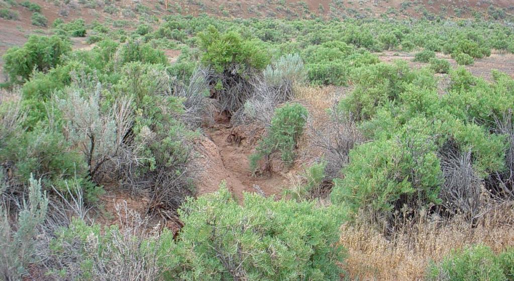
14 Photo #1 Looking West 14

15 Photo #2 Looking South 15


16 Photo #3 Looking Southwest 16

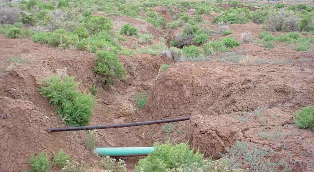
17 Photo #4 Looking Northwest (Foster Reservoir) 17

18 Photo #5 Looking Southwest 18


19 Photo #6 Looking Northeast 19