QUARTERLY STORMWATER UPDATE FLOOD CONTROL PROJECTS TONI ALGER, P.E. STORMWATER ENGINEERING CENTER ADMINSTRATOR MARCH 26, 2019
|
|
|
- Baldric Fleming
- 5 years ago
- Views:
Transcription

1 QUARTERLY STORMWATER UPDATE FLOOD CONTROL PROJECTS TONI ALGER, P.E. STORMWATER ENGINEERING CENTER ADMINSTRATOR MARCH 26, 2019
2 D a s h b o a r d Aragona Drainage Improvements, Ashville Park Drainage Improvements Phase I, Central Resort District Drainage Improvements, Chubb Lake/ Lake Bradford, Eastern Shore Drive Drainage Phase I, Sherwood Lakes Drainage Improvements, Southern Canal/Lead Ditch & Culvert Improvements, Stormwater Master Planning, Analysis and Inventory, Windsor Woods, Princess Anne Plaza, and The Lakes, 7-028, &

3 LOCATION OF PROJECTS BY DISTRICT
4 ARAGONA DRAINAGE IMPROVEMENTS, Neighborhood developed in the mid 1950s Storm drain improvements to address severe roadway flooding Project limits revised to include Sullivan Boulevard to Aragona Boulevard, Overman Avenue to the Outfall at Betty s Bottom, and Overman Avenue East of Sullivan Boulevard Total Project Cost Appropriated to Date FY19 FY20 FY21 FY22 FY23 FY24 Balance To Complete $4,400,000 $3,760,000 $640,000 4
5 ARAGONA DRAINAGE IMPROVEMENTS, FIRST QUARTER 2019 ACTIVITIES January 24, 2019 Citizen Information Meeting February 19, 2019 City Council Authorization of Acquisition of Property & Easements March 7, 2019 Environmental Permit Received July 2019 Scheduled to advertise for construction o Construction is expected to take 15 months 5
6 ASHVILLE PARK DRAINAGE IMPROVEMENTS PHASE I, new Stormwater Ponds Expand an Existing Pond Channels Connecting Ponds Regrade and Stabilize Existing Ditches Stormwater Pump Station Gated Control Structure at Flanagans Lane Ditch and Culvert Improvements at New Bridge/Sandbridge Road Intersection Total Project Cost Appropriated to Date FY19 FY20 FY21 FY22 FY23 FY24 Balance To Complete $12,000,000 $2,000,000 $7,000,000 $3,000,000 $0 6
7 ASHVILLE PARK DRAINAGE IMPROVEMENTS, FIRST QUARTER 2019 ACTIVITIES February 6, nd Submittal from Developer for Ashville Park Drainage Improvements Phase I February 8, % Plans for Permanent Pump Station, Sandbridge/ New Bridge Intersection Improvements, Final Plans for Flanagans Lane/Sandbridge Road Outfall Ditch February 12, 2019 Meeting with Owner of Princess Anne Farm Ditch property February 13, rd Submittal from Developer for Grandview Village 7
8 ASHVILLE PARK DRAINAGE IMPROVEMENTS, FIRST QUARTER 2019 ACTIVITIES March 1, 2019 Submitted Environmental Permit o Sandbridge Road/New Bridge Road Intersection project o Pump Station project March 14, 2019 Ashville Park Civic League Meeting Presentation March 19, th Meeting with US Fish & Wildlife on 100% Plans March 20, 2019 Resubmitted Environmental Permit for Sandbridge Road/New Bridge Road Intersection project 8
9 ASHVILLE PARK DRAINAGE IMPROVEMENTS, FIRST QUARTER 2019 ACTIVITIES Lake #14 Weir Weir wall structure is poured and forms stripped Intake Structures are set Crane has been demobilized Discharge piping complete Discharge channel grading and stabilization complete Roadside ditch regrading/aligning complete Box culvert installed Remaining Items Electrical and SCADA items 9
10 CENTRAL RESORT DISTRICT DRAINAGE IMPROVEMENTS, Multi-phase project to address severe roadway flooding Ultimate improvements include additional storm drains, tide gate, pump station & ocean outfall Interim Projects: 1. Replace existing 54 pipe located under 24 th Street with box culvert or bridge; estimated cost ~ $6M 2. Redirect approx. 15 ac. from 21st St and Baltic Ave. to 16th St. Pump Station; estimated cost ~ $15M Total Project Cost Appropriated to Date FY19 FY20 FY21 FY22 FY23 FY24 Balance To Complete $113,000,000 $300,000 $500,000 $112,200,000 10
11 CENTRAL RESORT DISTRICT DRAINAGE IMPROVEMENTS FIRST QUARTER 2019 ACTIVITIES Interim Project #1 February 2019 Stormwater Model Updated, Survey and Geotechnical Testing Completed Upcoming Activities April 2019 Design Alternatives Memo for 54-inch pipe replacement June % Design Plan of Selected Alternative 11
12 CHUBB LAKE/BRADFORD LAKE, Multi-phase project Storm drain improvements to alleviate roadway flooding Additional stormwater culverts under roadways Tide control devices such as mechanized sluice gates Stormwater management pond improvements Channel and ditch clearing Total Project Cost Appropriated to Date FY19 FY20 FY21 FY22 FY23 FY24 Balance To Complete $32,000,000 $1,084,100 $1,084,100 $1,084,100 $1,084,100 $1,084,100 $1,084,100 $1,084,100 $24,411,300 12
13 CHUBB LAKE/BRADFORD LAKE, FIRST QUARTER 2019 ACTIVITIES Ongoing Coordinate with Navy to open the weir gate when major rain events are forecasted February 4, 2019 Received Survey Information for the JEB Little Creek Base Design Underway for Early Implementation Projects o Dredging 780 feet of ditch from the north side of Shore Drive north to Lake Bradford 1,150 feet of ditch from Pleasure House Road (north of Shore Drive) west to Lake Bradford o Pleasure House Lake Outfall Improvements 13
14 EASTERN SHORE DRIVE DRAINAGE PHASE I, Multi-phase project Phase I includes Sections I & II Flood control drainage improvements Improvements include stormwater collection systems, tide gates & pump stations Phase I - Section I Phase I - Section II Total Project Cost Appropriated to Date FY19 FY20 FY21 FY22 FY23 FY24 Balance To Complete $72,500,000 $14,139,357 $3,200,000 $7,200,000 $8,600,000 $7,000,000 $8,000,000 $8,000,000 $16,360,643 14
15 EASTERN SHORE DRIVE DRAINAGE PHASE I, FIRST QUARTER 2019 ACTIVITIES Cape Henry Canal (CHC) Drainage Improvements design ongoing o Box culvert from Ebb Tide Road to West Great Neck Road o Side Street Outfall Improvements to Starfish Road, Ebb Tide Road & Red Tide Road o Advertise for construction late April 2019 o Estimated Project Cost $3.5M January 24, 2019 Meeting with Citrus to discuss project impacts and trail reconfiguration for safety 15
16 EASTERN SHORE DRIVE DRAINAGE PHASE I, FIRST QUARTER 2019 ACTIVITIES January-March 2019 o Coordination with Dominion Energy Transmission Unit in Richmond o Coordination with Verizon to relocate concrete duct banks February 18, 2019 Meeting with businesses adjacent to Cape Henry Trail impacted by Trail Detour Coordination with Shore Drive Phase III Roadway Improvements project 16
17 SHERWOOD LAKES DRAINAGE IMPROVEMENTS, Project to address severe roadway and property flooding Improvements include a pump station with a pipe connection between 2 lakes Total Project Cost Appropriated to Date FY19 FY20 FY21 FY22 FY23 FY24 Balance To Complete $3,000,000 $1,000,000 $2,000,000 $0 17
18 SHERWOOD LAKES DRAINAGE IMPROVEMENTS, FIRST QUARTER 2019 ACTIVITIES Ongoing Lakes pumped down to elevation 3.0 in advance of forecasted significant rainfall Interconnect Pipe project o NTP for Construction November 1, 2018 o Expected Completion July 2019 North Sherwood Lake Permanent Pump Station project o NTP for Construction January 1, 2019 o Expected Completion September 2019 January 16, 2019 Citizens Information Meeting 18

19 SOUTHERN CANAL/ LEAD DITCH & CULVERT IMPROVEMENTS, Drainage improvements to canals, lead ditches and culverts in the southern rivers watershed Improvements may include: o Pipe/culvert replacement o Ditch cleaning /regrading Construction is timed to avoid inconvenience to the agricultural community and residents Total Project Cost Appropriated to Date FY19 FY20 FY21 FY22 FY23 FY24 Balance To Complete $10,690,000 $2,350,000 $1,390,000 $1,390,000 $1,390,000 $1,390,000 $1,390,000 $1,390,000 19

20 SOUTHERN CANAL/LEAD DITCH & CULVERT IMPROVEMENTS SITE 5 Dawley Road between Pleasant Ridge Road and Beggars Bridge Creek Culvert o o o Clean Culverts Clear and Reshape/Regrade Roadside Ditches along Dawley Road Clear Beggars Bridge Creek and Farm Ditches East and West of Dawley Road Ditch Clearing along Dawley Road begins in March 2019 Environmental Permits for Beggars Bridge Creek sections are expected in July 20

21 SOUTHERN CANAL/LEAD DITCH & CULVERT IMPROVEMENTS SITE 6 Pleasant Ridge Road west of Dawley Road o o Reshape/Regrade Ditches on both sides Replace Culverts Under Pleasant Ridge Road Environmental Permits expected in April Ditch Clearing along Pleasant Ridge Road to start May 2019 Design for Culverts Underway 30% Complete 21

22 SOUTHERN CANAL/LEAD DITCH & CULVERT IMPROVEMENTS SITE 7 Intersection of Pleasant Ridge Road and Charity Neck Road o o o o Replace Culverts Under Pleasant Ridge Road Regrade the Roadway Pavement Reshape/Regrade Ditches Relocate Above Ground Utilities Design Underway 30% Complete 22

23 SOUTHERN CANAL/LEAD DITCH & CULVERT IMPROVEMENTS SITE 9 Gum Bridge Court Charity Farm Court Gum Bridge Road Between Charity Farm Court and Gum Bridge Court o o o o o Clean Existing Culvert/Regrade Ditches Culvert Replacement Widen Ditches Overlay Pavement Relocate Above Ground Utilities Design Underway 30% Complete 23
24 SOUTHERN CANAL/LEAD DITCH & CULVERT IMPROVEMENTS, FIRST QUARTER 2019 ACTIVITIES December 21, 2018 Obtained Environmental Permits for Ditch Work for Site 5 March 6, 2019 Notice to Proceed for Ditch Work for Site 5 March 7, 2019 Citizens Information Meeting Environmental Permits are in process for Sites 6, 7 & 9 Completed 30% Design for Sites 6, 7, & 9 24

25 SWM MASTER PLANNING, ANALYSIS, AND MODELING, Update the City s 31 Stormwater Drainage Basin Models Models provide drainage design parameters such as downstream water surface levels to developers for projects Models identify deficiencies and gaps in the existing stormwater infrastructure Preliminary Drainage Analysis will identify future Capital Drainage Projects in conjunction with results of Sea Level Rise study Total Project Cost Appropriated to Date FY19 FY20 FY21 FY22 FY23 FY24 Balance To Complete 25 $13,770,906 $8,070,906 $1,700,000 $800,000 $800,000 $800,000 $800,000 $800,000 $0 25
26 SWM MASTER PLANNING, ANALYSIS, AND MODELING SCHEDULE WATERSHED DRAINAGE BASIN SCHEDULED COMPLETION Lynnhaven 3 thru 8 & 30 Completed Little Creek 1 & 31 Awaiting Validation Locations Atlantic 29 Awaiting Validation Locations Elizabeth River 2 & 17 thru 22 Awaiting Validation Locations (2), August 2019 (17-22) Southern Rivers Upper West Neck 10 Completed Stumpy Lake 12 Completed Canal #1 South 9 Completed Southern 11, 16, & 23 thru 28 Awaiting Validation Locations Upper North Landing 13 thru 15 August 2019 Dates represent when there is a validated/calibrated model. Please send flooding pictures to stormpics@vbgov.com 26
27 WINDSOR WOODS, PRINCESS ANNE PLAZA & THE LAKES, 7-028, 7-050, & Neighborhoods Developed in the 1960s and 1970s Projects combined for initial analysis Needed Improvements Identified o o o o Tide Gates Pump Stations Additional Storage Increase Capacity in Stormwater Conveyance Total Project Cost Appropriated to Date FY19 FY20 FY21 FY22 FY23 FY24 Balance To Complete $353,799,994 $15,250,834 $4,500,000 $5,000,000 $9,000,000 $7,000,000 $7,000,000 $8,300,000 $297,749,160 27

28 WINDSOR WOODS PUMP STATION AND TIDE GATE LOCATION PRELIMINARY CONCEPT PLAN 28
29 WINDSOR WOODS, PRINCESS ANNE PLAZA & THELAKES FIRST QUARTER 2019 ACTIVITIES Attended Princess Anne Plaza Civic League o January 8 th, February 12 th and March 12 th February 13, 2019 Open House Public Meeting for Club House Road Drainage Project o Notified 84 property owners by letter and placed Public Notices in Beacon o Developed Club House Road Drainage Project Brochure Updated Q&A on project website to include Club House Road Project February 22, 2019 Received Final Draft Preliminary Engineering Report for Windsor Woods Web Page: Address: papww@vbgov.com 29

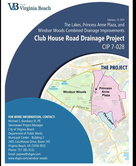

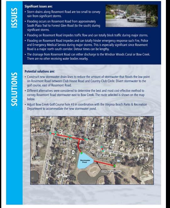

30 WINDSORWOODS, PRINCESSANNEPLAZA & THELAKES FIRST QUARTER 2019 ACTIVITIES Club House Road Drainage Project Brochure 30

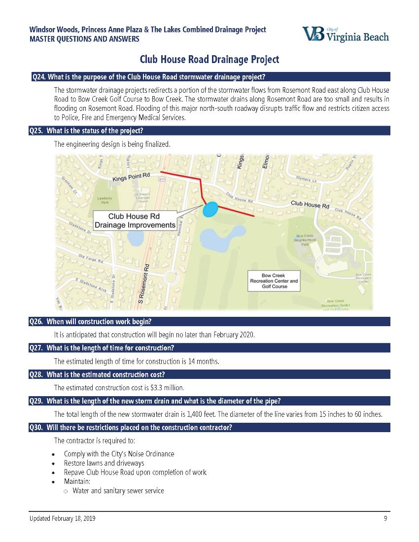
31 Finalizing Design Construction Start: No later than February 2020 Estimated Construction Cost: $3.3M CLUB HOUSE ROAD DRAINAGE IMPROVEMENTS PROJECT/FEMA GRANT PROJECT 31

32 Survey Work Completed Design in Progress Construction Start Project 1 July 2021 Projects 2 & 3 July 2022 FEMA REIMBURSEMENT PROJECTS 32

33 Estimated Total Project Cost: $6.7M WINDSORWOODSTIDE GATE/FEMA GRANT PROJECT 33

34 Environmental Permit application being reviewed by USACE and the VA DEQ. Meeting held January 17 th to discuss agency questions WINDSORWOODSTIDE GATE/FEMA GRANT PROJECT 34

35 EXAMPLE OF INTERIM PUMPING FACILITIES 35

36 DREDGING PROJECTS 36
37 WINDSOR WOODS CANAL, CIP Dredge 4,100-ft canal to restore original drainage capacity Approximately 10,900 cubic yards of dredge material Notice to Proceed June 2017 Construction Substantially Complete Estimated Total Project Cost $2M Avg. Pre-depth: 3.1 Avg. Post-depth:
38 NORTHGATE DITCH, CIP Dredge 6,000-ft canal to restore original drainage capacity Approximately 3,000 cubic yards of dredge material Notice to Proceed May 2017 Construction Substantially Complete Estimated Total Project Cost $2M Avg. Pre-depth: 1.5 Avg. Post-depth:
39 WINDSOR OAKS WEST 3, CIP Dredge 2,100-ft canal to restore original drainage capacity Approximately 3,000 cubic yards of dredge material Construction is Pending Easements Construction Complete 10 months from NTP Estimated Total Construction Project Cost $800K Avg. Pre-depth: 1.8 Avg. Post-depth:
40 DISCUSSION