National Water Model: Research to Operations
|
|
|
- Myrtle Pope
- 5 years ago
- Views:
Transcription


1 National Water Model: Research to Operations presented to Building a Weather and Water Ready Nation by Transitioning Academic Research into NOAA Operations November 1,


es")


ve")
2 Presenta)on Outline Impetus for Change Na)onal Water Model Current Capabili)es Scien)fic Gaps Research to Opera)ons Ac)vi)es CUAHSI and Summer Ins)tute NOAA Collabora)ve programs Summary 2 TOO MUCH POOR QUALITY TOO LITTLE


cipated to expand over )me")
3 Integrated Water Resources Science and Services (IWRSS): Partners and Missions Collabora've Science-Based Solu'ons to Address Societal Needs Water Information: Collects and disseminates reliable, impartial, and timely information needed to understand the Nation's water resources to minimize loss of life and property from natural disasters US Army Corps of Engineers Water Management: Strengthens our Nation's security, energizes the economy, and reduces risks from disasters Water Prediction: Provide weather, water, and climate data, forecasts and warnings for the protection of life and property and enhancement of the national economy. FEMA Response and Mitigation: Supports our citizens and first responders to ensure that as a nation we work together to build, sustain, and improve our capability to prepare for, protect against respond to, recover from and mitigate all hazards IWRSS Partnership an)cipated to expand over )me IWRSS Partnership will expand over time 3

cal data Image credit: AP")
4 Growing Water Stakeholder Informa)on Needs u Key Stakeholder Priori)es u Flooding u Drought u Water Availability u Water Quality u Climate Change u Need integrated understanding of near- and long-term outlook and risks u Provide consistent, high resolu'on ( neighborhood level ) analyses, predic'ons and data to address cri)cal unmet informa)on and service gaps u Transform informa)on into ac'onable intelligence by linking hydrologic, infrastructural, economic, demographic, environmental, and poli)cal data Image credit: AP Photo/David J. Phillip 4
 operational [V1.0 July 2016] ² Street Level water forecasts for 2.")
5 Addressing Stakeholder Needs Multi-Year Strategic Science and Services Plan Office of Water Prediction National Water Center FY Core Capability Centralized Water Forecasting National Water Model (NWM) operational [V1.0 July 2016] ² Street Level water forecasts for 2.7 million stream reaches ² Expand from only flow/ stage forecasts to forecasts of full water budget ² Forecasts linked to geospatial informational to provide water intelligence FY Key Enhancement Flash Flood and Urban Hydrology Enhance NWM with nested hyperresolution zoom capability and urban hydrologic processes ² Heightened focus on regions of interest (e.g. follow storms) ² Street level flood inundation forecasts for selected urban demonstration areas ² NWC increases guidance to NWS field offices to improve consistency and enhance services for flash floods FY 17- Major Integration Integrated Water Prediction Couple NWM with marine models to predict combined effects of storm surge, tide, wave, and riverine More complete picture of coastal storm impacts ² Summit-to-sea water prediction information linked to geospatial information to assess risk and vulnerability ² New service delivery model implemented increased stakeholder engagement and integrated information ² NWC Operations Center opens and provides national decision support services and situational awareness TBD Key Enhancement Dry Side: Drought and Post-Fire Couple NWM with shallow groundwater and transport models to predict low flows, drought and fire impacts ² Add NWM processes that capture subsurface water movement and storage during dry conditions ² Add NWM ability to track constituents (e.g. sediment, contaminants, nutrients) through stream network ² New decision support services for water shortage situations and waterborne transport ² NWC Operations Center services expand to include drought and postfire decision support services TBD Major Integration Water Quality Integrate enhanced NWM with key water quality data sets, models and tools to begin water quality prediction ² Incorporate water quality data from federal and State partners into NWM ² Link NWM output to NOAA ecological forecasting operations ² New decision support services for predicting water quality issues such as Harmful Algal Blooms ² New decision support services for emergencies such as chemical spills ² NWC operations center services expand to include water quality decision support services


6 National Water Center Initial Operating Capacity: May 26, 2015 NWC has hosted more than 70 scientific meetings with over participants A Catalyst to Transform NOAA s Water Prediction Program Center of excellence for water resources science and prediction Catalyst for Enterprise Collaboration Operations Center for water resources common operating picture and decision support services

 Opera=onal forecast streamflow")
 Employs an Earth system modeling architecture")
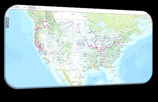
7 Na)onal Water Model Ini'al Opera'ng Capability v1.0 implemented August 16, 2016 Spa)ally con)nuous es)mates of major water cycle components (e.g., snowpack, soil moisture, channel flow, major reservoir inflows, flood inunda=on) Opera=onal forecast streamflow guidance for currently underserved loca)ons: 3,600 forecast points 2.7 million NHDPlus river reaches (700 fold increase in spa=al density) Employs an Earth system modeling architecture that permits rapid model evolu=on of new data, science and technology (i.e. WRF-Hydro) Ongoing development of Water Resource Evalua)on Service (WRES) and Data Service (WRDS) to support implementa=on efforts Current NWS River Forecast Points overlaid with NWM Stream Reaches


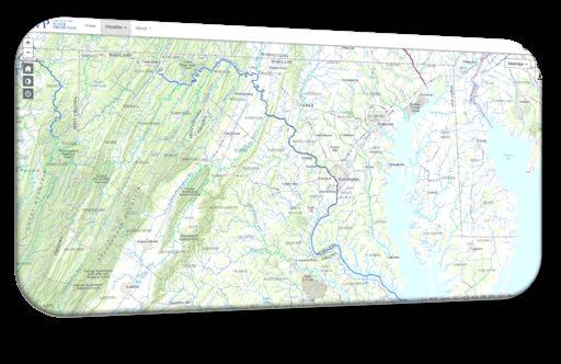

8 NWM Provides Multi-Scale Hydrologic Forecast Guidance National Regional Stream-scale 8


on Ponded Water")
on Flash Flood Watch")
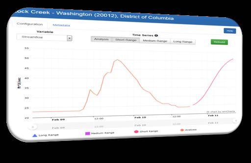
9 Beyond Streamflow Addi)onal NWM Hydrologic Guidance NWM Gridded Analyses for 23Z on April 29 th, 2017 Hourly Precipita)on Depth to Satura)on Ponded Water Surface Layer Soil Moisture Satura)on Flash Flood Watch Flash Flood Warning
ng for Anthropogenic Processes Applica)on of Hydro-informa)cs for Integra)on of Geospa)al Data and Development of Decision Support Tools Model component")
10 Future S&T Challenges/Limits to Improving Water Prediction Capability and Related Services Expanded set of water variable observa)ons and assimila)on strategies Physical Process Understanding Model Enhancement and Community Development Accoun)ng for Anthropogenic Processes Applica)on of Hydro-informa)cs for Integra)on of Geospa)al Data and Development of Decision Support Tools Model component and forecast evalua)on Quan)fica)on and Communica)on of Uncertainty and Risk System Interoperability and Data Synchroniza)on High Performance Compu)ng Resources
tute Year one included 44 graduate students from 19 Universi)es, June - July 2015")

on maps u=lizing NWM output Engaged social scien)sts and stakeholders from the Fire, Police")
es, June - July 2017 Refine the recently developed process to create flood inunda)on maps na=onally")
11 NWC Annual Innovators Program: Accelerate R2O Partnership with the academic community via Interagency Agreement with the NSF and CUAHSI to host a compe==ve Summer Ins)tute Year one included 44 graduate students from 19 Universi)es, June - July 2015 Demonstrated ability to simultaneously model the en)re con)nental United States river network at high spa=al resolu=on, in near real-=me for 2.7 million stream reaches Year two included 34 graduate students from 21 Universi)es, June - July 2016 Demonstrated the ability to generate flood inunda)on maps u=lizing NWM output Engaged social scien)sts and stakeholders from the Fire, Police and Emergency Management Communi)es to explore ways to best communicate water informa=on Year three includes 34 graduate students from 25 Universi)es, June - July 2017 Refine the recently developed process to create flood inunda)on maps na=onally in real =me Develop a strategy for a hyper-resolu)on nest of the NWM Improve the communica)on of water resources informa)on
-sensor precipita)on algorithms Hyper-Resolu)on Modeling Low flow channel process improvement UCAR COMET Coopera)ve and Partner Grants Flood Inunda)on technique Hydro-Informa)cs")
12 Leveraging NOAA Research to Opera)ons USWRP JTTI Con)nued demonstra)on within FFaIR Radar based stream-flow gage Improved lake hydrology and oconus hydrography data Evapotranspira)on demand data sets Enhancements to mul)-sensor precipita)on algorithms Hyper-Resolu)on Modeling Low flow channel process improvement UCAR COMET Coopera)ve and Partner Grants Flood Inunda)on technique Hydro-Informa)cs and Anthropogenic process Hydraulic analysis Developing rela)onship with NOAA Office of Educa)on Coopera)ve Science Centers
, peak streamflow, )me to peak streamflow, and )me to recession (to bankfull).")
13 Experimental NWM-based Guidance for Hurricane Harvey Time to High Flow based upon Short-Range (HRRR Forced) NWM Configura)on Provided TDEM forecasts of streamflow, streamflow anomaly, )me to bankfull (i.e., full river channel), peak streamflow, )me to peak streamflow, and )me to recession (to bankfull). Rou)ne coordina)on calls between OWP, NWC, WGRFC, SR ROC, WPC, and USACE

14 NWM Rainfall Streamflow Anima)on for Hurricane Harvey Overall extreme streamflow pagern forecast several days in advance by NWM
nue to inform future science/service development ac)vi)es Deliver comprehensive, integrated ac)onable water predic)ons/intelligence More than streamflow --")
ng environment Renewed and sustained engagement with the research community is essen)al to rapidly evolve the system New")
15 Lever NOAA s Water Services are Evolving We are building a founda)on for change Con)nental scale modeling approach producing consistent, neighborhood-level informa)on to address growing stakeholder needs Stakeholder input will con)nue to inform future science/service development ac)vi)es Deliver comprehensive, integrated ac)onable water predic)ons/intelligence More than streamflow -- spa)ally-con)nuous forecasts of soil moisture, evapotranspira)on, runoff, snow water equivalent and other parameters Implemen)ng State-of-the-Art Technical Approach Water resources predic)on through state-of-the-science earth system modeling in a high performance compu)ng environment Renewed and sustained engagement with the research community is essen)al to rapidly evolve the system New Organiza)on, Cornerstone Facility and Philosophy Office of Water Predic)on/Na)onal Water Center Collabora)ve, cross-noaa, interagency, academic partnerships Vision without ac)on is merely a dream. Ac)on without vision just passes the )me. Vision with ac)on can change the 15 world. Joel A. Barker
16 BACKUP


17 Na)onal Academy of Sciences Report, 2012 Weather Services for the Na'on: Becoming Second to None Findings Recommendations A significant gap exists between the state of hydrologic science and current hydrologic operations The level of sophistication, representation of processes, and characterization of uncertainties in external research and operational communities outpace those used in NWS hydrology operations Improve pathways for collaboration & accelerate R2O Establish a hydrologic prediction testbed as part of the National Water Center Implement a consistent framework for hydrologic prediction skill assessment NWS Hydrologic Forecasters are extensively in the forecast loop Transition RFC forecasters to over the loop enabling a shift in focus to model and product development, forecast interpretation, and decision support Lack of skill in modern computational programming, construction and use of new Earth System Models, current hydrologic data assimilation methodologies, and preparation and interpretation of meaningful ensemble predictions Hydrologist staff require re-education and continual retraining to enable adoption of state-of-the-art prediction methodologies Instill evolutionary culture Add value to hydrologic forecasts through the use of more advanced models, data assimilation and employment of more sophisticated ensemble techniques 17
 National")


18 1. NWM Forcing Engine (1 km grid) National Water Model Initial Operating Capability: Model Chain NWM uses NCAR supported community WRF-Hydro system NWM: WRF-Hydro: 2. NoahMP LSM (1 km grid) 2-way coupling 3. Terrain Routing Module (250 m grid) 4. NHDPlus Catchment Aggregation (2.7M unique catchments and river reaches) 5. Channel & Reservoir Routing Modules Guidance Data
ons Cycling Forecast Forcing")

 30 days Downscaled and")
ons All configura)ons include reservoirs")
19 Analysis & Short-Range Na)onal Water Model V1.1 Analysis and Forecast Cycling Configura)ons Cycling Forecast Forcing Outputs Hourly 18 hours MRMS QPE Downscaled HRRR/RAP Blend 1km Land States, 250m Sfc Routed Water, NHDPlus Streamflow Medium-Range 4 x Day 10 days Downscaled GFS 1km Land States, 250m Sfc Routed Water, NHDPlus Streamflow Long-Range Daily Ensemble (16 members) 30 days Downscaled and Bias- Corrected CFS 1km Land States, NHDPlus Streamflow Analysis assimilates ~7,000 USGS Observa)ons All configura)ons include reservoirs (1260 water bodies parameterized with level pool scheme) 19
on for the 21 st Century Leverages the Na)onal Water Center to provide next-genera)on, science-based water informa)on and decision support services.")
20 NOAA Water Initiative Overarching Goal: Transform water information service delivery to better meet and support evolving societal needs User-Oriented, informed by Regional and Na)onal Conversa)ons on Integrated Water Informa)on for the 21 st Century Leverages the Na)onal Water Center to provide next-genera)on, science-based water informa)on and decision support services. Calls for collabora)on across federal agencies and with partners outside government Released in December 2016 hgp://


cs")
21 NOAA Water Initiative Key Objectives Improve Modeling & Prediction Enhance Water-Related Observations Accelerate Research & Development Strengthen Decision Support Tools Informed by Social Science and Enabled by Hydroinforma)cs Enhance Service Delivery
on on exisi)ng and maximum possible flood")
22 Experimental NWM-based Guidance for Hurricane Harvey Flood Inunda)on Maps based upon the NWM Analysis and 5-Day Forecast Houston Houston Maps supported emergency management efforts to stage supplies in nonflooded areas and to target relief efforts TDEM needed informa)on on exisi)ng and maximum possible flood extent