Using high flows from, or in anticipation of, rainfall or snowmelt, for managed aquifer recharge on agricultural lands and working landscapes
|
|
|
- Paulina Hart
- 5 years ago
- Views:
Transcription
1

2 Using high flows from, or in anticipation of, rainfall or snowmelt, for managed aquifer recharge on agricultural lands and working landscapes
3 More competition over surface water storage Potential surface water reduction in storage due to climate change more rain than snow Overall concerns regarding sustainability SGMA

4 Study Purpose Proof of concept study that will investigate the Flood-MAR concepts & implementation factors Test theories related to research themes presented in the white paper Identify and overcome barriers and constraints Policy Legal Technical Stakeholder willingness
5 Study Purpose Integrates surface and groundwater analyses Document the process of planning, modeling, and analyzing a Flood-MAR project of this scale Multi-benefit analysis and economic assessment Water Supply Water Quality Flood Risk Groundwater Recharge Ecosystem Enhancement Socioeconomic

6 Flood risk reduction * Drought preparedness * Aquifer replenishment Ecosystem enhancement * Groundwater remediation/water quality * Working landscape preservation and stewardship Climate change adaptation Recreation and aesthetics * * Public benefits defined in Proposition 1
7 Study Procedure Analyze a range of assumptions to understand the benefits that may be possible with various levels of participation and investment Analyze and screen many potential scenarios down to three scenarios per level of analysis Analyze climate change using a vulnerability assessment methodology

8 Fact Sheet White Paper Draft Research & Data Development Framework Convening Research Advisory Committee Merced River Watershed Reconnaissance Study


9 All operation rules transferred to Lake McClure Implemented flow and snowmelt scripts
10 Technical Analyses Early 2019 Technical Memos Spring 2019 Draft Report Summer 2019

11 Partnership with DWR 3 Studies: 1- Reservoir Reoperation 2- Potential Diversions 3- Expected Recharge MIDH 2 O MID Hydrology and Hydraulics Optimization Program GRAT Groundwater Assessment Tool Overcoming Barriers: Work with the State Water Resources Control Board to Overcome Inherent Restrictions Further Modernize Facility to act for Water Supply and Flood Control Simultaneously Partnerships: SGMA, etc.
12 SWRCB- > 50% Reduction in Surface Water Diversion SGMA - > 50% Reduction in Groundwater Extraction by 2040
13 Hydrology, Water Sources and Availability Land Use & Crop Resiliency Site Suitability, Soil Characteristics & Groundwater Recharge Potential Water Rights (both surface & groundwater) Delivery Conveyance Capability Infrastructure Requirements Financing Environmental Permitting & Documentation Forecasting Timing, flows, volumes Program Administration & Coordination

14 Proof of concept study that will investigate the Flood-MAR concepts & implementation factors Test theories related to research themes presented in the white paper Identify and overcome barriers and constraints Policy Legal Technical Stakeholder willingness
15 Hydrology, Water Sources and Availability Land Use & Crop Resiliency Site Suitability, Soil Characteristics & Groundwater Recharge Potential Water Rights (both surface & groundwater) Delivery Conveyance Capability Infrastructure Requirements Financing Environmental Permitting & Documentation Forecasting Timing, flows, volumes Program Administration & Coordination
16 MIDH2O will provide forecast for real-time flows at Merced River and Merced Streamgroup. Model can be used to manage flows for Flood-MAR and alert users of capturing availability. Model under development will include reservoirs, canals, and creeks.
17 Advance storm warning Quantification of flows Reservoir stages and outflows Spatial distribution of flows at diversion points Timing and volume of flows Determine occurrence of 90 percentile of stream flow Diversions quantity, timing, duration, local flooding concerns, etc.


 CASGEM")
18 Components Under Construction to Optimize Flood-MAR in Merced NEW EXCHEQUER DAM - HEC-ResSim MIDH2O Dam Operations Generation Regulation MERCED RIVER - HEC-RAS Water Surface Profiles Temperature Sediment Transport UPSTREAM WATERSHED HEC-HMS Water Supply Snowmelt Forecast Lake Inflows IRRIGATION SYSTEM GROUNDWATER ArcGIS Irrigation Data Model HEC-RAS (irrigation system) System Deliveries & Conveyance Losses IWFM2015 (groundwater model) CASGEM Monitoring Water Quality

19 HEC-RTS HEC-DSS HEC-HMS HEC-RAS HEC-ResSim
 CWMS is server based and uses Oracle Database. HEC-RTS is PC based and uses HEC-DSS.")
20 Supports standard HEC models and can be extended to support other models and data processing tasks Provides access to native model interfaces for data editing and display Deployed to over 35 USACE district and division offices * UASCE version: Corps Water Management System (CWMS) CWMS is server based and uses Oracle Database. HEC-RTS is PC based and uses HEC-DSS.
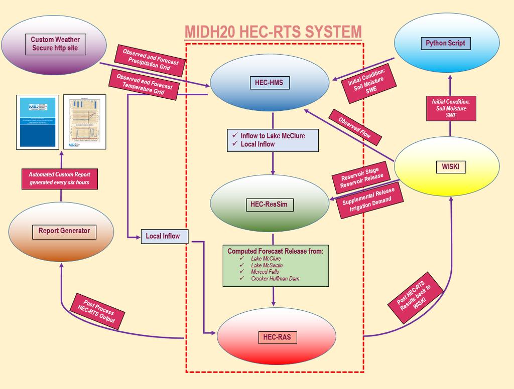
21
22
 Upper watershed in Yosemite National")
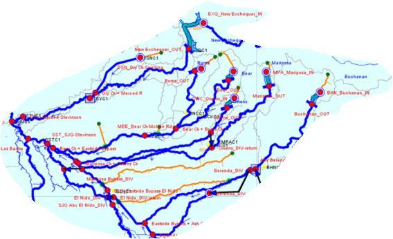
23 Tributary of San Joaquin River Drainage Area: 1,267 square miles (1,037 square miles at New Exchequer Dam) Elevation Range: 52 13,090 ft (535 square miles above 5,000 feet) Upper watershed in Yosemite National Park
24
25 METEORIGICAL FORECAST INPUT & OUTPUT The USL (Uncouple Surface Layer) Model focuses on near surface conditions GFS NAM HRRR NDFD SREF Gridded MOS GDPS HIRESW (WRF) Downscaling & Bias Correction Pre-processor Weighted Ensemble Hi-res Terrain data Clouds Precipitation etc. Observations Land surface data Tuning params USL Temperature Humidity Wind (0-100m AGL)
26

27 RESERVOIRS Bear Burns Owens Mariposa CREEKS Bear Burns Fahrens Canal Miles Owens Mariposa Duck Deadman Dutcham HMS Component Total Drainage Area: 878 square miles Elevation: 76 feet to 4,258 feet
28
29


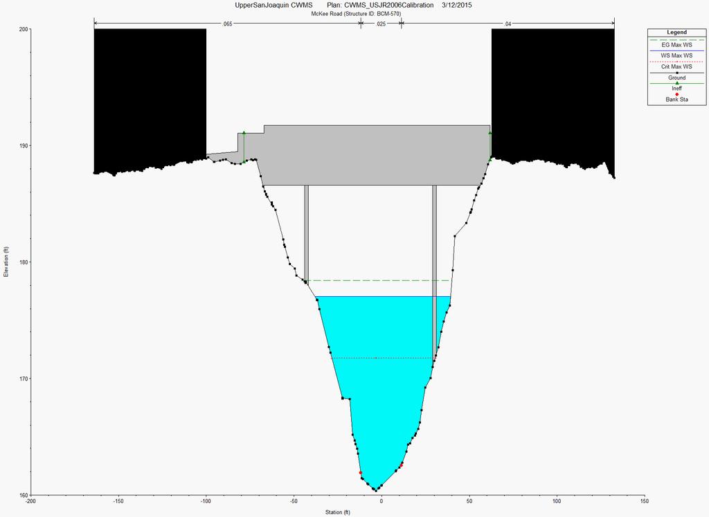
30 Sample Capability RAS
31 Hydrology, Water Sources and Availability Land Use & Crop Resiliency Site Suitability, Soil Characteristics & Groundwater Recharge Potential Water Rights (both surface & groundwater) Delivery Conveyance Capability Infrastructure Requirements Financing Environmental Permitting & Documentation Forecasting Timing, flows, volumes Program Administration & Coordination
32