Southern Avenue Bus Garage Replacement
|
|
|
- Philomena Marshall
- 5 years ago
- Views:
Transcription


1 WMATA Task Order# 11-FQ10065-MCAP-02 November 2012
2 ABSTRACT WASHINGTON METROPOLITAN AREA TRANSIT AUTHORITY SOUTHERN AVENUE BUS GARAGE REPLACEMENT 2012 ENVIRONMENTAL EVALUATION The Washington Metropolitan Area Transit Authority (WMATA) is considering the replacement of the existing Southern Avenue Bus Garage, located at the intersection of Southern Avenue and Marlboro Pike, in the area of Prince George s County, Maryland, that borders the District of Columbia. The replacement of the Southern Avenue Bus Garage would enable the continuation and improvement of bus service to communities throughout the District of Columbia and the southern portion of Prince George s County by accommodating modern Metrobuses and providing for recent and future increases in system capacity. This action would further the vision and existing plans adopted by WMATA by supporting Metrobus ridership growth and network expansion. In 2009, WMATA undertook a planning effort to evaluate the potential expansion of the existing Southern Avenue Bus Garage. Before planning was complete, WMATA received an unsolicited proposal from a private developer offering a new possible location for replacing the Southern Avenue Bus Garage. After receiving this proposal, WMATA posted an open Request for Proposals (RFP) and received an additional proposal. During 2011, WMATA worked with the two proposers to develop and evaluate two alternative sites to the existing Southern Avenue Bus Garage. Both sites and a rebuild-in-place option for the existing Southern Avenue Bus Garage were evaluated in an Environmental Assessment (EA). The EA was released to the public for comment in June During that comment period, a public hearing was held. WMATA received numerous comments on each alternative. Since that time, WMATA has continued to work with the proposers to further refine the proposed sites and program requirements. Due to changes during the last year, WMATA has prepared this (2012 EE) to document the impacts of the revised alternatives. This 2012 EE documents the following changes that have occurred since the publication of the June 2011 EA: Changes in the program requirements; Changes to Site A (Rena Road); Changes to Site C (Rebuild in Place); and Site B is no longer being considered. This 2012 EE presents the evaluation of each alternative and potential associated impact on the built and natural environment, as appropriate. A public hearing on the 2012 EE will be held December 17, 2012, at 7:00 pm, at Andrew Jackson Academy, 3500 Regency Parkway, Forestville, MD 20747, to provide citizens and agencies an opportunity to comment on the alternatives and their anticipated impacts. Comments may be made orally at the public hearing or submitted in writing. Written comments must be submitted to the Board Secretary, Washington Metropolitan Area Transit Authority, 600 5th Street, NW, Washington, DC Following close of the comment period, a Public Hearing Report will be prepared to document and respond to comments received at the hearing and during the comment period. Additional information is available by contacting: Mr. Jim Ashe WMATA 600 5th Street, NW Washington, DC (202) November 2012
3 Table of Contents 1.0 Introduction Purpose and Need for the Project Existing Facility Site Background and Description Metrobus and Existing Facility Operations Proposed Action Project Alternatives Purpose and Need of the Proposed Action Purpose of the Need for the WMATA Program Requirements Scope of the Revised Environmental Assessment Organization of the Environmental Evaluation Alternatives Considered Alternatives Previously Considered No Build Alternative Build Alternatives Build Alternative A (Rena Road) Build Alternative C (Rebuild in place Southern Avenue) Affected Environment and Environmental Consequences Transportation Introduction Methodology No Build Alternative Alternative A Zoning Introduction Methodology No Build Alternative Alternative A Alternative C Land Acquisitions and Displacements Introduction Methodology No Build Alternative Alternative A Alternative C Neighborhoods and Community Resources Introduction Methodology No Build Alternative Alternative A Alternative C Environmental Justice Introduction Methodology No Build Alternative Build Alternative A Build Alternative C Comparison of Disproportionately High Adverse Effects of Build Alternatives Consistency with Local Plans November 2012 i
4 3.6.1 Introduction Applicable Adopted Local Planning Documents No Build Alternative Alternative A Alternative C Cultural Resources Introduction Methodology No Build Alternative Alternative A Alternative C Parklands Introduction Methodology No Build Alternative Alternative A Alternative C Air Quality Introduction Methodology No Build Alternative Alternative C Noise and Vibration Introduction Methodology No Build Alternative Build Alternative A Build Alternative C Vibration Water Quality Introduction Methodology No Build Alternative Alternative A Alternative C Coastal Zones Introduction Methodology Existing Conditions Environmental Consequences Potential Mitigation Water Resources Introduction Wetland Delineation Methodology Waters of the U.S. Methodology Navigable Waterway Methodology No Build Alternative Alternative A Alternative C Floodplains Introduction Methodology No Build Alternative Alternative A Alternative C Ecosystems and Endangered Species November 2012 ii
5 Introduction Methodology No Build Alternative Alternative A Alternative C Soil and Geologic Resources Introduction Methodology No Build Alternative Alternative A Alternative C Contaminated Materials Introduction Methodology No Build Alternative Alternative A Alternative C Secondary and Cumulative Impacts Introduction Methodology No Build Alternative Alternative A Alternative C Construction Impacts Introduction Environmental Consequences Mitigation Measures Agency Coordination and Public Involvement Introduction Agency Correspondence Public Involvement Public Hearing List of Acronyms and Terms Acronyms Glossary of Terms List of References References Data Resources List of Figures Figure 1-1: Existing Southern Avenue Bus Garage Figure 1-2: WMATA Bus Maintenance Facilities Figure 1-3: Location of Build Alternatives Figure 1-4: Build Alternatives Figure 2-1: Location of Build Alternative A Figure 2-2: Alternative A within Planned Andrews Federal Campus Figure 2-3: Build Alternative A Proposed Concept Plan Figure 2-4: Location of Build Alternative C Figure 2-5: Alternative C Acquisitions Figure 2-6: Build Alternative C Proposed Concept Plan Figure 3-1: Transportation Network Figure 3-2: Traffic Study Intersections November 2012 iii
6 Figure 3-3: Existing Zoning Figure 3-4: Neighborhoods and Community Facilities Figure 3-5: Environmental Justice Comparison Areas Figure 3-6: Environmental Justice Figure 3-7: Build Alternative A Cultural Resources Figure 3-8: Public Parklands Figure 3-9: Air Quality Monitoring Sites Figure 3-10: Location of Noise Receptors Figure 3-11: Maryland Coastal Zone Figure 3-12: Alternative A Water Resources and Floodplain Figure 3-13: Prime Farmland Figure 3-14: Topography Figure 3-15: Alternative A within Planned Andrews Federal Campus List of Tables Table 1-1: WMATA Active Bus Garages Table 1-2: Southern Avenue Bus Garage Problems Table 3-1: No Build Alternative Intersection Conditions Table 3-2: Alternative A Intersection Conditions Table 3-3: Alternative C Intersection Conditions Table 3-4: Proposed Property Acquisitions Build Alternative C Table 3-5: Community Resources near the No Build and Build Alternatives Table 3-6: Minority Populations Table 3-7: No Build Study Area Comparison of Environmental Justice Population Characteristics Table 3-8: Alternative A Study Area Comparison of Environmental Justice Population Characteristics Table 3-9: Alternative C Study Area - Comparison of Environmental Justice Population Characteristics Table 3-10: Consistency with Local Plans Table 3-11: Identified Parklands Table 3-12: Ambient Air Quality in the Region Table 3-13: FTA Land-Use Categories and Noise Metrics Table 3-14: WMATA Criteria for Noise from Transit System Ancillary Facilities (dba) Table 3-15: Baseline Noise Levels Measured at Representative Locations in the Vicinity of the Proposed Bus Garage (in dba) Table 3-16: FTA Noise Impact Assessment at Select Receivers for Build Alternatives Table 3-17: WMATA Noise Impact Assessment at Select Receivers Table 3-18: Soil Characteristics No Build Alternatives Table 3-19: Soils Characteristics Build Alternative A Table 4-1: Agency Correspondence Table 4-2: Public Meetings and Outreach Appendices Appendix A Appendix B Appendix C Appendix D Agency Correspondence Transportation Improvement Program OMITTED Phase I Environmental Site Assessments November 2012 iv
7 1.0 Introduction Washington Metropolitan Area Transit Authority (WMATA or Metro) is considering the replacement of the existing Southern Avenue Bus Garage, located at the intersection of Southern Avenue and Marlboro Pike, in the area of Prince George s County, Maryland, that borders the District of Columbia. The replacement of the Southern Avenue Bus Garage will enable the continuation and improvement of bus service to communities throughout the southern portion of Prince George s County and the District of Columbia by accommodating modern Metrobuses and providing for recent and future increases in system capacity. This action would further the vision and existing plans adopted by WMATA by supporting Metrobus ridership growth and network expansion. In 2009, WMATA undertook a planning effort to evaluate the potential expansion of the existing Southern Avenue Bus Garage. Before planning was complete, WMATA received an unsolicited proposal from a private developer offering a new possible location for replacing the Southern Avenue Bus Garage. After receiving this proposal, WMATA posted an open Request for Proposals (RFP) and received an additional proposal. During 2011, WMATA worked with the two proposers to develop and evaluate two alternative sites to the existing Southern Avenue Bus Garage. Both sites and a rebuild-in-place option for the existing Southern Avenue Bus Garage were evaluated in an Environmental Assessment (EA). The EA was approved by FTA and released to the public for comment in June During that comment period, a public hearing was held. WMATA received numerous comments on each alternative which are available in the 2011 Public Hearing Report. Since that time, WMATA has continued to work with the proposers to further refine the proposed sites and WMATA program requirements. Due to changes during the last year, WMATA has prepared this (2012 EE) to document the changes to the project since the June 2011 EA. These changes are listed below: WMATA Program Requirements: Change in facility capacity requirements (facility should have the capacity to accommodate a minimum of 150 Metrobuses and the ability to expand up to 250 Metrobuses); and Facility no longer requires a Compressed Natural Gas fueling facility. The WMATA program requirements changed due to the completion of the Shepherd Parkway Bus Garage, which opened in September With the opening of this facility, WMATA now has CNG maintenance and fueling capacity that meets or exceeds their projected CNG fleet needs. Also, as result of the opening of this new facility, WMATA has changed the current bus distribution to some of its facilities, including Southern Avenue. Southern Avenue was documented in the previous EA (June 2011) as servicing 130 buses; it now services 75 buses. Site A (Rena Road): The site no longer accommodates a CNG fueling facility, per the changes to the program requirements; The Andrews Federal Campus industrial park has been approved by Prince George s County; The site has been cleared, grubbed and graded (it was previously documented in the 2011 EA as a wooded, undeveloped sites); The Primary entrance to the site relocated from Rena Road to Forestville Road; Reconfigured the proposed WMATA site footprint to better accommodate the relocated entrance; Relocated emergency access road from the previous proposed extension of Ames Street to an emergency access road that would be accommodated within the larger Andrews Federal Campus and out to Forestville Road via the proposed industrial access road. Site B (Westphalia Road): The proposer for Site B (Westphalia Road) has withdrawn its proposal and the site is no longer being considered for the replacement of the Southern Avenue Bus Garage. November
8 Site C (Southern Avenue): Changed site plan to accommodate the minimum of 150 Metrobuses; Removed the CNG fueling facility; Reduced the footprint of the rebuild alternative to minimize property impacts; and Relocated the emergency access point from an access point to Marlboro Pike to Quinn Street 1.1 Purpose and Need for the Project Existing Facility Site Background and Description The existing facility is approximately 6 acres in size and is located at the intersection of Southern Avenue and Marlboro Pike in Prince George s County, Maryland. The garage was built in 1922 and owned by a private bus company for nearly half a century. In 1973, WMATA acquired the facility through its purchase of multiple private bus companies operating in the Washington metropolitan area. In 2000, WMATA refurbished the facility. The existing facility, shown in Figure 1-1, is surrounded by a variety of land uses, including commercial, institutional, and residential. Adjacent to the facility s northern boundary is vacant retail space and surface parking in Green Hill Plaza, as well as the Free Gospel Deliverance Temple. Abutting the facility s western boundary are businesses between Pear and Quinn Streets, and directly east of the facility is the Coral Hills Shopping Center. Residences are located along the southern boundary of the facility. The garage includes a single maintenance building that extends from Southern Avenue to Boones Hill Road as well as asphalt-paved employee parking and bus storage parking. Within the maintenance building are the fueling, fare box collection and washing facilities, as well as maintenance bays, offices, and a bus operators lounge. The westernmost portion of the building, adjacent to Southern Avenue, is generally unoccupied. While Boones Hill Road is used as an entrance and exit for all Metrobuses, the access road is also utilized by Metrobuses maneuvering from their parked positions to the western portion of the maintenance building. An emergency entrance/exit is located at the end of Pear Street Metrobus and Existing Facility Operations As of September 2012, WMATA s active revenue fleet consists of approximately 1,500 Metrobuses. These buses serve a population of 3 million through 319 routes on 174 bus lines. As shown in Table 1-1 and Figure 1-2, WMATA maintains ten bus garages located throughout Washington metropolitan area. Of these garages, the Southern Avenue Bus Garage is one of the oldest and has one of the lowest capacities. Table 1-1: WMATA Active Bus Garages Garage Year Built Capacity Bladensburg Northern Western Landover Montgomery Southern Avenue Four Mile Run Royal Street West Ox Shepherd Parkway SYSTEM TOTAL CAPACITY 1,774 Source: WMATA September 2012 November


9 Figure 1-1: Existing Southern Avenue Bus Garage November
10 As the WMATA 2010 Metrobus Fleet Plan acknowledges, the majority of Metro s older garages, which are located in the District of Columbia and inner suburbs and serve the core Metrobus market, are currently at or near capacity. Generally, the newer garages in the outer suburbs have excess capacity, but provide less service given the distance from the bus routes. Older bus garages, such as the Southern Avenue Bus Garage, lack desired maintenance capabilities and require intensive upkeep and investment in buildings, mechanical equipment, and electrical systems. Because the existing infrastructure has not been updated to accommodate modern buses, buses with new technological features cannot be stored or maintained at the garage 1.2 Proposed Action The proposed action is to construct and operate a new WMATA bus garage that would replace the existing Southern Avenue Bus Garage on its current site or at another identified site to accommodate more storage capacity and incorporate modern features to service modern buses Project Alternatives Two build alternatives are now being considered for the proposed replacement of the Southern Avenue Bus Garage. See Figure 1-3 for a location map of the two sites and Figure 1-4 for the boundaries of each alternative. Alternative A (Rena Road) Alternative A is approximately 35 acres in size, and is located northwest of the Joint Base Andrews Naval Air Facility and southwest of the intersection of Suitland Parkway and the Capital Beltway (I-95/I-495). Site A is located within five miles of the existing garage in Prince George s County. This site would be part of a larger, planned industrial park known as Andrews Federal Campus that is beginning construction. The site proposed for the WMATA facility is currently graded, grubbed and cleared. The overall development of the Andrews Federal campus was not evaluated in the previous EA or this Revised EA. Alternative C (Southern Avenue) Alternative C would rebuild the existing facilities at Southern Avenue on approximately 7 acres. The rebuild would require that the existing facility be closed during construction. All current functions would be moved to the Shepherd Parkway Bus Garage temporarily until construction is completed. November


11 Figure 1-2: WMATA Bus Maintenance Facilities November


12 Figure 1-3: Location of Build Alternatives November


13 Figure 1-4: Build Alternatives November
14 1.3 Purpose and Need of the Proposed Action Purpose of the The purpose of the Proposed Action is to provide a replacement of the Southern Avenue Bus Garage that would provide a cost-effective maintenance, operations, and storage facility that supports existing and modern bus technologies and provides additional capacity within the existing Southern Avenue Bus Garage service area Need for the The existing Southern Avenue Bus Garage site and facility presents many problems, including aging and outdated infrastructure, operational challenges, and inability to meet the program requirement of serving a minimum of 150 Metrobuses. These issues are summarized in Table 1-2. Therefore, an updated bus garage is necessary to advance the vision and existing plans adopted by WMATA by addressing WMATA s system-wide goal to support ridership growth and network expansion. Table 1-2: Southern Avenue Bus Garage Problems Problem Description Aging and outdated infrastructure On-site operational challenges Built in 1922, refurbished in 2000 Serves only standard diesel buses Not able to accommodate the technology of modern buses Maneuvering and circulation difficulties due to facility layout Inability to meet specified minimum program requirement of 150 Metrobuses Current facility can only accommodate up to 103 Metrobuses (as shown in Table 1-1) Current facility cannot support ridership growth and network expansion The Southern Avenue Bus Garage replacement is needed to provide for recent and future increases in system capacity, new technology, and more efficient maneuvering and circulation in and around the facility. Because of the current facility s demonstrated operational deficiencies, the Southern Avenue Bus Garage is not currently considered cost-effective for operations. As WMATA seeks to achieve its systemwide goals of supporting ridership growth and network expansion, it will become even more important that its bus garages--particularly those which serve the core Metrobus market--can accommodate Metrobuses in larger volumes as well as those of modern varieties. However, because the existing Southern Avenue Bus Garage cannot physically support a growing and changing bus fleet, it cannot help meet these system-wide goals. Therefore, the replacement of the Southern Avenue Bus Garage is necessary to address the current facility s deficiencies and to promote WMATA s system-wide goals and general operations. 1.4 WMATA Program Requirements The new facility would have the capacity to accommodate a minimum fleet of 150 Metrobuses with the possibility of expanding the facility up to 250 Metrobuses. In addition to parking and storage facilities for the Metrobuses, other program requirements in the new facility include the following: Maintenance and administrative building; Employee parking; Service lane facility where fueling, washing, and fare box collections are conducted; Perimeter and other landscaping; Security fencing or other security measures; and Storm water management measures. November
15 1.5 Scope of the Revised Environmental Assessment This Environmental Evaluation has been prepared to support a WMATA Compact public hearing. WMATA s Compact requires that the Board, in amending the mass transit plan, consider current and prospective conditions in the transit zone should the project be built. The transit zone includes the Prince George s County/Southeast District of Columbia area around the site and considerations include, without limitation, land use, population, economic factors affecting development plans, existing and proposed transportation and transit facilities, any dislocation of families or businesses; preservation of the beauty and dignity of the DC Metro Area; factors affecting environmental amenities and aesthetics, and financial resources. The mass transit plan encompasses, among other things, transit facilities to be provided by WMATA, including stations and parking facilities, and the character, nature, design, location and capital and operating cost thereof. The mass transit plan, in addition to designating the design and location of transit facilities, also provides for capital and operating expenses, as well as various other factors and considerations, which, in the opinion of the Board, justify and require the projects therein proposed all as more particularly set forth in WMATA s Compact. 1.6 Organization of the Environmental Evaluation The environmental assessment is organized into five chapters: Chapter 1 provides an introduction to the project and description of the purpose and need for the project; Chapter 2 presents a detailed description of the proposed action, including alternatives, that would address the purpose and need; Chapter 3 presents the existing environmental conditions potentially affected by the project, the environmental impacts that may result from implementation of the project, and the mitigation measures to address those impacts considered to be adverse; Chapter 4 presents WMATA s public and agency consultation and coordination activities for the project; Chapter 5 provides a list of acronyms and terms used in the 2012 EE; and Chapter 6 provides a list of references used in preparing the 2012 EE. November
16 2.0 Alternatives Considered This chapter provides descriptions of the alternatives under consideration and evaluation in this 2012 Environmental Evaluation (2012 EE). In total, three alternatives are presented, including the No Build Alternative and two Build Alternatives. The Build Alternatives include two separate locations for the construction and operation of a new WMATA bus garage that would replace the existing WMATA Southern Avenue Bus Garage. Each alternative is described in detail in Sections 2.1 and 2.2 below. A preferred alternative will be selected after the public hearing. 2.1 Alternatives Previously Considered In the June 2011 EA, an additional build alternative, Site B (Westphalia Road) was presented and evaluated as part of the EA. This alternative was also presented as part of the public hearings held in July 2011 on the project. Since that time, the proposer for Site B decided to withdraw its proposal from consideration. Therefore, Site B is not documented in this 2012 EE. 2.2 No Build Alternative The No Build Alternative provides a baseline against which a comparison of each alternative can be made. Under a No Build Alternative, minor improvements and maintenance of facilities and equipment can be accommodated. The existing Southern Avenue Bus Garage is located near the intersection of Southern Avenue and Marlboro Pike in Prince George s County, Maryland. The current site is approximately 6 acres in size and is situated in an urban setting, surrounded by commercial and residential uses. Figure 2-1 shows the location of the existing Southern Avenue Bus Garage. The existing facility was built in 1922 and was last rehabilitated in The site has a single maintenance building that extends from Southern Avenue to Boones Hill Road and a separate fueling station. Fare box collection and washing facilities are located within the single maintenance building. Administrative and operations staff offices are also included in the same building. The current facility serves a fleet of 75 standard diesel buses, although the facility was built to efficiently service 103 buses. Some employee parking is provided on-site; the remaining employee parking is provided off-site through leasing agreements with commercial property owners nearby. Buses and employees both access the site from Boones Hill Road. 2.3 Build Alternatives Two build alternatives are being considered for the replacement of the existing Southern Avenue Bus Garage. Each site is a separate location and each has its own proposed site layout that would meet program requirements described in Chapter 1. Below is a description of each proposed build alternative Build Alternative A (Rena Road) Build Alternative A is located in Prince George s County, Maryland, northwest of the Joint Base Andrews Naval Air Facility and southwest of the intersection of Suitland Parkway and the Capital Beltway (I-95/I- 495). The closest intersection is Rena Road and Forestville Road. The proposed 35-acre proposed site is part of a larger 83-acre industrial development complex known as Andrews Federal Campus. Vacant land, which is proposed as part of the larger industrial development, exists to the north of the site; the Forest Village Apartment complex is located adjacent to and east of the site; a wooded area exists south of the site; and municipal facilities exist to the west of the site (Imagine Foundation Morningside (public charter school) and Benjamin D. Foulois Creative and Performing Arts Academy). Figure 2-1 shows the location of Build Alternative A. November


17 Figure 2-1: Location of Build Alternative A November
18 The site proposed for Build Alternative A is located within an approved industrial park, known as Andrews Federal Campus (AFC). The overall development of the AFC was not evaluated in the previous EA or this 2012 EE. Only the portion of the industrial park that would be developed for the purpose of a WMATA facility is assessed in this document. Since the publication of the 2011 EA, construction has begun on the overall industrial park. The proposal for Build Alternative A documented in this 2012 EE differs from that what was analyzed in the 2011 EA in the following ways: Proposed site was previously documented as wooded and undeveloped and now the site has been cleared, grubbed and graded; AFC industrial park was undergoing the local planning approval process during the 2011 EA and has now been approved; Relocation of the primary access road from Rena Road to a new industrial access road directly off of Forestville Road; Relocation of the emergency access road from a proposed extension of Ames Street to an emergency access road through an adjacent parcel located within the AFC industrial park; and Revised footprint to accommodate reduced fleet. As noted above, the proposer for Build Alternative A relocated the primary access road to the overall AFC. Instead of accessing the development from Rena Road, as previously proposed, the proposer is providing a new industrial access road off of Forestville Road. In addition, Rena Road would be extended by the developer to the industrial access road to provide a stop-controlled outlet for the residents of Forest Village Apartments. The industrial access road would provide the primary access for the WMATA facility located within the industrial park. The WMATA facility would not use Rena Road for any of its operations. The construction of the industrial access road is not considered a WMATA project impact. However, traffic generated by the WMATA site is considered as a project-related impact and is documented in this 2012 EE. While the plan proposed accommodates the minimum 150 bus requirement, this site has the potential to expand up to 250 buses. As such, this 2012 EE documents a footprint and a 250 bus operation to account for the possibility of future expansion. Figure 2-2 shows the approved industrial park in relation to the proposed WMATA facility site. Emergency access to the bus garage site would be provided via the northwest portion of the WMATA property and into the larger Andrews Federal Campus, connecting to the primary Andrews Federal Campus industrial access road and out to Forestville Road. Currently, the developer has not identified a tenant for the land north of the proposed WMATA site; however, when a tenant is identified, the developer will ensure an unrestricted easement through this parcel be provided for the WMATA site. The Site A proposal no longer considers the extension of Ames Street through the Town of Morningside for emergency access. Build Alternative A includes a combined maintenance and administration building. The building would provide for fare collection, standard fueling, wash facilities, maintenance bays, and parts storage. The site initially could accommodate 192 bus parking spaces and 214 employee parking spaces. Additional parking for 15 support vehicles would be provided adjacent to the employee parking on the eastern side of the site. Stormwater management would be provided via a shared on-site facility as part of the larger 83-acre development. A guard booth and security fencing along the perimeter of the site would be provided. Figure 2-3 provides the proposed site concept plan for Build Alternative A. The site provides for expansion of the maintenance building to accommodate future repair bays and up to 58 additional bus parking spaces and 116 employee parking spaces, for a total capacity of 250 buses and 392 employee parking spaces. November


19 Figure 2-2: Alternative A within Planned Andrews Federal Campus November

20 Figure 2-3: Build Alternative A Proposed Concept Plan November
21 2.3.2 Build Alternative C (Rebuild in place Southern Avenue) Build Alternative C is at the same location as described for the No Build Alternative (See Figure 2-4). Under this build alternative, the existing bus garage would be demolished and rebuilt on an expanded site of approximately 7 acres. Expansion of the site would require property acquisition of seven adjacent parcels of land and a small road (Pear Street) currently used for WMATA emergency access as shown in Figure 2-5. During construction, all functions of this facility would be temporarily relocated to the Shepherd Parkway Bus Garage until completion. The design program for Build Alternative C being analyzed in this 2012 EE differs from the alternative analyzed in 2011 in the following ways: Reduction in the bus facility capacity from 250 standard buses to 153 Reduction in non-revenue parking spaces from 376 to 230 Removal of 27 commercial parking spaces along Marlboro Pike Removal of retail space along Marlboro Pike proposed in the 2011 EA Removal of CNG facilities Relocation of the emergency access road from Marlboro Pike to Quinn Street Build Alternative C includes a rebuilt bus garage that would accommodate 153 buses and 230 non-bus parking spaces (employee and non-revenue vehicles). As proposed, three separate structures would be built: an administrative and operations building that includes a two-story parking structure for 138 buses on the lower level and 215 employee parking spaces on the upper level; a one-story maintenance building; and a one story fuel and wash building. Space for an additional fifteen buses is provided in the maintenance bays and additional at-grade parking for twelve non-revenue vehicles and three visitor spaces is provided onsite. Access for buses would be provided via Boones Hill Road. A separate employee entrance is proposed from Southern Avenue, at the current location of Pear Street. Emergency access would be provided along the southeastern WMATA property boundary, entering from Quinn Street. Site security will be provided by a guard house at the Boones Hill Road entrance and perimeter fencing. Figure 2-6 provides the concept plan for Build Alternative C. November

22 Figure 2-4: Location of Build Alternative C November


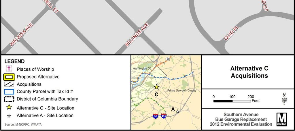
23 Figure 2-5: Alternative C Acquisitions November

24 Figure 2-6: Build Alternative C Proposed Concept Plan November
25 3.0 Affected Environment and Environmental Consequences This chapter identifies the existing conditions and the environmental consequences of the No Build Alternative and the proposed Build Alternatives. Potential mitigation strategies are provided for resources areas where impacts could occur. A list of all data sources used to conduct analysis and create figures in Chapter 3 can be found in Section 6.2 Data Resources. 3.1 Transportation Introduction This section identifies and assesses existing and future transportation conditions in the study areas and potential transportation impacts. Areas of roadway service and performance consist of network characteristics, including streets, intersection levels of service, signal system characteristics, and corridor travel times. The analysis addresses and evaluates the project s impact on the adjacent street network and recommends mitigation measures related to any negative impacts of site-generated traffic on the adjacent street network Methodology A detailed analysis was conducted to determine the potential effects on traffic for each alternative. Future build conditions were compared to the existing traffic conditions for identified intersections within the vicinity of each site. For Alternative A, a maximum capacity of 250 buses was assumed. For Alternative C, the minimum capacity of 150 buses was assumed. Study intersections evaluated include: No Build Alternative/Alternative C: o Southern Ave SE at Benning Road o Marlboro Pike at Benning Road o Marlboro Pike at Boones Hill Road o Southern Avenue at Marlboro Pike o Ridge Road at Bowen Road Alternative A: o Suitland Parkway WB at Forestville Road o Suitland Parkway EB at Forestville Road o Forestville Road at New Industrial Access Road o Forestville Road at Rena Road o Forestville Road at I-495 SB off ramp o Forestville Road at Allentown Road (including lefts to NB I-495 on-ramp) Existing conditions were established from turning movement counts at intersections identified above; 24- hour counts at the existing Southern Avenue Bus Garage; review of existing signal timing plans for identified signalized intersections, provided by the District of Columbia, State of Maryland, and Prince George s County; and bus turning movement data during peak periods 7:00am 9:00am and 4:00pm 6:00pm for the specified intersections above. To assess the future build condition (2015) for each alternative, a Synchro analysis was conducted. An annual growth rate was applied to the documented traffic volumes until 2015 and combined with the estimated trips to be generated by the build alternatives. For purposes of this analysis, each site is expected to generate 616 unique trips daily (combined buses and employees). Intersection performance was measured by level of service (LOS), which is a qualitative measurement of traffic determined by seconds of delay per vehicle at intersections. LOS is designated from A to F, with A representing the best traffic conditions and least delay and F representing the poorest conditions with the highest delay. For major urban area, LOS D or better is considered acceptable. For this analysis, impacts predicted to increase delay at intersections, resulting in a LOS D or worse, or to worsen delay at intersections currently operating at a LOS F, mitigation is proposed. Potential mitigation measures proposed are consistent with the guidance provided in the Maryland-National Capital Parks & Planning November
26 Commission, Prince George s County Planning Department Guidelines for the Analysis of Traffic Impact Development, September The analysis for Alternative A did not specifically include potential traffic generated from the larger AFC industrial site development. However, the analysis for Build Alternative A applied a conservative annual growth rate within the Synchro analysis to account for potential future growth No Build Alternative Existing Conditions As shown in Figure 3-1, the existing Southern Avenue Bus Garage is located at the intersection of Southern Avenue and Marlboro Pike. Southern Avenue is a four-lane arterial that follows the border between the District of Columbia and Prince George s County. Marlboro Pike is a four-lane arterial that connects the District of Columbia s southeast border to eastern Prince George s County, Maryland. A small access road, Pear Street, runs perpendicular to Southern Avenue and provides emergency access to the site. The eastern edge of the site is bordered by Boones Hill Road, which is a relatively short twolane local street between Southern Avenue and the entrance into the bus garage that crosses Marlboro Pike. Buses turn left at Marlboro Pike to turn left and right at Southern Avenue intersection. Employees and operators use the Boones Hill Road Entrance to access the facility. Key intersections serving the site and their existing LOS are included in Table 3-1 and identified in Figure 3-2. All of the intersections maintain an acceptable LOS. Environmental Consequences Future transportation conditions of the No Build Alternative were evaluated by taking into consideration the growth in background traffic. The MWCOG model indicates that there is no traffic growth on Southern Avenue in 2015, and a conservative 1 percent per year growth rate was used at all study intersections. This rate accounts for regional and development growth within the study area. Key intersections serving the site and their existing LOS are included in Table 3-1 and identified in Figure 3-2. All of the intersections experience a delay increase through 2015, but all maintain an acceptable LOS. The change in delay is attributed to growth and not to the existing bus garage. Table 3-1: No Build Alternative Intersection Conditions Intersection Conditions AM LOS (Delay*) PM LOS (Delay*) Intersection Name Traffic Control Existing Conditions No Build 2015 Existing Conditions No Build 2015 Benning Rd/ Southern Ave (North) Signalized C (21.4) C (22.4) B (18.9) C (20.1) Benning Rd/ Southern Ave (South) Signalized B (17.7) B (18.12) C (20.1) B (19.8) Benning Rd/ Marlboro Pike Signalized A (5.9) A (6.1) A (9.5) B (10.1) Boones Hill Rd/ Marlboro Pike Signalized A (3.5) A (3.5) A (4.6) A (4.7) Southern Ave/ Marlboro Pike Signalized D (40.3) D (44.5) D (37.6) D (41.4) Bowen Rd SE/ Ridge Rd Signalized D (44.9) D (50.9) C (26.4) C (27.7) *Delay measured in seconds. Potential Mitigation Since the increase in delay is attributed to incremental growth and not the existing bus garage, no direct adverse impact is expected; therefore, no mitigation is proposed. November
27 Figure 3-1: Transportation Network November


28 Figure 3-2: Traffic Study Intersections November
29 3.1.4 Alternative A Existing Conditions As shown in Figure 3-1, Alternative A is located southwest of the intersection of Suitland Parkway and the Capital Beltway (I-95/I-495). Alternative A is currently a cleared and graded site within a larger proposed industrial park without public access. The nearest intersection is Rena Road and Forestville Road. Access to the industrial park will be provided by a planned industrial access road directly off of Forestville Road, north of Rena Road. Forestville Road is a two-lane roadway that intersects with Suitland Parkway on the north and Allentown Road on the south. The closest signalized intersections are Forestville Road and Suitland Parkway to the northeast, and Forestville Road and Capital Beltway/Allentown Road to the east. At present, northbound (NB) Forestville Road between Allentown Road and the I-495 southbound (SB) off-ramp is closed. Since the publication of the June 2011 EA and this 2012 EE, the AFC industrial site has been approved by Prince George s County. It is assumed that the applied annual growth rate considered for the analysis will account for occupancy of the AFC industrial site. As part of the analysis, key intersections within close proximity to Build Alternative A were evaluated for the existing and build condition LOS. The key intersections are listed in Table 3-2 and shown in Figure 3-2. Table 3-2: Alternative A Intersection Conditions Intersection Conditions AM LOS (Delay*) PM LOS (Delay*) Intersection Name Traffic Control Existing Conditions No Build 2015 Build 2015 Mitigated Build 2015** Existing Conditions No Build 2015 Build 2015 Mitigated Build 2015** Allentown Rd/ Forestville Rd Signalized A (2.6) A (4.1) A (4.2) --- A (1.9) A (3.7) A (3.8) --- I-495 SB Off Stop F F F F Ramp/ F (142.9) C (29.7) F (211) Controlled (191.6) (295.2) (284.9) (333.9) Forestville Rd C (29.5) Rena Rd/ Stop C D D C (15.4) C (21.7) A (8.9) C (20.5) Forestville Rd Controlled (23.0) (31.8) (29.0) A (7.9) Suitland F F F Parkway EB/ Signalized E (58.3) F (174) --- F (106.8) (119.3) (132.3) (176.3) Forestville Rd --- Suitland F F F F Parkway WB/ Signalized F (150.0) --- F (141.9) (185.8) (189.1) (277.3) (264.9) Forestville Rd --- New Industrial Access Road/ C Signalized A (5.8) Forestville (20.8) Road Notes: *Delay measured in seconds. **No mitigation proposed because intersection are already operating below acceptable LOS in the existing and No Build 2015 condition Environmental Consequences Future transportation conditions of Build Alternative A were evaluated by taking into consideration the growth in background traffic. The MWCOG model indicates that there is no traffic growth on Forestville Road, Allentown Road, and Suitland Parkway in 2015, and a conservative 1 percent per year growth rate was used at all study intersections. This MWCOG model accounts for regional growth as well as the development growth within the study area. Data collected for the Andrews Federal Campus Traffic Impact Study (February 17, 2011) was used to project turning movement counts. To assess environmental consequences, the site was evaluated for a 2015 No Build scenario and a 2015 build scenario. As shown in Table 3-2, all intersections evaluated experience delay under the Build condition. However, for both the AM and PM peak, all intersections evaluated can be mitigated so that November
30 none of the intersections would operate below a LOS of D, which is considered acceptable by the Maryland State Highway Administration for two lane roadways. Alternative A will be accessed via a new industrial access road, constructed as part of a larger industrial development. The industrial access road will be two lanes and will provide a signal controlled intersection with Forestville Road. In addition, an emergency access road will be provided through the parcel adjacent and north of the planned site for the WMATA facility. Potential traffic generated from the larger industrial development was not included in the build analysis. Consideration for the proposed WMATA site-generated traffic would contribute cumulatively to traffic in the area is considered and presented in Section Key intersections serving the site and their existing LOS under the build scenario are included in Table 3-2 and identified in Figure 3-2. Permanent impact to traffic in the vicinity of the project site would be moderate. All of the intersections experience a delay increase in 2015 compared to existing traffic conditions. Potential Mitigation As project planning progresses, final mitigation for predicted traffic conditions would be coordinated with the appropriate state and local jurisdictions and all requirements for site development would be met. The following mitigation measures shown below are proposed to address predicted LOS delays shown in Table 3-2. I-495 SB Off Ramp/ Forestville Rd: Signalize the intersection Rena Rd/ Forestville Rd: Signalize the intersection The proposed mitigation above is consistent with that proposed in the Andrews Federal Campus Traffic Impact Study Report dated February 17, 2011.Alternative C Existing Conditions Same as the No Build Alternative. Environmental Consequences Future transportation conditions of Alternative C were evaluated by taking into consideration the growth in background traffic. The MWCOG model indicates that there is no traffic growth on Southern Avenue in 2015, and a conservative 1 percent per year growth rate was used at all study intersections. This rate accounts for regional growth as well as the development growth within the study area. To assess environmental consequences, the site was evaluated at a 2015 No Build scenario and a 2015 build scenario. Key intersections serving the site and their existing LOS under the No Build scenario are included in Table 3-3 and identified in Figure 3-2. All intersections experience a delay increase through Intersections that see a change in LOS are Benning Road at Southern Avenue (North) during the PM peak (from LOS B to C) and Benning Road at Marlboro Pike during the PM peak (from LOS A to B). Benning Road at Southern Avenue (South) shows an improved LOS during the PM peak (from LOS C to B). The rebuilt and expanded site will have separate access points for employees and buses. Employees and operators will access the site via a ramp entrance along Southern Avenue and buses will access the site at street level along Boones Hill Road. Buses will turn left at Marlboro Pike to turn left and right at Southern Avenue intersection. In addition, an emergency access drive is provided along Quinn Street. No impacts to Quinn Street have been identified. Key intersections serving the site and their existing LOS under the build scenario are included in Table 3-3 and identified in Figure 3-2. There would be no permanent impact to traffic in the vicinity of the project. All intersections have the same LOS or see an improvement. Potential Mitigation No mitigation is proposed, because no impact is anticipated. November
31 Table 3-3: Alternative C Intersection Conditions Intersection Conditions AM LOS (Delay*) PM LOS (Delay*) Intersection Name Benning Rd/ Southern Ave (North) Benning Rd/ Southern Ave (South) Benning Rd/ Marlboro Pike Boones Hill Rd/ Marlboro Pike Southern Ave/ Marlboro Pike Bowen Rd SE/Ridge Rd Southern Ave Entrance Boones Hill Rd Entrance Traffic Control Existing Conditions Signalized C (21.4) Signalized B (17.7) Signalized A (5.9) Signalized A (3.5) Signalized D (40.3) Signalized D (44.9) Stop Controlled Stop Controlled *Delay measured in seconds. No Build 2015 C (22.4) B (18.1) A (6.1) A (3.5) D (44.5) D (50.9) Does Not Exist Build 2015 C (22.4) B (18.7) A (6.1) A (3.6) C (30.8) C (30.6) C (17.6) A (8.9) Mitigated Build 2015 None Proposed None Proposed None Proposed None Proposed None Proposed None Proposed None Proposed None Proposed Existing Conditions B (18.9) C (20.1) A (9.5) A (4.6) D (37.6) C (26.4) No Build 2015 C (20.1) B (19.8) B (10.1) A (4.7) D (41.4) C (27.7) Does Not Exist Build 2015 B (17.7) B (16.6) B (10.2) A (4.7) C (31.5) C (31.3) C (17.9) A (9.8) Mitigated Build 2015 None Proposed None Proposed None Proposed None Proposed None Proposed None Proposed None Proposed None Proposed 3.2 Zoning Introduction This section documents the consistency of the proposed bus garage with the existing zoning for each location under review. This section also identifies any special exception permits, variances, or rezoning that would be required Methodology The alternatives were analyzed for consistency with existing local zoning regulations, as documented in the Prince George s County Zoning Ordinance No Build Alternative Existing Conditions The site is zoned Commercial Shopping Center (C-S-C), which allows for retail and service commercial activities generally located within shopping center facilities. Figure 3-3 shows existing zoning at the site. Environmental Consequences The current zoning is C-S-C, which is intended to provide for retail commercial shopping facilities and other compatible institutional, recreational, and service uses. However, the existing facility is grandfathered and allowable by right. No rezoning, variance, or special exception permit is required. November
32 3.2.4 Alternative A Existing Conditions The site is zoned Limited Intensity Industrial (I-4), which allows for limited intensity commercial, manufacturing, warehousing, and distribution uses. Prince George s County Zoning Ordinance indicates that the I-4 designation allows for a parking lot or garage, or loading area. In addition, this zoning designation requires a 25 percent green area per parcel. Figure 3-3 illustrates the designated zoning that applies to Alternative A. Environmental Consequences As proposed, Build Alternative A is consistent with the existing zoning. The provision of a bus garage and maintenance facility at this location is allowable under the current zoning, and no rezoning, variance, or special exception would be required. As proposed, the development of this parcel meets the 25 percent green area requirements Alternative C Existing Conditions As described for the No Build Alternative, the site is zoned Commercial Shopping Center (C-S-C), which allows for retail and service commercial activities generally located within shopping center facilities. The properties proposed for expansion are zoned as M-X-T, which allows for retail businesses; office/research/industrial; and dwellings/hotel/motel uses. Figure 3-3 shows existing zoning at the site. Environmental Consequences As proposed, Build Alternative C would expand the existing facility and require land use conversions of residential and commercial properties to an industrial use. Any expansion or rebuild would require a Special Exception, as these actions would be classified as intentional alterations of the existing grandfathered structure. The Special Exception process may take between 8 months to a year to be completed. November

33 Figure 3-3: Existing Zoning November
34 3.3 Land Acquisitions and Displacements Introduction This section identifies potential land acquisitions and displacements that would be needed for each alternative. Acquisitions would be differentiated based on the type of property being acquired. Any displacements that could result will be identified. Any land acquisition would be subject to the provisions of the Uniform Relocation Assistance and Real Property Acquisition Policies Act of 1970 as amended, which ensures that property owners, residents and businesses affected by the acquisition or demolition of real property during the construction of federallyfunded projects are treated fairly, consistently and equitably and that they do not suffer disproportionate injuries as a result of programs designed for the benefit of the public as a whole. Relocation assistance would follow the guidelines set forth in Title 49, Part 24 of the Code of Federal Regulations (49 CFR Part 24). Both federal and state laws require that property owners be paid fair market value for their land and improvements, and that property owners be assisted in finding replacement business sites or dwellings. If negotiations with any affected property owners are unsuccessful pursuant to the Uniform Relocation and Real Property Acquisition Policies Act, WMATA has the authority to acquire real property by condemnation as enumerated in Section 12. (d), Article V (General Powers) of the Washington Metropolitan Transit Authority Compact, P.L , 80 Stat (1966). As a multistate agency, WMATA s condemnations are handled by the U.S. Department of Justice. WMATA would only use its condemnation authority if it were unable to come to an agreement with an unwilling property owner Methodology Parcel information was obtained through Prince George s County GIS parcel data. Field visits and aerial photography were used to verify the condition and location of property and structures identified for acquisition No Build Alternative There would be no land acquisition or displacement associated with the No Build Alternative Alternative A Under Build Alternative A, WMATA would purchase the 35-acre parcel of land from the developer Jackson Shaw/Maryland and W.M. Schlosser. Purchase of this property would not result in any displacement Alternative C As proposed, Build Alternative C would extend beyond the existing 5.75-acre parcel currently owned by WMATA and therefore result in property acquisitions of parcels abutting the site. Some of the properties to be acquired would also result in displacements. The site would expand to approximately 7 acres. Table 3-4 summarizes the properties proposed for acquisition. Figure 2-8 in Chapter 2 shows the locations of these properties. Environmental Consequences All properties listed in Table 3-4 are located within the southwest corner of the block bounded by Southern Avenue, Quinn Street, Marlboro Pike, and Boones Hill Road and would be acquired to accommodate the proposed expansion. In all, seven parcels and one road, totaling approximately 1.3 acres, would be affected and result in the displacement of five businesses, the occupants of one residence, and one church. Figure 2-8 in Chapter 2 shows the locations of these parcels. Each land acquisition would be conducted in accordance with the Uniform Relocation Assistance and Real Property Acquisition Policies Act as discussed in Section Relocation assistance would follow the guidelines set forth in Title 49, Part 24 of the Code of Federal Regulations (49 CFR Part 24). Relocation resources would be made available to all displaced residents, businesses and nonprofit November
35 organizations without discrimination. WMATA would prepare a detailed acquisition and relocation plan before initiating any land acquisition or relocation activity. Table 3-4: Proposed Property Acquisitions Build Alternative C County Parcel Tax Property ID Size (Acres) Address Use Establishment Owner Status Teachings from 4270 Pear Place of the Holy Ghost BWF Southern Street Worship Under God LLC Occupied Church of Christ 4208 Quinn Street 4401 Southern Avenue 4403 Southern Avenue 4405 Southern Avenue 4415 Southern Avenue Residential Commercial Commercial Commercial Commercial Not applicable White Corner Restaurant Not applicable (Not in use) SAG Graphics & Printing 4411 Southern Plaza: Work Dat Cell Phones (4415) Maiatico, Teresa & Mary R Jeon, Kyong C Redshift LLC Occupied Occupied Occupied Sharrofna, Aref A Occupied BWF Southern LLC Occupied Southern Avenue Commercial N/A 0.21 Pear Street Road Total Acreage Salon Monica (4413) CLG Education Consultant (4409) The Hobo Shop (4407) Not applicable. Currently used as the Southern Avenue Bus Garage Emergency Exit BWF Southern LLC Public Access Road Occupied N/A 3.4 Neighborhoods and Community Resources Introduction This section identifies direct impacts on neighborhoods and community resources Methodology A qualitative assessment of potential risk on children resulting from the proposed action was completed for this study. Each site was evaluated to determine if there were community facilities that cater to children adjacent to or within close proximity of the site. In order to assess impacts on neighborhoods and community resources, a qualitative evaluation was done to determine if the proposed action would: create a physical barrier within a neighborhood; isolate a portion of a neighborhood; or have a direct impact on a community facility or access to a community facility. For purposes of this analysis, parks are described in Section 3.8. November
36 3.4.3 No Build Alternative Existing Conditions The following neighborhoods and community facilities were identified within proximity to the No Build Alternative/existing facility: Neighborhoods: Prince George s County neighborhoods within close proximity of the existing bus garage are Capitol Heights to the northeast and Boulevard Heights and Bradbury Heights to the south. District of Columbia neighborhoods within close proximity of the existing bus garage include Fort Davis and Benning Ridge. The neighborhoods and community resources for the No Build Alternative are described below and identified in Figure 3-4. o Capitol Heights: Capitol Heights is located directly northeast of the No Build Alternative site and generally bounded by Marlboro Pike, Southern Avenue, Capitol Heights Boulevard, Tunic Avenue, and Central Avenue. Capitol Heights was developed throughout the 20th century and includes single-family homes, community facilities, and some commercial uses. o Boulevard Heights and Bradbury Heights: Boulevard Heights and Bradbury Heights are located directly south of the No Build Alternative and generally bounded by Quinn Street, Southern Avenue, John Eager Howard Elementary School, and Pennsylvania Avenue. The neighborhood was established in the early 20th century and developed through the 1970s. The neighborhood includes single-family, detached residential homes with varying setbacks laid on a street grid. Limited commercial development is also located along Southern Avenue. o Fort Davis: Fort Davis is in Southeast Washington, DC, located directly west of the No Build Alternative and generally bounded by Southern Avenue; Pennsylvania Avenue, SE; Alabama Avenue, SE; and Bowen Road, SE. The neighborhood includes single-family residential homes with varying setbacks. Limited commercial development is also located along Southern Avenue. o Benning Ridge: Benning Ridge is in Southeast Washington, DC, located directly west of the No Build Alternative and generally bounded by Southern Avenue, Benning Road, SE; Texas Avenue, SE; and Ridge Road, SE. The neighborhood includes single-family detached residential homes, attached townhomes, and multi-story public housing developments. Limited commercial development is also located along Benning Road, SE and Southern Avenue. Community Resources: Several places of worship, a preschool, and a senior center exist within close proximity to the existing bus garage and are detailed in Table 3-5 and Figure 3-4 shows the locations. November

37 Figure 3-4: Neighborhoods and Community Facilities November
38 Table 3-5: Community Resources near the No Build and Build Alternatives Site Community Facility Type Address Ownership Free Gospel Deliverance 4703 Marlboro Pike Capitol Place of Worship Temple Heights MD Private God of a Second Chance 4411 Bowen Road SE Place of Worship Ministry Washington DC Private 4407 Bowen Road SE No Build New Strait Gate Baptist Church Place of Worship Private Washington DC Alternative/ 4339 Bowen Rd SE Alternative C Randall Hyland Private School School Private Washington DC Robert L. Walls Senior Citizens Senior Citizen 4339 Bowen Road SE Center Center Washington DC Private Teachings from the Holy Ghost, 4270 Pear Street Place of Worship Under God Church of Christ Capitol Heights MD Private Benjamin D. Foulois Creative 4601 Beauford Road School and Performing Arts Academy Suitland MD Public Alternative A Imagine Foundation 6900 Ames Street Suitland School Morningside MD Public Morningside Matthew P. Rosch 6901 Ames Street Municipal Center Municipal Center Suitland MD Public The Ephesians New Testament 4301 Forestville Road Place of Worship Church of God In Christ District Heights MD Private Environmental Consequences Existing conditions would continue under the No Build Alternative. The No Build Alternative would not isolate any neighborhood or impact any community resource. No potential health or safety risk to children was identified for this site. Potential Mitigation Since existing conditions would remain unchanged, no adverse impact would occur; therefore, no mitigation is proposed Alternative A Existing Conditions The following neighborhoods and community facilities were identified within proximity to Build Alternative A: Neighborhoods: The neighborhoods in the vicinity of Alternative A are Morningside and Forest Village. These two neighborhoods are described below and identified in Figure 3-4. o Morningside: Morningside is adjacent to Alternative A, bounded by the western boundary of Alternative A, Suitland Road, Suitland Parkway, and the Capital Beltway. Morningside was developed in the 1940s and includes single-family homes, community facilities, and limited commercial development along Suitland Road. The neighborhood is laid out with curvilinear streets and contains large lots with uniform setbacks. o Forest Village: Forest Village is adjacent to Alternative A, bounded by Rena Road, Forestville Road, and the Capital Beltway. The community was developed in the 1960s and includes three-story, multi-family dwelling buildings and private facilities. Access to the neighborhood is through Rena Road. Community Resources: Four active community resources exist in the site area. These resources are detailed in Table 3-5 and include a place of worship, a public charter school, a public magnet school, and a town-owned municipal center that house community and police facilities. Figure 3-4 shows the location of these resources. November
39 Environmental Consequences Implementation of Alternative A would not result in creating barriers that would divide or isolate portions of identified neighborhoods. Furthermore, no direct impact or elimination of access to any identified community resources would occur. Benjamin D. Foulois Creative and Performing Arts Academy and the Imagine Foundation Morningside are adjacent to and west of Alternative A. These facilities serve a range of school-aged children. No specific health or safety risk to children was identified for Alternative A to the children that use this school. The site would provide for appropriate safety and security measures to prohibit trespassing and appropriate barriers between bus facility activities and adjacent property. Under the previous evaluation in June 2011, Alternative A proposed the primary access via an extension of Rena Road and an emergency access road via an extension of Ames Street. The current proposed Alternative A has eliminated both the use of Rena Road as the primary access road to the site and the extension of Ames Street for emergency access. Buses and other garage-related traffic would avoid the use of residential streets when accessing the facility Potential Mitigation Alternative A would not isolate any neighborhood or impact any community resource; therefore, no mitigation is proposed Alternative C Existing Conditions Neighborhoods and community facilities within proximity to Build Alternative C are discussed in Section Environmental Consequences Implementation of Alternative C would not result in creating barriers that would divide or isolate portions of identified neighborhoods. There would be acquisitions and displacements associated with Alternative C to include commercial, residential and a place of worship properties (see Section 3.3). No increased potential health or safety risk to children was identified for this location. Potential Mitigation Mitigation for the acquisitions and displacements are documented in Section Environmental Justice Introduction This section addresses the potential for disproportionate and adverse effects on minority and low-income populations Methodology This section describes the methodology for identify existing minority and low-income populations within the analysis areas. The analysis was prepared in general accordance with FTA Circular Environmental Justice Policy Guidance For Federal Transit Administration Recipients (August 15, 2012). Census tract, block group, and block data were used to identify minority and low-income populations within the study areas as well as larger geographic areas used for comparison. For the purposes of this analysis, study area for demographics was assessed at a ¼-mile distance from each site boundary. Minority Populations A minority is defined as: Individual(s) who are members of the following population groups: American Indian or Alaskan Native; Asian or Pacific Islander; Black, not of Hispanic origin; or Hispanic. The Council on Environmental Quality (CEQ) Environmental Justice, Guidance Under the National Environmental Policy Act was used define geographic concentrations of minority November
40 populations within the study area. The CEQ guidance identifies minority populations where either: The minority population of the affected census block exceeds 50 percent; or The minority population percentage of the affected census block is meaningfully greater (10 percent) than the minority or low-income population percentage in the general population and larger geographic comparison areas (in this case the WMATA Compact Area and Prince George s County/Southeastern Washington, D.C.). In addition to the study areas defined, two additional geographic areas are provided for comparison: Prince George s County/Southeastern Washington, D.C. (comprising the area of the District of Columbia south of East Capitol Street and east of the Anacostia River and all of Prince George s County) and the WMATA Compact area (comprising Prince George s County, Maryland; Montgomery County, Maryland; District of Columbia; Arlington County, Virginia; City of Alexandria, Virginia; City of Fairfax, Virginia; Fairfax County, Virginia; and City of Falls Church, Virginia). Table 3-6 provides the demographic characteristics of the comparison areas. Figure 3-5 illustrates the boundaries of the geographic comparison areas. Table 3-6: Minority Populations Comparison Area Total Population Minority Population Percent of Total Population WMATA Compact Area 3,901,136 2,262,651 58% Prince George's County/Southeastern Washington, DC 982, ,914 87% Source: U.S. Census Bureau, 2010 Decennial Census, Summary File 1. Low-Income Populations FTA Circular defines low-income as a person whose median household income falls below U.S. Department of Health and Human Services (HHS) defined poverty guidelines or as a percentage of median income for the local area if that threshold is at least as inclusive as the HHS poverty guidelines. The HHS poverty guidelines are national averages produced for the 48 contiguous states and the District of Columbia, and as such do not reflect the local cost of living. The analysis therefore uses U.S. Department of Housing and Urban Development (HUD) FY2010 median income and poverty guideline limits to define low income households using Washington-Arlington- Alexandria, DC-VA-MD HUD Metro Fair Market Rent (FMR) Area data. As described by HUD, Fair Market Rents (FMRs) are primarily used to determine payment standard amounts for HUD s Housing Choice Voucher program for low-income and very low-income families throughout the United States. FMR income categories more accurately reflect local cost of living conditions and are used as a basis to qualify households for housing assistance. HUD uses income limits that define Low Income as those households earning less than 80 percent of Area Median Income (AMI), with households making less than 50 percent of AMI defined as Very Low Income, and those making 30 percent of AMI or less as Extremely Low Income. Fiscal Year 2010 AMI for families in the Washington DC FMR Area was $103,500. Like the Department of Health and Human Services (HHS) poverty guidelines, HUD s FMR income limits are defined by household size. The FY2010 AMI income limits for a Low Income family of four of $64,400 was used as the AMI definition for low income in this analysis. Income data is only available at the Census tract level. November


41 Figure 3-5: Environmental Justice Comparison Areas November
42 The Washington-Arlington-Alexandria, DC-VA-MD HUD Metro FMR Area is larger than the WMATA Compact Area and includes the following jurisdictions: District of Columbia, DC ; Calvert County, MD; Charles County, MD; Frederick County, MD ; Montgomery County, MD ; Prince George s County, MD ; Arlington County, VA ; Clarke County, VA; Fairfax County, VA ; Fauquier County, VA; Loudoun County, VA ; Prince William County, VA ; Spotsylvania County, VA; Stafford County, VA ; Alexandria city, VA; Fairfax city, VA ; Falls Church city, VA ; Fredericksburg city, VA ; Manassas city, VA ; and Manassas Park city, VA. Census tracts within a ¼-mile distance from each site boundary were analyzed to determine if the AMI for each tract was below the $64,400 threshold. Census tracts below the income threshold are considered low income populations, that is at least 50 percent of 4-person households within the census tract earned less than $64,400 in Effects Assessment The CEQ guidance defines disproportionately high and adverse environmental effects on environmental justice populations. The guidance recommends consideration of the significance and severity of the impact on a minority, low-income, or Indian tribe; or if the identified effects could contribute cumulatively to result in significant or adverse effects on a minority, low-income, or Indian tribe. The analysis presented below looks at the potential for disproportionate adverse effects at each site and also provides a comparison of each alternative to evaluate if one alternative has a greater potential to experience disproportionately high and adverse effects over another. This section only addresses those resource areas where impacts have been identified. These resources comprise traffic, land acquisitions and displacements, and noise. No other resources are expected to be adversely affected No Build Alternative The existing Southern Avenue Bus Garage is located within a minority population that meets the environmental threshold of having a population of 50 percent or greater of minority persons within the defined study area. Low-income populations also exist within the study area. As shown in Table 3-7, the majority of the population of the comparison study area for Prince George s County/Southeastern Washington, D.C. is minority. Table 3-7 provides the demographic characteristics of the populations within the study area for the existing facility. Table 3-7: No Build Study Area Comparison of Environmental Justice Population Characteristics Prince George s County/Southeastern DC WMATA Compact Area Existing Facility Study Area Total Population 982,779 3,901,136 2,367 % Minority Population 87% 58% 98% Source: U.S. Census Bureau, 2010 Decennial Census, Summary File 1. Environmental Consequences No project-related impacts on potential environmental justice communities have been identified for the No Build Alternative. Operation of the Southern Avenue Bus Garage would remain the same. Under the No Build Alternative, no adverse effect on traffic has been identified; however, land acquisitions and displacements may occur within the study area that would be unrelated to the operation of the existing Southern Avenue Bus Garage that could affect the minority and low-income populations within the study area. Local planning documents, such as the Marlboro Pike Master Plan and Endorsed Sectional Map Amendment, have envisioned transforming this area in ways that may result in private development acquiring and subsequently displacing persons or businesses. Existing ambient noise conditions would remain the same. Potential Mitigation Because no project-related effects have been identified, no mitigation is proposed. However, effects on potential environmental justice populations may occur under the No Build Alternative. Any adverse effect November
43 on environmental justice communities occurring under other actions that may occur under the No Build would be the responsibility of the public agency implementing an action and required to comply with Executive Order Build Alternative A Existing Conditions The site for Build Alternative A is located within an area with a minority population that meets the threshold of having a population of 50 percent or greater of minority persons within the defined study area. Low-income populations also exist within the study area. As shown in Table 3-8, the majority of the population of the comparison study area for Prince George s County/Southeast, District of Columbia is minority. Table 3-8 provides the demographic characteristics of the populations within the study area for Build Alternative A. Table 3-8: Alternative A Study Area Comparison of Environmental Justice Population Characteristics Prince George s County/Southeastern DC WMATA Compact Area Total Population 982,779 3,901,136 1,038 Alternative A Study Area % Minority Population 87% 58% 87% Source: U.S. Census Bureau, 2010 Decennial Census, Summary File 1 Environmental Consequences The location for Build Alternative A is within close proximity to the existing Southern Avenue Bus Garage and would continue to provide service to the same service area as the existing facility. Potential effects on traffic have been identified with this alternative; however, mitigation is proposed to offset the potential adverse effects, as described in Section 3.1 of this EA. The land acquisition associated with this site would not displace any minority populations or minority-owned businesses. No exceedance of the FTA noise thresholds has been identified as a result of implementation of a bus garage at this location. As proposed, the WMATA facility at this location would be part of a new, larger industrial park. Due to this proposed arrangement, the Forest Village complex may also experience effects from this larger development due to increased traffic, noise, changes to the visual environmental, and removal of trees and landscaping. Because the WMATA facility would be part of this larger industrial park, the bus garage would contribute to the overall effects on this community. Potential Mitigation As described in Section 3.1 Transportation Effects, mitigation is proposed to improve impacted intersections. While no adverse visual or noise effects were identified, the site provides a tree buffer to lessen visual and noise effects. No other adverse effect on the identified minority and low-income populations has been identified; therefore, no other mitigation is proposed Build Alternative C Existing Conditions The site for Build Alternative C is located within a minority population that meets the environmental threshold of having a population of 50 percent or greater of minority persons within the defined study area. Low-income populations also exist within the study area. As shown in Table 3-9, the majority of the population of the comparison study area for Prince George s County/Southeast, District of Columbia is minority. Table 3-9 provides the demographic characteristics of the populations within the study area for Build Alternative C. November
44 Table 3-9: Alternative C Study Area - Comparison of Environmental Justice Population Characteristics Prince George s County/Southeastern DC WMATA Compact Area Alternative C Study Area Population 982,779 3,901,136 2,367 % Minority Population 87% 58% 98% Source: U.S. Census Bureau, 2010 Decennial Census, Summary File 1 Environmental Consequences The location for Build Alternative C is at the same location as the existing facility and would continue to provide service to the same service area as the existing facility. The expansion of the existing facility at this location would result in land acquisitions and subsequent displacements. One community facility would be impacted by these acquisitions; a full acquisition and displacement of the Teachings from the Holy Ghost Under God Church of Christ community facility would also occur as part of the site expansion as described in Section 3.3. Additionally, Build Alternative C would result in a noise impact under the FTA criteria, as described in Section Potential Mitigation Potential mitigation is proposed in Section 3.10 for the noise impact. All land acquisitions and displacements would be done in accordance with the Uniform Relocation Assistance and Real Property Acquisition Policies Act of 1970 as amended, and Title 49, Part 24 of the Code of Federal Regulations (49 CFR Part 24) Comparison of Disproportionately High Adverse Effects of Build Alternatives WMATA bus garage and maintenance facility locations are evenly dispersed throughout the WMATA service area and region, as shown in Figure 3-6. WMATA selects locations for its facilities based on service needs and available property that can be developed to meet WMATA program requirements. Typically, bus garages are located within close proximity of the areas that the buses serve to reduce deadhead times. ( Deadhead is a transit term which means the miles and hours that a vehicle travels when out of revenue service (not serving passengers). Build Alternative A and C are both located in the same service area as the existing Southern Avenue Bus Garage. Build Alternative C would result in the most direct adverse impacts on identified minority and low-income populations that in comparison with the other proposed alternatives may be considered disproportionate. While Build Alternative A in and of itself would not result in quantifiable direct adverse impacts to minority or low-income populations, when combined with the potential effects of the planned larger industrial park, the alternative may result in disproportionate adverse effects to the adjacent populations. For both build alternatives, potential impacts identified to each of the surrounding potential environmental justice communities would be mitigated proportionate to the effects identified. WMATA would ensure that for either build alternative that mitigation treatments are consistent with any mitigation that might be proposed or planned for other WMATA facilities in non-environmental justice communities. November


45 Figure 3-6: Environmental Justice November
46 3.6 Consistency with Local Plans Introduction This section identifies and assesses the consistency of the proposal with adopted transportation and land use plans that apply to each alternative Applicable Adopted Local Planning Documents This section reviews the goals and policies within the plans of local jurisdictions and other agencies to assess the consistency of the. These plans include countywide land use, transportation, and environmental plans adopted by Prince George s County, and transportation plans adopted by WMATA. Specific plans and planning efforts reviewed for project consistency include: Prince George s County Approved General Plan (October 2002) Prince George s Countywide Green Infrastructure Plan (June 2005) Marlboro Pike Master Plan and Endorsed Sectional Map Amendment (2009) Preliminary Subregion 4 Master Plan and Proposed Sectional Map Amendment (2009) Preliminary Subregion 6 Master Plan and Proposed Sectional Map Amendment (2009) Countywide Master Plan of Transportation (November 2009) 2010 Metrobus Fleet Management Plan (2010) Prince George s County Approved General Plan (October 2002) The Prince George s County Approved General Plan sets a comprehensive policy framework for Prince George s County. The General Plan identifies three areas of growth within the county: the developed tier; the developing tier; and the rural tier. The county s vision for the developed tier is a network of sustainable, transit-supporting, mixed-use, pedestrian-oriented, medium- to high-density neighborhoods. One of the primary ways to achieve this goal is to capitalize on investments in transportation. The county s vision for the developing tier is to maintain a pattern of low- to moderate-density suburban residential communities, distinct commercial centers, and employment areas that are increasingly transit serviceable. Prince George s County envisions compact, higher-intensity, mixed-uses in the distinct commercial centers and corridors. The policy goals for each tier are meant to inform planning done at the subregion and sector levels. The plan is applicable to all alternatives evaluated in this document. Prince George s Countywide Green Infrastructure Plan (June 2005) As the first functional master plan of its kind in Prince George s County, the Countywide Green Infrastructure Plan seeks to support the policies of the General Plan and identifies existing green infrastructure elements throughout the county. Green infrastructure is defined as an interconnected network of waterways, wetlands, woodlands, wildlife habitats, and other natural areas of countywide significance. The plan identifies a contiguous network of environmentally sensitive areas throughout the county and sets forth a goal, objectives, policies, and strategies to preserve, protect, and enhance these elements by the year The plan is applicable to Alternative A evaluated in this Environmental Assessment, but is not applicable to the No Build Alternative or Alternative C since no identified green infrastructure features exist on these sites. Marlboro Pike Master Plan and Endorsed Sectional Map Amendment (2009) While the General Plan sets a comprehensive policy framework for Prince George s County, detailed planning is done at the subregion and sector plan levels. The Marlboro Pike Master Plan and Endorsed Sectional Map Amendment provides the guiding policy for the Marlboro Pike Corridor. The plan seeks to address the area s deteriorating condition by developing policies to guide investment, revitalization efforts, and development along the Marlboro pike corridor. The plan recommends enhancing the node at Marlboro Pike and Southern Avenue to incorporate commercial/mixed use development and revitalize this gateway from the District of Columbia into Prince George s County. The plan is applicable to all alternatives evaluated in this document. November
47 Preliminary Subregion 4 Master Plan and Proposed Sectional Map Amendment (2009) Subregion 4 is located in central Prince George s County and borders the District of Columbia. The Preliminary Subregion 4 Master Plan and Proposed Sectional Map Amendment contains recommendations for land use; environment; transportation systems, including roadways, transit, bicycle, pedestrian, and trail facilities; public facilities; parks and recreation; historic preservation; and urban design. The plan seeks to implement the policy goals of the General Plan to improve quality of life, promote mixed-use development along transportation corridors and at targeted centers and nodes, encourage local economic development, and protect environmentally sensitive areas. Since Marlboro Pike lies within Subregion 4, the plan builds upon the recommendations of the 2009 Marlboro Pike Preliminary Corridor Sector Plan and Proposed Sectional Map Amendment. The plan is applicable to the No Build Alternative and Alternative C evaluated in this document. Preliminary Subregion 6 Master Plan and Proposed Sectional Map Amendment (2009) The Preliminary Subregion 6 Master Plan and Proposed Sectional Map Amendment applies to the subregion in the southeast portion of Prince George s County. Because the Westphalia Preliminary Sector Plan and Proposed Sectional Map Amendment provides the guiding policy for the area, this plan does not address any areas applicable to the alternatives evaluated in this document. Countywide Master Plan of Transportation (November 2009) The Countywide Master Plan of Transportation (MPOT) for Prince George s County is the functional master plan that addresses the strategic transportation issues for all modes in Prince George s County. The MPOT was written to guide public and private resources to transportation policies, programs, facilities, and services that will help attain the goals and concepts in the General Plan. Two of the primary goals, as identified in the MPOT, are to improve the transportation network to reduce congestion and vehicle miles traveled, and to provide strategic transportation and transit guidance. One of the specific goals of the plan is to provide adequate transportation facilities. The plan is applicable to all alternatives evaluated in this document Metrobus Fleet Management Plan (2010) The Metrobus Fleet Management Plan provides a system-wide analysis for fleet growth through FY2020, taking into consideration current and future ridership demand, proposed service enhancements, supply of new buses, and capacities of the Metrobus maintenance programs and facilities. As part of the plan s evaluation of WMATA s system-wide garage capacities, the existing Southern Avenue Bus Garage is identified as an older garage over its capacity of 103 Metrobus vehicles. The Metrobus Fleet Management Plan calls for the replacement of the Southern Avenue Bus Garage. See 1.0 Purpose and Need for the Project. The plan is applicable to all alternatives evaluated in this document No Build Alternative The No Build Alternative is not consistent with any of the applicable plans detailed in Section The alternative is not consistent with WMATA s Metrobus Fleet Management Plan as the plan calls for the replacement of the existing Southern Avenue Bus Garage. The No Build Alternative is not consistent with the Prince George s County Approved General Plan since it is inconsistent with the goals set forth for the developed tier. The site is inconsistent with policies on providing a transportation system that is integrated and that promotes development and revitalization, nor on providing public facilities to support and fit into the developed tier s development pattern. The alternative is not consistent with the Countywide Master Plan of Transportation because it does not provide adequate transportation facilities. The No Build Alternative is also not consistent with the Marlboro Pike Master Plan and Endorsed Sectional Map Amendment and the Preliminary Subregion 4 Master Plan and Proposed Sectional Map Amendment. Both of the plans call for the existing site to become a commercial/mixed use development Alternative A Development of Alternative A would not require any amendments to any adopted local applicable plan detailed in Section Alternative A is consistent with WMATA s Metrobus Fleet Management Plan, which calls for the replacement of the existing Southern Avenue Bus Garage. The site is within the November
48 developed tier described in Prince George s County Approved General Plan and is consistent with policies on providing a transportation system that is integrated and promotes development and revitalization, and on providing public facilities to support and fit into the developed tier s development pattern. The alternative is consistent with the Countywide Master Plan of Transportation by providing adequate transportation facilities. Alternative A is inconsistent with the Prince George s Countywide Green Infrastructure Plan since identified evaluation areas and network gaps exist within the site. However, development of this site is allowable under current and future zoning Alternative C Development of Alternative C would not require any amendments to the identified adopted local plans detailed in Section The alternative is consistent with WMATA s Metrobus Fleet Management Plan as the plan calls for the replacement of the existing Southern Avenue Bus Garage. Alternative C is somewhat consistent with the vision laid out in Prince George s County Approved General Plan because the new structure could promote development and revitalization However, the revised proposal for Alternative C does not include a retail component, whereas the previous proposal in 2011 did. The alternative is consistent with the Countywide Master Plan of Transportation policy for providing adequate transit facilities to County residents. Build Alternative C is not consistent with the Marlboro Pike Master Plan and Endorsed Sectional Map Amendment and the Preliminary Subregion 4 Master Plan and Proposed Sectional Map Amendment. Both of the plans call for the existing site to become a commercial/mixed-use development. Table 3-10 below provides an overview of local plan consistency across all alternatives. Table 3-10: Consistency with Local Plans No Build Alternative Alternative A Alternative C Prince George s County Approved General Plan Inconsistent Consistent Inconsistent Prince George s Countywide Green Infrastructure Plan Marlboro Pike Master Plan and Endorsed Sectional Map Amendment Not applicable Inconsistent Not applicable Inconsistent Not applicable Inconsistent Preliminary Subregion 4 Master Plan and Proposed Sectional Map Amendment Inconsistent Not applicable Inconsistent Countywide Master Plan of Transportation Inconsistent Consistent Consistent 2010 Metrobus Fleet Management Plan Inconsistent Consistent Consistent 3.7 Cultural Resources Introduction This section identifies and evaluates the potential to impact cultural resources resulting from the project Methodology Cultural resources include historic and prehistoric archaeological sites as well as historic districts, structures and objects listed in or potentially eligible for inclusion in the National Register of Historic Places (NRHP) and/or the State of Maryland Register of Historic Places (MRHP). Qualified archaeologists and architectural historians conducted research at the Maryland Historical Trust (MHT) and site visits to identify historic architectural and archaeological resources within or in proximity to the three alternative site locations. The Section 106 process was initiated with the Maryland Historical Trust on April 14, Section 106 correspondence regarding concurrence can be found in Appendix A Agency Correspondence. For each site, an Area of Potential Effect (APE) was defined for both architectural and archaeological resources. For architectural resources, the APE included the site and some adjacent properties. For archaeological resources the APE included the site boundaries. November
49 3.7.3 No Build Alternative Existing Conditions Historic Architectural Resources: No eligible historic architectural resource exists at the site based on research and determinations made by the Maryland Historical Trust. 1 This finding can be found in Appendix A Agency Correspondence. Archaeological Resources: No previously identified archaeological site (prehistoric or historic) exists within the site. A low potential for prehistoric archaeological resources exists that does not warrant a field investigation based on an evaluation of topographic mapping and geotechnical borings. Environmental Consequences The No Build Alternative would not alter the existing facility. In addition, no cultural resource was identified on or adjacent to the site. Therefore no impact to any cultural resource would occur as a result of the No Build Alternative. Potential Mitigation No impact is expected, therefore no mitigation is proposed Alternative A Existing Conditions Historic Architectural Resources: A review of files held by MHT found no National Registerlisted or -eligible resources within the project boundaries of Alternative A. However; one National Register-eligible resource, the Morningside Historic District, is located adjacent to and west of the project boundaries. The Morningside Historic District was determined eligible for listing in the National Register on September 14, Figure 3-7 identifies the APE for architectural resources and adjacent cultural resources. Archaeological Resources: A review of historic aerials and USGS maps indicate no structure was located within the site, hence, the potential for historic archaeological resources is considered low. Research conducted at MHT did not reveal any previously documented archaeological resources. During the June 2011 EA, the site was documented as having a potential for prehistoric archaeological resources and MHT requested that a Phase I Archaeological evaluation be conducted. As such, the requested documentation was prepared and presented to MHT for review and consideration. However, since that time, the site has been cleared, grubbed and graded. Figure 3-7 identifies the APE for archaeological resources and adjacent cultural resources. Environmental Consequences A letter was received from MHT, dated July 6, 2011, stating that Based on the results of the current investigations, as well as the findings from our previous reviews in June 2009 and April 2011, the proposed alternatives will have no effect on historic properties, including archeological resources. In addition, the MHT requested WMATA to provide additional information to conclude the consultation process. In September 2012, WMATA provided the requested information. See Appendix A Agency Correspondence for correspondence with MHT. Potential Mitigation No impact to cultural resources was identified therefore no mitigation is proposed. 1 Washington Metropolitan Area Transit Authority previously conducted a study and initiated correspondence with the MHT regarding the replacement of the Southern Avenue Bus Garage in May November


50 Figure 3-7: Build Alternative A Cultural Resources November
51 3.7.5 Alternative C Existing Conditions Existing conditions for Build Alternative C are the same as described under the No Build Alternative. Environmental Consequences A letter was received from MHT, dated July 6, 2011, stating that Based on the results of the current investigations, as well as the findings from our previous reviews in June 2009 and April 2011, the proposed alternatives will have no effect on historic properties, including archeological resources. In addition, the MHT requested WMATA to provide additional information to conclude the consultation process. In September 2012, WMATA provided the requested information. See Appendix A Agency Correspondence for correspondence with MHT. See Appendix A Agency Correspondence for correspondence with MHT. Potential Mitigation No impact to cultural resources would occur therefore no mitigation is proposed. 3.8 Parklands Introduction This section identifies and assesses the potential impact to public parklands, recreational areas, and wildlife refuges. Public parklands could include local, state, and federally-owned parklands Methodology Public parklands adjacent to or within close proximity to the alternative site locations were identified with a variety of data sources. The analysis consisted of gathering existing information through site visits, recent aerial photographs, and information provided by Prince George s County. A review of parks protected by Section 6(f) of the U.S. Land and Water Conservation Fund Act (LWCF) was conducted to determine if any identified parks within the study areas were enhanced using these funds. Potential uses of publicly-owned park and recreational resources caused by the project are described in terms of acreage and how activities and facilities at these areas could be impacted. Table 3-11 summarizes the resources identified. Table 3-11: Identified Parklands Alternative Site Park Location Size Alternative A Alternative C Douglas Patterson Community Park No public parklands identified 7001 Marianne Dr. Morningside, MD Not applicable Ownership/ Operated By 26.4 Acres M-NCPPC Not applicable Not applicable Source: M-NCPPC Park Finder, No Build Alternative Existing Conditions No parkland exists adjacent to or within immediate proximity to the site. Amenities -Basketball Court -Comfort Station -2 Tennis Courts -3 Picnic Areas -Playground -2 Softball w/football and Soccer Overlay Fields -Trails Not applicable November
52 Environmental Consequences The No Build Alternative will not require the use of or have an indirect impact on parklands. Potential Mitigation No impact is projected; therefore, no mitigation is proposed Alternative A Existing Conditions Douglas Patterson Community Park borders the south side of the site. See Table 3-11 for information about Douglas Patterson Community Park and Figure 3-8 for the location of the park. A review of the LWCF list of grant recipients indicates that this park is not a recipient of LWCF funds and, therefore, is not protected under the provisions of Section 6(f). Environmental Consequences As proposed, Build Alternative A would not require the use or acquisition of any portion of the park. The bus garage would not impact or restrict access or disrupt any current function of the park. As shown in Figure 3-8, Douglas Patterson park is bordered by I-495/I-95 on its south side. The portion of the park between the proposed bus garage site and the interstate does not have designated recreational use and appears to serve as green space. Additionally, an unmarked footpath exists in this area between the Forest Village apartments and the Benjamin D. Foulis school and Douglas Patterson Park. However, as proposed, the bus garage would be entirely within the developer-owned property and not within the property boundaries of the park. The proposed bus garage would be separated from the park property by a tree buffer and security fencing. Additionally, based on the noise impact assessment discussed in greater detail in Section 3.11, the proposed facility would not exceed the threshold for severe impacts at this sensitive receptor and, therefore, no proximity effects related to noise will occur. Alternative A would not generate any adverse impacts on the park resource. Potential Mitigation No impact is projected; therefore, no mitigation is proposed Alternative C As described for the No Build Alternative, no public park is located adjacent to or within close proximity of the site; therefore, no use of or acquisition of a public park will occur. November

53 Figure 3-8: Public Parklands November
54 3.9 Air Quality Introduction This section identifies and assesses the potential effects on regional air quality in accordance with the Clean Air Act, as amended. The project is listed in the Transportation Improvement Program for the Metropolitan Washington region for fiscal years (TIP ID number 5857). The TIP is provided in Appendix B Methodology Under the Clean Air Act, it is the responsibility of federal agencies such as the FTA to ensure that a proposed project conforms to the State Implementation Plan (SIP). Transportation conformity is a process required of the Metropolitan Washington Council of Governments (MWCOG) as the region s metropolitan planning organization pursuant to the Clean Air Act Amendments (CAAA), to ensure that those transportation activities that are consistent with air quality goals receive federal funding and approval. The U.S. Environmental Protection Agency (EPA) promulgated the Transportation Conformity Rules under the CAAA, effective December 27, The transportation conformity regulation, Conformity to State or Federal Implementation Plans of Transportation Plans, Programs, and Projects Funded, Developed or Approved under Title 23 U.S.C. or the Federal Transit Act (40 CFR Parts 51 and 93), is used for conformity determinations. The EPA has designated the greater metropolitan Washington area (including Prince George's County) as Moderate Non-attainment for 8-hour ozone and Non-attainment for PM 2.5. However, the metropolitan Washington area is in attainment for all other pollutants including CO, PM 10, NO 2, SO 2, and Pb. Therefore, the SIP requirements do not apply to CO with respect to this project. Based on the proposed use and function of the Southern Avenue Bus Facility, the project would meet the relevant criterion in the EPA s Procedures for Determining Localized CO and PM 10 Concentrations (Hotspot Analysis) or 40 CFR (b)(1)(iii). Specifically, it would create New bus and rail terminals and transfer points that have a significant number of diesel vehicles congregating at a single location. Based on Appendix A of the EPA s March 2006 Transportation Conformity Guidance for Qualitative Hot-Spot Analyses in PM 2.5 and PM 10 Nonattainment and Maintenance Areas, an example of a project that is an air quality concern under 40 CFR (b)(1) would be an existing bus or intermodal terminal that has a large vehicle fleet where the number of diesel buses increases by 50 percent or more, as measured by bus arrivals. Therefore, the proposed project would be considered an air quality concern, and an air quality evaluation is required to assess the potential for PM 2.5 impacts. Due to the location of the project near the border of Maryland and Washington, DC, measured ambient air quality was evaluated for both Maryland and the District of Columbia. The Maryland Department of the Environment (MDE) and the District Department of the Environment (DDOE) develop and implement plans and programs to meet and maintain federal, Maryland, and District of Columbia air quality standards. The MDE and the DDOE monitor air quality to ensure that Prince George s County and the District meet and maintain national air quality health standards. The MDE and the DDOE protect and manage the region's air resources in accordance with the federal Clean Air Act. Build Alternative A and Alternative C provide for different capacity due to site constraints. The proposed replacement bus garage at Build Alternative A would provide for an initial capacity of 150 buses, but will have the ultimate capacity for up to 250 buses. As such, to be conservative, the analysis related to Build Alternative A evaluates a 250 bus capacity. Due to site constraints, Build Alternative C has been designed to accommodate approximately 150 buses. Therefore, the analysis presented for Build Alternative C assumes 150 buses. Emissions related to the increases in capacity were evaluated on a project level to assess the impact potential for local hot spots such as at congested intersections or other points of congestion where vehicles could idle for long periods of time. November
55 3.9.3 No Build Alternative Existing Conditions The MDE and the DDOE maintain an area wide network of monitoring stations that routinely measure pollutant concentrations in the ambient air. These stations provide data to assess compliance with the National Ambient Air Quality Standards (NAAQS) and to evaluate the effectiveness of pollution control strategies. The relevant monitored pollutants are O 3, NO 2, CO, PM, and SO 2. Table 3-12 presents the maximum concentrations for these pollutants measured at representative monitoring station sites closest to the study area, as reported by the EPA for the three most recent years for which data are available ( ). As shown in Figure 3-9, the closest monitoring stations include 34 th and Dix Streets NE in Washington, DC (Site M1) and the Bladensburg Volunteer Fire Department (VFD) in Bladensburg, MD (Site M2). Table 3-12: Ambient Air Quality in the Region Pollutant Site Name Period Units NAAQS Type Measured Concentration Ozone (O 3) M1 8-hour ppm Primary/Secondary Particulate Matter (PM 2.5) Particulate Matter (PM 10) Carbon Monoxide (CO) Nitrogen Dioxide (NO 2) Sulfur Dioxide (SO2) M1 24-hour µg/m 3 35 Primary/Secondary Annual µg/m 3 15 Primary/Secondary hour µg/m 3 35 Primary/Secondary M2 Annual µg/m 3 15 Primary/Secondary M1 24-hour µg/m 3 No 150 Primary/Secondary Data No 1-hour ppm 35 Primary/Secondary Data M1 No 8-hour ppm 9 Primary/Secondary Data 1-hour ppb 100 Primary M1 No No No Annual ppb 53 Primary/Secondary Data Data Data 1-hour ppb 75 Primary M1 No 3-hour ppm 0.5 Secondary Data Bolded numbers exceed NAAQS. Source: U.S. Environmental Protection Agency AIRData website ( As shown in Table 3-12, the eight-hour O 3 concentrations at Site M1 exceeded the new NAAQS limit of ppm in 2009 and However, the 24-hour PM 10 concentration at Site M1 did not exceed the criterion limit of 150 µg/m 3 in 2009 or CO is reported to be well below 1-hour and 8-hour air quality standards in the past two years. Recent monitored values of secondary particulate precursors, such as nitrogen dioxide (NO 2 ) and sulfur dioxide (SO 2 ), are decreasing. This downward trend in NO 2 and SO 2 may be due to the ultra-low sulfur diesel (ULSD) fuel that has been produced recently and is required of all manufacturers as of December 1, ULSD fuel has a sulfur content of only 15 ppm compared to the previous diesel fuel, which had a sulfur content of 500 ppm. Environmental Consequences Pollution levels found under the current ambient air quality in the region are expected to continue under the No Build Alternative. Levels of O 3 and PM 2.5 are expected to exceed NAAQS standards at a regional level; PM 10 is expected to remain below the current limit; and NO 2 and SO 2 would continue to decrease. Potential Mitigation Because current conditions and trends in ambient air quality would continue under the No Build Alternative, no mitigation is proposed. No Data No Data November


56 Figure 3-9: Air Quality Monitoring Sites November
57 Ambient air quality is reported regionally; therefore, existing conditions for Alternative A are the same as reported under the No Build Alternative. Environmental Consequences Alternative A would provide capacity for a maximum of 250 buses at any bus facility. For this reason, a maximum of 250 buses was used in this analysis. This new number represents an increase of approximately 147 buses over the existing facility. Emissions related to this increase in capacity were evaluated on a project-level basis to assess the impact potential for local hot spots such as at congested intersections or other points of congestion where vehicles could idle for long periods of time. However, Alternative A is expected to include only buses that include green technologies that reduce the pollutant mass of diesel emissions by over 90 percent. As a result, using buses fitted with diesel particulate filters (DPF), diesel oxidation catalysts (DOC), and other emission technologies approved by the EPA would actually reduce overall emissions of the new facility by 76 percent from the existing bus facility. As shown in Table 3-2, future Level of Service (LOS) operations at selected intersections are predicted to improve or remain the same between the 2015 No Build Conditions and the 2015 Mitigated Build Conditions. Future congestion at the closest intersections in the vicinity of Alternative A (as measured by LOS) is predicted to improve or remain the same. As a result, the traffic from Alternative A is not predicted to have an adverse impact on air quality at nearby congested intersections. Therefore, although the project would be considered an air quality concern under 40 CFR 93 due to the expanded diesel bus facility, the proposed emission control measures to be implemented as part of this project by WMATA are expected to more than offset the proposed increase in bus volumes. As a result, the future emissions from the proposed bus facility at each site are predicted to decrease compared with the existing condition due to the use of green diesel technologies such as DPF installed as part of the diesel engine system. The results of a transportation conformity analysis for PM 2.5, which typically includes a demonstration of conformance on a regional level as well as on a project level, showed that the project conforms on both of these levels. The project conforms on a regional level because the proposed Southern Avenue Bus Facility is included in MWCOG s regional transportation plan and the short-term transportation improvement program. Similarly, on a project-level, conformance is established by evaluating pollutant concentrations at local hot spots such as congested intersections. However, since none of the intersections affected by the project would result in a level of service of D or worse, it is unlikely that an exceedance of the NAAQS would occur. Furthermore, the Southern Avenue Bus project is expected to include only buses that include EPA-approved green technologies that reduce diesel emissions such as PM 2.5 by over 90 percent. Therefore, the Southern Avenue Bus project is predicted to decrease PM 2.5 emissions under Alternative A and no exceedances of the NAAQS are expected. Potential Mitigation No adverse impact is expected; therefore, no mitigation is proposed Alternative C Existing Conditions Ambient air quality is reported regionally; therefore, the existing conditions for Alternative C are the same as reported under the No Build Alternative Environmental Consequences Alternative C would provide capacity for a maximum of 150 buses at any bus facility. For this reason, a maximum of 150 buses was used in this analysis. This new number represents an increase of approximately 47 buses over the existing facility. Emissions related to this increase in capacity were evaluated on a project-level basis to assess the impact potential for local hot spots such as at congested intersections or other points of congestion where vehicles could idle for long periods of time. November
58 However, Alternative C is expected to include only buses that include green technologies that reduce the pollutant mass of diesel emissions by over 90 percent. As a result, using buses fitted with diesel particulate filters (DPF), diesel oxidation catalysts (DOC), and other emission technologies approved by the EPA would actually reduce overall emissions of the new facility by 85 percent from the existing bus facility. As shown in Table 3-3, future LOS data at selected intersections are predicted to decrease or remain the same between the 2015 No Build Conditions and the 2015 Mitigated Build Conditions. Future congestion at the closest intersections in the vicinity of Alternative C (as measured by LOS) is predicted to decrease or remain the same. As a result, traffic from Alternative C is not predicted to have an adverse impact on air quality at nearby congested intersections. Therefore, although the project would be considered an air quality concern under 40 CFR 93 due to the expanded diesel bus facility, the proposed emission control measures to be implemented as part of this project by WMATA are expected to more than offset the proposed increase in bus volumes. As a result, future emissions from the proposed bus facility at each site are predicted to decrease compared with the existing condition due to the use of green diesel technologies such as DPF installed as part of the diesel engine system. The results of a transportation conformity analysis for PM 2.5, which typically includes a demonstration of conformance on a regional level as well as on a project level, showed that the project conforms on both of these levels. The project conforms on a regional level because the proposed Southern Avenue Bus Facility is included in MWCOG s regional transportation plan and the short-term transportation improvement program. Similarly, on a project-level, conformance is established by evaluating pollutant concentrations at local hot spots such as congested intersections. However, since none of the intersections affected by the project would result in a level of service of D or worse, it is unlikely that an exceedance of the NAAQS would occur. Furthermore, the Southern Avenue Bus project is expected to include only buses that include EPA-approved green technologies that reduce diesel emissions such as PM 2.5 by over 90 percent. Therefore, the Southern Avenue Bus project is predicted to decrease PM 2.5 emissions under Alternative C and no exceedances of the NAAQS are expected. Potential Mitigation No adverse impact is expected; therefore, no mitigation is proposed Noise and Vibration Introduction This section identifies sensitive receptors within each alternative site s study area and evaluates the potential for the Southern Avenue Bus Facility to result in a noise impact on those receptors Methodology The applicable regulations to noise impact assessment for this project include: The Federal Noise Control Act of 1972 (Public Law ): This law requires that all federal agencies administer their programs in a manner that promotes an environment free from noises that could jeopardize public health or welfare. WMATA Noise Criteria: WMATA has developed design criteria specifically for the WMATA system. These criteria are provided in the WMATA Manual of Design Criteria for Maintaining and Continued Operation of Facilities and Systems. WMATA s criteria for Transit System Ancillary Facilities were used to evaluate impacts from bus activities at the proposed bus garage. For purposes of this analysis, FTA General Assessment methodologies were utilized with the default reference noise levels for a Bus Operating Facility to evaluate the extent and severity of noise and vibration impacts from transit-related projects. FTA assesses impacts at sensitive receptors such as residences, schools, and libraries. Commercial and industrial properties are typically not considered November
59 sensitive to transit noise and vibration. Noise impacts due to transit and other ancillary sources are assessed based on land-use categories and these uses sensitivity to noise from transit sources as described in the FTA guidelines. Table 3-13 describes the land use categories and required noise metrics. Table 3-13: FTA Land-Use Categories and Noise Metrics Noise Land-Use Category Metri c Description 1 L eq(h) Tracts of land set aside for serenity and quiet, such as outdoor amphitheaters, concert pavilions, and historic landmarks. Buildings used for sleeping such as residences, hospitals, hotels, and other areas where 2 L dn nighttime sensitivity to noise is of utmost importance. Institutional land uses with primarily daytime and evening uses including schools, libraries, 3 L eq(h) churches, museums, cemeteries, historic sites, and parks, and certain recreational facilities used for study or meditation. Source: FTA, The FTA transit noise impact criteria define noise impacts in terms of the existing noise levels, expected noise levels with the proposed project, and land uses that would be affected. Category 1 and 2 land uses are more sensitive to noise than Category 3 land uses (see Table 3-13). For example, a project noise level of 60 dba might be considered a moderate impact at a Category 1 or 2 land use, but no impact at a Category 3 land use. FTA s noise criteria separate noise impacts into two categories: moderate impact and severe impact. The moderate impact category indicates that the change in noise is noticeable but might not be great enough to cause a strong, adverse community reaction. The severe impact category indicates that a significant percentage of the population would be highly affected by the new noise. The degree of impact at any specific location can be determined by comparing the predicted project noise level at the site to the existing noise level. The average day-night noise level over a 24-hour period, or Ldn, was used to characterize noise exposure for residential areas (FTA Category 2). For other noise-sensitive land uses identified along the project corridor, such as schools and libraries (FTA Category 3), the peak hourly noise level, or Leq(h), was used. WMATA s noise limits for ancillary facilities are summarized in Table The WMATA criteria include limits for different land-use categories. Since the proposed bus garage is expected to include noise sources that vary throughout the day, the WMATA transient criteria were used to evaluate impacts from the proposed bus garage. Site A 75 dba for Industrial/Highway land-uses Site C 65 dba for mixed-use commercial land-uses. Table 3-14: WMATA Criteria for Noise from Transit System Ancillary Facilities (dba) Maximum Noise Level Community Area Category Transient Noises Continuous Noises I Low-density Residential II Average Residential III High-density Residential IV Commercial V Industrial/Highway The WMATA criteria are generally referenced to or applied at a point 50 feet or farther from the track centerline. 2 Maximum noise level (or Lmax) criteria are reported for transient and continuous sources. A modeling exercise was completed to predict the potential noise levels as each alternative site on identified sensitive land use categories. A noise-monitoring program was conducted at representative locations to determine baseline noise conditions, or background noise, at each alternative site. Hourly equivalent A-weighted noise levels (or Leq(h) in dba) were measured over a 24-hour period at one representative location at each site to determine the average ambient conditions during a typical November
60 weekday. At the other monitoring locations, short-term noise measurements were conducted during various periods of the day to develop the 24-hour day-night noise level. The noise measurements document existing noise sources in the vicinity of the proposed bus garage such as existing traffic and air plane over passes. In accordance with FTA guidelines, 24-hour day-night noise levels (or Ldn in dba) were developed based on the monitoring results. The modeling assumptions and input parameters (such as reference noise levels) used in the noise assessment are summarized below. Noise from the proposed facility include the following sources: Idling buses during arrival and departure from the garage lot; Moving buses along the garage access road; and Miscellaneous activities from the maintenance shop and support buildings. The bus garage is expected to operate 24 hours per day with a capacity of 250 buses; Based on the number of arrivals and departures, a load factor of 2.0 was applied to the bus capacity to develop the total daily trips at the proposed garage (500 buses enter and exit the proposed facility over a 24-hour period); The estimated distribution of bus trips includes 75 percent during the daytime period (7:00 a.m. to 10:00 p.m.) and 25 percent during the nighttime period (10:00 p.m. and 7:00 a.m.); Therefore, the total number of bus trips/operations for each period of the day was estimated as follows: 375 daytime (7:00 a.m. to 10:00 p.m.) 125 nighttime (10:00 p.m. to 7:00 a.m.) 50 peak-hour Buses are expected to idle at the proposed maintenance garage no longer than 3 minutes; Similarly, maximum travel speeds along the access roads to the facility is estimated at 30 miles per hour; Other noise sources, such as personal vehicles that would visit the maintenance garage, are not a significant source of noise and are not expected to contribute to an exceedance of the project impact criteria; and, In accordance with the FTA transit vibration guidelines, a screening assessment was conducted to determine the location of sensitive receptors with the vibration screening distance of 50 feet for bus projects. Since no vibration-sensitive receptors were identified within this distance, a vibration assessment is not necessary. In general, rubber-tired vehicles, particularly buses, do not contribute to impacts due to the vibration isolation provided by the vehicle suspensions. Build Alternative A and Alternative C provide for different capacity due to site constraints. The proposed replacement bus garage at Build Alternative A would provide for an initial capacity of 150 buses, but will have the ultimate capacity for up to 250 buses. As such, to be conservative, the analysis related to Build Alternative A evaluates a 250 bus capacity. Due to site constraints, Build Alternative C has been designed to accommodate approximately 150 buses. Therefore, the analysis presented for Build Alternative C assumes 150 buses No Build Alternative Existing Conditions Three sensitive receptors were identified within the FTA defined screening distance from the existing Southern Avenue Bus Garage. These receptors and baseline noise levels are presented in Table 3-15 and shown in Figure Environmental Consequences Future noise levels under the No Build Alternative should be similar to those under the existing conditions. The area in the vicinity of the proposed bus garage is characterized as a mixture of both urban and suburban communities that include both major highways and aircraft over flights. Therefore, the No Build Alternative would not cause any new noise impact at identified sensitive receptors. November
61 Potential Mitigation No adverse impact is expected; therefore, no mitigation is proposed Build Alternative A Existing Conditions Ambient noise conditions at the site of Alternative A are affected by traffic from the Capital Beltway (I- 95/495) and flight activities at Andrews Air Force Base. Three sensitive receptors were selected within the FTA-defined screening distance from the existing Southern Avenue Bus Garage. These receptors and baseline noise levels are described in Table 3-15 and shown in Figure Environmental Consequences Since the project would introduce a new noise source, noise from the Build Alternative was evaluated using the FTA prediction procedures. The FTA evaluation criteria were used to assess 24-hour impacts at residences (especially during the most sensitive nighttime period when people are sleeping) and daytime peak-hour impacts at institutional receptors. Similarly, the WMATA criteria were also used to assess maximum noise from single event pass-bys and during idling. Table 3-16 provides the results of the analysis for each build alternative under the FTA criteria for impacts. Table 3-17 provides the results of the analysis for each build alternative under the WMATA criteria for impacts. Alternative A is not predicted to exceed the FTA moderate or severe impact criteria; however, it would exceed the WMATA noise impact criteria for bus pass-bys at Receptor A1. However, it should be noted that under the previous analysis presented in the June 2011 EA, the analysis assumed that the busses would be using Rena Road as the primary access. It is assumed that the WMATA noise impact previously identified at Receptor A1 would be lessened due to the location of the new planned industrial access road, which moves the bus pass-bys further away from the residential properties located at Rena Road. Potential Mitigation Under the FTA criteria, no adverse impact is predicted at sensitive receptors surrounding Alternative A; therefore, no mitigation is proposed. November


62 Figure 3-10: Location of Noise Receptors November
63 Table 3-15: Baseline Noise Levels Measured at Representative Locations in the Vicinity of the Proposed Bus Garage (in dba) Receptor Land Use Peak- Hour Leq 24-Hour Ldn ID Location Municipality Date No Build Alternative C Bowen Road SE Washington, DC RES 02/15/ C Quinn Street Capitol Heights, MD RES 02/15/ C Samuel Drive Capitol Heights, MD RES 02/15/ Build Alternative A A Rena Road Morningside, MD RES 02/14/ A Beauford Road Morningside, MD SCH 02/14/ A3 Douglas Patterson Park, Marianne Drive Morningside, MD RES 02/14/ Build Alternative C (same as documented for the No Build Alternative) C Bowen Road SE Washington, DC RES 02/15/ C Quinn Street Capitol Heights, MD RES 02/15/ C Samuel Drive Capitol Heights, MD RES 02/15/ Source: AECOM, Field Noise Measurements, February Table 3-16: FTA Noise Impact Assessment at Select Receivers for Build Alternatives Noise Levels (dba) Receiver Meas. Bus Operations Project FTA Criteria ID Location FTA Cat. Metric Exist. Idling Passby Sum MOD SEV Impact Build Alternative A A1 Residence, 4501 Rena Road 2 Ldn No A2 School, 4601 Beauford Road 3 Leq No A3 Douglas Patterson Park, Marianne Drive 2 Leq No Build Alternative C C1 Residence, 4500 Bowen Road SE 2 Ldn No C2 Residence, 4219 Quinn Street 2 Ldn Yes C3 Residence, 1301 Samuel Drive 2 Ldn No Source: AECOM, March Table 3-17: WMATA Noise Impact Assessment at Select Receivers Receiver WMATA Land Use Noise Levels (dba) Bus Operations WMATA ID Location Idling Pass-by Criterion Exceed Build Alternative A A1 Residence, 4501 Rena Road III Yes A2 School, 4601 Beauford Road III No A3 Douglas Patterson Park, Marianne Drive III No Build Alternative C C1 Residence, 4500 Bowen Road SE III No C2 Residence, 4219 Quinn Street III Yes C3 Residence, 1301 Samuel Drive III No Source: AECOM, March November
64 Build Alternative C Existing Conditions Ambient noise conditions at the site of Alternative C are affected primarily by roadway traffic. Three sensitive receptors were selected to represent the land-uses surrounding the existing Southern Avenue Bus Garage. These receptors and baseline noise levels are described in Table 3-15 and shown in Figure Environmental Consequences As shown in Table 3-16, Alternative C is expected to exceed the FTA moderate impact criteria at Receptor C2 due to bus idling. Alternative C is not expected to exceed the WMATA criteria as seen in Table Potential Mitigation To mitigate the potential moderate noise impacts near Alternative C, the proposed building designs for the bus garage would be optimized to include acoustical treatments to shield the nearby residences from the proposed reconstructed facility Vibration In accordance with FTA s Transit Noise and Vibration Impact Assessment guideline, a screening assessment was conducted to determine the location of sensitive receptors with the vibration screening distance of 50 feet for bus projects. Since no vibration-sensitive receptors were identified within this distance, a vibration assessment is not necessary since no impacts are expected in the vicinity of the proposed bus garage. In general, rubber-tired vehicles, particularly buses, do not contribute to impacts due to the vibration isolation provided by the vehicle suspensions Water Quality Introduction This section summarizes federal, state, and local programs that regulate water quality within the study areas, and identifies designated impaired waters within the study area. The Federal Clean Water Act of 1977 (CWA) and the Federal Water Pollution Control Act of 1972 and subsequent amendments were designed to assist in maintaining and restoring the chemical, physical, and biological integrity of the nation s waters. Generally, the act prohibits the discharge of the pollutants into navigable waters (including associated wetlands) of the United States without first obtaining a permit. The act also provides for waste water treatment management for the protection of fish, shellfish, and wildlife. The U.S. Environmental Protection Agency (EPA) administers most of the authorities under the Act, while the U.S. Army Corps of Engineers (USACE) administers Section 404 (the discharge of dredged or fill material into waterways and wetlands). Congress also passed the Water Quality Act of 1987 to address the excessive levels of toxic pollutants still found in some waters. Additionally, the State of Maryland manages the EPA s National Pollutant Discharge Elimination System (NPDES) stormwater regulations. The NPDES is authorized under section 402 the CWA. This program regulates the discharge of pollutants into the waters of the U.S. Under the CWA, NPDES permits are issued to industrial, municipal, and other point source dischargers. MDE also issues the General Construction Permit. For state or federal projects, such as this project, the appropriate Sediment Control and Stormwater Management Plans are approved by the Water Management Administration of the MDE. The goal of NPDES permitting is to improve and protect the quality of United States waterways by eliminating pollution from stormwater runoff to the maximum extent practicable Methodology Potential effects on water quality due to changes in stormwater runoff or altered surface or sub-surface drainage patterns are evaluated based on the alteration of the existing conditions. November
65 No Build Alternative Existing Conditions The No Build Alternative site is devoid of any natural water features. The entire site is located within the watershed of Oxon Run, a tributary of the Potomac River, which is approximately 0.3 miles from the site. Oxon Run is currently listed as a Category 5, or impaired, waterway by MDE. Listed impairments included high levels of nitrogen, phosphorus, and total suspended solids. Presently 93.3 percent of the site is covered in impervious surface. Stormwater runoff from the site is currently handled by the Municipal Storm Drain System as implemented by Prince George s County, Maryland, under the current NPDES permit. Citizens attending the public hearings in July 2011 noted that stormwater runoff is a current problem in the vicinity of the existing Southern Avenue Bus garage. Environmental Consequences The implementation of the No Build Alternative would result in no impact--positive or negative--on water quality associated with the site. No additional impervious surface would be added to the site. Potential Mitigation No mitigation is proposed for this alternative. WMATA would continue to use erosion and sediment control measures during utility upgrades or other soil-disturbing activities to minimize any sedimentation that could impact quality downstream from the site Alternative A Existing Conditions The site of Alternative A is devoid of any natural water features, but does have some erosional gullies that would transport stormwater runoff during precipitation events. The entire site is located within the watershed of Henson Creek, which is located less than 50 feet from the site. Henson Creek drains into Broad Creek, which is a tributary of the Potomac River. Henson Creek is currently listed as a Category 5, or impaired, waterway by MDE. Listed impairments included high levels of nitrogen, phosphorus, and total suspended solids. This site has been cleared, grubbed, and graded and the natural stormwater features managed have been altered. Environmental Consequences Implementation of Alternative A would result in an increase in impervious surface at the site of approximately 22 acres. New impervious surface would lead to a substantial increase in the volume of stormwater directed into the stormwater system and peak discharge of stormwater generated by the site. As with any transportation facility, spills or leaks involving petroleum or chemicals could release pollutants into the environment. A chemical release could migrate vertically and enter shallow groundwater, or flow into other surface water resources, but actual realized contaminant loads to the particular resource would vary depending on the proximity of a particular resource. Road salt may be applied periodically as a de-icer. Road salt is generally comprised of 60 percent chloride and 40 percent of a cation such as sodium or, to lesser extents, calcium, potassium, and magnesium. When dissolved, the chloride and cations disassociate, and the cations may partition to soil particles or be metabolized biologically. However, the chloride ion can accumulate in watersheds. Sodium chloride accumulation tends to increase the alkalinity of groundwater. It can also tend to reduce the aeration and permeability of the soil. It increases alkalinity by reducing the ion exchange capability of the soil. In general, chloride is less detrimental than sodium. High levels of sodium also cause the loss of vital plant nutrients such as potassium, calcium, and magnesium by displacing their attachment to soil colloids through isomorphic substitution. These cations are then released to solution causing increased nutrient loads to ground and surface water supplies. November
66 Potential Mitigation Site-specific stormwater management features would be developed as the design process moves forward. Management features would be incorporated into a stormwater management plan to be reviewed and approved by MDE. Stormwater management facilities would also be designed using techniques that would reduce the amount of nutrients, metals, and heavier petroleum products that could migrate through the soil column and pollute groundwater. Any spills occurring at the facility would be remediated before infiltrating into the groundwater system. With appropriate stormwater management features, no adverse impact is projected Alternative C Existing Conditions The existing conditions for Build Alternative C are the same as described for the No Build Condition. The Alternative C site is devoid of any natural water features. The entire site is located within the watershed of Oxon Run, a tributary of the Potomac River, which is approximately 0.3 miles from the site. Oxon Run is currently listed as a Category 5, or impaired, waterway by MDE. Listed impairments included high levels of nitrogen, phosphorus, and total suspended solids. Stormwater runoff from the site is currently handled by the Municipal Storm Drain System as implemented by Prince George s County, Maryland, under the current NPDES permit. Environmental Consequences In the long term, implementation of Alternative C would result in the entire approximately 7 acre site being impervious surface. New impervious surface would lead to a substantial increase in the volume of water directed into the stormwater sewer system and peak discharge of stormwater generated by the site. Any additional stormwater runoff caused by the expanded facility would be managed in accordance with state and federal regulations. The design of the stormwater management facilities would be subject to Maryland Department of the Environment (MDE) review and approval. The facility would not generate uncontrolled runoff, nor is the facility expected to impact uncontrolled stormwater overflow or cause flooding to surrounding residences. As described for Build Alternative A, the potential for petroleum or chemical releases and use of de-icers exists and, therefore, has the potential to affect water quality. Potential Mitigation Site-specific stormwater management features would be developed as the design process moves. Management features would be incorporated into a stormwater management plan to be reviewed and approved by MDE. Stormwater management facilities would also be designed using techniques that would reduce the amount of nutrients, metals, and heavier petroleum products that could migrate through the soil column and pollute groundwater. Any spills occurring at the facility would be remediated before infiltrating into the groundwater system. With appropriate stormwater management, no adverse impact is projected Coastal Zones Introduction This section identifies and assesses the potential effects on navigable waterways and demonstrates consistency with the State of Maryland Coastal Zone Management Program (CZMP). Prince George s County is within Maryland s designated Coastal Zone. Counties within the CZMP zone are shown in Figure November


67 Figure 3-11: Maryland Coastal Zone November
68 The Coastal Zone Management Act (CZMA) of 1972 (16 USC 1451, et seq., as amended) provides assistance to states, in cooperation with federal and local agencies, for developing land and water use programs in coastal zones. Section 307 of the CZMA stipulates that Federal projects that affect land uses, water uses, or the coastal resources of a state s coastal zone must be consistent to the maximum extent practicable with the enforceable policies of that state s federally-approved coastal management plan. To meet the requirements of the CZMA, the State of Maryland has implemented the CZMP based on existing state laws and regulations, particularly the Maryland Tidal Wetlands Law (Wetlands and Riparian Rights) and the Maryland Critical Area Program. Federal agencies are exempt from the state s Tidal Wetlands Law. Federal properties are also statutorily excluded from CZMA s definition of the state of Maryland s coastal zone (16 USC [1]). However, if a proposed Federal action would affect coastal resources or uses beyond the boundaries of the Federal property, the CZMA Section 307 Federal consistency requirement applies. The Chesapeake Bay Critical Area Protection Program was enacted to control land use development in the Bay s watershed. Land within 1,000 feet of the Chesapeake Bay and the tidal portions of its tributaries comprises the Critical Area, where development must meet criteria to minimize the adverse effects of human activities on water quality and natural habitats as well as foster uniform and more sensitive development activities Methodology Existing information for navigable waterways and coastal zones was gathered from GIS data provided by the U.S. Army Corps of Engineers (USACE); Maryland Department of Natural Resources (MDNR); Prince George s County; United States Geological Survey topographical maps, including the Upper Marlboro and Anacostia quadrangles; examination of recent aerial photographs; and site visits. CZMP regulations were identified using information provided by A Guide to Maryland s Coastal Zone Management Program Federal Consistency Process. WMATA prepared and submitted a consistency determination in April This package can be found in Appendix A of this document Existing Conditions Although all alternatives are within a CZMP-designated county and will require a federal consistency determination, the sites are outside State designated Chesapeake Bay Critical Areas Environmental Consequences WMATA anticipates that all alternatives would be consistent with the enforceable policies of the CZMP and would not have an adverse impact on the coastal zone. All applicable permits and approvals required by the State of Maryland will be obtained to ensure consistency Potential Mitigation No mitigation for direct impacts is proposed for any alternative Water Resources Introduction This section summarizes federal, state, and local programs that regulate water features within the study areas. Water features addressed in this section include Waters of the U.S. wetlands, and navigable waterways. Federal Waters of the U.S. is a broad term used to describe waters under the jurisdiction of the United States government. Typically it includes, but is not limited to, territorial seas and oceans, lakes, rivers, streams, and adjacent wetlands. The U.S. Army Corps of Engineers (USACE) has issued guidance that it will November
69 assert jurisdiction over traditional navigable waters, which includes all the waters described in 33 C.F.R (a)(1), and 40 C.F.R (s)(1). Additionally, the USACE will assert jurisdiction over wetlands adjacent to traditional navigable waters, including over adjacent wetlands that do not have a continuous surface connection to traditional navigable waters. Wetlands are considered to be important and valuable ecosystems that provide significant ecosystem function. Generally, wetlands can be described as transitional zones between terrestrial and aquatic ecosystems, and are flooded and/or saturated near the ground surface for extended periods. Tidal shores, vegetated and un-vegetated near-shore habitats, open tidal waters, beaches, wetlands, and nontidal wetlands are regulated by the USACE under Section 10 of the Rivers and Harbors Act of 1899 and Sections 401, 402, and 404 of the Clean Water Act (CWA) of 1972 (amended in 1977) as a subset of all Waters of the United States, as defined in federal regulations (33 CFR 320 et seq. and 40 CFR 230 and 50 CFR ). The discharge of dredged or fill material within regulated areas (including areas identified as wetlands) requires a permit to action. Wetlands are defined by the USACE and EPA as: areas that are inundated or saturated by surface or groundwater at a frequency and duration sufficient to support, and under normal circumstances do support, a prevalence of vegetation typically adapted for life in saturated soil conditions. Navigable waters of the United States are defined by 33 CFR part 329, as those waters that are subject to the ebb and flow of the tide and/or are presently used, or have been used in the past, or may be susceptible for use to transport interstate or foreign commerce. Under Section 10 of the Rivers and Harbors Act of 1899, the building of any wharfs, piers, jetties, and other structures is prohibited without Congressional approval, and excavation or fill within navigable waters requires the approval of the Chief of Engineers. A number of federal laws, regulations, and policies regulate activities in water resources, including: Protection of Wetlands, Executive Order The North American Wetlands Conservation Act, 16 USC 4408 Rivers and Harbors Act, 33 USC 401, et seq. Federal Water Pollution Control Act [Clean Water Act (CWA)], as amended, 33 USC 1251 et seq. The Coastal Zone Management Act of 1972 (CZMA), 16 USC 1451 et seq. State The goal of the Nontidal Wetlands Act is no overall net loss of nontidal wetland acreage and function. MDE s Nontidal Wetlands and Waterways Division oversees the permit process for construction projects affecting nontidal wetlands. A permit is required for any activity that alters a nontidal wetland or its 25- foot buffer. The 25-foot buffer is expanded to 100 feet for wetlands of special state concern as defined and designated in COMAR The Maryland Department of the Environment (MDE) serves as the state s Section 401 Certification regulatory authority for both tidal and non-tidal impacts permitted under Section 404 of the CWA. The MDE regulatory authority is legislated through Environment Article Title 5, Subtitle through 5-911; Annotated Code of Maryland; Code of Maryland Regulations (COMAR) Wetland Delineation Methodology A wetland delineation was performed in accordance with the U.S. Army Corps of Engineers Wetlands Delineation Manual (Environmental Laboratory, 1987) and, where applicable, in accordance with methods identified in the Interim Regional Supplement to the Corps of Engineers Wetland Delineation Manual: Atlantic and Gulf Coastal Plain Region (USACE, 2008). In December 2008, the Baltimore District USACE issued a special public notice (08-77) announcing the publication and one-year trial implementation period of the Atlantic and Gulf Coastal Plain Interim Regional Supplement to the 1987 Wetland Delineation Manual (Supplement). Effective January 3, 2009, the Supplement must be applied to all wetland delineations conducted within the Atlantic and Gulf Coastal Plain Region. The Atlantic and Gulf Coastal Plain Region includes portions of Maryland that fall within the Inner Coastal Plain, Northern Coastal Plain, and Outer Coastal Plain Land Resource Regions (LRR). November
70 According to USACE, the intent of the Supplement is to improve the accuracy of delineations conducted in the region; it is not intended to greatly expand the boundaries of jurisdiction. However, some of the revisions and new indicators included in the Supplement have the potential to significantly affect wetland delineations by potentially increasing the areal extent of jurisdictional wetlands. The most significant of these changes include the deletion of FAC-wetland indicator status plants as non-hydrophytes, changes in field indicators of wetland hydrology, and mandatory implementation of field indicators of hydric soils as identified using the National Technical Committee for Hydric Soils (NTCHS) Field Indicators of Hydric Soils in the United States. For an area to be classified as a wetland under this methodology, it must manifest characteristics and positive field indicators of hydric soils, a prevalence of hydrophytic vegetation, and indicators of wetland hydrology Waters of the U.S. Methodology Waters of the United States (WOUS) were mapped and delineated in the field in accordance with the U.S. Army Corps of Engineers and the U.S. Environmental Protection Agency Jurisdictional Determination Instructional Guidebook (USACE 2007) and the guidelines in the U.S. Army Corps of Engineers Regulatory Guidance Letter No , dated December 7, GPS data was collected in the thalweg of each stream, as well as the ordinary high water mark (OHWM) near the top of each stream bank. The OHWM was distinguished by drift marks and bent foliage Navigable Waterway Methodology Navigable waterways were determined from the U.S. Army Corps of Engineers Navigable Waterway Network GIS layers downloaded from the Bureau of Transportation Statistics. The Corps districts have made determinations regarding whether particular water bodies qualify as navigable waters of the United States for purposes of asserting jurisdiction under Sections 9 and 10 of the Rivers and Harbors Act of No Build Alternative Existing Conditions There are no Waters of the United States, wetlands, or navigable waterways located on the site of the No Build Alternative. Environmental Consequences The No Build Alternative would result in no effects or impacts, positive or negative, to the existing navigable waters or Waters of the United States, including wetlands. Potential Mitigation No mitigation is proposed for this alternative Alternative A Existing Conditions Alternative A was evaluated for wetlands and Waters of the United States in March No navigable waterways were identified within the site boundaries. However, water features associated with Henson Creek Tributary are present in the northeast portion of the proposed boundaries of the site (See Figure 3-12). Environmental Consequences As shown in Figure 3-12, while the site boundaries include a small portion of the water features associated with Henson Creek in the northeast portion of the site, no development is proposed in that portion of the site. Therefore no Waters of the United States, wetlands, or navigable waterways would be impacted as a result of implementation of Build Alternative A. November


71 Figure 3-12: Alternative A Water Resources and Floodplain November
72 Potential Mitigation No mitigation is proposed for this alternative Alternative C Existing Conditions No Waters of the United States, wetlands, or navigable waters have been identified on the existing site, or on the additional properties required for expansion. Environmental Consequences No Waters of the United States, wetlands, or navigable waters would be impacted as a result of implementation of Build Alternative C. Potential Mitigation No mitigation is proposed for this alternative Floodplains Introduction This section identifies and assesses floodplains and flood hazard zones within the study areas. Floodplain Construction is addressed in Executive Order 11988, Floodplain Management ; USDOT Order , Floodplain Management and Protection ; and the Federal Aid Policy Guide 23 CFR 650A. The intent of these regulations is to avoid and minimize development within the 100-year floodplain, where practicable, and to encourage compatible land use within floodplains. All Maryland counties and 92 municipalities participate in the National Flood Insurance Program (NFIP). This program makes flood insurance available to property owners in participating communities. In return, local governments must adopt ordinances to manage development within 100-year floodplains to prevent increased flooding and minimize future flood damage. The NFIP requires counties and towns to issue permits for all development in the 100-year floodplain. If state and federal permits are required, development may not begin until all necessary permits are issued. Proposed development must not increase flooding or create a dangerous situation during flooding, especially on another person's property. If a structure is involved, it must be constructed to minimize damage during flooding Methodology Information regarding floodplains was obtained from Federal Emergency Management Agency (FEMA) Flood Insurance Rate Maps (FIRMs) and Prince George s County Department of Environmental Resources floodplain studies. For the purposes of this section, the study area for each alternative consists of all identified flood hazard areas on each site. FIRM flood zones reflect the severity or type of expected flooding in the area. High risk areas for flooding are identified as Special Flood Hazard Areas (SFHAs). SFHAs are defined as areas that will be inundated by a flood event having a 1 percent chance of being equaled or exceeded in any given year (also referred to as the base flood or 100-year flood). SFHAs are labeled as Zone AE (areas of 100-year flood). Moderate flood hazard areas are labeled Zone X500 (areas between the limits of the 100-year flood and 500-year flood) No Build Alternative Existing Conditions No floodplain is located on the site of the No Build Alternative. The nearest floodplain is located approximately one-half mile south of the site, along Oxon Run. Environmental Consequences No impact to any floodplain would occur, as no floodplains have been identified on the site. November
73 Potential Mitigation No impact is expected, therefore no mitigation is proposed Alternative A Existing Conditions The northeastern corner of Alternative A is immediately adjacent to a Zone AE-designated floodplain associated with Henson Creek. A small portion of the designated 100-year Flood Zone AE does exist within the far northeastern corner of the parcel boundary, as shown in Figure No other flood zone was identified on the site. However, a site specific floodplain study (FPS ) by Prince George s County Department of Environmental Resources determined that the site is completely outside the 100- year floodplain. Environmental Consequences Development of Alternative A would not occur within a 100-year floodplain (Zone AE) or Flood Zone AE. The northeastern portion of the site would remain undeveloped and be used only for greenspace and possible stormwater management. Therefore, implementation of Alternative A would not result in any direct impact to the Henson Creek floodplain or floodplain buffer. Based on a review of the Prince George s County Stormwater Design Manual, stormwater management facilities are permissible within a floodplain. Potential Mitigation No impacted is expected, therefore no mitigation is proposed Alternative C Existing Conditions No floodplain is located on the site of the No Build Alternative. The nearest floodplain is located approximately one-half mile south of the site, along Oxon Run. Environmental Consequences No impact to any floodplain would occur, as no floodplains have been identified on the site. Potential Mitigation No impact is expected, therefore no mitigation is proposed Ecosystems and Endangered Species Introduction This section summarizes information on existing biotic communities, ecologically sensitive areas, and protected species within the study areas, as well as the laws and regulations applicable to these resources. The Endangered Species Act of 1973 was established to protect the habitat of endangered species and to help in the preservation and recovery of listed species. The law is administered by the U.S. Fish and Wildlife Service (USFWS) and the National Marine Fisheries Service (NMFS). The USFWS is responsible for terrestrial and freshwater species, while the NMFS is responsible for marine species. Section 7 consultation is required under the Endangered Species Act for any federal action that may take place within the habitat of any federally listed endangered, threatened, or candidate species. The required consultation ensures that actions taken by federal agencies will not jeopardize the existence of any listed species. Agencies are encouraged to work in conjunction with the USFWS and the NMFS to plan or modify federal projects to avoid or minimize impacts to listed species and their habitat. Through coordination among these agencies, the identification of species and an informal resolution of potential conflicts can be resolved early in the planning process. November
74 The Maryland Forest Conservation Act (FCA) was passed by the General Assembly in 1991, and subsequently amended to conserve the state s forest resources during development activities. The FCA requires identification of existing forest stands, protection of the most desirable stands, and establishment of areas where new forests can be planted. The act was written to protect not only forest and trees in developing areas, but also sensitive areas indentified such as wetlands, sensitive species, and unique habitat. The FCA requires that prior to the approval of any public or private subdivision, project plan, grading permit, or sediment control permit on a unit of land 40,000 square feet or greater, applicants must submit a Forest Stand Delineation (FSD) and a Forest Conservation Plan (FCP). Maryland has several laws that protect rare, threatened, and endangered species and their habitats. The primary law that allows and governs the listing of endangered species is the Nongame and Endangered Species Conservation Act (Annotated Code of Maryland 10-2A-01). This act is supported by regulations (Code of Maryland Regulations ) that contain the official State Threatened and Endangered Species List. Sensitive Species Project Review Areas (SSPRA) is a database developed by the Service's Conservation Technology Program to aid the Maryland Department of Natural Resources (MDNR), other state agencies, and county planning offices in reviewing projects for potential impacts to rare species and certain other species groups that are regulated in Maryland. Forest Interior Dwelling Species (FIDS) are animals that are known to require habitat conditions in the interior of large forests for optimal reproduction and survival. FIDS habitat is a designated Habitat Protection Area and subject to additional regulations within the Critical Area. As mentioned in Section 3.12, the Critical Area in Maryland is generally defined as all land and water areas within 1,000 feet beyond the landward boundaries of tidal wetlands, the Chesapeake Bay, and its tributaries Methodology Baseline vegetation and habitat data was compiled using data provided by the Maryland Department of Natural Resources (DNR). The potential occurrence of federally protected species in the study areas was accessed using online information 2 provided by USFWS Chesapeake Bay Field Office. A coordination letter was sent to the USFWS to initiate direct consultation regarding potential protected species or habitats within the site area and is included in Appendix A. GIS data is developed and maintained by DNR for each county in the State which can be used to identify FIDS and SSPRA habitat. DNR GIS data sets 3 used for the analysis included the Forest Interior Dwelling Species - Potential Habitat shapefile and Sensitive Species Project Review Areas shapefile for Prince George s County. A review of the USFWS Chesapeake Bay Field Office online information identified the sensitive jointvetch (Aeschynomene virginica) is listed for Prince George s County, MD. Therefore, each site was reviewed for the potential to support the required habitat for the sensitive joint-vetch No Build Alternative Existing Conditions The No Build Alternative site is almost entirely developed and devoid of vegetation, except for minor amounts of turf grass and weedy herbaceous species. These areas of turf comprise less than 4,000 square feet (approximately 1/10 of an acre). The site offers a minimal amount of habitat for any species, common or rare. In response to an informal Section 7 consultation letter, dated February 1, 2011, the USFWS found that Except for occasional transient individuals, no federally proposed or listed endangered or threatened species are known to exist within the project impact area (See Appendix A). Environmental Consequences Based on coordination with the USFWS, no impact to the federally-listed species would occur. Additionally, no forested areas or tree stands exist on the site. 2 United States Fish and Wildlife Service, Chesapeake Bay Field Office, 3 DNR GIS data for Prince George s County are available for download at: November
75 Potential Mitigation No impact is expected, therefore no mitigation is proposed Alternative A Existing Conditions Since the local approval of the AFC industrial park, Alternative A has been cleared grubbed and graded for development. The sensitive joint-vetch (Aeschynomene virginica) favors moist areas; therefore, it is not likely to be present on the proposed site for Alternative A. Environmental Consequences Based on coordination with the USFWS, no impacts to federally proposed or listed endangered or threatened species would occur. Therefore, no further consultation with the USFWS is required. Potential Mitigation No impact is expected, therefore no mitigation is proposed Alternative C Existing Conditions The Alternative C site is almost entirely developed and devoid of vegetation, except for minor amounts of turf grass and weedy herbaceous species. These areas of turf comprise and add up to less than 4,000 square feet (approximately 1/10 of an acre). As such, the site offers a minimal amount of habitat for any species, common or rare. As such, the site is not found within the potential FIDS habitat and SSPRA layers maintained by the Maryland DNR. In response to an informal Section 7 consultation letter, dated February 1, 2011, the USFWS found that Except for occasional transient individuals, no federally proposed or listed endangered or threatened species are known to exist within the project impact area (See Appendix A). Environmental Consequences Based on coordination with the USFWS, no impacts to federally proposed or listed endangered or threatened species would occur. Therefore, no further consultation with the USFWS is required.. As part of the development process, the open grown trees in the northwest section of the site have been cleared. While these trees provide benefits to the site such as storm water infiltration and microclimate control, the loss would be very small and the overall impact to the ecosystem would be minimal. Potential Mitigation No impact is expected, therefore no mitigation is proposed Soil and Geologic Resources Introduction This section identifies and assesses the potential effects on the existing topographic, geologic, and soil conditions for each site Methodology Data from US Geological Survey (USGS), US Department of Agriculture (USDA), Maryland Department of Natural Resources (DNR), and Prince George s County was used to identify topography, geologic features, and soils for each alternative site. Soil, topographic and geologic data was obtained from the following sources: USGS 1:24,000 scale topographic maps November
76 USGS data for the Coastal Plain Physiographic Province Geological characteristics for the County identified by the DNR Physiographic Provinces of Maryland Map. USDA Natural Resources Conservation Service (NRCS) Soil Survey Geographic (SSURGO) database for Prince George s County, Maryland. Prince George s County, Maryland GIS data identifying Marlboro Clay soil locations within the County. Prince George s County, Maryland 2-foot contour resolution topographic data Specific problem soils were identified to determine if the soils existed within the two alternative site locations. Problem soils include soil types that occur on steep slopes and poorly draining soils such as Marlboro Clay. Prime farmland soils were also identified through a review of Agricultural Preservation Program administered by the Prince George s County Soil Conservation District. The USDA Maryland Natural Resources Inventory describes prime farmland soil as: Land best suited to food, feed, forage, fiber, and oilseed crops. It may be cultivated land, pasture, woodland, or other land, but it is not urban land or water areas. It has soil qualities, favorable growing season, and ample moisture supply either natural or with irrigation - needed to produce sustained high yields on well-cultivated fields No Build Alternative Existing Conditions Prince George s County is located in the Atlantic Coastal Plain physiographic province. The site is in the Waldorf Upland Plain District in the Western Shore Uplands Region of the Embayed Section of the Atlantic Coastal Province. According to the USGS Seismic Hazard Map, Prince George s County has a very low potential for seismic hazard. The SSURGO database identified the existing soils on the site, which predominantly consists of Urban Land. Table 3-18 summarizes soil characteristics for the No Build Alternative. Figure 3-13 shows areas of prime farmland designation. Figure 3-14 shows topography for the site. Table 3-18: Soil Characteristics No Build Alternatives Soil Name Slopes Hydrolic Soil Group * Prime Farmland CzE Croom-Urban land complex 15 to 25 percent slopes B Not prime farmland GuB Grosstown-Urban land complex 0 to 5 percent slopes B Not prime farmland MoD Marr-Dodon-Urban land complex 5 to 15 percent slopes B Not prime farmland Un Urban land D Not prime farmland *Soil group classifications: (A) Soils having a high infiltration rate (low runoff potential) when thoroughly wet; (B) Soils having a moderate infiltration rate when thoroughly wet; (C) Soils having a slow infiltration rate when thoroughly wet; and (D) Soils having a very slow infiltration rate (high runoff potential) when thoroughly wet. Environmental Consequences No major improvements are proposed as part of the No Build Alternative and, therefore, there would be no adverse impact on prime farmland soils or geologic conditions at the site. Potential Mitigation No impact is expected; therefore no mitigation is proposed. 4 United States Department of Agriculture, Natural Resources Conservation Service, Maryland Natural Resources Inventory, November
77 Alternative A Existing Conditions The underlying geologic conditions and potential for seismic activity are the same for Build Alternative A as described for the No Build Alternative The SSURGO database identified no predominate soil group on the site. Some soils on the site have been identified as being prime farmland soils. However these soils currently are not used for agricultural purposes and the site is not identified as an agricultural area by the local land use and zoning ordinances. The site has been cleared and graded to allow for construction; therefore, changes to natural topographic features have already occurred. With the recent grading of the site, the current topography is unavailable. Table 3-19 summarizes soil characteristics for Build Alternative A. Figure 3-13 shows areas of prime farmland designation. Figure 3-14 shows topography for the site. Potential Mitigation No impact is expected, therefore no mitigation is proposed. Table 3-19: Soils Characteristics Build Alternative A Soil Name Slopes Hydrolic Soil Group Prime Farmland Cwd Croom-Marr complete 10 to 15 percent slopes B No prime farmland GgC Grosstown gravelly silt loam 5 to 10 percent slops B Farmland of statewide importance HgB Hoghold- Grosstown complex 0 to 5 percent slopes A Prime farmland if irrigated MoD Marr-Dodon-Urban land complex 5 to 15 percent slops B Not prime farmland Px Potobac-Issue complex frequently flooded D No SaA Sassafras sandy loam 0 to 2 percent slopes B All areas are prime farmland SaB Sassafras sandy loam 2 to 5 percent slopes B All areas are prime farmland SaC Sassafras sandy loam 5 to 10 percent slopes B All areas are prime farmland *Soil group classifications: (A) Soils having a high infiltration rate (low runoff potential) when thoroughly wet; (B) Soils having a moderate infiltration rate when thoroughly wet; (C) Soils having a slow infiltration rate when thoroughly wet; and (D) Soils having a very slow infiltration rate (high runoff potential) when thoroughly wet Alternative C Existing Conditions Geologic, soil, and topographic conditions for Alternative C are the same as for the No Build Alternative. Figure 3-13 shows areas of prime farmland designation. Figure 3-14 shows topography for the site. Table 3-18 lists these soils and provides a description of their characteristics. Environmental Consequences Alternative C would incorporate land mostly characterized as Urban Land. Therefore, no adverse impact on soils or geologic resources is expected to occur. Potential Mitigation No impact is expected, therefore no mitigation is proposed. November

78 Figure 3-13: Prime Farmland November


79 Figure 3-14: Topography November
80 3.17 Contaminated Materials Introduction This section identifies and assesses the potential effects on hazardous waste and contaminated material sites at or near the project alternatives Methodology Phase I Environmental Site Assessments (ESA) were completed at each sites and provided in Appendix D. Each Phase I ESA was completed in accordance with the Phase I Environmental Site Assessment Process, American Society for Testing and Materials (ASTM) Standard E The investigations identified the presence of potential areas of concern and the possible presence of contaminated substances, and determined any potential Recognized Environmental Condition (REC) that could impact the respective alternatives. The term REC means the presence or likely presence of any hazardous substances or petroleum products on a property under conditions that indicate an existing release, a past release, or a material threat of a release of any hazardous substances or petroleum products into structures on the property or into the ground, groundwater, or surface water of the property. The term includes hazardous substances and petroleum products even under conditions in compliance with laws No Build Alternative Existing Conditions The existing bus garage is currently in operation and includes a bus maintenance building, asphalt-paved parking, and bus storage where Metrobuses are queued. Six identified RECs are located at the existing facility including: Current underground storage tank (UST) systems including two diesel USTs with two dispensers, one anti-freeze and water UST, one engine oil UST, and one heating oil UST. Former releases were documented from at least one of the USTs. Out-of-use USTs including four gas USTs, a vent pipe and fill caps, one diesel UST, and three gasoline USTs. Above-ground storage tanks (AST) including palletized drum storage and facilities of lubricants, oils, and fluids and batteries stored on pallets. Oil and anti-freeze ASTs and hazardous waste drums are also contained within secondary-containment systems. Oil/water separator and drains which may contain residual oils and fluids from bus service operations and from any spills from the bus parking and storage yard. General operations and conditions typical of a long-standing maintenance and bus storage facility with the concrete floors exhibiting staining and general wear from operations. Suspect materials that could contain non-friable asbestos-containing materials (ACM) included vinyl floor tiles, mastics (i.e., floor adhesive), ceiling tiles, and drywall components. Environmental Consequences The No Build Alternative would continue as a bus garage and requires no construction or operational changes. Therefore, all identified RECs would remain in place and unchanged. Potential Mitigation WMATA would continue to comply with appropriate environmental regulations regarding the management of contaminated media and hazardous materials Alternative A Existing Conditions Alternative A is currently a cleared, grubbed and graded lot. No REC or regulated site was identified in the Phase I ESA that could impact Alternative A. November
81 Environmental Consequences Based on the findings of the Phase I ESA, Build Alternative A is not projected to impact or disturb contaminated or hazardous materials. Potential Mitigation No contaminated or hazardous material was identified. Therefore, no mitigation is proposed Alternative C Existing Conditions Alternative C consists of the redevelopment of the current bus garage and includes up to nine properties in the potential expansion area located immediately adjacent to the current site. These include the vacant retail Green Hill Plaza adjacent to the facility s northern boundary; one- and two-story retail/commercial businesses, a residential property, the Pear Street right-of-way, and a restaurant to the northeast; and a residential property located to the east. The Phase I ESA for Alternative C identified two RECs in addition to the six RECs described under the No Build Alternative. The two RECs include: Potential ACM in structures on the expansion area properties that were constructed between 1911 and 1955; The former Mobil Station/current Tire & Auto Repair Shop at 4501 Bowen Road SE has operated as a gasoline service station since at least The former Mobil Station contained three gasoline USTs, one heating oil UST, and one used oil UST, and a release of gasoline and waste oil was reported in the groundwater and soil in The UST systems appear to have been removed, but the presence of a groundwater monitoring well along the eastern property boundary and the topography suggests that the groundwater flow may be towards the bus garage. Environmental Consequences A positive impact is projected. As detailed in the Phase I ESA for Alternative C, eight RECs would need to be addressed upon the redevelopment of the property, including: The removal of the four operational and up to seven potential out-of-use UST systems and the remediation of any potential soil or groundwater contamination that could be associated with the USTs; Conducting investigations and/or providing information regarding any potential off-site impacts from the former Mobil Station, the long-standing operations of the bus garage and site features including the floor drains and oil/water separator, and the storage and disposal of hazardous materials are not impacting the site; and Conducting the investigation and abatement of any ACM that may be present within the current bus garage facility and all structures on the potential expansion area properties. Potential Mitigation A Phase II ESA Investigation should be completed should it be the selected alternative. The Phase II Investigation should focus on the current and former UST systems; the current and former storage of hazardous materials; the oil/water and drainage system; the long-standing use as a bus maintenance and storage facility; to ensure off-site contamination from the former Mobil Station is not impacting the facility or the redevelopment; and investigations for ACM in accordance with the NESHAP. A full building survey and testing of suspect ACM by a USEPA-certified professional is recommended prior to any demolition or renovation that could disturb the suspected materials. In addition, the ACM surveys should be completed at the proposed expansion area properties to document the environmental conditions that may exist. In addition, WMATA would still be required to permanently close any out-of-use USTs at the current bus garage within a year of their last use, including a site assessment to identify and remediate any potential soil or groundwater contamination associated with the USTs. November
82 3.18 Secondary and Cumulative Impacts Introduction This section identifies and assesses the potential secondary and cumulative impacts the Proposed Action has on the surrounding social, built, and natural environment. Secondary impacts are defined as impacts that are caused by the action, but which occur later in time or are farther away in distance from the site. Indirect effects may include growth-inducing effects and other effects related to induced changes in the patterns of land use, population density, or growth rate as well as related effects on air and water and other natural systems. Cumulative impacts are defined as impacts that result from the incremental impact of the action when added to other past, present, and reasonably foreseeable future actions, regardless of which agency or person undertakes such other actions. Cumulative impacts can result from individually minor but collectively significant actions taking place over a period of time Methodology Resource areas studied include those that have the potential to be affected by growth or changes in land use pattern, and those that have the potential to be affected by the proposed action in combination with other ongoing development projects No Build Alternative Continued operation of the existing bus storage and maintenance yard at Southern Avenue would not result in induced, or secondary, development. Future development that could result in secondary and cumulative effects would be regulated and guided by what is allowable under the Prince George s County zoning ordinance. At this time, if WMATA identifies a suitable replacement facility for the existing Southern Avenue Bus Garage, it has not been determined what WMATA would do at this property Alternative A Potential Secondary Effects Construction of a bus storage and maintenance yard at the location identified for Build Alternative A would not, by itself, result in induced, or secondary, development. Future development would be regulated and guided by what is allowable under the Prince George s County zoning ordinance. Potential Cumulative Effects Build Alternative A would be part of a larger, approved development. As a result the project would contribute to the overall cumulative effects associated with the entire development. Several resources have been identified where minor impacts resulting from Build Alternative A may have the potential to contribute to cumulative effects on the same resources through the conversion of previously undeveloped land to developed land. These include: forest conservation, displacements, traffic, noise and overall effects on minority and low-income populations. These potential cumulative effects are described below. Figure 3-15 shows the approved Andrew Federal Campus development, including the potential WMATA facility. November

83 Figure 3-15: Alternative A within Planned Andrews Federal Campus November