1.0 INTRODUCTION. Executive Summary
|
|
|
- Hugo Nichols
- 5 years ago
- Views:
Transcription
1 1.0 INTRODUCTION Executive Summary This document is an analysis of the potential environmental impacts of the project entitled Gateway Villas (also referred to as the Davis Slajhert/Willow Partners Project proposed in the. The applicant is seeking approval of a Site Plan Review, General Plan Amendment, Change of Zone, and Development Agreement to create a sixty-one (61) unit affordable apartment complex. The project site is bound by West Whitesbridge Avenue on the north and Siskiyou Avenue on the west. This environmental study determined the project would not have a significant impact on the environment, subject to certain mitigation measures. Consistent with the California Environmental Quality Act, the City has elected to prepare a Mitigated Negative Declaration. A more thorough discussion of environmental impacts is found in Section 4.0 of this document. 1.1 What is This Document? The following document is an analysis of the potential environmental impacts of the project entitled Gateway Villas (also referred to as the Davis Slajhert/Willow Partners Project proposed in the. The California Environmental Quality Act (CEQA) requires public agencies to evaluate the potential environmental effects of land use projects and actions that may impact the environment. An application for development, as proposed, is deemed a "project" under CEQA and must be evaluated for its environmental impacts. The first step of environmental review is to determine whether a project is exempt from further review. CEQA contains a list of projects and actions normally considered to be exempt. The acts of approving a General Plan land use amendment, zoning amendment, and Development Agreement are not exempt from review. The next step is to prepare an Initial Environmental Study (IES). The IES is an initial review of the project and its potential effects. The IES includes: A profile of existing conditions on the project site and vicinity. A checklist of potential environmental effects of the project. This checklist helps the agency focus its examination of environmental issues. A discussion of the environmental effects contained on the checklist. A list of measures (mitigation measures) that can be employed to reduce or eliminate environmental effects resulting from the project. The purpose of the IES is to determine the magnitude of potential environmental impacts of the project. The IES will make one of three determinations regarding the project: The project will not have a significant impact on the environment. A Negative Declaration is prepared to adopt the findings of the study. 1
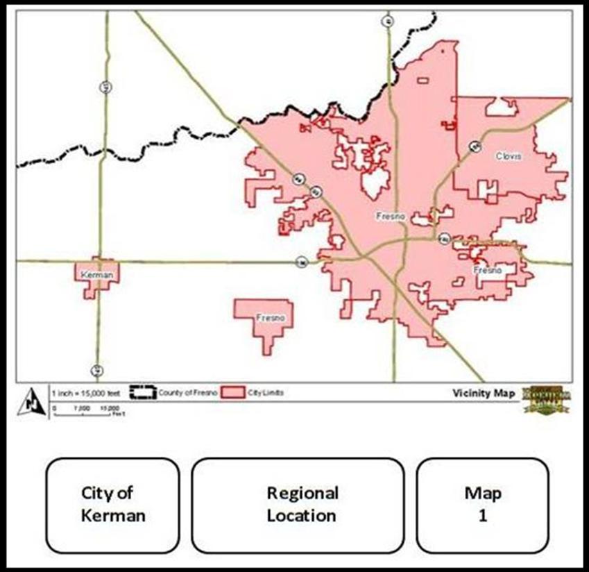
2 The project could have a significant impact on the environment, however mitigation measures have been devised that will minimize those potential impacts to a level that is considered "less than significant". A Mitigated Negative Declaration is prepared to adopt the findings of the study. The project will have a significant impact on the environment and an Environmental Impact Report (EIR) must be prepared. An EIR is an in-depth discussion of the project and its impacts. Mitigation measures that can reduce the magnitude of the impacts must also be discussed. The EIR must also examine alternatives to the project that may or may not reduce environmental impacts. These alternatives could include an alternative site or a different way to design the project. The EIR must also discuss "cumulative impacts" which are impacts that will occur when the project is considered along with other development in the area or the region that may be occurring in the same time frame. Within an EIR, impacts that cannot be reduced to a level that is "less than significant" must be acknowledged. When considering these impacts the decision-making body (in this case, the Planning Commission) must consider and adopt a "Statement of Overriding Considerations" - a statement contained in a resolution that finds that the benefits of the project outweigh its negative environmental effects. Environmental analysis must be conducted before the decision-making body can take action on the project itself - in this case, a land use/zoning amendments and a tentative subdivision map. Public Review CEQA requires the environmental analysis to be made available for public review. This allows members of the public, individuals, and property owners and potentially affected public agencies to review the findings of the study. The review period for this is 20 days. Individuals and agencies may submit comments on the study during the public review period. The City will be responsible for preparing written responses on any comment letters or phone calls received during the review process. The Planning Commission must consider the findings of the IES in a public hearing. Any person may speak on the environmental study at the public hearing and the decision-making bodies must consider any comments. If, after taking testimony from the public, considering written comments submitted during the public review period, and considering the environmental study itself, the decision-making body feels that the findings of the study are correct, they may then adopt the findings of the study. If however, the decision-making body feels the study does not adequately analyze and document the project, it may require additional study. What is a "Significant Impact? The word "significant" is a subjective term; however CEQA contains a list of impacts that are normally considered to be "significant". Impacts most commonly found to be significant for development projects in Valley communities include: 2
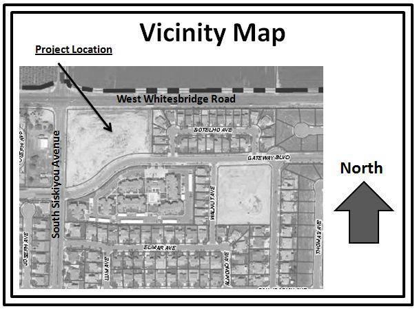
3 Loss of prime farmland Impacts to air quality Loss of endangered plant and animal species Exceeding capacity of infrastructure systems - local water or sewer systems Impacts/overdraft of groundwater Traffic/circulation Public services Growth-inducing impacts Cumulative impacts This list is not all-inclusive - impacts will vary depending on the nature of a specific project, its site and surroundings. It should also be noted that if an impact was acknowledged as significant in a previous environmental document, a subsequent EIR is not typically required. 2.0 PROJECT INFORMATION 2.1 Location The is located in Fresno County. The majority of the city is located on the south side of West Whitesbridge Avenue/Highway 180. The is located in the northwest part of Fresno County in the central San Joaquin Valley of California (see Map 1 Regional Location). The is located approximately seventeen (17) miles west of the City of Fresno, the largest city in Fresno County and the county seat. The project site (see Map 2 Vicinity Map) includes one parcel of land totalling approximately 4.38 acres, located on the southeast corner of West Whitesbridge Avenue and Siskiyou Avenue. 2.2 Project Description The project involves a request for a General Plan Amendment, Change of Zoned, Site Plan Review, and a Development Agreement for construction of an income qualified multi-family residential development (Exhibit 1). Existing General Plan Map Designations The 2007 Kerman General Plan shows the property designated Neighbourhood Commercial. The site is currently zoned "Neighbourhood Commercial". Property to the east and west of the subject property is designated "Medium Density Residential" and zoned R-1-7. Property to the south is designated High Density Residential and zoned Smart Development RM-2.5. The property to the north is designated Medium Density Residential and is located outside the city limits and is not zoned. 3
4 Map 2 4

5 Exhibit 1 Proposed Site Plan Proposed Project Design The proposed project is a sixty-one (61) unit affordable apartment complex. The project is situated on a 4.38 acre parcel on the south east corner of Whitesbridge Road and Siskiyou Avenue. The Kerman General Plan designates Land surrounding the subject property as follows: North: Medium Density Residential South: High Density Residential West: Medium Density Residential East: Medium Density Residential 5

6 Zoning on surrounding properties is as follows: North: Outside City Limits Fresno County South: Smart Development RM 2.5 West: R-1-7 East: R Existing Land Use The subject property is currently vacant. Land east and west is occupied residential uses. Land to the south is occupied by an affordable apartment complex, and land to the north is vacant. The aerial photo in Map 3 shows existing land uses. Map 3: Aerial Photo 6
7 3.0 PROJECT SETTING 3.1 Population Kerman s population is approximately 14, Traffic and Circulation The subject site has access from Siskiyou Avenue and Gateway Boulevard. There are curbs and gutters on both sides of the roadways. Siskiyou Avenue is an arterial street. This roadway connects to Whitesbridge Road which is an expressway. 3.3 Utilities Sewer The provides sewer service to most developed properties within its city limits. The existing system to serve the project site is an existing 8- inch collection line in Gateway Boulevard that connects to an existing 12- inch mains in Siskiyou Avenue. Kerman s WWTP is currently operating at a capacity of 51%. Water The provides water service to most developed properties within its city limits. The project site can be served by existing 12- inch mains in Gateway Boulevard and Siskiyou Avenue. Storm Drainage Storm drainage within the City is provided by the. For the proposed project, storm water will be collected in site and will be channelled to a Lion s Park basin located southeast of the site. This existing basin has ample capacity to handle the runoff generated by the subdivision. Gas and Electricity Pacific Gas and Electric provides electrical service in Kerman (as well as the project area), while Southern California Gas Company supplies natural gas. 7
8 3.4 Biological Resources A known rare and endangered species that may to occur outside the Kerman SOI is the San Joaquin Kit Fox (SJKF), a federally endangered species. None have been sighted in the area. If the SJKF were to be in the area, it is unlikely they would be south of West Whitesbridge Road where there is contiguous urbanization. 3.5 Geological Hazards Kerman is not located within close proximity to a known earthquake fault. According to the Five County Seismic Safety Element (FCSSE), the project site is located within the V1 zone. The FCSSE states that the V1 zone: Includes most of the eastern San Joaquin Valley, and is characterized by a relatively thin section of sedimentary rock overlying a granitic basement. Amplification of shaking that would affect low to medium-rise buildings is relatively high, but the distance to either of the faults that are the expected sources of the shaking is sufficiently great that the effects should be minimal. The requirements of Zone II of the Uniform Building Code should be adequate for normal facilities. This data indicates that Kerman is located in a lower risk area in terms of earthquake activity. Building standards contained in the Uniform Building Code for Zone II should be adequate for protection from earthquake events in Kerman. 3.6 Flooding Kerman is The proposed project is within located within Flood Zone X, as determined by the Flood Insurance Rate map for the Kerman area. Zone X is the area determined to be outside the 500 year flood area. 3.7 Soils There are three (3) soil types on the subject site, according to soil maps maintained by the US Department of Agriculture Soil Conservation Service. 1. HMS Hesperia Sandy Loam, Moderately Deep 2. HA Hanford Course Sandy Loam 3. TzbA Tujanga Loamy Sand, 0-3% Slope. 8