JOINT PUBLIC NOTICE. Village of Milan (Village) Attn: Marcella Sandoval, Village Manager 623 Uranium Avenue Milan, New Mexico 87021
|
|
|
- Lionel Casey
- 5 years ago
- Views:
Transcription

 and the New Mexico Environment Department s Surface Water Quality Bureau (SWQB) are evaluating an application for the Milan Tract Farms Flood")
1 Albuquerque District JOINT PUBLIC NOTICE Application Number: SPA ABQ Date: December 1, 2015 Comments Due: December 31, 2015 SUBJECT: The U.S. Army Corps of Engineers, Albuquerque District, (Corps) and the New Mexico Environment Department s Surface Water Quality Bureau (SWQB) are evaluating an application for the Milan Tract Farms Flood Control Diversion Channel Project on the Rio San Jose, located in Milan, Cibola County, New Mexico. The proposed project would result in impacts to approximately 4.65 acres of waters of the United States in the Rio San Jose. This notice is to inform interested parties of the proposed activity and to solicit comments. AUTHORITY: This application is being evaluated under Sections 404 and 401 of the Clean Water Act (CWA) for the discharge of dredged or fill material in waters of the United States (U.S.). State water quality certification is provided under the authority of New Mexico Administrative Code. APPLICANT: AGENT: Village of Milan (Village) Attn: Marcella Sandoval, Village Manager 623 Uranium Avenue Milan, New Mexico Theresa Knoblock Tierra Right of Way 1575 E. River Road, Suite 201 Tucson, Arizona LOCATION: The project site is located on the Rio San Jose, at Latitude , Longitude , Milan, Cibola County, New Mexico (Figure 1). PROJECT DESCRIPTION: The Village proposes to construct a flood control project (Project) along approximately 9581 linear feet of the Rio San Jose within the Village of Milan. The Project would include: 1
2 1. Relocation of the existing river segment between Mills and Nursery Road and filling in the original channel; and 2. Excavation of a new portion of channel west of the existing along Nursery Road. The existing channel is 14 feet wide from toe to toe of the channel slope with an average depth of four feet from the top of bank to the channel bottom. The proposed channel width is 80 feet wide with an average depth of seven feet. Channel bank armoring in the form of riprap would be placed at all channel turning points. A low-flow channel would be allowed to form within the 80-foot channel bottom. The Project would impact 4.65 acres of waters of the U.S. (Preliminary Jurisdictional Delineation). The Village has stated the basic project purpose is flood control and the overall project purpose is to reduce flood risk in the vicinity of the Rio San Jose. Further refinements of the overall project purpose may be developed by the Corps during the project evaluation. The Village believes there is a need to reduce flood risk to the properties adjacent to the Rio San Jose and accommodate the 100-year flood event within the channel of the proposed project. The attached drawings provide additional project details. PROPOSED MITIGATION: The Village proposes to allow the Rio San Jose to develop natural stream morphology and riparian habitat within the 80-foot flood control channel. The Village proposes to balance operation and maintenance needs with the formation and management of riparian habitat. Note that the existing channel is currently ephemeral and does not support native riparian habitat. ADDITIONAL INFORMATION: Environmental Setting. There are approximately 4.65 acres of the Rio San Jose that are waters of the U.S. within the proposed project area. This reach of the Rio San Jose is generally ephemeral, flowing only in response to rain events. A biological assessment conducted by Tierra Right-of-Way Services, Inc. (Biological Assessment for the Proposed Milan Tract Farms Flood Control Diversion Channel Project, October 2015) for the Village indicate there is minimal natural habitat in the vicinity of the Project. Vegetation is limited and consists of upland or invasive species, including rabbitbrush (Chrysothamnus nauseosus), four-wing salt bush (Atriplex canescens), salt cedar (Tamarisk pentandra), kochia (Kochia scoparia), Russian thistle (Salsola kali) and Siberian elm (Ulmus pumila). Species or species sign observed included only gopher mounds (Thomomys sp), coyote scat (Canis latrans), and Gunnison s prairie dog (Cynomys gunnisoni). The Rio San Jose has been relocated from the earliest recorded maps (GLO Maps from 1873), and is currently feet east of the original channel alignment. Local, non-engineered channelization has reduced the stream functions and services to primarily flow and sediment conveyance and moderate infiltration. Existing land use is primarily fallow agricultural to the north, east and west of the Project. There is urban residential development to the south and southeast. 2
3 Alternatives. The Village has provided information concerning project alternatives and include the following: 1. No work within waters of the U.S.: As the Project is water dependent, a no work within waters of the U.S. alternative would effectively be a No Project alternative (Alternative Widen and protect in place: In this alternative, the village would only enlarge the existing Rio San Jose channel, reducing the 100-year floodplain but not confining it to the constructed channel. The Rio San Jose would remain in its current location, with levees on both sides (Alternative 2) 3. Realign channel (Applicant preferred alternative): For this alternative, the Village would realign the channel and widen it to 80 feet, adding riprap slope protection at channel turns. The Rio San Jose would be allowed to develop an interior lowflow channel and establish riparian habitat naturally (Alternative 3). 4. Realign channel and create a low-flow channel: In this alternative, the Village would not only create the relocated 80-foot wide channel, but would also design a low-flow channel for the Rio San Jose instead of allowing the low-flow channel to develop over time (Alternative 4). Other alternatives may develop during the review process for this permit application. All reasonable project alternatives, in particular those which may be less damaging to the aquatic environment, will be considered. EVALUATION FACTORS: The decision whether to issue a permit will be based on an evaluation of the probable impacts, including cumulative impacts, of the described activity on the public interest. That decision will reflect the national concern for both protection and utilization of important resources. The benefit, which reasonably may be expected to accrue from the described activity, must be balanced against its reasonably foreseeable detriments. All factors which may be relevant to the described activity will be considered, including the cumulative effects thereof; among those are conservation, economics, aesthetics, general environmental concerns, wetlands, historic properties, fish and wildlife values, flood hazards, floodplain values, land use, navigation, shoreline erosion and accretion, recreation, water supply and conservation, water quality, energy needs, safety, food and fiber production, mineral needs, consideration of property ownership and, in general, the needs and welfare of the people. The activity's impact on the public interest will include application of the Section 404(b)(1) guidelines promulgated by the Administrator, Environmental Protection Agency (40 CFR Part 230). HISTORIC PROPERTIES: The Corps consulted district files and records, the latest version of the National Register of Historic Places (NRHP), and state records of NRHPeligible and potentially eligible historic properties to determine if there are any historic properties that may be affected by the proposed undertaking. Additionally, the project area has been recently surveyed for historic properties. Based on this initial information, the 3
4 Corps has made a determination that the proposed project will not adversely affect historic properties. Regardless the Corps will consult with the New Mexico State Historic Preservation Officer regarding the Project. ENDANGERED SPECIES: The Corps has reviewed the U.S. Fish and Wildlife Service's latest published version of Federally-listed endangered and threatened species located in Cibola County, New Mexico to determine if any listed species or their critical habitat may occur in the proposed project area. Based upon this review and the submitted biological assessment, the Corps has made a preliminary determination that the proposed project will not affect any Federally-listed endangered or threatened species or their critical habitat protected by the Endangered Species Act. FLOODPLAIN MANAGEMENT: The Corps is sending a copy of this public notice to the local floodplain administrator. In accordance with 44 CFR part 60 (Flood Plain Management Regulations Criteria for Land Management and Use), the floodplain administrators of participating communities are required to review all proposed development to determine if a floodplain development permit is required and maintain records of such review. COMMENT SUBMITTAL AND DEADLINES: The Corps and SWQB are soliciting comments from all interested parties in to consider and evaluate the impacts of this proposed activity. Any comments received will be considered to determine whether to issue, issue with special conditions, or deny a permit for this proposal. Submittal of Corps Permit Application Comments: All comments regarding the Corps permit application for the above-described project must be received on or before December 31, 2015, which is the close of the comment period. Comments on state Section 401 certification must be submitted as described below under Water Quality Certification Comments. Extensions of the comment period may be granted for valid reasons provided a written request is received by the limiting date. If no comments are received by that date, it will be considered that there are no objections. Anyone may request, in writing, that a public hearing be held to consider this application. Requests shall specifically state the particular reason(s) for holding a public hearing. If the Corps determines that the information received in response to this notice is inadequate for thorough evaluation, a public hearing may be warranted. If a public hearing is warranted, interested parties will be notified of the time, date, and location. Comments and requests for additional information on the Corps permitting action should be submitted to: Deanna L. Cummings, Senior Project Manager US Army Corps of Engineers, Albuquerque District 4101 Jefferson Plaza NE Albuquerque, New Mexico Deanna.L.Cummings@usace.army.mil Submittal of Water Quality Certification Comments: Section 401 requires that any applicant for an individual Section 404 permit provide proof of water quality 4
5 certification to the Corps prior to permit issuance. For the above described project, the applicant is required to obtain water quality certification, under Section 401 of the CWA, from the SWQB. This notice serves to notify the public that the SWQB will consider issuing a certification under Section 401 of the CWA. The purpose of such certification is to reasonably ensure that the permitted activities will be conducted in a manner compliant with applicable New Mexico water quality standards, including the antidegradation policy, and the statewide water quality management plan. This Notice, including notice of the 30-day public comment period, is also posted on the SWQB website at: SWQB will accept and consider written comments regarding the state certification received during the public comment period. Comments may be submitted electronically or by hard copy to: Greg Kaufman New Mexico Environment Department SWQB P.O. Box 5469 Santa Fe, NM FAX greg.kaufman@state.nm.us Please note that names and addresses of those who submit comments in response to this public notice may be made publicly available through the Freedom of Information Act, the New Mexico Inspection of Public Records Act, or both. DISTRICT ENGINEER ALBUQUERQUE DISTRICT CORPS OF ENGINEERS BUREAU CHIEF SURFACE WATER QUALITY BUREAU NEW MEXICO ENVIRONMENT DEPT 5

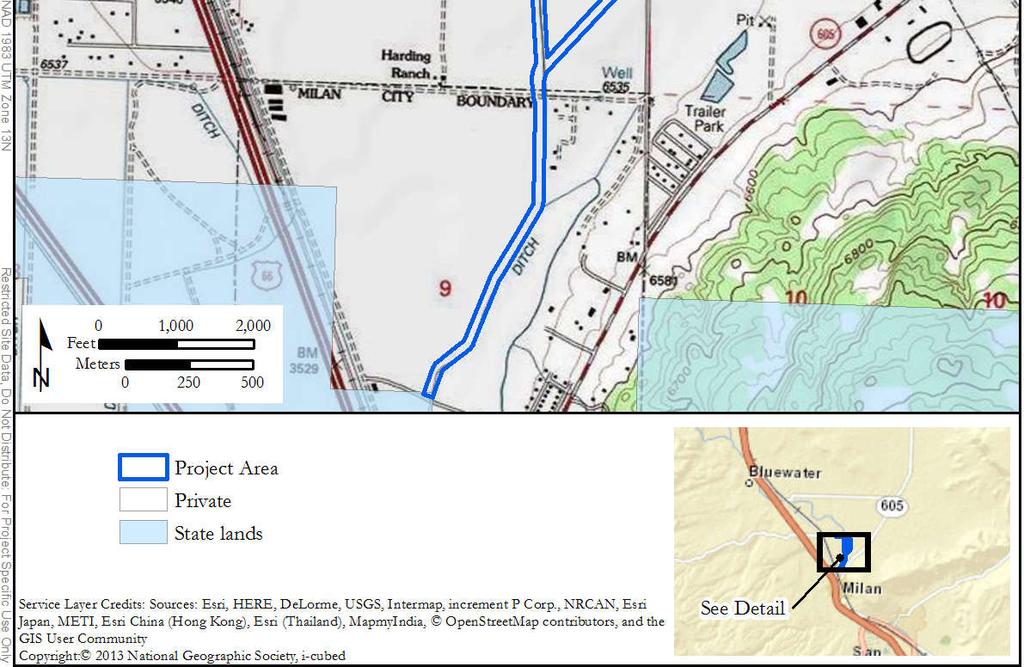
6 Figure 1. Project Location.
7
8
9
10
11