The Collaborative Quest for Water Quality: Teaming Towns and Engineers for Assessment, Selection, and Construction of Stormwater Management Practices
|
|
|
- Tyler Pitts
- 5 years ago
- Views:
Transcription


1 The Collaborative Quest for Water Quality: Teaming Towns and Engineers for Assessment, Selection, and Construction of Stormwater Management Practices 2017 Maine Stormwater Conference, Portland Maine Taylor Walter, Staff Engineer CPESC-IT, Geosyntec Consultants Dan Van Schalkwyk, P.E., Ayer Town Engineer


2 Town of Ayer, Massachusetts Located in Central Massachusetts Population 7, square miles MS4 Community

3 Town of Ayer, Massachusetts


4 Town of Ayer, Massachusetts Ayer Water Resources Facts Ayer community has strong desire to manage ponds Popular swimming and recreational parks Approximately 6% of land area is water
 Dam Inspection and Safety Pond Condition and Maintenance Department of Public Works Stormwater Management Education and Outreach Mapping and Water Quality Monitoring MS4")
5 Local Government Boards and Committees supporting Water Resources: Conservation Commission Wetland Preservation Pond & Dam Management Committee Friends of Flannagan Pond (Resident Group) Dam Inspection and Safety Pond Condition and Maintenance Department of Public Works Stormwater Management Education and Outreach Mapping and Water Quality Monitoring MS4 Steward

6 Stormwater Regulations for Ayer EPA s Phase II Stormwater Rule Similar rules apply to towns and cities nationwide Requires Ayer to develop a stormwater management program Public Education, Participation, and Outreach Regulation of illicit discharges to existing storm drainage systems Regulation of stormwater runoff from construction/land disturbance EPA s Phase II Stormwater Rule provides Ayer with: Greater control of surface water and groundwater resources Ensures Ayer s ponds and streams are protected in the face of increasing development

7 Drivers for Change and Ramp up Conservation Commission Received Resident Complaints Residents stress pond aesthetics Restoration became the conversation Conservation Commission Requested Master Plan from DPW DPW tasked with developing water quality improvement plan Focus to improve public perception and awareness Data Deficit No baseline data for ponds, streams, and dams Partial data for age and location of stormwater network


8 Drivers for Change and Ramp Up DPW Tasked with Mining Available Data Studied local newspaper archive for Infrastructure Age Dams Roads Stormwater Pipe Network Developed an outline for Master Plan Approved Budget in Town Meeting Ignited town s commitment to stormwater improvements


9 Expanding Baseline Understanding DPW worked to fill as much data gaps as possible Acknowledged need for outside consultant Conservation Commission Goal: Establish an updated, scientific basis for the long term management of important ecological and recreational resources

 Water Quality Sampling")

10 Project Overview Aquatic Vegetation Study Balch Pond Grove Pond Watershed Investigation 5 Year Management Plan ( ) Water Quality Sampling Lower Long Pond Pine Meadow Pond Sandy Pond Flannagan Pond Water Quality Modeling


11 Aquatic Vegetation Assessment Provide Baseline for Tracking Track nonnatives and Invasives for control Aquatic Vegetation Assessment Locate Beneficial Species Track species abundance and composition

12 Aquatic Vegetation Assessment


13 Water Quality Sampling Temperature / Dissolved Oxygen Chlorophyll a Specific Conductance Lab Analysis Ammonia Nitrogen Baseline Water Quality ph In situ Total Phosphorus Secchi Disk Clarity

14 Water Quality Sampling Multi Use Parameter Sampler Recommended for Temp, D.O., ph, Conductivity User friendly sampling with training
15 Water Quality Modeling Modeling a Phosphorus Budget for Pond Nutrient Management P transported to waterways during storm events Model pathways and determine loading with land characteristics Topography Land Use, Impervious Cover

16 Water Quality Modeling Modeling a Phosphorus Budget for Pond Management Phosphorus is also transported to ponds via: Aerial Deposition Leaking Septic Systems

17 Water Quality Modeling Grove Pond
18 Water Quality Modeling Modeling Phosphorus Loading and In Lake Phosphorus Evaluating average annual in lake concentration Useful for predicting eutrophic state of lake USEPA Gold Book Standard determines that a lake is eutrophic with in lake P concentration of 25 µg/l Vollenwieder Equation provides reasonable estimate of P dynamics
19 Water Quality Modeling Vollenwieder Method Calculates in lake P (mg/l) as a function of: Annual P loading (land use/aerial deposition/septic) Average Lake Depth Hydraulic Residence Time

20 Water Quality Modeling Vollenwieder Method

21 Pollutant Load Reduction Goals Vollenwieder Method can help target P load reduction goals Example Reduce Annual in lake P by 10% P Loading: 255 lbs/yr In Lake P: 19.3µg/L 0.10 * 255 lb/yr = 25.5 lb/yr 10% Annual Reduction of P loading would drive In lake P concentration to 17.4 µg/l
22 Water Quality Modeling
23 Watershed Investigations

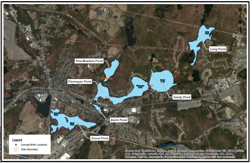
24 Watershed Investigations 14 Stormwater BMP Sites Proposed Key Factors Site Summary Target Watershed Estimated Costs Engineering Design Construction Estimate P reduction O & M Costs

25 5-Year Management Plan

26 5-Year Management Plan

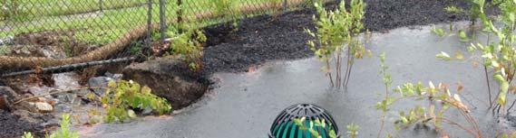
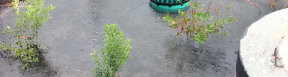
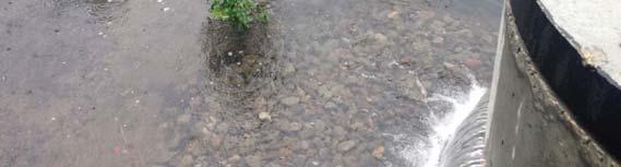
27 Implementing The Plan DPW is following the Water Quality Sampling Plan In situ testing Selected BMPs Retrofits from the Watershed Investigation Retained Geosyntec for design and build services Hydrodynamic Separator Bioretention Cell

28 Pirone Park Bioretention Cell


29 Lessons Learned

30 What s Next? DPW continues to fill data gaps GIS Mapping of Storm Sewer Systems Culverts Catch Basins Outfalls Outfall and Culvert inspection Public Outreach Flyers and Brochures
31 What s Next? Ayer Submitted a 319 Grant for funding for the installation of additional Stormwater Retrofit BMPs Continuing water quality monitoring to evaluate performance of installed BMPs and watershed management Actively monitor recently installed BMPs to develop better understanding of maintenance and performance Municipal Separate Storm Sewer System requires Ayer to Submit Stormwater Management Plan by July 1 st 2018

32 Thank you for Listening! Links: Ayer Ponds Report Ayer Department of Public Works Geosyntec Consultants