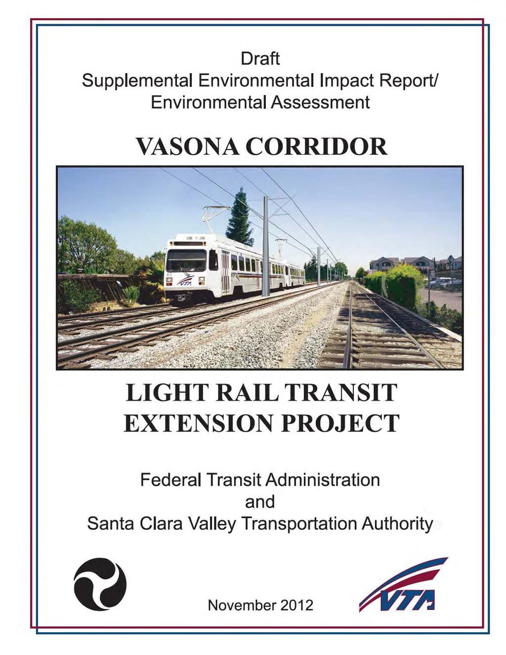
Executive Summary... v
|
|
|
- Lillian Dixon
- 5 years ago
- Views:
Transcription
1
2 Table of Contents Executive Summary... v Chapter 1: Introduction/Purpose and Need. 1 Section 1.1 Introduction and Background Evaluation of Previously Approved Changes to the Project Evaluation of Proposed Changes to the Project... 2 Section 1.2 Organization of the SEIR/EA.. 3 Section 1.3 Statement of Purpose and Need/Project Objectives.. 3 Section 1.4 Uses of the SEIR/EA... 5 Chapter 2: Proposed Action Section 2.1 Overview of the Approved Project. 7 Section 2.2 Proposed Changes to the Approved Project Design Change 1 Vasona Corridor LRT Extension Design Change 2 Winchester Station Design Change 3 Hacienda Station Design Change 4 Vasona Junction Station Design Change 5 Existing Station Platform Extensions Required Right of Way Acquisition Updated LRT Ridership Projections.. 23 Section 2.3 Construction Staging Areas. 23 Chapter 3: Consistency with Adopted Plans and Policies Section 3.1 California Senate Bill SB Section 3.2 State Climate Change Strategies and Policies 24 Section 3.3 Bay Area 2010 Clean Air Plan 25 Section 3.4 Santa Clara VTA Transportation Plan Section 3.5 City of Campbell General Plan 26 Section 3.6 Town of Los Gatos General Plan Chapter 4: Environmental Setting, Impacts, & Mitigation Section 4.1 Land Use 27 Section 4.2 Aesthetics/Visual Section 4.3 Geology and Soils. 46 Section 4.4 Hydrology and Water Quality.. 48 Section 4.5 Biological Resources 59 Section 4.6 Hazards and Hazardous Materials 70 Section 4.7 Cultural Resources.. 79 Section 4.8 Transportation and Circulation 88 Section 4.9 Air Quality. 110 Section 4.10 Energy Section 4.11 Greenhouse Gas Emissions. 131 Section 4.12 Noise and Vibration. 137 Section 4.13 Environmental Justice.149 Vasona Corridor Light Rail Transit Extension i Draft SEIR/EA Santa Clara County, California November 2012
3 Chapter 5: Draft Section 4(f) Evaluation. 153 Chapter 6: Cumulative Impacts..157 Chapter 7: Significant Unavoidable Impacts Chapter 8: Scoping and Coordination..161 Chapter 9: List of Preparers 162 Chapter 10: References Technical Appendices (Provided on a CD at the back of this document) Appendix A Appendix B Appendix C Appendix D Appendix E Appendix F Appendix G Appendix H Appendix I Appendix J Appendix K Vasona Technology Park Parking Survey Hydrology and Water Quality Assessment Biological Assessment Tree Survey Hazardous Materials Technical Report State Office of Historic Preservation Concurrence Letter Transportation Impact Analysis Air Quality Analysis Noise and Vibration Analysis 4(f) Concurrence Town of Los Gatos Notice of Preparation/Comment Letters Vasona Corridor Light Rail Transit Extension ii Draft SEIR/EA Santa Clara County, California November 2012
4 List of Figures 1 Regional Map and VTA Light Rail System 8 2 Proposed Project Alignment 9 3 Project Alignment Detail View Project Alignment Detail View Project Alignment Detail View Project Alignment Detail View Project Alignment Detail View Project Alignment Detail View Winchester Station Plan Hacienda Optional Park and Ride Plan Vasona Junction Park and Ride Plan Aerial of Vasona Junction Project Site Aerial of Hacienda Project Site Aerial of Winchester Project Site Photosimulations View Point Locations Photosimulation View Photosimulation View Tree Map Existing Bicycle Facilities Existing Transit Services Study Intersections Census Tracts Vasona Corridor Light Rail Transit Extension iii Draft SEIR/EA Santa Clara County, California November 2012
5 List of Tables 1 Right-of-Way Acquisitions 22 2 Existing and Projected Daily Boardings 23 3 Replacement Ratios for Trees Impacted by the Project Tree Survey 65 5 Existing Transit Service 89 6 Signalized Intersection Levels of Service Definitions Based on Delay 92 7 Existing Intersection Level of Service 93 8 Year 2011 Project Trip Generation Estimates Year 2011 Intersection Levels of Service Year 2011 VMT/VHT Projections for Santa Clara County Year 2015 Project Trip Generation Estimates Year 2015 Intersection Levels of Service Year 2015 VMT/VHT Projections for Santa Clara County Year 2035 Project Trip Generation Estimates Year 2035 Intersection Levels of Service Year 2035 VMT/VHT Projections for Santa Clara County Major Criteria Pollutants Federal and State Ambient Air Quality Standards Number of Ambient Air Quality Standards Violations ( ) Comparison of Countywide Daily VMT With and Without the Project Estimated Operational Emissions in Pounds Per Day for Santa Clara County Estimated Localized Emissions in Project Construction Emissions in Pounds Per Day Net Energy Use with the Project in Millions of BTUs Per Day Estimated Countywide GHG Emissions from Mobile Sources Net GHG Emissions from the Proposed Project FTA Transit Noise Impact Thresholds FTA Vibration Impact Criteria Comparison of 1999 and 2009 Ambient Noise Exposure Levels Noise Impacts from LRT Operations Groundborne LRT Vibration Impacts from the Proposed Project Groundborne Freight Vibration Impacts from the Proposed Project Existing Demographics in the Project Study Area and in Santa Clara County Cumulative Noise Impacts Year Vasona Corridor Light Rail Transit Extension iv Draft SEIR/EA Santa Clara County, California November 2012
6 Executive Summary Summary Description of the Proposed Project The Vasona Corridor Light Rail Transit (LRT) Project was a 6.8-mile extension of Santa Clara County s LRT system from downtown San José through the City of Campbell and into the Town of Los Gatos. The project was approved in Subsequent to its approval, the project was constructed between downtown San José and the Winchester Station in Campbell. The southernmost portion of the project (i.e., the 1.6-mile segment between the Winchester Station and the Vasona Junction Station in Los Gatos) was not constructed due to lack of sufficient funding. The proposed Vasona Corridor LRT Extension Project would complete the originally planned Vasona Corridor with a 1.6-mile extension of the Vasona LRT Line. The extension would begin at the existing Winchester Station in Campbell and continue within the VTA right-of-way to the Town of Los Gatos. A number of design changes to the approved project are now proposed. Proposed changes to the approved project are as follows: 1. Construction of a double set of LRT tracks from Winchester Station to Vasona Junction Station and relocating the existing freight track east of the new LRT tracks within the existing right-of-way; 2. Expansion of the park-and-ride lot and bus transit center at the Winchester Station; 3. Installation of an electrical power substation at the southeast corner of the expanded Winchester Station park-and-ride lot; 4. Construction of an at-grade pedestrian crossing east of the Winchester Station to provide access to the station from the adjacent Avalon Campbell Apartments. 5. Construction of the Hacienda Station in the originally identified location with an optional park-and-ride lot at the northeast corner of Winchester Boulevard and Hacienda Avenue; 6. Construction of the Vasona Junction Station in the originally identified location and construction of a park-and-ride lot on an adjacent parcel currently owned by the Santa Clara Valley Water District; 7. Installation of an electrical power substation of the west side of Winchester Boulevard, immediately south of the SR 85 on-ramp; and 8. Extension of six of the eight existing LRT station platforms along the Vasona Corridor (Winchester, Campbell, Hamilton, Bascom, Fruitdale, and Race Street) to 280 feet to accommodate three-car trains. Vasona Corridor Light Rail Transit Extension v Draft SEIR/EA Santa Clara County, California November 2012
7 The Vasona Corridor LRT Extension Project would be implemented in two phases based on funding and projected ridership. Phase 1 would include all project features listed above except the Hacienda Station and optional Hacienda park-and-ride lot. The Hacienda Station (with or without the park-and-ride lot) would be constructed in Phase 2, contingent on sufficient funding and ridership. A detailed project description is provided in Chapter 2.0 of this document. The project is included in the adopted Santa Clara Valley Transportation Plan 2035 (VTP 2035), as well as the adopted San Francisco Bay Regional Transportation Plan 2035 (T-2035). Per the T-2035 Plan, the estimated capital cost to construct the Vasona Corridor LRT Extension Project is $146 million. Funding for the project will include the Measure A Program, which is a local ½-cent sales tax designated for transportation improvement projects. Other funding sources have yet to be determined, but may include a combination of federal and/or state transportation monies. Summary of Environmental Impacts and Mitigation The following discussion summarizes the environmental impacts of the proposed Vasona Corridor LRT Extension Project. A detailed discussion of the environmental setting, impacts, and mitigation measures is provided in Chapter 4.0 of this document. Since this is a joint NEPA and CEQA document, the analysis of each subject in this document concludes with both a NEPA finding and a CEQA determination. When discussing NEPA findings, the terminology used in this analysis includes no adverse effect and adverse effect. When discussing CEQA determinations, the terminology used in this analysis includes no impact, less than significant impact, and significant impact. Environmental Impacts Mitigation Measures Land Use The proposed project is compatible with all No mitigation is required. surrounding land uses. Less Than Significant Impact per CEQA; No Adverse Effect per NEPA (See Section ) The proposed project will not disrupt or divide an established neighborhood community. No Impact per CEQA; No Effect per NEPA (See Section ) No mitigation is required. Vasona Corridor Light Rail Transit Extension vi Draft SEIR/EA Santa Clara County, California November 2012
8 Environmental Impacts Mitigation Measures Land Use The proposed project would result in the No mitigation is required. loss of up to nine businesses. The affected properties would be purchased at fair market value and the VTA s Relocation Program would be implemented. Less Than Significant Impact per CEQA; No Adverse Effect per NEPA (See Section ) The project has been designed to avoid conflicts with existing SCVWD facilities that are necessary for water supply management and distribution. Less Than Significant Impact per CEQA; No Adverse Effect per NEPA (See Section ) No mitigation is required. Aesthetics/Visual Expansion of the existing Winchester parkand-ride lot will not result in a significant No mitigation is required. visual impact. Less Than Significant Impact per CEQA; No Adverse Effect per NEPA (See Section ) The loss of trees along the project alignment would not be a significant visual impact. Less Than Significant Impact per CEQA; No Adverse Effect per NEPA (See Section ) No mitigation is required. Geology and Soils Seismic impacts would be less than No mitigation is required. significant because the project will utilize standard engineering techniques mandated by the Uniform Building Code. Less Than Significant Impact per CEQA; No Adverse Effect per NEPA (See Section 4.3.3) Hydrology and Water Quality Implementation of the proposed project will No mitigation is required. not subject people or new development to flooding hazards. Less Than Significant Impact per CEQA; No Adverse Effect per NEPA (See Section ) Vasona Corridor Light Rail Transit Extension vii Draft SEIR/EA Santa Clara County, California November 2012
9 Environmental Impacts Mitigation Measures Hydrology and Water Quality Development of the approximately two-acre No mitigation is required. Vasona Junction park-and-ride lot site would not require upgrades to the existing infrastructure to support the project. Less Than Significant Impact per CEQA; No Adverse Effect per NEPA (See Section ) With implementation of a Stormwater Control Plan, the project would not violate any adopted water quality standards or waste discharge requirements. Less Than Significant Impact per CEQA; No Adverse Effect per NEPA (See Section ) The proposed platform extensions would have a less than significant long-term water quality impact. Less Than Significant Impact per CEQA; No Adverse Effect per NEPA (See Section ) Construction of the proposed Vasona Junction park-and-ride lot and optional Hacienda park-and-ride lot could temporarily impact the water quality of Los Gatos Creek. Temporary Significant Impact per CEQA; Adverse Effect per NEPA (See Section ) Relocation of the freight track and installation of the double LRT Tracks would not substantially increase sediment or contaminants entering the local storm drainage system. Less Than Significant Impact per CEQA; No Adverse Effect per NEPA (See Section ) With full compliance of permit regulations, the proposed project will have a less than significant hydromodification impact. Less Than Significant Impact per CEQA; No Adverse Effect per NEPA (See Section ) No mitigation is required. No mitigation is required. Project-specific mitigation measures will be implemented during all phases of construction to reduce construction-related water quality impacts. Less Than Significant Impact With Mitigation per CEQA; No Adverse Effect With Mitigation per NEPA (See Section for the full list of mitigation measures) No mitigation is required. No mitigation is required. Vasona Corridor Light Rail Transit Extension viii Draft SEIR/EA Santa Clara County, California November 2012
10 Environmental Impacts Mitigation Measures Hydrology and Water Quality Even with a substantial increase in No mitigation is required. impervious surfaces on the Vasona Junction park-and-ride lot site, the project would have a less than significant impact on the groundwater aquifer. Less Than Significant Impact per CEQA; No Adverse Effect per NEPA (See Section ) Implementation of the proposed project will not put any persons in danger from inundation due to dam failure. Less Than Significant Impact per CEQA; No Adverse Effect per NEPA (See Section ) No mitigation is required. Implementation of the proposed project would result in the loss of native coast live oak trees that provide habitat for bird species on the Vasona Junction park-andride lot site. Significant Impact per CEQA; Adverse Effect per NEPA (See Section ) Biological Resources The California coast live oak trees on the Vasona Junction park-and-ride lot site (measuring 18 inches in diameter or greater) will be replaced in-kind and on-site at a 5:1 ratio. Replacement trees will be either 15-gallon or 24-inch box specimens and will be purchased from local genetic stock. Replacement trees will be planted along the eastern property line. If there is not sufficient room available to plant all the replacement trees, the trees will be planted as near the riparian corridor as possible. Replacement trees will be irrigated for a minimum of two years. If sufficient planting areas are not available on-site, the oak trees may be planted along the upper banks of the Los Gatos Creek riparian corridor directly adjacent or within close proximity to the Vasona Junction park-and-ride lot site. Less Than Significant Impact With Mitigation per CEQA; No Adverse Effect With Mitigation per NEPA. Implementation of the proposed project would not impact the variety or abundance of native plants within and along the Los Gatos Creek riparian corridor. Not an Impact per CEQA; No Adverse Effect per NEPA (See Section ) Invasive plant species, including those occurring on the California Invasive Plant Council watch list, will not be planted at the Vasona Junction park-and-ride lot site. Per VTA standard practices, native and drought tolerant plant species will be included in the landscape planting design. Less Than Significant With Mitigation per CEQA; No Adverse Effect With Mitigation per NEPA Vasona Corridor Light Rail Transit Extension ix Draft SEIR/EA Santa Clara County, California November 2012
11 Environmental Impacts Mitigation Measures Construction of the proposed Vasona Junction park-and-ride lot during nesting season could result in the loss of individual yellow warblers, their nests, their eggs, and/or the loss of active nests of other bird species. Significant Impact per CEQA; Adverse Effect per NEPA (See Section ) Biological Resources When possible, construction activities will occur outside the breeding season for local bird species, which is February through August. Possible nesting areas (i.e., bushes, trees, grass, burrows) that will be removed as part of the project will be removed between September and January to preclude nesting. If it is not possible to schedule demolition and construction between September and January, preconstruction surveys for nesting birds will be completed by a qualified ornithologist to ensure that no nests will be disturbed during project implementation. If an active nest is found sufficiently close to work areas to be disturbed by construction, the ornithologist, in consultation with CDFG, will determine the extent of a construction-free buffer zone to be established around the nest, typically 250 feet, to ensure that raptor or migratory bird nests will not be disturbed during construction. Less Than Significant with Mitigation per CEQA; No Adverse Effect With Mitigation per NEPA Construction of the proposed Vasona Junction park-and-ride lot could impact the aquatic species occupying Los Gatos Creek. Significant Impact per CEQA; Adverse Effect per NEPA (See Section ) Implementation of the proposed project would increase nighttime light levels near Los Gatos Creek, possibly disrupting wildlife within the riparian corridor. Significant Impact per CEQA; Adverse Effect per NEPA (See Section ) Stormwater control BMP s will be implemented during all phases of construction consistent with the measures listed in Section 4.5, Hydrology and Water Quality of this SEIR/EA. Machinery on-site will not be refueled within 60 feet from the top of the creek bank. A Spill Prevention and Response Plan, which includes appropriate construction worker training, will be developed and implemented during construction. Less Than Significant With Mitigation per CEQA; No Adverse Effect With Mitigation per NEPA Low-glare, low intensity lighting will be used within the Vasona Junction park-and-ride lot and will be shielded to direct light away from the riparian corridor. Lighting elements will be placed as close to ground level as possible while still providing sufficient light for pedestrians, bicyclists, and drivers to maneuver safely through the lot. Landscaping between the Vasona Junction Vasona Corridor Light Rail Transit Extension x Draft SEIR/EA Santa Clara County, California November 2012
12 See Pervious Page Environmental Impacts Mitigation Measures Biological Resources park-and-ride lot and the Los Gatos Creek trail will be designed to screen the riparian corridor and shield it from the on-site lighting. Less Than Significant Impact With Mitigation per CEQA; No Adverse Effect With Mitigation per NEPA Redevelopment of the project sites and rail alignment could expose construction workers to residual contamination in the soil from previous and current land uses. Significant Impact per CEQA; Adverse Effect per NEPA (See Section ) Hazards and Hazardous Materials Soil sampling will be completed along the rail alignment and at the locations for the park-and-ride lots and ancillary facilities. In addition, a Soil Management Plan and Health and Safety Plan will be prepared and implemented during construction. Less Than Significant Impact With Mitigation per CEQA; No Adverse Effect With Mitigation per NEPA (See Section for the full list of mitigation measures) Removal of ACMs in compliance with State law and other applicable regulations will have a less than significant impact on construction workers and nearby building tenants. Less Than Significant Impact per CEQA; No Adverse Effect per NEPA (See Section ) Removal of lead-based paint coated building materials in compliance with State law will have a less than significant impact on construction workers and nearby building tenants. Less Than Significant Impact per CEQA; No Adverse Effect per NEPA (See Section ) No mitigation is required. No mitigation is required. The operation of the LRT trains along the Vasona Corridor will not generate, use, transport, store, or dispose of any hazardous materials. Less Than Significant Impact per CEQA; No Adverse Effect per NEPA (See Section ) No mitigation is required. Vasona Corridor Light Rail Transit Extension xi Draft SEIR/EA Santa Clara County, California November 2012
13 Environmental Impacts Mitigation Measures Hazards and Hazardous Materials Construction workers at the Hacienda No mitigation is required. Station and park-and-ride lot sites would not be exposed to contaminated soil and/or groundwater. Less Than Significant Impact per CEQA; No Adverse Effect per NEPA (See Section ) Construction of the proposed Vasona Junction Station and park-and-ride lot could disturb previously unidentified cultural resources. Significant Impact per CEQA; Adverse Effect per NEPA (See Section ) Cultural Resources Monitoring will occur during initial excavation of the Vasona Junction Station and park-and-ride lot sites. In the event that prehistoric or historic resources or human remains are encountered during excavation and/or grading of the site, all activity within a 30-foot radius of the find will be stopped and the find examined. Less Than Significant Impact With Mitigation per CEQA; No Adverse Effect With Mitigation per NEPA (See Section for the full list of mitigation measures) The Juan Batista de Anza National Historic Trail crosses the southernmost end of the APE. The project will not have any effect on the value for which the trail is listed as a historic resource. Less Than Significant Impact per CEQA; No Adverse Effect per NEPA (See Section ) No historic architectural resources are present within the APE and the project will not result in impacts to such resources. No Impact per CEQA; No Effect per NEPA (See Section ) No mitigation is required. No mitigation is required. Transportation and Circulation The project will not result in any significant No mitigation is required. impacts to any of the 10 study intersections under existing plus project conditions and in horizon years 2015 and Less Than Significant Impact per CEQA; No Adverse Effect per NEPA (See Sections , , and ) Vasona Corridor Light Rail Transit Extension xii Draft SEIR/EA Santa Clara County, California November 2012
14 Environmental Impacts Mitigation Measures Transportation and Circulation The project will reduce overall vehicle miles No mitigation is required. traveled and vehicle hours traveled under existing plus project conditions and in horizon years 2015 and Beneficial Impact under CEQA; Beneficial Effect under NEPA (See Sections , and ) Implementation of the proposed project will not modify, remove, or impede the existing bicycle facilities in the project area. No Impact per CEQA; No Effect per NEPA (See Section 4.8.7) Implementation of the proposed project will not modify, remove, or impeded the existing pedestrian facilities in the project area. No Impact per CEQA; No Effect per NEPA (See Section 4.8.7) The loss of 45 parking spaces along the western property line of the Vasona Technology Park site will not interfere with business operations or result in significant operational issues or loss of business. Less Than Significant Impact per CEQA; No Adverse Effect per NEPA (See Section ) The loss of approximately 50 parking spaces along the western property line of the Netflix site would not interfere with business operations or result in significant operational issues or loss of business. Less Than Significant Impact per CEQA; No Adverse Effect per NEPA (See Section ) No mitigation is required. No mitigation is required. No mitigation is required. No mitigation is required. Air Quality The project would result in an overall No mitigation is required. reduction in criteria pollutant emissions due to a net reduction in vehicle miles traveled and vehicles hours traveled, therefore, the proposed project would have a beneficial operations impact. Beneficial Impact under CEQA; Beneficial Effect under NEPA (See Section ) Vasona Corridor Light Rail Transit Extension xiii Draft SEIR/EA Santa Clara County, California November 2012
15 Environmental Impacts Mitigation Measures Air Quality The project will have a less than significant No mitigation is required. impact on local carbon monoxide concentrations. Less Than Significant Impact per CEQA; No Adverse Effect per NEPA (See Section ) Operation of the LRT stations would have a less than significant impact on localized pollutant levels and sensitive receptors. Less Than Significant Impact per CEQA; No Adverse Effect per NEPA (See Section ) The proposed project would have a less than significant operational toxic air contaminant impact. Less Than Significant Impact per CEQA; No Adverse Effect per NEPA (See Section ) The project would have a less than significant operational odor impact. Less Than Significant Impact per CEQA; No Adverse Effect per NEPA (See Section ) Construction of the proposed project would have a significant air quality impact from NOx emissions. Significant Temporary Impact per CEQA; Adverse Effect per NEPA (See Section ) Construction of the proposed project would not have a significant toxic air contaminant impact. Less Than Significant Impact per CEQA; No Adverse Effect per NEPA (See Section ) Construction of the proposed project would not have a significant asbestos impact from demolition of asbestos-containing materials or grading of soil with naturally occurring asbestos. Less Than Significant Impact per CEQA; No Adverse Effect per NEPA (See Section ) No mitigation is required. No mitigation is required. No mitigation is required. Project-specific mitigation measures, as recommended by the Bay Area Air Quality Management District BMPs, will be implemented to reduce construction-related air quality impacts. Less Than Significant Impact With Mitigation per CEQA; No Adverse Effect With Mitigation per NEPA (See Section for the full list of mitigation measures) No mitigation is required. No mitigation is required. Vasona Corridor Light Rail Transit Extension xiv Draft SEIR/EA Santa Clara County, California November 2012
16 Environmental Impacts Mitigation Measures Air Quality Construction of the proposed project would No mitigation is required. cause a less than significant odor impact. Less Than Significant Impact per CEQA; No Adverse Effect per NEPA (See Section ) Energy Implementation of the project will increase No mitigation is required. the daily electricity used for operation of the LRT line, but the increase will be offset by the decrease in energy usage from reduced VMT. Beneficial Impact under CEQA; Beneficial Effect under NEPA (See Section ) The project will result in a net decrease in energy use from operation of buildings at the project sites. Beneficial Impact under CEQA; Beneficial Effect under NEPA (See Section ) The project will result in an overall net decrease in daily energy use of up to 104 million BTUs by the year 2015 and 229 million BTUs by the year 2035 compared to existing conditions. Beneficial Impact under CEQA; Beneficial Effect under NEPA (See Section ) No mitigation is required. No mitigation is required. Greenhouse Gas Emissions Implementation of the project will result in a No mitigation is required. net reduction in GHG emissions. Beneficial Impact under CEQA; Beneficial Effect under NEPA (See Section ) Noise and Vibration None of the increases in noise due to LRT No mitigation is required. operations would exceed the thresholds for either moderate or severe impacts. Less Than Significant Impact per CEQA; No Adverse Effect per NEPA (See Section ) Vasona Corridor Light Rail Transit Extension xv Draft SEIR/EA Santa Clara County, California November 2012
17 Environmental Impacts Mitigation Measures Noise and Vibration The maximum noise from LRT pass-bys will No mitigation is required. typically range from 65 to 76 db at nearby receptors. This is below the single-event Lmax criterion of 82 dba that has been established for this project. Less Than Significant Impact per CEQA; No Adverse Effect per NEPA (See Section ) The tail tracks at the Vasona Junction Station would be infrequently used. The slow speed of the trains combined with rail lubricators would minimize the wheel squeal effect. Less Than Significant Impact per CEQA; No Adverse Effect per NEPA (See Section ) The expansion of the Winchester Station park-and-ride lot and bus transit center would not exceed FTA thresholds and would not have a significant noise impact on nearby sensitive receptors. Less Than Significant Impact per CEQA; No Adverse Effect per NEPA (See Section ) Inclusion of the optional park-and-ride lot at the Hacienda Station would not exceed FTA thresholds and would not have a significant noise impact on nearby sensitive receptors. Less Than Significant Impact per CEQA; No Adverse Effect per NEPA (See Section ) Operation of the Vasona Junction Station and park-and-ride lot would not exceed FTA thresholds and would not result in a significant noise impact at the closest residences (Aventino Apartments). Less Than Significant Impact per CEQA; No Adverse Effect per NEPA (See Section ) No mitigation is required. No mitigation is required. No mitigation required. No mitigation required. Vasona Corridor Light Rail Transit Extension xvi Draft SEIR/EA Santa Clara County, California November 2012
18 Environmental Impacts Mitigation Measures Noise and Vibration None of the proposed substations would be No mitigation required. located near enough to existing residences or other sensitive receptors to create a noise nuisance of significant noise impact. Less Than Significant Impact per CEQA; No Adverse Effect per NEPA (See Section ) Freight trains traversing the new crossover south of the proposed Vasona Junction Station will not significantly increase the total noise exposure for nearby residences. Less Than Significant Impact per CEQA; No Adverse Effect per NEPA (See Section ) Based on the vibration thresholds established by FTA, extension of the LRT from the existing Winchester Station to the Vasona Junction Station site would have a less than significant vibration impact on surrounding land uses. Less Than Significant Impact per CEQA; No Adverse Effect per NEPA (See Section ) Based on the vibration thresholds established by FTA, relocation of the existing freight line from the existing Winchester Station to the Vasona Junction Station site and the addition of crossover tracks at the Vasona Junction Station site would have a less than significant vibration impact on surrounding land uses. Less Than Significant Impact per CEQA; No Adverse Effect per NEPA (See Section ) Construction of the proposed project will result in significant temporary noise impacts. Significant Temporary Impact per CEQA; Adverse Effect per NEPA (See Section ) No mitigation is required. No mitigation is required. No mitigation is required. Project-specific mitigation measures will be implemented to reduce construction-related noise impacts. Less Than Significant Impact With Mitigation per CEQA; No Adverse Effect With Mitigation per NEPA (See Section for the full list of mitigation measures) Vasona Corridor Light Rail Transit Extension xvii Draft SEIR/EA Santa Clara County, California November 2012
19 Environmental Impacts Mitigation Measures Environmental Justice Impacts of the project would primarily affect No mitigation is required. non-minority and non-low-income populations since they comprise the majority of persons in the study area. The project would not result in disproportionately high impacts to minority or low-income populations. Not an Impact per CEQA; No Adverse Effect per NEPA (See Section ) Areas of Known Controversy Based on comments received during the public scoping meeting and comment letters received on the Notice of Preparation, issues raised on this project include: Use of the Santa Clara Valley Water District property for the Vasona Junction park-and-ride lot; The impact to local businesses due to relocation of the freight line, expansion of the Winchester park-and-ride lot, and construction of the optional Hacienda parkand-ride lot; and Loss of parking at the Netflix facility adjacent to the Vasona Junction station and the Vasona Technology Park adjacent to the Hacienda station. Vasona Corridor Light Rail Transit Extension xviii Draft SEIR/EA Santa Clara County, California November 2012
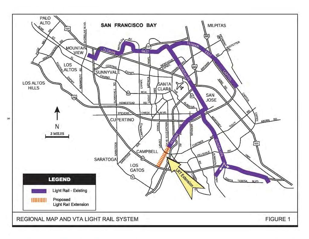
20 Chapter 1.0 Introduction/Purpose and Need 1.1 INTRODUCTION AND BACKGROUND The Vasona Corridor LRT Project was a 6.8-mile extension of Santa Clara County s LRT system from downtown San José through the City of Campbell and into the Town of Los Gatos. The project was approved in 2000 by the Federal Transit Administration (FTA) and the Santa Clara Valley Transportation Authority (VTA). Subsequent to its approval, the project was constructed between downtown San José and the Winchester Station in Campbell. The southernmost portion of the project (i.e., the 1.6-mile segment between the Winchester Station and the Vasona Junction Station in Los Gatos) was not constructed due to lack of sufficient funding. Prior to its approval in 2000, the project was the subject of a combined Environmental Impact Statement/Environmental Impact Report (EIS/EIR) under the National Environmental Policy Act (NEPA) and the California Environmental Quality Act (CEQA) Evaluation of Previously-Approved Changes to the Project Following the completion and approval of the Final EIS/EIR in year 2000, four Reevaluations of the EIS/Addenda to the EIR were prepared to address design changes to the approved project. The first Reevaluation/Addendum, which was approved by VTA in March 2001 and FTA in February 2001, addressed design changes to the proposed Bascom Station in the City of San José. The original project proposed a station and park-and-ride lot at the southwest corner of Stokes Street and Southwest Expressway. The proposed design changes included the following: shifting the location of the station approximately 689 feet south of the intersection; relocating the park-and-ride lot to a vacant parcel along the west side of Southwest Expressway (between Southwest Expressway and the rail tracks); and relocating the Bascom Bus Transfer Facility to the south corner of an existing retail center, requiring the relocation of an existing auto repair shop. The second Reevaluation/Addendum, which was approved by VTA in June 2001 and FTA in July 2001, addressed design changes to the existing SR 87 overcrossing. Prior to construction of the Vasona Corridor, SR 87 crossed over San Carlos Street on two bridges, one for northbound traffic and one for southbound traffic. The original Vasona Corridor project did not propose any major changes to these bridges. The proposed design change under the second Reevaluation/Addendum was to fill the gap between the two existing bridges which would allow future widening of the freeway to accommodate carpool lanes. While the bridge expansion was not required to build and Vasona Corridor Light Rail Transit Extension 1 Draft SEIR/EA Santa Clara County, California November 2012
21 operate the Vasona Corridor LRT, it was determined that combining the two projects (i.e., the bridge expansion and the Vasona Corridor project) would avoid future disruption to LRT operations. The third Reevaluation/Addendum addressed design changes to the Hamilton Avenue rail crossing in the City of Campbell. The original project proposed an at-grade crossing over Hamilton Avenue and an at-grade station on the south side of Hamilton Avenue. Railroad gates, warning lights, and bells would be activated each time a LRT or freight train crossed the roadway. The proposed design changes included the following: construction of an aerial grade separation at the Hamilton Avenue crossing, and elevation of the proposed Hamilton Avenue station above grade. The third Addendum was approved by VTA in March 2002, but FTA concluded that an Environmental Assessment (EA) was warranted under NEPA. The Final EA was completed in December 2002 and FTA issued a Finding of No Significant Impact (FONSI) in March The fourth Reevaluation/Addendum (approved by VTA in May 2003 and FTA in July 2003) addressed design changes to the Winchester Station park-and-ride lot. The original project proposed a parking lot with 123 to 170 parking spaces, a bus transfer facility, break room and restrooms for employees, a drop-off area, and bicycle lockers and racks. The proposed design change reduced the total parking spaces to 54. As a result of the reduced parking, the acquisition of the Summer Winds Nursery property was no longer required Evaluation of Proposed Changes to the Project FTA and VTA are now proposing to complete the remaining 1.6-mile segment of the Vasona Corridor LRT extension. In addition, a number of design changes are also proposed, all of which are described in Section 2.2. Pursuant to Part 23 of the Code of Federal Regulations (CFR), Section (c), this EA has been prepared, which will lead to one of the following outcomes: The project will have a significant impact and, therefore, the preparation of a Supplemental EIS is required; or The project will not have a significant impact and, therefore, a FONSI will be made. To document the effects of the proposed changes to the project, VTA, as the Lead Agency for CEQA, considered preparing an Addendum to the EIR, pursuant to CEQA Guidelines Section After a preliminary review, however, VTA decided to prepare this Supplemental EIR because 1) the number and scope of the changes were such that new and/or greater environmental impacts could potentially result, and 2) the Supplemental EIR process affords the public and other agencies with multiple opportunities to participate in the project review and approval process. Vasona Corridor Light Rail Transit Extension 2 Draft SEIR/EA Santa Clara County, California November 2012
22 Pursuant to FTA NEPA implementation procedures (23 CFR ), Section of the Public Resources Code, and CEQA Guidelines Section , this Supplemental EIR/EA presents information on the design changes to the proposed project. It updates to the environmental analysis based on the design changes since the Final EIS/EIR. No new significant impact or substantial increase in the severity of an environmental impact would occur in the following sections of Final EIS/EIR sections as a result of the design changes. Therefore, these sections were not included in the Supplemental EIR/EA. Alternatives to the Proposed Project Farmlands Wild and Scenic Rivers Magnetic Field Hazards and Interference Utilities and Service Systems Public Services Irreversible Environmental Changes and Irretrievable Commitment of Resources Growth Inducing Impacts The analysis of a project s impact on global climate change is now required by CEQA. This SEIR/EA includes an analysis of greenhouse gas emissions, pursuant to CEQA Guidelines Section , which was not analyzed in the original document. 1.2 ORGANIZATION OF THE SEIR/EA The organization of this document generally follows the organization of the previously approved Vasona Corridor Light Rail Transit Project Final EIS/EIR. 1.3 STATEMENT OF PURPOSE AND NEED/PROJECT OBJECTIVES Pursuant to CEQA Guidelines Section and NEPA Regulations Section 40 CFR , the SEIR/EA must identify the purpose of the project and the discretionary actions required by the Lead Agency. The purpose of the project is stated in the project objectives below. The discretionary actions required are listed under Section 1.4, Uses of the SEIR/EA. The stated objectives of the project are to: Improve public transit service along the Vasona Corridor by providing a quality and accessible public transportation system in the Vasona/State Route (SR) 17 corridor area within the Cities of San José and Campbell, and the Town of Los Gatos that Vasona Corridor Light Rail Transit Extension 3 Draft SEIR/EA Santa Clara County, California November 2012
23 meets the projected growth and associated development in the Vasona Corridor and to meet the transit needs in the corridor. Construct a multi-modal system that would be convenient and would be integrated with other rail and bus service while minimizing environmental effects on existing land uses to the extent practical and would address transportation system deficiencies along the Vasona Corridor. Improve transit service along the Vasona Corridor by providing increased capacity and faster, convenient access to downtown San José and major employment and activity centers. Make transit an attractive alternative for travel along Winchester Boulevard and San Tomas Expressway. Enhance regional connectivity through expanded, interconnected transit services along some of the primary travel corridors in Santa Clara County, including SR 85, U.S. 101 (Guadalupe corridor), and Interstate 680 (Tasman East, Capitol Avenue, and Capitol Expressway corridors). Improve mobility options to employment, education, medical, and retail centers for all corridor residents, particularly low-income, transit dependant, youth, elderly, disabled, and ethnic minority populations. Support local economic and land development goals. Reduce automobile trips, improve air quality by reducing automobile emissions, and provide opportunities for reduction in energy use. Increase parking to relieve overflow conditions at the existing Winchester Station. Create an intermodal transit center that serves as a hub of West Valley services. Need for Vasona Corridor Project The need for the Vasona Corridor Project is driven by the increase in transportation demand from the growth and development in the County, congestion on the existing freeways, expressways, and arterial streets; and regional and local plans and goals. Santa Clara County, often referred to as Silicon Valley, contains many of the nation's high-tech companies. The growth of that industry has resulted in substantial increases in jobs and population in the County, and such growth is projected to continue. The substantial growth and development that has taken place in Santa Clara County during the last decades has caused transportation system deficiencies in the Vasona Corridor, as well as throughout the County. To address the resulting increase in traffic demand on the County's transportation system, a comprehensive transportation plan was established called Transportation 2010, or T The T-2010 Plan (which has since been updated and is now known as the Valley Transportation Plan 2035) identified the future deficiencies in the County's transportation system by identifying the planned transportation system improvements in relation to the existing need and anticipated population growth. One of the conclusions of the T-2010 Plan was that the Vasona Corridor was an important corridor to be considered for future transit improvements. Vasona Corridor Light Rail Transit Extension 4 Draft SEIR/EA Santa Clara County, California November 2012
24 The substantial level of development in the Vasona Corridor has resulted in the condition where there are very limited opportunities for widening the existing freeways, expressways, and arterial streets. However, the under-utilized Vasona Branch of the Union Pacific Railroad (UPRR) represents a unique opportunity for adding high-capacity transit service within the Vasona Corridor. Reducing traffic congestion through the implementation of transit system improvements also reduces auto emissions that degrade air quality. Because of increasing public concern about air quality and its effect on health, California's air quality standards have become significantly stricter than federal standards. The California Clean Air Act requires every region to have a plan that shows how clean, healthy air will be achieved. The Bay Area, which does not meet ozone standards, is required to implement all "feasible" measures in order to meet the air quality standards. These measures include Transportation Control Measures (TCM's) such as the following: - Extend inter-regional rail systems. - Improve transit access between jobs and housing. - Encourage mixed use development that supports transit use. At the San Jose/Diridon Station, the proposed Vasona Corridor LRT line will directly connect to the following rail service: 1) Caltrain (Gilroy to San Francisco), 2) Altamont Commuter Express (San Jose to Stockton), 3) the Amtrak Capitols (San Jose to Auburn), and 4) the Amtrak Coast Starlight (Los Angeles to Seattle). Preliminary plans indicate that the San Jose/Diridon Station may also be a stop on the proposed California High Speed Rail System. 1.4 USES OF THE SEIR/EA The purpose of this SEIR/EA is to present information to the public and governmental agencies regarding the environmental impacts of the proposed project. Decisionmakers are required to take this information into account when deciding whether or not to approve the proposed project. This SEIR/EA will be available for public review. Following the public review period and the public meeting, VTA will review the comments received on the SEIR/EA. If necessary, revisions to the SEIR/EA will be made and VTA will determine whether the SEIR adequately satisfies the requirements of CEQA and a Mitigation Monitoring or Reporting Program (MMRP) will be adopted. Assuming that the Board elects to approve the project, a Notice of Determination will be filed with the County Clerk and the State Clearinghouse to indicate the Board s decision. FTA, as the lead Federal agency under NEPA, will similarly consider the comments and responses, and determine whether significant or adverse environmental effects are likely to result from the project. If the FTA determines that no significant impacts are identified, then FTA would issue a Finding of No Significant Impact. The SEIR/EA will also be used by the California Public Utilities Commission (CPUC), which regulates passenger rail service in California. Vasona Corridor Light Rail Transit Extension 5 Draft SEIR/EA Santa Clara County, California November 2012
25 VTA has jurisdiction over the proposed project and approval of the project is not required from the City of Campbell or the Town of Los Gatos. Encroachment permits will, however, be required from the California Department of Transportation (Caltrans), the City of Campbell, and the Town of Los Gatos for any project-related work that extends into the public right-of-way of those agencies. Vasona Corridor Light Rail Transit Extension 6 Draft SEIR/EA Santa Clara County, California November 2012
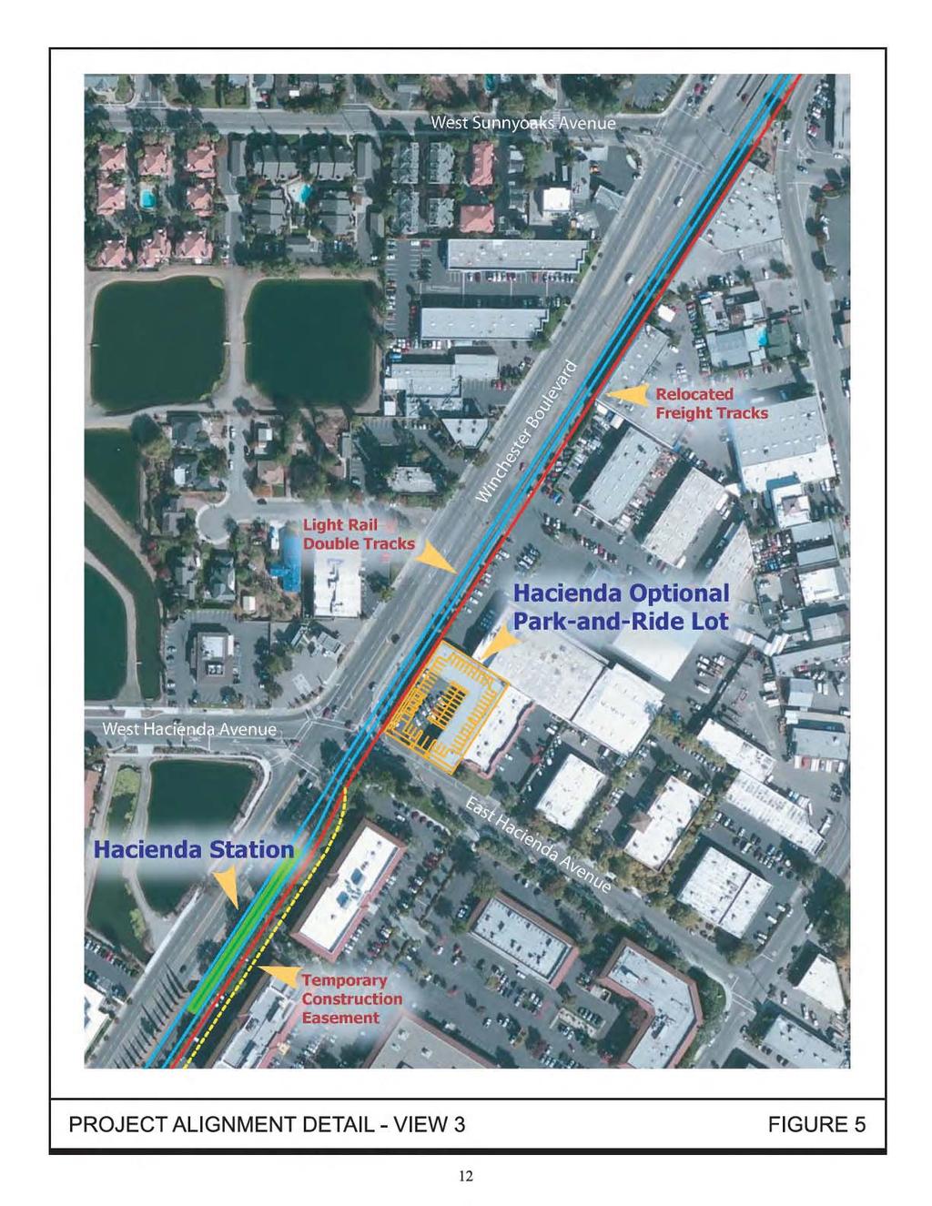
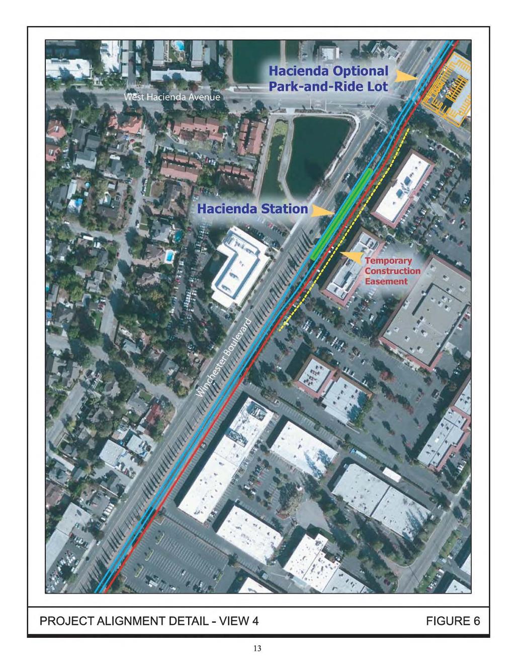
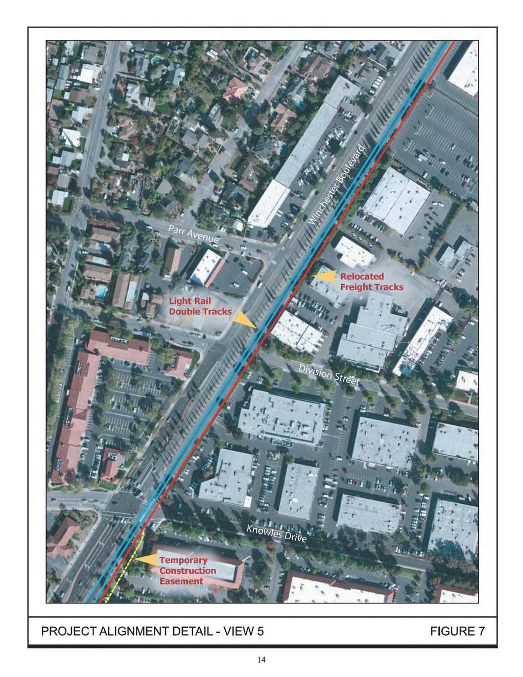
26 Chapter 2.0 Proposed Action This section gives an overview of the approved Vasona Corridor LRT Project and discusses the proposed design changes to the approved project that are the subject of this SEIR/EA. 2.1 OVERVIEW OF APPROVED PROJECT FTA and VTA previously prepared an EIS/EIR for the Vasona Corridor LRT project. The project was approved by VTA in May 2000 and by the FTA in June The approved project was the extension of the existing LRT system in Santa Clara County into what is commonly known as the Vasona Corridor. As shown on Figure 1, the 6.8-mile Vasona Corridor was proposed to extend from downtown San José through the City of Campbell to the Town of Los Gatos with nine new stations and four parkand-ride lots. The northern endpoint of the Vasona Corridor was proposed as a connection to the existing Children s Discovery Museum Station located near the San Carlos Street/Woz Way intersection. The southern endpoint was proposed as the Vasona Junction Station on Winchester Boulevard just north of SR 85. Construction of the Vasona Corridor project began in February 2001 and passenger service began in October To date, 5.2 miles of the 6.8-mile Vasona Corridor has been constructed. Currently, the Vasona Corridor extension goes from the Children s Discovery Museum Station near the San Carlos Street/Woz Way intersection in downtown San José south to the San Fernando, Diridon, Race Street, Fruitdale, Bascom (park-and-ride), Hamilton, and Downtown Campbell Stations, and terminates at the Winchester Station (park-and-ride) in Campbell. The final two stations, Hacienda and Vasona Junction, and construction of the line south of the Winchester Station into Los Gatos were never completed. 2.2 PROPOSED CHANGES TO THE APPROVED PROJECT The proposed Vasona Corridor LRT Extension Project would complete the originally planned Vasona Corridor with a 1.6-mile extension of the Vasona LRT. The extension would begin at the existing Winchester Station in Campbell and continue within the VTA right-of-way (ROW) to the Town of Los Gatos (see Figure 2). A number of design changes to the approved project are now proposed. The project would include constructing a double set of LRT tracks, increasing parking capacity and adding pedestrian access at the Winchester Station, constructing a new Hacienda Station with an optional park-and-ride lot, constructing a new Vasona Junction Station/park-and-ride lot and end-of-the-line facilities, and lengthening six existing station platforms along the Vasona Corridor alignment. Design changes to the originally proposed project are described in detail below. The proposed changes are graphically illustrated on Figures 3-8. Vasona Corridor Light Rail Transit Extension 7 Draft SEIR/EA Santa Clara County, California November 2012
27
28
29
30
31
32
33
34
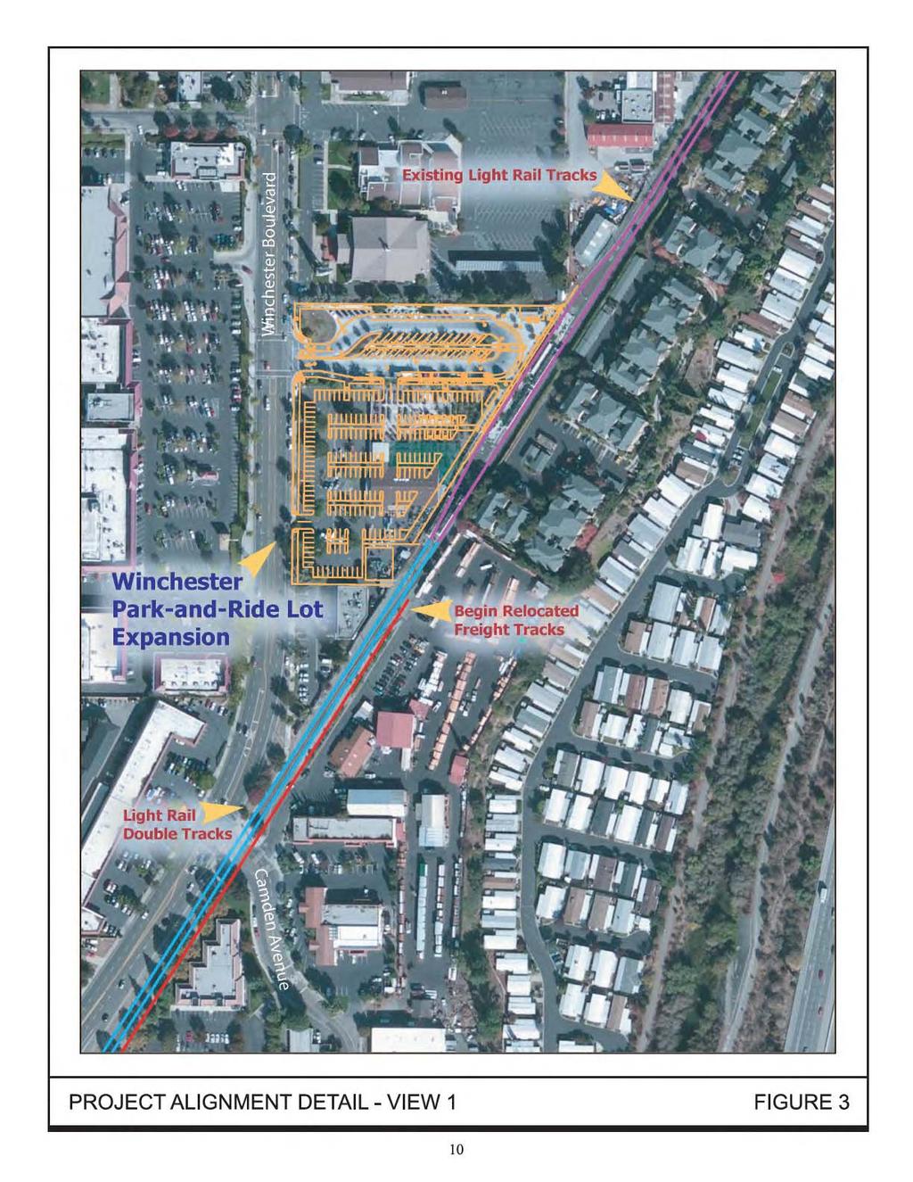
35 The Vasona Corridor LRT Extension Project would be implemented in two phases based on funding and projected ridership. Phase 1 would include all project features listed above except the Hacienda Station and optional Hacienda park-and-ride lot. The Hacienda Station (with or without the park-and-ride lot) would be constructed in Phase 2, contingent on sufficient funding and ridership. Throughout the remainder of the report, construction of the Hacienda Station without the optional park-and-ride lot will be referred to as Phase 2A and construction of the Hacienda Station with the optional parkand-ride lot will be referred to as Phase 2B. For the purposes of this analysis, it is assumed that Phase 1 would be completed in 2015 and Phase 2 would be completed in Design Change 1 Vasona Corridor LRT Extension The Vasona Corridor was originally proposed as a single set of tracks running parallel to Winchester Boulevard on the east side of the roadway and west of the freight tracks. With the original design, the freight tracks would not need to be relocated. The project proposes double LRT tracks for the remaining 1.6-mile extension. Installing double tracks would require that the freight tracks be relocated east of the new LRT tracks within the existing ROW Design Change 2 Winchester Station As discussed in Section 2.1, the Winchester Station was originally proposed with 123 to 170 parking spaces, which would have required the acquisition of the Summer Winds Nursery (formerly Woolworth Garden Center) and several other businesses. A Reevaluation/Addendum was approved in 2003 that reduced the total number of parking spaces to 54. As a result, the acquisition of the Summer Winds Nursery property was not required. The existing Winchester Station includes a 54-space parking lot. The parking is located in the middle of the lot (33 spaces) and along the northern boundary (21 spaces). A bus transit center that can accommodate four standard VTA buses (40 feet in length) or six VTA community buses (28 feet in length) is located along the southern boundary. The project proposes to acquire the Summer Winds Nursery property to the south of the existing parking lot and expand the available surface parking to 201 spaces (see Figure 9). Of the 201 proposed spaces, 31 would be in the existing parking lot (in the middle section) and the remaining 170 would be in the new lot. The 21 parking spaces along the northern boundary would be removed to allow for expansion of the bus transit center. The expanded bus transit center would accommodate 7 standard VTA buses or 10 VTA community buses. Bus and automobile access to the transit center and parking lot would be from Winchester Boulevard at the existing signalized intersection. Automobile access would also be provided via a new right-in/right-out only driveway south of the intersection. Vasona Corridor Light Rail Transit Extension 16 Draft SEIR/EA Santa Clara County, California November 2012
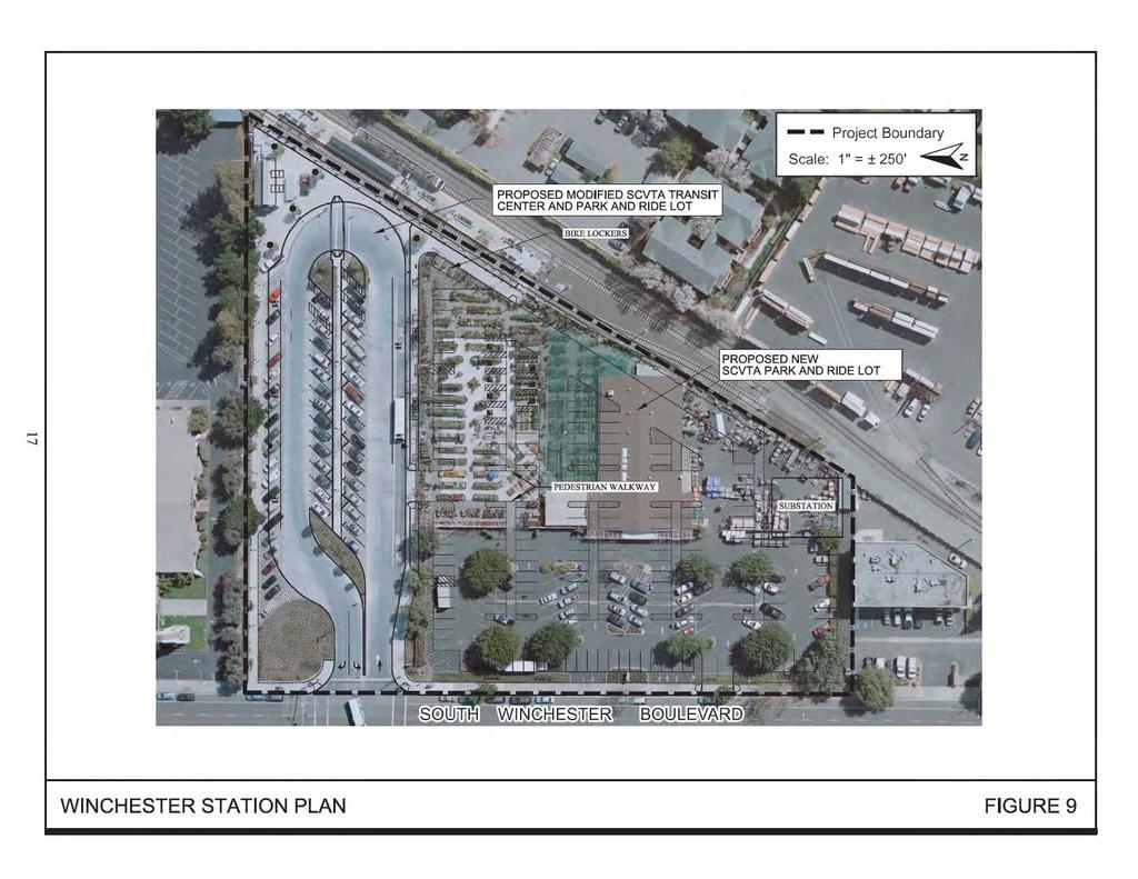
36
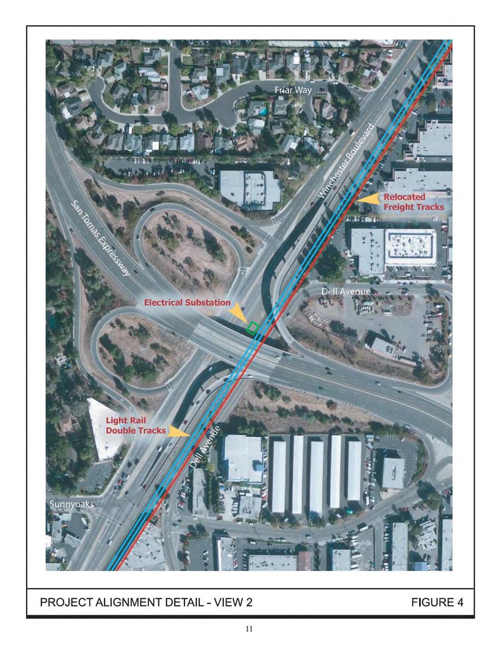
37 With the extension, the Winchester Station would no longer be the end-of-the-line station and the tracks south of the station would no longer serve as tail tracks 1. To provide power for the LRT, the project would also include an electrical power substation at the southeast corner of the new parking lot. An at-grade pedestrian crossing would be constructed east of the station to provide access to the station platform from the adjacent Avalon Campbell Apartments Design Change 3 Hacienda Station The Hacienda Station was originally proposed on Winchester Boulevard just south of Hacienda Avenue in Campbell. No parking for this station was included in the original project. An electric power substation was proposed immediately south of the station platform. The tracks were, however, never extended beyond the Winchester Station and the Hacienda Station was never constructed. The project proposes to construct the Hacienda Station in the same location that was identified in the original project. The station and relocation of the freight tracks would require the acquisition of ROW along the western property line of the Vasona Technology Park site. Approximately 80 existing parking spaces would be removed as a result. The area between the new property line and the building would be designated as a one-way drive aisle and restriped to accommodate approximately 35 parking spaces. Therefore, the ROW acquisition would result in a net loss of approximately 45 parking spaces. An optional park-and-ride lot would be located at the northeast corner of Winchester Boulevard and Hacienda Avenue with access from Hacienda Avenue. The surface lot would have 57 parking spaces (see Figure 10). The inclusion of the park-and-ride lot would require acquisition of a portion of a commercial property (APN ) that is currently occupied by an automotive repair center. The automotive repair center can house up to eight individual businesses. All businesses in the automotive repair center would be displaced. This station would require the elimination of the center left turn lane and restriping of the traffic lanes on Winchester Boulevard to accommodate through traffic from Chapman Drive to the beginning of the left turn lane to Hacienda Avenue. Elimination of the center left turn lane would preclude northbound traffic from directly accessing two driveways on the west side of Winchester Boulevard. Drivers needing to make a left turn into the two affected driveways would need to make a u-turn at Hacienda Avenue. The originally proposed electrical substation is not included as part of the station design; the substation is now proposed to be located at the Winchester Station. 1 A tail track is a small segment of track that is used to park trains. Vasona Corridor Light Rail Transit Extension 18 Draft SEIR/EA Santa Clara County, California November 2012
38
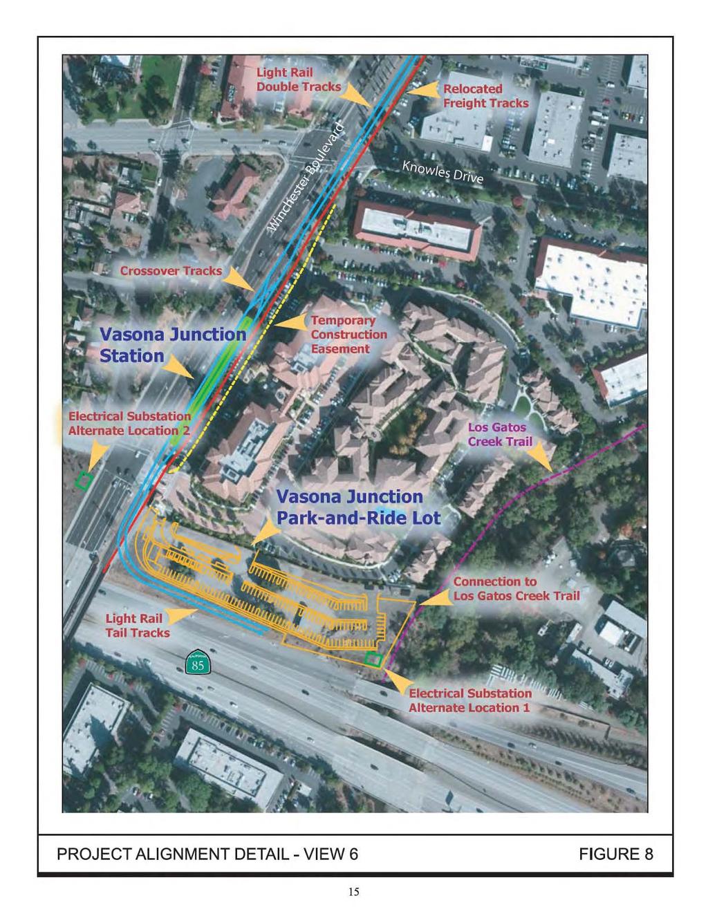
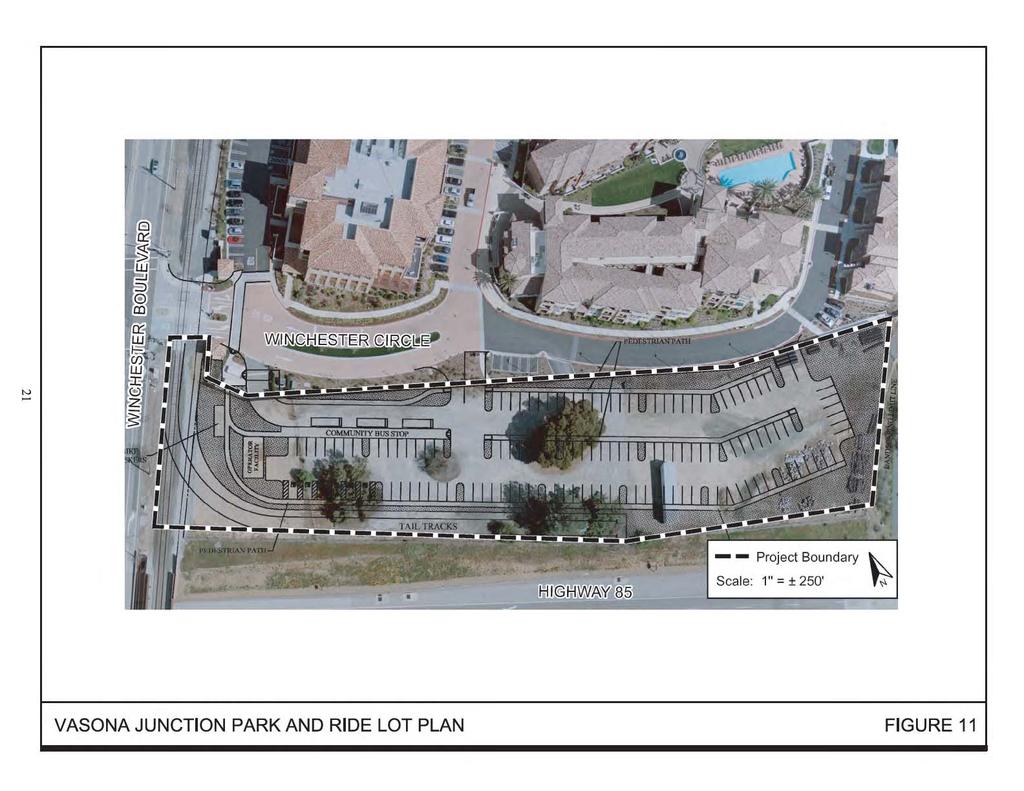
39 There are currently two bus stops in the vicinity of the proposed Hacienda Station. One bus stop is on the north side of Hacienda Avenue approximately 185 feet west of the Hacienda/Winchester intersection. The second stop is on the east side of Winchester Blvd., approximately 115 feet north of the Hacienda/Winchester intersection. These bus stops may be relocated to better interface with the light rail service Design Change 4 Vasona Junction Station The Vasona Junction Station was originally proposed on the east side of Winchester Boulevard just north of the SR 85 on-ramp. A park-and-ride lot ranging from 163 to 220 parking spaces was proposed immediately east of the station requiring acquisition of the former A to Z Nursery site (currently occupied by Netflix and the Aventino apartment community). No electrical substation was proposed for this station. The tracks were never extended beyond the Winchester Station and the Vasona Junction Station was never constructed. The project proposes to construct the Vasona Junction Station in the same location that was identified in the Final EIS/EIR. The proposed station would require ROW from the Netflix site resulting in the loss of up to 48 employee parking spaces. The project would move the park-and-ride lot to an undeveloped parcel located between the Netflix/Aventino site and SR 85, which is currently owned by the Santa Clara Valley Water District (SCVWD) (see Figure 11). The park-and-ride lot would also encroach on property owned by Caltrans. The new parking lot would have 135 parking spaces. A bus transit center would be located within the parking lot. Automobile and bus access to this parking lot would be from three driveways on Winchester Circle, the interior roadway through the Netflix/Aventino site. The first driveway, immediately east of the railroad crossing, would provide one-way access into the parking lot for buses. The two remaining driveways would be for automobiles. The center driveway would also be used as an exit for buses. This station area would include end-of-the-line facilities consisting of tail tracks (to provide sufficient storage to meet LRT system operational needs), which would terminate along the south side of the park-and-ride lot, and a light rail/bus operators break room facility The proposed project also includes an electrical substation and two new bus stops. The electrical substation would be located on the west side of Winchester Boulevard, immediately south of the SR 85 on-ramp or in the southeast corner of the park-and-ride lot. The bus stops would be located on the west side of Winchester Boulevard north of the SR 85 on-ramp and on the east side of Winchester Boulevard adjacent to the proposed LRT station. Pedestrian and bicycle access would be provided from the parkand-ride lot to the existing Los Gatos Creek Trail, which is located immediately east of the lot. Vasona Corridor Light Rail Transit Extension 20 Draft SEIR/EA Santa Clara County, California November 2012
40
41 2.2.5 Design Change 5 Existing Station Platform Extensions Six of the eight existing LRT station platforms along the Vasona Corridor are sized between 180 and 200 feet long. At this length, the stations can accommodate one- and two-car trains. The project proposes to extend the platforms at the Winchester, Campbell, Hamilton, Bascom, Fruitdale, and Race Street Stations to 280 feet to accommodate three-car trains. This change would make these stations consistent with the rest of the VTA LRT system. The two remaining stations on the Vasona Corridor, San José Diridon and San Fernando, are already sized to accommodate three-car trains Required Right-Of-Way Acquisitions Implementation of the proposed design changes will require ROW take or easements on a number of parcels. Full acquisitions are anticipated at two locations, namely for the expansion of the Winchester park-and-ride lot and for the new Vasona Junction park-and-ride lot. Partial acquisitions are anticipated at 3-4 locations and easements will be needed at 5-6 locations. The affected parcels are outlined in Table 1 below. TABLE 1 Right-Of-Way Acquisitions APN Number Address/Parcel Location Property Owner Required Take SR 85 ROW Caltrans Permanent easement for electrical substation (if this alternate location is chosen) Not Applicable SR 85 ROW Caltrans Partial acquisition or permanent easement for light rail tail tracks Winchester Blvd, Los Gatos Vacant Parcels Santa Clara Valley Water District Full acquisition for Vasona Junction park-and-ride lot Common area around & Winchester Circle, Los Gatos Si 32 LLC Partial acquisition for Vasona Junction Station, temporary construction easement, ingress/egress easement on Winchester Circle Not Applicable A Street Town of Los Gatos Encroachment Permit Partial acquisition for E. Hacienda Avenue Hacienda Station, temporary Hines Vaf No. Cal construction easement, Properties LP SCVWD easement for Page Distribution System Winchester Boulevard Cloud, Stephen R, Trustee Et Al Not Applicable San Tomas Expressway ROW Santa Clara County Winchester Boulevard Railway Avenue Campbell Nurseries, LLC Bay Apartment Communities, Inc. Partial acquisition for Hacienda Station park-andride lot (optional) Permanent easement for electrical substation Full acquisition for Winchester Station park-andride lot expansion Pedestrian Access Easement Vasona Corridor Light Rail Transit Extension 22 Draft SEIR/EA Santa Clara County, California November 2012
42 2.2.7 Updated LRT Ridership Projections The original EIS/EIR contained ridership projections based on the Association of Bay Area Governments (ABAG) 1998 land use forecasts. As part of the preparation of this SEIR/EA, ridership projections were updated to reflect existing conditions, as well as current land use forecasting data through the year Table 2 compares the LRT ridership (expressed as daily boardings) under various scenarios for each of the three stations that are within the project segment. TABLE 2 Existing and Projected Daily Boardings Timeframe/Scenario Winchester Hacienda Vasona Junction Total Boardings Existing 1, ,007 Year 2015 No Project 1, ,245 Year 2015 With Phase 1 Project ,675 Year 2035 No Project 2, ,144 Year 2035 With Phase 1 Project 1, , Year 2035 With Phase 1 and Phase 2A Project 1, ,758 Year 2035 With Phase 1 and Phase 2B Project 1, ,861 Source: Santa Clara Valley Transportation Authority The data in Table 2 shows that LRT ridership will increase with the proposed extension to Vasona Junction. The data also shows that the extension to Vasona Junction will result in a decrease in the number of daily boardings at the Winchester Station in 2015 and The decrease is not unexpected as some riders who live or work close to the Hacienda or Vasona Junction Station sites, and who currently use the Winchester Station, will use the new stations once they are constructed. 2.3 CONSTRUCTION STAGING AREAS The locations (footprints) of all permanent facilities would be used as construction staging areas, as each of these locations would involve some degree of construction equipment usage and storage, construction vehicle parking, and materials storage. These permanent facility locations would include the VTA railroad ROW, station areas, park-and-ride lots, electric power substations, and bus stops. Temporary construction easements would be required along the east side of the railroad corridor at the Vasona Junction Station in Phase 1 of the project and Hacienda Station in Phase 2 of the project. These areas would be located in existing parking lots or landscaped areas. No building structures would be impacted. Please see Table 1 for the list of parcels from which construction easements are anticipated to be needed. Vasona Corridor Light Rail Transit Extension 23 Draft SEIR/EA Santa Clara County, California November 2012
43 Chapter 3.0 Consistency with Adopted Plans and Policies In conformance with Section 15125(d) of the CEQA Guidelines, the following section discusses the consistency of the proposed project with relevant plans and policies that were adopted or revised since adoption of the Vasona Corridor Light Rail Transit Project Final EIS/EIR. 3.1 CALIFORNIA SENATE BILL SB 375 REDESIGNING COMMUNITIES TO REDUCE GREENHOUSE GASES Under the requirements of Senate Bill (SB) 375, the Metropolitan Transportation Commission (MTC) in partnership with the ABAG will develop a Sustainable Community Strategy to achieve the Bay Area s regional greenhouse gas reduction target, a process expected to continue through early The targets for MTC in the San Francisco Bay Area adopted in September 2010 by the California Air Resources Board (CARB) include a 7 percent reduction in greenhouse gases per capita from passenger vehicles by 2020 compared to emissions in The adopted target for 2035 is a 15 percent reduction per capita from passenger vehicles when compared to emissions in MTC anticipates that the adopted targets may be achieved through a more focused growth strategy and greater reliance on road pricing (i.e., toll lanes) and other strategies. The proposed project involves expanding the existing public transportation network, which will reduce individually owned passenger vehicle travel within the region, consistent with the basic goals of SB STATE CLIMATE CHANGE STRATEGIES AND POLICIES California s multi-agency Climate Action Team has identified a range of strategies to reduce greenhouse gas emissions and the CARB, under Assembly Bill (AB) 32, approved the Climate Change Scoping Plan in The CARB and other State agencies are currently working on regulations and other initiatives to implement the Scoping Plan, which outlines measures to achieve statewide greenhouse gas emissions in 2020 that are equivalent to 1990 emissions. While the Scoping Plan focuses on measures and regulations undertaken at a statewide level, implementation of measures at the local level are also important. The Scoping Plan recognizes the importance of local and regional government leadership in ensuring that California s land use and transportation planning processes are designed to be consistent with efforts to achieve a clean energy future. Measures identified in the Scoping Plan include the inclusion of transportation fuels in the cap-and-trade program, a Low Carbon Fuel Standard to reduce the carbon intensity of transportation fuels, enforcement of regulations that reduce greenhouse gas emissions from vehicles, and policies to reduce transportation Vasona Corridor Light Rail Transit Extension 24 Draft SEIR/EA Santa Clara County, California November 2012
44 emissions by changes in future land use patterns and community design as well as improvements in public transportation. 2 Measure 6 in the Scoping Plan (Regional Transportation-Related Greenhouse Gas Targets) will be implemented as a part of regional planning efforts under SB 375 to reduce greenhouse gas emissions from changed land use patterns and improved transportation. While planning under the SB 375 process has not been completed, extension of public transportation as part of a planned transportation system to reduce GHG emissions would be generally consistent with the purposes of this measure. 3.3 BAY AREA 2010 CLEAN AIR PLAN The Bay Area Air Quality Management District (BAAQMD), in cooperation with MTC and ABAG, prepared the Bay Area 2005 Ozone Strategy (Ozone Strategy). The Ozone Strategy served as a roadmap showing how the San Francisco Bay Area would achieve compliance with the State one-hour air quality standard for ozone as expeditiously as practicable and how the region would reduce transport of ozone and ozone precursors to neighboring air basins. In 2010, BAAQMD adopted the Bay Area 2010 Clean Air Plan (CAP), which updated the 2005 Ozone Strategy to comply with State air quality planning requirements as codified in the California Health and Safety Code. The CAP provides a comprehensive plan to improve Bay Area air quality and protect public health. The CAP defines a control strategy that BAAQMD and its partners will implement to: (1) reduce emissions and decrease ambient concentrations of harmful pollutants; (2) safeguard public health by reducing exposure to air pollutants that pose the greatest health risk, with an emphasis on protecting the communities most heavily impacted by air pollution; and (3) reduce greenhouse gas (GHG) emissions to protect the climate. The proposed project would extend the existing Vasona Corridor LRT line and allow longer trains along the corridor, thereby increasing the accessibility and capacity of the LRT system for current and future riders. By adding capacity and improving accessibility to the LRT system, regional traffic volumes will decrease. As discussed in Sections 4.9 and 4.11, implementation of the proposed project will result in a net decrease in regional air pollutants and GHG emissions. The proposed project would aid in the implementation of the 2010 CAP and is, therefore, consistent with the CAP. 3.4 VALLEY TRANSPORTATION PLAN 2035 VTA s Valley Transportation Plan 2035 (VTP 2035) identifies the programs, projects and policies VTA s Board of Directors would like to pursue over the lifetime of the plan. It connects projects with anticipated funds and lays out a framework for the development and maintenance of VTA s transportation system over the next 25 years. It considers all 2 California Air Resources Board. Climate Change Scoping Plan. December Vasona Corridor Light Rail Transit Extension 25 Draft SEIR/EA Santa Clara County, California November 2012
45 travel modes and addresses the links between transportation and land use planning, air quality, energy use, and community livability. Completion of the Vasona Corridor LRT to Vasona Junction is an identified project in VTP As a result, implementation of the proposed project is consistent with the plan. 3.5 CITY OF CAMPBELL GENERAL PLAN The project is conformance with the goals and policies of the City of Campbell s Circulation Element. Specifically, the General Plan states that the City should plan for the regional transportation needs of the community by supporting the efforts of the VTA and the completion of the entire Vasona Corridor Light Rail Line. 3.6 TOWN OF LOS GATOS GENERAL PLAN The project is consistent with the goals and policies contained in the Town of Los Gatos Vasona Light Rail Element of the General Plan. Specifically, the General Plan states that the Town should promote the construction of the Vasona Corridor Light Rail Line and mass transit facilities. Vasona Corridor Light Rail Transit Extension 26 Draft SEIR/EA Santa Clara County, California November 2012
46 Chapter 4.0 Environmental Setting, Impacts, & Mitigation INTRODUCTION The Council of Environmental Quality (CEQ) regulations for implementing NEPA (40 CFR Section ) specify that the analysis of effects under NEPA requires consideration of both context and intensity of the action. Context refers to analysis of several different contexts, as appropriate, such as the affected region, locality, and site specific area including both short- and long-term effects. Intensity refers to the severity of impact, which includes consideration of beneficial and adverse impacts, unique characteristics and/or resources, degree to which the action may adversely affect human health or the environment, degree to which the effects are uncertain and/or likely to be controversial, whether it is anticipated that the action may contribute to a cumulatively significant impact on the environment, and/or threatens a violation of environmental protection laws. Since this is a joint NEPA and CEQA document, each section in this chapter concludes with both a NEPA finding and a CEQA determination. When discussing NEPA findings, the terminology used in this analysis includes no adverse effect and adverse effect. When discussing CEQA determinations, the terminology used in this analysis includes no impact, less than significant impact, and significant impact. 4.1 LAND USE The following information is based in part on a parking survey prepared by Hexagon Transportation Consultants in April 2012 (see Appendix A) Existing Setting The Vasona Corridor passes by a variety of land uses including residential, commercial, industrial, open space, and public facilities. Land uses along the Vasona Corridor have not changed substantially since adoption of the Vasona Corridor Light Rail Transit Project Final EIS/EIR. The discussion below highlights the changes in land uses at the existing stations, the proposed Hacienda and Vasona Junction Station locations, and along the corridor from Winchester Station to Vasona Junction Station, where applicable. At the time of the original analysis, the Race Street Station was surrounded by industrial and commercial land uses. Since completion of the Race Street Station, the office buildings immediately east of the station were demolished and a four-story multi-family condominium complex was constructed. No other land uses changes have occurred along the completed Vasona Corridor alignment. Vasona Corridor Light Rail Transit Extension 27 Draft SEIR/EA Santa Clara County, California November 2012
47 The originally proposed location of the Vasona Junction Station park-and-ride lot was occupied by A to Z Nursery. Immediately north of the nursery site was a light industrial office complex. Since adoption of the Vasona Corridor Light Rail Transit Project Final EIS/EIR, the industrial complex and nursery have been demolished and a new office building (occupied by Netflix) and apartment complex (Aventino) have been constructed. The office building fronts Winchester Boulevard and the apartment complex is located behind the office building, adjacent to Los Gatos Creek. Because the originally proposed location of the park-and-ride has been redeveloped, the parkand-ride lot is now proposed on the adjacent property (owned by SCVWD and Caltrans) immediately south of the new development (see Figure 12). The proposed Vasona Junction Station platform would be a center platform located between two LRT tracks in front of the office building. The western end of the Netflix site, which is directly adjacent to the existing VTA ROW, contains surface parking. The parking spaces adjacent to the ROW would be acquired by VTA as part of the proposed project to allow relocation of the existing freight tracks to make space for the Vasona Junction Station platform and the double set of LRT tracks. No substantial land use changes have occurred around the proposed Hacienda Station and optional park-and-ride lot locations (see Figure 13), the Winchester Station and park-and-ride lot (see Figure 14), or the railroad corridor between Winchester Station and the Vasona Junction Station site. The Hacienda Station would be located adjacent to the Vasona Technology Park, which contains surface parking. The western end of the Vasona Technology Park site, which is directly adjacent to the existing VTA ROW, contains surface parking. The parking spaces adjacent to the ROW would be acquired by VTA as part of the proposed project to allow relocation of the existing freight tracks to make space for the Hacienda Station platform and the double set of LRT tracks. The Economy Lumber Company is currently located at the northeast corner of Winchester Boulevard and Camden Avenue, just south of the Winchester Station. An existing single freight track runs parallel to the western property line of the Economy Lumber site. The entrance to this business is located on Camden Avenue, in close proximity to the freight track and Winchester Boulevard. At some point in the past, this entrance was widened by Economy Lumber to facilitate automobile and truck traffic entering and exiting the business. The widened entrance, however, illegally encroaches into the existing VTA ROW. In order to extend the Vasona LRT Line to serve the Town of Los Gatos, which would require installation of two new LRT tracks and relocation of the freight track, this encroachment would have to be removed. When VTA prepares to construct the LRT line, appropriate steps must be taken to remove this encroachment, which would narrow the entrance to Economy Lumber. 3 Any effect on traffic circulation that might result from this narrowing, however, would not constitute an impact of the project since the existing condition represents an illegal encroachment. 3 This encroachment could also be required to be removed by order of the Union Pacific Railroad or the California Public Utilities Commission prior to construction of the Vasona LRT Extension. Vasona Corridor Light Rail Transit Extension 28 Draft SEIR/EA Santa Clara County, California November 2012
48
49
50
51 4.1.2 CEQA Thresholds of Significance For the purposes of this SEIR, a land use impact is considered significant if the project would: physically divide an established community; conflict with any applicable land use plan, policy, or regulation of an agency with jurisdiction over the project (including, but not limited to the general plan, specific plan, local coastal program, or zoning ordinance) adopted for the purpose of avoiding or mitigating an environmental effect; or conflict with any applicable habitat conservation plan or natural community conservation plan Land Use Impacts Land Use Compatibility Since adoption of the Vasona Corridor Light Rail Transit Project Final EIS/EIR, two major land use changes have occurred. A new condominium complex was constructed adjacent to the Race Street Station and an office building and apartment complex were constructed on the originally proposed site for the Vasona Junction Station park-andride lot. As is evident throughout the existing LRT system, housing and office buildings are compatible with LRT rail lines and associated land uses (i.e., rail stations) so long as acceptable noise levels can be maintained. The new housing adjacent to the Race Street Station was constructed after the station was complete. As a result, the building was designed and constructed with various sound attenuation features (e.g., acoustically-rated doors and windows, insulation, etc.) to address any noise issues associated with the existing station and rail line. The new office building and apartment complex adjacent to the proposed Vasona Junction Station and park-and-ride lot currently experience exterior ambient noise levels of approximately 65 dba. As discussed in Section 4.12, Noise & Vibration, implementation of the proposed project would increase exterior noise levels by approximately one decibel, which is not a significant change. Since all previously identified noise impacts were mitigated to a less than significant level and noise from existing and future LRT operations would not substantially impact the new land uses, the proposed project is compatible with all surrounding land uses. (Less Than Significant Impact per CEQA; No Adverse Effect per NEPA) Impacts to the Community The proposed rail alignment is within the existing VTA ROW that currently has an existing operational freight line that does not physically divide an established neighborhood community. Implementation of the proposed project would not result in the relocation or modification of the existing ROW. The project would relocate the freight line to the east allow for the installation of the LRT double tracks. This minor modification of the existing rail alignment would not physically divide an established neighborhood community. (No Impact per CEQA; No Effect per NEPA) Vasona Corridor Light Rail Transit Extension 32 Draft SEIR/EA Santa Clara County, California November 2012
52 Impacts to Businesses and Residences The proposed project would result in direct impacts to land uses in the City of Campbell. If the optional park-and-ride lot were to be constructed at the Hacienda Station, it would require acquisition and demolition of an automotive center that can house up to eight individual businesses, six of which are currently occupied. The Summer Winds Nursery adjacent to the existing Winchester Station park-and-ride lot would also be acquired and demolished to allow for expansion of the park-and-ride lot and construction of an electrical substation. The 1999 Vasona Corridor Light Rail Transit Project Final EIS/EIR assumed acquisition and demolition of this business because the park-and-ride was originally designed to be much larger. The affected properties would be purchased at fair market value and VTA s Relocation Program would be implemented. The Relocation Program, which complies with State and Federal relocation requirements (i.e., Uniform Relocation Assistance and Real Property Acquisition Policies Act of 1970, as amended, and the California Government Code, Chapter 16, Section et seq.), provides assistance to affected business owners. The assistance, which varies on a case-by-case basis, can be both financial (e.g., moving costs, rent subsidies, relocation costs, personal property losses, reestablishment expenses, etc.) and technical (e.g., providing information regarding suitable replacement sites, providing referrals, assisting with lease negotiations, assisting with moving logistics, etc.). Business owners also have the option of receiving a fixed payment in lieu of relocating. (Less Than Significant Impact per CEQA; No Adverse Effect per NEPA) Impacts to Existing Infrastructure The SCVWD has identified two facilities, the Page Distribution System and the Rinconada Force Main, which could be impacted by the construction and operation of the Project. VTA staff met with SCVWD staff on March 10, 2010 and September 19, 2011 to discuss the potential impacts, as well as measures to avoid any significant effects on these facilities. Page Distribution System The Page Distribution System diverts water from Los Gatos Creek to help fill the groundwater recharge ponds in Campbell, including the Page Ponds. The system terminates at Smith Creek in Campbell. Portions of the system are open channel and other sections are contained within a culvert and pipeline. The system crosses under the LRT alignment in a culvert near the proposed Hacienda Station and extends partially into the Vasona Technology Park parking lot in a pipeline before turning south. Implementation of the proposed project would require lengthening the culvert under the LRT tracks. A minor realignment of the pipeline under the Vasona Technology Park parking lot would also be required to accommodate the relocation of the existing freight tracks. Construction of the culvert and relocation of the pipeline would require that either the system be taken off-line or the water be diverted around the work area. Vasona Corridor Light Rail Transit Extension 33 Draft SEIR/EA Santa Clara County, California November 2012
53 Based on information provided by the SCVWD, the best time to take the system off-line is during the months of January to March when impacts to the SCVWD s operations would be minimized. In either case, VTA would coordinate the work with the SCVWD. Realignment of the pipeline under the Vasona Technology Park would require a utility easement for the SCVWD, as shown Table 1. Rinconada Force Main The Rinconada Force Main, which is a major water supply underground pipeline, traverses the site of the proposed Vasona Junction park-and-ride lot. Two vaults that provide access to the pipeline are also present on the site. Construction of the park-and-ride facility will not require the relocation of this pipeline. The SCVWD has, however, expressed concern that the project might result in damage to the pipeline during construction and/or from the vibration effects of vehicles driving over the pipeline at various locations. VTA has committed to implementing measures to avoid such impacts, including the following: Construction methodology would include either building up the parking area to provide greater clearance to the pipeline or constructing a cap over the pipeline. The building up option would require inches of excavation to stabilize the base prior to building up the parking lot. The two vaults would be located within station landscape areas and would remain accessible to SCVWD staff. The pipeline is currently encased under the freight railroad track. VTA would extend this encasement below the LRT tracks. VTA would also install tire-derived aggregates to provide vibration attenuation. The proposed project has been designed to avoid conflicts with existing SCVWD facilities that are necessary for water supply management and distribution. Therefore, the proposed project would have a less than significant impact on SCVWD facilities. (Less Than Significant Impact per CEQA; No Adverse Effect per NEPA) Mitigation and Avoidance Measures for Land Use Impacts No mitigation is required or proposed Conclusion The proposed project would be compatible with all adjacent and nearby land uses, would not divide an established community, and would not significantly impact any local businesses or housing. Implementation of the proposed project would not result in any new land use impacts or impacts of greater severity than were identified in the Vasona Corridor Light Rail Transit Project Final EIS/EIR. (Less Than Significant Impact per CEQA; No Adverse Effect per NEPA) Vasona Corridor Light Rail Transit Extension 34 Draft SEIR/EA Santa Clara County, California November 2012
54 4.2 AESTHETICS/VISUAL The project alignment is surrounded by development typical of an urban setting including residences, businesses, open space, roadways, etc. Land uses along the Vasona Corridor have not changed substantially since adoption of the Vasona Corridor Light Rail Transit Project Final EIS/EIR and, as a result, the visual setting of the corridor has not changed substantially either. The discussion below highlights the visual changes at the existing stations, the proposed Hacienda and Vasona Junction Station locations, and along the corridor from Winchester Station to Vasona Junction Station Regulatory Setting NEPA establishes that the federal government use all practicable means to ensure all Americans safe, healthful, productive, and aesthetically and culturally pleasing surroundings (42 U.S.C. 4331[b][2]). Likewise, CEQA establishes that it is the policy of the state to take all action necessary to provide the people of the state "with enjoyment of aesthetic, natural, scenic and historic environmental qualities." (CA Public Resources Code Section 21001[b]) Existing Setting Completed Vasona Corridor At the time of the original analysis, the Race Street Station location was surrounded by low-rise industrial and commercial land uses. Immediately east of the station were two two-story office buildings. The buildings were constructed of concrete and glass, typical of 1980s era industrial buildings in San José, and surrounded by surface parking lots and landscape trees. Since completion of the Race Street Station, the two office buildings were demolished and a large five-story multi-family condominium complex was constructed. The buildings in the complex have minimal setbacks to the adjacent streets and limited surface parking. Open space on-site is provided in an interior courtyard, which is not visible from off-site. While the massing of this development is much greater than the previous office buildings, the residential buildings do not substantially alter the visual character of the area around the Race Street Station. No other substantial visual changes have occurred along the completed Vasona Corridor alignment Winchester Station The existing Winchester Station is currently developed with a small park-and-ride lot with 54 parking spaces and a bus transit center. The parking area is accessed by a loop road. Vegetation at the Winchester Station site includes small trees dispersed throughout the park-and-ride lot and a small grassy area at the northwest corner of the site. The adjacent Summer Winds Nursery site is developed with a single-story commercial building set back from the roadway and a large asphalt surface parking lot with several Vasona Corridor Light Rail Transit Extension 35 Draft SEIR/EA Santa Clara County, California November 2012
55 large trees that fronts Winchester Boulevard. Other vegetation on the site includes city owned street trees and narrow grass strips along the north and west property lines (see Photo 1) LRT Line, Winchester Station to Hacienda Station The alignment between the existing Winchester Station and the proposed Hacienda Station would be 0.9 miles in length, and would be within the existing VTA railroad ROW corridor, which is currently developed with freight tracks. There are no trees in this portion of the extension. No substantial visual changes have occurred along this alignment since adoption of the Vasona Corridor Light Rail Transit Project Final EIS/EIR Hacienda Station and Optional Park-and-ride Lot The proposed Hacienda Station platform would be located on the east side of Winchester Boulevard just south of Hacienda Avenue in the City of Campbell. No substantial visual changes have occurred in the proposed station area since adoption of the Vasona Corridor Light Rail Transit Project Final EIS/EIR. North of the station location (at the northeast corner of Hacienda Avenue and Winchester Boulevard) is a parcel that is currently developed with a single-story L- shaped commercial building that currently contains six automotive repair businesses and can house up to eight businesses. This parcel has been identified as an optional park-and-ride lot site. The commercial building lines the northern and eastern boundaries of the parcel. A surface parking lot fronts both Winchester Boulevard and Hacienda Avenue. The automotive repair center is accessed from Hacienda Avenue and has street trees and landscaping along Winchester Boulevard (see Photo 2) LRT Line, Hacienda Station to Vasona Junction Station The alignment between the Hacienda Station and Vasona Junction Station would be approximately 0.7 miles in length, and would be within the existing VTA railroad ROW corridor, which is currently developed with freight tracks. The alignment is lined with a continuous row of small cypress trees from just south of Hacienda Avenue to Knowles Drive. South of Knowles Drive, the alignment is lined with small deciduous trees and a few large evergreen trees. No substantial visual changes have occurred along this alignment since adoption of the Vasona Corridor Light Rail Transit Project Final EIS/EIR Vasona Junction Station The originally proposed location of the Vasona Junction Station park-and-ride lot was occupied by a plant nursery. Immediately north of the nursery site was a light industrial office complex. Since adoption of the Vasona Corridor Light Rail Transit Project Final EIS/EIR, the industrial complex and nursery site have been demolished and a new four Vasona Corridor Light Rail Transit Extension 36 Draft SEIR/EA Santa Clara County, California November 2012
56
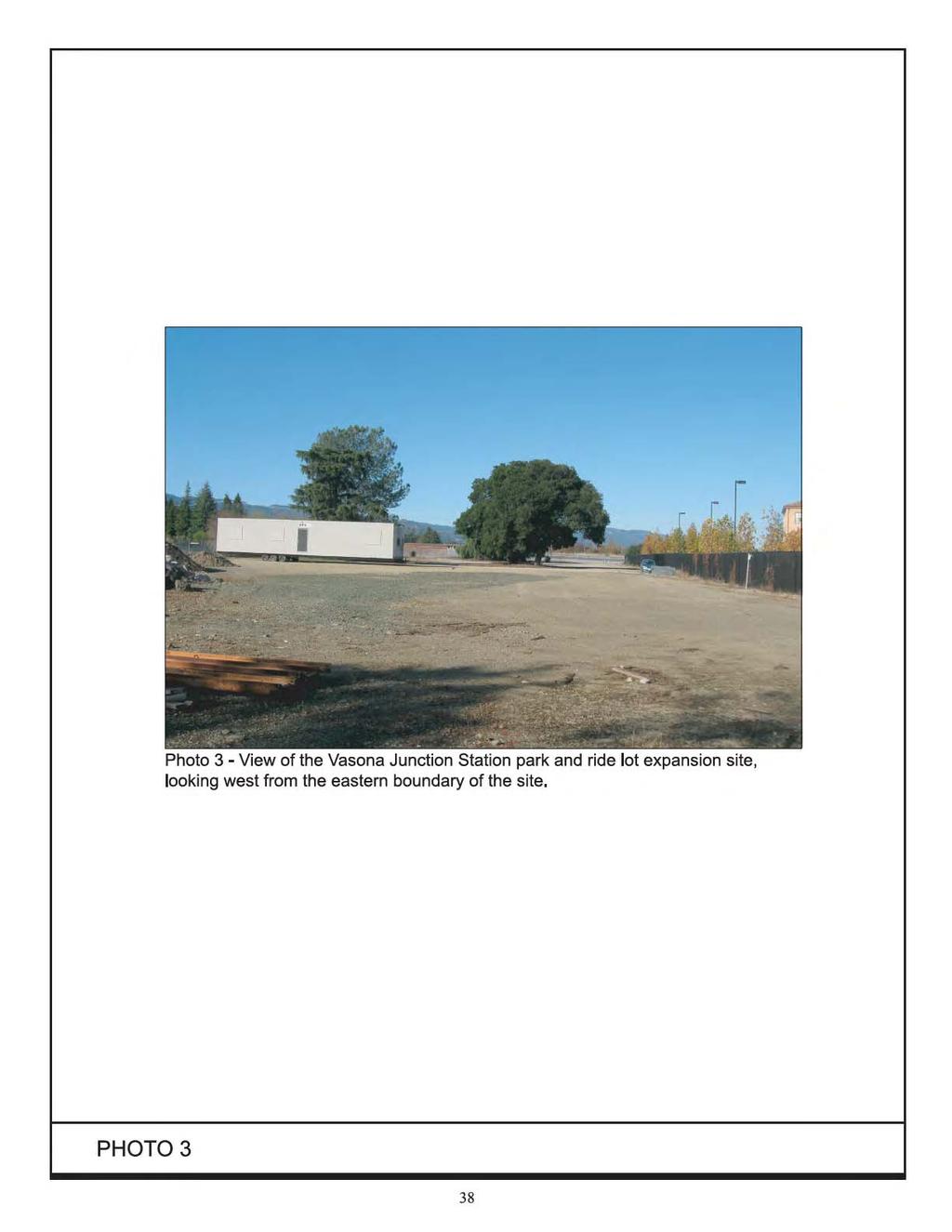
57
58 story office building (Netflix) and three-story apartment complex (Aventino) have been constructed. The office building and a small parking lot fronts Winchester Boulevard and the apartment complex is behind the office building, adjacent to the Los Gatos Creek corridor. Because the originally proposed location of the park-and-ride lot has been redeveloped, the park-and-ride lot is now proposed on the adjacent property immediately south of the new development. The proposed Vasona Junction Station platform would be a center platform located between the two proposed LRT tracks in front of the Netflix site. The Vasona Junction Station park-and-ride lot and end-of-the-line facilities would be located on two undeveloped parcels located between the existing Netflix/Aventino Apartments site and SR 85. The undeveloped parcels, which are owned by SCVWD, are currently surrounded by a six-foot chain link fence on the west, south, and east boundaries and an eight-foot chain link fence with privacy slats along the northern boundary. The parcels are currently being used by SCVWD to store materials (see Photo 3). Aside from the development of the new office building and apartment complex, no other substantial visual changes have occurred in the proposed station area since adoption of the Vasona Corridor Light Rail Transit Project Final EIS/EIR CEQA Thresholds of Significance For the purposes of this SEIR, visual/aesthetic impact is considered significant if the project would: have a substantial adverse effect on a scenic vista; substantially damage scenic resources, including, but not limited to, trees, rock outcroppings, and historic buildings within a state scenic highway; substantially degrade the existing visual character or quality of the site and its surroundings; or create a new source of substantial light or glare which would adversely affect day or nighttime views in the area Aesthetics/Visual Impacts Visual Changes to the Physical Environment Changes to the existing visual setting as a result of construction of the Vasona Corridor extension and the associated park-and-ride lots would include removal of one to two commercial buildings, 4 construction of station shelters and platforms, extension of existing platforms, relocation of existing freight tracks and placement of new LRT tracks, and the paving of up to four parcels for use as park-and-ride lots. Another visual feature of the project would be the overhead lines that supply electricity to run the LRT trains. 4 One building will be removed for expansion of the Winchester Station park-and-ride lot. A second building could be removed if the optional Hacienda park-and-ride lot were constructed. Vasona Corridor Light Rail Transit Extension 39 Draft SEIR/EA Santa Clara County, California November 2012
59 The visual effects resulting from the expansion of the Winchester park-and-ride lot were described in the original EIS/EIR. As noted in that document, the changes would be associated with the removal of a commercial nursery building (with its adjacent surface parking) and its replacement with a new surface parking lot. This would not be considered a substantial adverse change in the existing aesthetic/visual environment. The site and the adjacent properties are currently developed with commercial, residential, and institutional uses and the park-and-ride lot would be consistent with that setting. (Less Than Significant Impact per CEQA; No Adverse Effect per NEPA) In order to address the potential visual impact of the proposed stations along Winchester Boulevard, photo simulations were prepared based on standard station designs throughout the LRT system. Figure 15 shows the view points of the photos simulations. As shown on Figure 16, implementation of the Hacienda Station would result in the removal of up to five mature trees along Winchester Boulevard. The loss of these trees would alter the visual character of the area, but would not significantly degrade the neighborhood aesthetic within this urbanized area. This is consistent with the findings of the adopted Vasona Corridor Light Rail Transit Project Final EIS/EIR, which did not identify a visual impact from the Hacienda Station. Since adoption of the Vasona Corridor Light Rail Transit Project Final EIS/EIR, changes have been made to the project that would result in changes to the visual character of the project area that were not analyzed in the original EIS/EIR. The project now proposes an optional park-and-ride lot at Hacienda Station and construction of the Vasona Junction Station park-and-ride lot on a new site. The proposed site for the Hacienda Station park-and-ride lot is within an urban area of commercial and industrial land uses with large surface parking lots. Redevelopment of this site with a park-and-ride lot would result in the loss of some landscape trees, but would be visually consistent with the existing land uses. The automotive repair center does not significantly contribute to the visual character of the area and its removal would not impact the aesthetics of the area. Construction of the Vasona Junction Station would require the removal of up to 15 established trees of varying sizes and several newly planted trees currently located within the ROW in front of the Netflix building. As shown in Figure 17, the loss of these trees would alter the visual character of the area, but would not significantly degrade the neighborhood aesthetic within this urbanized area. Construction of the Vasona Junction Station park-and-ride lot would pave over a vacant lot located along the Los Gatos Creek Trail. The location of the proposed lot is immediately south of the originally proposed location which was also adjacent to the creek trail. The undeveloped lot is located in an area of concentrated urban development and is fenced off and used by SCVWD to store materials. While there are a few large trees on-site, including a native oak tree, the lot is not a contributing factor to the visual environment along the creek trail and development of the site as a parking lot with landscaping would not impact the aesthetics of the area. Vasona Corridor Light Rail Transit Extension 40 Draft SEIR/EA Santa Clara County, California November 2012
60
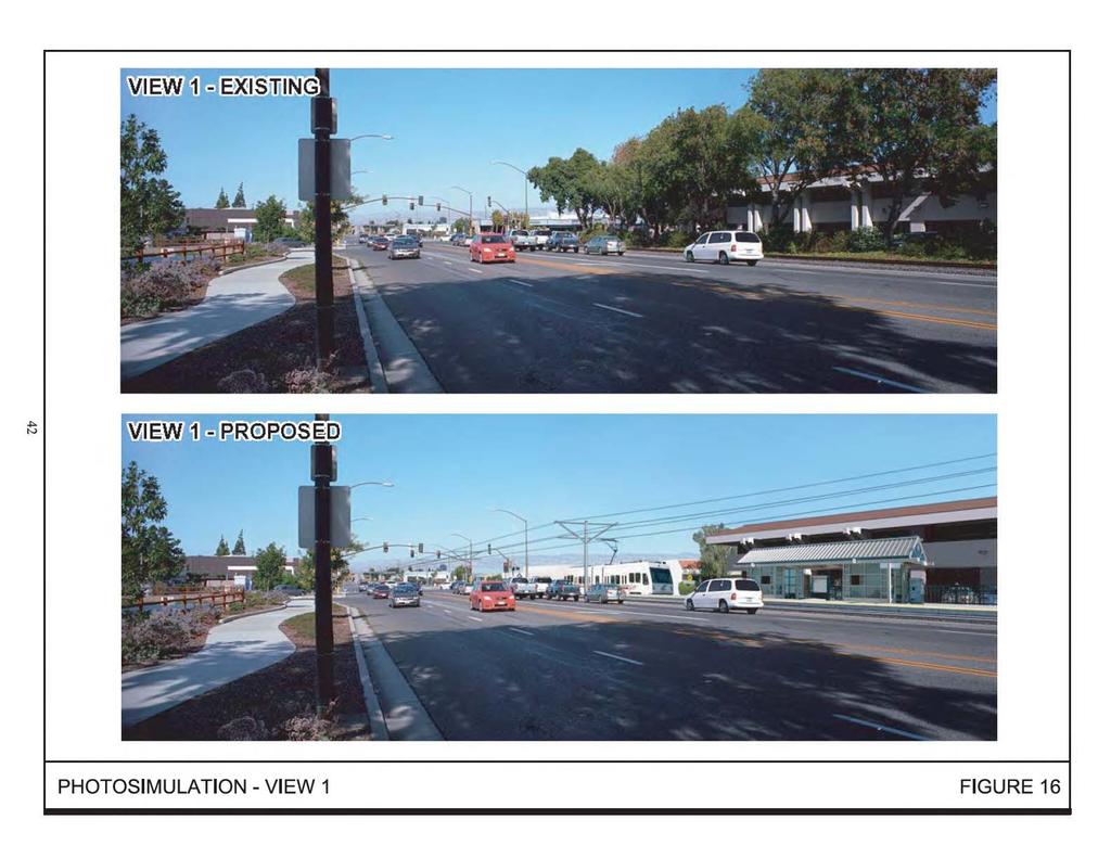
61
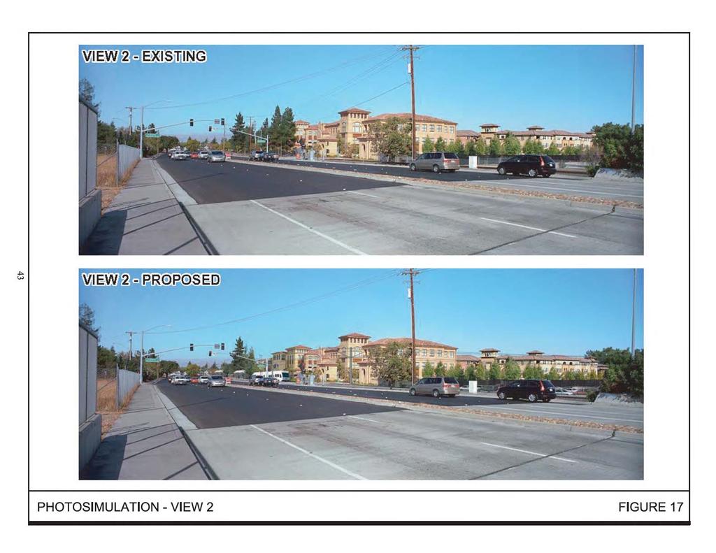
62
63 Implementation of the proposed project would result in the loss of numerous deciduous and evergreen landscaping trees of various sizes within the railroad ROW and temporary construction easements, which would alter but not significantly degrade the visual character of the site. Final design of the project would provide for the retention of as many landscaping trees as is practical. While the loss of landscaping trees along the project alignment would not be a significant visual impact, all trees removed would be replaced at the ratios shown below in Table 3, which is consistent with the replacement ratios proposed in the adopted Vasona Corridor Light Rail Transit Project Final EIS/EIR. (Less Than Significant Impact per CEQA; No Adverse Effect per NEPA) Light and Glare Impacts The light and glare effects of the project are primarily related to impacts to wildlife in the Los Gatos Creek Corridor. This effect, therefore, is discussed under Biological Resources Impacts in Section Lighting of the new/expanded park-and-ride lots is not expected to result in substantial light or glare impacts on adjacent land uses. The lighting fixtures would be designed and installed to focus light downward and to prevent light spillover to the maximum extent practicable Mitigation and Avoidance Measures for Visual Impacts While no significant visual impact was identified related to the loss of landscaping trees, all trees removed would be replaced as shown in Table 4, which is consistent with replacement ratios in the adopted Vasona Corridor Light Rail Transit Project Final EIS/EIR. Table 4 shows tree replacement ratios for ornamental trees impacted by the project. Native trees, such as the Coast Live Oaks on the Vasona Junction park-andride lot site, have a different mitigation requirement, as discussed in Section Replacement trees would be installed in an environment suitable for their establishment and growth and would be irrigated and maintained for a period of not less than three years. TABLE 3 Replacement Ratios for Trees Impacted by the Project Diameter of Tree Removed Replacement Ratio Replacement Tree Size 1.0 to 11.0 inches 1:1 15 gallon 12.0 to 17.0 inches 2:1 24-inch box 18.0 inches or greater 4:1 24-inch box Source: Vasona Corridor Light Rail Transit Project Final EIS/EIR, VTA, March Conclusion The proposed project would be visually compatible with all adjacent and nearby land uses and would not significantly impact the visual character of the project area. (Less Than Significant Impact per CEQA; No Adverse Effect per NEPA) Vasona Corridor Light Rail Transit Extension 44 Draft SEIR/EA Santa Clara County, California November 2012
64 Implementation of the proposed project would not result in any new visual impacts or impacts of greater severity than were identified in the Vasona Corridor Light Rail Transit Project Final EIS/EIR. Vasona Corridor Light Rail Transit Extension 45 Draft SEIR/EA Santa Clara County, California November 2012
65 4.3 GEOLOGY AND SOILS Existing Setting The project alignment is located in the central portion of the Santa Clara Valley. The region is characterized by northwest-trending ridges and valleys that parallel northwesttrending folds and strike-slip faults. Los Gatos Creek flows northward, generally parallel to the Vasona Corridor. The topography of the project area is relatively flat with an elevation of approximately 200 feet above mean sea level (msl) at the Winchester Station to 280 feet above msl at the Vasona Junction site. The San Francisco Bay Area is classified as Zone 4 for seismic activity, the most seismically active region in the United States. Strong ground shaking can, therefore, be expected along the project alignment during moderate to severe earthquakes in the general region. The significant earthquakes that occur in the Bay Area are generally associated with crustal movement along well-defined active fault zones of the San Andreas Fault System. The nearest active fault zones to the project site are the Hayward, Calaveras, and San Andreas. Several smaller local faults, including the Piercy, Silver Creek, Monte Vista, and Evergreen, could also cause moderate ground shaking along the project alignment CEQA Thresholds of Significance For the purposes of this SEIR, a geologic impact is considered significant if the project would: expose people or structures to potential substantial adverse effects, including the risk of loss, injury, or death involving rupture of a known earthquake fault, strong seismic ground shaking, seismic-related ground failure (including liquefaction), or landslides; result in substantial soil erosion or the loss of topsoil; be located on a geologic unit or soil that is unstable or that would become unstable as a result of the project, and potentially result in on- or off-site landslide, lateral spreading, subsidence, liquefaction, or collapse; be located on expansive soil, as defined in Table 18-1-B of the Uniform Building Code, creating substantial risks to life or property; or have soils incapable of adequately supporting the use of septic tanks or alternative waste water disposal systems where sewers are not available for the disposal of waste water Geologic Impacts The site is within the seismically active San Francisco Bay Area and severe ground shaking is likely during the useful life for the project. LRT patrons would be exposed to hazards associated with severe ground shaking during a major earthquake on one of Vasona Corridor Light Rail Transit Extension 46 Draft SEIR/EA Santa Clara County, California November 2012
66 the region s active faults. The hazard is not unique to the project because it applies throughout the greater Bay Area. The proposed project would not increase exposure to seismic related hazards as the hazard risk would be the same with or without the project. Implementation of the proposed project would include standard excavation and grading practices necessary to accommodate the LRT alignment and stations/park-andride lots. Standard engineering practices would be used to ensure that geotechnical and soil hazards do not result from the project. The project would be designed and constructed in accordance with the requirements of the Uniform Building Code for Seismic Zone 4 to avoid or minimize possible damage from ground shaking. Seismic impacts would be less than significant because the project would utilize standard engineering techniques mandated by the Uniform Building Code. (Less Than Significant Impact per CEQA; No Adverse Effect per NEPA) Mitigation and Avoidance Measures for Geology and Soils Impacts No mitigation measures are required or proposed Conclusion The proposed project would not result in significant geologic or soils impacts. Implementation of the proposed project would not result in any new geologic impacts or impacts of greater severity than were identified in the Vasona Corridor Light Rail Transit Project Final EIS/EIR. (Less Than Significant Impact per CEQA; No Adverse Effect per NEPA) Vasona Corridor Light Rail Transit Extension 47 Draft SEIR/EA Santa Clara County, California November 2012
67 4.4 HYDROLOGY AND WATER QUALITY The following information is based in part on a hydrology and water quality assessment prepared by Schaaf & Wheeler in November 2009 (see Appendix B) Stormwater Runoff Regulatory Setting State Water Quality Control Board National Pollutant Discharge Elimination System Permit The Porter-Cologne Water Quality Control Act and Federal Clean Water Act (CWA) require local municipalities to implement measures to control construction and postconstruction pollution entering local storm drainage systems to the maximum extent practicable. To comply with the requirements of the Porter-Cologne Water Quality Control Act and the Federal CWA, the State Water Resources Control Board (SWRCB) implemented a National Pollution Discharge Elimination System (NPDES) permit for the Santa Clara Valley. Two programs, the Nonpoint Source Pollution Program and the Santa Clara Valley Urban Runoff Pollution Prevention Program (SCVURPPP), have been implemented under the NPDES permit to control construction and postconstruction runoff Nonpoint Source Management Plan In 1988, the SWRCB adopted the Nonpoint Source Management Plan in an effort to control nonpoint source pollution in California. In December 1999, the Plan was updated to comply with the requirements of Section 319 of the CWA and Section 6217 of the Coastal Zone Act Reauthorization Amendment of The Nonpoint Source Management Plan requires individual permits to control discharge associated with construction activities. The Nonpoint Sources Management Plan is administered by the Regional Water Quality Control Board (RWQCB) under the NPDES General Permit for Storm Water Discharges Associated with Construction and Land Disturbance Activities, commonly referred to as the Construction General Permit. Projects must comply with the requirements of the Nonpoint Source Program if: they disturb one acre or more of soil 5 ; or they disturb less than one acre of soil but are part of a larger development that, in total, disturbs one acre or more of soil. The NPDES permit requires the developer to submit a Notice of Intent (NOI) and project registration documents to the RWQCB and to develop a Stormwater Pollution 5 Effective July 1, 2010, all dischargers will be required to obtain coverage under the Construction General Permit Order DWQ adopted on September 2, Source: State Water Resources Control Board website, updated September 24, 2009, Vasona Corridor Light Rail Transit Extension 48 Draft SEIR/EA Santa Clara County, California November 2012
68 Prevention Plan (SWPPP) prior to the commencement of construction to control discharge associated with construction activities. 6 Once grading begins, the SWPPP must be kept on-site and updated as needed while construction progresses. The SWPPP details the site-specific BMPs to control erosion and sedimentation and maintain water quality during the construction phase. The SWPPP also contains a summary of the structural and non-structural BMPs to be implemented during the post-construction period, pursuant to the nonpoint source control practices and procedures encouraged by the RWQCB Santa Clara Valley Urban Runoff Pollution Prevention Program The SCVURPPP was developed by the RWQCB to assist in the implementation of the provisions of the NPDES permit. This program was also designed to fulfill the requirements of Section 304(1) of the Federal CWA, which mandates that the U.S. Environmental Protection Agency develop NPDES application requirements for stormwater runoff. The Program s Municipal Regional Stormwater NPDES permit (adopted on October 14, 2009) replaces the formerly separate countywide municipal stormwater permits with one permit for all 76 Bay Area municipalities to standardize requirements throughout the region. It specifies actions necessary to reduce the discharge of pollutants in stormwater to the maximum extent practicable and effectively prohibits non-stormwater discharges into the municipal storm drainage system to protect local creeks and the Bay. Applicable projects consist of all new public and private projects that create 10,000 square feet or more of impervious surface collectively over the entire project site and redevelopment projects that add or replace 10,000 square feet or more of impervious surface area on the project site. Additional requirements must be met by large projects that create one acre or more of impervious surfaces. These large projects must control increases in runoff peak flow, volume, and duration (referred to as hydromodification) caused by the project if the increase in stormwater runoff has the potential to cause erosion or other adverse impacts to receiving streams. Stormwater from the proposed Vasona Junction Station and optional Hacienda Station park-and-ride lots would drain into the existing storm drainage systems on these sites, which are owned and operated by the Town of Los Gatos and the City of Campbell, respectively. Both jurisdictions are permittees under the Municipal Regional Stormwater NPDES permit. While VTA is not a permittee under the regional permit, VTA will be required to comply with the regional permit as their facilities will utilize storm drainage systems that are subject to the terms and conditions of the regional permit Hydromodification Hydromodification is a change in stormwater runoff characteristics from a watershed caused by changes in land use conditions (i.e., urbanization) that alter the natural 6 Santa Clara Valley Urban Runoff Pollution Prevention Program, Stormwater Pollution Control Requirements, updated December 5, Vasona Corridor Light Rail Transit Extension 49 Draft SEIR/EA Santa Clara County, California November 2012
69 cycling of water. Changes in land use conditions can cause runoff volumes and velocity to increase which can result in a decrease in natural vegetation, changing of river/creek bank grades, soil compaction, and the creation of new drainages. In addition to water quality controls, the SCVURPPP NPDES permit has hydromodification controls as defined in the Hydromodification Management Plan (HMP). The NPDES permit requires all new and redevelopment projects that create or replace one acre or more of impervious surface to manage development-related increases in peak runoff flow, volume, and duration, where such hydromodification is likely to cause increased erosion, silt pollutant generation or other impacts to beneficial uses of local rivers, streams, and creeks. Projects may be deemed exempt from the permit requirements if they do not meet the size threshold, drain into tidally influenced areas or directly into the Bay, drain into hardened channels, or are infill projects in subwatersheds that are 65 percent or more built out based on the SCVURPPP watershed map (as amended March 2009). Based on the SCVURPPP Santa Clara County Hydromodification Applicability Map, the Hacienda site is exempt from the NPDES hydromodification requirements because it is located within a subwatershed that is 65 percent or more built out. The Vasona Junction site is within an a subwatershed that is less than 65 percent built out and is subject to the HMP permit requirements Existing Setting Hacienda Park-and-Ride Lot Site The revised design for the Hacienda Station includes an optional park-and-ride lot at the northeast corner of Hacienda Avenue and Winchester Boulevard. These three parcels were not part of the original proposed project and, as a result, the hydrological conditions of these sites were never analyzed. Under existing conditions, the optional Hacienda site is completely developed except for a small area of perimeter landscaping. Due to the current development on-site, the site is approximately 97 percent covered with impermeable surfaces. The buildings are currently occupied by various automotive repair facilities. Runoff from the site already contains sediments, debris, oils, metals, and other pollutants related to automobiles and the urban environment. Stormwater runoff is not currently treated before entering the storm drainage system. Vasona Junction Park-and-Ride Lot Site The revised design for the Vasona Junction Station includes development of the SCVWD parcels immediately south of the Netflix/Aventino Apartment complex as a park-and-ride lot. Vasona Corridor Light Rail Transit Extension 50 Draft SEIR/EA Santa Clara County, California November 2012
70 The Vasona Junction site is an entirely permeable dirt lot. Runoff from the site would be minimal due to absorption of surface water into the soil. Runoff from the site likely contains sediment and biological debris. Because the site is undeveloped, runoff is not currently treated before entering the storm drainage system. Winchester Park-and-Ride Lot Site Full build out of the Winchester Station and park-and-ride lot was analyzed in the Vasona Corridor Light Rail Transit Project Final EIS/EIR. The Final EIS/EIR states that development of the Winchester park-and-ride lot would be consistent with the stormwater control requirements of the RWQCB. Since certification of the Final EIS/EIR, the RWQCB stormwater control requirements have been updated. As a result, the Winchester Station park-and-ride lot expansion has been re-analyzed in light of the new construction mitigation requirements. The Winchester expansion site is completely developed except for some perimeter landscaping and some landscape trees within the parking lot. Due to the current development on-site, the site is approximately 85 covered with impermeable surfaces Flooding Based on the Federal Emergency Management Agency s (FEMA) Flood Insurance Rate Maps (Map No C0239H, dated May 18, 2009), the 1.6-mile project alignment between the Winchester and Vasona Junction Stations is not within any 100-year floodplains. 7 The Hacienda park-and-ride lot site is also lot is also located outside the 100-year floodplain, as is all but the extreme easterly portion of the Vasona Junction park-and-ride lot site. A small portion of the Vasona Junction park-and-ride site adjacent to Los Gatos Creek may encroach into the 100-year floodplain. Dam Inundation Dam failure is another potential flooding source in the greater project area. Both the Vasona Dam and Reservoir and the Lexington Dam and Reservoir are located upstream of the Vasona Junction and Hacienda park-and-ride sites. Based on the California Office of Emergency Services Dam Inundation Maps, neither site would be affected by failure of the Vasona or Lexington Dam. The California Department of Water Resources inundation map indicates, however, that the Vasona Junction parkand-ride site could be inundated up to two feet deep by failure of Lexington Dam Storm Drainage System The City of Campbell owns and maintains the storm drainage system that serves the Hacienda site. Within the City of Campbell, the storm drainage lines collect water and convey it to Los Gatos Creek and San Tomas Aquino Creek, both of which flow to San 7 The 100-year floodplain is the areas that would be inundated during a flood that is expected to occur at least once in a 100-year period. It is sometimes referred to as the one percent flood because it has a one percent change of occurring in any given year. Vasona Corridor Light Rail Transit Extension 51 Draft SEIR/EA Santa Clara County, California November 2012
71 Francisco Bay. The Hacienda site drains into Los Gatos Creek. There is no overland release of stormwater directly into Los Gatos creek from the site; all stormwater enters the creek through the existing stormwater drainage system. The Town of Los Gatos owns and maintains the storm drainage system that serves the Vasona Junction site. There is no existing infrastructure on-site for the transport of stormwater runoff. Stormwater runoff from the site appears to drain mostly to the northeast towards the Netflix parking lot and towards the Los Gatos Creek. Some of the site may alternatively drain towards SR 85 at the southeast corner of the site Impaired Waterways Los Gatos Creek is adjacent to the Vasona Junction park-and-ride lot site. The water quality of Los Gatos Creek is directly affected by pollutants contained in stormwater runoff from a variety of urban and non-urban uses. Stormwater from urban uses contains metals, pesticides, herbicides, and other contaminants, including oil, grease, asbestos, lead, and animal wastes. Currently, Los Gatos Creek is listed on the California 303(d) list 8 for Diazinon 9 (Category 4A) and is being addressed by an approved U.S. Environmental Protection Agency (EPA) Total Maximum Daily Load (TMDL) Groundwater Groundwater within Santa Clara County is managed by the SCVWD. Typically, shallow groundwater is found near creeks and depths fluctuate depending on the amount of water in the waterway. The current level of the shallow aquifer in the project area is unknown. The average depth to groundwater utilized for the public water supply near the Hacienda and Vasona Junction sites is 130 to 140 feet CEQA Thresholds of Significance For the purposes of this SEIR, a hydrology or water quality impact is considered significant if the project would: violate any water quality standards or waste discharge requirements; substantially deplete groundwater supplies or interfere substantially with groundwater recharge such that there would be a net deficit in aquifer volume or a lowering of the local groundwater table (e.g., the production rate of preexisting nearby wells would drop to a level which would not support existing land uses or planned uses for which permits have been granted); 8 The Clean Water Act, Section 303, establishes water quality standards and TMDL programs. The 303(d) list is a list of impaired water bodies. 9 Diazinon is a commonly used insecticide that is highly toxic to aquatic life at low levels. 10 A TMDL is a calculation of the maximum amount of a pollutant that a water body can receive and still meet water quality standards. The TMDL high priority schedule denotes the most severely impaired water bodies on the 303(d) list. Vasona Corridor Light Rail Transit Extension 52 Draft SEIR/EA Santa Clara County, California November 2012
72 substantially alter the existing drainage pattern of the site or area, including through the alteration of the course of a stream or river, or substantially increase the rate or amount of surface runoff in a manner which would result in flooding on- or off-site; substantially alter the existing drainage pattern of the site or area, including through the alteration of the course of a stream or river, in a manner which would result in substantial erosion or siltation on- or off-site; create or contribute runoff water which would exceed the capacity of existing or planned stormwater drainage systems or provide substantial additional sources of polluted runoff; otherwise substantially degrade water quality; place within a 100-year flood hazard area structures which would impede or redirect flood flows; expose people or structures to a significant risk of loss, injury or death involving flooding, including flooding as a result of the failure of a levee or dam; or inundation of the site by seiche, tsunami, or mudflow Hydrology and Water Quality Impacts Flood Impacts As stated in Section , the entire project area except for the extreme easterly portion of the Vasona Junction park-and-ride lot site is located outside the 100-year floodplain. No structures are proposed to be constructed in the portion of the Vasona Junction park-and-ride site that may lie within the 100-year floodplain. Furthermore, the project would not impede or redirect flood flows to other properties. The proposed project sites are located approximately 10.5 miles and 11.2 miles south of the San Francisco Bay respectively and are at elevations of 230 and 280 feet above sea level with relatively flat topography. As a result, the project sites would not be subject to inundation by a seiche, tsunami, or mudflow. Implementation of the proposed project would not subject people or new development to flooding hazards. (Less Than Significant Impact per CEQA; No Adverse Effect per NEPA) Storm Drainage Impacts As stated in Section 4.4.2, the Hacienda site is approximately 97 percent covered with impermeable surfaces. Construction of the optional park-and-ride lot would slightly decrease the impermeable surface area of this site. The existing storm drainage system is of sufficient capacity to support the existing development and, therefore, would be able to support the proposed project. Implementation of the optional Hacienda park-and-ride lot would have no impact on the capacity of the existing storm drainage system. Vasona Corridor Light Rail Transit Extension 53 Draft SEIR/EA Santa Clara County, California November 2012
73 The Vasona Junction site is an entirely permeable dirt lot. There is no existing infrastructure on-site for the transport of stormwater runoff. Stormwater runoff from the site appears to drain mostly to the northeast towards the Netflix parking lot and towards Los Gatos Creek. Some of the site may alternatively drain towards SR 85 at the southeast corner of the site. Construction of the Vasona Junction park-and-ride lot would result in the majority of the site being covered in impermeable surfaces, which in turn would substantially increase the amount of stormwater runoff from the site. The additional stormwater would be collected by a storm drain system to be built as part of the park-and-ride lot. The collected stormwater would be treated as described below under Water Quality Impacts. The treated water would be discharged to the adjacent storm drainage system, which has capacity to accommodate the increased volume. (Less Than Significant Impact per CEQA; No Adverse Effect per NEPA) Water Quality Impacts Stormwater runoff from the Hacienda, Vasona Junction park-and-ride lot sites and from the expansion site for the Winchester park-and-ride lot site is not currently treated before entering the storm drainage system or sheet flowing off-site. Operational Impacts Implementation of the project could result in a substantial increase in potential stormwater pollutant loads due to the addition of impermeable surfaces to the Vasona Junction site. The site would likely contribute the same types of stormwater runoff pollutants as the surrounding development. Runoff from streets and parking areas often carries grease, oil, and trace amounts of heavy metals into natural drainages. Runoff from landscaping can carry pesticides, herbicides, and fertilizers. Although the amounts of these pollutants ultimately discharged into the waterways are unknown, over time they could be substantial. The project would result in a substantial net increase in impervious surfaces on the Vasona Junction park-and-ride lot site and would add or replace more than 5,000 square feet of impervious surfaces 11 at the Vasona Junction, Winchester, and Hacienda park-and-ride lot sites. In addition, the project would construct two new LRT stations that would add or replace more than 10,000 square feet of impervious surfaces. As a result of the increase in impermeable surfaces, the pollutant load in stormwater runoff from these sites and the amount of runoff and pollution flowing into the storm drain system could also increase. Because the VTA would be utilizing existing storm drainage systems owned and operated by permittees of the Municipal Regional Stormwater NPDES permit, the project must comply with the requirements of the regional permit. A numerically sized 11 Uncovered parking lots are classified as a special land use category under the municipal permit. As of December 1, 2011, the threshold for special land uses was reduced from 10,000 square feet to 5,000 square feet. Vasona Corridor Light Rail Transit Extension 54 Draft SEIR/EA Santa Clara County, California November 2012
74 Stormwater Control Plan that meets the adopted Low Impact Development requirements would ensure incorporation of appropriate and effective source control measures to prevent discharge of pollutants, design measures to reduce impervious surfaces, and treatment control measures to remove pollutants from runoff. The proposed project would implement harvesting and re-use, infiltration, evapotranspiration, or biotreatment measures as required to reduce and treat stormwater runoff from the project site. The proposed treatment facilities would be numerically sized, in accordance with municipal permit requirements, to treat all the stormwater runoff entering the storm drainage system. Implementation of a Stormwater Control Plan, consistent with NPDES requirements, would ensure that the project avoids violation of any adopted water quality standards or waste discharge requirements. Runoff would be routed directly from the treatment facilities to the storm drainage system and would not flow off-site. (Less Than Significant Impact per CEQA; No Adverse Effect per NEPA) The proposed platform extensions at the existing stations would not individually increase impervious surfaces by more than 10,000 square feet. Because the increase would not exceed the RWQCB threshold, the long-term impact of the platform extensions would be less than significant. (Less Than Significant Impact per CEQA; No Adverse Effect per NEPA) Construction Impacts Construction of the park-and-ride lot at the Vasona Junction Station would involve grading and paving on the top of the slope above the Los Gatos Creek Trail and upslope of the creek. These activities could result in sediment and contaminants entering the creek, which would impact the water quality of the creek. Surface runoff from the Hacienda park-and-ride lot site and the Winchester park-andride lot expansion site enters the existing storm drain system and drains into Los Gatos Creek. Demolition of the existing buildings and pavement and construction of the parkand-ride lots could result in debris, sediment, and contaminants entering the creek, which would impact the water quality of the creek. Impact HYDO -1.1: Construction of the proposed Vasona Junction park-and-ride lot and optional Hacienda park-and-ride lot, and expansion of the Winchester park-and-ride lot could temporarily impact the water quality of Los Gatos Creek. (Temporary Significant Impact per CEQA; Adverse Effect per NEPA) Relocation of the freight tracks and installation of the double LRT tracks would not require extensive earth moving and would not expose a substantial amount of soil currently covered by hardscape. As a result, these construction activities would not result in a substantial increase in sediments or contaminants entering local storm drainage systems or creeks. (Less Than Significant Impact per CEQA; No Adverse Effect per NEPA) Vasona Corridor Light Rail Transit Extension 55 Draft SEIR/EA Santa Clara County, California November 2012
75 Hydromodification The Vasona Junction site is located adjacent to Los Gatos Creek, which is a natural creek channel in this area. Based on the HMP map, the site is located within an area that could be affected by hydromodification. Any increase in the velocity of stormwater flow into the creek could cause the creek bank to erode. As a result, development of the Vasona Junction Station would be required to comply with the applicable hydromodification permit regulations in place at the time of development. The final design of the Stormwater Control Plan would ensure that the rate and flow of the stormwater entering Los Gatos Creek in the project area does not increase as a result of the project. This could include retention of stormwater on-site and/or perforated drainage lines to allow for greater percolation as well as limiting the amount of stormwater that can enter the storm drainage system at any one time. Because the project is required to be in compliance with permit regulations, the proposed project would have a less than significant hydromodification impact. (Less Than Significant Impact per CEQA; No Adverse Effect per NEPA) Groundwater As stated previously, the Hacienda park-and-ride lot site is approximately 97 percent covered with impervious surfaces. If the optional park-and-ride lot were to be built on this site, the amount of impervious surfaces on-site would be roughly equal to the existing condition. The site does not currently contribute to recharging of the groundwater aquifer and implementation of the proposed project would not alter this condition. Therefore, construction of the optional Hacienda park-and-ride lot would have no impact on the groundwater aquifer. The Vasona Junction park-and-ride lot is currently unpaved and is located with the SCVWD s identified groundwater recharge area for the Santa Clara Basin. The site, however, is unlikely to contribute significantly to groundwater recharge due to the relatively small surface area of the site, the absence of a water body on-site, and the compacted condition of the surface soils. Therefore, even with a substantial increase in impervious surfaces on the Vasona Junction park-and-ride lot site, the project would have a less than significant impact on the groundwater aquifer. (Less Than Significant Impact per CEQA; No Adverse Effect per NEPA) Other Surface Water Hazards Dam Inundation As stated above, neither the Hacienda or Vasona Junction sites would be affected by failure of the Vasona or Lexington Dam according to the California Office of Emergency Services Dam Inundation Maps. The California Department of Water Resources inundation map indicates, however, that the Vasona Junction park-and-ride site could be inundated up to two feet deep by failure of Lexington Dam. 12 This dam is under the 12 Dam failure(s) would affect many square miles of land, including much of Los Gatos and portions of Campbell and San José. Vasona Corridor Light Rail Transit Extension 56 Draft SEIR/EA Santa Clara County, California November 2012
76 jurisdiction of the Department of Water Resources, which requires periodic inspections to assure that the dams are adequately maintained. The regular inspection and required maintenance of Lexington Dam substantially reduces the potential for catastrophic failure. In addition, the project would not any permanent structures on-site that would allow people to congregate on-site for any length of time. The risk of inundation to any site users would be minimal. Therefore, implementation of the proposed project would not put any persons in danger from inundation due to dam failure. (Less Than Significant Impact per CEQA; No Adverse Effect per NEPA) Mitigation and Avoidance Measures for Hydrology and Water Quality Impacts The following project-specific mitigation measures will be implemented to reduce construction-related water quality impacts: All active paved construction areas will be swept and washed daily. Linear sediment barriers such as silt fencing, fiber rolls, or other equivalent measures will be used to retain sediment on the project site. Temporary cover of all disturbed surfaces will be provided, consistent with the requirements of the Construction General Permit, to help prevent erosion Permanent cover/revegetation will be provided to stabilize the disturbed surfaces after construction has been completed. No debris, soil, silt, sand, bark, vegetative cutting, sawdust, cement, concrete, washings, petroleum products, or other organic or earthen material will be allowed to enter into or be placed where it may be washed by rainfall or runoff into Los Gatos Creek. Earthmoving or other dust-producing activities will be suspended during periods of high winds. All trucks hauling soil, sand, or other loose materials will be covered. A Storm Water Permit will be administered by the RWQCB. Prior to construction grading for the proposed land uses, the project proponent will file project record documents (PRDs) to comply with the Construction General Permit. The PRDs include the Notice of Intent (NOI) and the SWPPP, which addresses measures that would be included in the project to minimize and control construction and postconstruction runoff. Measures will include, but are not limited to, the aforementioned mitigation. VTA will upload a copy of the approved SWPPP to the RWQCB on-line Stormwater Multi-Application and Reporting Tracking System (SMARTS) for review and approval Vasona Corridor Light Rail Transit Extension 57 Draft SEIR/EA Santa Clara County, California November 2012
77 prior to start of construction on the project site. The certified SWPPP will be available at the project site and will be updated to reflect current site conditions. When construction is complete, a Notice of Termination (NOT) for the Construction General Permit will be filed with the RWQCB. The NOT will document that all elements of the SWPPP have been executed, construction materials and waste have been properly disposed of, and a post-construction storm water management plan is in place as described in the SWPPP for the site Conclusion With implementation of the identified mitigation measures listed above, the project would result in less than significant temporary impacts on stormwater quality. The project would not deplete the groundwater supply, substantially degrade water quality, or subject anyone to flood hazards. The project would not increase stormwater runoff beyond the capacity of the existing stormwater drainage system. Implementation of the proposed project would not result in any new hydrology or water quality impacts or impacts of greater severity than were identified in the Vasona Corridor Light Rail Transit Project Final EIS/EIR. (Less Than Significant Impact with Mitigation per CEQA; No Adverse Effect with Mitigation per NEPA) Vasona Corridor Light Rail Transit Extension 58 Draft SEIR/EA Santa Clara County, California November 2012
78 4.5 BIOLOGICAL RESOURCES The following information is based in part on a Biological Resources report prepared by H.T. Harvey & Associates in December 2010 and a tree survey prepared by John Steinbach Certified Arborist in October 2009 (see Appendices C and D, respectively) Regulatory Setting Federal laws and regulations pertaining to wildlife include the Migratory Bird Treaty Act and the Fish and Wildlife Coordination Act. State laws and regulations pertaining to wildlife include Sections of the Fish and Game Code, as well as Sections 4150 and 4152 of the Fish and Game Code. Wetlands and other waters are protected under a number of laws and regulations. At the federal level, the Federal Water Pollution Control Act, more commonly referred to as the Clean Water Act [CWA (33 USC 1344)] is the primary law regulating wetlands and surface waters. The CWA regulates the discharge of dredged or fill material into waters of the United States (U.S.), including wetlands. At the state level, wetlands and waters are regulated primarily by the California Department of Fish and Game (CDFG), the State Water Resources Control Board (SWRCB) and the RWQCB. The primary federal law protecting threatened and endangered species is the Federal Endangered Species Act (FESA): 16 USC Section 1531, et seq. See also 50 CFR Part 402. This act and subsequent amendments provide for the conservation of endangered and threatened species and the ecosystems upon which they depend. Under Section 7 of this act, federal agencies, such as the FTA, are required to consult with the U.S. Fish and Wildlife Service (USFWS) and the National Oceanic and Atmospheric Administration s National Marine Fisheries Service (NMFS) to ensure that they are not undertaking, funding, permitting or authorizing actions likely to jeopardize the continued existence of listed species or destroy or adversely modify designated critical habitat. California has enacted a similar law at the state level, the California Endangered Species Act (CESA), California Fish and Game Code, Section 2050, et seq. CESA emphasizes early consultation to avoid potential impacts to rare, endangered, and threatened species and to develop appropriate planning to offset project caused losses of listed species populations and their essential habitats. The CDFG is the agency responsible for implementing CESA. Section 2081 of the Fish and Game Code prohibits "take" of any species determined to be an endangered species or a threatened species. Take is defined in Section 86 of the Fish and Game Code as "hunt, pursue, catch, capture, or kill, or attempt to hunt, pursue, catch, capture, or kill." Existing Setting The revised design for the Vasona Junction Station includes development of the SCVWD parcels immediately south of the Netflix/Aventino Apartment complex. The SCVWD parcels would be developed as a park-and-ride lot. The revised design for the Vasona Corridor Light Rail Transit Extension 59 Draft SEIR/EA Santa Clara County, California November 2012
79 Hacienda Station includes an optional park-and-ride lot at the northeast corner of Hacienda Avenue and Winchester Boulevard. These three parcels were not part of the original proposed project and, as a result, the habitat value and possible species occupation of these sites were not previously evaluated. Biological resources include plants and animals and the habitats that support them. Individual plant and animal species that are listed as rare, threatened, or endangered under the State and/or Federal Endangered Species Act, and the natural communities of habitats that support them, are of particular concern. Sensitive natural communities (e.g. wetlands, riparian woodlands, and oak woodland) that are critical to wildlife or ecosystem function are also important biological resources. The proposed location of the Hacienda park-and-ride lot is completely developed except for a small area of perimeter landscaping consisting of ornamental shrubs and a few immature trees. This site offers no habitat for migratory birds or species of special concern. No important habitat would be lost as a result of redevelopment of this parcel and no further biological analysis is presented in this document. Therefore, this analysis focuses on the possible biological resources on the Vasona Junction park-andride lot site Overview of Habitat Found at the Vasona Junction Park-and-Ride Lot Site Disturbed/Developed Habitat Park-and-Ride Lot Most of the Vasona Junction park-and-ride lot site is bare dirt and gravel. Stands of large trees, consisting of California coast live oak, pine, cedar, elm, and California pepper, as well as blue elderberry shrubs are located in the central area of the site. The site was, at one time, part of an oak woodland/savannah habitat community that is no longer in existence. Along the perimeter of the site are patches of ruderal non-native grasses. Mixed Riparian Habitat Los Gatos Creek Corridor The riparian corridor adjacent to the Vasona Junction park-and-ride lot site is a moderate to high quality riparian habitat that supports well developed, multi-layered vegetation. The vegetation includes an overstory of trees consisting of California coast live oak, valley oak, western sycamore, and several types of willow. Non-native trees including eucalyptus, acacia, and olive were also identified within the riparian habitat. The riparian corridor also includes a dense understory consisting of poison oak, coyote brush, blackberry, and blue elderberry. Aquatic Habitat Los Gatos Creek The aquatic habitat of Los Gatos Creek is located approximately 65 feet down slope from the Vasona Junction park-and-ride lot site. Water released from Lexington Reservoir provides constant and controlled flows through the creek channel. Small, Vasona Corridor Light Rail Transit Extension 60 Draft SEIR/EA Santa Clara County, California November 2012
80 sparse patches of herbaceous wetland plant species including tall umbrella sedge and dotted knotweed were observed within the channel Overview of Wildlife Found on the Vasona Junction Park-and-Ride Lot Site Disturbed and developed habitats, such as the Vasona Junction park-and-ride lot site, support a variety of common wildlife species adapted to the urban environment. Bird species typically found in these habitats include non-native house sparrows and European starlings and native species such as house finch, northern mockingbird, Anna s hummingbird, and black phoebe. Non-native mammal species typically found include Virginia opossum, house mouse, eastern gray squirrel, fox squirrel, Norway rat, and black rat. Native mammals that occupy this habitat typically include deer mouse, raccoon, and striped skunk Special Status Species Special status species are those plants and animals listed under the State and Federal Endangered Species Acts (including candidate species); plants listed on the California Native Plant Society s Inventory of Rare and Endangered Vascular Plants of California (1994); and animals designated as Species of Special Concern by the CDFG. Most special status animal species occurring in the Bay Area use habitats that are not present on the Vasona Junction park-and-ride lot site. Salt marsh, freshwater marsh, and serpentine grassland habitats are not present within or immediately adjacent to the site. A reconnaissance-level survey and records search was completed in 2010 to determine if habitats capable of supporting special status plant and wildlife species are located onsite. The records search including the California Natural Diversity Database (CNDDB), USFWS, California Native Plant Society (CNPS) Inventory of Rare and Endangered Plants of California, and the Draft Santa Clara Valley Habitat Conservation Plan (December 2010). Plant Species Forty-two special-status plant species were identified as occurring in various natural habitats in Santa Clara County. None of the 42 plant species identified are located within the project area because of one or more of the following facts: 1) a lack of specific habitat and/or soil requirements on-site, 2) the species is known to be extirpated from the area, 3) the site is outside the endemic or elevation range of the species, and/or 4) the degraded habitat conditions on-site will not support the species. Wildlife Species Twenty-three special-status animal species were identified as occurring in landscaped/developed, mixed riparian and aquatic habitats in Santa Clara County. Twenty of these species are absent from the project site because: 1) a lack of suitable habitat exists, 2) there are existing barriers between occupied habitat and the project Vasona Corridor Light Rail Transit Extension 61 Draft SEIR/EA Santa Clara County, California November 2012
81 area, and/or 3) there is evidence that the species no longer exist in the project area. The three special-status animal species that could possibly occur within the riparian and aquatic habitats adjacent to the Vasona Junction park-and-ride lot site are described below. Western Pond Turtle The western pond turtle is found in ponds, streams, and other wetland habitats. Ponds or slack-water pools 13 with suitable basking sites are an important habitat component. Females lay eggs in clay or silty soils in unshaded areas of upland habitats within a few hundred meters of aquatic habitat. Juveniles feed and grow in shallow aquatic habitats (often creeks) with emergent vegetation and ample invertebrate prey. Nesting habitat is typically found within 600 feet of aquatic habitat. Western pond turtles have been recorded approximately 0.8 miles upstream of the Vasona Junction park-and-ride lot site in Vasona Reservoir. They have also been recorded farther upstream in Lexington Reservoir and they have been seen in Los Gatos Creek between Vasona Reservoir and the Vasona Junction park-and-ride lot site. Local populations have decreased due to urbanization, predation and harassment by pets and non-native mammals, capture by humans, degradation of water quality, loss of upland nesting habitat, and construction of barriers between creeks and nesting areas. Suitable upland habitat is absent from the project area and it is highly unlikely that western pond turtles would occur on the project site. Turtles may, however, be located in the portion of Los Gatos Creek adjacent to the Vasona Junction park-and-ride lot site. The western pond turtle is classified as a California Species of Special Concern by CDFG. The status of the western pond turtle is currently under review by USFWS. California Yellow Warbler The California yellow warbler is a California species of special concern when nesting. Yellow warblers nest in riparian forests with open canopies and dense understories adjacent to open foraging habitat. Breeding populations have significantly declined in recent decades due to urbanization and disease. The riparian habitat within the Los Gatos Creek corridor, including along the Vasona Junction park-and-ride lot site, is seemingly adequate for nesting. Because of the surrounding development there is not, however, adequate foraging habitat on or near the project site. Regardless, it is remotely possible that yellow warblers could breed in the riparian habitat near the Vasona Junction park-and-ride lot site. The California yellow warbler is classified as a California Species of Special Concern by CDFG. The California yellow warbler is not listed by the USFWS. 13 Areas where there is little to no horizontal movement in the water. Vasona Corridor Light Rail Transit Extension 62 Draft SEIR/EA Santa Clara County, California November 2012
82 San Francisco Dusky-footed Woodrat The San Francisco dusky-footed woodrat (woodrat) occupies riparian and oak woodland forests with dense understory cover or thick chaparral habitat. While woodrats are locally common in many areas, loss of habitat, increased development, and increased populations of introduced predators (such as domestic cats) pose a substantial risk to the San Francisco subspecies. Woodrats are extremely sensitive to non-native predators and, as such, their distribution in the project area is limited. No woodrat nests were observed in the riparian habitat adjacent to the Vasona Junction park-and-ride lot site. Nevertheless, it is possible that foraging or dispersing individuals may be present in small numbers. The San Francisco dusky-footed woodrat is classified as a California Species of Special Concern by CDFG. The San Francisco dusky-footed woodrat is not listed by the USFWS Trees Vasona Junction Park-and-Lot Site Mature trees (both native and non-native) are beneficial because they provide nesting and foraging habitat for raptors and other migratory birds. To determine the possible habitat value of the trees on the proposed Vasona Junction park-and-lot site, a tree survey was completed in Trees located on the park-and-ride lot site are a mixture of native and non-native species, in varying sizes and levels of health. For the purposes of this report, trees were considered mature if they had a diameter of six inches or greater measured at 4.5 feet above grade. Seven of the eight trees on the Vasona Junction park-and-ride lot site measured six inches in diameter or greater at two feet above the ground surface. Trees measuring less than six inches in diameter are considered too small to be viable habitat. The following table lists the eight trees identified during the tree survey. Figure 18 shows the locations of the trees on-site. Table 4 lists the trees by the numbers referred on Figure 18 and in the arborist s report in Appendix D. Vasona Corridor Light Rail Transit Extension 63 Draft SEIR/EA Santa Clara County, California November 2012
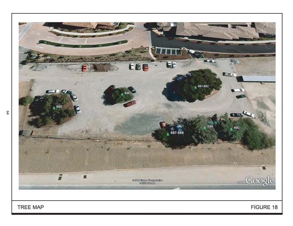
83
84 TABLE 4 TREE SURVEY Tree No. Common Name Diameter 14 Condition Preservation Suitability 685 California Pepper 26 Fair Moderate 686 Elm 21 Fair Poor 687 Coast Live Oak 6 Average Poor 688 Coast Live Oak 5 Average Poor 689 Pine 32 Average Good 690 Cedar 32 Average Poor 691 Coast Live Oak 42 Average Good 692 Coast Live Oak 62 Average Good Source: John Steinbach Certified Arborist CEQA Thresholds of Significance For the purposes of this SEIR, a biological resources impact is considered significant if the project would: have a substantial adverse effect, either directly or through habitat modifications, on any species identified as a candidate, sensitive, or special status species in local or regional plans, policies, or regulations, or by the CDFG or USFWS; have a substantial adverse effect on any riparian habitat or other sensitive natural community identified in local or regional plans, policies, or regulations or by the CDFG or USFWS; have a substantial adverse effect on federally protected wetlands as defined by Section 404 of the CWA (including, but not limited to, marsh, vernal pool, coastal, etc.) through direct removal, filling, hydrological interruption, or other means; interfere substantially with the movement of any native resident or migratory fish or wildlife species or with established native resident or migratory wildlife corridors, or impede the use of native wildlife nursery sites; conflict with any local policies or ordinances protecting biological resources, such as a tree preservation policy or ordinance; or conflict with the provisions of an adopted Habitat Conservation Plan, Natural Community Conservation Plan, or other approved local, regional, or state habitat conservation plan Biological Resources Impacts This analysis of biological impacts is based on the following assumptions: 1. No construction would occur within the bed and banks of Los Gatos Creek. 2. Once constructed, the park-and-ride lot s stormwater drainage would not outfall directly to Los Gatos Creek. Stormwater would be retained and re-used on-site or 14 The diameter is measured in inches. Vasona Corridor Light Rail Transit Extension 65 Draft SEIR/EA Santa Clara County, California November 2012
85 filtered on-site and discharged to the existing storm drainage system. Please see Section for details regarding stormwater drainage at Vasona Junction Impacts to Habitat Disturbed/Developed Habitat Vasona Junction Park-and-Ride Lot Implementation of the proposed project would result in the removal of four native California coast live oak trees at the Vasona Junction park-and-ride lot site. The oak trees are native species and their size and close proximity to the riparian corridor provide additional habitat to a variety of bird species that utilize the riparian corridor. Therefore, the loss of these four oak trees would be a significant impact. Impact BIO-1: Implementation of the proposed project would result in the loss of native coast live oak trees that provide habitat for bird species on the Vasona Junction park-and-ride lot site. (Significant Impact per CEQA; Adverse Effect per NEPA) Mixed Riparian Habitat Los Gatos Creek Corridor The mixed riparian habitat along the Los Gatos Creek adjacent to the Vasona Junction park-and-ride lot site is currently dominated by native trees and shrubs. Many ornamental plant species commonly used for landscaping are known invasives that reduce native plant species and degrade habitat quality. Per VTA standard practices, only native and drought tolerant plant species will be included in the landscape planting design for the Vasona Junction site. Invasive plant species, including those occurring on the California Invasive Plant Council watch list, would not be planted on-site. Therefore, implementation of the proposed project would not impact the variety or abundance of native plants within and along the Los Gatos Creek riparian corridor. (Not an Impact per CEQA; No Adverse Effect per NEPA) Impacts to Wildlife Nesting and Migratory Birds Several migratory bird species utilize the riparian habitat of Los Gatos Creek. Construction during the nesting season may disturb nesting individuals and could result in nest abandonment. Yellow warblers and other bird species are protected by the California Fish and Game Code and the Federal Migratory Bird Treaty Act (MBTA). The taking of an individual yellow warbler, a warbler egg, or nest would be a significant impact. The loss of an active nest of species protected by the California Fish and Game Code and/or MBTA is also a significant impact. Impact BIO-2: Construction of the proposed Vasona Junction park-and-ride lot during nesting season could result in the loss of individual yellow warblers, their nests, their eggs, and/or the loss of active nests of other migratory bird species. (Significant Impact per CEQA; Adverse Effect per NEPA) Vasona Corridor Light Rail Transit Extension 66 Draft SEIR/EA Santa Clara County, California November 2012
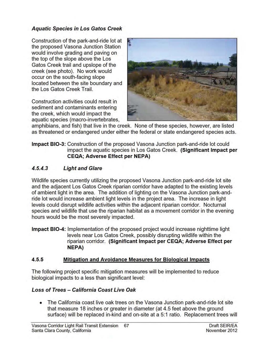
86
87 be either 15-gallon or 24-inch box specimens and will be purchased from local genetic stock. Replacement trees will be planted along the eastern property line. If there is not sufficient room available to plant all the replacement trees, the trees will be planted as near the riparian corridor as possible. Replacement trees will be irrigated for a minimum of two years. If sufficient planting areas are not available on-site, the oak trees may be planted along the upper banks of the Los Gatos Creek riparian corridor directly adjacent or within close proximity to the Vasona Junction park-and-ride lot site. Nesting and Migratory Birds When possible, construction activities will occur outside the breeding season for local bird species. Nesting season for most birds, including most raptors, in the San Francisco Bay Area extends from January 1 through August 31. Possible nesting areas (i.e., bushes, trees, grass, buildings, burrows) that will be removed as part of the project will be removed between September 1 and December 31 to preclude nesting. If it is not possible to schedule demolition and construction and removal of nesting areas between September and January, then pre-construction surveys for nesting birds will be completed by a qualified ornithologist to ensure that no nests will be disturbed during project implementation. The first of these surveys will be completed no more than 14 days prior to the initiation of grading, tree removal, or other demolition or construction activities. The second survey will be completed 48 hours prior to the start of construction. During these surveys, the ornithologist will inspect all trees and other possible nesting habitats within and immediately adjacent to the construction areas for nests. If an active nest is found sufficiently close to work areas to be disturbed by construction, the ornithologist, in consultation with CDFG, will determine the extent of a construction-free buffer zone to be established around the nest, typically 250 feet, to ensure that raptor or migratory bird nests will not be disturbed during project construction. Any buffer zones established to protect nesting birds will be removed when then ornithologist has confirmed the nest is no longer active and CDFG has given written approval. Vasona Corridor Light Rail Transit Extension 68 Draft SEIR/EA Santa Clara County, California November 2012
88 Aquatic Species in Los Gatos Creek Stormwater control measures will be implemented during all phases of construction consistent with the measures listed in Section 4.4, Hydrology and Water Quality of this SEIR/EA. Machinery on-site will not be refueled within 60 feet from the top of the creek bank. A Spill Prevention and Response Plan, which includes appropriate construction worker training, will be developed and implemented during construction. Light and Glare Low-glare, low intensity lighting will be used within the Vasona Junction parkand-ride lot and will be shielded to direct light away from the riparian corridor. Lighting elements will be placed as close to ground level as possible while still providing sufficient light for pedestrians, bicyclists, and drivers to maneuver safely through the lot. Landscaping between the Vasona Junction park-and-ride lot and the Los Gatos Creek corridor will be designed to screen the riparian corridor and shield it from the on-site lighting Conclusion Implementation of the proposed mitigation measures will reduce the identified biological impacts to a less than significant level. (Less Than Significant With Mitigation per CEQA; No Adverse Effect with Mitigation per NEPA) Vasona Corridor Light Rail Transit Extension 69 Draft SEIR/EA Santa Clara County, California November 2012
89 4.6 HAZARDS AND HAZARDOUS MATERIALS The following information is based in part on a Phase I Environmental Site Assessment prepared by Baseline Environmental Consulting in September 2010 (see Appendix E) Regulatory Setting Hazardous materials and hazardous wastes are regulated by many state and federal laws. These include not only specific statutes governing hazardous waste, but also a variety of laws regulating air and water quality, human health and land use. The primary federal laws regulating hazardous wastes/materials are the Resource Conservation and Recovery Act of 1976 (RCRA) and the Comprehensive Environmental Response, Compensation and Liability Act of 1980 (CERCLA). The purpose of CERCLA, often referred to as Superfund, is to clean up contaminated sites so that public health and welfare are not compromised. RCRA provides for "cradle to grave" regulation of hazardous wastes. Other federal laws include: Community Environmental Response Facilitation Act of 1992 Clean Water Act Clean Air Act Safe Drinking Water Act Occupational Safety and Health Act (OSHA) Atomic Energy Act Toxic Substances Control Act Federal Insecticide, Fungicide, and Rodenticide Act Hazardous waste in California is regulated primarily under the authority of the federal Resource Conservation and Recovery Act of 1976, and the California Health and Safety Code. Other California laws that affect hazardous waste are specific to handling, storage, transportation, disposal, treatment, reduction, cleanup and emergency planning. Worker health and safety and public safety are key issues when dealing with hazardous materials that may affect human health and the environment. Proper disposal of hazardous material is vital if it is disturbed during project construction Existing Setting The revised design for the Vasona Junction Station includes development of the SCVWD parcels immediately south of the Netflix/Aventino Apartment complex as a park-and-ride lot. The revised design for the Hacienda Station includes an optional park-and-ride lot at the northeast corner of Hacienda Avenue and Winchester Boulevard. These three parcels were not part of the original proposed project and the potential for on-site contamination was never analyzed. The park-and-ride lot at the Winchester Station would also be expanded. The proposed expansion is consistent with the original project. Nevertheless, the status of the site could have changed since Vasona Corridor Light Rail Transit Extension 70 Draft SEIR/EA Santa Clara County, California November 2012
90 the original analysis was completed in Therefore, all of these parcels are included in the analysis below Historical Land Uses of the Project Sites Winchester Station Historically the land uses on and around the Winchester Station site were mostly agricultural. By the 1950 s, agricultural lands had declined and housing was abundant in the area. By the 1970 s, commercial development began to replace the remaining agricultural land. The Winchester Station and park-and-ride lot were constructed in Currently, the Winchester Station is adjacent to residential and commercial development, including a plant nursery and a church. Hacienda Station Similar to the Winchester Station site, historical land uses on and around the Hacienda Station site were mostly agricultural. By the 1950 s, housing was prominent and by the 1970 s, commercial and industrial development began to replace the remaining agricultural land. The proposed Hacienda Station site is located primarily within the railroad ROW but would also encompasses a portion of a parking lot adjacent to a medical building. The optional park-and-ride lot site is occupied by several automotive related businesses and is adjacent to commercial and industrial development. There is also a gas station approximately 200 feet west of the site (on the northwest corner of the Hacienda Avenue and Winchester Boulevard intersection) that was constructed around Vasona Junction Station Historical land uses on and adjacent to the Vasona Junction Station site included orchards and a commercial plant nursery. The proposed Vasona Junction Station site is located primarily within the railroad ROW but would also encompasses a portion of a parking lot adjacent to a commercial office building (Netflix). The park-and-ride lot site is comprised of two vacant parcels owned by the SCVWD and is adjacent to SR 85, the aforementioned office building, an apartment complex, and the Los Gatos Creek Trail On-Site Sources of Contamination Winchester Station and Park-and-Ride Lot Expansion Adjacent to the Winchester Station is a plant nursery. The nursery site is the location of the proposed expansion of the Winchester park-and-ride lot. The nursery likely uses chemicals to fertilize and protect the plants stocked on-site. In addition, the nursery Vasona Corridor Light Rail Transit Extension 71 Draft SEIR/EA Santa Clara County, California November 2012
91 sells pesticides, herbicides, and fertilizers for residential and commercial use. There are no recorded releases of hazardous materials from this facility. There are no other sources of hazardous materials on-site. Hacienda Station and Park-and-Ride Lot The proposed Hacienda park-and-ride lot site is currently occupied by several automotive related businesses. Automotive repair facilities typically store and use small quantities of solvents, fuels, oils, and other hazardous materials. There are no recorded releases of hazardous materials from this facility. Vasona Junction Station and Park-and-Ride Lot The proposed Vasona Junction park-and-ride lot site is currently vacant. Previously the site was used for agriculture and a commercial plant nursery. Due to the previous land uses on-site, residual agricultural chemicals may be present in the shallow soil. Rail Alignment The rail alignment is currently utilized by a freight line and railroad operations have occurred along the Vasona Corridor for decades. Hazardous materials are known to be present as a result of construction and operation of the freight line. These materials may include metals from imported fill or ballast used to construct the rail tracks and arsenic and polynuclear aromatic hydrocarbons that have historically been used to treat and waterproof railroad ties. Elevated levels of lead and arsenic were found in the soil during construction of the first 5.2 miles of the Vasona Corridor LRT Off-Site Sources of Soil and Groundwater Contamination A records search of Federal, State, and local regulatory agencies was completed in June From this records search, 53 current or former hazardous waste generators were identified within one-quarter mile of the project rail alignment (defined as Winchester Station to the Vasona Junction Station site). Of the 53 site, 41 were registered small-quantity hazardous waste generators, 2 were listed as large-quantity generators, and 10 sites were listed as non-commercial hazardous waste handlers that were previously listed as hazardous waste generators. All identified sites are listed in Table 1 of Appendix E. Two of the identified hazardous waste generators have recorded violations. The Ashland Chemical Company (1600 Dell Avenue) had several violations in the 1990 s, but based on EPA records, the site has been in compliance for the last three years. Becton Dickinson and Company (14300 Winchester Boulevard) had violations in 1993 and 1994, but was in compliance by Twenty sites identified within one-quarter mile of the project rail alignment have registered petroleum underground storage tanks (USTs) and 2 sites have registered above ground storage tanks (ASTs). Of the 20 UST sites, 12 have reported releases of Vasona Corridor Light Rail Transit Extension 72 Draft SEIR/EA Santa Clara County, California November 2012
92 petroleum hydrocarbons. All 12 cases have been closed, meaning that on-site remediation has been completed or that no remediation was required. Another UST site (1500 Dell Avenue) is under active oversight by the RWQCB Spills, Leaks, Investigations, and Cleanup (SLIC) program. At this location, the soils beneath the building foundation contained petroleum hydrocarbons in excess of applicable screening levels but groundwater samples did not contain petroleum hydrocarbons above laboratory reporting limits. Monitoring of the release has indicated that the contaminants are not migrating and will not impact adjacent or nearby properties. Two sites (1190 Dell Avenue and Winchester Boulevard) were identified in Department of Toxic Substances Control (DTSC) and Comprehensive Environmental Response, Compensation, and Liability Information System (CERCLIS) records as having known or suspected hazardous materials releases. After preliminary screening of these sites, no further action was proposed by either agency. Nine hazardous materials incidents have been reported within one-quarter mile of the project rail alignment. Eight of these incidents were small quantity releases with no likelihood of impacting adjacent or nearby properties. One incident (at Dell Avenue) in January 1994 was a spill that released approximately 3,000 gallons of hydrochloric acid. The spill was captured in secondary containment and disposed of appropriately. This incident is not expected to impact adjacent properties CEQA Thresholds of Significance For the purposes of this SEIR, a hazardous materials impact is considered significant if the project would: create a significant hazard to the public or the environment through the routine transport, use, or disposal of hazardous materials; create a significant hazard to the public or the environment through reasonably foreseeable upset and accident conditions involving the release of hazardous materials into the environment; emit hazardous emissions or handle hazardous or acutely hazardous materials, substances, or waste within one-quarter mile of an existing or proposed school; be located on a site which is included on a list of hazardous materials sites compiled pursuant to Government Code Section and, as a result, would it create a significant hazard to the public or the environment; for a project located within an airport land use plan or, where such a plan has not been adopted, within two miles of a public airport or public use airport, would the project result in a safety hazard for people residing or working in the project area; for a project within the vicinity of a private airstrip, would the project result in a safety hazard for people residing or working in the project area; impair implementation of or physically interfere with an adopted emergency response plan or emergency evacuation plan; or Vasona Corridor Light Rail Transit Extension 73 Draft SEIR/EA Santa Clara County, California November 2012
93 expose people or structures to a significant risk of loss, injury, or death involving wildland fires, including where wildlands are adjacent to urbanized areas or where residences are intermixed with wildlands Hazardous Materials Impacts The primary issues related to hazardous materials are the health and safety of construction workers, the public, and the environment during construction as well as the proper management of hazardous materials On-Site Hazards Winchester Station Park-and-Ride Lot Expansion Historically the Winchester Station site was utilized as farmland. The proposed expansion area is currently occupied by a plant nursery, which uses, stores, and sells various hazardous chemicals including pesticides, herbicides, and fertilizers. There are, however, no recorded hazardous materials releases from this facility. Nevertheless, the use and storage of these chemicals on-site, as well as the historic agricultural activities on-site, may have resulted in shallow soil contamination. Hacienda Station and Optional Park-and-Ride Lot Similar to the Winchester Station, the Hacienda Station and park-and-ride lot sites were historically used for agricultural purposes. The proposed station location is located primarily within the railroad ROW but would also encompass a portion of a parking lot adjacent to a medical building. There have been no recorded hazardous materials releases on this site and it is unlikely that the existing land use has contaminated the soil on or around the station area. The site may, however, have residual soil contamination from historic agricultural activities on-site. The optional Hacienda park-and-ride lot site is currently occupied by several automotive related businesses that store and use small quantities of solvents, fuels, oils, and other hazardous materials. There are no recorded hazardous materials releases from this facility. Nevertheless, the use and storage of these chemicals on-site, as well as the historic agricultural activities on-site, may have resulted in shallow soil contamination. Vasona Junction Station and Park-and-Ride Lot The proposed Vasona Junction Station site is currently a parking lot and the proposed park-and-ride lot site is currently vacant. Previously these sites were used for agriculture and a commercial plant nursery. Due to the previous land uses on-site, residual agricultural chemicals may be present in the shallow soil. Railroad Alignment Hazardous materials could be present along the rail alignment from construction and operation of the existing freight rail line. These materials may include metals from Vasona Corridor Light Rail Transit Extension 74 Draft SEIR/EA Santa Clara County, California November 2012
94 imported fill or ballast used to construct the rail tracks and arsenic and polynuclear aromatic hydrocarbons, which have historically been used to treat and waterproof railroad ties. Rail construction and operation may have resulted in shallow soil contamination. Due to the proposed use of the station/park-and-ride parcels, and the fact that most of the surface areas would be capped by hardscape, future site users would not be exposed to any contamination. Future users would also not be exposed to contamination along the rail line. Construction of the proposed project would, however, require relocation of the existing rail line, removal of existing hardscape, grading, and trenching for utilities, which could result in construction workers being exposed to shallow soil contamination. Impact HAZ-1: Redevelopment of the project sites and rail alignment could expose construction workers to residual contamination in the soil from previous and current land uses. (Significant Impact per CEQA; Adverse Effect per NEPA) Asbestos Non-friable asbestos-containing materials (ACMs) may be present in the plant nursery and automotive facility due to the age of the structures. The project proposes to demolish these buildings, 15 which could release asbestos particles and expose construction workers and nearby building tenants to harmful levels of asbestos. All potentially friable ACMs would be removed in accordance with National Emissions Standards for Hazardous Air Pollutants (NESHAP) guidelines prior to building demolition. All demolition activities would be undertaken in accordance with California Division of Occupational Safety and Health (Cal/OSHA) standards contained in Title 8 of CCR, Section 1529, to protect workers from exposure to asbestos. A registered asbestos abatement contractor would be retained to remove and dispose of ACMs identified in accordance with the standards stated above. Materials containing more than one percent asbestos are also subject to BAAQMD regulations. Removal of materials containing more than one percent asbestos would be completed in accordance with BAAQMD requirements. Removal of ACMs in compliance with State law and other applicable regulations would have a less than significant impact on construction workers and nearby building tenants/occupants. (Less Than Significant Impact per CEQA; No Adverse Effect per NEPA) 15 The plant nursery would be demolished in Phase I of the proposed project. The automotive facility would only be demolished if the VTA determines that the optional Hacienda park-and-ride lot is required, which would occur in Phase 2. Vasona Corridor Light Rail Transit Extension 75 Draft SEIR/EA Santa Clara County, California November 2012
95 Lead Based Paint Demolition of the plant nursery and possibly the automotive facility, which may contain lead-based paint due to the age of the structures, could create dust at concentrations that would expose construction workers to potential health risks. State regulations require that air monitoring be performed during and following renovation or demolition activities at sites containing lead-based paint. Appropriate modifications to renovation/demolition activities would be required if airborne lead levels exceed the current Federal Occupational Safety and Health Administration (OSHA) action level of 30 micrograms per cubic meter (µg/m 3 ). The requirements outlined by Cal/OSHA Lead in Construction Standard, Title 8, California Code of Regulations (CCR ) would need to be followed during demolition. If any lead-based paint is found to be peeling, flaking, or blistered prior to removal of the buildings, it would need to be removed prior to demolition because it is assumed that such paint would become separated from the building components during demolition activities. As a result, it must be managed and disposed of as a separate waste stream. Removal of lead-based paint coated building materials in compliance with State and Federal law will have a less than significant impact on construction workers and nearby building tenants/occupants. (Less Than Significant Impact per CEQA; No Adverse Effect per NEPA) Future LRT Operations The operation of the LRT trains along the Vasona Corridor would not generate, use, transport, store, or dispose of any hazardous materials. (Less Than Significant Impact per CEQA; No Adverse Effect per NEPA) Off-Site Hazards As discussed in Section , there are no facilities in the project area with documented leaking underground storage tanks (LUSTs), chemical spills, or contamination of soil and/or groundwater that could impact the Winchester Station or Vasona Junction Station sites or the rail alignment. Previous investigations in the project area identified three releases within close proximity of the Hacienda Station site that impacted the local groundwater aquifer with petroleum hydrocarbons and solvents. The locations of these releases are listed below. Vasona Corridor Light Rail Transit Extension 76 Draft SEIR/EA Santa Clara County, California November 2012
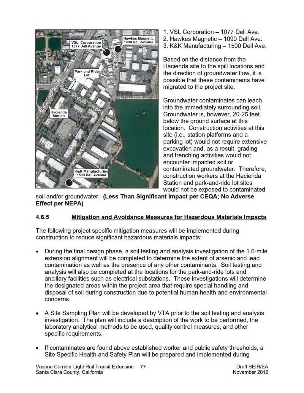
96
97 construction in accordance with 29 CFR (Hazardous Waste Operations and Emergency Response) to prevent hazardous materials exposure to workers and the public, control emissions of hazardous dust, and safeguard off-site transport of hazardous materials. During construction, remedial activities will be implemented including staking designated areas that were determined during the final design phase to have elevated levels of lead and/or arsenic, excavating those areas and stockpiling the soil, sampling of the stockpiles, and profiling the waste for landfill acceptance. Contaminated soils will be transported to an off-site Class I or Class II landfill, as appropriate. Transportation of contaminated soils will be by truck or railcar depending on the destination. The transport and disposal of hazardous materials will be in compliance with Federal, State, and local regulatory requirements, including the Uniform Hazardous Waste Manifest standards. If soil within a designated area is not excavated or handled, the material may remain in place as sub-base material with clean fill material placed above Conclusion Implementation of the identified mitigation measures would reduce hazardous materials impacts to construction workers, the public, and the environment to a less than significant level. Implementation of the proposed project would not result in any new hazardous materials impacts or impacts of greater severity than were identified in the Vasona Corridor Light Rail Transit Project Final EIS/EIR. (Less Than Significant Impact with Mitigation per CEQA; No Adverse Effect with Mitigation per NEPA) Vasona Corridor Light Rail Transit Extension 78 Draft SEIR/EA Santa Clara County, California November 2012
98 4.7 CULTURAL RESOURCES The following information is based on an Addendum Historic Properties Survey Report and Finding of Effect (HPSR/FOE) prepared by Basin Research Associates in November The purpose of the HPSR/FOE was to supplement the Vasona Light Rail Corridor Historic Properties Survey Report (June 1999) and identify cultural resources eligible for inclusion on the National Register of Historic Places (NRHP) and the California Register of Historic Resources (CRHR) within the Vasona Extension Area of Potential Effects (APE). In a letter to VTA dated April 25, 2011, the State Historic Preservation Officer (SHPO) concurred with the findings of the HPSR/FOE (see Appendix F) Regulatory Setting The National Historic Preservation Act of 1966, as amended, (NHPA) sets forth national policy and procedures regarding historic properties, defined as districts, sites, buildings, structures, and objects included in or eligible for the NRHP. Section 106 of NHPA requires federal agencies to take into account the effects of their undertakings on such properties and to allow the Advisory Council on Historic Preservation the opportunity to comment on those undertakings, following regulations issued by the Advisory Council on Historic Preservation (36 CFR 800). Historical resources are considered under CEQA, as well as California Public Resources Code Section , which established the CRHR Existing Setting The APE for archaeology and architecture for the proposed project is the southernmost 1.6 miles of the 6.8-mile long APE for the Vasona Light Rail Corridor plus additional areas to accommodate the design changes, including expanded parking at the existing Winchester Station/park-and-ride lot, the optional Hacienda park-and-ride lot, and the new location for the Vasona Junction park-and-ride lot. The APE extends along the railroad corridor from Kennedy Avenue near the existing Winchester Station south to SR 85 and encompasses properties on either side of the proposed project alignment (to the rear property line), as well as the locations of proposed stations and park-and-ride lots, and the Winchester Station platform which would be extended. Five existing station platforms (Campbell, Hamilton, Bascom, Fruitdale, and Race Street) are proposed to be extended. These areas are all within the original Vasona Corridor APE and with the exception of the Bascom Station are not included on the current APE. One property adjacent to the Bascom Station platform extension was reviewed and reevaluated for this project. Therefore, it was included on the APE for this project Archaeological Resources The 1999 HPSR concluded that there are no recorded archaeological sites, prehistoric or historic, in or adjacent to the APE that would be directly impacted by the Vasona Vasona Corridor Light Rail Transit Extension 79 Draft SEIR/EA Santa Clara County, California November 2012
99 Light Rail Corridor. The potential for disturbing as yet unknown prehistoric and historic site during construction is, however, considered to be moderate to high along Los Gatos Creek. Prehistoric The HPSR/FOE found that while the area in and around the APE is associated with the prehistoric occupation of Santa Clara Valley, no recorded prehistoric archaeological sites and/or cultural resources are located in or directly adjacent to the APE. Also, no recorded or known Native American archaeological sites, ethnographic settlements, or traditional Native American sites/use areas are located in or adjacent to the APE. Historic Spanish and Mexican Periods The HPSR/FOE identifies one historic resource in the APE from the Spanish and Mexican periods. In the late 1760s and 1770s, Spanish explorers were the first Europeans to pass through Santa Clara Valley. These expeditions lead to the establishment of Mission Santa Clara and the Pueblo San José de Guadalupe in One of the most notable explorers was Juan Bautista de Anza. The path of his expedition, the Juan Bautista de Anza National Historic Trail, is designed by the National Park Service as a National Historic Trail. The trail corridor crosses the southern end of the APE just north of SR Native American Consultation The Native American Heritage Commission (NAHC) was contacted concerning potential resources within the APE. The NAHC sacred lands search was negative for Native American resources in or adjacent to the project location. The nine individuals indentified by the NAHC as Native American contact for Santa Clara County were contracted by letter, , and/or telephone in No concerns or issues were identified by the Native American community during that consultation process Architectural Resources The 1999 HPSR identified 12 properties (8 in San José and 4 in Campbell) in the Vasona Light Rail Corridor APE as eligible for the NRHP. It was concluded that construction of the Vasona Light Rail Corridor would significantly impact 1 of these 12 resources. As mitigation, the resource (the Southern Pacific Depot/Cahill Station water tower in San José) was relocated on-site in accordance with The Secretary of the Interior s Standards for the Treatment of Historic Properties with Guidelines for Preserving, Rehabilitating, Restoring & Reconstructing Historic Buildings (U.S. Department of the Interior, National Park Service, 1995). No NRHP eligible resources were identified in the City of Campbell or Town of Los Gatos. 16 This trail corridor is not a brick and mortar facility that one walks or drives on. Rather, the trail corridor designation commemorates the approximate historic route that was followed by the de Anza expedition. Vasona Corridor Light Rail Transit Extension 80 Draft SEIR/EA Santa Clara County, California November 2012
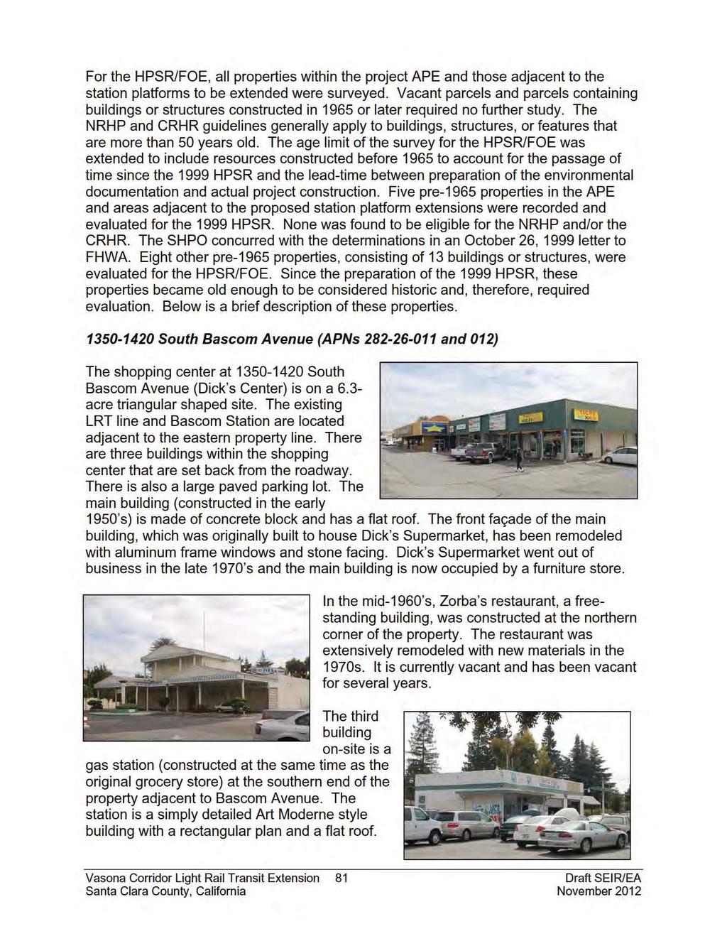
100
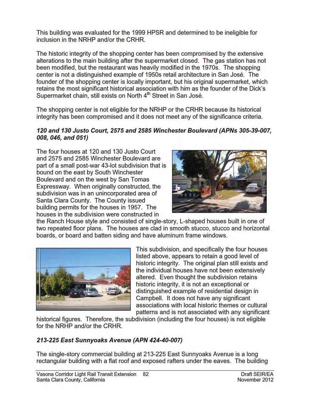
101
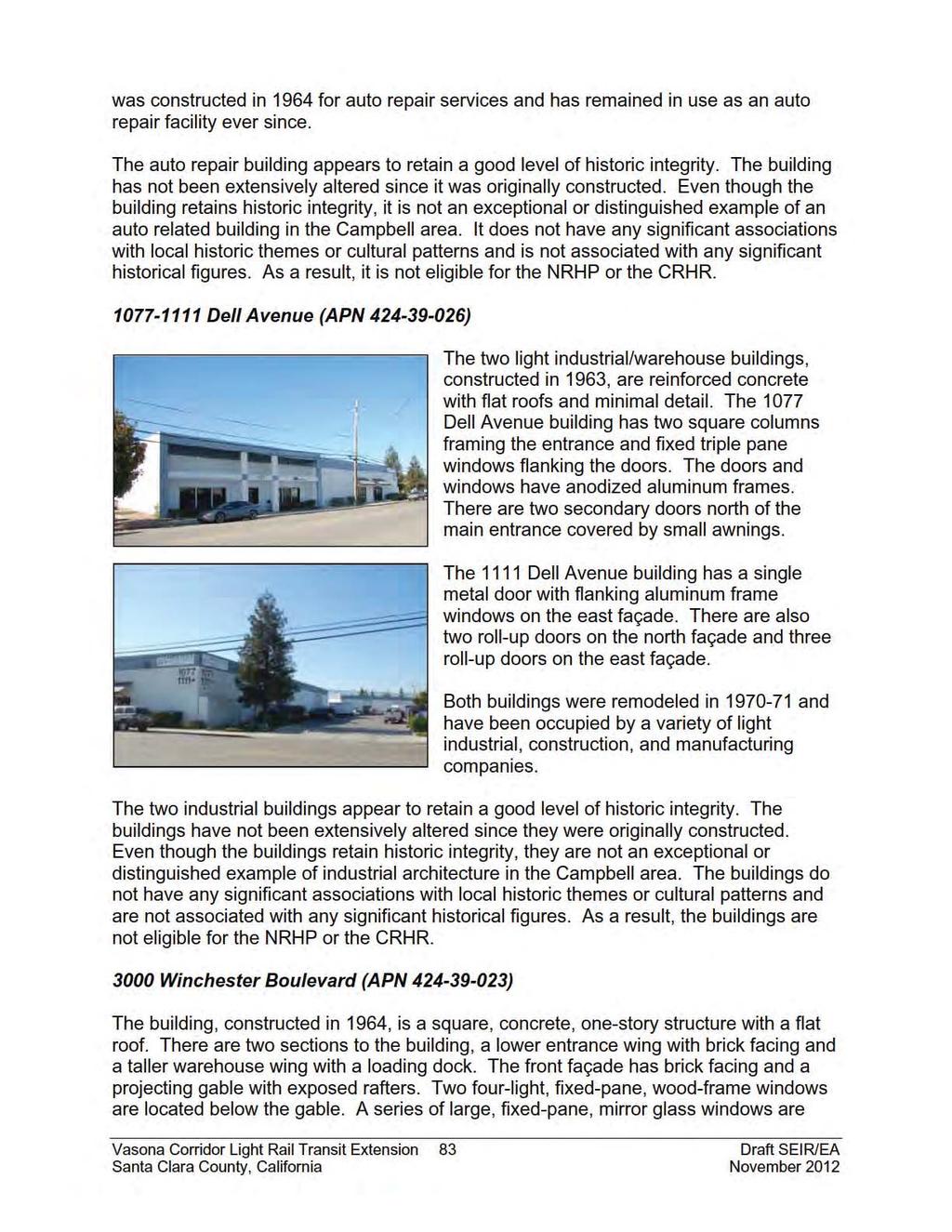
102
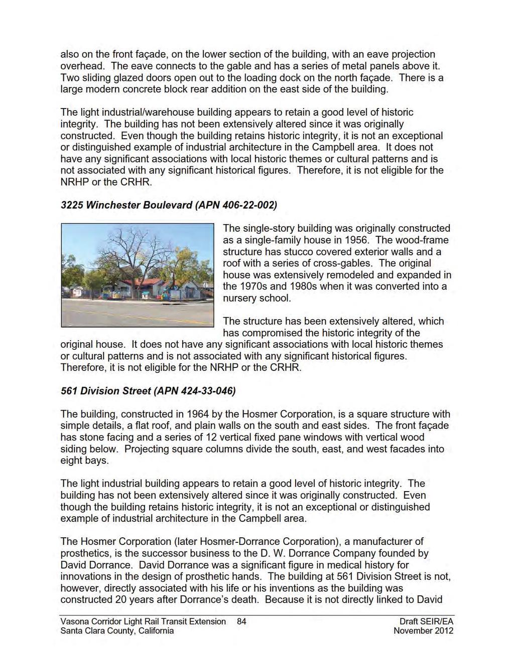
103
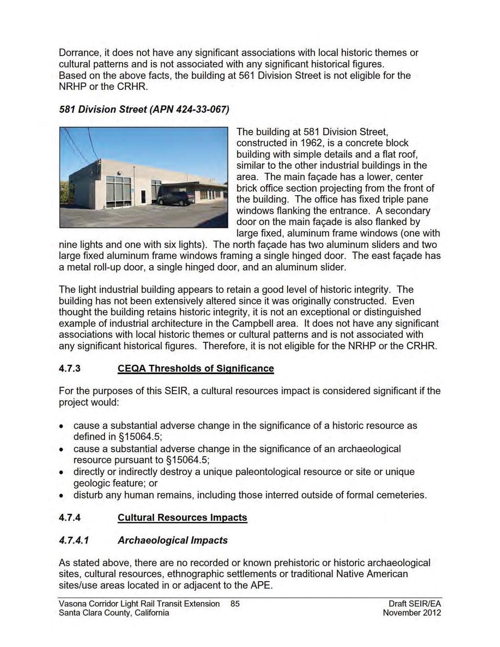
104
105 The 1999 HPSR, however, concluded that the possibility of disturbing as yet unknown prehistoric and historic sites during construction was moderate to high along Los Gatos Creek. While development on the Vasona Junction Station site has failed to generate reports of archaeological finding, the station site as well as the park-and-ride lot site has a moderate to high potential for containing prehistoric archaeological resources due to the close proximity of Los Gatos Creek. As a result, implementation of the proposed project could result in the discovery of previously unknown Native American artifacts and/or human remains. Impact CUL-1: Construction of the proposed Vasona Junction Station and park-andride lot could disturb previously unidentified cultural resources. (Significant Impact per CEQA; Adverse Effect per NEPA) The Juan Batista de Anza National Historic Trail crosses the southernmost end of the APE. The project would not, however, have any effect on the value for which the trail is listed as a historic resource. (Less Than Significant Impact per CEQA; No Adverse Effect per NEPA) Architectural Impacts Evaluation of the pre-1965 buildings within the APE determined that none of the subject properties is eligible for listing on either the NRHP and/or the CRHR. In a letter to VTA dated April 25, 2011, the SHPO concurred with these findings. Therefore, since no historic architectural resources are present within the APE, the project would have no effect on such resources. (No Impact per CEQA; No Effect per NEPA) Mitigation and Avoidance Measures for Cultural Resources Impacts To mitigate the significant impacts of the Vasona Corridor Light Rail Project, which included the Vasona extension, to a less than significant impact, the Memorandum of Agreement Between the Federal Transit Administration and the California State Historic Preservation Officer Regarding Development of the Vasona Light Rail Transit Project, Santa Clara County, California, was executed in June The Archaeological Resources Treatment and Monitoring Plan (ARTMP) was prepared in November The following project specific mitigation measures will be implemented during construction of the proposed project to reduce significant cultural resources impacts: Portions of the ARTMP that are applicable to the Vasona Junction Station and parkand-ride lot sites will be implemented, including the following: o A qualified archaeologist will be on-site to monitor the initial excavation of native soil once all pavement and engineered soil is removed from the Vasona Junction Station and park-and-ride lot sites. After monitoring the initial excavation, the archaeologist will make recommendations for further monitoring if it is determined that the site has cultural resources. If the archaeologist determines Vasona Corridor Light Rail Transit Extension 86 Draft SEIR/EA Santa Clara County, California November 2012
106 4.7.6 Conclusion that no resources are likely to be found on-site, no additional monitoring will be required. o In the event that prehistoric or historic resources are encountered during excavation and/or grading of the site, all activity within a 30- foot radius of the find will be stopped and the archaeologist will examine the find and make appropriate recommendations. Significant resources discovered during project construction will be evaluated and treated in accordance with the ARTMP. o In the event that human remains are discovered during excavation and/or grading of the site, the contractor will immediately secure and protect any remains and cultural materials. The Santa Clara County Coroner will be notified to make a determination as to whether the remains are of Native American origin or whether an investigation into the cause of death is required. If the remains are determined to be Native American, the Coroner will notify the Native American Heritage Commission (NAHC) immediately. Once NAHC identifies the most likely descendants, the descendants will make recommendations regarding proper burial, which will be implemented in accordance with Section (e) of the CEQA Guidelines. Implementation of the identified mitigation measures would reduce archaeological resources impacts to a less than significant level. The proposed project would not impact any historic structures. Implementation of the proposed project would not result in any new cultural resources impacts or impacts of greater severity than were identified in the Vasona Corridor Light Rail Transit Project Final EIS/EIR. (Less Than Significant Impact with Mitigation per CEQA; No Adverse Effect with Mitigation per NEPA) Vasona Corridor Light Rail Transit Extension 87 Draft SEIR/EA Santa Clara County, California November 2012
107 4.8 TRANSPORTATION AND CIRCULATION The following information is based on a transportation impact analysis (TIA) prepared by Hexagon Transportation Consultants, Inc. in March 2011 and an addendum to the TIA prepared in September 2011 (see Appendix G) Existing Setting Existing Roadway Network Regional access to the project area is provided via SR 85 and SR 17, which are described below. SR 85 is a six-lane freeway that extends from south San José to Mountain View. In the project area, SR 85 consists of two mixed-flow lanes and one high occupancy vehicle (HOV) lane in each direction. Interchanges with Bascom Avenue, SR 17, and Winchester Boulevard provide access to the project area. SR 17 is a four- to eight-lane freeway that extends from Santa Cruz to San José where it becomes Interstate 880 (I-880) to Oakland. SR 17 does not have HOV lanes in the project area. Interchanges with Lark Avenue and San Tomas Expressway provide access to the project area. Roadways that provide local access to the project area include Winchester Boulevard, San Tomas Expressway, Hacienda Avenue, and Lark Avenue. Winchester Boulevard is a four-lane roadway that extends from Santa Clara to Los Gatos. Winchester Boulevard provides direct access to the Winchester, Hacienda, and Vasona Junction Station sites. San Tomas Expressway is a six- to eight-lane expressway that extends from Santa Clara to Campbell. There is one HOV lane (restricted hours only) in each direction. San Tomas Expressway provides access to Winchester Boulevard and SR 17. Hacienda Avenue is a two-lane roadway that intersects Winchester Boulevard and terminates at Dell Avenue, immediately east of the Hacienda Station site. Hacienda Avenue provides direct access to the Hacienda Station and optional park-and-ride lot sites. Lark Avenue is a four- to six- lane roadway within the Town of Los Gatos. Lark Avenue provides access to Winchester Boulevard and SR 17. Vasona Corridor Light Rail Transit Extension 88 Draft SEIR/EA Santa Clara County, California November 2012
108 Existing Bicycle and Pedestrian Facilities Bike facilities in the project area include Class I and Class II bikeways. Class I refers to off-street bike paths that are shared with pedestrians. Class II refers to striped on-street bike lanes. South of SR 85, bike lanes are found on Winchester Boulevard between Lark Avenue and Blossom Hill Road. The Los Gatos Creek Trail, which runs generally parallel to the rail line, is considered an off-street bike path and extends from Meridian Avenue in San José to south of Los Gatos. The existing bicycle facilities in the project area are shown in Figure 19. Pedestrian facilities in the project area consist primarily of sidewalks and crosswalks along most streets in the residential and commercial areas. Due to the existing rail line, however, there is currently no sidewalk on the east side of Winchester Boulevard. Crosswalks with pedestrian signal heads are located at all of the signalized intersections in the project area Existing Transit Service The project area is served directly by several local and express bus routes that are operated by VTA. In addition, VTA s LRT system extends into the project area as far south as the Winchester Station. Both the buses and LRT provide connections to other regional transit systems, including Caltrain, Altamont Commuter Express, Capitol Corridor, and Amtrak. Transit services are shown in Table 5 below and on Figure 20. TABLE 5 Transit Line Bus 37 Bus 48 Bus 49 Bus 60 Bus 101 LRT Existing Transit Service Commute Hour Route Description Headways (in min) West Valley College to Capitol LRT Station via Winchester 30 Boulevard and Hacienda Avenue Los Gatos Civic Center to Winchester Transit Center via Winchester Boulevard, Hacienda Avenue, and Knowles 30 Drive Los Gatos Civic Center to Winchester Transit Center via 30 Camden Avenue, and Bascom/Los Gatos Boulevard, Winchester Transit Center to Old Ironsides and Tasman 15 Station via Winchester Boulevard Camden and SR 85 (San José) to Hansen and Page Mill N/A (Palo Alto) via Camden Avenue, Winchester Boulevard, (express route) and Hamilton Avenue Winchester Station (Campbell) to Mountain View via downtown San José, north San José, Santa Clara, and 15 Sunnyvale Source: VTA Santa Clara Valley Bus and Rail Map, January 2010 Vasona Corridor Light Rail Transit Extension 89 Draft SEIR/EA Santa Clara County, California November 2012
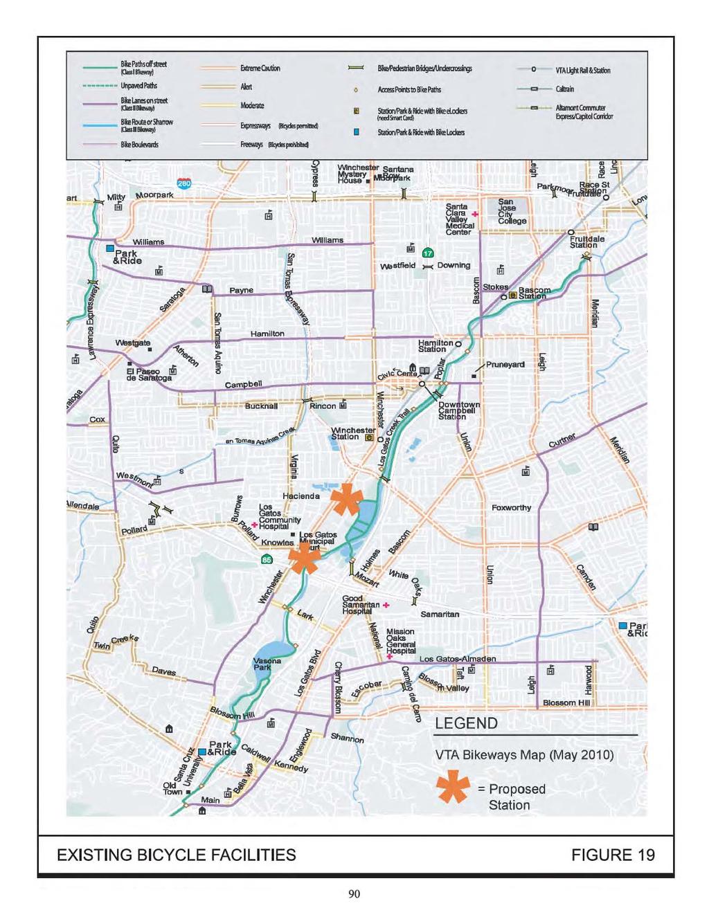
109
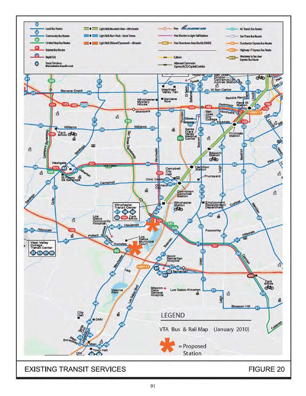
110
111 Existing Intersection Operations Methodology Traffic conditions at the signalized intersections within the vicinity of the project were evaluated using level of service (LOS), which is a qualitative description of operating conditions ranging from LOS A, or free-flowing conditions with little or no delay, to LOS F, or jammed conditions with excessive delays. The correlation between average delay and LOS is shown in Table 6. TABLE 6 Level of Service A B Signalized Intersection Level of Service Definitions Based On Delay Average Control Description Delay per Vehicle (in seconds) Operations with very low delay occurring with favorable 10.0 or less progression and/or short cycle lengths. Operations with low delay occurring with good progression and/or short cycle lengths to 20.0 C Operations with average delays resulting from fair progression and/or longer cycle lengths. Individual cycle 20.1 to 35.0 failures begin to appear. D Operations with longer delays due to a combination of unfavorable progression, long cycle lengths, or high volume to capacity ratios. Many vehicles stop and 35.1 to 55.0 individual cycle failures are noticeable. E Operations with high delay values indicating poor progression, long cycle lengths, and high V/C ratios. Individual cycle failures are frequent occurrences. This is 55.1 to 80.0 considered to be the limit of acceptable delay. F Operation with delays unacceptable to most drivers occurring due to over saturation, poor progression, or very long cycle lengths. Greater than 80.0 Source: Transportation Research Board, 2000 Highway Capacity Manual, (Washington, D.C., 2000) Existing Intersection Levels of Service The Santa Clara County s Congestion Management Program (CMP) LOS methodology is based on the Highway Capacity Manual (HCM) method for signalized intersections. The CMP considers intersection operations of LOS E or better during the peak hour to be acceptable. Weekday AM and PM peak hours of traffic are typically between 7:00 to 9:00 AM and 4:00 to 6:00 PM, respectively. It is during these periods that the most congested traffic conditions occur on an average day. Intersections were selected for study if project traffic would add at least 10 trips per lane per hour during one or more peak hours. This is consistent with the adopted CMP methodology. Vasona Corridor Light Rail Transit Extension 92 Draft SEIR/EA Santa Clara County, California November 2012
112 Analysis of the existing intersection operations concluded that all of the study intersections currently operate at an acceptable LOS D or better. The results of the existing conditions analysis are summarized in Table 7. Figure 21 shows the locations of the study intersections. TABLE 7 Existing Intersection Levels of Service No. Intersection Jurisdiction Peak Delay LOS Hour (in seconds) Winchester Boulevard and Budd AM 19.8 B 1 Campbell Avenue PM 19.7 B Winchester Boulevard and Winchester AM 4.8 A 2 Campbell Station PM 5.4 A Winchester Boulevard and Old AM 10.8 B 3 Campbell Camden Avenue PM 10.3 B Winchester Boulevard and Sunnyoaks AM 20.3 C 4 Campbell Avenue PM 13.8 B Winchester Boulevard and Hacienda AM 26.9 C 5 Campbell Avenue PM 28.5 C Winchester Boulevard and Knowles AM 35.3 D 6 Los Gatos Drive PM 49.9 D Winchester Boulevard and SR 85 AM 11.7 B 7 Los Gatos northbound ramps PM 15.6 B Winchester Boulevard and SR 85 AM 10.2 B 8 Los Gatos southbound ramps PM 7.2 A Winchester Boulevard and Wimbledon AM 11.8 B 9 Los Gatos Drive PM 12.2 B Winchester Boulevard and Lark AM 40.6 D 10 Los Gatos Avenue PM 29.8 C Source: Hexagon Transportation Consultants. Addendum to the Vasona Corridor LRT Extension Project Traffic Impact Analysis. September Freeway Operations Per CMP technical guidelines, a freeway segment LOS analysis is prepared for all segments to which a project is projected to add one percent or more to the segment capacity. For this project, the following freeway segments were analyzed: SR 17, between Los Gatos/Saratoga Road and Lark Avenue SR 17, between Lark Avenue and SR 85 SR 17, between SR 85 and Camden Avenue SR 17, between Camden Avenue and Hamilton Avenue SR 85, between Union Avenue and Bascom Avenue SR 85, between Bascom Avenue and SR 17 SR 85, between SR 17 and Winchester Boulevard SR 85, between Winchester Boulevard and Saratoga Avenue Vasona Corridor Light Rail Transit Extension 93 Draft SEIR/EA Santa Clara County, California November 2012
113
114 The assignment of station-generated traffic onto the surrounding roadway network shows that all station-generated traffic is anticipated to originate from within the adjacent neighborhoods and access the proposed stations via local roadways. Little or no station-generated traffic is anticipated to utilize freeway facilities to access the proposed station sites under either the 2011, 2015, or 2035 project scenarios. As a result, a freeway analysis for the CMP is not required CEQA Thresholds of Significance For the purposes of this SEIR, a transportation impact is considered significant if the project would: conflict with an applicable plan, ordinance or policy establishing measures of effectiveness for the performance of the circulation system, taking into account all modes of transportation including mass transit and non-motorized travel and relevant components of the circulation system, including but not limited to intersections, streets, highways and freeways, pedestrian bicycle paths, and mass transit; conflict with an applicable congestion management program, including, but not limited to level of service standards and travel demand measures, or other standards established by the county congestion management agency for designated roads or highways; result in a change in air traffic patterns, including either an increase in traffic levels or a change in location that results in substantial safety risks; substantially increase hazards due to a design feature (e.g., sharp curves or dangerous intersections) or incompatible uses (e.g., farm equipment); result in inadequate emergency access; or conflict with adopted policies, plans, or programs regarding public transit, bicycle, or pedestrian facilities, or otherwise decrease the performance or safety of such facilities. Based on CMP criteria, a project would cause a significant impact at a CMP intersection if the additional project traffic caused one of the following: Cause the level of service at any CMP/County intersection to degrade from an acceptable LOS E or better under existing or background conditions to an unacceptable LOS F under existing plus project or background plus project conditions; or At any CMP/County intersection that is already an unacceptable LOS F under existing or background conditions, cause the critical-movement delay at the intersection to increase by four or more seconds and the demand-to-capacity ratio (V/C) to increase by.01 or more. Vasona Corridor Light Rail Transit Extension 95 Draft SEIR/EA Santa Clara County, California November 2012
115 4.8.3 Transportation Impacts Overview The Vasona Corridor LRT Extension Project would be implemented in two phases, based on funding and projected ridership. Phase 1 would include all proposed improvements to the existing stations and the construction of the Vasona Junction Station/park-and-ride lot. Phase 2 would be construction of the Hacienda Station with or without the optional park-and-ride lot. It is assumed that Phase 1 would be operational by the year 2015 and that full build-out (Phases 1 and 2) would be completed by the year As discussed in Section 2.2, Phase 2A refers to full project build out without the optional Hacienda park-and-ride lot. Phase 2B refers to full project build-out with the optional Hacienda park-and-ride lot. The primary analysis is based on existing traffic conditions (2011). The comparison of the project to existing conditions answers the question how would the project change the existing transportation and traffic environment? It is a direct comparison to the current environment that uses existing facilities, volumes, and traffic patterns. No planned improvements and/or changes in traffic volumes due to planned growth are accounted for. Three scenarios were analyzed under the 2011 analysis: 1) existing plus Phase 1, 2) existing plus Phase 1 and Phase 2A, and 3) existing plus Phase 1 and Phase 2B. Because it is anticipated that the phases of the project would not be constructed until 2015 and 2035, this report also includes an analysis of the applicable phases of the proposed project for each of those horizon years. This analysis shows the effects of the project as compared to anticipated future conditions, such conditions represent changes that would occur with or without the project. This comparison is intended to disclose the complete or cumulative picture of the future transportation environment, taking into account traffic from future development planned for in the approved general plans of the cities of Santa Clara County. This comparison also accounts for planned growth in the region, as well as planned improvements to the transportation network. The methodology for each horizon year analysis is explained below with the analysis immediately following. It is important to note that the Vasona LRT project, unlike a commercial, industrial, or residential project, does not add or generate additional traffic to the roadway network. Instead, the project is intended to serve a portion of the projected traffic demand such demand that will exist with or without the LRT project. Serve, as used here, means that some of the trips that would otherwise be made by car will instead be made by transit, the net result being fewer cars on the roadway network. In transportation planning terms, this is referred to as mode shift, whereby someone switches from one mode (e.g., car) to a different mode (e.g., transit, bicycle, etc.). Therefore, in the following discussion, the phrase trip generation should not be construed to mean that new or additional vehicle trips will be made. Instead, the intent is to quantify the number of vehicles that will drive to/from a LRT station instead of Vasona Corridor Light Rail Transit Extension 96 Draft SEIR/EA Santa Clara County, California November 2012
116 making their entire trip by car. The purpose of this analysis is to determine if there is adequate capacity at the intersections located near the LRT stations to accommodate such trips Transportation Impacts Methodology Existing Conditions The traffic volumes estimated for the proposed project were added to existing traffic volumes to determine if an impact would occur if the proposed project were complete and operational today. No planned or pending roadway improvements are included in this analysis. The existing conditions analysis includes all phases of the proposed project. Because the park-and-ride lot at the Hacienda Station is optional, the existing conditions analysis covers three scenarios: Phase 1 Project (all features except Hacienda Station/park-and-ride lot) Phases 1 and 2A Project (Hacienda Station without park-and-ride lot) Phases 1 and 2B Project (Hacienda Station with park-and-ride lot) Trip generation for the proposed stations was estimated based on passenger projections obtained from the VTA traffic model Year 2011 Project Trip Generation Estimates The projections indicate that the highest passenger demand would occur in the AM peak hour. Although the PM demand would be less, to be conservative, the AM demand numbers were utilized in the analysis of the PM peak hour. Table 8 below shows the daily and peak hour trip generation estimates for all three scenarios in Year 2011 (existing conditions). Since the Phase 1 and Phase 1/2A project scenarios do not include a park-and-ride lot at the Hacienda Station, it is assumed that no trips would be generated by the Hacienda Station. Vasona Corridor Light Rail Transit Extension 97 Draft SEIR/EA Santa Clara County, California November 2012
117 TABLE 8 Year 2011 Project Trip Generation Estimates Mode of Phase 1 Phase 1 and 2A Phase 1 and 2B Access Daily AM PM Daily AM PM Daily AM PM Winchester Station Drop Off Park-and-Ride Total Hacienda Station Drop Off Park-and-Ride Total Vasona Junction Drop Off Park-and-Ride Total Source: Hexagon Transportation Consultants. Vasona Corridor LRT Extension Project Traffic Impact Analysis. March Year 2011 Intersection Levels of Service As shown in Table 9 below, the intersection LOS analysis concluded that all of the study intersections would operate at an acceptable LOS D or better under all scenarios in Therefore, the proposed project would have a less than significant transportation impact under existing conditions. (Less Than Significant Impact per CEQA; No Adverse Effect per NEPA) Vasona Corridor Light Rail Transit Extension 98 Draft SEIR/EA Santa Clara County, California November 2012
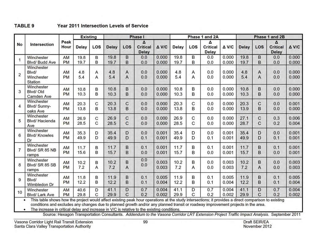
118
119 Year 2011 Countywide Transportation Network Performance The overall performance of the transportation network can be measured by vehicle miles traveled (VMT) and vehicles hours traveled (VHT). VMT is the total number of miles driven by all vehicles within a given time period and geographic area. VHT represents the total number of hours spent driving by all vehicles within a given time period and geographic area. Table 10 below shows the VMT and VHT projections for all scenarios in 2011 within Santa Clara County. TABLE 10 Year 2011 VMT/VHT Projections for Santa Clara County Scenario VMT VHT AM PM AM PM No Project 11,869,046 15,625, , ,569 Phase 1 Project 11,867,549 15,624, , ,530 Percent Change -0.01% -0.01% -0.01% -0.01% Phase 1 and 2A Project 11,867,177 15,623, , ,520 Percent Change -0.02% -0.01% -0.02% -0.01% Phase 1 and 2B Project 11,866,621 15,623, , ,506 Percent Change -0.02% -0.02% -0.02% -0.02% Source: Hexagon Transportation Consultants. Vasona Corridor LRT Extension Project Traffic Impact Analysis. March 2011 Phase 1 VTA projections show that implementation of the Phase 1 project in 2011 would reduce total VMT and VHT by 0.01 percent in the AM peak hour and 0.01 percent in the PM peak hour compared to the 2011 No Project condition. As a result, the proposed project would have a beneficial impact on the regional transportation network. (Beneficial Impact per CEQA; Beneficial Effect per NEPA) Phases 1 and 2A Projections show that implementation of Phases 1 and 2A would reduce total VMT and by 0.02 percent in the AM peak hour and 0.01 percent in the PM peak hour compared to the 2011 No Project condition. VHT would also be reduced by 0.02 percent in the AM peak hour and 0.01 percent in the PM peak hour compared to the 2011 No Project condition. As a result, the proposed project would have a beneficial impact on the regional transportation network under this project scenario. (Beneficial Impact per CEQA; Beneficial Effect per NEPA) Phases 1 and 2B Projections show that implementation of Phases 1 and 2B would reduce total VMT and VHT by 0.02 percent in the AM peak hour and 0.02 percent in the PM peak hour compared to the 2011 No Project condition. As a result, the proposed project would have a beneficial impact on the regional transportation network under this project scenario. (Beneficial Impact per CEQA; Beneficial Effect per NEPA) Vasona Corridor Light Rail Transit Extension 100 Draft SEIR/EA Santa Clara Valley Transportation Authority November 2012
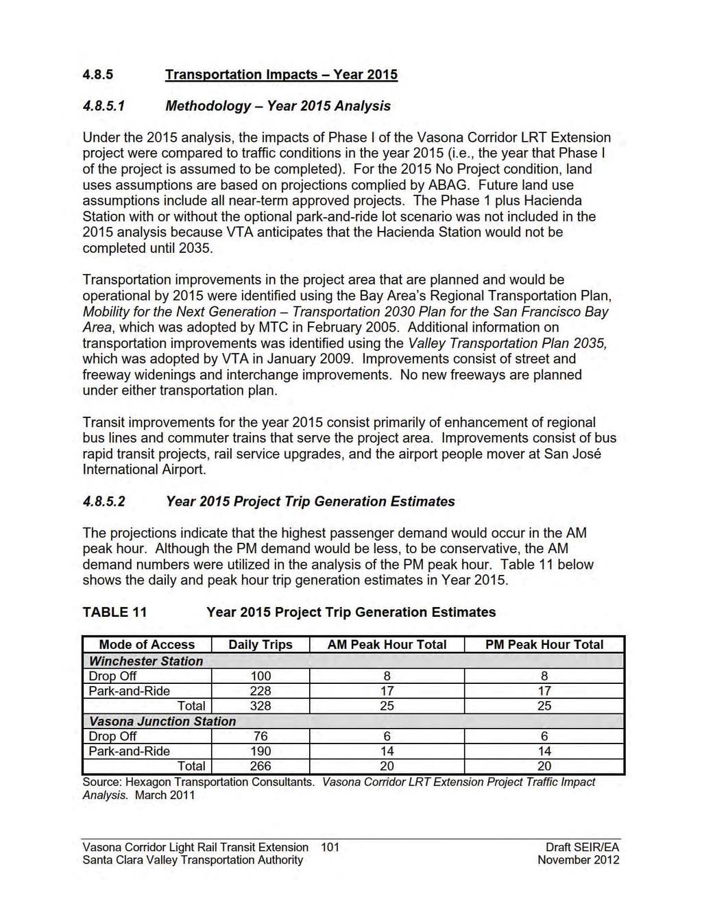
120
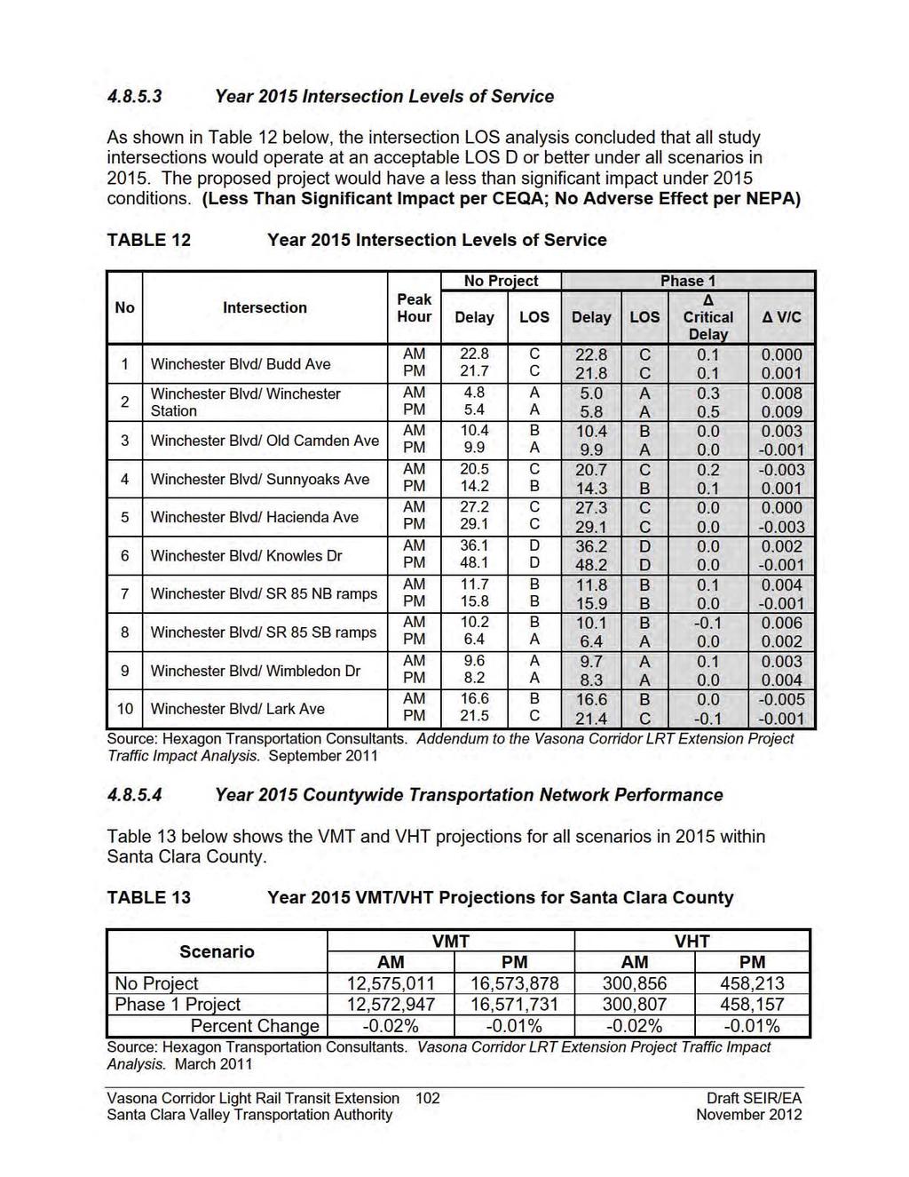
121
122 Projections show that implementation of the proposed Phase 1 project would reduce total VMT by 0.02 percent in the AM peak hour and 0.01 percent in the PM peak hour compared to the No Project condition. VHT would also be reduced by 0.02 percent in the AM peak hour and 0.01 percent in the PM peak hour compared to the No Project condition. As a result, the proposed project would have a beneficial impact on the regional transportation network under this project scenario. (Beneficial Impact per CEQA; Beneficial Effect per NEPA) Transportation Impacts Methodology Year 2035 Analysis As discussed in the project description, the 2035 project includes all improvements identified under the 2015 Phase 1 Project plus the construction of the Hacienda Station. Because the park-and-ride lot at the Hacienda Station is optional, the 2035 analysis covers three scenarios: Phase 1 Project (all features except Hacienda Station/park-and-ride lot) Phases 1 and 2A Project (Hacienda Station without park-and-ride lot) Phases 1 and 2B Project (Hacienda Station with park-and-ride lot) For the 2035 No Project condition, land use assumptions are based on projections complied by ABAG. Future land use assumptions include all near-term approved projects. Transportation improvements in the project area that are planned and would be operational by 2035 were identified using MTC s Regional Transportation Plan and the Valley Transportation Plan Improvements consist of street and freeway widenings and interchange improvements. No new freeways are planned under either transportation plan. Transit improvements for the year 2035 consist primarily of enhancement of regional bus lines and commuter trains that serve the project area. Improvements consist of bus rapid transit projects, rail service upgrades, and the airport people mover at San José International Airport Year 2035 Project Trip Generation Estimates The projections indicate that the highest passenger demand would occur in the AM peak hour. Although the PM demand would be less, to be conservative, the AM demand numbers were utilized in the analysis of the PM peak hour. Table 14 below shows the daily and peak hour trip generation estimates for all three scenarios in Year Since the Phase 1 and Phase 1/2A project scenarios do not include a park-andride lot at the Hacienda Station, it is assumed that no trips would be generated by the Hacienda Station. Vasona Corridor Light Rail Transit Extension 103 Draft SEIR/EA Santa Clara Valley Transportation Authority November 2012
123 TABLE 14 Year 2035 Project Trip Generation Estimates Mode of Phase 1 Phase 1 and 2A Phase 1 and 2B Access Daily AM PM Daily AM PM Daily AM PM Winchester Station Drop Off Park-and-Ride Total Hacienda Station Drop Off Park-and-Ride Total Vasona Junction Drop Off Park-and-Ride Total Source: Hexagon Transportation Consultants. Vasona Corridor LRT Extension Project Traffic Impact Analysis. March Year 2035 Intersection Levels of Service The intersection LOS analysis concluded that all but one of the study intersections, Winchester Boulevard and Knowles Drive, would operate at an acceptable LOS D or better under all scenarios in The Winchester Boulevard/Knowles Drive intersection would operate at LOS E in the PM peak hour. The results of the 2035 analysis are summarized in Table 15 below. (Less Than Significant Impact per CEQA; No Adverse Effect per NEPA) Vasona Corridor Light Rail Transit Extension 104 Draft SEIR/EA Santa Clara Valley Transportation Authority November 2012
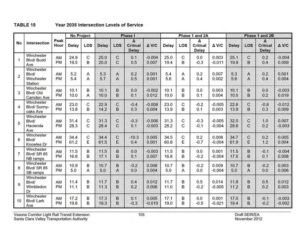
124
125 Year 2035 Countywide Transportation Network Performance Table 16 below shows the VMT and VHT projections for all scenarios in 2035 within Santa Clara County. TABLE 16 Year 2035 VMT/VHT Projections for Santa Clara County Scenario VMT VHT AM PM AM PM No Project 15,559,874 20,963, , ,732 Phase 1 Project 15,557,125 20,960, , ,642 Percent Change -0.02% -0.01% -0.02% -0.01% Phase 1 and 2A Project 15,556,302 20,959, , ,611 Percent Change -0.02% -0.02% -0.02% -0.01% Phase 1 and 2B Project 15,555,535 20,958, , ,585 Percent Change -0.03% -0.02% -0.03% -0.02% Source: Hexagon Transportation Consultants. Vasona Corridor LRT Extension Project Traffic Impact Analysis. March 2011 Phase 1 Projections show that implementation of the Phase 1 project would reduce total VMT by 0.02 percent in the AM peak hour and 0.01 percent in the PM peak hour compared to the 2035 No Project condition. VHT would also be reduced by 0.02 percent in the AM peak hour and 0.01 percent in the PM peak hour compared to the 2035 No Project condition. As a result, the proposed project would have a beneficial impact on the regional transportation network under this project scenario. (Beneficial Impact per CEQA; Beneficial Effect per NEPA) Phases 1 and 2A Projections show that implementation of Phases 1 and 2A would reduce total VMT by 0.02 percent in the AM and PM peak hour compared to the 2035 No Project condition. VHT would be reduced by 0.02 percent in the AM peak hour and 0.01 percent in the PM peak hour compared to the 2035 No Project condition. As a result, the proposed project would have a beneficial impact on the regional transportation network under this project scenario. (Beneficial Impact per CEQA; Beneficial Effect per NEPA) Phases 1 and 2B Projections show that implementation of Phases 1 and 2B would reduce total VMT and VHT by 0.03 percent in the AM peak hour and 0.02 percent in the PM peak hour compared to the 2035 No Project condition. As a result, the proposed project would have a beneficial impact on the regional transportation network under this project scenario. (Beneficial Impact per CEQA; Beneficial Effect per NEPA) Vasona Corridor Light Rail Transit Extension 106 Draft SEIR/EA Santa Clara Valley Transportation Authority November 2012
126 4.8.7 Pedestrian and Bicycle Impacts Bike lanes are currently located on Winchester Boulevard between Lark Avenue and Blossom Hill Road. The Los Gatos Creek Trail runs generally parallel to the rail line and extends from Meridian Avenue in San José to south of Los Gatos. Implementation of the proposed project would not modify, remove, or impede the existing bicycle facilities in the project area. (No Impact per CEQA; No Effect per NEPA) Pedestrian facilities in the project area consist primarily of sidewalks and crosswalks along most streets in the residential and commercial areas. Implementation of the proposed project would not modify, remove, or impede the existing pedestrian facilities in the project area. Existing pedestrian facilities would be sufficient to provide safe access between the proposed Hacienda Station and optional park-and-ride lot as well as the proposed Vasona Junction Station and park-and-ride lot. Both the Hacienda Station and Vasona Junction Station would be located adjacent to signalized intersections with crosswalks that provide safe pedestrian access from the west side of Winchester Boulevard. As part of the project, an at-grade pedestrian crossing would be constructed at the Winchester Station to facilitate safe access to the LRT from the adjacent Avalon Campbell Apartments. In addition, a pedestrian/bicycle connection would be constructed between the Vasona Junction Station park-and-ride lot and the Los Gatos Creek Trail. (No Impact per CEQA; No Effect per NEPA) Parking Impacts Loss of Parking at Vasona Technology Park Construction of the Hacienda Station and relocation of the freight tracks would require the acquisition of ROW along the western property line of the Vasona Technology Park site. Approximately 80 existing parking spaces would be removed as a result. The area between the new property line and the building would be designated as a one-way drive aisle and restriped to accommodate approximately 35 parking spaces. Therefore, the ROW acquisition would result in a net loss of approximately 45 parking spaces. Vasona Technology Park has 311,645 square feet of office/industrial space and 1,051 surface parking spaces. Currently, approximately 15 percent of the building space is vacant. A parking utilization survey was completed by Hexagon Transportation Consultants over a three-day period to determine if the loss of 45 parking spaces would impact business operations. The survey determined that the highest peak parking demand over the three-day period was 564 spaces or approximately 54 percent of the total available parking. Implementation of the project would reduce the total available parking to 1,006 spaces. Adjusting the peak parking demand upward to account for current building vacancies, the estimated peak parking demand would be approximately 668 spaces. Even with the loss of 45 parking spaces, there would be a surplus of approximately 338 parking spaces during peak demand. Therefore, the loss of 45 parking spaces along the western property line of Vasona Technology Park would not Vasona Corridor Light Rail Transit Extension 107 Draft SEIR/EA Santa Clara Valley Transportation Authority November 2012
127 interfere with business operations or result in significant operational issues or loss of business. (Less Than Significant Impact per CEQA; No Adverse Effect per NEPA) Loss of Parking at Netflix Construction of the Vasona Junction Station, including the relocation of the existing freight track, would require the acquisition of additional ROW from a portion of the adjacent Netflix property that abuts Winchester Boulevard. The additional ROW would result in the loss of approximately 50 surface parking spaces at the westerly edge of the Netflix parcel. There are approximately 450 existing parking spaces that are designated for Netflix, of which approximately 350 are located in a basement-level parking garage and 100 are surface parking adjacent to the north and west sides of the Netflix buildings. In addition, there are approximately 90 additional surface parking spaces on the east side of the Netflix buildings that are shared between Netflix and the adjacent Aventino Apartments. Based on information provided by Netflix 17, the underground, secure garage is intended for employee parking, with guest parking available in the surface lot. Pavement markings on 28 of the surface spaces indicate guest parking only. Based on information provided by Netflix, many of the surface parking spaces designated for visitors are being used by employees in lieu of parking in the garage. According to Netflix, they currently have 525 employees at this site. Based on a parking utilization survey completed by VTA during normal business hours, existing usage on the site is as follows: Garage Parking Utilization: approximately 25 percent (approximately 87 spaces occupied out of 350 spaces) Surface Parking Utilization: approximately 52 percent (approximately 99 spaces occupied out of 190 spaces) Total Parking Utilization: approximately 34 percent (approximately 186 spaces occupied out of 540 spaces) If 525 employees plus guests are currently utilizing approximately 34 percent of the parking, then, assuming full capacity at the site (i.e., 650 employees, according to Netflix), with a proportionate increase in parking, total parking utilization would increase to approximately 42 percent (i.e., 227 spaces out of the 540 total would be utilized). Factoring in a loss of 50 parking spaces due to the project, there would be sufficient parking to accommodate the full complement of 650 employees and visitors based on existing and anticipated utilization of parking. Although the majority of parking spaces that are designated for guest parking are the ones to be impacted by the project, the remaining surface spaces would accommodate visitors if employees are directed to use the existing garage. Directing employees to use the garage may be accomplished by providing signage or additional pavement markings indicating that the surface spaces 17 Jim Leibold, Netflix Facilities Project Manager (February 2010), Vasona Corridor Light Rail Transit Extension 108 Draft SEIR/EA Santa Clara Valley Transportation Authority November 2012
128 are designated as visitor parking only. Also see Section , Impacts to Businesses and Residences. The parking area identified for acquisition is also utilized for shipping and receiving at Netflix. While the parking spaces along the western property line would be removed, the existing drive isle and the parking spaces along the building frontage would remain. Therefore, the loss of the parking spaces would not preclude trucks from utilizing this area for shipping and receiving operations. Based on the above analysis, the loss of approximately 50 parking spaces along the western property line of the Netflix site would not interfere with business operations or result in significant operational issues or loss of business. (Less Than Significant Impact per CEQA; No Adverse Effect per NEPA) Mitigation and Avoidance Measures for Transportation Impacts No mitigation is required or proposed Conclusion The proposed project would have a less than significant impact on the LOS of local intersections during all horizon years and under all project scenarios. (Less Than Significant Impact per CEQA; No Adverse Effect per NEPA) The proposed project would have a beneficial impact on countywide transportation network performance during all horizon years and under all project scenarios. (Beneficial Impact per CEQA; Beneficial Effect per NEPA) The proposed project would have no impact on pedestrian and bicycle facilities during all horizon years and under all project scenarios. (No Impact per CEQA; No Effect per NEPA) Vasona Corridor Light Rail Transit Extension 109 Draft SEIR/EA Santa Clara Valley Transportation Authority November 2012
129 4.9 AIR QUALITY This section is primarily based upon an air quality analysis prepared by Terry A. Hayes Associates, Inc., in December 2010 (see Appendix H) Regulatory Setting Federal, State, and Local Air Quality Regulations The significance of a pollutant concentration is determined by comparing the pollutant levels to an appropriate ambient air quality standard. The standards set the level of pollutant concentrations allowable while protecting general public health and welfare. The Federal Clean Air Act (Federal CAA) establishes pollutant thresholds for air quality in the United States. In addition to being subject to Federal requirements, California has its own more stringent regulations under the California Clean Air Act (California CAA). At the Federal level, the EPA administers the CAA. The California CAA is administered by the California Air Resources Board (CARB) at the State level and by the Air Quality Management District s at the regional and local levels. BAAQMD regulates air quality in the nine-county Bay Area. EPA is responsible for establishing the National Ambient Air Quality Standards (NAAQS), which are required under the Federal CAA. The EPA regulates emission sources that are under the exclusive authority of the federal government, such as aircraft, ships, and certain types of locomotives. The agency also establishes various emission standards for vehicles sold in states other than California. Automobiles sold in California must meet the stricter emission standards established by CARB. California Air Resources Board CARB is responsible for meeting the State requirements of the Federal CAA, administering the California CAA, and establishing the California Ambient Air Quality Standards (CAAQS). The California CAA requires all air districts in the State to achieve and maintain the CAAQS. CARB regulates mobile air pollution sources such as motor vehicles. The agency is responsible for setting emission standards for vehicles sold in California and for other emission sources, such as consumer products and certain offroad equipment. CARB has established passenger vehicle fuel specifications and oversees the functions of local air pollution control districts and air quality management districts, which in turn administer air quality activities at the regional and county level. CARB also conducts or supports research into the effects of air pollution on the public and develops approaches to reduce air pollutant emissions. Bay Area Air Quality Management District BAAQMD is primarily responsible for ensuring that the National and State ambient air quality standards are attained and maintained in the Bay Area. These ambient air Vasona Corridor Light Rail Transit Extension 110 Draft SEIR/EA Santa Clara Valley Transportation Authority November 2012
130 quality standards are levels of contaminants that represent safe levels that avoid specific adverse health effects associated with each pollutant. The ambient air quality standards cover what are called criteria pollutants. Table 17 identifies the major criteria pollutants, characteristics, health effects, and typical sources for the Bay Area. TABLE 17 Major Criteria Pollutants Pollutant Characteristics Health Effects Major Sources Major sources of ozone A highly reactive precursors are photochemical pollutant Eye irritation combustion sources created by the action of Ozone such as factories and sun light on ozone Respiratory function automobiles, and precursors. Often called impairment evaporation of solvents photochemical smog. and fuels. Impairment of oxygen transport in the bloodstream Carbon Monoxide An odorless, colorless gas that is highly toxic. It is formed by the incomplete combustion of fuels. Aggravation of cardiovascular disease Fatigue, headache, confusion, dizziness Automobile exhaust, combustion of fuels, combustion of wood in wood stoves and fireplaces. Nitrogen Dioxide Sulfur Dioxide Particulate Matter Reddish-brown gas that discolors the air, formed during combustion. A colorless gas with a pungent, irritating odor. Solid and liquid particles of dust, soot, aerosols, and other matter that are small enough to remain suspended in the air for a long period of time. Can be fatal in very high concentrations Increased risk of acute and chronic respiratory disease Aggravation of chronic obstruction lung disease Increased risk of acute and chronic respiratory disease Aggravation of chronic disease and heart/lung disease symptoms Automobile and diesel truck exhaust, industrial processes, and fossilfueled power plants. Diesel vehicle exhaust, oil-powered power plants, and industrial processes. Combustion, automobiles, field burning, factories and unpaved roads. Also a result of photochemical processes National and State Ambient Air Quality Standards The ambient air quality in a given area depends on the quantities of pollutants emitted within the area, transport of pollutants to and from the surrounding areas, local and regional meteorological conditions, and the surrounding topography of the air basin. Air quality is described by the concentration of various pollutants in the atmosphere. The Vasona Corridor Light Rail Transit Extension 111 Draft SEIR/EA Santa Clara Valley Transportation Authority November 2012
131 significance of the pollutant concentration is determined by comparing the concentration to an appropriate ambient air quality standard. The standards represent the allowable pollutant concentrations designed to ensure that the public health and welfare are protected, while including a reasonable margin of safety to protect the more sensitive individuals in the population. As required by the Federal CAA, the NAAQS have been established for six major air pollutants; carbon monoxide (CO), nitrogen dioxide (NO 2 ), ozone (O 3 ), respirable particulate matter (PM 10 ), fine particulate matter (PM 2.5 ), and sulfur dioxide (SO 2). Pursuant to the California CAA, the State of California has also established ambient air quality standards. The CAAQS are generally more stringent than the corresponding Federal standards. Both State and Federal standards are summarized in Table 18. Units of concentration are expressed in parts per million (ppm) or micrograms per kilogram (µg/m 3 ). The primary standards have been established to protect the public health. The secondary standards are intended to protect the nation s welfare and account for adverse air pollutant effects on soil, water, visibility, materials, vegetation and other aspects of the general welfare. Because CAAQS are generally more stringent than NAAQS, CAAQS are used as the comparative standard in this analysis. TABLE 18 Federal and State Ambient Air Quality Standards Pollutant Ozone Carbon monoxide Nitrogen dioxide Averaging California National Standards National Standards Time Standards Primary Secondary 1-hour 0.09 ppm --- Same as primary 8-hour 0.07 ppm ppm hour 20 ppm 35 ppm hour 9.0 ppm 9.0 ppm hour 0.18 ppm 0.10 ppm --- Annual 0.03 ppm ppm Same as primary 1-hour 0.25 ppm ppm --- Sulfur 3-hour ppm dioxide 24-hour 0.04 ppm hour 50 g/m g/m 3 Same as primary PM 10 Annual 20 g/m PM hour g/m 3 Same as primary Annual 12 g/m 3 15 g/m 3 Same as primary Source: California Air Resources Board, September Toxic Air Contaminant Regulations Toxic air contaminants (TACs), also referred to as hazardous air pollutants (HAPs) under the Federal CAA, are pollutants that can result in an increase in serious illness or death in humans. Health effects of TACs may include cancer, birth defects, and immune system and neurological damage. TACs are classified as carcinogens and noncarcinogens based on the effects of exposure. For regulatory purposes, there is no safe exposure threshold for carcinogens. There are, however, safe exposure thresholds for noncarcinogens that are determined on a pollutant-by-pollutant basis. TACs are not criteria pollutants and are, therefore, regulated differently than other air Vasona Corridor Light Rail Transit Extension 112 Draft SEIR/EA Santa Clara Valley Transportation Authority November 2012
132 pollutants. The EPA and CARB regulate HAPs and TACs through statues and regulations that generally require the use of the maximum or best available control technology (MACT and BACT) to limit emissions. These statues and regulations, in conjunction with additional rules set forth by BAAQMD, establish the regulatory framework for TACs in the Bay Area Existing Setting Air quality is determined by the concentration of various pollutants in the atmosphere. Units of concentration are expressed in parts per million (ppm) or micrograms per kilogram (g/m 3 ). The amount of a given pollutant in the atmosphere is determined by the amount of pollutants released within an area, transport of pollutants to and from surrounding areas, local and regional meteorological conditions, and the surrounding topography of the air basin. The major determinants of transport and dilution are wind, atmosphere stability, terrain, and for photochemical pollutants, sunlight. San José, Campbell, and Los Gatos are located in the southern portion of the San Francisco Bay Area Air Basin. The proximity of this area to both the Pacific Ocean and San Francisco Bay has a moderating influence on the climate. Northwest winds and northerly winds are most common in the project area, reflecting the orientation of the Bay and the San Francisco Peninsula. Winds from these directions carry pollutants released by autos and factories from upwind areas of the Peninsula toward the South Bay, particularly during the summer months. Winds are lightest, on average, in the fall and winter. Every year in fall and winter there are periods of several days when winds are very light and local pollutants can build up. Air quality standards for ozone are typically exceeded when relatively stagnant conditions occur for periods of several days during the warmer months of the year. Significant ozone formation occur during the months from late spring through early fall. Prevailing winds during the summer and fall can transport and trap ozone precursors from the more urbanized portions of the Bay Area. Meteorological factors make air pollution potential in Santa Clara Valley quite high. Pollutants can be diluted by mixing in the atmosphere both vertically and horizontally. Vertical mixing and dilution of pollutants are often suppressed by inversion conditions, when a warm layer of air traps cooler air close to the surface. During the summer, inversions are generally elevated above ground level, but are present over 90 percent of the time in both the morning and afternoon. In winter, surface-based inversions dominate in the morning hours, but frequently dissipate by afternoon. Topography can restrict horizontal dilution and mixing of pollutants by creating a barrier to air movement. The South Bay has significant terrain features that affect air quality. The Santa Cruz Mountains and Diablo Range on either side of the South Bay restrict horizontal dilution, and this alignment of the terrain channels winds from the north to south, carrying pollution from the northern Peninsula toward the project area. The combined effects of moderate ventilation, frequent inversions that restrict vertical dilution and terrain that restricts horizontal dilution give the project area a relatively high Vasona Corridor Light Rail Transit Extension 113 Draft SEIR/EA Santa Clara Valley Transportation Authority November 2012
133 atmospheric potential for pollution compared to other parts of the San Francisco Bay Air Basin and provide a high potential for transport of pollutants to the east and south Air Monitoring Data Air quality in the region is controlled by the rate of pollutant emissions and meteorological conditions. Meteorological conditions, such as wind speed, atmospheric stability, and mixing height may all affect the atmosphere s ability to mix and disperse pollutants. Long-term variations in air quality typically result from changes in air pollutant emissions, while frequent, short-term variations result from changes in atmospheric conditions. The San Francisco Bay Area is considered one of the cleanest metropolitan areas in the country with respect to air quality. BAAQMD monitors air quality conditions at 23 locations throughout the San Francisco Bay Air Basin. The monitoring site closest to the project alignment is the Los Gatos Monitoring Station, which only measures ozone. The San José Jackson Street Monitoring Station is the second nearest station which monitors the remaining criteria pollutants including CO, sulfur dioxide, particulate matter (PM 2.5 and PM 10 ), and nitrogen dioxide. Table19 below lists the number of State and/or Federal standards violations recorded at the San José and Los Gatos monitoring stations from 2008 to 2010 (the most current years that data is available). Violations during the time period include ozone, PM 10, and PM 2.5. Vasona Corridor Light Rail Transit Extension 114 Draft SEIR/EA Santa Clara Valley Transportation Authority November 2012
134 TABLE 19 Number of Ambient Air Quality Standards Violations ( ) Pollutant Standard Days Exceeded Days Exceeded Days Exceeded Ozone Federal 8-hour Ozone State 8-hour Ozone State 1-hour Carbon Monoxide Federal 8-hour Carbon Monoxide State 8-hour Carbon Monoxide Federal 1-hour Carbon Monoxide State 1-hour Nitrogen Dioxide Federal 1-hour Nitrogen State 1-hour Dioxide PM10 Federal 24-hour PM10 State 24-hour PM2.5 Federal 24-hour Sulfur Dioxide 18 State 24-hour n/a 0 0 Sulfur Dioxide Federal 24-hour n/a Attainment Status Source: BAAQMD, Bay Area Air Pollution Summary The pollutants known to exceed the State and Federal standards in the project area are regional pollutants. Ozone, PM 10, and PM 2.5 are all considered regional pollutants because the concentrations are not determined by proximity to individual sources, but show a relative uniformity over a region. The Federal CAA and the California CAA of 1988 require that the CARB, based on air quality monitoring data, designate portions of the State where Federal or State ambient air quality standards are not met as nonattainment areas. Because of the differences between the Federal and State standards, the designation of nonattainment area is different under the Federal and State legislation. Under the California CAA, Santa Clara County is a nonattainment area for ozone and PM 10. The County is either in attainment or unclassified for other pollutants. Under the Federal CAA, the entire Bay Area region is classified as nonattainment for the 24-hour PM 2.5 standard. The EPA grades the region as in attainment or unclassified for all other air pollutants, including PM Sulfur dioxide monitoring was not available at the San José monitoring station until Vasona Corridor Light Rail Transit Extension 115 Draft SEIR/EA Santa Clara Valley Transportation Authority November 2012
135 Sensitive Receptors There are groups of people more affected by air pollution than others. CARB has identified children under 14, the elderly (over 65), athletes, and people with cardiovascular and chronic respiratory diseases as people most likely to be affected by air pollution. These groups are classified as sensitive receptors. Locations that may contain a high concentration of sensitive population groups include residential areas, hospitals, day care facilities, elder care facilities, elementary schools, and parks. The closest sensitive receptors to the proposed project alignment are the residences and a day care center on the west side of Winchester Boulevard and the Aventino Apartments adjacent to the proposed Vasona Junction park-and-ride lot. There is also an elementary school, preschool, and residential care home within the project area. The nearest residents are located approximately 100 feet west of the rail alignment ROW CEQA Thresholds of Significance For the purposes of this SEIR, an air quality impact is considered significant if the project would: Conflict with or obstruct implementation of the applicable air quality plan; Violate any air quality standard or contribute substantially to an existing or projected air quality violation; Result in a cumulatively considerable net increase of any criteria pollutant for which the project region is classified as non-attainment under an applicable Federal or State ambient air quality standard (including releasing emissions that exceed quantitative thresholds for ozone precursors; Expose sensitive receptors to substantial pollutant concentrations; or Create objectionable odors affecting a substantial number of people Air Quality Impacts As discussed in CEQA Guidelines Section 15064(b), the determination of whether a project may have a significant effect on the environment calls for careful judgment on the part of the lead agency and must be based to the extent possible on scientific and factual data. VTA and other lead agencies in the San Francisco Bay Area Air Basin, often utilize the thresholds and methodology for assessing air emissions and/or health effects adopted by BAAQMD based upon the scientific and other factual data prepared by BAAQMD in developing those thresholds. In December 2010, the California Building Industry Association (BIA) filed a lawsuit in Alameda County Superior Court challenging toxic air contaminants and PM2.5 thresholds adopted by BAAQMD in its CEQA Air Quality Guidelines (California Building Industry Association v. Bay Area Air Quality Management District, Alameda County Superior Court Case No. RG ). One of the identified concerns is inhibiting infill and smart growth in the urbanized Bay Area. On March 5, 2012, the Superior Court found that the adoption of thresholds by the BAAQMD in its CEQA Air Quality Guidelines is a CEQA project and BAAQMD is not to disseminate officially sanctioned air quality thresholds of significance until BAAQMD fully complies with CEQA. No Vasona Corridor Light Rail Transit Extension 116 Draft SEIR/EA Santa Clara Valley Transportation Authority November 2012
136 further findings or rulings on the thresholds in the BAAQMD CEQA Air Quality Guidelines were made. At the time of publication of the Draft EIR, BAAQMD has determined that Lead Agencies may rely of the BAAQMD CEQA Guidelines (May 2011) for assistance in calculating air pollutant emission but they no longer recommend using the thresholds as a general measure of the project s significant air quality impacts. VTA understands the effect of the lawsuit to be that BAAQMD may eventually have to prepare an environmental review document before adopting the same or revised thresholds. The ruling, however, in the case does not equate to a finding that the quantitative metrics in the BAAQMD thresholds are incorrect or unreliable for meeting goals in the Bay Area 2010 Clean Air Plan. Moreover, as noted above, the determination of whether a project may have a significant effect on the environment is subject to the discretion of each lead agency, based upon substantial evidence. Notwithstanding the BIA lawsuit, which has no binding or preclusive effect on VTA s discretion to decide on the appropriate thresholds to use for determining the significance of air quality impacts, VTA has carefully considered the thresholds prepared by BAAQMD and regards the thresholds listed below to be based on the best information available for the San Francisco Bay Area Air Basin and conservative in terms of the assessment of health effects associated with TACs and PM 2.5. The analysis in this SEIR/EA is based upon the methodologies and thresholds in the BAAQMD CEQA Air Quality Guidelines Operational Project Emissions Operational emissions were analyzed for 2015 (Phase 1 completion) and 2035 (Phase 2 completion). Regional emissions were based on total VMT with and without implementation of the proposed project. Automobile emissions associated with VMT within Santa Clara County were calculated using light-duty emission factors obtained from the CARB EMFAC2007 Motor Vehicle Emissions Inventory Model. Localized emissions were calculated using the EPA ISCST3 dispersion model and included emissions from automobiles and buses driving into the park-and-ride lots as well as idling emissions associated with buses waiting for passengers. Table 20 below lists the VMT under the various analysis scenarios. TABLE 20 Comparison of Countywide Daily Vehicle Miles Traveled With and Without the Project Scenario VMT Change from No Project Scenario 2015 No Project 125,750, with Phase 1 Project 125,729, % 2035 No Project 155,598, with Phases 1 and 2B Project 155,555, % *These numbers represent the percentage change from the No Project scenario in the same horizon year. Note: VMT was calculated by multiplying the AM Peak VMT by 10. Source: Hexagon Transportation Consultants. Vasona Corridor LRT Extension Project Traffic Impact Analysis. March 2011 Vasona Corridor Light Rail Transit Extension 117 Draft SEIR/EA Santa Clara Valley Transportation Authority November 2012
137 Countywide Emissions The emission rates, in combination with the VMT for Santa Clara County, provide the countywide emissions associated with the proposed project. Table 21 below shows the total operational emissions with and without the project for 2015 and TABLE 21 Estimated Operational Emissions in Pounds Per Day for Santa Clara County Scenario ROG NOx PM 10 PM No Project 25, ,812 13,307 8, with Phase 1 Project 25, ,792 13,305 8, No Project 11,320 42,536 14,407 8, with Phases 1 & 2B Project 11,317 42,524 14,403 8,916 Source: Terry A. Hayes Assoc., Inc. Vasona LRT Extension Project Air Quality Impact Report. June 2011 With implementation of the Phase I project, the countywide VMT would be reduced by 20,640 in 2015 compared to the No Project condition. In 2035, operation of the Phase I project with the addition of the Hacienda Station and optional park-and-ride lot would reduce the VMT by 43,390 compared to the No Project condition. This reduction in VMT would result in a small decrease in criteria pollutant emissions for both horizon years. Because the project would result in an overall reduction in criteria pollutant emissions, the proposed project would have a beneficial operations impact. (Beneficial Impact per CEQA; Beneficial Effect per NEPA) If the entire project, Phase I plus the Hacienda Station and optional park-and-ride lot, were to be completed in 2015 there would still be a reduction in countywide VMT and a slight reduction in criteria pollutant emissions. The degree of emission reductions would, however, be less than the phased project because of the absence of related transit projects that could increase Vasona LRT ridership. Under this scenario, the proposed project would still have a beneficial operations impact. (Beneficial Impact per CEQA; Beneficial Effect per NEPA) Full build out of the proposed project (Phase I plus the Hacienda Station and optional park-and-ride lot) within an existing conditions scenario would reduce VMT and associated air quality emissions by improving existing regional transportation. The degree of emissions reductions would be less than the phased project because of the absence of related transit projects that could increase Vasona LRT ridership. Under this scenario, the proposed project would be expected to result in a similar beneficial reduction in air quality impacts as in 2015 and (Beneficial Impact per CEQA; Beneficial Effect per NEPA) CEQA also requires a comparison between Existing Plus Project and Existing conditions. Assuming a fully built Vasona LRT Extension Project within an existing conditions scenario would reduce VMT and associated air quality emissions by improving existing regional transportation. The degree of emissions reductions would be less than displayed in Table 21 because of the absence of related transit projects. Regardless, the Existing Plus Project conditions would be expected to result in a similar Vasona Corridor Light Rail Transit Extension 118 Draft SEIR/EA Santa Clara Valley Transportation Authority November 2012
138 beneficial reduction in air quality impacts as quantified for 2015 and (Beneficial Impact per CEQA; Beneficial Effect per NEPA) Localized Emissions Carbon Monoxide from Project Traffic The Bay Area is designated as an attainment area for CO emissions under both the State and Federal CAA. There are, however, elevated localized concentrations of CO in areas with heavy traffic congestion. These areas are known as hot spots and most frequently occur at signalized intersections of high-volume roadways. The BAAQMD CEQA Air Quality Guidelines include criteria to determine if analysis of CO impacts is necessary. Under the screening criteria, dispersion modeling of CO emissions is only necessary if the total hourly volume of an intersection affected by the proposed project exceeds 44,000 vehicles per hour. The proposed project would reduce countywide traffic volumes compared to No Project condition and would not increase traffic volumes at any intersection to or above 44,000 vehicles per hour. In addition, the project is consistent with the VTA Congestion Management Program and the MTC Regional Transportation Plan. Therefore, project impacts on local CO concentrations would be less than significant. (Less Than Significant Impact per CEQA; No Adverse Effect per NEPA) Station Area Criteria Pollutants Emissions from idling automobiles and buses were modeled, as well as low speed automobiles and buses accessing the parking lots to calculate pollutant emissions from the expansion of the Winchester Station park-and-ride lot/bus transit area and construction of the Vasona Junction and optional Hacienda park-and-ride lots. The three stations were modeled together to calculate the worst-case scenario for sensitive receptors in the project area. Table 22 shows the localized emissions associated with operation of these three stations in TABLE 22 Estimated Localized Emissions in 2015 Pollutant Significance Threshold Concentration at Nearest Sensitive Receptor PM 2.5 (annual) 12 µg/m 3 <1 µg/m 3 PM 10 (24-hour) 50 µg/m 3 1 µg/m 3 PM 10 (annual) 20 µg/m 3 <1 µg/m 3 NO 2 (1-hour) 0.18 ppm <0.01 ppm CO (1-hour) 20 ppm <1 ppm CO (8-hour) 9 ppm <1 ppm Source: Terry A. Hayes Assoc., Inc. Vasona LRT Extension Project Air Quality Impact Report. June 2011 As shown in Table 22 above, all localized emissions from operation of the Winchester, Hacienda, and Vasona Junction Stations in 2015 are well below established significance thresholds. The modeling showed that in 2035, emissions would be equal Vasona Corridor Light Rail Transit Extension 119 Draft SEIR/EA Santa Clara Valley Transportation Authority November 2012
139 to or less than 2015 emissions. Localized operational emissions from operation of the Winchester, Hacienda, and Vasona Junction Stations under the existing plus project scenario are expected to be comparable to 2015 emissions. As a result, operation of the LRT stations would have a less than significant impact on localized pollutant levels and sensitive receptors. (Less Than Significant Impact per CEQA; No Adverse Effect per NEPA) Toxic Air Contaminant Emissions As discussed above, the project would have no regional or localized air quality impacts for State CAA criteria pollutants and no special TAC concerns have been identified. The project would not result in an increase in traffic volumes, vehicle mix, or any other factors that would cause an increase in TAC exposure or mobile source air toxics exposure compared to the No Project condition. Therefore, the proposed project would have a less than significant operational TAC impact. (Less Than Significant Impact per CEQA; No Adverse Effect per NEPA) Odor Emissions The proposed project would not include any land use or operating activity that typically generates adverse odors. As a result, the project would have a less than significant operational odor impact. (Less Than Significant Impact per CEQA; No Adverse Effect per NEPA) Clean Air Act Conformity The proposed project is identified as Project #98119 in the San Francisco Bay Area 2035 Regional Transportation Plan (RTP), which was found to conform to the State Implementation Plan (SIP) by the Metropolitan Transportation Commission (MTC) on April 22, 2009, and the Federal Highway Administration (FHWA) and FTA adopted the air quality conformity finding on May 29, The project is also included in MTC s financially constrained 2011 Regional Transportation Improvement Program (RTIP) as Project SCL The 2011 RTIP was found to conform to the Clean Air Act by FHWA and FTA on December 14, The design concept and scope of the proposed project is consistent with the project description in the 2035 RTP, the 2011 RTIP and the assumptions in the MTC s regional emissions analysis. The project-level conformity analysis shows that the proposed project would conform with the State Implementation Plan, including localized impact analysis for CO and PM 2.5 required by 40 CFR and This project is not considered a Project of Air Quality Concern regarding PM 2.5 as defined in 40 CFR (b) (1). A detailed PM 2.5 hot-spot analysis was not completed because the Clean Air Act and 40 CFR requirements were met without an explicit hot-spot analysis. Under 40 CFR , MTC must be involved in the establishment of interagency consultation procedures for project-level conformity determinations, and these procedures must be used in making project-level conformity determinations. The MTC implements interagency consultation for PM 2.5 hot-spot analyses through the Air Quality Vasona Corridor Light Rail Transit Extension 120 Draft SEIR/EA Santa Clara Valley Transportation Authority November 2012
140 Conformity Task Force. The project was presented to the Conformity Task Force at its meeting of January 26, The Conformity Task Force determined that the project does not fit the definition of a project of air quality concern as defined by 40 CFR (b)(1) or 40 CFR and, therefore, is not subject to further PM 2.5 project level conformity requirements Construction-Related Impacts Emissions associated with construction of the rail line were quantified using the Sacramento Metropolitan Air Quality Management District s (SMAQMD) Road Construction Emissions Model, consistent with BAAQMD recommendations. Emissions related to the construction of the rail stations, park-and-ride lots, and station extensions were calculated using the URBEMIS2007 model. Analysis of emission impacts associated with construction of the rail line was based on the following assumptions: Construction start date: 2013 (at the earliest) Total length of the corridor: 1.6 miles Length of construction period: 24 months Maximum area of land to be graded per day: 0.02 acres Cubic yards of soil to be imported per day: 68 Cubic yards of soil to be exported per day: 48 Analysis of emission impacts associated with construction of the rail stations, park-andride lots, and station extensions were based on the following assumptions: Area of station extensions: 2,000 square feet per station Area of new stations: 5,600 square feet per station Total parking area to be paved: 193,500 square feet 19 Regional Emissions The proposed project would require excavation and grading of the rail alignment as well as concrete crushing, building demolition, and excavation and grading at the station and park-and-ride lot locations. Excavation of soil has a high potential for creating air pollutants. In addition to the dust created during excavation, substantial dust would be created as buildings and pavement are demolished and debris and soil is loaded into trucks for removal. After excavation and demolition, construction dust would continue to affect local air quality during construction of the project. Construction activities would generate exhaust emissions from vehicles/equipment and fugitive particulate matter emissions that would affect local air quality. 19 The 193,500 square feet of new paved parking area includes the optional Hacienda park-and-ride lot. Vasona Corridor Light Rail Transit Extension 121 Draft SEIR/EA Santa Clara Valley Transportation Authority November 2012
141 BAAQMD has established thresholds of significance for construction related emissions. These thresholds are 54 pounds per day for NOx, ROG, and PM 2.5, and 82 pounds per day for PM The results of the model runs are shown in Table 23 below. TABLE 23 Project Construction Emissions in Pounds Per Day Construction Phase ROG NOx PM 10 PM 2.5 Rail Construction Station Extensions New Stations and Parking Lots Total Maximum Exhaust Emissions BAAQMD Thresholds Source: Terry A. Hayes Assoc., Inc. Vasona LRT Extension Project Air Quality Impact Report. June 2011 As shown in Table 23, construction emissions for ROG, PM 10, and PM 2.5 are well below the BAAQMD significance thresholds for emissions. Construction of the project would, however, exceed the NOx threshold. Impact AIR-1: Construction of the proposed project would have a significant air quality impact from NOx emissions. (Significant Temporary Impact per CEQA; Adverse Effect per NEPA) Toxic Air Contaminant Emissions Diesel Particulate Matter Construction activities could result in the generation of diesel particulate matter from exhaust emissions of on-road haul trucks and off-road equipment. Current methodologies for TAC health risk assessments are based on long-term exposure periods of 9, 40 or 70 years. These time frames do not correlate with the temporary and variable character of a 24-month construction period. It can be reasonably assumed that intermittent exposure over a two-year period would have a less than significant impact on human health. In addition, the project would be required to implement standard BAAQMD BMPs during all phases of construction to reduce emissions generated by construction activities (see Section for a list of project BMPs). (Less Than Significant Impact per CEQA; No Adverse Effect per NEPA) Asbestos-Containing Materials Friable asbestos is any asbestos containing material (ACM) that, when dry, can easily be crumbled or pulverized to a powder by hand allowing the asbestos particles to become airborne. Common examples of products that have been found to contain friable asbestos include acoustical ceilings, plaster, wallboard, and thermal insulation for water heaters and pipes. Non-friable ACMs are materials that contain a binder or 20 The PM 10 and PM 2.5 thresholds are for exhaust emissions only. There are no specific significance thresholds for fugitive dust since BAAQMD relies on use of best management practices to mitigate potential dust impacts. Vasona Corridor Light Rail Transit Extension 122 Draft SEIR/EA Santa Clara Valley Transportation Authority November 2012
142 hardening agent that does not allow the asbestos particles to become airborne easily. Common examples of non-friable ACMs are asphalt roofing shingles, vinyl asbestos floor tiles, and siding made with cement. Non-friable ACMs can pose the same hazard as friable asbestos during remodeling, repairs, or other construction activities that would damage the material. Use of friable asbestos products was banned in Implementation of the proposed project would include demolition of the Summer Winds nursery and possibly a commercial center with several automotive related businesses (for the optional Hacienda park-and-ride lot). Due to the age of these structures, asbestos-containing materials (ACMs) may be present. Demolition of these buildings could release asbestos particles and expose construction workers and nearby sensitive receptors to harmful levels of asbestos. All potentially friable ACMs would be removed in accordance with National Emissions Standards for Hazardous Air Pollutants (NESHAP) guidelines prior to building demolition. All demolition activities would be undertaken in accordance with Cal/OSHA standards contained in Title 8 of CCR, Section 1529, to protect workers from exposure to asbestos. A registered asbestos abatement contractor would be retained to remove and dispose of ACMs identified in accordance with the standards stated above. Materials containing more than one percent asbestos are also subject to BAAQMD regulations. Removal of materials containing more than one percent asbestos would be completed in accordance with BAAQMD requirements. Removal of ACMs in compliance with State law and other applicable regulations would have a less than significant impact. (Less Than Significant Impact per CEQA; No Adverse Effect per NEPA) Naturally Occurring Asbestos The project alignment is located in an area with naturally occurring asbestos. Grading associated with construction of the project could expose nearby sensitive receptors and construction workers to air borne asbestos. The project would be required to implement standard BMPs during all phases of construction to reduce naturally occurring asbestos exposure resulting from construction activities (see Section for a list of project BMPs). (Less Than Significant Impact per CEQA; No Adverse Effect per NEPA) Odor Emissions Construction equipment exhaust and paving activities would result in odor emissions. Odors would be localized and generally confined to the construction area. The proposed project would utilize standard construction techniques and any odors generated would be comparable to most construction sites. Because the odors would be intermittent and temporary, the project would have a less than significant odor impact. (Less Than Significant Impact per CEQA; No Adverse Effect per NEPA) Vasona Corridor Light Rail Transit Extension 123 Draft SEIR/EA Santa Clara Valley Transportation Authority November 2012
143 4.9.5 Mitigation and Avoidance Measures for Air Quality Impacts The following BMPs, as recommended by BAAQMD, are proposed as part of the project to avoid or reduce significant construction-related air quality impacts and will be implemented during all phases of construction: All exposed surfaces (e.g., parking areas, staging areas, soil piles, graded areas, and unpaved access roads) will be watered two times per day. All haul trucks transporting soil, sand, or other loose material will be covered. All visible mud or dirt track-out onto adjacent public roads will be removed using wet power vacuum street sweepers at least once per day. The use of dry power sweeping is prohibited. All vehicle speeds on unpaved roads will be limited to 15 mph. All roadways, driveways, and sidewalks to be paved will be completed as soon as possible. Building pads will be laid as soon as possible after grading unless seeding or soil binders are used. Idling times will be minimized either by shutting equipment off when not in use or reducing the maximum idling time to 5 minutes (as required by the California airborne toxics control measure Title 13, Section 2485 of California Code of Regulations [CCR]). Clear signage will be provided for construction workers at all access points. All construction equipment will be maintained and properly tuned in accordance with manufacturer s specifications. All equipment will be checked by a certified mechanic and determined to be running in proper condition prior to operation. The project will develop a plan demonstrating that the off-road equipment (more than 50 horsepower) to be used in the construction project (i.e. owned, leased, and subcontractor vehicles) would achieve a project wide fleet average 20 percent NOx reduction and 45 percent PM reduction compared to the most recent ARB fleet average. Acceptable options for reducing emissions include the use of late model engines, low-emission diesel products, alternative fuels, engine retrofit technology, after-treatment products, add-on devices such as particulate filters, and/or other options such as become available. VTA will implement a public notification project to alert residents and businesses about the anticipated scope of work and construction schedule in advance of construction activities. VTA will include a telephone number, address, and web address for VTA Community Outreach in the notices sent to neighbors and businesses. The contractor will post a publically visible sign at the construction site with the telephone number of VTA Community Outreach. VTA Community Outreach staff will be responsible for receiving, documenting, and responding to general construction concerns including dust complaints. VTA staff (Resident Engineer, Vasona Corridor Light Rail Transit Extension 124 Draft SEIR/EA Santa Clara Valley Transportation Authority November 2012
144 Resident Inspector, and/or Community Outreach) will consult with the contractor to identify the source of a concern and determine if proper notification and protocol were issued and followed (e.g., compliance with permitted construction hours) and if not, implement reasonable measure to correct the problem. The BAAQMD s phone number will be included on the publically visible sign to ensure compliance with applicable regulations Conclusion Operation of the proposed project would have a less than significant impact on local and regional pollutants including CO 2, ROG, and NO x. (Less Than Significant Impact per CEQA; No Adverse Effect per NEPA) Implementation of the proposed mitigation measures would reduce temporary air quality impacts resulting from construction activities to a less than significant level. Implementation of the proposed project would not result in any new air quality impacts or impacts of greater severity than were identified in the Vasona Corridor Light Rail Transit Project Final EIS/EIR. (Less Than Significant Impact with Mitigation per CEQA; No Adverse Effect with Mitigation per NEPA) Vasona Corridor Light Rail Transit Extension 125 Draft SEIR/EA Santa Clara Valley Transportation Authority November 2012
145 4.10 ENERGY This section was prepared pursuant to CEQA Guidelines Section 15126(c) and Appendix F (Energy Conservation), which require that EIRs include a discussion of the potential energy impacts of proposed projects with particular emphasis on avoiding or reducing inefficient, wasteful, and unnecessary consumption of energy. Environmental impacts associated with energy consumption include the depletion of nonrenewable resources (oil, natural gas, coal, etc.) and emissions of pollutants during both the production and consumption phases. The information in this section is based largely on data and reports produced by the California Energy Commission and the Energy Information Administration of the U.S. Department of Energy. The following discussion is also based in part on an air quality analysis prepared by Terry A. Hayes Associates, Inc., in June The air quality report is attached as Appendix H Existing Setting Energy usage is typically quantified using the British Thermal Unit (BTU). 21 As points of reference, the approximate amount of energy contained in a gallon of gasoline, a cubic foot of natural gas, and a kilowatt hour (kwh) of electricity are 123,000 BTUs, 1,000 BTUs, and 3,400 BTUs, respectively. Total energy usage in California was about 8,490 trillion BTUs in the year 2007 (the most recent year for which this specific data was available). 22 The breakdown by sector was approximately 18 percent for residential uses, 19 percent for commercial uses, 23 percent for industrial uses, and 40 percent for transportation. 23 This energy is primarily supplied in the form of natural gas, petroleum, nuclear electric power, and hydroelectric power. Many Federal, State, and local statutes and policies address energy conservation. At the Federal level, energy standards apply to numerous products (e.g., the EnergyStar program) and transportation (fuel efficiency standards). At the State level, Title 24 of the California Administrative Code sets forth energy standards for buildings. In addition, rebates/tax credits are provided for installation of renewable energy systems, and the Flex Your Power program promotes conservation in multiple areas Electricity and Natural Gas Electricity and natural gas is provided to the Town of Los Gatos and City of Campbell by Pacific Gas and Electric (PG&E). The State of California currently requires that energy saving measures be applied to new construction through the California Building Standards Code. 21 The British Thermal Unit (BTU) is the amount of energy that is required to raise the temperature of one pound of water by one degree Fahrenheit. 22 United States Energy Information Administration, California State Energy Profile. Available at: 23 Ibid. Vasona Corridor Light Rail Transit Extension 126 Draft SEIR/EA Santa Clara Valley Transportation Authority November 2012
146 Electricity Electricity supply in California involves a complex grid of power plants and transmission lines located in the Western United States, Canada, and Mexico. The electricity is produced from power plants fueled by natural gas (46 percent), coal (18 percent), hydro (11 percent), nuclear (14 percent), and renewables (11 percent). 24 Electricity consumption in California increased by approximately 17 percent from approximately 245,000 gigawatt hours (GWh) 25 in 1998 to approximately 286,800 GWh in 2008, and is forecasted to increase another 13 percent to approximately 325,000 GWh in Most electricity used in California is consumed by the commercial sector (37 percent), residential sector (32 percent), and industrial sector (15 percent). 27 Electricity used at the project site consists of electricity used by the auto repair commercial center at Winchester Boulevard and Hacienda Avenue and electricity used by the retail nursery. It is estimated that the commercial center uses approximately 521 KWh (1.8 million BTUs) of electricity on an average day for the automotive-related businesses. The retail nursery uses approximately 337 KWh (1.1 million BTUs) of electricity on an average day. 28 Based on projections contained in the original Vasona Corridor LRT Project EIS/EIR, it is estimated that operation of the existing 5.2-mile Vasona Corridor LRT line uses approximately 4,500 KWh (15 million BTUs) of electricity per day (including the operation of stations, park-and-ride lots, and ancillary structures). Natural Gas In California in 2006, natural gas was used to produce electricity for industrial uses (23 percent of total electricity use), in commercial uses (10 percent), and in residential uses (22 percent), and for transportation (less than 1 percent). California imports 85 percent of its natural gas supplies from other states and Canada. California s natural gas supplies are increasingly threatened by declining production in the United States and growing demand in neighboring states. 29 Natural gas usage in California for differing land uses varies substantially by the type of uses in a building, type of construction materials used in a building, and the efficiency of all gas-consuming devices within a building. As California strives to reduce greenhouse gas emissions, natural gas sources and use will depend on new technologies (e.g., hybrid vehicles, solar heating) and methods of 24 California Energy Commission, Energy Almanac, Total Electricity System Power. Available at: 25 One gigawatt = one billion (10 9 ) watts = one million (10 6 ) kilowatts = one thousand (10 3 ) megawatts. 26 California Energy Commission, 2009 Integrated Energy Policy Report (CEC CMF), Pages 49 and Ibid, page Calculation based upon BAAQMD BGM Model output. 29 California Energy Commission Integrated Energy Policy Report. Vasona Corridor Light Rail Transit Extension 127 Draft SEIR/EA Santa Clara Valley Transportation Authority November 2012
147 supply (e.g., liquefied natural gas shipped by tanker, biogas). These developments will depend on and influence natural gas supplies and contribute to the uncertainty future projections. 30 It is estimated that average daily natural gas usage by the existing retail nursery and auto repair businesses on the park-and-ride sites is roughly 200,000 BTUs Gasoline for Motor Vehicles California is the third highest producer of transportation fuels in the nation, with a crude oil distillation capacity of more than 2.0 million barrels per day. 32 Approximately 38 percent of crude oil used in California is produced in-state, while 14 percent comes from Alaska and 48 percent from foreign sources. 33 Californians currently use roughly 49.5 million gallons of gasoline and diesel each day. According to the California Energy Commission s 2009 Integrated Energy Policy Report, California is experiencing a downward trend in sales of gasoline, diesel, and jet fuel. It is expected that gasoline consumption will decrease in the future largely due to high fuel prices, efficiency gains, competing fuel technologies, and mandated increases of alternative fuel use. The average fuel economy for the fleet of light-duty vehicles (autos, pickups, vans, and SUVs) steadily increased from about 13.1 miles-per-gallon (mpg) in the mid-1970s to approximately 22.4 mpg in At this rate, driving 12,000 miles in a year would equate to an annual gasoline usage of approximately 536 gallons. In December 2007, the Energy Independence and Security Act of 2007 was signed which mandates a national fuel economy standard of 35 miles per gallon by Although no new refineries have been constructed in California since 1969, supply has kept pace with demand through a combination of refinery upgrades/modernizations and out-of-state imports. Gasoline is consumed by uses at the project site indirectly through vehicle trips by workers and patrons of the existing auto-repair commercial center and the retail nursery on the project site CEQA Thresholds of Significance For the purposes of this SEIR, an energy impact is considered significant if the project would result in: 30 California Energy Commission Integrated Energy Policy Report. 31 Calculation based on BAAQMD BGM Model output 32 United States Energy Information Administration, California State Energy Profile. Available at: 33 California Energy Commission, 2009 Integrated Energy Policy Report (CEC CMF), Page United States Environmental Protection Agency, Light-Duty Automotive Technology, Carbon Dioxide Emissions and Fuel Economy Trends: 1975 through 2009, November Page iii. Available at: Vasona Corridor Light Rail Transit Extension 128 Draft SEIR/EA Santa Clara Valley Transportation Authority November 2012
148 the wasteful use of fuel or energy; a substantial increase in demand upon energy resources in relation to projected supplies; or longer overall distances between jobs and housing Energy Impacts The energy analysis compares the estimated energy usage under the No Project and project scenarios. From an energy usage perspective, the key changes associated with the project would be as follows: Reduction in overall vehicle usage with the LRT extension in place as more people choose to take light rail as opposed to driving, The construction of a double set of LRT tracks, expansion of the park-and-ride lot and bus transit center at Winchester Station, construction of the Vasona Junction park-and-ride lot, construction of the optional Hacienda Station park-and-ride lot, installation of electrical power substations, and extension of six existing LRT station platforms would result in a corresponding increase in electricity consumption to power the trains and associated facilities, and The removal of the businesses on the Winchester and optional Hacienda parkand-ride lot sites would eliminate the energy consumed by those uses. The energy effects associated with these key changes are discussed below. The project would increase the amount of electricity used for operation of the LRT system (including operation of stations, park-and-ride lots, and ancillary structures) by approximately 3,500 KWh per day. At the same time, the project would decrease daily countywide VMT by 20,640 miles by the year 2015 and 43,390 miles by the year The reduced VMT would reduce the daily consumption of gasoline by approximately 921 gallons (113 million BTUs) by the year 2015 and 1,937 gallons (238 million BTUs) by the year While implementation of the project would increase the daily electricity used for operation of the LRT line, the increase in electricity used for LRT operations would be offset by the decrease in energy usage from reduced VMT. (Beneficial Impact per CEQA; Beneficial Effect per NEPA) The project would remove the retail nursery adjacent to the existing Winchester Station and would construct an end-of-line facility at the proposed Vasona Junction Station site. As stated above, the retail nursery uses approximately 1.1 million BTUs of electricity (337 kwh) and 0.1 million BTUs of natural gas on an average day. The proposed end of-line facility would use approximately 32 KWh (110,000 BTUs) of electricity on an average day. If only the nursery is removed, the project would result in a net decrease in energy usage of approximately 1.1 million BTUs daily. The auto repair commercial center on the optional Hacienda park-and-ride site uses approximately 1.8 million BTUs of electricity (521 kwh) and 0.1 million BTUs of natural gas on an average day. If both 35 Miles per gallons were determined using the EPA 22.4 mile per gallon fuel emission rate for light-duty vehicles. Light Duty Automotive Technology, Carbon Dioxide Emissions, and Fuel Economy Trends: 1975 through < Accessed December 23, Vasona Corridor Light Rail Transit Extension 129 Draft SEIR/EA Santa Clara Valley Transportation Authority November 2012
149 the nursery and the commercial center are removed the project would result in a net decrease of approximately 2.9 million BTUs) of energy use daily. The project would result in a net decrease in energy use from operation of buildings at the project sites. (Beneficial Impact per CEQA; Beneficial Effect per NEPA) Table 24 below summarizes the net anticipated energy use resulting from implementation of the project compared to existing conditions. The table shows that that the project would result in an overall net decrease in daily energy use of up to 104 million BTUs by the year 2015 and 229 million BTUs by the year 2035 compared to existing conditions. (Beneficial Impact per CEQA; Beneficial Effect per NEPA) TABLE 24 Net Energy Use with the Project in Millions of BTUs Per Day Existing Energy Use in BTUs (Electricity Plus Natural Gas) Energy Used to Operated Existing LRT Line 15.3 Retail Nursery 1.2 Auto Repair Center 1.8 Total Existing Energy Use 18.3 Project Energy Use 2015 Additional Energy for Operation of LRT Extension 11.9 End-of-line Facility 0.1 Removal of Retail Nursery <1.2> Removal of Auto Repair Center <1.8> Reduced VMT <113.3> Net Reduction in Energy Use With Project <104.3> Project Energy Use 2035 Additional Energy for Operation of LRT Extension 11.9 End-of-line Facility 0.1 Removal of Retail Nursery <1.2> Removal of Auto Repair Center <1.8> Reduced VMT <238.3> Net Reduction in Energy Use With Project <229.3> Mitigation and Avoidance Measures for Energy Impacts No mitigation is required or proposed Conclusion The project would not result in longer overall distances between jobs and housing. Public transportation projects reduce VMT by providing the public with alternative means of transportation. Trains are able to transport more people while using less energy than the automobiles they are replacing. The project would provide increased public transportation opportunities in the cities of San José and Campbell and the Town of Los Gatos, thereby reducing VMT. The project would encourage the efficient use of energy by expanding public transportation, which would reduce the consumption of energy resources. (Beneficial Impact per CEQA; Beneficial Effect per NEPA) Vasona Corridor Light Rail Transit Extension 130 Draft SEIR/EA Santa Clara Valley Transportation Authority November 2012
150 4.11 GREENHOUSE GAS EMISSIONS The following discussion is based in part upon an Air Quality Impact Report completed by Terry A. Hayes & Associates, Inc., in June Regulatory Setting This section provides a general discussion of global climate change and focuses on emissions from human activities that alter the chemical composition of the atmosphere. The discussion on global climate change and greenhouse gas (GHG) emissions is based upon the California Global Warming Solutions Act of 2006 (Assembly Bill [AB] 32), the 2006 and 2009 Climate Action Team reports to former Governor Schwarzenegger and the Legislature, and research, information, and analysis completed by the International Panel on Climate Change (IPPC), EPA, CARB, and the Climate Action Team. Global climate change refers to changes in weather including temperatures, precipitation, and wind patterns. Global temperatures are modulated by naturally occurring and anthropogenic (generated by humankind) atmospheric gases such as carbon dioxide (CO 2 ), methane (CH 4 ), and nitrous oxide (N 2 O). 36 These gases allow sunlight into the Earth s atmosphere but prevent heat from radiating back out into outer space and escaping from the earth s atmosphere, thus altering the Earth s energy balance. This phenomenon is known as the greenhouse effect. Naturally occurring greenhouse gases include water vapor 37, CO 2, CH 4, N 2 O, and ozone. Several classes of halogenated substances that contain fluorine, chlorine, or bromine are also greenhouse gases, but are for the most part solely a product of industrial activities. CO 2 e is a measurement used to account for the fact that different GHGs have different potential to retain infrared radiation in the atmosphere and contribute to the greenhouse effect. This potential, known as the global warming potential (GWP) of a GHG, is dependent on the lifetime, or persistence, of the gas molecule in the atmosphere. For example, one ton of CH 4 has the same contribution to the greenhouse effect as approximately 23 tons of CO 2. Therefore, CH 4 is a much more potent GHG than CO 2. Expressing emissions in CO 2 e takes the contributions of all GHG emissions to the 36 IPCC, 2007, Summary for Policymakers, In Climate Change 2007: The Physical Science Bases. Contribution of Working Group I to the Fourth Assessment Report of the Intergovernmental Panel on Climate Change [Solomon, S., D. Qin, M. Manning, Z. Chen, M. Marquis, K.B. Averyt, M. Tignor, and H.L. Miller (eds.)]. Cambridge University Press, Cambridge, United Kingdom and New York, NY, USA. Available at: 37 Concentrations of water are highly variable in the atmosphere over time, with water occurring as vapor, cloud droplets and ice crystals. Changes in its concentration are also considered to be a result of climate feedbacks rather than a direct result of industrialization or other human activities. For this reason, water vapor is not discussed further as a greenhouse gas. Vasona Corridor Light Rail Transit Extension 131 Draft SEIR/EA Santa Clara Valley Transportation Authority November 2012
151 greenhouse effect and converts them to a single unit equivalent to the effect that would occur if only CO 2 were being emitted. 38 Agencies at the international, national, State, and local levels are considering strategies to control GHG emissions that contribute to global warming. There is no comprehensive strategy that is being implemented on a global scale that addresses climate change; however, in California a multi-agency Climate Action Team, has identified a range of strategies and CARB, under AB 32, has approved the Climate Change Scoping Plan. AB 32 requires achievement by 2020 of a statewide GHG emissions limit equivalent to 1990 emission levels, and the adoption of rules and regulations to achieve the maximum technologically feasible and cost-effective GHG emissions reductions. The CARB and other State agencies are currently working on regulations and other initiatives to implement the Scoping Plan. In addition to AB 32 requirements, former Governor Schwarzenegger issued Executive Order S-3-05 (EO S-3-05) in 2005 establishing a long-term reduction target of reducing GHG emissions to 80 percent below 1990 levels by The long-term 2050 target represents the level scientists believe is necessary to reach atmospheric GHG concentrations (below 350 ppm CO 2 e) that will stabilize climate Existing Conditions at the Project Site Currently, it is estimated that operation of the existing 5.2-mile Vasona Corridor LRT line uses 4,500 kwh of electricity per day. This equates to GHG emissions of approximately 3,620 pounds of CO 2 e per day or 599 metric tons of CO 2 e per year. 39 Operation of existing buildings on the proposed park-and-ride sites that contribute to GHG emissions include a retail nursery and an auto-repair center which contribute approximately 62 and 96 metric tons of CO 2 e per year, respectively CEQA Thresholds of Significance For the purposes of this SEIR, a GHG impact is considered significant if the project would: Generate GHG emissions, either directly or indirectly, that may have a significant impact on the environment; or Conflict with an applicable plan, policy, or regulation adopted for the purpose of reducing the emissions of GHGs. 38 BAAQMD. CEQA Guidelines. June Available at: < idelines_june% ashx> Accessed December 23, GHG emissions were calculated by applying the BGM multiplier of pounds of CO 2 per MWh of electricity, to the energy use projections in the 1999 Energy Study: Vasona Light Rail Line Project report. 40 Direct and indirect GHG emissions from operation of existing buildings were determined using factors from the BAAQMD BGM Model. Vasona Corridor Light Rail Transit Extension 132 Draft SEIR/EA Santa Clara Valley Transportation Authority November 2012
152 Greenhouse Gas Impacts The adopted BAAQMD Air Quality CEQA Thresholds of Significance for operationalrelated GHG emissions is 1,100 metric tons of CO 2 e per year or 4.6 metric tons of CO 2 e per service population 41 per year. In addition to this bright line threshold, the Guidelines include an efficiency threshold to be used for urban high density, transit oriented development projects that are intended to reduce vehicle trips but may still result in overall emissions greater than 1,100 metric tons per year. This efficiency threshold is 4.6 metric tons of CO 2 e per service population (e.g., residents and employees) per year. BAAQMD does not have an adopted threshold of significance for construction-related GHG emissions. BAAQMD recommends using the URBEMIS model to estimate direct CO 2 emissions from the area and mobile sources. To estimate a project s CO 2 e emissions from direct and indirect emission sources, BAAQMD recommends using the BAAQMD Greenhouse Gas Model (BGM). BAAQMD developed the BGM model to calculate GHG emissions not included in URBEMIS such as indirect emissions from electricity use and waste, and direct fugitive emissions from refrigerants. As discussed in CEQA Guidelines Section 15064(b), the determination of whether a project may have a significant effect on the environment calls for careful judgment on the part of the lead agency and must be based to the extent possible on scientific and factual data. VTA and other lead agencies in the San Francisco Bay Area Air Basin often use the thresholds and methodology for assessing GHG emissions put forth by BAAQMD based upon the scientific and other factual data prepared by BAAQMD in developing those thresholds. As discussed previously in Section 4.9.4, in December 2010, the California Building Industry Association (BIA) filed a lawsuit in Alameda County Superior Court challenging toxic air contaminants and PM 2.5 thresholds adopted by BAAQMD in its CEQA Air Quality Guidelines (California Building Industry Association v. Bay Area Air Quality Management District, Alameda County Superior Court Case No. RG ). One of the indentified concerns is inhibiting infill and smart growth in the urbanized Bay Area. On January 9, 2012, the Superior Court found that adoption of thresholds by BAAQMD in its CEQA Air Quality Guidelines is a CEQA project, through no further findings or rulings were made. At the time of publication of the Draft EIR, BAAQMD has determined that Lead Agencies may rely of the BAAQMD CEQA Guidelines (May 2011) for assistance in calculating air pollutant emission but they no longer recommend using the thresholds as a general measure of the project s significant air quality impacts. As noted above, the determination of whether the project may have a significant effect on the environment is made by the lead agency, based upon substantial evidence. VTA considers the BAAQMD thresholds to be based on the best information available for the 41 Service population is the sum of projected new residents and full time workers at the project site. Vasona Corridor Light Rail Transit Extension 133 Draft SEIR/EA Santa Clara Valley Transportation Authority November 2012
153 San Francisco Bay Area Air Basin. Therefore, the recommended BAAQMD thresholds have been used in this analysis to determine the project s impact on GHG emissions Greenhouse Gas Emissions from the Project Given the overwhelming scope of global climate change, it is not anticipated that a single development project would have an individually discernable effect on global climate change. It is more appropriate to conclude that the GHG emissions generated by the proposed project would combine with emissions across the State, nation, and globe to cumulatively contribute to global climate change. GHG emissions from the project would consist of emissions from construction and operation of the LRT extension. Increased transit use would result in a reduction in GHG emissions from a reduction in VMT by light duty passenger vehicles and from the removal of one to two commercial buildings (the retail nursery and the auto-repair commercial center). Construction Greenhouse Gas Emissions (Short Term Emissions) Construction of the project would involve emissions associated with equipment and vehicles used to construct the proposed end-of-line facility, stations, and platform extensions, as well as emissions associated with manufacturing materials used to construct the project. There are no reliable methods to estimate construction-related emissions associated with manufacturing of project materials. BAAQMD does not have an adopted threshold of significance for construction related GHG emissions, and estimation of short-term construction emissions is not required. Operational Greenhouse Gas Emissions (Long Term Emissions) Operational Greenhouse Gas Emissions Generated by Project Operational GHG emissions from the project would include emissions from operation of the LRT line (including operation of stations, park-and-ride lots, and ancillary structures) and use of the end-of-line facility. The proposed end-of-line facility would be a small structure (<500 square feet) with a bathroom, a break room, and related amenities to serve LRT employees. GHG emissions from operation of the end-of-line facility would include: Mobile emissions (e.g., emissions from combustion of fossil fuels for vehicle trips to and from the site); Emissions from the generation of electricity to operate lighting, appliances, and HVAC on the site, and to convey water to the site and natural gas for heating; and Solid waste and sewage treatment disposal. The URBEMIS 2007 and BGM models were used to estimate direct and indirect GHG emissions from the end-of-line facility using the URBEMIS general office GHG emission rate for a 500 square foot building. The project would generate approximately Vasona Corridor Light Rail Transit Extension 134 Draft SEIR/EA Santa Clara Valley Transportation Authority November 2012
154 16 metric tons of CO 2 e per year from operation of the building. This is a conservative estimate considering that the building would likely be smaller than 500 square feet. Completion of the Vasona Corridor LRT line would increase the use of electricity for LRT operations due to increased ridership. Implementation of the project would increase the daily use of electricity for operation of the LRT line by about 3,500 kwh per day. 42 This equates to GHG emissions of approximately 2,820 pounds of CO 2 e per day, or 467 metric tons of CO 2 per year. 43 The total GHG emissions from operation of the project components would be approximately 481 metric tons of CO 2 e per year. 44 Operational Greenhouse Gas Emissions Displaced by Project Public transportation projects generally reduce the amount of automobiles on the road by providing the public with alternative means of transportation. Fewer automobiles on the road lead to fewer sources of pollution. Trains are able to transport higher quantities of people while producing fewer emissions than the automobiles they are replacing. This results in a reduction in GHG emissions. The total GHG emissions and the net difference in countywide vehicle miles travelled (VMT) and CO 2 from implementation of the proposed project are shown in Table 25 below. TABLE 25 Estimated Countywide GHG Emissions from Mobile Sources Scenario VMT CO2 Equivalent (Metric Tons per Year) Decrease in VMT Decrease in GHG Emissions 2015 No Project 125,750,110 22,623, With Project 125,729,470 22,619,617-20,640-3, No Project 155,598,740 26,997, With Project 155,555,350 26,990,246-43,390-7,529 Source: Terry A. Hayes Assoc., Inc. Vasona LRT Extension Project Air Quality Impact Report. June 2011 Net GHG Emissions While implementation of the project would result in the generation of approximately 481 metric tons of CO 2 per year, the CO 2 emitted from the project is offset substantially by the decrease in GHG emissions resulting from improved public transportation and reduced VMT as well as removal of the retail nursery, as shown in Table 26 below. 42 Vasona Corridor Light Rail Transit Project FEIS Appendix D. Mo c Physics Applied. Energy Study: Vasona Light Rail Line Project. July GHG emissions were calculated by applying the BGM GHG multipliers (for CH 4 CO 2 and N 2 O) for electricity to the energy use projections in the 1999 Energy Study: Vasona Light Rail Line Project report. 44 EPA. US Inventory of Greenhouse Gas Emissions and Sinks. Global Warming Potentials April < > Accessed December 23, Vasona Corridor Light Rail Transit Extension 135 Draft SEIR/EA Santa Clara Valley Transportation Authority November 2012
155 TABLE 26 Net GHG Emissions from the Proposed Project Emissions Sources GHG in Metric Tons CO 2 e Per Year 2015 Operation of end-of-line facilities Operation of LRT Line 467 Total LRT Operations Mobile Source Reduction (automobiles) <3,713> 2015 Retail Nursery Closure <536> Total Emissions Displaced by Project <4,249> Total Net GHG Emissions from Project 2015 <3,768> 2035 Operation of end-of-line facilities Operation of LRT Line 467 Total LRT Operations Mobile Source Reduction (automobiles) <7,529> 2035 Retail Nursery Closure <536> Total Emissions Displaced by Project <8,065> Total Net GHG Emissions from Project 2035 <7,584> Accounting for CO 2 e generated and offset by the project, implementation of the project would decrease CO 2 e emissions by 3,768 metric tons per year by and 7,584 metric tons per year by If the optional Hacienda park-and-ride lot is built, the auto-repair commercial center would be removed and GHG emissions would be further reduced. Under existing plus project conditions, CO 2 e emissions would also decrease compared to existing conditions due to a reduction in VMT and VHT. Therefore, implementation of the project would result in a net reduction in GHG emissions. (Beneficial Impact per CEQA; Beneficial Effect per NEPA) Mitigation and Avoidance Measures for Greenhouse Gas Impacts No mitigation is required or proposed Conclusion Implementation of the proposed project would result in a net decrease in GHG emissions and would not conflict with plans, policies, or regulations adopted for the purpose of reducing the emissions of GHGs. The project would not exceed BAAQMD thresholds which were adopted for the purpose of reducing the emissions of GHGs in the Bay Area. The project would not generate GHG emissions at levels that are considered to have a significant impact on the environment. Implementation of the project would reduce GHG emissions in the area. (Beneficial Impact per CEQA; Beneficial Effect per NEPA) CO 2 increase from implementation of the project, minus 3,713 CO 2 decrease from implementation of the project = 3,232 CO 2 reduction in the year Same process used for the year Vasona Corridor Light Rail Transit Extension 136 Draft SEIR/EA Santa Clara Valley Transportation Authority November 2012
156 4.12 NOISE AND VIBRATION The following information is based primarily on a noise and vibration assessment prepared by Wilson Ihrig & Associates in February 2012 (see Appendix I) Interpretation of Noise Levels and Standards Noise is measured in "decibels" (db), which is a numerical expression of sound levels on a logarithmic scale. A noise level that is 10 db higher than another noise level has 10 times as much sound energy, and is perceived as being twice as loud. Sounds as faint as 0 db are just barely audible, and then only in the absence of other sounds. Intense sounds of 140 db are so loud that they are painful and can cause damage with only a brief exposure. These extremes are not commonplace in our normal working and living environments. An "A-weighted decibel" (dba) filters out some of the low and high pitches that are not as audible to the human ear. Thus, noise impact analyses commonly use the dba to replicate human perception. For traffic noise, 10 times as many vehicles per hour means 10 times as much sound energy, resulting in a 10-decibel increase, and a perceived doubling of loudness. Twice as many vehicles per hour means twice the sound energy, resulting in a 3-decibel increase, and a just-noticeable increase in loudness. Twenty-six percent more vehicles per hour means 26 percent more sound energy, resulting in a 1-decibel increase, usually considered to be an imperceptible increase in loudness. The speed of traffic also affects noise levels: for every 5 mph increase in speed there is a 1 to 2-decibel increase in average noise levels. Since excessive noise levels can adversely affect human activities (such as conversation and sleeping) and human health, Federal, State, and local governmental agencies have set forth criteria or planning goals to minimize or avoid these effects. The noise guidelines are almost always expressed using one of several noise descriptors such as Leq, Ldn, Lmax, or CNEL. 46 Using one of these descriptors is a way for a location's overall noise exposure to be measured. The FTA has established guidelines for acceptable noise levels at receptors in the vicinity of transit facilities, as shown in Table 27. These guidelines have been adopted for use by VTA. Consistent with the adopted Vasona Corridor LRT Project EIS/EIR, the FTA guidelines will be used in this SEIR/EA since neither the State nor local governmental agencies have established guidelines that are directly applicable to transit 46 Leq stands for the Noise Equivalent Level and is a measurement of the average energy level intensity of noise over a given period of time such as the peak commute hour. Ldn stands for Day-Night Level and is a 24-hour average of noise levels, with 10-dB penalties applied to noise occurring between 10 PM and 7 AM. Lmax stands for the maximum noise level during a transit vehicle pass-by. CNEL stands for Community Noise Equivalent Level; it is similar to the Ldn except that there is an additional 5-dB penalty applied to noise which occurs between 7 PM and 10 PM. Vasona Corridor Light Rail Transit Extension 137 Draft SEIR/EA Santa Clara Valley Transportation Authority November 2012
157 projects. 47 In addition to the Ldn and Leq values shown in Table 27, FTA guidelines allow for the use of Lmax in environmental documents where receptors are in proximity to rail lines. For this project, an Lmax of 82 db was used in the noise analysis as a single-event threshold. This pass-by/single-event level was chosen for this project given the proximity of adjacent receptors, the proposed number of daily train operations for the Vasona Corridor, the noise-attenuating properties of typical structures located along the alignment, and the effects of pass-by noise on human activities such as speech and sleep. FTA guidelines state that a moderate noise impact is one where the change is noticeable to most people, but may not be sufficient to cause strong, adverse reactions from the community. A severe noise impact is one where a significant percentage of people would be highly annoyed by the new noise. Finally, FTA considers noise increases that are less than the moderate criteria as no impact. 48 In terms of equating FTA s thresholds to levels of significance under CEQA, a moderate noise impact would be less than significant under CEQA and a severe noise impact would equate to a significant impact under CEQA. TABLE 27 FTA Transit Noise Impact Thresholds Existing Noise Exposure (Ldn or Leq) Category 1 & 2 Moderate Impact Category 1 & 2 Severe Impact Category 3 Moderate Impact Category 3 Severe Impact Category 1 Land Uses: Quiet outdoor areas or recording studies. Use peak-hour Leq. Category 2 Land Uses: Residences and buildings where people normally sleep. Use Ldn. Category 3 Land Uses: Institutional areas with primarily daytime and evening use. This includes churches, schools and other places where a quiet environment is required for meditation or concentration. Offices and commercial uses are generally not included in this category. Source: Federal Transit Administration, The General Plans of the City of Campbell and the Town of Los Gatos contain guidelines for noise levels generated by new land uses and/or noise levels affecting new land uses. None of these policies are directly applicable to transit corridor projects. 48 Source: Chapter 3 of FTA s Transit Noise and Vibration Impact Assessment Guidelines (May 2006). Vasona Corridor Light Rail Transit Extension 138 Draft SEIR/EA Santa Clara Valley Transportation Authority November 2012
158 Interpretation of Vibration Levels and Standards The issue of vibration is complicated because there is little research on the effects of vibration on humans and the process of calculating predicted vibration levels is not straightforward. Many factors, including the train s weight and speed, the type and condition of the wheels, the type and condition of the track/track support system, the soil/rock layers through which vibration passes, and structural properties of buildings, affect the amount of vibration a person may experience inside a building from a train pass-by. Unlike noise, ground-borne vibration is not something most people experience on a daily basis. Vibration is measured based on velocity, which is referred to as VdB. For reference, typical background vibration is approximately 50 VdB or lower and anything less than 65 VdB is below the threshold of human perception. Examples of vibration levels above 65 VdB include: Rapid transit (measured 50 feet from the source) 70 to 80 VdB Commuter rail (measured 50 feet from the source) 75 to 85 VdB Bulldozers and other heavy tracked construction equipment (measured 50 feet from the source) 95 VdB Blasting from construction projects (measured 50 feet from the source) 100 VdB The FTA has prepared vibration criteria, expressed in decibels, as shown in Table 28. The criteria levels listed are based on the perceptibility of vibration that rises from the floor surface (vertical vibration) and the potential for annoyance. The levels of vibration at which structural damage occurs are much higher. A safe level of vibration that would eliminate the potential of slight damage such as cracks in stucco would be about 105 decibels. TABLE 28 Land Use Category FTA Vibration Impact Criteria Description of Land Use Category Frequent Events (in VdB) Infrequent Events 49 (in VdB) Buildings where vibration would interfere with operations within the building, including levels that may be well below those associated with human annoyance. Typical land uses included are vibration-sensitive research and manufacturing, hospitals with vibration-sensitive equipment, and university research operations Residences and buildings where people normally sleep. This category includes homes, hospitals, and hotels Institutional land uses such as schools, churches, other institutions, and quiet offices that do not have vibrationsensitive equipment, but still have the potential for activity interference such as office buildings. Source: Federal Transit Administration, FTA defines infrequent as up to 70 train passbys per day and frequent as more than 70 train passbys per day. Vasona Corridor Light Rail Transit Extension 139 Draft SEIR/EA Santa Clara Valley Transportation Authority November 2012
159 Existing Noise Environment The principal source of existing noise along in the project area is traffic on Winchester Boulevard. Less predominant sources include noise associated with the existing land uses and noise from LRT trains (as far south as the Winchester Station). Freight service along the Vasona line is also an infrequent (2-3 times a week) source of noise. For the Vasona Corridor LRT Project EIS/EIR, noise measurements were taken at three locations in the project area (near the Winchester Station location, on Friar Way south of the Camden Avenue grade crossing and San Tomas Expressway, and on Capri Drive near the Vasona Junction Station location). In October 2009, supplemental noise measurements were taken to quantify any changes in noise levels since The original noise measurements and the supplemental noise measurements are shown in Table 29, below. All but one of the measurements shows that existing noise levels are comparable to the 1999 noise levels. Noise levels at the Avalon Apartments in Campbell increased from approximately 55 Ldn to 62 Ldn due to the construction of the LRT to the Winchester Station, as anticipated in the Vasona Corridor LRT Project EIS/EIR. Mitigation for the increase in noise caused by the LRT has been implemented by VTA at the Avalon Apartments. The mitigation, which was done as part of the LRT construction, consisted of building upgrades including installation of acoustically rated doors and windows, weather stripping, and sound insulating covers for air conditioners. TABLE 29 Comparison of 1999 and 2009 Ambient Noise Exposure Levels Location Peak Hour Leq (1999) Peak Hour Leq (2009) Ldn or Lday (1999) Ldn or Lday (2009) Winchester Station / Avalon Apartments NA Friar Way Chapman Drive NA Capri Drive Capri Drive / Winchester setback NA Winchester Circle NA NA Source: Wilson Ihrig & Associates, CEQA Thresholds of Significance For the purposes of this SEIR, a noise or vibration impact is considered significant if the project would: Result in the generation of noise in excess of the criteria established by the FTA, such criteria that take into account existing noise levels (see Table 27); Result in a substantial temporary or periodic increase in noise in the project vicinity. A substantial periodic increase is defined as exceeding 82 db Lmax from the pass-by of an LRT train at an adjacent sensitive receptor. A substantial temporary increase is defined as generating noise during construction that may interfere with typical activities at nearby land uses; or Vasona Corridor Light Rail Transit Extension 140 Draft SEIR/EA Santa Clara Valley Transportation Authority November 2012
160 Result in groundborne vibration levels that exceed the FTA criteria (see Table 28); Noise and Vibration Impacts Noise Impacts from LRT Operations With implementation of the proposed project, ambient noise levels along the project alignment would increase as a result of the extension of LRT operations from the Winchester Station to the Vasona Junction Station. The increase in noise due to the project would vary by location and would range from a low of 0.1 db to a high of 2.1 db, as shown in Table 30. The sources of this noise increase would be from 1) the interface of train wheels with the rails and 2) directional audible alarms at all at-grade crossings. Directional alarms, which are already in use along the Vasona Corridor, are designed to aim or focus the noise toward nearby vehicles and pedestrians, while at the same time minimizing spillover noise from reaching adjacent residences. This is achieved by installing shields on the alarms that direct the noise to their intended targets. The data in Table 30 show that none of the increases in noise due to LRT operations would exceed the thresholds for either moderate or severe impacts. (Less Than Significant Impact per CEQA; No Adverse Effect per NEPA) The maximum noise from LRT pass-bys would typically range from 65 to 76 db at nearby receptors. This is below the single-event Lmax criterion of 82 dba that has been established for this project. (Less Than Significant Impact per CEQA; No Adverse Effect per NEPA) Noise Impacts from Wheel Squeal When a train travels around a tight curve with a small radius, wheel squeal often results. Wheel squeal is a loud, high-pitched noise - often quite annoying - caused by wheel surfaces rubbing or sliding on the rails. For the project, wheel squeal from LRT trains is likely to occur just south of the Vasona Junction Station, at the location where the trains turn to/from the tail tracks. Wheel squeal at this location could result in an annoyance at the nearby Aventino Apartments. The tail tracks in this location would be infrequently used and would be accessed at a very slow speed, which reduces the friction between the track and train wheels. In addition, rail lubricators (which are currently used throughout the system) would be installed. The slow speed of the trains combined with the rail lubricators would minimize the wheel squeal effect. For these reasons, the design of the project will would not result in a significant noise impact to nearby residences. (Less Than Significant Impact per CEQA; No Adverse Effect per NEPA) Vasona Corridor Light Rail Transit Extension 141 Draft SEIR/EA Santa Clara Valley Transportation Authority November 2012
161 TABLE 30 Location/ Land Use Avalon Apts. (Residential) Friar Way (Residential) Winchester at Friar Way (Residential) Sunnyoaks Avenue (Residential) Bedal Lane (Residential) Hacienda (Residential) Medical Offices (Vasona Tech. Park) Chapman Drive (Residential/ Day Care) W. Parr Ave (Residential) Capri Drive (Residential) Capri Drive/ Winchester (Residential) Winchester Circle (Residential) Existing Noise Levels Noise Impacts from LRT Operations Project Contribution 50 Noise Levels w/project Project- Generated Increase Threshold for Moderate/ Severe Impact Impact /4.1 None /2.6 None /2.6 None /4.1 None /4.4 None /4.4 None /7.5 None /2.9 None /3.9 None /5.4 None /3.9 None /3.6 None Source: Wilson Ihrig & Associates, Traffic Noise Impacts from the Park-and-Ride Lots Winchester Station The expansion of the existing park-and-ride lot and bus transit center would increase the number of buses and automobiles entering/exiting the site daily. The increase in bus activity would increase peak-hour bus noise on-site by approximately 2 dba. The 50 Includes contribution from project related LRT operations and changes in traffic patterns. Vasona Corridor Light Rail Transit Extension 142 Draft SEIR/EA Santa Clara Valley Transportation Authority November 2012
162 increase in automobile trips would increase peak-hour vehicle noise on-site by approximately 6 dba. The overall ambient increase to nearby residences would, however, be only 1 dba Ldn. This increase would not exceed the FTA moderate or severe noise impact criteria. (Less Than Significant Impact per CEQA; No Adverse Effect per NEPA) Hacienda Station The optional park-and-ride lot at the Hacienda Station would slightly increase traffic volumes in the station area compared to the existing commercial businesses on-site. The increase in traffic would result in a 1 dba increase to the ambient peak-hour noise levels at the closest residences. This increase would equate to a less than 1 dba increase in the Ldn. This increase would not exceed the FTA moderate or severe noise impact criteria. (Less Than Significant Impact per CEQA; No Adverse Effect per NEPA) Vasona Junction Station The current plan for the Vasona Junction Station is smaller in scale than the original station design. Parking capacity was originally proposed in the range of 163 to 220 stalls. The new proposed station design has 135 parking stalls. As a result, traffic volumes to the station would be somewhat less than what was analyzed in the Vasona Corridor LRT Project EIS/EIR. Nevertheless, there would be some increase in traffic that would result in a 0.5-dBA increase in peak-hour noise at the closest residences in the nearby Aventino Apartments. This increase would equate to an increase in the Ldn of less than 0.1 dba. The increase would not exceed FTA moderate or severe noise impact criteria. (Less Than Significant Impact per CEQA; No Adverse Effect per NEPA) Noise Impacts from Electrical Substations Substations emit an electrical hum noise. Depending upon the location of the substation in relation to nearby residences, this noise could disturb or annoy persons exposed to it. For the project, proposed substations and their proximity to residences are as follows: At the Winchester Station, the proposed substation would be approximately 180 feet from the nearest residences. At the Vasona Junction Station, there are two alternate locations for a substation: The first location is on the west side of Winchester Boulevard adjacent to the northbound SR 85 on-ramp, which is approximately 125 feet from the nearest residences. The second location is at the southeast corner of the Vasona Junction park-and-ride lot, which is approximately 225 feet from the closest residences. A substation is proposed within the footprint the of the San Tomas Expressway/Winchester Boulevard interchange. There are no residences located in the vicinity of this site. Vasona Corridor Light Rail Transit Extension 143 Draft SEIR/EA Santa Clara Valley Transportation Authority November 2012
163 None of the proposed substations would be located near enough to existing residences or other sensitive receptors to create a noise nuisance or significant noise impact. (Less Than Significant Impact per CEQA; No Adverse Effect per NEPA) Noise Impacts from Relocation of Freight Tracks The project would shift the existing freight tracks to the east by 25 to 30 feet at the new Hacienda and Vasona Junction Stations platforms and by 15 feet for the remainder of the alignment. For the majority of noise sensitive receptors located on the west side of Winchester Boulevard, the freight activity would be moved slightly farther away, with no appreciable change in noise. Along the east side of the freight tracks, existing noise-sensitive buildings that are close to the tracks are medical offices within Vasona Technology Park (approximately 70 ft) and Netflix (approximately 100 ft). Relocation of the freight tracks would increase the noise on the order of 2 dba Leq for any hour in which the train operates. The maximum noise generated by the locomotive, train horn, etc., would increase by approximately 4 dba. The freight trains would traverse a new crossover south of the proposed Vasona Junction Station, where the new LRT tail tracks would cross the freight rails. For nearby residences on Winchester Circle, Capri Drive and at the Netflix offices, the maximum noise from the freight train could increase by 5 to 10 dba. However, since there are so few freight trains per day, the total noise exposure over the entire day would only increase the Ldn by 2 dba at the most. (Less Than Significant Impact per CEQA; No Adverse Effect per NEPA) Vibration Impacts from LRT Operations The proposed rail alignment would carry approximately 125 LRT trains per day, which is classified as frequent by FTA. Based on FTA criteria, frequent vibration exposure for Category 2 land uses should be limited to 72 VdB. Frequent vibration exposure for Category 3 land uses should be limited to 75 VdB. No Category 1 receptors were identified along the proposed rail alignment. The original analysis prepared for the Vasona Corridor Light Rail Transit Project EIS/EIR quantified projected vibration levels at the ground surface for each building along the project alignment. The updated analysis undertaken for this SEIR/EA used the same vibration levels as the original analysis, where applicable, since there have been no changes to the freight line operations or any land use changes that would have altered the vibration levels at most of the study locations. New vibration calculations were completed for the medical offices along Hacienda Avenue, which were not included in the original analysis, as well as for the Aventino Apartments and Netflix because they were constructed after completion of the original analysis. New vibration calculations were also completed for Capri Drive due to new development in the area. Vasona Corridor Light Rail Transit Extension 144 Draft SEIR/EA Santa Clara Valley Transportation Authority November 2012
164 Table 31 below summarizes the LRT vibration impacts to the adjacent land uses. TABLE 31 Groundborne LRT Vibration Impacts from the Proposed Project [Expressed in VdB] Location Land Use Distance to the Vibration Centerline of Track w/project Threshold Friar Way Residential 120 feet Winchester/Friar Residential 115 feet Sunny Oaks Ave Residential 255 feet Bedal Lane Residential 270 feet Hacienda Residential 335 feet Hacienda/Winchester Medical Office 65 feet Chapman Dr Residential/Day Care 100 feet W. Parr Ave Residential 220 feet Capri Drive - Residential >200 feet <65 72 Capri/Winchester - Residential feet Winchester Circle - Residential 200 feet <55 72 Netflix - Office feet Source: Wilson Ihrig Associates, Based on the vibration thresholds established by FTA, extension of the LRT from the existing Winchester Station to the Vasona Junction Station site would have a less than significant vibration impact on surrounding land uses. (Less Than Significant Impact per CEQA; No Adverse Effect per NEPA) Vibration Impacts from Freight Operations Existing freight line operations between Winchester Station and the proposed Vasona Junction Station site are limited to an average of less than one train pass-by per day, which is classified as infrequent by FTA. Based on FTA criteria, infrequent vibration exposure should be limited to 80 VdB for Category 2 land uses and 83 VdB for Category 3 land uses. The proposed project includes a double set of LRT tracks that would require the freight rail line to be moved approximately 25 to 30 feet east at the new stations (Hacienda and Vasona Junction) and approximately 15 feet for the remainder of the alignment. Relocation of the freight rail line would increase groundborne vibration from the freight line by approximately 2 VdB along most of the project alignment. The proposed tail tracks at the Vasona Junction Station would require the freight rail line to crossover the LRT tracks. At the crossover location, the groundborne vibration would increase by approximately 5 VdB. The existing freight trains do not exceed 30 miles per hour (mph). Train speed could, however, change in the future if the track were to be upgraded. Therefore, vibration resulting from both slow- and fast-moving trains is provided in Table 32, below. Vasona Corridor Light Rail Transit Extension 145 Draft SEIR/EA Santa Clara Valley Transportation Authority November 2012
165 TABLE 32 Groundborne Freight Vibration Impacts from the Proposed Project [Expressed in VdB] Land Use Medical Offices (Hacienda) Netflix (Vasona Junction) Aventino Apartments (Vasona Junction) slow train speed = mph fast train speed = mph Distance With Project Impact Criterion Existing (slow) Freight Vibration w/project (slow) w/project (fast) 55 to freight line to freight line 200 to crossover n/a to freight line Source: Wilson Ihrig Associates, Based on the vibration thresholds established by FTA, relocation of the existing freight line from the existing Winchester Station to the Vasona Junction Station site, as well as the addition of crossover tracks at the Vasona Junction Station site, would have a less than significant vibration impact on nearby land uses. (Less Than Significant Impact per CEQA; No Adverse Effect per NEPA) Construction Impacts Construction of the project would result in noise and vibration impacts from two sources: 1) the use of heavy equipment (i.e., dump trucks, bulldozers, concrete pumps, etc.), and 2) the temporary relocation of the freight rail line. No pile driving would be required. It would likely be necessary to construct temporary, shoofly, tracks on the west side of the rail alignment for the freight trains to use while the permanent freight tracks are relocated to the eastern edge of the alignment. Given the infrequent operations of the freight rail line and the distance between the temporary tracks and the sensitive land uses on the west side of Winchester Boulevard, use of the temporary tracks during construction would not significantly increase ambient noise levels or groundborne vibration levels. Construction of the proposed project would result in significant temporary noise impacts. (Temporary Significant Impact per CEQA; Temporary Adverse Effect per NEPA) Mitigation and Avoidance Measures for Noise and Vibration Impacts Operational Noise Impacts No mitigation is required or proposed. Vasona Corridor Light Rail Transit Extension 146 Draft SEIR/EA Santa Clara Valley Transportation Authority November 2012
166 Construction Noise Impacts The following project-specific mitigation measures will be implemented to reduce construction-related noise impacts: Where practical, construction operations will be restricted to daytime hours of 7:00 AM to 7:00 PM. Practical means daytime construction can occur without creating major disruption and nighttime construction could avoid/minimize such disruption [e.g., the closure of lane(s) of traffic on Winchester Boulevard]. This measure applies only at locations where there are adjacent sensitive receptors (i.e., residences). Equipment will use available (i.e., standard) noise suppression devices and properly maintained mufflers. Construction noise can be reduced by using quiet or new technology equipment, particularly the quieting of exhaust noises by use of improved mufflers, and the use of such equipment is recommended. All internal combustion engines used at the project sites will be equipped with the type of muffler recommended by the vehicle manufacturer. In addition, all equipment will be maintained in good mechanical condition so as to minimize noise created by faulty or poorly maintained engines, drive-trains, and other components. Staging of construction equipment and unnecessary idling of equipment within 200 feet of noise-sensitive land uses will be avoided whenever feasible. Feasible means that implementation of this measure would not have a notable effect on construction operations or schedule. Temporary walls/barriers/enclosures will be erected around stationary construction equipment when such equipment will be operated for an extensive period of time (i.e., more than 2-3 days) and where there are adjacent residences. Noise barrier walls and enclosures will contain absorptive material in order to prevent impacts upon other land uses due to noise reflection. In addition, complete enclosure structures will close or secure any openings where pipes, hoses, or cables penetrate the enclosure structure. The project will provide acoustical enclosures for any pumps, such as groundwater removal pumps, that may need to operate at night. VTA will implement a public notification program to alert residents and businesses about the anticipated scope of work and construction schedule in advance of construction activities. VTA will include a telephone number, address, and web address for VTA Community Outreach in the notices sent to neighbors and businesses. The Contractor will post a publicly visible sign at the construction site with the telephone number of VTA Community Outreach. VTA Community Outreach staff will be responsible for receiving, documenting, and responding to general construction concerns. VTA Staff (Resident Engineer, Resident Inspector, and/or Community Outreach) will consult with the contractor to identify the source of a concern and determine if proper notification and protocol were issued and followed Vasona Corridor Light Rail Transit Extension 147 Draft SEIR/EA Santa Clara Valley Transportation Authority November 2012
167 (e.g., compliance with permitted construction hours) and if not, implement reasonable measures to correct the problem Conclusion Implementation of the proposed project would not result in any new operational noise impacts or impacts or greater severity than were identified in the Vasona Corridor Light Rail Transit Project Final EIS/EIR. (Less Than Significant Impact per CEQA; No Adverse Effect per NEPA) Implementation of the proposed project would not result in any new operational vibration impacts or impacts of greater severity than were identified in the Vasona Corridor Light Rail Transit Project Final EIS/EIR. (Less Than Significant Impact per CEQA; No Adverse Effect per NEPA) With Implementation of the identified mitigation measures, the temporary construction noise impacts would be reduced to a less than significant level. The proposed project would not result in any new construction impacts or impacts of greater severity than were identified in the Vasona Corridor Light Rail Transit Project Final EIS/EIR. (Less Than Significant Impact with Mitigation per CEQA; No Adverse Effect with Mitigation per NEPA) Vasona Corridor Light Rail Transit Extension 148 Draft SEIR/EA Santa Clara Valley Transportation Authority November 2012
168 4.13 ENVIRONMENTAL JUSTICE As described below under Regulatory Setting, environmental justice is one of the impact areas evaluated under NEPA. Since this topic is related to socio-economics, it is not considered an impact under CEQA, as CEQA does not treat such impacts as significant effects on the environment Regulatory Setting All projects involving a federal action (funding, permit, or land) must comply with Executive Order 12898, Federal Actions to Address Environmental Justice in Minority Populations and Low-Income Populations, signed by President Clinton on February 11, This Executive Order directs federal agencies to take the appropriate and necessary steps to identify and address disproportionately high and adverse effects of federal projects on the health or environment of minority and low-income populations to the greatest extent practicable and permitted by law. In a memorandum accompanying this Executive Order, President Clinton emphasized that existing laws, including NEPA, should provide opportunities for federal agencies to address environmental hazards in minority communities and low-income communities. Subsequent to the issuance of Executive Order 12898, guidance and regulations have been developed to assist agencies in implementing this directive. Such guidance includes the following: In April 1997, the U.S. Department of Transportation (DOT) issued DOT Order , Actions to Address Environmental Justice in Minority Populations and Low- Income Populations. The order generally describes the process for incorporating environmental justice principles into all DOT existing programs, policies, and activities. In May 2012, the U.S. DOT issued Order (a), which provided an update to this original 1997 order. In December 1997, the President s Council on Environmental Quality (CEQ) issued guidance entitled, Environmental Justice: Guidance under the National Environmental Policy Act. In August 2012, FTA issued Circular , Environmental Justice Policy Guidance for Federal Transit Administration Recipients, which provides guidance on conducting analysis of projects to integrate environmental justice analysis into NEPA documentation for FTA projects. In Circular disproportionately high and adverse effect on minority and low-income populations means an adverse effect that: o Is predominately borne by a minority population and/or a low-income population o Will be suffered by the minority population and/or low-income population and is appreciable more severe or greater in magnitude than the adverse effect that will be suffered by the non-minority and/or non-low-income population. The CEQ defines low-income as a person whose median household income is at or below the Department of Health and Human Services poverty guidelines, which was $23,050 for a family of four in Vasona Corridor Light Rail Transit Extension 149 Draft SEIR/EA Santa Clara Valley Transportation Authority November 2012
169 The CEQ defines minority as a person who is: Black (having origins in any of the black racial groups of Africa); Hispanic (of Mexican, Puerto Rican, Cuban, Central or South American, or other Spanish culture or origin, regardless of race); Asian American (having origins in any of the original peoples of the Far East, Southeast Asia, the Indian subcontinent, or the Pacific Islands); or American Indian and Alaskan Native (having origins in any of the original people of North America and who maintains cultural identification through tribal affiliation or community recognition) Methodology The first step in determining whether a project will result in disproportionately high and adverse impacts on minorities and/or low-income populations is to identify if such populations are present in the area to be affected by the project. According to the CEQ, a minority or low-income population is present where either: (a) the minority or lowincome population of the affected area exceeds 50 percent, or (b) the minority or lowincome percentage of the affected area is meaningfully greater that the minority or lowincome population percentage in the general population or other appropriate unit of geographic analysis. If this first step determines that no minority or low-income populations are present in the affected area, then no further analysis is warranted. Conversely, if this first step determines that minority and/or low-income populations are present in the affected area, the analysis proceeds to the second step. The second step determines if the identified adverse impacts of the project are disproportionately high on minority and/or low-income populations and will meet the above-described criteria listed in FTA Circular If one or more of these criteria are met, alternatives and mitigation measures to avoid or minimize the disproportionate effect(s) should be considered Existing Setting The project study area for environmental justice was defined as the five census tracts that encompass the land uses located along the Vasona Corridor LRT alignment between the Winchester and Vasona Junction Stations, as shown on Figure 22. The demographic characteristics of the population within each of these census tracts were compared to those for Santa Clara County as a whole. Santa Clara County was selected as the appropriate unit of geographic analysis as the service area of the light rail system includes multiple cities within the County. As shown in Table 33, none of the five census tracts that comprise the project study area have a combined minority population that exceeds 50 percent. Further, the percentage of minorities in each of the five census tracts is substantially less than for Santa Clara County as a whole. As defined by the CEQ, there are, therefore, no environmental justice minority populations present within the project study area. Vasona Corridor Light Rail Transit Extension 150 Draft SEIR/EA Santa Clara Valley Transportation Authority November 2012
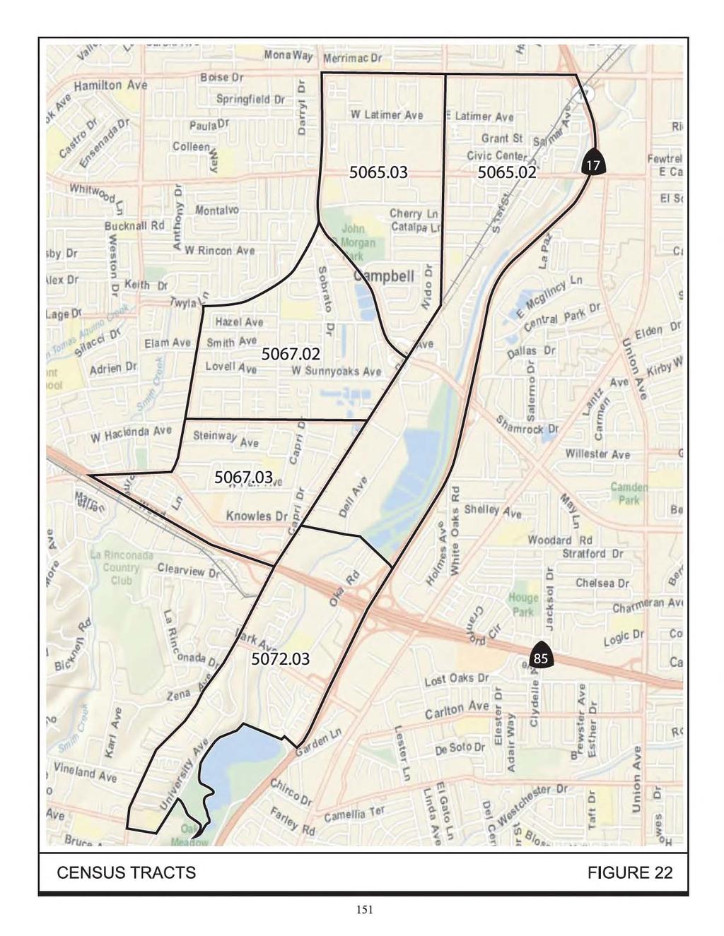
170
171 TABLE 33 Existing Demographics in the Project Study Area and in Santa Clara County Demographics Census Tract Census Tract Project Study Area Census Tract Census Tract Census Tract Santa Clara County Ethnicity (%) Asian American Black Hispanic Native American Total Minorities Economic Percent of Population Below Poverty Level Source: Year 2010 U.S. Census As is also shown in Table 33, the percentage of the population below the 2011 poverty level is well under 50 percent in each of the five census tracts that comprise the project study area. Further, when compared to Santa Clara County as a whole, the percentage of the population below poverty level is lower in four of the five census tracts. In Census Tract , the percentage of low-income persons is 14.7 percent, as compared to 13.4 percent for Santa Clara County. This 1.3 percent difference is not considered meaningfully greater. Further efforts to identify potential low-income populations included field surveys of the study area. The field surveys did not identify any environmental justice communities. As defined by the CEQ, there are, therefore, no environmental justice low-income populations present within the project study area Environmental Consequences There are no environmental justice communities present within the project study area. The identified adverse and beneficial impacts of the project would be the same for nonenvironmental justice populations, minority and low income populations. Vasona Corridor Light Rail Transit Extension 152 Draft SEIR/EA Santa Clara Valley Transportation Authority November 2012
172 Chapter 5.0 Section 4(f) Evaluation 5.1 INTRODUCTION The proposed project is a transportation facility that may receive federal funding through FTA and, therefore, documentation of compliance with Section 4(f) is required. Section 4(f) of the Department of Transportation Act of 1966 [49 U.S.C. 303], declares that it is the policy of the United States Government that special effort should be made to preserve the natural beauty of the countryside and public park and recreation lands, wildlife and waterfowl refuges, and historic sites. Section 4(f) specifies that the Secretary of Transportation may approve a transportation program or project that requires the use of publicly owned land of a public park, recreation area, or wildlife and waterfowl refuge of national, State, or local significance, or land of an historic site of national, State, or local significance 51 only if: there is no prudent and feasible alternative to using that land; and the program or project includes all possible planning to minimize harm to the park, recreation area, wildlife and waterfowl refuge, or historic site resulting from the use. Regulations and guidance for Section 4(f) compliance have been adopted by FTA. Under those regulations, the use of a protected Section 4(f) resource can take the form of the following: Direct Use: land is permanently incorporated into a transportation facility through partial or full acquisition; Temporary Occupancy: there is a temporary occupancy of land that is adverse in terms of the preservationist purposes of Section 4(f); or Constructive Use: there is no permanent incorporation of land, but the proximity of a transportation facility results in impacts (e.g., noise, vibration, visual, access, and/or ecological) so severe that the protected activities, features, or attributes that qualify a resource for protection under Section 4(f) are substantially impaired. The Section 4(f) regulations explain the conditions under which a temporary occupancy of property does not constitute a use of a Section 4(f) resource. For there to be no temporary use, the following requirements must be satisfied: 51 Significance is determined by the federal, state, or local officials having jurisdiction over the park, recreation area, wildlife refuge, or historic site. Vasona Corridor Light Rail Transit Extension 153 Draft SEIR/EA Santa Clara Valley Transportation Authority November 2012
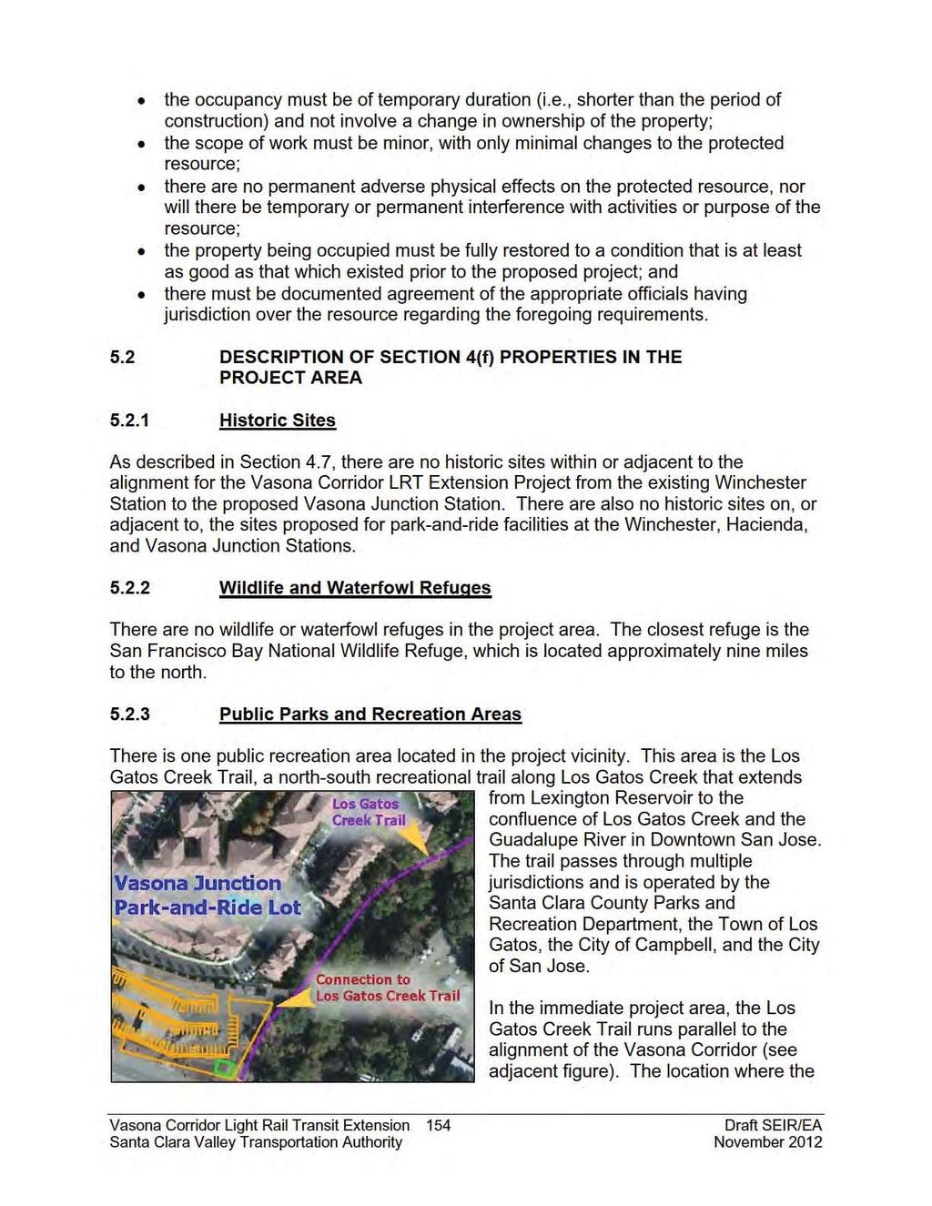
173