Profile of Five Beaches in Lebanon
|
|
|
- Ralph Butler
- 5 years ago
- Views:
Transcription
1 Agreement for Performance of Work WHO CNRS Ref: WHO registration 2011/ Purchase order Reg. File Profile of Five Beaches in Lebanon Prepared by: Milad Fakhri Roula Mina Marie Abboud Abi-Saab Elie Tarek Anthony Ouba Rita Mouawad Coordination: Gaby Khalaf National Centre for Marine Research, Batroun March
2 Profile of Five Beaches in Lebanon I. Heri beach II. Byblos Bahsa beach III. Ramlet-el-Bayda beach IV. Saida beach V. Tyr beach 1

3 2
4 I- Name of Beach and Bathing Area: Heri Beach, North Lebanon 4 1. General information 4 2. Description of the physical, chemical and hydrological characteristics of the bathing waters 7 3. Sanitary inspection 7 4. Microbiological water quality assessment 9 5. Assessment of the potential of eutrophication (proliferation of cynobacteria, macroalgae, phytoplankton) Meiofauna populations in the sand of Heri beach 10 3

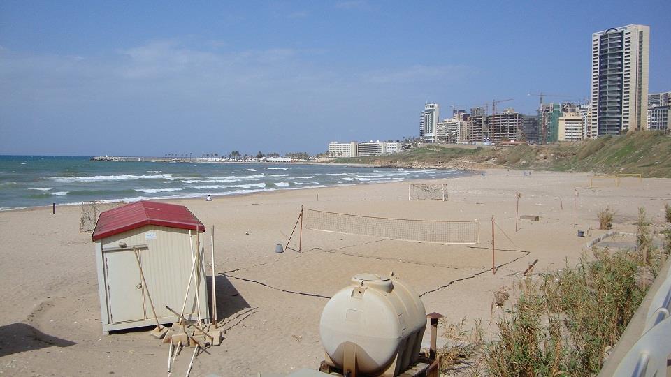
5 I- Name of Beach and Bathing Area: Heri Beach, North Lebanon 1. General Information Heri beach lies in a bay on a typical rocky coastal stretch of North Lebanon. This area is known by its sandy beaches and clear water. An important cement plant occupies the northern end of this beach and affects water quality by its industrial waste discharges. The Southwest end of the beach is full of hotels: one of the most important resorts is Florida beach. There are tourist facilities with accommodation all the way to the Factory. Most of the beach is covered by a concrete promenade. Each resort has its own private parking. The water depth increases slowly. Most of the bathing waters are shallow between 1 and 6 m deep (Fig.1). Table 1: General description of the beach Location From: N 34º ; E 35º To: N 34º ; E 35º Length of whole beach Width of beach Type of bathing water Type of beach area Number of bathers Characteristics of surrounding area 700 m 35 m at its widest part and 10 m at its narrowest part with mean width of 20 m Marine, relative open bay Sandy beach 400 (weekday) to 2000 (holiday peak) Urban, residential, agricultural and touristic area and mainly industrial Heri beach Fig. 1. The aerial view of Heri beach, North Lebanon 4


6 5


7 6
 to 29.2 C in summer (August).")
8 Fig. 2. The different views of Heri beach, North Lebanon 2. Description of the physical, chemical and hydrological characteristics of the bathing waters The water temperature at Heri public beach varies from 17 C in winter (March) to 29.2 C in summer (August). The annual average water temperature in this area is around 22.5 C. The salinity varies with a minimum of g.l -1 in winter and a maximum of g.l -1 in summer with an average value of g.l -1. The phosphate concentrations of water fluctuate between a minimum of 0.13 μm/l and a maximum of 0.89 μm/l with a mean annual value of 0.46 μm/l. The nitrate concentrations fluctuate between a minimum of 0.14 μm/l and a maximum of 0.97 μm/l with a mean annual value of 0.31 μm/l. Water is usually clear and transparent. No algae are observed all year around on this sandy beach. This beach is not frequented by dogs or other animals. Prevailing wind direction is south and south west. The residual current direction is generally towards North. The tidal Amplitude is A = 0.40 m. There is only one microbiological monitoring station in this beach with the following coordinates N 34º ; E 35º Sanitary inspection Heri beach is not affected by any sewage outfalls. Only an irrigation canal at the northern end of the beach flows into the seawater. It may increase the possibility of contamination with fertilizers and pesticides. Lines of fresh water may be seen on the shore. Their source might be the external showers used by bathers. There are also (garbage) litter bins with daily collection at the seashore. Often the beach looks clean in summer, but in winter, it is covered with rubbish, mostly consisting of plastic bags and bottles. The sand looks clean with light black lines and big black particles supposed to be Sulfide which is thrown by the plant directly into seawater. 7
9 Table 1: Site inspection risk category for Heri beach, North Lebanon Sewage Discharges Riverine Discharges Surface Runoff Bather Shedding Animal Inputs Present? Y/N Treatment Type of discharge Risk of discharge occurrence during bathing season Outfalls NO N/A Overflows from NO N/A SPS(1) Overflows from septic tanks, etc. Storm water Boating possibly from resorts rare N/A YES No Storm water Absent Low Density No Expected Rate of Dilution/Dispe rsion Proportion of boats which may release sewage(2) Present? Y/N YES Low Expected Presence of Presence of Volume agricultural animal Present during land: husbandry:? Y/N Bathing none/low/ none/low/ Season H/M/L medium/high medium/high (3) (3) YES High Yes None High Density of bathers Expected Rate of Dilution/ Dispersion Toilet Facilities None/Inadequ ate/adequate High Medium Adequate High Dog Presence of Density / Ban on other animals Frequency of Beach Animals Y/N NO Birds and Cats Low N/A OVERALL CATEGORY OF SANITARY INSPECTION (1) = Sewage Pumping Stations (2) = these would be larger boats and yachts (3) = sources of potential faecal contamination due to manure or animal wastes within the catchment area leading to bay (4) = animal inputs other than those due to runoff from agriculture/animal husbandry NA = Not applicable 8

10 The monitored bacteriological parameters are faecal coliforms and faecal streptococci. Sampling is done monthly from January 2008 till December The used methodology is the membrane filtration method recommended by WHO/UNEP, The analyses of this data are summarized in table 3. Fig. 4. Locations of the sampling points and the potential contamination sources 4. Microbiological water quality assessment Table 3: Microbiological water quality assessment Faecal coliform Station Heri beach Jan/ Dec/2010 No. of samples th percentile th percentile 11 Faecal streptococci Bacteriological water quality category No. of samples th percentile th percentile 77 Good 9
11 5. Assessment of the potential of eutrophication (proliferation of cynobacteria, macroalgae, phytoplankton) The possible nutrient sources include agriculture runoff and freshwater from marine springs. Historically, the data of phytoplankton concentrations are available but the phenomenon of eutrophication has never been recorded. The physical conditions of the beach (very windy, open sea and high current speed) are considered to be factors in favor of water mixing and a continual dispersion of continental inputs. The visual observations yielded no macroalgae growth but some Cymodocea nodosa (Monocotyledoneaeare) are found especially after a rough sea. Actually, data on nutrient and chlorophyll are available. Low risk for eutrophication is anticipated due to the water conditions and beach profile. 6. Meiofauna populations in the sand of Heri beach At Heri beach, the two groups Tardigrada and Nematoda the other meiobenthic populations with respective proportions of 34% and 23%. Many other groups are present at weaker density and occupy different ranks according to the years. The density of Nematoda is very low during January ( ind/10 cm 2 ). 10
12 II- Name of Beach and Bathing Area: Byblos Bahsa Beach, Jbeil, Lebanon General information Description of the physical, chemical and hydrological characteristics of the bathing waters Sanitary inspection Microbiological water quality assessment Assessment of the potential of eutrophication (proliferation of cynobacteria, macroalgae, phytoplankton) 15 11
13 II- Name of Beach and Bathing Area: Byblos Bahsa Beach, Jbeil, Lebanon 1. General information Byblos Bahsa beach is situated in the north of Byblos city. This area is considered as one of the most important touristic sites in Lebanon. It is well known by its valuable archeological sites, hotels, restaurants and beaches (Figure 2). Bahsa beach is located directly next to the main road and it is surrounded by restaurants, resorts and small parcels of agricultural lands. It is a mixture of sand and pebbles with the presence of some rocks. There is a parking beside of it. The beach is mainly frequented by the citizens of Byblos city and its suburbs and by passing tourists mainly for swimming and sunbathing. The water depth increases rapidly, with pebbles bottom and some patches of coarse sands and isolated small rocks. Most of the bathing waters are mid shallow between 1 and 10 m deep. Table 1: General description of the beach Location From: N 34º ; E 35º To: N 34º ; E 35º Length of whole beach Width of beach Type of bathing water Type of beach area Number of bathers Characteristics of surrounding area 250 m 30 m at its widest part. Marine, relative open bay Sandy, rocky and mostly pebble beach 500 (weekday) to 1500 (holiday peak) Urban, residential, agricultural and mainly touristic area 2. Description of the physical, chemical and hydrological characteristics of the bathing waters The water temperature at Byblos bahsa beach varies with a minimum of 17.5 C in winter (March) and a maximum of 30.2 C in summer (August). The annual average of water temperature in this area is around 23 C. The salinity varies from g.l - 1 in winter to g.l -1 in summer with an average value of g.l -1. Concerning nutrients, the phosphate concentrations of water fluctuate between a minimum of 0.10 μm/l and a maximum of 0.30 μm/l with a mean annual value of 0.19 μm/l. Furthermore, the nitrate concentrations fluctuate between a minimum of 0.24 μm/l and a maximum of 3.72 μm/l with a mean annual value of 1.32 μm/l. Water is usually clear and transparent. Algae cover the rocks all year around. Dogs or other animals are not seen. 12


14 Byblos Bahsa beach Fig. 1. The aerial view of Byblos Bahsa beach, Jbeil area 13

15 Fig. 2. The different views of Byblos Bahsa beach, Jbeil area Prevailing wind direction is south and south west. The residual current direction is generally towards North. The tidal Amplitude is A = 0.40 m. There is only one microbiological monitoring station on this beach with the following coordinates N 34º ; E 35º Sanitary inspection Upon the sanitary inspection, there are no sewage outfalls on this beach. On the other hand, this beach can be directly influenced by the pollution from the traffic since it s located next to the main road. Some infiltrations of irrigation water from the agricultural land may increase the possibility of seawater contamination with fertilizers and pesticides. In addition, it may receive some of water loaded with chlorine from the pool s water of the adjacent resorts. During summer, public toilets and external showers of two restaurants are available. There are also (garbage) litter bins with daily collection at the seashore. Often the beach looks clean in summer but dirty in winter where we can see lots of plastic bags and bottles. It is guarded by one security man hired by the municipality of Byblos to keep the beach safe and to prevent the entrance of animals and trouble makers. 4. Microbiological water quality assessment The monitored bacteriological parameters are faecal coliforms and faecal streptococci. Sampling is done monthly from January 2008 till December The used methodology is the membrane filtration method recommended by WHO/UNEP, The analyses of this data are summarized in table Assessment of the potential of eutrophication (proliferation of cynobacteria, macroalgae, phytoplankton) The possible nutrient sources include rain water, runoff from medium touristic complex, in winter and spring, during high current speed, from a river situated in the 14
16 south of this beach. The visual observations yielded the presence of macroalgae growth in the rocky part of the beach. Table 2: Site inspection risk category for Byblos Bahsa beach, Jbeil (Byblos), Lebanon Sewage Discharges Riverine Discharges Surface Runoff Bather Shedding Animal Inputs Present? Y/N Treatment Type of discharge Risk of discharge occurrence during bathing season Outfalls NO N/A Overflows from NO N/A SPS(1) Overflows from septic tanks, etc. Storm water Boating possibly from restaran ts N/A YES No Storm water Absent Low Density No Present? Y/N No Present? Y/N Expected Rate of Dilution/Dispe rsion Expected Volume during Bathing Season H/M/L Proportion of boats which may release sewage(2) Presence of agricultural land: none/low/ medium/high (3) Presence of animal husbandry: none/low/ medium/hig h (3) Low YES Low None None Low Expected Rate Toilet Density of Dilution/ Facilities of Dispersion None/Inadequ bathers at e/adequate High Medium Inadequate Low Dog Ban on Beach Y/N Presence of other animals Density / Frequency of Animals NO Birds and Cats Low N/A OVERALL CATEGORY OF SANITARY INSPECTION (1) = Sewage Pumping Stations (2) = these would be larger boats and yachts (3) = sources of potential faecal contamination due to manure or animal wastes within the catchment area leading to bay (4) = animal inputs other than those due to runoff from agriculture/animal husbandry NA = Not applicable 15

17 No recent data on the composition of phytoplankton and dissolved oxygen is available for this beach. The increased transparency and clearness of the water suggested that the risk for eutrophication is weak. Data on nutrient and chlorophyll is actually available. Agricultural lands Swimming resort Restaurants Sampling Point Swimming resort Fig.3. Locations of the sampling point and the potential contamination sources Table 3: Microbiological water quality assessment Faecal coliform Station Byblos bahsa beach Jan/ Dec/2010 No. of samples th percentile th percentile 9 Faecal streptococci Bacteriological water quality category No. of samples th percentile th percentile 73 Good 16
18 III- Name of Beach and Bathing Area: Ramlet-el-Bayda Beach, Ras Beirut, Lebanon General information Description of the physical, chemical and hydrological characteristics of the bathing waters Sanitary inspection Microbiological water quality assessment Assessment of the potential of eutrophication (proliferation of cynobacteria, macroalgae, phytoplankton) Meiofauna populations in the sand of Ramlet-el-Bayda public beach 23 17
. This area derives its name from the nearby and only sandy beach in Beirut.")
19 III- Name of Beach and Bathing Area: Ramlet-el-Bayda Beach, Ras Beirut, Lebanon 1. General information Ramlet-el-Bayda beach is situated in the south of Beirut city at the end of Ras-Beirut (Beirut Cap). This area derives its name from the nearby and only sandy beach in Beirut. It is characterized by luxurious apartment buildings ascribing to it a high standard of living. A number of important hotels are located in the immediate vicinity of this beach and some residential looking seawards (Coral Beach, Summerland and Movempick resorts). This beach is the most popular in the region, usually frequented by the citizens of Beirut and its suburbs. The water depth increases slowly, with a fine sandy bottom. Most of the bathing waters are mid shallow between 1 and 8 m deep. Table 1: General description of the beach Location From: N 3 3º ; E 35 º To: N 3 3º ; E 35 º Length of whole beach Width of beach Type of bathing water Type of beach area Number of bathers Characteristics of surrounding area 1065 m From m at its widest part. Marine, relative open bay Sandy beach 500 (weekday) to 3000 (holiday peak) Urban and residential Ramlet-el-Bayda public beach Fig. 1. The aerial view of Ramlet-el-Bayda beach, Beirut area 18


20 19


21 Fig. 2. The different views of of Ramlet-el-Bayda beach, Beirut area 20
22 2. Description of the physical, chemical and hydrological characteristics of the bathing waters The water temperature varies from 17 C in winter (March) to 30.8 C in summer (August). The annual average of water temperature in this area is around 23.5 C. The salinity varies with a minimum of g.l -1 in winter and a maximum of 39.6 g.l -1 in summer with an average value of g.l -1. Concerning nutrients, phosphate concentrations fluctuate between 0.39 μm/l and 3.93 μm/l with a mean annual of 1.52 μm/l. Furthermore, the nitrate concentrations fluctuate between 0.73 μm/l and μm/l with a mean annual of 3.58 μm/l. Water is usually turbid with a brown green colour. The prevailing wind direction is south and south west. Knowing that the residual current direction is generally towards north and the tidal amplitude is A = 0.40 m. There is only one microbiological monitoring station at this beach with the following coordinates N , N Sanitary inspection Upon the sanitary inspection, we notice the existence of two main raw waste water discharges (sewage outfalls); One at the north of this beach and the second at its south. The discharge is directly into the beach. These effluents are the main risk of pollution for this beach in addition to a stormwater discharge outlet. During summer some public toilets and showers are available along the beach. There are also litter bins with daily collection at the seashore. Often the beach looks clean. But we can notice the presence of solid wastes along of it especially in winter due to carelessness. Dogs are frequent on this beach, around five a day. On the other hand, and after the oil spill in 2006, we still find some traces of fuel at the depth 50 cm. 4. Microbiological water quality assessment The monitored bacteriological parameters are faecal coliforms and faecal streptococci. Sampling is done monthly from January 2008 till December The used methodology is the membrane filtration method recommended by WHO/UNEP, The analyses of this data are summarized in table Assessment of the potential of eutrophication (proliferation of cynobacteria, macroalgae, phytoplankton) The possible nutrient sources include agriculture runoff and sewage of the municipality coming from Beirut town situated at the south of the beach. These waters are carried out by the South North direction current during almost all the year. Historically, high concentrations of phytoplankton (including sometimes cyanobacteria) were noted and a moderate phenomenon of eutrophication has been recorded. The visual observations yielded the presence of macroalgae growth such as the species Padina pavonia. Data on nutrient, chlorophyll and phytoplankton are available. 21
23 Table 2: Site inspection risk category for Ramlet-el-Bayda beach, Ras Beirut, Lebanon Sewage Discharges Riverine Discharges Surface Runoff Bather Shedding Animal Inputs Present? Y/N Treatment Type of discharge Risk of discharge occurrence during bathing season Outfalls Yes No Yes N/A Overflows from SPS(1) Overflows from septic tanks, etc. Storm water Boating No NO possibly (from some buildings) No N/A N/A YES No Storm water Absent Low Density Present? Y/N Present? Y/N Expected Rate of Dilution/Di spe rsion Expected Volume during Bathing Season H/M/L Proportion of boats which may release sewage(2) Presence of agricultural land: none/low/ medium/high (3) Presence of animal husbandry: none/low/ medium/hig h (3) Low YES Low None None Low Expected Toilet Density of Rate of Facilities bathers Dilution/ None/Inadequ Dispersion at e/adequate High Medium Inadequate Low Dog Ban on Beach Y/N Yes Presence of other animals Birds and Density / Frequency of Animals Low Cats OVERALL CATEGORY OF SANITARY INSPECTION (1) = Sewage Pumping Stations (2) = these would be larger boats and yachts (3) = sources of potential faecal contamination due to manure or animal wastes within the catchment area leading to bay (4) = animal inputs other than those due to runoff from agriculture/animal husbandry NA = Not applicable N/A 22
24 Stormwatertrench outlet Southern Sewage Outfall Coral Beach & Summerland Resorts Sampling Point Northern Sewage outfall Movenpic Resort Fig.3. Locations of the sampling point and the potential contamination sources Table 3: Microbiological water quality assessment Faecal coliform Station Ramlet-el-Bayda public beach Jan/ Dec/2010 No. of samples th percentile th percentile Faecal streptococci Bacteriological water quality category No. of samples th percentile th percentile Poor quality 6. Meiofauna populations in the sand of Ramlet-el-Bayda public beach The study of meiofauna of Ramlet-el-Bayda beach showed that the nematodes are the most abundant among the other groups during the different seasons. Their density is quite important (70 %). The density of Tardigrada and Nemertiens groups comes in second and third place respectively. 23
25 IV. Name of Beach and Bathing Area: Saida Beach, Saida, South Lebanon General information Description of the physical, chemical and hydrological characteristics of the bathing waters Sanitary inspection Microbiological water quality assessment Assessment of the potential of eutrophication (proliferation of cynobacteria, macroalgae, phytoplankton) 28 24

26 IV- Name of Beach and Bathing Area: Saida Public Beach, Saida, South Lebanon 1. General information Saida public beach is situated at the northern end of Saida city. The beach is located directly next to the main road. There is a parking beside of it for visiting cars and buses. This beach is mainly frequented by the citizens of Saida city for swimming and sunbathing. The water depth increases slowly. Most of the bathing waters are shallow between 1 and 7 m deep. Table 1: General description of the beach Location From: N 34º ; E 35º To: N 34º ; E 35º Length of whole beach Width of beach Type of bathing water Type of beach area Number of bathers Characteristics of surrounding area 673 m 90 m at its widest part Open Marine Beach Sandy 600 (weekday) to 4000 (holiday peak) Urban, residential, agricultural and touristic area Saida public beach Fig. 1. The aerial view of Saida public beach, Saida area South Lebanon 25


27 26


28 Fig. 2. The different views of Saida public beach, Saida area South Lebanon 27
29 2. Description of the physical, chemical and hydrological characteristics of the bathing waters The water temperature at Saida public beach varies between 17.4 C in winter (March) and 30 C in summer (August). The annual average water temperature of this area of Saida is around 22.8 C. The salinity varies between a minimum of g.l -1 in winter and a maximum of g.l -1 in summer with an average value of g.l -1. On the other hand, phosphate concentrations in water fluctuate with a minimum of 0.17 μm/l and a maximum of 1.27 μm/l with a mean annual value of 0.52 μm/l. Nitrate concentrations fluctuate between a minimum of 0.96 μm/l and a maximum of 6.05 μm/l with a mean annual value of 2.66 μm/l. Water is usually clear and transparent. Some algae (Ulva, Enteromorpha) are observed all around the year in the vicinity of southern waste water outfall. This beach is frequented by dogs during winter and only by birds during summer season. The prevailing wind direction is south and south west. The residual current direction is generally towards North. The tidal Amplitude is A = 0.40 m. There is only one microbiological monitoring station in this beach with the following coordinates N 33º ; E 35º Sanitary inspection Upon the sanitary inspection, we notice the existence of two main raw waste water discharges (sewage outfalls), one at the north and the second at the south, flowing directly onto the beach. These effluents are the main risk of pollution. Beside this, it may receive some irrigation water infiltrated from nearby agricultural lands which may increase the possibility of seawater contamination with fertilizers and pesticides. It also receives the surface runoff water (stormwater) from the above road during winter. During summer, there are some public toilets and showers installed by the municipality all along the beach. There are also (garbage) litter bins with daily collection at the seashore. During summer the beach looks clean but very dirty in winter where we can see lots of plastic bags and bottles. There are few lifeguards to prevent and save people from sinking. For more security there is a line of floating buoys indicating for swimmers the limit area for safe swimming. 4. Microbiological water quality assessment The monitored bacteriological parameters are faecal coliforms and faecal streptococci. Sampling is done monthly from January 2008 till December The used methodology is the membrane filtration method recommended by WHO/UNEP, The analyses of this data are summarized in table Assessment of the potential of eutrophication (proliferation of cynobacteria, macroalgae, phytoplankton) The possible nutrient sources include agriculture runoff and sewage of Saida municipality situated at the south of the beach; water is carried by the current South North direction during the most of the year. 28
30 Table 2: Site inspection risk category for Saida public beach, Lebanon Sewage Discharges Riverine Discharges Surface Runoff Bather Shedding Animal Inputs Present? Y/N Treatment 29 Type of discharge Risk of discharge occurrence during bathing season Outfalls Yes NO N/A Overflows from NO N/A SPS(1) Overflows from septic tanks, etc. Storm water Boating No N/A YES No Storm water Absent Low Density No Present? Y/N No Present? Y/N Expected Rate of Dilution/Dispe rsion Expected Volume during Bathing Season H/M/L Proportion of boats which may release sewage(2) Presence of agricultural land: none/low/ medium/high (3) Presence of animal husbandry: none/low/ medium/hig h (3) Low YES Low Medium None Medium Expected Rate Toilet Density of Dilution/ Facilities of Dispersion None/Inadequ bathers at e/adequate High Medium Inadequate Low Dog Ban on Beach Y/N Presence of other animals Density / Frequency of Animals NO Birds Low N/A OVERALL CATEGORY OF SANITARY INSPECTION (1) = Sewage Pumping Stations (2) = these would be larger boats and yachts (3) = sources of potential faecal contamination due to manure or animal wastes within the catchment area leading to bay (4) = animal inputs other than those due to runoff from agriculture/animal husbandry NA = Not applicable The physical conditions of the beach (windy, open sea and straight coastline) are considered to be factors in favor of the dispersion of continental inputs. Historically, high concentrations of phytoplankton (including sometimes cyanobacteria) were available and a moderate phenomenon of eutrophication has been recorded. The visual observations yielded no macroalgae growth but some Cymodocea nodosa

31 (Monocotyledonea) are found. Data on nutrient and chlorophyll concentration is actually available. Northern Sewage outfall Sampling Point Agricultural lands Southern Sewage Outfall Fig.3. Locations of the sampling point and the potential contamination sources Table 3: Microbiological water quality assessment Faecal coliform Station Saida public beach Nov/ Dec/2010 No. of samples th percentile th percentile Faecal streptococci Bacteriological water quality category No. of samples th percentile th percentile 2189 Poor quality 30
32 V. Name of Beach and Bathing Area: Tyr reserve public beach, Tyr (Sour), South Lebanon General information Description of the physical, chemical and hydrological characteristics of the bathing waters Sanitary inspection Microbiological water quality assessment Assessment of the potential of eutrophication (proliferation of cynobacteria, macroalgae, phytoplankton) Meiofauna populations in the sand of Tyr reserve public beach 37 31

33 V- Name of Beach and Bathing Area: Tyr reserve public beach, Tyr (Sour), South Lebanon 1. General Information Tyr reserve public beach is situated at the south western side of Tyr (Sour) city. It is located 200 m to the west of the main road. This beach is characterized by its mild to coarse calcareous fine sand, mechanically compacted at the start of high season to install approximately sixty kiosks located 40m from the shoreline. Tables and chairs occupy a large beachfront area. They are annually removed by the municipality in September. There is a car parking behind which became a small swamp in winter. The water depth increases slowly. Most of the bathing waters are shallow between 1 and 8 m depth. Table 1: General description of the beach Location From: N 33º ; E 35º To: N 33º ; E 35º Length of whole beach Width of beach Type of bathing water Type of beach area Number of bathers Characteristics of surrounding area 2030 m 210 m at its widest part Open Marine Beach Sandy 1000 (weekday) to 5000 (holiday peak) Urban, agricultural and touristic area Tyr reserve public beach Fig. 1. The aerial view of Tyr reserve public beach, Tyr (Sour), South Lebanon 32


34 33


, South")
35 Fig. 2. The different views of Tyr reserve public beach, Tyr (Sour), South Lebanon 34
36 2. Description of the physical, chemical and hydrological characteristics of the bathing waters The water temperature at Tyr reserve public beach varies between 17.2 C in winter (March) and 30.1 C in summer (August). The annual average water temperature in this area is around 22.8 C. The salinity varies with a minimum of g.l -1 in winter and a maximum of g.l -1 in summer and an average value of g.l -1. Phosphate concentrations of water fluctuate between a minimum of 0.12 μm/l and a maximum of 0.28 μm/l with a mean annual value of 0.20 μm/l, while nitrate concentrations fluctuate between a minimum of 0.52 μm/l and a maximum of μm/l with a mean annual value of 4.72 μm/l. Water is usually clear and transparent. No algae are observed all year around on this beach. This beach is frequented by birds. The dominant wind is south and south west wind. The residual current direction is generally towards North. The tidal Amplitude is A = 0.40 m. There is only one microbiological monitoring station on this beach with the following coordinates N 33º ; E 35º Sanitary inspection This beach is located 500 m far from the main road so pollution from cars exhausts is insignificant. There are no visible waste water discharges on this beach. At its northern end is localised the biggest resort of Tyr (Rest House of Tyr) and at its southern end a huge agglomeration of houses representing the Palestinian camp; these 2 complexes may increase the probability of contamination of Tyr beach with fecal (bacteria, fungi and viruses) and chemical agents (chlorine used in pools and detergents). Add also the presence of drainage trench filled with solid wastes. This canal is collecting the surplus of irrigation waters coming from nearby agricultural lands loaded with fertilizers and pesticides. It also receives the surface runoff water from the road during winter. Litter bins are daily collected at the seashore. During summer the beach looks clean and mildly dirty in winter. There are few lifeguards to prevent and save people from sinking. The parking is secured with security men to avoid any troubles. 4. Microbiological water quality assessment The monitored bacteriological parameters are faecal coliforms and faecal streptococci. Sampling is done monthly from January 2008 till December The used methodology is the membrane filtration method recommended by WHO/UNEP, The analyses of this data are summarized in table Assessment of the potential of eutrophication (proliferation of cynobacteria, macroalgae, phytoplankton) The possible nutrient sources include rain water. The physical conditions of the beach (small depth of the water, large beach) are considered to be important factors in increasing turbidity during rough sea and water temperature during calm sea. Historically, data of phytoplankton were available and showed normal concentration with high diversity index; consequently, low risk for eutrophication is anticipated. Data on nutrient and chlorophyll concentration is actually available. 35
37 Table 2: Site ispection risk category for Tyr reserve public beach, Tyr (Sour), South Lebanon Sewage Discharges Riverine Discharges Surface Runoff Bather Shedding Animal Inputs Present? Y/N Treatment Type of discharge Risk of discharge occurrence during bathing season Outfalls No N/A Overflows from NO N/A SPS(1) Overflows from septic tanks, etc. Storm water Boating May be from the resort at the norther side N/A YES No Storm water Absent Low Density No Present? Y/N YES Present? Y/N Expected Rate of Dilution/Dispe rsion Expected Volume during Bathing Season H/M/L Proportion of boats which may release sewage(2) Presence of agricultural land: none/low/ medium/high (3) Presence of animal husbandry: none/low/ medium/hig h (3) Low YES Low High None Medium Expected Rate Toilet Density of Dilution/ Facilities of Dispersion None/Inadequ bathers at e/adequate High Medium Adequate Low Dog Ban on Beach Y/N Presence of other animals Density / Frequency of Animals NO Birds Low N/A OVERALL CATEGORY OF SANITARY INSPECTION (1) = Sewage Pumping Stations (2) = these would be larger boats and yachts (3) = sources of potential faecal contamination due to manure or animal wastes within the catchment area leading to bay (4) = animal inputs other than those due to runoff from agriculture/animal husbandry NA = Not applicable 36

38 Stormwatertrench outlet Agricultural lands Tyr Swimming Resort Fig.3. Locations of the sampling point and the potential contamination sources Table 3: Microbiological water quality assessment Faecal coliform Station Tyr reserve beach Nov/ Dec/2010 No. of samples th percentile th percentile 41 Faecal streptococci Bacteriological water quality category No. of samples th percentile th percentile 109 Good 6. Meiofauna populations in the sand of Tyr reserve public beach The meiofauna populations of Tyr reserve beach are quite particular. They represent great diversity with the dominance of multiple groups (Copepods, Tardigrada, Nematoda, Polychaetes). Many other groups are also present (Oligochaetes, Nauplii, 37
39 Turbellaria) and others have even lower density (Archiannelida, Gastrotricha, Collemboles ). The average density is high during the four seasons; they fluctuate between 600 and 800 ind/10cm 2. 38