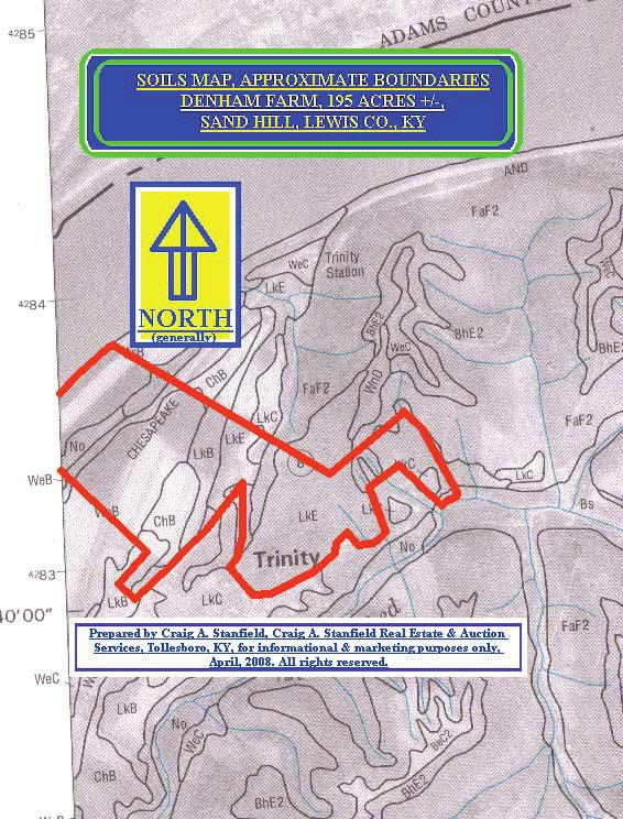
Soil Map Lewis County, Kentucky (Denham Farm, Sand Hill/Trinity, Lewis Co., KY) Web Soil Survey National Cooperative Soil Survey
|
|
|
- Stuart Berry
- 5 years ago
- Views:
Transcription
 83 36' 18'' W 38 40' 37'' N 271500 271700 271900 272100 272300 272500 272700 272900 273100 273300 38 40' 37'' N 38 39' 54'' N 4282900 4283100 4283300 4283500 4283700 4283900 4284100 271300")
1 83 37' 43'' W (Denham Farm, Sand Hill/Trinity, Lewis Co., KY) 83 36' 18'' W 38 40' 37'' N ' 37'' N 38 39' 54'' N ' 54'' N 83 37' 43'' W N Map Scale: 1:9,410 if printed on A landscape (11" x 8.5") sheet. Meters Feet Map projection: Web Mercator Corner coordinates: WGS84 Edge tics: UTM Zone 17N WGS ' 18'' W Page 1 of 3
2 (Denham Farm, Sand Hill/Trinity, Lewis Co., KY) MAP LEGEND MAP INFORMATION Area of Interest (AOI) Area of Interest (AOI) Soils Soil Map Unit Polygons Soil Map Unit Lines Soil Map Unit Points Special Point Features Blowout Borrow Pit Clay Spot Closed Depression Gravel Pit Gravelly Spot Landfill Lava Flow Marsh or swamp Mine or Quarry Miscellaneous Water Perennial Water Rock Outcrop Saline Spot Sandy Spot Severely Eroded Spot Sinkhole Slide or Slip Sodic Spot Spoil Area Stony Spot Very Stony Spot Wet Spot Other Special Line Features Water Features Streams and Canals Transportation Rails Interstate Highways US Routes Major Roads Local Roads Background Aerial Photography The soil surveys that comprise your AOI were mapped at 1:20,000. Warning: Soil Map may not be valid at this scale. Enlargement of maps beyond the scale of mapping can cause misunderstanding of the detail of mapping and accuracy of soil line placement. The maps do not show the small areas of contrasting soils that could have been shown at a more detailed scale. Please rely on the bar scale on each map sheet for map measurements. Source of Map: URL: Coordinate System: Web Mercator (EPSG:3857) Maps from the are based on the Web Mercator projection, which preserves direction and shape but distorts distance and area. A projection that preserves area, such as the Albers equal-area conic projection, should be used if more accurate calculations of distance or area are required. This product is generated from the USDA-NRCS certified data as of the version date(s) listed below. Soil Survey Area: Lewis County, Kentucky Survey Area Data: Version 9, Sep 14, 2012 Soil map units are labeled (as space allows) for map scales 1:50,000 or larger. Date(s) aerial images were photographed: Jun 30, 2010 Oct 15, 2011 The orthophoto or other base map on which the soil lines were compiled and digitized probably differs from the background imagery displayed on these maps. As a result, some minor shifting of map unit boundaries may be evident. Page 2 of 3
3 Denham Farm, Sand Hill/Trinity, Lewis Co., KY Map Unit Legend AsB BhE2 Bs Lewis County, Kentucky (KY135) Map Unit Symbol Map Unit Name Acres in AOI Percent of AOI Ashton silt loam, 2 to 6 percent Beasley-Shrouts complex, 12 to 30 percent, very rocky, eroded Boonesboro silt loam, frequently flooded ChB Chavies fine sandy loam, 2 to 6 percent ChC FaF2 LkB Chavies fine sandy loam, 6 to 12 percent Fairmount-Faywood complex, 20 to 55 percent, very rocky, eroded Lakin loamy sand, 2 to 8 percent LkC Lakin loamy sand, 8 to 15 percent LkE Lakin loamy sand, 15 to 35 percent Me No Melvin silt loam, frequently flooded Nolin silt loam, occasionally flooded % % % % % % % % % % % W Water % WeB WnD Wheeling loam, 2 to 6 percent Wheeling-Nolin complex, 2 to 30 percent % % Totals for Area of Interest % Page 3 of 3
4
5 SOIL TYPES, BRIEF DESCRIPTION & SLOPE DENHAM FARM, 195 ACRES +/-, SAND HILL, LEWIS CO., KY Soils descriptions are condensed from those descriptions within the Soil Survey of Lewis County, Kentucky, with the subject property shown on Map # 2. Soil types for the subject property include those of the Ashton silt loam (AsB) variety; the Nolin silt loam (No) variety; the Melvin silt loam (Me) variety; the Wheeling loam (WeB) variety; the Lakin loamy sand (LkB, LkC, LkE) varieties; the Fairmount-Faywood complex (FaFw) variety; and the Beasley-Shrouts complex (BhE2) variety. AsB Ashton silt loam, 2 to 6 percent. Very deep, well drained, soil generally found on low terraces on the Ohio River flood plain. Available water capacity high; permeability moderate; runoff medium. Natural fertility medium, organic matter content moderate, depth to bedrock more than 60 inches, seasonal high water table at a depth of more than 72 inches, tilth good, shrink-swell potential low, hazard of erosion moderate. Well suited to cropland, hay, and pasture uses, woodland, wildlife habitat, recreation, and septic tank absorption fields; generally well suited to building site development. No - Nolin silt loam, 0 to 3 percent, occasionally flooded. Deep, well drained, nearly level soil on flood plains in the Ohio River Valley. Available water capacity high, permeability moderate, runoff very slow. Natural fertility high, organic matter content moderate, depth to bedrock more than 60 inches, seasonal high water table at depth of more than 72 inches, tilth good, shrink-swell potential low, hazard of erosion none or slight. Well suited to crops, pasture and hay uses, woodland, and wildlife habitat; suited to recreation; unsuited to building site development and septic tank absorption fields. Me Melvin silt loam, 0 to 2 percent, occasionally flooded. Very deep, poorly drained soil on river and stream valleys and flood plains. Available water capacity high, permeability moderate, runoff slow. Natural fertility medium, organic matter content low to moderate, depth to bedrock more than 60 inches, seasonal high water table at a depth of 0 to 12 inches, tilth good, shrink-swell potential low, hazard of erosion none or slight. Suited to some crops, hay and pasture uses and woodlands. Unsuited to recreational and building site development and septic tank absorption fields; poorly suited to wildlife habitat. WeB Wheeling loam, 2 to 6 percent. Very deep, well drained soil on terraces in the Ohio River Valley. Available water capacity high, permeability moderate, runoff medium. Natural fertility medium, depth to bedrock more than 60 inches, seasonal high water table at a depth of more than 60 inches, tilth good, shrink-swell potential low, hazard of erosion moderate. Well suited to crops, hay and pasture, woodland, recreation, wildlife habitat, and building site development; suited to septic tank absorption fields. LaB - Lakin loamy sand 2 to 8 percent. Very deep, excessively drained soil found on terraces in the Ohio River Valley. Available water capacity low, permeability rapid, runoff medium. Natural fertility medium, depth to bedrock more than 60 inches, seasonal high water table at a depth of more than 72 inches, tilth good, shrink-swell potential low, hazard of erosion moderate. Suited to cropland, recreation, and building site development; well suited to hayland, pasture, and woodlands, poorly suited to septic tank absorption fields. LaC Lakin loamy sand, 8 to 15 percent. Very deep, excessively drained soil found on terraces in the Ohio River Valley. Available water capacity low, permeability rapid, runoff rapid. Natural fertility medium, depth to bedrock more than 60 inches, seasonal high water table at a depth of more than 72 inches, tilth good, shrink-swell potential low, hazard of erosion severe. Poorly suited to cropland and septic tank absorption fields, well suited to hayland and pasture uses, woodlands and wildlife habitat; suited to recreation and building site development; poorly suited to septic tank absorption fields. LaE Lakin loamy sand, 15 to 35 percent. Very deep, excessively drained soil found on terraces and upland side in the Ohio River Valley. Available water capacity low, permeability rapid, runoff rapid or very rapid. Natural fertility medium, depth to bedrock more than 60 inches, seasonal high water table at a depth of more than 72 inches, tilth good, shrink-swell potential low, hazard of erosion severe. Unsuited to cropland and septic tank absorption fields, poorly suited to hayland, suited to pasture uses, well suited to woodlands, suited to wildlife habitat; suited to building site development; poorly suited to septic tank absorption fields. BhE2 Beasley-Shrouts complex, 12 to 30 percent, very rocky, eroded. Deep to moderately deep, well-drained soil found on upland side. Beasley soils have moderate available water capacity, permeability moderately slow, runoff rapid. Natural fertility medium, depth to bedrock 40 to 60 inches, seasonal high water table at a depth of more than 72 inches, tilth fair, shrink-swell potential moderate, hazard of erosion severe. Shrouts soils have low available water capacity, permeability very slow, runoff rapid. Natural fertility medium, depth to bedrock 20 to 40 inches, seasonal high water table at a depth of more than 72 inches, tilth fair, shrink-swell potential moderate, hazard of erosion severe. Unsuited to cropland uses, poorly suited to hay production, suited to pasture uses, suited to woodlands, poorly suited to recreationa, suited to wildlife habitat, poorly suited to building site development; poorly suited or unsuited to septic tank absorption fields. FaF2 Fairmount-Faywood complex, 20 to 55 percent, very rocky, eroded. Shallow to moderately deep, well drained soils found on upland sides. Fairmount soils have very low available water capacity, permeability slow or moderately slow, runoff rapid or very rapid. Natural fertility medium, depth to bedrock 10 to 20 inches, seasonal high water table at a depth of more than 72 inches, tilth poor, shrink-swell potential moderate, hazard of erosion severe. Faywood soils have low available water capacity, permeability slow or moderately slow, runoff rapid or very rapid. Natural fertility medium, depth to bedrock 20 to 40 inches, seasonal high water table at a depth of more than 72 inches, tilth fair, shrink-swell potential moderate, hazard of erosion severe. Unsuited to crops or hay production, suited to pasture, woodland, and wildlife habitat, unsuited to recreation, building site development and septic tank absorption fields.