USDA WESTERN HUMAN NUTRITION RESEARCH CENTER. University of California, Davis
|
|
|
- Leona Price
- 5 years ago
- Views:
Transcription
1 TIERED INITIAL STUDY USDA WESTERN HUMAN NUTRITION RESEARCH CENTER University of California, Davis Prepared by: University of California, Davis Planning and Budget Office 376 Mrak Hall One Shields Avenue Davis, CA Contact: A. Sidney England, Environmental Planner 530/ Environmental Consultant: EIP Associates 1200 Second Street Suite 200 Sacramento, CA Contact: Catherine McEfee, Senior Project Manager 916/ October 1999 This statement is prepared in compliance with the California Environmental Quality Act
2 TABLE OF CONTENTS Chapter Page I. BACKGROUND...1 Introduction...2 Public and Agency Review...4 Organization of Tiered Initial Study...4 II. III. PROJECT DESCRIPTION...6 Project Location...6 UC Davis...6 Project Description...6 Project Site...6 Land Use Designation...9 Background and Need for Project...9 Project Elements...11 Project Schedule...15 Project Objectives...15 Project Approval...16 CONSISTENCY WITH 1994 LRDP and LRDP EIR...17 Introduction LRDP Scope of Development LRDP Land Use Designations LRDP Population Projections LRDP EIR Cumulative Analysis LRDP Objectives...22 IV. TIERED ENVIRONMENTAL CHECKLIST...23 V. ENVIRONMENTAL FACTORS POTENTIALLY AFFECTED VI. VII. MITIGATION MEASURES LIST OF AGENCIES AND PERSONS COMMENTING VIII. RESPONSES TO COMMENTS IX. MITIGATION MONITORING PROGRAM X. DETERMINATION F:\DATA\ONLINEDOCS\USDAIS\TOC1.WPD i
3 Table of Contents APPENDICES A. Proposed Amendments to the 1994 LRDP and Revisions to the 1994 LRDP F:\DATA\ONLINEDOCS\USDAIS\TOC1.WPD ii
4 Table of Contents List of Figures Figure Page 1. Regional Location WHNRC Building Project Site Plan WHNRC Building Project Proposed LRDP Land Use Changes WHNRC Building Project Building Setbacks...13 F:\DATA\ONLINEDOCS\USDAIS\TOC1.WPD iii
5 Table of Contents List of Tables Table Page 1. Building Space Inventory and Building Space Need Projections Year Projected Campus Population Summary of Cumulative Risks for LRDP Motorized Vehicle Trip Generation A.M. Peak Hour Existing Plus Project Intersection Operating Conditions P.M. Peak Hour Existing Plus Project Intersection Operating Conditions A.M. Peak Hour Cumulative Intersection Operating Conditions P.M. Peak Hour Cumulative Intersection Operating Conditions...54 F:\DATA\ONLINEDOCS\USDAIS\TOC1.WPD iv
6 TIERED INITIAL STUDY I. BACKGROUND 1. Name of Project Sponsor: University of California 2. Campus: Davis 3. County: Yolo 4. Address and Phone Number of Campus Contact: Planning and Budget One Shields Avenue University of California, Davis Davis, CA (530) Date Checklist Completed: October 27, Agency Requiring Checklist: University of California 7. Name of Project: 8. Lead Agency: The Regents of the University of California 1
7 Introduction This Tiered Initial Study and proposed Negative Declaration provides the California Environmental Quality Act (CEQA) environmental analysis for the proposed United States Department of Agriculture (USDA) Western Human Nutrition Research Center (WHNRC). The environmental analysis for the proposed project is tiered from the University of California, Davis 1994 Long Range Development Plan (LRDP) Environmental Impact Report (EIR) for project-specific and cumulative impacts that were evaluated in the 1994 LRDP EIR. The 1994 LRDP is a program EIR, prepared pursuant to Section of the California Environmental Quality Act (CEQA) Guidelines (Title 14, California Code of Regulations, Sections et seq.). The 1994 LRDP EIR analyzed full implementation of uses and physical development proposed under the 1994 LRDP through the year and identified measures to mitigate the significant adverse project and cumulative impacts associated with that growth. The environmental analysis in the 1994 LRDP EIR was revised by the EIR prepared for the Wastewater Treatment Plant (WWTP) Replacement Project in March 1997 (State Clearinghouse # and # ), by the Major Capital Improvement Projects Supplemental EIR (SEIR), certified on July 17, 1998 (State Clearinghouse # ), and by the Center for the Arts Performance Hall and South Entry Roadway and Parking Improvements (Center for the Arts) Tiered Initial Study and Mitigated Negative Declaration (State Clearinghouse # ). Hereafter, references to the 1994 LRDP EIR include the 1994 LRDP EIR as revised by the 1997 WWTP EIR, the Major Capital Improvement Projects SEIR, and the Center for the Arts Tiered Initial Study and Mitigated Negative Declaration unless otherwise noted. The CEQA concept of "tiering" refers to the coverage of general environmental matters in broad program-level EIRs, with subsequent focussed environmental documents for individual projects that implement the program. The project environmental document incorporates by reference the discussions in the Program EIR and concentrates on project-specific issues. CEQA and the CEQA Guidelines encourage the use of tiered environmental documents to reduce delays and excessive paperwork in the environmental review process. This is accomplished in tiered documents by eliminating repetitive analyses of issues that were adequately addressed in the Program EIR and by incorporating those analyses by reference. In accordance with CEQA Sections and 15168(c), this project is tiered to the 1994 LRDP EIR (State Clearinghouse # ) as revised by the 1997 WWTP Replacement Project EIR (State Clearinghouse # and # ), by the Major Capital Improvement Project SEIR (State Clearinghouse # ), and by the Center for the Arts Tiered Initial Study and Mitigated Negative Declaration (State Clearinghouse # ) which are hereby incorporated by reference, and which are available for review during normal operating hours at the UC Davis Planning and Budget Office at 376 Mrak Hall, University of California, Davis. The tiering of the environmental analysis for the proposed project allows this Tiered Initial Study to rely on the 1994 LRDP EIR for the following: (a) (b) a discussion of general background and setting information for environmental topic areas; overall growth-related issues; 2
8 (c) (d) issues that were evaluated in sufficient detail in the 1994 LRDP EIR for which there is no significant new information or change in circumstances that would require further analysis; and long-term cumulative impacts. Thus, this Tiered Initial Study should be viewed in conjunction with the UC Davis 1994 LRDP EIR. The purpose of this Tiered Initial Study is to evaluate the potential environmental impacts of the project with respect to the 1994 LRDP EIR to determine what level of additional environmental review, if any, is appropriate. Based on the analysis contained in this Tiered Initial Study, one of the following determinations will be made: the project is exempt from CEQA; the project incrementally contributes to, but does not exceed, environmental impacts previously identified in the 1994 LRDP EIR, no additional mitigation measures are required, and preparation of Findings consistent with this determination is appropriate; the project would result in new impacts that were not previously identified in the 1994 LRDP EIR, but there is no substantial evidence that such new impacts may have a significant effect on the environment and preparation of a Negative Declaration is appropriate; the project would result in new potentially significant impacts that were not previously identified in the 1994 LRDP EIR, but proposed project-specific mitigation measures would reduce such impacts to a point where clearly no significant effects would occur and there is no substantial evidence that the project as mitigated may have a significant effect on the environment, in which case preparation of a mitigated Negative Declaration would be appropriate; the project would result in new significant environmental impacts not previously identified in the LRDP EIR, and preparation of a tiered EIR would be appropriate. Mitigation measures identified in the 1994 LRDP EIR that apply to the proposed project will be required to be implemented as part of the project. Project-specific mitigation measures for new potentially significant impacts that were not previously identified in the 1994 LRDP EIR will also be required to be implemented as part of the proposed project. The mitigation measures in the 1994 LRDP EIR that are appropriate to be implemented as part of the project are identified and discussed in Section IV. Because none of the conditions described in CEQA or the CEQA Guidelines calling for preparation of a subsequent EIR have occurred, the Initial Study includes only minor technical changes or additions to the analysis set forth in the 1994 LRDP EIR, and because the analysis in the Initial Study does not raise important new issues about the significant effects on the environment analyzed in the LRDP EIR, this Initial Study also serves as an addendum to the LRDP EIR, for purposes of the approval of the proposed project. 3
9 Public and Agency Review This Tiered Initial Study was circulated for public and agency review from September 15, 1999 to October 15, Comments on this Initial Study were to: Richard F. Keller Planning and Budget Office, 376 Mrak Hall University of California One Shields Avenue Davis, CA Copies of the Draft Tiered Initial Study were available at the UC Davis Planning and Budget Office at 376 Mrak Hall, UC Davis; the Reserve Reading Room, Shields Library, UC Davis; the Yolo County Public Library, 315 E. 14th Street, Davis; and the Fairfield Suisun Community Library, 1150 Kentucky Street, Fairfield. Copies of the 1994 LRDP and LRDP EIR, WWTP EIR, Major Capital Improvement Projects SEIR, and Center for the Arts Tiered Initial Study and Mitigated Negative Declaration are also available at these locations. Organization of Tiered Initial Study This Tiered Initial Study is organized into the following sections. Section I - Background: provides summary background information about the project sponsor, proposed project, and 1994 LRDP. In addition, this section includes a summary introduction and description of the content of the Initial Study. Section II - Project Description: includes the description of the proposed project. Section III - Consistency with the 1994 LRDP and 1994 LRDP EIR: describes the consistency of the proposed project with the 1994 LRDP and 1994 LRDP EIR. Section IV - Environmental Checklist: contains the Tiered Environmental Checklist form. The Checklist form is used to assist in evaluating the potential environmental impacts of the proposed project with respect to the 1994 LRDP EIR. The Checklist form identifies potential project effects as follows: (1) new potentially significant project impacts that were not adequately analyzed in the 1994 LRDP EIR, or previously identified significant impacts for which new feasible mitigation measures are available; (2) new less-than-significant impacts; (3) environmental impacts of the project that were adequately analyzed and mitigated in the 1994 LRDP EIR; and (4) effects that would not result in any adverse environmental impact. This section also contains an explanation of all checklist answers, and recommended 1994 LRDP EIR mitigation measures and project-specific mitigation measures, as appropriate. Section V - Environmental Factors Potentially Affected: identifies which environmental factors were determined to be a "Potentially Significant Impact" as indicated by the Tiered Environmental Checklist. Section VI - Mitigation Measures: summarizes 1994 LRDP EIR and project-specific mitigation measures identified in Section IV, as appropriate. 4
10 Section VII - Determination: indicates whether impacts associated with the proposed project are significant, and what, if any, additional environmental documentation would be required. 5
11 II. PROJECT DESCRIPTION Project Location UC Davis The 5,300 acre UC Davis Campus is located in Yolo and Solano Counties approximately 72 miles northeast of San Francisco, 15 miles west of the City of Sacramento, and adjacent to the City of Davis (see Figure 1). The Campus, in general, is comprised of four campus units: the Central Campus, the South Campus, the West Campus, and Russell Ranch (please see Figure 3-2, Regional and Local Setting, on page 3-5 of the 1994 LRDP DEIR). The "Main Campus" refers to the Central, South, and West Campus units, excluding Russell Ranch. Most of the academic and extracurricular activities occur within the Central Campus. The Central Campus is bounded approximately by Russell Boulevard to the north, State Route 113 (SR 113) to the west, Interstate 80 (I-80) and the Union Pacific Railroad tracks to the south and 1st or A Street to the east. The South Campus is located south of I-80 and north of the South Fork of Putah Creek. The West Campus is located to the west of SR 113 and is bordered by Putah Creek to the south, Russell Boulevard to the north, and private property approximately one-half mile west of County Road 98. The South and West Campus units are contiguous with the Central Campus and are used primarily for field teaching and research. The 1,590 acre Russell Ranch portion of the Campus lies to the west, separated from the West Campus by approximately one and one-half miles of privately owned agricultural land. Russell Ranch was acquired by the Campus in 1990 and is intended for use in large scale agricultural and environmental research and the study of sustainable agricultural practices. Russell Ranch is bordered roughly by County Road 96 on the east, Putah Creek on the south, Covell Boulevard on the north, and Russell Boulevard on the west and northwest. Project Description The proposed project includes (1) the construction and operation of a new building to house the USDA WHNRC and (2) associated new parking in the Health Sciences District of the Central Campus. The WHNRC program is an existing USDA Program that would relocate from the Presidio of San Francisco to the UC Davis Campus. Approximately 40 of the 100 employees who were located at the Presidio are currently temporarily located in five buildings on the UC Davis campus. The remaining WHNRC employees would relocate to UC Davis upon completion of the new WHNRC facility. Project Site The proposed WHNRC would be constructed on an approximately 2.4-acre site in the Health Sciences District of the Central Campus just east of West Health Sciences Drive, north of Parking Lot 53 and northwest of Tupper Hall (see Figure 2). The USDA would lease the site from the University pending approval of a ground-lease by the Office of the President. Existing land use on the site is undeveloped open space. 6
12 Source: 1994 LRDP DEIR, Figure 3-1 REGIONAL LOCATION Figure /022200/gos
13
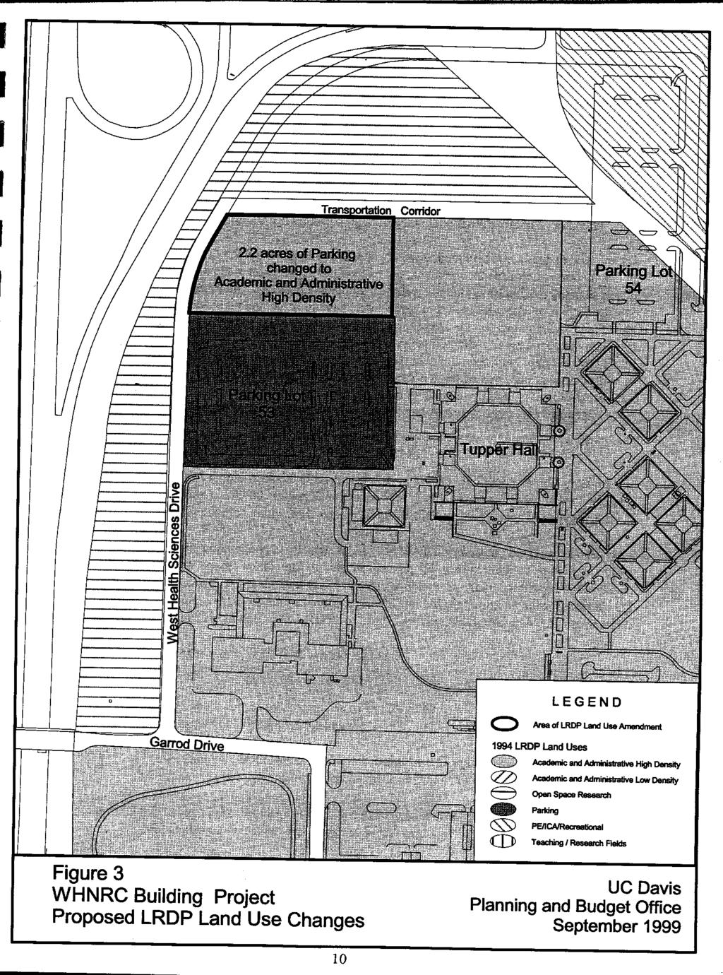
14 Land Use Designation As shown in Figure 3, approximately 2.2 acres of the 2.4 acre proposed project site is designated as Parking. In addition, the proposed project site includes an approximately 0.2 acre area identified as a Transportation Corridor in the 1994 LRDP (see Figure 3-8, Major Parking and Roadways, on page 3-18 of the 1994 LRDP DEIR). The project would require an amendment to the 1994 LRDP to change the 2.2 acres of Parking to High Density Academic and Administrative (see Figure 3). The 1994 LRDP anticipated construction of another surface parking lot to the north of Lot 53 at the proposed project site to accommodate future growth in the Health Sciences District. Based on further review, and in order to provide a viable site for construction of the WHNRC, the Campus has determined that instead of building another surface parking lot, that a parking structure or deck could be constructed on Lot 53 to accommodate future growth as part of a future project. The Transportation Corridor would not be redesignated to accommodate the proposed WHNRC because it would be within the designated building setback area and would be maintained, consistent with the 1994 LRDP, for use by pedestrians and bicyclists and would serve as a utility corridor for the proposed WHNRC. Surrounding 1994 LRDP land use designations currently include Open Space Reserve to the north and west, Parking to the south, and High Density Academic and Administrative to the east. Please see Section III for a discussion of the proposed project s general conformance with the 1994 LRDP and 1994 LRDP EIR. Background and Need for Project The USDA Agriculture Research Service s WHNRC, located at the Presidio of San Francisco since 1980, leased space from the Sixth U.S. Army until the Presidio was transferred to the National Park Service on October 1, After considering all options for relocation based both on potential costs and programmatic linkages, the USDA concluded in April 1996 that the WHNRC should be moved to the UC Davis campus. The UC Davis Campus was selected because it provides an excellent opportunity to establish productive collaborations in the fields of health and nutrition between UC Davis and USDA researchers. UC Davis has established research programs on campus in Nutrition and Food Science and Technology. Approximately 40 WHNRC employees were temporarily moved to existing campus facilities in The research mission of the WHNRC is to develop and test dietary interventions for improving the health of all Americans. The research program focuses on two prevalent nutritional problems in the United States: 1) the effect of self-imposed restricted intakes of food on nutrition and health, and 2) the impact of protective factors in foods on cardiovascular and immunological function. Maintenance of body weight is a concern to many Americans. It is not uncommon for individuals to limit their intake of food in an attempt to achieve a desired body weight. Research has shown that chronic energy restriction can impair mental and immunological function, bone function, and nutritional health. However, restricted intakes can benefit health by improving cardiovascular risk factors (i.e., glucose intolerance, more favorable lipid profiles, and reduced 9
15
16 blood pressure) or enhancing longevity. It is important, therefore, to define restricted diets that maximize the health benefits and minimize the detriments. The research program is done in five projects: (1) Diets, Antioxidants, and Optimal Health; (2) Trace Element Metabolism, Status and Requirements; (3) The Influence of Dietary Fat on Health and Immune Response; (4) Healthy Body Weight: Influences of Nutritional, Biological, and Environmental Factors; and (5) Nutrition, Infection, and Immune Disorder. The research of chronic energy restriction would take place primarily in one of the five projects included in the WHNRC research program (Healthy Body Weight: Influence of Nutritional, Biological, and Environmental Factors). An emerging frontier of nutrition is the premise that a wide variety of food components besides the essential nutrients protect health. Examples include any phytochemicals in foods (such as phytoestrogens in soybeans and limonoids in citrus) and components of food fiber (such as pectin and beta-glucans). These compounds, along with selected nutrients, are thought to reduce the risk of cardiovascular disease and cancer and enhance antioxidant status and immune function. Research at the proposed WHNRC would be undertaken to identify the active components in foods, their range of tolerable intakes, and the mechanism by which they reduce the risk of chronic disease. The research of protective factors in foods would be the joint responsibility of two of the five units included in the WHNRC research program (Diet, Antioxidants, and Optimal Health, and Trace Element Metabolism, Status and Requirements of Humans). Project Elements The proposed WHNRC would include: (1) construction of an approximately 49,000 gross square feet (gsf) (approximately 29,400 assignable square-foot (asf)) two- to three-story research laboratory building; (2) addition of approximately 60 new full-time employees to the campus; (3) relocation of 40 USDA WHNRC employees currently on the UC Davis Campus to the Health Sciences District; (4) construction of up to 25 WHNRC-reserved parking spaces and approximately 60 new spaces to the north side of Lot 53; (5) connections to existing campus utilities including electrical, domestic and utility water, wastewater, storm drainage, natural gas, chilled water and steam, and telecommunications; and (6) the redesignation of approximately 2.2 acres designated as Parking in the 1994 LRDP to High Density Academic and Administrative. Uses at the two- to three story WHNRC would include: A human studies area for both resident and non-resident studies which would include space for up to 16 subjects to live 24 hours per day in a locked/monitored environment (9,748 gsf or 5,849 asf); Non-chemical laboratories which would not involve the use of hazardous chemicals or the generation of biohazardous materials (1,280 gsf or 768 asf); Chemical laboratories which would include the use of chemicals and/or biohazardous materials (9,700 gsf or 5,820 asf); Office space (5,460 gsf or 3,276 asf); and Storage areas that could store: (1) office supplies; (2) hazardous, non-hazardous, and radioactive waste; (3) laboratory supplies, including chemicals (corrosive and flammable) and expendable supplies for use with specialized equipment; (4) dietary supplies; and (5) file storage for subjects medical records (2,100 gsf or 1,260 asf). 11
17 The facility would include approximately 2,180 gsf (1,308 asf) of miscellaneous areas for room types such as freezers, receiving, and glassware cleaning. The facility would also include service areas such as utility rooms, corridors, and lobbies. The additional parking associated with the WHNRC would be located in a new 25-space surface lot off of West Health Sciences Drive to the west of the WHNRC facility. The project would also add approximately 60 new spaces along Service Access Drive to the north side of Lot 53. The WHNRC research programs could involve the use of laboratory animals; however, the animals would not be bred or housed in the WHNRC for extended periods of time. Existing facilities at Tupper Hall and Animal Resources Services (ARS) would continue to be used for that purpose. Population The WHNRC would accommodate approximately 100 people including the relocation of approximately 60 new USDA employees from the existing WHNRC currently located at the Presidio in San Francisco to the UC Davis Campus. As of April 1999, approximately 40 WHNRC staff were located in the following buildings on Campus: Hickey Gym, Social Sciences and Humanities, Food Science and Technology, Wickson Hall, Meyer Hall, Surge 3, and Surge IV. The existing population would be relocated to the new building. Landscaping The proposed WHNRC would include the development of new landscape areas over that which currently exists. Setbacks The WHNRC would include setbacks on the east, north, south and west sides of the proposed building (see Figure 4). The setbacks on the east, south and west sides would be 30 feet from the ground lease boundary, and the northern setback would be 70 feet from the ground lease boundary. Utilities and Infrastructure The proposed WHNRC would require connections to Campus utilities and infrastructure including data communications, electrical, chilled water, steam, natural gas, domestic water, sanitary sewer, utility water, and storm drainage systems, as described below. Existing infrastructure would not need to be relocated in order to accommodate the facility. 12
18
19 Domestic Water - A domestic water loop would be installed and connected to an existing eight-inch distribution line along West Health Sciences Drive. Utility Water - Utility water would be provided to the proposed WHNRC through a new distribution line currently running north/south under West Health Sciences Drive. Chilled Water - The proposed WHNRC would be connected to existing chilled water distribution lines located underground at the southwest corner of Parking Lot 54. Steam - The proposed WHNRC would be connected to existing steam distribution lines located underground just south of Parking Lot 54. Sanitary Sewer - A new sanitary sewer line would be installed underground along the north side of the proposed WHNRC under the transportation corridor and would be connected to existing sewer lines north of Tupper Hall. Storm Drainage - The proposed WHNRC would be connected to existing storm drainage lines located under West Health Sciences Drive. Electrical - A new electrical loop would be constructed underground along the north side of the proposed WHNRC under the transportation corridor and would be connected to an existing electrical line located underground just northeast of Tupper Hall. Natural Gas - The proposed WHNRC would connect to an existing natural gas main located along West Health Sciences Drive. Telecommunications - The proposed WHNRC would connect to an existing communication line colocated in the basement of Med Sci 1A and Tupper Hall. The provision of services would require connection to existing Campus systems which would include extending existing facilities, but would not require expansion of existing facilities, with the exception of telecommunications. All points of connection would be adequate with the completion of previously approved utilities upgrades, including the 1999 Chilled Water Expansion Project (Phase IV), construction of a new WWTP, and the Electrical Improvements Phase 2B project. Roadway and Parking Improvements The proposed WHNRC does not include changes to the existing roadway system in the project area and would add parking to the area. Access to the site would be from the existing West Health Sciences Drive and parking would be provided from the existing Parking Lots 53 and 54, along West Health Sciences Drive, and from a new parking lot directly to the west of the new facility. The new parking lot would provide approximately 25 additional spaces. Parking in these spaces would be controlled by the USDA and would not be available to the general campus community. Striping, signage, and possibly a security gate would be implemented. In addition, to accommodate increased demand for parking by the WHNRC, the overall project includes expanding Parking Lot 53 to include 60 new parking spaces along the Service Access Drive for WHNRC. 14
20 Project Schedule The ground-lease for construction of the WHNRC in the Health Sciences District is expected to be signed by the Office of the President and USDA in November Currently, the WHNRC project is scheduled for approval by the Regents in Summer 2000, with construction in Winter 2002, and completion of construction by Winter of Construction Staging Construction staging would take place on-site on currently undeveloped land immediately west of the proposed WHNRC (see Figure 4). Construction traffic would access the site from SR 113 and Hutchison Drive. Because the construction site is in close proximity to Tupper Hall and there would be potential for indoor air quality complaints during construction, control measures would be implemented for local NO x and ROC control. (See Item 5 of the Environmental Checklist for a discussion of this issue.) Project Objectives The Campus identified the following objectives for the proposed WHNRC: Provide a facility to house the WHNRC program that meets the requirements of the USDA; Locate similar use facilities in close proximity to existing buildings in the Health Sciences Complex; Establish linkages between the WHNRC and the UC Davis Departments of Nutrition and Food Science and Technology, the School of Medicine, and other similar campus programs for an innovative, world-class program in food for health research programs; Create an image to outside, as well as campus, community; Create a direct access to and from buildings for potentially 24 visitors and company/day; Create access to Tupper Hall and associated services; Create access to School of Medicine imaging equipment; and Identify utility capacity/adequacy for complete buildout. Project Approval As a public agency principally responsible for approving or carrying out the proposed project, the University of California is considered the Lead Agency under CEQA, and is responsible for reviewing and certifying the adequacy of the environmental document and approving the proposed USDA WHNRC. The USDA and the University of California Office of the President will sign the ground lease following completion of the environmental review (November 1999). It is anticipated that The Regents will consider design approval of the proposed WHNRC in Summer The USDA is the 15
21 lead agency to the WHNRC under the National Environmental Policy Act (NEPA) and is responsible for reviewing and certifying the adequacy of the federal environmental document and approving the WHNRC. Separate documentation is being prepared for the WHNRC for consideration of certification by the USDA consistent with NEPA requirements. 16
22 III. CONSISTENCY WITH 1994 LRDP AND LRDP EIR Introduction In order to determine consistency of the proposed project with the 1994 LRDP and LRDP EIR, the following questions must be answered: Is the proposed project included in the scope of the development projected for the 1994 LRDP? Is the proposed location of the project in an area designated for this type of use in the 1994 LRDP? Are changes to Campus population that would result from the proposed project included within the scope of the 1994 LRDP population projections? Is the proposed project within the scope of the cumulative analysis in the 1994 LRDP EIR? Are the objectives of the proposed project consistent with the adopted objectives for the 1994 LRDP? The following discussion describes the WHNRC s relationship to development projections, land use designations, population projections, and objectives contained in the 1994 LRDP, and the project's consistency with each of these items LRDP Scope of Development The 1994 LRDP approved development of approximately 1.75 million asf for academic and administrative uses, support, libraries and student services. Since adoption of the 1994 LRDP, approximately 429,686 asf has been approved, constructed, or occupied. Table 1 provides a breakdown of the building space inventory for the Campus buildout. Even though the WHNRC is a federal facility, it still counts toward development of Instruction and Research space anticipated under the 1994 LRDP. Therefore, the additional approximately 29,400 asf for the USDA WHNRC of Instruction and Research space resulting from the proposed project would not exceed planned development and would be consistent with the development approved under the 1994 LRDP LRDP Land Use Designations As shown in Figure 3, 2.2 acres of the 2.4-acre proposed WHNRC site is designated as Parking under the 1994 LRDP. In addition, the proposed project site includes an approximately 0.2-acre area identified as a Transportation Corridor in the 1994 LRDP (see Figure 3-8, Major Parking and Roadways, on page 3-18 of the 1994 LRDP DEIR). The 1994 LRDP defines the High Density Academic and Administrative land use designation as follows (see pages 45 and 46 of the 1994 LRDP): 17
23
24 This land use category includes space for conducting the instruction and research mission of the University of California. Classrooms; research laboratories and research support areas including animal facilities; faculty, student and staff offices; and libraries make up the majority of this space. Also included is space for student activities, museums, administrative offices, meeting rooms, and space for public service activities linked to UC Davis. The high density designation includes existing buildings up to nine stories, and an average height for new buildings of four stories. The proposed project would include construction of a new facility in the Health Sciences District on the Central Campus to provide research and administrative facilities for the USDA (Agricultural Research Service). The proposed WHNRC would be two to three stories in height. Therefore, the proposed WHNRC would be consistent with the High Density Academic and Administrative land use designation. The 1994 LRDP defines the Parking land use designation as follows (see page 47 of the 1994 LRDP): Major surface parking lots and parking structures are included in this land use. Existing and future infill parking lots of less than 100 spaces are subsumed in other land use categories and are not shown on the plan. The proposed WHNRC project would include redesignating approximately 2.2 acres of Parking as High Density Academic and Administrative. The redesignation of this land use would require an LRDP amendment to revise the proposed WHNRC site from Parking to High Density Academic and Administrative. The 1994 LRDP anticipated construction of another surface parking lot to the north of Lot 53 at the proposed project site to accommodate future growth in the Health Sciences District. Based on further review, and in order to provide a viable site for construction of the WHNRC, the Campus has determined that instead of building another surface parking lot, that a parking structure or deck could be constructed on Lot 53 to accommodate future growth as part of a future project. The WHNRC would not require an amendment to the 1994 LRDP to redesignate the Transportation Corridor because it would be within the designated building setback area and would be maintained, consistent with the 1994 LRDP, for use by pedestrians and bicyclist and would serve as a utility corridor for the proposed WHNRC LRDP Population Projections The 1994 LRDP DEIR (pages 3-2 and 3-3) described the following regarding Campus population projections. Population projections for all campuses in the UC system are established in a process that is determined by State statute and policy. The specific campus population projections for UC Davis are determined by the Campus and the Office of the President, which consider: the responsibility of the University as required by the State Master Plan for Higher Education to accommodate the top 12.5 percent of graduating high school students in the University of California system; the state's ability to support financially this policy commitment; population growth and specifically the number of qualified students; and the academic plan and physical capacity of the Davis campus to accommodate students. 19
25 Table 2 summarizes the anticipated population growth under the 1994 LRDP. As shown in Table 2, population estimates ( ) for Campus faculty, staff and students is 32,982 (22,803 students and 10,179 faculty and staff). Recently, the Regents approved the Major Capital Improvement Projects, which will add approximately 62 faculty and staff to the estimates, and the Center for the Arts Performance Hall and South Entry Roadway and Parking Improvements Project, which will add approximately 10 new campus employees. The Campus also recently approved the 1999 Chilled Water Expansion Project, which will add up to three new employees. With these three projects, the total campus faculty and staff population would be 10,251. The addition of up to 100 new employees associated with the proposed WHNRC (even though it is a federal facility, the new population associated with the WHNRC counts towards the population increase anticipated under the 1994 LRDP) for a total of 10,351 employees would not exceed the population projections (12,630 faculty and staff), assumed in the 1994 LRDP. Therefore, the proposed project would be consistent with 1994 LRDP population projections. TABLE 2 PROJECTED CAMPUS POPULATION Population Students 1 21,060 22,803 26,000 Faculty and staff 2 9,550 10,179 12,630 TOTAL POPULATION 30,610 32,982 38, Off-campus student population not counted in this total. Approximately 570 students are located at the UC Davis, Medical Center, Sacramento, Campus and an additional 280 students are enrolled elsewhere at other UC Davis affiliated facilities. Therefore, accounting for the off-campus student population, total UC Davis enrollment in will be 26, Includes faculty and staff located on the Central, West and South Campus, Russell Ranch and at Campus facilities in the City of Davis sphere of influence. 3. Base year for 1994 LRDP EIR analysis. 4. Most recent population figures. 5. Projected 1994 LRDP buildout. SOURCES: Table 3-1 on page 3-3 of the 1994 LRDP DEIR, UC Davis Planning and Budget Office, EIP Associates, 1993, 1995, and LRDP EIR Cumulative Analysis The 1994 LRDP EIR contained cumulative analyses for the projected buildout of the UC Davis LRDP. The cumulative context in the 1994 LRDP EIR varied depending on the nature of the issue being studied. Cumulative effects were classified by natural resources boundaries (i.e., biological resources, hydrology, geology, and air quality); and those defined by population growth within the City of Davis, and Yolo and Solano counties (i.e., public and community services, transportation, hazardous materials, noise, visual and cultural resources). The cumulative impact analysis for each technical issue in the EIR was defined based on the cumulative context that best defined the extent of the possible cumulative effect (see Section 5.2, Cumulative Impacts, of the 1994 LRDP EIR). The proposed project includes construction and operation of a new facility in the Health Sciences District. As discussed above, the proposed WHNRC is consistent with the 1994 LRDP scope of 20
26 development for development of High Density Academic and Administrative use and population projects for buildout through Therefore, the proposed project incrementally contributes to, but does not exceed the cumulative impact evaluation contained in the 1994 LRDP EIR, as amended. Since adoption of the 1994 LRDP, the anticipated amount of development in the Health Sciences District has been refined. In addition to the proposed WHNRC building, probable growth in the Health Sciences District is anticipated to include four new buildings associated with the Veterinary School (Surgeries Relocation, Center for Companion Animal Health, Vet Med 3A, and the Valley Building), and one building associated with the School of Medicine (Center for Functional Genomics and Bioinfomatics) for a total of approximately 320,000 asf. Although this growth represents a redistribution of asf to the Health Sciences District that differs from the assumptions made in the LRDP EIR analyses, it is still consistent with overall approved LRDP asf and population projections for the campus. Assumptions for the LRDP are periodically refined as the LRDP is implemented. This refinement of assumptions for growth in the Health Sciences District has been incorporated into the updated cumulative health risk assessment and traffic analysis for this project. In order to accurately reflect probable growth in the Health Sciences District, the five projects mentioned above have been included in the cumulative impact analysis for the proposed project. Specifically, please see the discussions under Items 6 -Air Quality, 7 -Transportation/Circulation, and 13-Utilities and Service Systems. The technical discussions in the Tiered Initial Study Checklist concluded that the proposed project would: (1) not contribute to significant and unavoidable cumulative impacts identified in the 1994 LRDP EIR related to loss of prime agricultural land (see Item 2a), and exposure to existing hazardous materials during construction (see Item 10a); ( 2) incrementally contribute to (a de minimis contribution), but not exceed, significant and unavoidable impacts identified in the 1994 LRDP EIR related to seismic groundshaking (see Item 4a), post-construction water quality (see Item 5a), loss of groundwater recharge potential (see Item 5b), criteria and toxic air emissions (see Item 6a,b,f), intersection level of service (see Item 7a), loss of Annual Grassland habitat (see Item 8a,b,e), hazardous materials use (see Item 10b), radioactive materials use (see Item 10c), biohazardous materials use (see Item 10d), emergency response (see Item 10h), noise levels (see Item 11a), fire protection services (see Item 12a), police protection services (see Item 12b), contribution of school age children to the Davis Joint Unified School District (see Item 12c), demand from the deep aquifer (see Item 13f), loss of rural character (see Item 14a-c), and loss of cultural resources (see Item 15c,e); and (3) incrementally contribute to (a de minimis contribution), but not exceed, less-than-significant cumulative impacts identified in the 1994 LRDP EIR related to carbon monoxide emissions (see Item 6a,b,f), transport of hazardous materials (see Item 10f), parks and recreation demand (see Items 12d and 16b), electricity and natural gas demand (see Item 13a), wastewater capacity (see Item 13c,d,g), demand from the shallow/intermediate aquifer (see Item 13f), and solid waste disposal capacity (see Item 13h) LRDP Objectives 21
27 As described on page 3-10 of the 1994 LRDP DEIR, among other goals, the 1994 LRDP was intended to meet the needs of anticipated growth in enrollment and employment by providing expanded instruction and research space. More specifically, the 1994 LRDP contains the following objectives that are applicable to the proposed project: Building space. Manage existing building space to provide sufficient and suitable space for existing and evolving campus programs. Location of programs. Cluster related academic and administrative programs geographically when feasible, to facilitate academic interaction. Central Campus. Concentrate high density academic development on the Central Campus. A compact core campus. Maintain the academic core for instruction and research facilities, generally within a 10-minute walk from Shields Library. Maintain building density targets in the core campus, with an average height of four stories for new development. Use the infill of new buildings and the removal of outmoded facilities as opportunities to continue the development of common open spaces as initiated in the 1963 plan. Bicycle and pedestrian systems. Accompany new development, particularly in the Central Campus, with appropriate additions to the bicycle and pedestrian systems. Future corridors. Preserve flexibility beyond the life of the plan by keeping new buildings clear of potential roadway and bikeway corridors. The proposed project would be consistent with the objectives contained in the 1994 LRDP. The proposed WHNRC would cluster related programs in the Health Sciences District of the Central Campus. The facility would maintain building density targets in the Central Campus. Finally, the WHNRC would include expansion of the existing pedestrian plaza in the Health Sciences District adjacent to Tupper Hall. The designated Future Transportation Corridor would be accommodated by the building setback requirements and would be maintained. Therefore, the proposed WHNRC would be consistent with the applicable objectives contained in the 1994 LRDP. 22
28 IV. TIERED ENVIRONMENTAL CHECKLIST Introduction The Checklist form is used to assist in evaluating the potential environmental impacts of the proposed project with respect to the 1994 LRDP EIR. The Checklist form identifies potential project effects as follows: (1) new potentially significant project impacts that were not adequately analyzed in the 1994 LRDP EIR, or previously identified significant impacts for which new feasible mitigation measures are available; (2) new less-than-significant impacts; (3) environmental impacts of the project that were adequately analyzed and mitigated in the 1994 LRDP EIR; and (4) effects that would not result in any adverse environmental impact. A discussion follows each environmental item identified in the Checklist. Included in each discussion are 1994 LRDP EIR mitigation measures, as appropriate, recommended for implementation as part of the proposed projects. Issues 1. LAND USE AND PLANNING. Would the proposal: Significant Impact/New Mitigation Required New Less Than Significant Impact Impact for Which 1994 LRDP EIR is Sufficient a. Physically divide an established community? b. Conflict with designated adjacent existing or future land uses on or off-campus? c. Be in general conformance with LRDP land use designations? d. Conflict with any applicable habitat conservation plan or natural communities conservation plan? No Impact * * This new potentially significant project-specific impact is reduced to a less than significant level by mitigation measure(s) included in this Tiered Initial Study. Discussion Land use issues are addressed in Section 4.1 of the 1994 LRDP DEIR, as amended by the LRDP FEIR, in Section 4.6 of the 1997 WWTP Replacement Project DEIR, as amended by the WWTP FEIR, in Sections 5.3, 6.3, 7.3 and Chapter 8 of the Major Capital Improvement Projects DSEIR, as amended by the FSEIR, and Item 1 of the Center for the Arts Tiered Initial Study and Mitigated Negative Declaration, as amended by the Final Initial Study and Mitigated Negative Declaration. a) The proposed project includes development in the Health Sciences District of the Central Campus. Implementation of the proposed project would not disrupt or divide the physical arrangement of an established community. Therefore, no impact would occur. 23
29 b) The approximately 2.4-acre undeveloped site is located in the Health Sciences District of the Central Campus just east of West Health Sciences Drive, north of Parking Lot 53, and northwest of Tupper Hall. Existing adjacent land uses include undeveloped Open Space and Open Space Reserve to the north and the immediate west, a parking lot to the south, and High Density Academic and Administrative to the west. Surrounding 1994 LRDP land use designations include Open Space Reserve to the north and west, Parking to the south, and High Density Academic and Administrative to the east and southeast. The proposed facility would include development of the proposed WHNRC, landscaping and associated parking facilities which would be consistent with adjacent High Density and Academic and Parking land uses. Therefore, implementation of the proposed WHNRC would not be anticipated to conflict with adjacent on or off campus existing and/or future uses. This impact is less than significant and no mitigation is required. c) As previously described, approximately 2.2 acres of the 2.4-acre proposed WHNRC site is designated as Parking in the 1994 LRDP. In addition, the proposed project site includes an approximately 0.2 acre Transportation Corridor. In order to accommodate the proposed WHNRC facility, approximately 2.2 acres of Parking would be redesignated as High Density Academic and Administrative which would require a LRDP amendment. The 1994 LRDP anticipated construction of another surface parking lot to the north of Lot 53 at the proposed object site to accommodate future growth in the Health Sciences District. Based on further review, and in order to provide a viable site for the construction of the WHNRC, the Campus has determined that instead of building another surface parking lot, that a parking structure or deck could be constructed on Lot 53 to accommodate future growth as part of a future project. Redestination of the proposed project site land use with an LRDP amendment is considered a significant impact unless mitigation is incorporated. Implementation of the following project-specific mitigation measure would reduce this impact to a less-than-significant level. Project-Specific Mitigation Measure 1. The Regents shall amend the 1994 LRDP land use map to change 2.2 acres of the proposed WHNRC site from Parking to High Density Academic and Administrative land use designation. The redesignation of approximately 2.2 acres of Parking to High Density Academic and Administrative use would not result in insufficient parking capacity in the Heath Sciences District because a separate element of the overall project includes expanding Parking Lot 53 along Access Service Drive to add 60 new parking spaces. In addition, it is anticipated that a future project would include construction of a parking structure or deck on Lot 53 (see the discussion above and under Item 7d). The Transportation Corridor would not be redesignated to accommodate the proposed WHNRC because it would be within the designated building setback area and would be maintained, consistent with the 1994 LRDP, for use by pedestrians and bicyclists and would serve as a utility corridor for the proposed WHNRC. 24
30 d) The approximately 2.4-acre WHNRC site is currently undeveloped land located in a developed portion of the Campus designated as Urban and Built-up Land by the State of California Department of Conservation for Yolo and Solano Counties Important Farmlands Map (see Figure on page of LRDP DEIR). The proposed project site is not included in any conservation plan. Therefore, the proposed WHNRC would not conflict with any applicable habitat conservation plan or natural communities conservation plan, and no impact would occur. Summary The proposed WHNRC would not result in any new or significant impacts associated with disruption of an established community, conflicts with designated adjacent existing or future land uses on or offcampus or applicable habitat conservation plans or natural communities conservation plans. The proposed WHNRC would be inconsistent with 1994 LRDP land use designations, and Project-Specific Mitigation Measure 1 will be implemented as part of the project to reduce this impact to a less-thansignificant level. This project-specific impact is less than significant after mitigation. No additional mitigation is required. Issues 2. AGRICULTURE RESOURCES: Would the proposal: a. Convert Prime Farmland, Unique Farmland, or Farmland of Statewide Importance (Farmland) to nonagricultural use? b. Conflict with existing zoning for agricultural use, or a Williamson Act contract? c. Involve other changes in the existing environment which, due to their location or nature, could individually or cumulatively result in loss of farmland, to non-agricultural use? Significant Impact/New Mitigation Required New Less Than Significant Impact Impact for Which 1994 LRDP EIR is Sufficient No Impact Discussion a) The approximately 2.4-acre WHNRC site is currently undeveloped land designated as Urban and Built-up Land by the State of California Department of Conservation for Yolo and Solano Counties Important Farmlands Map (see Figure on page of LRDP DEIR). The proposed WHNRC site is not designated as prime farmland by the State Department of Conservation s inventory, and therefore, would not result in the loss of prime farmland, unique farmland, or farmland of statewide importance. No impact would occur. Cumulative Impacts The 1994 LRDP, as amended, concluded that development under the 1994 LRDP and in the region could covert approximately 1,229 acres of prime agricultural lands to urban uses. This impact was considered significant and unavoidable and was fully addressed by the Findings and 25