Minnesota EAW Supplement
|
|
|
- Phyllis Cannon
- 5 years ago
- Views:
Transcription
1 Appendix I: Minnesota EAW Supplement Lower Pool 2 Channel Management Study: Boulanger Bend to Lock and Dam No. 2
2 Minnesota EAW Item Identification A supplement prepared for the Minnesota DNR to identify locations of EAW Items within the Letter Report and Integrated Environmental Assessment 1. Project Title: Lower Pool 2 Channel Management Study: Boulanger Bend to Lock and Dam No Proposer U.S. Army Corps of Engineers Contact Person: Aaron McFarlane Biologist St. Paul District, U.S. Army Corps of Engineers 180 Fifth Street East, Suite 700 Saint Paul, MN Telephone: aaron.m.mcfarlane@usace.army.mil 3. RGU Minnesota Department of Natural Resources 4. Reason for EAW Preparation Mandatory EAW 5. Project Location See Chapter 1.2, Figure 3, and attached Topo Map (Exhibit 1) County: Dakota and Washington Counties, Minnesota City/Township: Cottage Grove and Nininger Township Watershed: HUC-8 = GPS (NAD83, UTM Zone 15N, meters): West Structure Center: 505,134.4 E; 4,957,893.6 N East Structure Center: 506,314.4 E; 4,958,687.4 N Channel Dredging (west): 503,059.7 E; 4,957,223.0 N Channel Dredging (east): 507,048.3 E; 4,957,885.8 N Placement Location: 502,527.9 E; 4,958,231.1 N Tax Parcel IDs: Dredged Material Placement Site: Rock Sill Structure multiple parcels, shown on Exhibit 2 PLSS Sections within footprint: Dakota T115, R18 W Sections 11, 12, 13, 14 Washington T27, R21 W Sections 33, 34 PLSS Sections at placement site: Washington T27 R21 Sec 30, SE1/4-SE1/4 & W1/2-SE1/4 I-2 Appendix I Minnesota EAW Supplement
3 6. Project Description a. EQB Monitor Summary The U.S. Army Corps of Engineers, St. Paul District is proposing to construct two new channel training structures in Lower Pool 2 of the Mississippi River near Hastings, Minnesota to improve navigability and safety by helping to maintain the full congressionally-authorized channel width. b. Full summary Ch. 5.6 c. Project Magnitude Total Acreage Directly Impacted: Rock Structure footprint: 6.3 Acres Approximate dredging footprint: 27 acres Approximate placement footprint: Up to 75 acres Others N/A d. Project Purpose Chapter 1.3, with additional details in Chapter 3.2 The project would provide benefits to the U.S. Army Corps of Engineers in improving the ability to maintain the 9 Foot Navigation Channel Project; the U.S. Coast Guard in improving the ability to maintain Aids to Navigation; the commercial navigation industry by allowing larger tows; and the recreating public by improving safety of navigating in the main channel. e. Future Stages None planned. Related studies and reports listed in Chapter 1.4. f. Is this a subsequent stage No, but part of the ongoing management of the Nine-Foot Navigation Channel Project. The St. Paul District Corps of Engineers maintains a 9 footdeep navigation channel on the Mississippi River from Minneapolis, MN to Guttenberg, IA using a combination of lock-and-dams, channel training structures, and annual maintenance dredging. The navigation channel facilitates a variety of commercial and recreational transportation. See Sections 1.1 & Cover Types Ch , specifically Figure 6-3. The table from the figure that identifies the change in habitat types resulting from the project is copied below for convenience, but Figure 6-3 also identifies these areas on a map. Habitat Type Change in Acres Impounded Floodplain Shallow Aquatic Main Channel Main Channel Border Revetment Wing Dam Secondary Channel 0 Land 0 Contiguous Impounded Floodplain Lake 0 Appendix I Minnesota EAW Supplement I-3
4 8. Permits and Approvals Required Chapter 7 9. Land Use a. Describe: i. Existing Land Use Ch. 2.1 ii. Planned Land use Ch iii. Zoning Ch b. Compatibility with nearby land uses Ch c. Identify land use compatibility mitigation Since no land use incompatibilities were identified, no mitigation has been proposed. 10. Geology, soils, and topography/landforms a. Geology 2.2.1, 6.2.1, Appendix J Geotechnical Report b. Soil and topography Appendix J Geotechnical Report 11. Water Resources a. Features i. Surface Water The proposed project would take place in Lower Navigation Pool 2 of the Mississippi River (Public Water Inventory: U.S. Lock & Dam #2 Pool 19-5 P ). This waterbody is listed by the MPCA as having an approved TMDL Plan for Mercury in Fish Tissue; Mercury in Water Column, and Additional Impairments of PCB in Fish Tissue, PFOS in Fish Tissue, and Turbidity. The area is part of the MNRRA. The project area is not a designated wild, scenic, or recreational river segment. The Lower St. Croix River, designated as a recreational river segment, flows into the Mississippi River 6.5 river miles downstream, beyond Lock and Dam No. 2. There are no designated Wildlife Lakes in Dakota or Washington Counties, no designated trout lakes or streams are in the project vicinity, and no calcareous fens identified in project vicinity. Other water resources in the project area (Shown on Exhibits 3 and 4) include several unnamed streams, several named features of the Mississippi River (e.g., Spring Lake, Grey Cloud Slough, etc.), and several wetlands. The St. Croix River flows into the Mississippi River approximately 6.5 miles downstream of the project area, and appx. 3.5 river miles downstream of the proposed staging area at Lock and Dam 2. Additional descriptions of the surface water features directly impacted by the proposed project can be found in the report, in Section : Hydrology & Hydraulics; and Section 2.2.8: Water quality. I-4 Appendix I Minnesota EAW Supplement
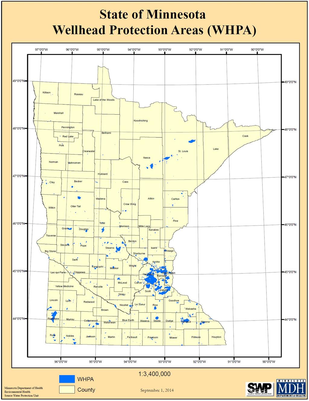
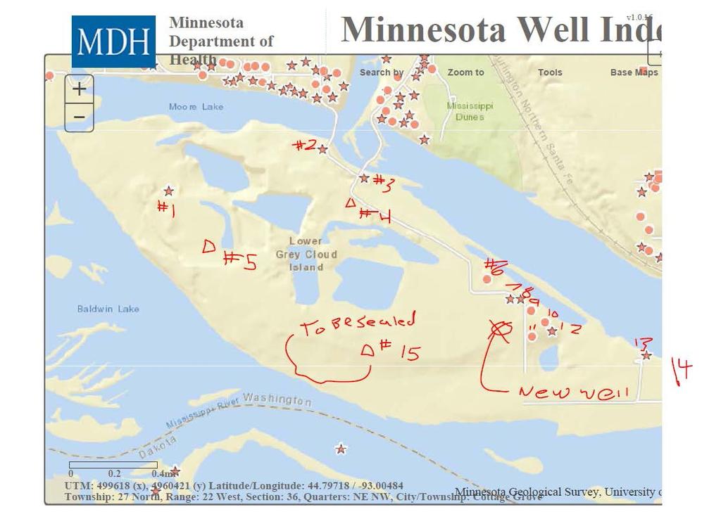
5 ii. Groundwater No groundwater impacts are expected. The following considerations contributed to this determination: 1. Depth to groundwater at the proposed placement site would be 0-feet as material will be placed into a ground water filled mine. 2. Depth to groundwater at the proposed staging site is 10 Feet. One well is located near the staging area at Lock and Dam #2 (Well # ), and is located approximately 850-feet away from the proposed staging area. 3. The project and staging areas are not within a WHPA (wellhead protection area) as of The map in Exhibit 5 shows the wellhead protection areas on September 1, Waters within the mine are separated from the surrounding watershed by the Mississippi River and Moore Lake. The Mine is located within the Quaternary aquifer, wells on the banks of the river are finished within the bedrock aquifer so there is little concern of contamination. There are sixteen known wells on lower Gray Cloud Island, as identified on Exhibit 6. Three of the wells are Corps of Engineers monitoring wells. The well labeled 15 on Exhibit 6 is to be sealed, and will be replaced with a new well by the group of wells on the shore of Moore Lake. Most wells on the island are finished within the Quaternary aquifer within the depth of the mined material. A monitoring program will need to be established prior to placement of any material to obtain background base levels. b. Effects from project activities i. Wastewater N/A No wastewater is associated with the project. ii. Stormwater N/A No stormwater impacts would be expected, as the project is to be constructed within a water body. iii. Water Appropriation N/A The project will not involve water use. iv. Surface Waters a) Wetland alterations No wetlands are known to exist in the project area. See report sections: Existing: 2.2.6; Effects: b) Other Surface Waters This project would involve the placement of fill in public waters. Ch. 5.6 describes the proposed project features and some of the best management practices that would be implemented. Environmental effects of the proposed actions are discussed in Chapter 6, organized by resource. Geomorphology and Hydrology and Hydraulic impacts are discussed in Effects on Aquatic Habitat are discussed in Appendix I Minnesota EAW Supplement I-5
6 Effects on Water quality are addressed in These effects are also discussed in the Clean Water Act 404(b)(1) analysis in Appendix B. 12. Contamination/Hazardous Materials/Wastes a. Pre-project conditions Ch b. Project-related generation of solid wastes Ch The material dredged as a part of this project for the purposes of restoring the main navigation channel would be placed at an upland site that will be also be utilized for placement of future material dredged from the maintenance of the navigation channel. Planning for that site is proceeding concurrently as the Pool 2 Dredged Material Management Plan. The site or sites utilized will be evaluated for environmental effects etc. under that planning process. c. Project-related use/storage of hazardous materials The only expected hazardous materials to be used during construction would be fuels and oils for construction equipment. As part of the Corps contracting procedure, any contractor would be required to prepare and submit for approval a spill prevention and control plan for these materials prior to construction. d. Project-related generation/storage of hazardous wastes No hazardous waste expected to be stored or generated during project construction or operation. 13. Fish, wildlife, plant communities, and rare features a. Fish, wildlife, habitat, and vegetation Ch. 2.2, 6.2 b. Rare features Ch , Heritage Database License Agreement Number: LA-768 Information in the report regarding species listed by the State of Minnesota as endangered, threatened, or special concern was compiled using the Minnesota Natural Heritage Information System (NHIS) dataset. The following steps were conducted to locate potentially-affected rare species within the project area using the newest available NHIS layer (January 12, 2016) in ESRI ArcMAP: (1) A shapefile delineating a one-mile buffer around the proposed project area was created. (2) The Select by Location tool was used to select all polygons within the NHIS shapefile which intersected the buffered project area shapefile. (3) A list of unique species listed as endangered, threatened, or special concern with recorded Element Occurrences selected by this operation was recorded in Chapter of the main report. (4) The metadata for records was examined and the results compared with the results of all available recent surveys of Lower Pool 2 to determine which species are likely to be extant within Lower Pool 2, and therefore potentially within the project footprint. Recent propagation efforts for freshwater mussels were also considered. I-6 Appendix I Minnesota EAW Supplement
7 c. Effects Ch. 6.2 d. Avoidance, minimization, and mitigation of effects Ch. 5.6, Appendix G Mussel Mitigation 14. Historic properties 2.3, 6.3; Concurrence letter from State Historic Preservation Office included as Exhibit Visual , Air a. Stationary source emissions - N/A b. Vehicle emissions , c. Dust and Odors , Noise 2.1, Transportation No transportation impacts are expected during construction or operation of the proposed project. 19. Cumulative potential effects Information from EA Item 6.4 used in the development of this section a. Describe the geographic scales and timeframes of the project related environmental effects that could combine with other environmental effects resulting in cumulative potential effects. Anticipated environmental effects of the project include surface water effects, water quality effects, effects on aquatic wildlife, visual effects, and air effects. Additionally, short-term air and noise effects are anticipated associated with the construction of the project. The geographic scale for all environmental effects are expected to limited to an area immediately surrounding the project site. The anticipated timeframes of environmental effects will be short-term for construction related air and noise effects, and would conclude at completion of the project, which would occur no later than summer The timeframes of environmental effects resulting from the project are anticipated to occur for the life of the project, which the Corps estimated to be 40 years. b. Describe any reasonably foreseeable future projects (for which a basis of expectation has been laid) that may interact with environmental effects of the proposed project within the geographic scales and timeframes identified above. While the Corps included several ongoing management plans and potential future projects, DNR is aware of one project that meet the standard of reasonably foreseeable future projects for which a basis of expectation has been laid. This project is the Proposed Nelson Mine Expansion, described in the EA on page 99. Appendix I Minnesota EAW Supplement I-7
8 c. Discuss the nature of the cumulative potential effects and summarize any other available information relevant to determining whether there is potential for significant environmental effects due to these cumulative effects. Short-term air and noise effects associated with the construction of the project are expected to have limited potential for cumulative effects due to the minor incremental increases of these effects during the project activities. Potential cumulative effects to surface waters, water quality, aquatic wildlife, visual and air effects from the project in combination with the other reasonably foreseeable future projects are discussed on pages 99 through 101 of the EA under the following headings: Recreation, Aesthetic Values, Hydrology, Hydraulics and Sediment Transport, Mussels, and Water Quality. 20. Other potential environmental effects - N/A I-8 Appendix I Minnesota EAW Supplement

9 Exhibit 9 Appendix I Minnesota EAW Supplement I-9
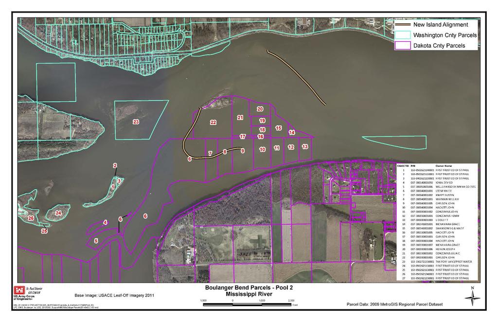
10 Exhibit 2
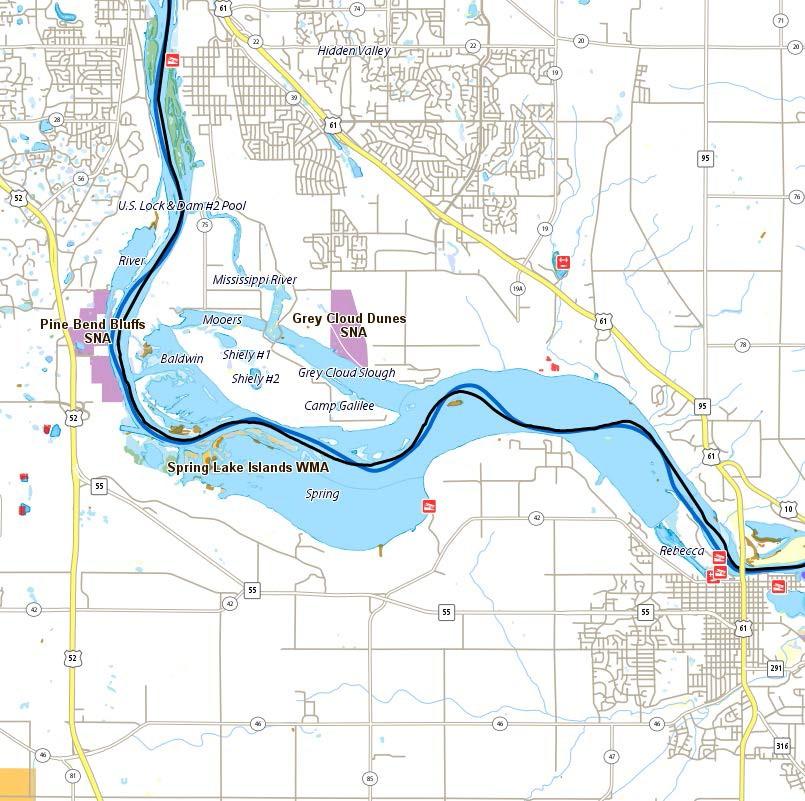
11 Exhibit 3
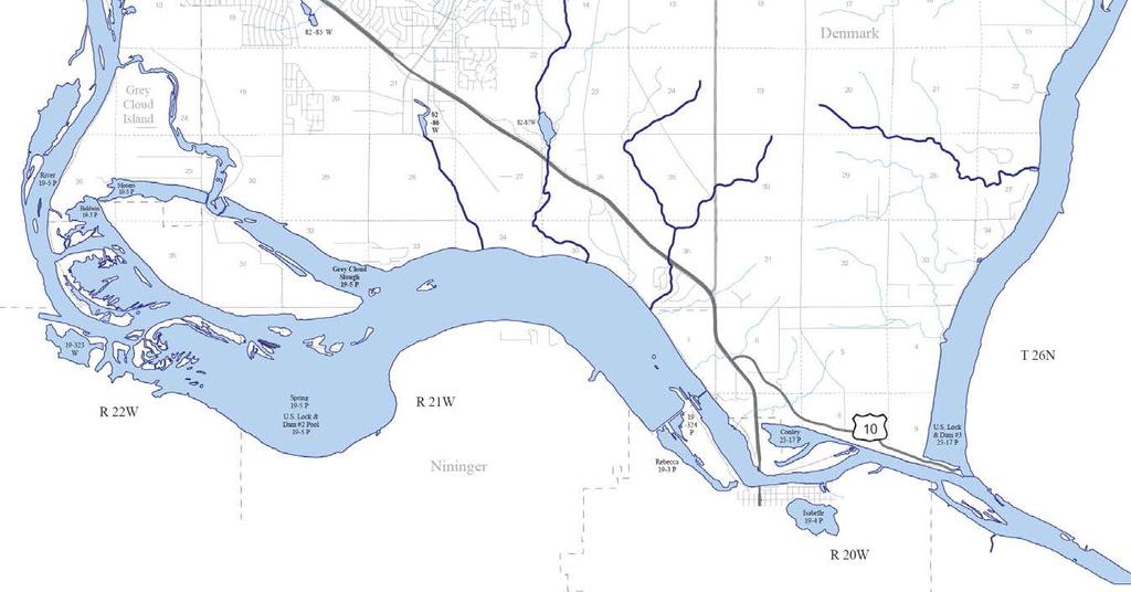
12 Exhibit 4
13 Exhibit 5
14 Exhibit 6
15 Exhibit 7