THE CADIZ VALLEY WATER CONSERVATION, RECOVERY, AND STORAGE PROJECT
|
|
|
- Marcia Flowers
- 5 years ago
- Views:
Transcription
1 THE CADIZ VALLEY WATER CONSERVATION, RECOVERY, AND STORAGE PROJECT Terry Foreman, PG, CHg, TLF Consulting, LLC Dr. Dennis Williams, PHD, PG, CHg, Geoscience Support Services, Inc. Dr. Miles Kenney, PHD, PG, Kenney Geoscience, Inc. Scott Slater, Cadiz, Inc. 16 th Biennial Symposium on Managed Aquifer Recharge March 6-7, 2018 San Diego, California Groundwater Resources Association of California and Arizona Hydrological Society

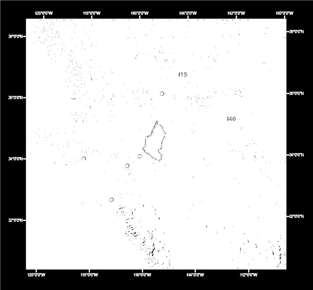
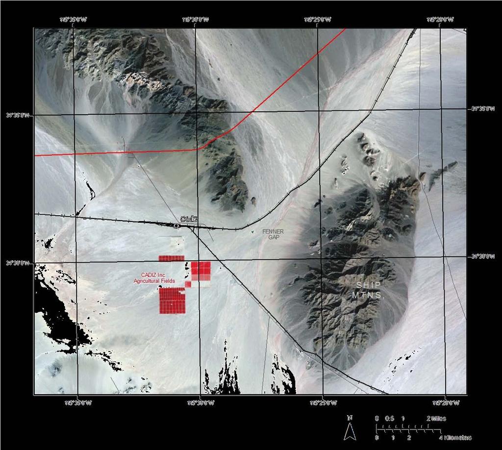
2 Location Map

3 Phase 1 Pumping Plan WATERSHED Objective: To maximize conservation of groundwater that would otherwise flow to the dry lakes and evaporate shift the pumping from the dry lakes to the wellfield for BRISTOL DRY LAKE beneficial use CADIZ DRY LAKE
4 Phase 1 Pumping Plan cont. Two components Natural recharge Groundwater already in transit to dry lakes beyond wellfield Pump 50,000 AFY to capture both components Project to be permitted for 50 years, so pumping levels will be revisited

5 Proposed Cadiz Wellfield

6 Groundwater Storage 16.9 to 34.1 Million Acre- Feet of Groundwater In Storage In Alluvium


7 Assessment of Recoverable Water Groundwater Recharge Upgradient of Project Area Topography Precipitation/ Temperature Soils Geology Vegetation


8 Modeled Recoverable Water Fenner Watershed ~30,200 AFY Orange Blossom area ~2,200 AFY


9 Evaporation Study of Dry Lakes Close the Water Budget EC Instrumentation Engaged the Desert Research Institute (DRI) to measure evaporation The from Cadiz Valley Water dry Conservation, lakes Recovery, and Storage Project
10 Results Annual Evaporation Bristol 7,860 AFY Cadiz 23,730 AFY Total 31,590 AFY Excludes mining operations and Cadiz agricultural operations Evaporative fluxes are 0.18 and 0.48 ft/yr for Bristol and Cadiz respectively, which is within range of 0.1 to 0.7 ft/yr reported by USGS for dry lakes in Death Valley flow system
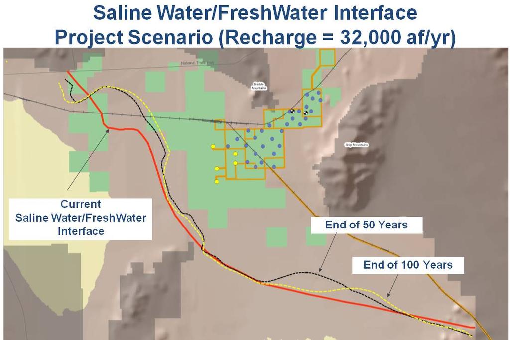
11 Potential Project Impacts Analyzed Impacts from Regional Drawdowns Migration of Saline/Freshwater Interface Land Subsidence Springs

12 10 ft Drawdown 30 ~ 80 ft Drawdowns 10 ft


13 Wellfield

14 Subsidence ft Subsidence ft Wellfield Wellfield

15 Location of Springs
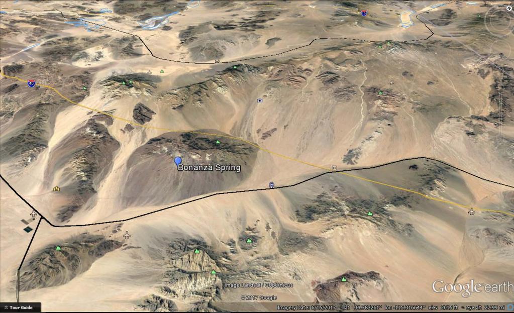
16 Setting

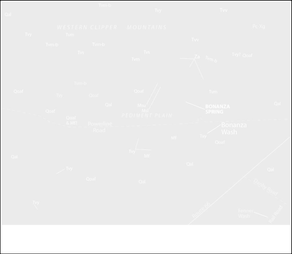
17 Clipper Mountains Geology

18 Catchment Area of Spring

19 Local Geology

20 Cross section B-B
21 Conceptual Model of Spring Groundwater recharge in upper elevations is the source of groundwater Groundwater flow through intrusives is controlled by transmissivity of these rocks and is impeded by faulting Groundwater flow downgradient occurs in fractured crystalline rocks, which discharges above the groundwater level in the alluvial aquifer Changes in groundwater levels in the alluvium will not effect groundwater levels at the spring Changes in long-term recharge control groundwater levels at the spring
22 Summary of Impacts Assessments Substantial volume of high quality groundwater in storage upgradient of proposed wellfield Pumping above natural recharge required to capture natural recharge AND groundwater already in transit to Dry Lakes Pumping an average of 50,000 AFY will not have significant impacts on the environment: groundwater levels, water quality, subsidence, springs
23 Water Quality Meets all Drinking Water Standards, Hexavalent chromium Cr(VI) average 14 μg/l vs. Cadiz is partnering with ATEC to remove Cr(VI). Recent pilot testing on Cadiz groundwater shows it is a cost-effective RCF technology approved by State DDW. Total Dissolved Solids (TDS) averages around ~330 mg/l
24 Groundwater Management, Monitoring, and Mitigation Plan (GMMMP) Avoid Undesirable Results Annual reports Five-year Groundwater Model Update and Comprehensive Re-Assessment of Groundwater Conditions Decision tree for response actions Extensive Mitigation Measures, and project design features, including potential to modify project operations Independent Technical Review Panel
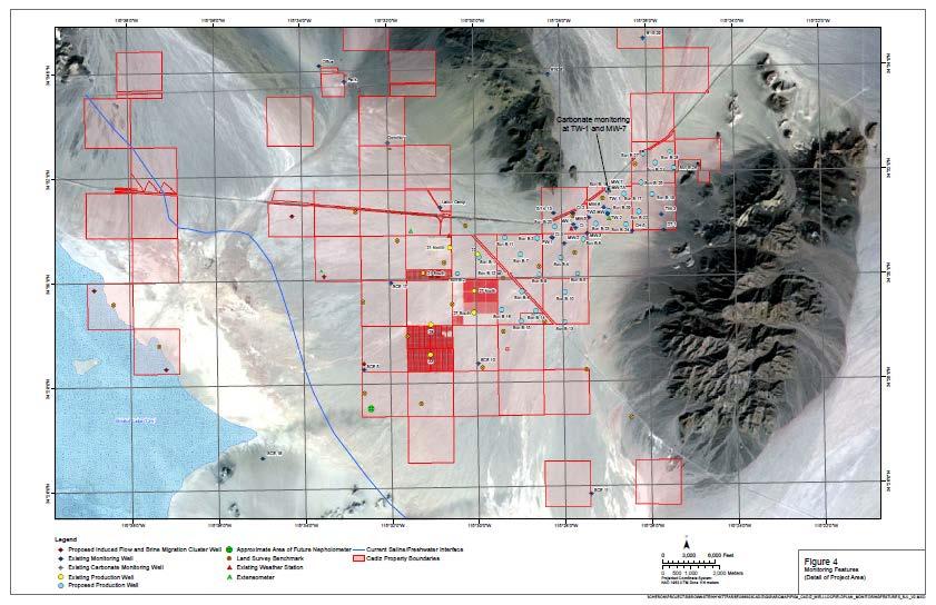
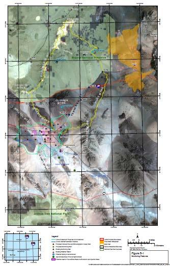
25 Monitoring Features
26 Groundwater Management, Monitoring, and Mitigation Plan 3 Springs 14 Existing Monitoring Wells 2 New Monitoring Wells 2 Existing Cluster Wells 9 New Cluster Wells 34 (5 existing and 29 New Extraction wells) 23 Land Survey Benchmarks InSAR surveys 3 New Extensometers 5 Flowmeter Surveys 4 Weather Stations 4 Nephelometers (air quality) Vegetation Monitoring

27 Phases 1 & 2 Connect SoCal s Major Water Transportation Routes
28 Questions?