Record of Site Condition Under Part XV.1 of the Environment Protection Act N4K 5W8
|
|
|
- Christopher Campbell
- 5 years ago
- Views:
Transcription
1 Ontario Ministry of the Environment and Climate Change - Record of Site Condition # Record of Site Condition Under Part XV.1 of the Environment Protection Act Summary Record of Site Condition Number Date Filed to Environmental Site Registry 2016/03/30 Certification Date 2015/06/22 Current Property Use Commercial Intended Property Use Residential Certificate of Property Use Number No CPU Applicable Site Condition Standards** Full Depth Generic Site Conditions Standard, with Potable Ground Water, Coarse Textured Soil, for Residential property use Property Municipal Address 850 ALPHA STREET, OWEN SOUND, ON, N4K 5W8 Notice to Readers Concerning Due Diligence This record of site condition has been filed in the Environmental Site Registry to which the public has access and which contains a notice advising users of the Environmental Site Registry who have dealings with any property to consider conducting their own due diligence with respect to the environmental condition of the property, in addition to reviewing information in the Environmental Site Registry. Contents of this Record of Site Condition This record of site condition consists (RSC) of this document which is available to be printed directly from the Environmental Site Registry as well as all supporting documentation indicated in this RSC to have been submitted in electronic format to the Ministry of the Environment and Climate Change. Filed Record of Site Condition # on 2016/03/30 1 of 17
2 Part 1: Property Ownership, Property Information and Owner s Certifications Information about the owner who is submitting or authorizing the submission of the record of site condition Owner name Authorized person Mailing address TURBITT MARINE LIMITED JAMES TURBITT HIGHWAY 6 AND 10, CHATSWORTH Ontario, Canada Postal Code N0H 1G0 Phone (519) Fax address Turbitt@bellnet.ca Filed Record of Site Condition # on 2016/03/30 2 of 17
3 Record of site condition property location information Municipal address(es) Municipality Legal description Assessment roll number(s) Property identifier number(s) 850 ALPHA STREET, OWEN SOUND, ON N4K 5W8 Owen Sound See attached Lawyer s letter (LT) Record of site condition property geographical references Coordinate system UTM Datum NAD 83 Zone 17 Easting 503, Northing 4,935, Record of site condition property use information The following types of property uses are defined by the Regulation: Agricultural or other use, Commercial use, Community use, Industrial use, Institutional use, Parkland use, and Residential use. Current property use Intended property use Certificate of property use has been issued under section of the Environmental Protection Act Commercial Residential No Filed Record of Site Condition # on 2016/03/30 3 of 17
4 Please see the signed statements of property owner, or agent, or receiver at the end of this record of site condition The rest of this page has been left intentionally blank Filed Record of Site Condition # on 2016/03/30 4 of 17
5 Part 2: List of reports, summary of site conditions and qualified person s statements and certifications Qualified person's information Name Type of licence under Professional Engineers Act MATTHEW D NELSON Licence Licence number Quallified person's employer name Mailing address GM BLUEPLAN ENGINEERING LIMITED ND AVENUE EAST, OWEN SOUND Ontario, N4K 2J3 Canada Phone (519) Fax (519) address matthew.nelson@gmblueplan.ca Municipal information Local or single-tier municipality Upper-tier municipality Owen Sound Grey Ministry of the Environment and Climate Change District Office District office District office address Owen Sound District Office th Street East, Owen Sound ON N4K 6H6 Filed Record of Site Condition # on 2016/03/30 5 of 17
6 Phase one environmental site assessment report Document used as the phase one environmental site assessment report and updates in submitting the record of site condition for filing The date the last work on all of the records review, interviews and site reconnaissance components of the phase one environmental site assessment was done (refer to clause 28(1) (a) of O. Reg. 153/04) (yyyy/mm/dd) Type of report Phase one environmental site assessment Report title Pottawatomi Gardens, 850 Alpha Street, Owen Sound, ON, Phase One Environmental Assessment Date of report (yyyy/mm/dd) Author of report Matthew Nelson, P. Eng., P. Geo. Name of consulting company GM BLUEPLAN ENGINEERING LIMITED Reports and other documents related to the phase one environmental site assessment Reports and other documents relied upon in certifying the information set out in section 10 of Schedule A or otherwise used in conducting the phase one environmental site assessment Report title Date of report (yyyy/mm/dd) Author of report Name of consulting company N/A Filed Record of Site Condition # on 2016/03/30 6 of 17
7 Phase two environmental site assessment report Document used as the phase two environmental site assessment report and updates in submitting the record of site condition for filing The date the last work on all of the planning of the site investigation and conducting the site investigation components of the phase two environmental site assessment was done (refer to clause 33.5(1)(a) of O. Reg. 153/04) (yyyy/mm/dd) Type of report Phase two environmental site assessment Report title Pottawatomi Gardens, 850 Alpha Street, Owen Sound, ON, Phase Two Environmental Assessment Date of report (yyyy/mm/dd) Author of report Matthew Nelson, P. Eng., P. Geo. Name of consulting company GM BLUEPLAN ENGINEERING LIMITED Reports and other documents related to the phase two environmental site assessment Reports and other documents relied upon in making any certifications in the record of site condition for the purposes of Part IV of Schedule A or otherwise used in conducting the phase two environmental site assessment Report title Date of report (yyyy/mm/dd) Author of report Name of consulting company N/A Filed Record of Site Condition # on 2016/03/30 7 of 17
8 Environmental condition Section 41 applies? Section 43.1 applies? No No Site condition information Certification date (yyyy/mm/dd) 2015/06/22 Total area of record of site condition property (in hectares) Number of any previously filed record of site condition that applies to any part of the record of site condition property Number of any previously filed transition notice that applies to any part of the record of site condition property Soil texture Assessment/restoration approach Site investigation includes the investigation, sampling and analysis of ground water? Is there soil present that is sufficient to investigate, sample and analyze soil on, in or under the property in accordance with s. 6, Schedule E of O.Reg. 153/04? Site investigation includes the investigation, sampling and analysis of soil on, in or under the property which is used in the record of site condition? Name of the laboratory used to analyze any samples collected of soil, ground water or sediment Ground water condition (potable, non-potable) Coarse Full depth generic Yes Yes Yes MAXXAM ANALYITCS Potable Applicable site condition standard TABLE 2 Filed Record of Site Condition # on 2016/03/30 8 of 17
9 Table 1 Maximum contaminant concentrations compared to applicable site condition standards Measured concentration for contaminants in soil Contaminant name Maximum concentration Applicable site condition 1 Petroleum Hydrocarbons F1**** < µg/g 2 Petroleum Hydrocarbons F2 < µg/g 3 Petroleum Hydrocarbons F3 < µg/g 4 Petroleum Hydrocarbons F4 < µg/g 5 Boron (Hot Water Soluble)* µg/g 6 Chromium VI < µg/g 7 Cyanide (CN-) < µg/g Unit of measure 8 Electrical Conductivity ms/cm 9 Mercury < µg/g 10 Sodium Adsorption Ratio Antimony < µg/g 12 Arsenic µg/g 13 Selenium < µg/g 14 Benzene < µg/g 15 Ethylbenzene < µg/g 16 Toluene < µg/g 17 Xylene Mixture < µg/g 18 Barium µg/g 19 Beryllium µg/g 20 Boron (total) µg/g 21 Cadmium µg/g 22 Chromium Total µg/g 23 Cobalt µg/g 24 Copper µg/g 25 Lead µg/g 26 Molybdenum < µg/g 27 Nickel µg/g 28 Silver < µg/g 29 Thallium µg/g 30 Uranium µg/g 31 Vanadium µg/g 32 Zinc µg/g Filed Record of Site Condition # on 2016/03/30 9 of 17
10 Table 1 Maximum contaminant concentrations compared to applicable site condition standards (Continued) Ground water Contaminant name Maximum concentration Applicable site condition 1 Benzene < µg/l 2 Ethylbenzene < µg/l 3 Toluene < µg/l 4 Xylene Mixture < µg/l 5 Petroleum Hydrocarbons F1**** < µg/l 6 Petroleum Hydrocarbons F2 < µg/l 7 Petroleum Hydrocarbons F3 < µg/l 8 Petroleum Hydrocarbons F4 < µg/l Unit of measure Filed Record of Site Condition # on 2016/03/30 10 of 17
11 Remedial action and mitigation Remediated soils Estimated quantities of the soil, if any, originating at and remaining on the record of site condition property that have been remediated, at a location either on or off the property, to reduce the concentration of contaminants in the soil. Indicate the remediation process or processes used and the estimated amount of soil remediated by each identified process. Soil remediation process Estimated quantity of soil (in groundvolume in cubic metres) Description of remediation Description of any action taken to reduce the concentration of contaminants (including soil removals) on, in or under the record of site condition property. Soil or sediment removed and not returned Estimated quantities of soil or sediment, if any, removed from and not returned to the record of site condition property. Estimated quantity of soil (in ground-volume in cubic metres) Estimated quantity of sediment (in ground-volume in cubic metres) Soil brought to the property Estimated quantity of the soil, if any, being brought from another property to and deposited at the record of site condition property, not including any soil that may have originated at but been remediated off the record of site condition property and that is identified in section 28 of Schedule A. Estimated quantity of soil brought to the property (in ground-volume in cubic metres) Filed Record of Site Condition # on 2016/03/30 11 of 17
12 Ground water control or treatment measures Ground water control or treatment measures that were required for the record of site condition property prior to the certification date for the purpose of submitting the record of site condition for filing. Ground water control or treatment measures that are required for the record of site condition property after the certification date. Estimated volume of ground water, if any, removed from and not returned to the record of site condition property. Estimated volume of ground water (in litres) Filed Record of Site Condition # on 2016/03/30 12 of 17
13 Other activities including risk management measures Constructed works that prior to the certification date for the purpose of submitting the record of site condition for filing, were required to control or otherwise mitigate the release or movement of known existing contaminants at the record of site condition property. Constructed works that after the certification date, are required to control or otherwise mitigate the release or movement of known existing contaminants at the record of site condition property. Monitoring or Maintenance Soil Management Measures Soil monitoring requirements or any requirements for care, maintenance or replacement or any monitoring or control works for known existing contaminants, if any, on the record of site condition property, after the certification date. Ground water management measures Ground water monitoring requirements or requirements for care, maintenance or replacement of any monitoring or control works or known existing contaminants, if any, on the record of site condition property, after the certification date. Remediated or removed soil, sediment or ground water from near property boundary Has any soil, sediment or ground water at the record of site condition property that is or was located within 3 metres of the record of site condition property boundary been remediated or removed for the purpose of remediation? No Filed Record of Site Condition # on 2016/03/30 13 of 17
14 C Qualified person s statements and certifications As the qualified person, I certify that: A phase one environmental site assessment of the record of site condition property, which includes the evaluation of the information gathered from a records review, site reconnaissance, interviews, a report and any updates required, has been conducted in accordance with the regulation by or under the supervision of a qualified person as required by the regulation. A phase two environmental site assessment of the record of site condition property, which includes the evaluation of the information gathered from planning and conducting a site investigation, a report, and any updates required, has been conducted in accordance with the regulation by or under the supervision of a qualified person as required by the regulation. The information represents the site conditions at the sampling points at the time of sampling only and the conditions between and beyond the sampling points may vary. As of 2015/06/22, in my opinion, based on the phase one environmental site assessment and the phase two environmental site assessment, and any confirmatory sampling, there is no evidence of any contaminants in the soil, ground water or sediment on, in or under the record of site condition property that would interfere with the type of property use to which the record of site condition property will be put, as specified in the record of site condition. Ground water sampling has been conducted in accordance with the regulation by or under the supervision of a qualified person as required by the regulation. As of 2015/06/22, in my opinion, based on the phase one and phase two environmental site assessments and any confirmatory sampling, the record of site condition property meets the applicable full depth generic site condition standards prescribed by section 36 of the regulation for all contaminants prescribed by the regulation in relation to the type of property use for which this record of site condition is filed, except for those contaminants (if any) specified in this record of site condition at Table 2, Maximum contaminant concentrations compared to standards specified in a risk assessment. As of 2015/06/22, the maximum known concentration of each contaminant in soil, sediment and ground water at the record of site condition property for which sampling and analysis has been performed is specified in this record of site condition at Table 1, maximum contaminant concentrations compared to applicable full depth generic site condition standards. I am a qualified person and have the qualifications required by section 5 of the regulation. I have in place an insurance policy that satisfies the requirements of section 7 of the regulation. I acknowledge that the record of site condition will be submitted for filing in the Environmental Site Registry, that records of site condition that are filed in the Registry are available for examination by the public and that the Registry contains a notice advising users of the Registry who have dealings with any property to consider conducting their own due diligence with respect to the environmental condition of the property, in addition to reviewing information in the Registry. The opinions expressed in this record of site condition are engineering or scientific opinions made in accordance with generally accepted principles and practices as recognized by members of the environmental engineering or science profession or discipline practising at the same time and in the same or similar location. I do not hold and have not held and my employer GM BLUEPLAN ENGINEERING LIMITED does not hold and has not held a direct or indirect interest in the record of site condition property or any property which includes the record of site condition property and was the subject of a phase one or environmental site assessment or risk assessment upon which this record of site condition is based. To the best of my knowledge, the certifications and statements in this part of the record of site condition are true as of 2015/06/22. By signing this record of site condition, I make no express or implied warranties or guarantees. By checking the boxes above, and entering my membership/licence number in this submission, I, MATTHEW D NELSON, a qualified person as defined in section 5 of O. Reg. 153/04 am, on 2016/03/18: a) signing this record of site condition submission as a qualified person; and b) making all certifications required as a qualified person for this record of site condition. Filed Record of Site Condition # on 2016/03/30 14 of 17
15 b) making all certifications required as a qualified person for this record of site condition. I agree Filed Record of Site Condition # on 2016/03/30 15 of 17
16 Additional documentation provided by property owner or agent The following documents have been submitted to the Ministry of the Environment and Climate Change as part of the record of site condition Certificate of status or equivalent for the owner Lawyer's letter consisting of a legal description of the property Copy of any deed(s), transfer(s) or other document(s) by which the record of site condition property was acquired A Current plan of survey Area(s) of potential environmental concern Table of current and past uses of the phase one property Phase 2 conceptual site model Owner or agent certification statements Filed Record of Site Condition # on 2016/03/30 16 of 17

17 Filed Record of Site Condition # on 2016/03/30 17 of 17
18 Request ID: Province of Ontario Date Report Produced: 2016/03/15 Demande n : Province de l'ontario Document produit le : Transaction ID: Ministry of Government Services Time Report Produced: 10:20:24 Transaction n : Ministère des Services gouvernementaux Imprimé à : Category ID: CT Catégorie : CERTIFICATE OF STATUS ATTESTATION DU STATUT JURIDIQUE This is to certify that according to the records of the Ministry of Government Services D'après les dossiers du Ministère des Services gouvernementaux, nous attestons que la société T U R B I T T M A R I N E L I M I T E D Ontario Corporation Number Numéro matricule de la société (Ontario) is a corporation incorporated, amalgamated or continued under the laws of the Province of Ontario. The corporation came into existence on est une société constituée, prorogée ou née d'une fusion aux termes des lois de la Province de l'ontario. La société a été fondée le J U L Y 0 1 J U I L L E T, and has not been dissolved. et n'est pas dissoute. Dated Fait le M A R C H 1 5 M A R S, Director Directeur The issuance of this certifcate in electronic form is authorized by the Ministry of Government Services. La délivrance du présent certificat sous forme électronique est autorisée par le Ministère des Services gouvernementaux.
19

20

21
22
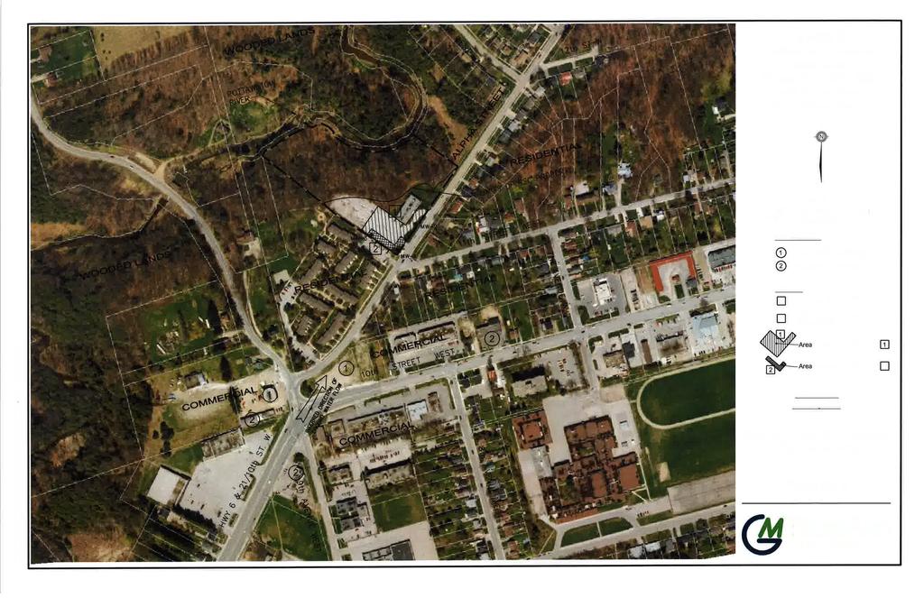
23 "Table of areas of potential environmental concern" (Refer to clause 16(2)(a), Schedule D, O. Reg. 153/04) Area of potential environmental concern 1 APEC # 1: The unknown quality of fill material associated with the onsite parking areas Location of area of potential environmental concern on phase one property Within the parking lot of the subject property Potentially contaminating activity 2 (PCA # 30) Importation of Fill Material of Unknown Quality Location of PCA (on-site or off-site) On-Site Contaminants of potential concern 3 Metals, As, Sb, Se, Na, Cr (VI), B-HWS Media potentially Impacted (Ground water, soil and/or sediment) Soil (PCA # 28; 52) APEC #2: The potential for impact to the subject property related to historic petroleum hydrocarbon storage and handling at off-site properties. The south and southwesterly portions of the property. PCA #28: Gasoline and Associated Products Storage in Fixed Tanks; PCA #52: Storage, maintenance, fuelling and repair of equipment, vehicles, and material used to maintain transportation systems Off-Site BTEX, and PHCs Groundwater and/or Soil Notes: 1 - Areas of potential environmental concern means the area on, in or under a phase one property where one or more contaminants are potentially present, as determined through the phase one environmental site assessment, including through, (a) identification of past or present uses on, in or under the phase one property, and (b) identification of potentially contaminating activity. 2 - Potentially contaminating activity means a use or activity set out in Column A of Table 2 of Schedule D that is occurring or has occurred in a phase one study area 3 - When completing this column, identify all contaminants of potential concern using the Method Groups as identified in the "Protocol for in the Assessment of Properties under Part XV.1 of the Environmental Protection Act, March 9, 2004, amended as of July 1, 2011, as specified below:

24
25 PHASE TWO ENVIRONMENTAL SITE ASSESSMENT 850 ALPHA STREET POTTAWATOMI GARDENS RESIDENCE OUR FILE: Phase Two Conceptual Site Model The direction of groundwater flow at the Phase One Property and study area is inferred to be in a north to north-easterly direction due to the presence of the Pottawatomi River to the north of the Phase One Property and the topographic relief of the area, which falls from south to north, ultimately towards Georgian Bay. As previously reported, the first developed use of the Phase One Property was for commercial use in 1974 as a multi-tenant medical office space. The immediate adjacent properties to the west, east and south are currently residential properties and appear to have been residential properties since their first developed use. The adjacent property to the north and lands surrounding the Pottawatomi River are currently zoned as Environmental Hazard land due to the pronounced slope that extends downward to the river and does not appear to have ever been developed. The Phase One ESA conceptual site model identified two Areas of Potential Environmental Concern (as presented on Figure 2). APEC 1 associated with the on-site property use is considered to be associated with the potential use of fill of unknown quality. This APEC is considered to be located in areas outside of the existing building footprint (i.e., parking lots). The potential contaminants of concern (PCOCs) associated with this APEC is considered to be metals and inorganics. The potential media affected is considered to be soil. Where soil impacts exist, groundwater may become a receptor of impacts. The second APEC (APEC 2) is considered to exist due to off-site sources. An area consisting primarily of roadside commercial development located approximately 120m to 200m south of the Site on 10 th Street West historically included five retail fuel stations and/or vehicle servicing garages. The businesses located along 10 th Street are considered hydraulically upgradient of the Phase One Property. These properties are considered to be an area that is generally upgradient of the Phase One Property and that have the potential for groundwater migration toward the Phase One Property. Therefore, the APEC is considered to be the south and southwestern portion of the property. The potential contaminants of concern (PCOCs) associated with APEC 2 include benzene, toluene, ethylbenzene, and xylenes (BTEX), and petroleum hydrocarbons (PHCs) in the F1 to F4 fractions. The media potentially impacted by the migration onto the Phase One Property is soil and/or groundwater. The identified APECs were investigated through the advancement of boreholes and installation of monitoring wells in selected locations throughout the Phase Two Property. Based on the location of the identified APECs and the distances observed to the surrounding utilities, the risk of the transport and migration of PCOCs along, across, or beyond the Phase Two Property boundaries is considered to be low.
26 The soil profile at the Phase Two Property was found to consist primarily of sandy silt to depths of greater than 3 m bgs., which is further underlain by a relatively thick layer of stiff to hard grey/brown clay, which extends to the depth of the bedrock surface encountered at an approximate depth of 16 metres (53 ft.) below ground surface. Based on the geologic information for the area, the overburden is expected to be in the range of 15 to 30m thick. The clayey silt till appears to have a complex occurrence of discrete sand lenses ranging in thickness from 0.05 to 1.5 m. The recorded depth to the shallow water table is generally in the range of 3m bgs. The existing office building is to remain in its current condition and configuration with no known structural additions proposed. The Phase Two Property is not in an environmentally sensitive area, it is not a shallow soil property, and is not within thirty metres of a water body. Therefore, sections 41 and 43.1 of the Regulation are not applicable to the Phase Two Property. The subject property and immediate surrounding properties are serviced by the municipal water service provided by the City of Owen Sound, which obtains its water from Georgian Bay. However, it is somewhat unclear if the properties located directly on the west side of 9 th Avenue West are serviced by onsite drilled water wells. Therefore, although the subject property is considered to be in a Table 3, non-potable groundwater setting, the laboratory analysis on submitted soil and groundwater samples were compared to the Table 2 Criteria of the Soil, Ground Water, and Sediment Standards for Use Under Part XV.1 of the Environmental Protection Act (April 15, 2011), under O. Reg. 153/04 (as amended), with coarse textured soils with residential/parkland/institutional property use. Additionally, based on the use of the property as commercial office space since the time of its initial development, the Phase Two Property is not considered an enhanced investigation property. Based on the site investigation and analytical findings, the analytical results for soil and groundwater samples meet the Table 2 full-depth generic Standard for a residential/parkland/institutional setting with coarse textured soils. As such, no further investigation is recommended at this time. Based on the field investigations, sampling program, and on the nature and extent of soils identified at the Phase Two property, there are no areas where soil has been brought from another property and placed on, in, or under the Phase Two property as part of the Phased ESA process. It is noted that at the time of the field investigations, the finished surface of the parking lot had been removed and the underlying soils were exposed allowing visual investigation. No suspect soils and no evidence of impact associated with APEC 1 was identified during the investigation. The Conceptual Site Model is based on available information collected through the standard Phased ESA process. The utilities present at the Phase Two Property are not considered to influence the migration of PCOCs. There are no known absences of information or uncertainty regarding the available records that are considered to have an affect on the validity of the model.

27

28

29

30
31


32

33


34