Protect, Accommodate, or Retreat? Integrating Adaptation Strategies and Ecosystem Services into the Cape Cod Coastal Planner
|
|
|
- Claud John Norman
- 5 years ago
- Views:
Transcription

1 Protect, Accommodate, or Retreat? Integrating Adaptation Strategies and Ecosystem Services into the Cape Cod Coastal Planner Jennifer Clinton Cape Cod Commission April Wobst Association to Preserve Cape Cod
2 Project Overview Jennifer Clinton, Special Projects Coordinator, Cape Cod Commission


3 NOAA Coastal Resiliency Grant Program Competitive grants for 3-year projects that advance coastal resilience through: Land/ocean use planning Disaster preparedness projects Environmental restoration Hazard mitigation planning Other regional/state/ community planning efforts


4 Project Overview Three-year, $780,000 grant awarded to the Cape Cod Commission and partners Investigate environmental and socio-economic effects of local and regional coastal resiliency strategies Town of Barnstable pilot program GRANT PARTNERS SUPPORTING AGENCIES


5 Committee Roles A D V I S O R Y B O A R D S C I E N C E C O M M I T T E E ADAPTATION STRATEGIES COMMITTEE R E G U L A T O R Y + L E G A L C O M M I T T E E Provide advice on the overall approach and key decisions Review draft work product Provide access to data on natural hazards Interpret climate, weather and coastal geology data Review and comment on strategies database Advise team on how to apply strategies across the Cape Ensure the implementation of appropriate strategies across the region
6 Project Phases ONE Data Collection and Adaptation Strategies Database TWO Public Engagement and Socio-Economic Analysis THREE Communication and Decision-Support Tool


7 Resiliency Decision Support Tool Framework Adaptation Strategies Database Feeds the options for strategy selection Users select a strategy to address coastal hazards. The database also informs tool outputs, with factors such as benefits provided, disadvantages, etc. GIS Map Layers Serve as planning layers to model current and future conditions TOOL Socio-Economic Analysis Informs the impacts of the selected strategies Feeds tool outputs. Communicate benefits of ecosystem services, integrate into decisionmaking process

8 Stakeholder Engagement T O O L B E T A T E S T E R G R O U P Provided feedback as decision support tool was developed Helped shape functionality, fine tune outputs, and create wish list for future versions S U B R E G I O N A L S T A K E H O L D E R S Engaged participants across the region based on their connection to the waters that surround the Cape. Presented information and solicited feedback that informed the tool s development

9 Stakeholder Engagement Outer Cape Buzzards Bay Cape Cod Bay Nantucket Sound S U B R E G I O N A L S T A K E H O L D E R S Engaged participants across the region based on their connection to the waters that surround the Cape. Presented information and solicited feedback that informed the tool s development

10 Understanding Vulnerability and Coastal Systems

11 Source: USGS

12 Source: APCC
13
14
15 Adaptation Strategies Matrix April Wobst, Restoration Ecologist, Association to Preserve Cape Cod

16 WHAT STRATEGIES INCREASE COASTAL RESILIENCY ON CAPE COD?
17 Adaptation Strategy: an action that can be taken to protect an area from coastal hazards


18 Collecting Coastal Resiliency Data Spectrum of Adaptation Strategies DO NOTHING? BEACH NOURISHMENT? OFFSHORE REEFS? COASTAL ARMORING?
19 Collecting Coastal Resiliency Data DATA ON RESILIENCE STRATEGIES CREATE DATABASE LINK TO GIS, DECISION SUPPORT TOOL Data collection on site requirements, costs, life span, advantages and disadvantages Information will live at the Commission; shareable & exportable for use by policy makers, stakeholders Geo-referenced data and tool allow users to test resiliency scenarios risk-free


20 Adaptation Strategies Database Development Researched and gathered data on adaptation strategies for region-wide database Strategy types include: Policy Strategies Hard (or Engineered) Strategies Soft (or Green) Strategies Based on literature review with input from local and regional partners and experts

21 Adaptation Strategies Committee M I S S I O N To review and comment on the structure and content of the adaptation strategies database, suggest strategies to include, and provide advice on considerations for applying strategies across the region M E M B E R S Paul Kirshen, UMass Boston Lisa Auermuller, Jacques Cousteau NERR Greg Berman, WHOI Seagrant/Cape Cod Cooperative Extension John Ramsey, Applied Coastal Julia Knisel, MA Coastal Zone Management Seth Wilkinson, Wilkinson Ecological Jim O Connell, Coastal Advisory Services
22 Adaptation Strategies Database Database (24 data fields): Description Type of Strategy Benefits and limitations Scale Costs and Maintenance Siting and Constraints Case Studies

23 Adaptation Strategies Database Categorized by type of strategy: Protect an area from coastal hazards, Accommodate the coastal hazard within the area through some modification of infrastructure or the natural system, or Retreat from an area by removing buildings or structures.
24 ADAPTATION STRATEGIES DATABASE P R O T E C T A C C O M M O D AT E R E T R E AT
25 Adaptation Strategies Database 45 STRATEGIES 15 Nature Based Solutions (Non-CES) 19 Structural Solutions (CES) 11 Policy approaches

26 DESCRIPTION: Gradually moving development and infrastructure away from the coastline and areas of projected loss due to flooding and sea level rise.


27 ADVANTAGES: Spares existing development from the effects of erosion and flooding. Protects future development from flooding. Allows for the maintenance or restoration of intertidal habitat. DISADVANTAGES: Cost of moving development. Acquisition of land for new development. Loss of coastal property values.


28 DESCRIPTION: Cylindrical rolls, inches in diameter & feet long, made of coir (coconut) fiber held together by a fiber mesh, covered with sand, and are planted with salt-tolerant vegetation with extensive root systems. These reinforced banks act as physical barriers to waves, tides, and currents. They typically disintegrate over 5-7 years to allow plants time to grow their root systems to keep sand and soil in place.


29 DESCRIPTION: A living shoreline has a footprint that is made up mostly of native material. It incorporates vegetation or other living, natural soft elements alone or in combination with some other type of harder shoreline structure (e.g. oyster reefs or rock sills) for added stability. A combined approach integrates living components, such as plantings, with strategically placed structural elements, such as sills, revetments, and breakwaters.
30 Socio-Economic Analysis Jennifer Clinton, Special Projects Coordinator, Cape Cod Commission

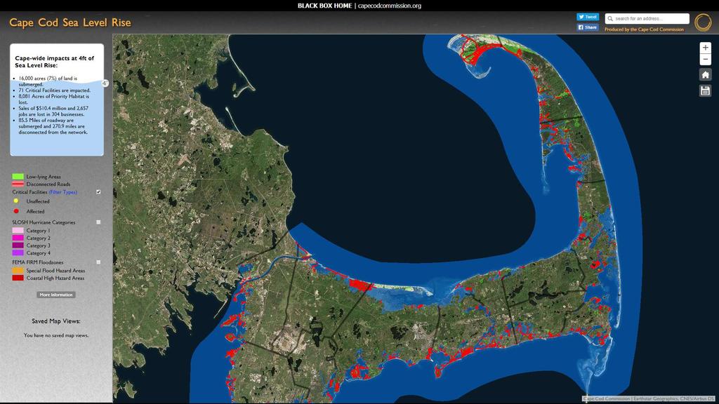
31 Goals for Socio-Economic Analysis 1. Understanding how Cape Cod values coastal ecosystems 2. Understanding how these values might be impacted by climate change, erosion, sea level rise, and adaptation to these forces 3. Integrating this research into a GISbased decision support tool
32 Ecosystem Services: direct and indirect contributions from ecosystems to human well-being The Economics of Ecosystems and Biodiversity (TEEB)
33 Cape Cod Ecosystem Services E C O S Y S T E M S Coastal beaches Coastal dunes Land under the ocean Barrier beaches Coastal banks Rocky intertidal shores Salt marshes S E R V I C E S Storm damage protection Flood control Protection of wildlife habitat Protection of marine fisheries Sediment supply Groundwater pollution prevention
34 Understanding Tradeoffs How do we value our environment? Dollar values don t matter as much as relative values Goal of GIS tool: Make tradeoffs explicit between adaptation strategies and changes in ecosystem values
35 Understanding Tradeoffs Why do we value our environment? Policy choices often come down to cost Without understanding the cost or value of the environment, it can t be properly factored into decisions Short-term benefits outweigh long-term ones
36 Decision Support Tool
37 Intended Users Designed as an educational tool to help town staff, county staff and consultants facilitate conversations and support community decision making around coastal resiliency issues. Conversation starter and communication tool.

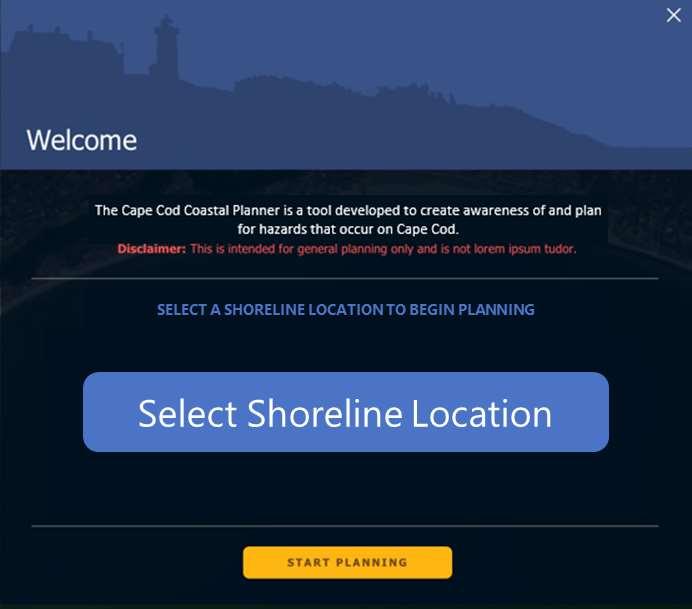
38 Cape Cod Coastal Planner

39 Cape Cod Coastal Planner Vulnerability Ribbon LOW MEDIUM HIGH

40 Cape Cod Coastal Planner
41 Behind the Scenes:

42 Behind the Scenes:

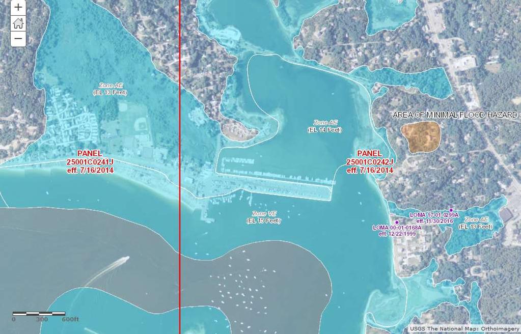
43 GENERAL PLANNING LAYERS Structures Sewer Infrastructure Public Roads Private Roads Rare Habitat Areas of Critical Environmental Concern Districts of Critical Planning Concern Historic Properties SEA LEVEL RISE 1FT 2FT -3FT 4FT 5FT 6FT Disconnected Roads Critical Facilities COASTAL EROSION Sediment Transport Historic Shoreline Positions STORM SURGE FEMA FIRM Flood Zones SLOSH Hurricane Categories 1-4 ADD YOUR LAYERS
44 Cape Cod Coastal Planner
45 Cape Cod Coastal Planner

46 Cape Cod Coastal Planner

47 Cape Cod Coastal Planner

48 Cape Cod Coastal Planner
49 Output Panel Cost, Lifespan, Scale directly from Adaptation Strategies Matrix Click instantly between no action and any other selected strategy
50 Output Panel Relative to No Action ( No change ) Protected vs. Lost KEY CONTEXT Scenario addressed, location, duration, scenario size (length of user-selected segments) INFRASTRUCTURE VALUES Public Building Value, Private Land and Building Value

51 Output Panel Ecosystem Services Salt Marsh Change Beach Area Change Rare Species Habitat Critical Facilities Relocated/Protected or Lost

52 Ecosystem Services A COMPROMISE Inclusion of ecosystem services critical to tool s purpose and outputs Direct comparison to infrastructure values was problematic and misrepresented with available data Currently include impacted acres for scale, and use information hovers to educate

53 Next Steps

54 Barnstable Pilot Project Town of Barnstable Pilot Project Advance the Towns of Barnstable s resiliency planning efforts, improve property owner understanding of the threats of climate change and SLR, identify and highlight the costs of doing nothing, as well as the costs and benefits of different adaptation scenarios. Stakeholder Workshops to define the potential damage and loss of properties within a hazard area boundary, communicate those potential losses, and identify potential solutions. Test Decision-Support Tool in its ability to effectively communicate resiliency issues

55 P R O J E C T W E B S I T E capecodcommission.org/resiliency THE RESILIENT CAPE COD PROJECT