A. Proposed TOR. April Vedanta Limited- Cairn Oil & Gas
|
|
|
- Abner Barrett
- 5 years ago
- Views:
Transcription
1 Proposed Terms of Reference for EIA Study of the Proposed Onshore Oil and Gas Exploration and Appraisal Project in AA-ONHP-2017/14 Hydro Carbon Block inkarimganj, Hailakandi, Cachar districts of Assam and Kolasib district of Mizoram Standard ToR for Conducting EIA Study for project/ activity 1 (b) [Onshore Oil and Gas Exploration, Development and Production] and Information to be included in EIA/EMP Report will be followed, which is provided in the following section. **Considering the temporary and short-term nature of the proposed project activities the Expert Appraisal Committee (EAC) is requested for Exemption of the Public Hearing. A. Proposed TOR 1. Executive summary of a project. 2. Project description, project objectives and project benefits. 3. Cost of project and period of completion. 4. Site details within 1 km of the each proposed well, any habitation, any other installation/activity, flora and fauna, approachability to site, other activities including agriculture/land, satellite imagery for 10 km area. All the geological details shall be mentioned in the Topo sheet of 1:40000 scale, superimposing the well locations and other structures of the projects. Topography of the project site. 5. Details of sensitive areas such as National Park, Wildlife sanctuary and any other eco-sensitive area alongwith map indicating distance. 6. Approval for the forest land from the State/Central Govt. under Forest (Conservation) Act, 1980, if applicable. 7. Recommendation of SCZMA/CRZ clearance as per CRZ Notification dated 6th January 2011 (Notapplicable). 8. Distance from nearby critically/severely polluted area as per Notification, if applicable. Status of moratorium imposed on the area. 9. Does proposal involve rehabilitation and resettlement? If yes, details thereof. 10. Environmental considerations in the selection of the drilling locations for which environmental clearance is being sought. Present any analysis suggested for minimizing the foot print giving details of drilling and development options considered. 11. Baseline data collection for air, water and soil for one season leaving the monsoon season in an area of 10 km radius with centre of Oil Field as its centre covering the area of all proposed drilling wells. 12. Climatology and Meteorology including wind speed, wind direction, temperature rainfall relative humidity etc. 13. Details of Ambient Air Quality monitoring at 18 locations for PM 2.5, PM 10, SO 2, NOx, CO, VOCs, Methane and non-methane HC. 14. Soil sample analysis (physical and chemical properties) at the areas located at 18 locations. 15. Ground and surface water quality in the vicinity of the proposed wells site. April Vedanta Limited- Cairn Oil & Gas
2 16. Measurement of Noise levels within 1 km radius of the proposed wells. 17. Vegetation and land use; flora/fauna in the block area with details of endangered species, if any. 18. Incremental GLC as a result of DG set operation, flaring etc. 19. Potential environmental impact envisaged during various stages of project activities such as site activation, development, operation/ maintenance and decommissioning. 20. Actual source of water and Permission for the drawl of water from the Competent Authority. Detailed water balance, wastewater generation and discharge. 21. Noise abatement measures and measures to minimize disturbance due to light and visual intrusions. 22. Details on wastewater generation, treatment and utilization /discharge for produced water/ formation water, cooling waters, other wastewaters, etc. during all project phases. 23. Details on solid waste management for drill cuttings, drilling mud and oil sludge, produced sand, radioactive materials, other hazardous materials, etc. including its disposal options during all project phases. 24. Disposal of spent oil and lube. 25. Storage of chemicals and diesel at site. Hazardous material usage, storage and accounting. 26. Commitment for the use of water-based mud (WBM) only.(#) Synthetic Base Mud (SBM) will be used in specific hole problems due to difficult geological formations & in deeper sections to drill. 27. Oil spill emergency plans for recovery/ reclamation. 28. H 2 S emissions control. 29. Produced oil/gas handling, processing and storage/transportation. 30. Details of control of air, water and noise pollution during production phase. 31. Measures to protect ground water and shallow aquifers from contamination. 32. Whether any burn pits being utilized for well test operations. 33. Risk assessment and disaster management plan for independent reviews of well-designed construction etc. for prevention of blow out. Blowout preventer installation. 34. Environmental management plan. 35. Total capital and recurring cost for environmental control measures. 36. Emergency preparedness plan. 37. Decommissioning and restoration plans. 38. Documentary proof of membership of common disposal facilities, if any. 39. Details of environmental and safety related documentation within the company including documentation and proposed occupational health and safety Surveillance Safety Programme for all personnel at site. This shall also include monitoring programme for the environmental. 40. A copy of Corporate Environment Policy of the company as per the Ministry s O.M. No. J / 41/2006-IA.II (I) dated 26 th April, 2011 available on the Ministry s website. 41. Any litigation pending against the project and or any direction/order passed by any court of law against the project. If so details thereof. April Vedanta Limited- Cairn Oil & Gas
3 Baseline Monitoring Plan for EIA Study of the Proposed Onshore Oil and Gas Exploration and Appraisal Project in AA-ONHP- 2017/14 Hydro Carbon Block ininkarimganj, Hailakandi, Cachar districts of Assam and Kolasib district of Mizoram Sl. No Monitoring Location 1. Micro Meteorological Station Proposed Geographical Co-ordinate Environmental Attribute of the Location 24 39'39.79"N 92 34'42.96"E Wind speed, Wind direction, temperature, Relative humidity, Rainfall, Solar radiation, Cloud cover Air Quality Monitoring Locations 1. AAQ '27.77"N 92 23'44.31"E PM10 and PM2.5, Nitrogen Dioxide(NO2), Sulphur Dioxide (SO2), Carbon Monoxide(CO), Ozone(O3), Benzene(C6H6), Benzo alpha pyrene (BaP), Lead(Pb), 2 AAQ '53.48"N 92 25'41.13"E 3 AAQ '38.55"N 92 23'47.14"E 4 AAQ '39.73"N 92 28'4.57"E 5 AAQ '4.52"N 92 20'54.28"E 6 AAQ '23.77"N 92 35'41.47"E 7 AAQ '24.63"N 92 43'12.76"E 8 AAQ '29.98"N 92 41'33.97"E 9 AAQ '52.92"N 92 36'20.73"E 10 AAQ '10.67"N 92 31'23.09"E 11 AAQ '10.36"N 92 30'56.42"E 12 AAQ '3.46"N 92 24'41.99"E 13 AAQ '38.15"N 92 22'29.34"E 14 AAQ '50.22"N 92 30'16.35"E 15 AAQ '30.53"N 92 36'17.31"E 16 AAQ '35.28"N 92 40'4.15"E 17 AAQ '15.54"N 92 44'7.68"E 18 AAQ '59.42"N 92 46'29.28"E Surface Water Quality Monitoring Stations 1 SWQ 1 Arsenic(As), Nickel(Ni), Ammonia(NH3), Hydrocarbons(HC)- both methane and nonmethane, Volatile Organic Compounds 24 42'8.51"N 92 27'13.30"E ph, temperature, turbidity, electrical conductivity, TDS, total 2 SWQ '32.19"N 92 24'27.29"E hardness, alkanity, chloride, 3 SWQ3 sulphate, nitrate, residual chlorine, 24 49'29.02"N 92 23'13.08"E Period of Monitoring Frequency Hourly for 13 Weeks in Summer 24 hourly for all parameters (except 8 hourly for Hydrocarbons, CO and O3), twice a week for 13 weeks in Summer Once during study period Remarks Monitored by installing an automated continuous meteorological monitoring station Ambient Air Quality (AAQ) monitored within the study area (within 10 km radius). Surface water samples will be collected from the study area (within 10 km radius). April Vedanta Limited- Cairn Oil & Gas
4 Sl. No Monitoring Location Proposed Geographical Co-ordinate of the Location Environmental Attribute 4 SW Q '14.42"N 92 36'44.55"E fluoride, sodium, potassium, salinity, total nitrogen, total phosphorus, DO, BOD, COD, phenol, heavy metals (As, Cd, Hg, Ni, Mn, Cr+6, Pb, Fe, Cu, Zn), total coliform and faecal coliform, Colour, Odour, taste, Aluminium (as Al), Anionic detergents, Barium, Calcium(as Ca), Chloramine(as Cl2), Magnesium(as Mg), Mineral Oil, Selenium, Cyanide, Molybdenum, 5 SWQ '9.22"N 92 32'41.77"E 6 SWQ '43.58"N 92 28'53.27"E 7 SWQ '42.30"N 92 46'13.55"E 8 SWQ '3.60"N 92 46'24.10"E 9 SWQ '27.21"N 92 37'10.12"E 10 SWQ '43.27"N 92 38'14.12"E 11 SWQ '56.71"N 92 31'30.66"E 12 SWQ '41.85"N 92 34'47.81"E 13 SWQ '30.43"N 92 47'18.31"E 14 SWQ '57.01"N 92 38'21.19"E 15 SWQ '45.83"N 92 37'2.75"E 16 SWQ '37.05"N 92 19'59.21"E 17 SWQ '49.92"N 92 19'42.95"E 18 SWQ '21.87"N 92 27'20.66"E Ground Water Quality Monitoring Station 1 GWQ '32.28"N 92 24'42.97"E 2 GWQ '44.14"N 92 29'47.71"E 3 GWQ '36.06"N 92 36'24.89"E 4 GWQ '15.45"N 92 43'41.81"E 5 GWQ '55.02"N 92 20'36.93"E 6 GWQ '28.27"N 92 33'35.63"E 7 GWQ '31.24"N 92 42'38.47"E 8 GWQ '20.29"N 92 44'5.02"E 9 GWQ '43.68"N 92 33'57.36"E 10 GWQ '23.43"N 92 20'29.99"E 11 GWQ '34.27"N 92 20'56.42"E 12 GWQ '5.73"N 92 37'17.09"E 13 GWQ '33.46"N 92 41'3.21"E 14 GWQ '13.91"N 92 25'5.23"E Pesticides, Polychlorinated biphenyls, PAH, Trihalomethanes, SAR and free Ammonia ph, temperature, turbidity, electrical conductivity, TDS, total hardness, alkanity, chloride, sulphate, nitrate, residual chlorine, fluoride, sodium, potassium, salinity, total nitrogen, total phosphorus, DO, phenol, heavy metals (As, Cd, Hg, Ni, Mn, Cr+6, Pb, Fe, Cu, Zn), total coliform and faecal coliform, Color, Odour, taste, Aluminium (as Al), Anionic detergents, Barium, Calcium (as Ca), Chloramine (as Cl2), Magnesium (as Mg), Mineral Oil, Selenium, Cyanide, Molybdenum, Pesticides (all pesticide parameters to be carried out as mentioned in IS Period of Monitoring Frequency Once during study period Remarks Ground water samples will be collected from the study area (within 10 km radius). April Vedanta Limited- Cairn Oil & Gas
5 Sl. No Monitoring Location Proposed Geographical Co-ordinate of the Location Environmental Attribute 15 GWQ '20.83"N 92 28'49.23"E 10500), Polychlorinated biphenyls, 16 GWQ '37.31"N 92 31'33.74"E PAH, Trihalomethanes, SAR and 17 GWQ 17 free Ammonia 24 47'42.38"N 92 43'6.41"E 18 GWQ '31.00"N 92 47'8.87"E Noise Quality Monitoring Locations 1 NQ '27.77"N 92 23'44.31"E Leq db(a) min, max, Avg (day and 2 NQ 2 night) 24 32'53.48"N 92 25'41.13"E 3 NQ '38.55"N 92 23'47.14"E 4 NQ '39.73"N 92 28'4.57"E 5 NQ '4.52"N 92 20'54.28"E 6 NQ '23.77"N 92 35'41.47"E 7 NQ '24.63"N 92 43'12.76"E Period of Monitoring Frequency Once during study period Remarks Noise levels will be monitored on hourly basis for 24 hours using continuous noise monitoring equipment along the project fencing and receptors in the vicinity. 8 NQ '29.98"N 92 41'33.97"E 9 NQ '52.92"N 92 36'20.73"E 10 NQ '10.67"N 92 31'23.09"E 11 NQ '10.36"N 92 30'56.42"E 12 NQ '3.46"N 92 24'41.99"E 13 NQ '38.15"N 92 22'29.34"E 14 NQ '50.22"N 92 30'16.35"E 15 NQ '30.53"N 92 36'17.31"E 16 NQ '35.28"N 92 40'4.15"E 17 NQ '15.54"N 92 44'7.68"E 18 NQ '59.42"N 92 46'29.28"E Soil Quality Monitoring Locations 1 SQ '5.62"N 92 26'49.64"E Particle size distribution, texture, % 2 SQ '10.45"N 92 33'46.71"E 3 SQ '5.31"N 92 43'56.84"E 4 SQ '9.20"N 92 38'5.37"E 5 SQ '46.44"N 92 28'48.38"E moisture, alkanity, acidity, specific gravity, bulk density, porosity, infiltration capacity, ph, electrical conductivity, nitrogen, phosphorus, potassium (NPK), calcium, Once during the study period Soil samples will be collected from the study area (within 10 km radius). April Vedanta Limited- Cairn Oil & Gas
6 Sl. No Monitoring Location Proposed Geographical Co-ordinate of the Location Environmental Attribute 6 SQ '45.80"N 92 24'20.06"E magnesium, chloride, sulphate, 7 SQ '8.67"N 92 20'50.83"E carbonate, boron, sodium, cation 8 SQ 8 exchange capacity, heavy metals 24 41'33.41"N 92 24'7.46"E (As, Cd, Hg, Ni, Mn, Cr+6, Pb, Fe, 9 SQ '17.37"N 92 28'9.61"E Cu, Zn), Sodium Absorption Ratio 10 SQ '13.31"N 92 35'21.20"E (SAR), Organic matter, Organic 11 SQ '56.88"N 92 38'29.16"E carbon, permeability, water holding 12 SQ '14.10"N 92 43'21.12"E capacity, Metals (Sb, Ba, Cr+3, Co, 13 SQ '28.08"N 92 22'52.11"E Mo), Cyanide, thiocyanate 14 SQ '9.91"N 92 25'46.66"E 15 SQ '43.14"N 92 33'12.07"E 16 SQ '2.99"N 92 35'5.75"E 17 SQ '5.37"N 92 35'44.93"E 18 SQ '54.90"N 92 44'53.30"E Traffic Study 1 T1 2 T2 3 T3 Traffic movement monitoring Period of Monitoring Ecological Study 1 Within Study area Ecological Survey Flora & Fauna Frequency Socio Economic Study 1 Within Study area Socio-economic study covering the block and surrounding areas # Surface water and Ground water samples shall be collected as per availability within the study area Once during the study period Once during the study period Remarks Traffic movement shall be monitored on hourly basis for 24 hours (to and from directions) during one of the week day and one of the holiday. Ecological survey to assess the biodiversity aspects. April Vedanta Limited- Cairn Oil & Gas
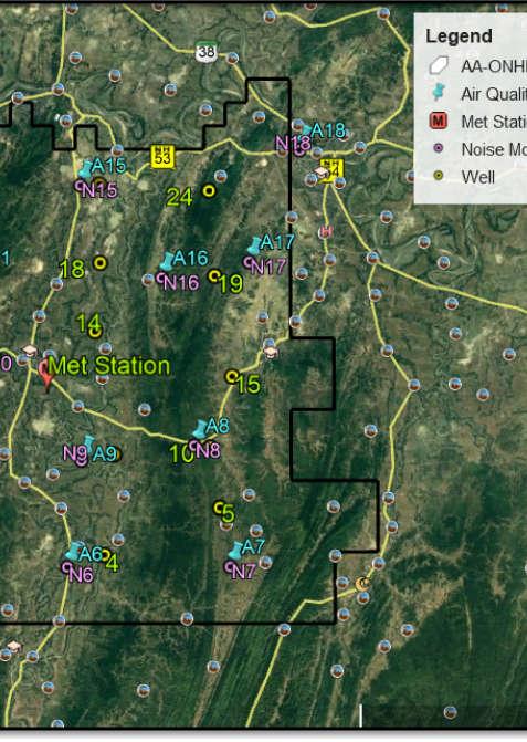
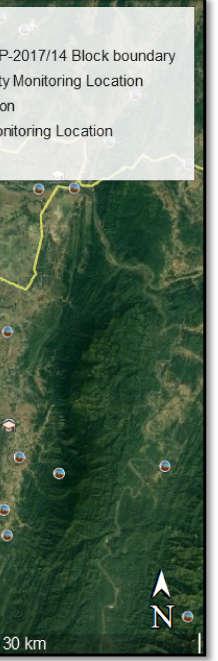
7 Maps Showing the Monitoring Location April Vedanta Limited- Cairn Oil & Gas
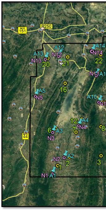
8 Figure 1Monitoring Location Map Air, Noise and Micro-Meteorology


9 Figure 2Monitoring Location Map Inland Surface Water, Ground Water and Soil