Drawing lines on Ag land for a Green Infrastructure Plan
|
|
|
- Grant Lamb
- 5 years ago
- Views:
Transcription

1 Drawing lines on Ag land for a Green Infrastructure Plan September 19, 2013 NACD Urban & Community Conservation Webinar George Boggs, Executive Director Whatcom Conservation District gboggs@whatcomcd.org x 115

2 About our County British Columbia Whatcom County Island County Skagit County


3 Basic Question: How to reconcile seemingly competing uses?


4 Look for mutual benefit Priority agriculture services Enhancement Targets for Agriculture, watersheds & opportunities for mutual gain Priority watershed services
 Pollination Watershed enhancement targets Water Quality o Nutrients N & P o Bacteria o Water temperature o Sediment o Dissolved Oxygen o Toxic algae Habitat o Chinook Spawning o Anadromous fish")
5 Characterization & Mapping : WHAT Ag protection targets Water quantity (out of stream) Drainage of ag fields Flood protection Ag land protection (from development pressure) Buffers (from other land uses) Pollination Watershed enhancement targets Water Quality o Nutrients N & P o Bacteria o Water temperature o Sediment o Dissolved Oxygen o Toxic algae Habitat o Chinook Spawning o Anadromous fish (other) o Wildlife Water Quantity o Aquifer recharge o Wetland storage o In-steam flows

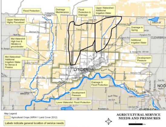
6 Characterizing & Mapping: WHERE

7 Characterizing & Mapping: WHERE


8 Strategic location of protection/enhancement sites Water Flow Model Results o o o Protection Restoration Less Impact to Processes Model 1 Model 2


9 Overall Results for Water Flow Process Importance Map Based on precipitation type and quantity, and area contributing to storage, recharge, and discharge processes Impairment Map Based on loss of forest, reduction in storage, recharge, and discharge and increase in impervious cover Darker Blue = Higher Importance to Water Flow Process Darker Red = Greater Impairment to Water Flow Process 9


10 Overall Results for Water Flow Process Synthesis Map 10
11 Ecosystem wide characterization Fishtrap Creek Ecosystem Issue Fishtrap Creek and Tributaries How have ecosystem processes been changed relative to issue? Solution Actions: Recommended protection & restoration measures and environment designations Low Dissolved Oxygen. On 303 (d) list. Delivery, storage and discharge processes have been impaired. These processes govern denitrification and removal of sediment and phosphorous. Impaired delivery results in greater movement of sediment and phosphorous into aquatic systems. Impaired storage and discharge reduces denitrification processes Restore depressional wetland areas downstream of agricultural lands. Develop mitigation bank run by agricultural community. Proceeds from sale of credits would be used to retire development rights in agricultural lands at highest risk of development.


12 Potential Restoration Area Fishtrap Creek Potential Mitigation


13 Potential Restoration Area Fishtrap Creek
14 GI Process will help us: Better identify and protect our working lands and the physical infrastructure they need; Strategically locate lands to produce environmental services our community needs for a healthy watershed; Facilitate an environmental market place to provide more income to farmers; Reduce conflict among farmers, environmentalists, developers, tribes and community members; Deliver certainty that we will make wise use of resources for present and future generations.
15 Credits/Resources Whatcom Co Ag-Watershed Project Website: agprogram/index.jsp o FHB Consulting (Heather MacKay, mackayh@gmail.com) o Whatcom County (Karin Wessman, KWessman@co.whatcom.wa.us) Puget Sound Watershed Characterization Website: cterization.htm o Washington Dept. of Ecology (Stephen Stanley, SSTA461@ECY.WA.GOV) Farm Friends: