|
|
|
- Edwina Wheeler
- 5 years ago
- Views:
Transcription

1 January 2015
 seeks to preserve, protect and enhance the living resources of the state.")
2 Larry Hogan Governor Boyd Rutherford Lt. Governor A message to Maryland s citizens The Maryland Department of Natural Resources (DNR) seeks to preserve, protect and enhance the living resources of the state. Working in partnership with the citizens of Maryland, this worthwhile goal will become a reality. This publication provides information that will increase your understanding of how DNR strives to reach that goal through its many diverse programs. Tawes State e Building 580 Taylor Avenue Annapolis, Maryland Toll free in Maryland: 1-(877) DNR ext Out of state call: TTY via Maryland Relay: 711 (within MD) (out of state) THE FACILITIES AND SERVICES OF THE MARYLAND DEPARTMENT OF NATURAL RESOURCES ARE AVAILABLE TO ALL WITHOUT REGARD TO RACE, COLOR, RELIGION, SEX, SEXUAL ORIENTATION, AGE, NATIONAL ORIGIN, OR PHYSICAL OR MENTAL DISABILITY. This document is available in alternative format upon request from a qualified individual with a disability. Publication # Published January 2015 PRINTED ON RECYCLED PAPER
3 Maryland Stream Waders Volunteer Stream Monitoring Manual Compiled by Daniel Boward, Rita Bruckler, Sara Weglein, and Luke Roberson Revised January 2015 Maryland Department of Natural Resources Monitoring and Non-Tidal Assessment Division 580 Taylor Avenue; C-2 Annapolis, Maryland
4 This page intentionally left blank 2
5 Contents Welcome to Stream Waders... 4 Site Selection and Landowner Permission... 7 Safety... 8 Stream Survey and Benthic Sampling... 9 Equipment and Sample Retrieval and Chain of ustody Equipment and Supplies Quality Assurance/Quality Control Appendices Appendix I - Example Subwatershed Maps Appendix II - Site Survey Form Appendix III - Decontamination Procedures Appendix III - Chain of Custody Form Appendix IV - How to contact Stream Waders
6 Welcome to Stream Waders Thank you for joining Maryland Stream Waders, sponsored by Maryland Department of Natural Resources (DNR) Monitoring and Non-tidal Assessment Division. The year 2000 was the inaugural effort for this statewide volunteer stream monitoring program, with more than 200 volunteers sampling over 700 sites statewide. We ve now made statewide stream volunteer monitoring an annual activity and an integral part of DNR s professional stream sampling program, the Maryland Biological Stream Survey (MBSS). The Maryland Biological Stream Survey is a statewide program to monitor and assess the chemical, physical, and biological quality of small to medium sized freshwater streams. Results from the MBSS are used for reporting stream conditions, researching the relationships between watershed conditions (such as land use) and the quality of the streams that drain them, and most recently, for water quality regulations. The U.S. Environmental Protection Agency is recommending that the MBSS serve as a National model for other state s stream monitoring programs. Begun in 1995, the MBSS has sampled well over 3,000 stream sites in Maryland. But we need to do more. That s where you come in! One important goal of Stream Waders is to increase the density of stream sampling sites beyond the capabilities of DNR staff. During the first round of the MBSS ( ) DNR sampled an average of 7 stream sites per medium-sized watershed (about 80 square miles) and in 2000, thanks to Stream Waders, this number increased to 10. With the help of volunteers like you, we hope to increase this number to more than 25 sites per watershed! 4
7 The goals of Maryland Stream Waders are: To increase the density of sampling sites for use in stream quality assessments To improve stream stewardship ethics and encourage local action to improve watershed management To educate the local community about the relationship between land use and stream quality To provide quality assured information on stream quality to state, local, and federal agencies, environmental organizations, and others. What is the volunteer ommitment? DNR is recruiting volunteers from across Maryland to help with the program. Two commitments from volunteers are needed: 1) attendance at a Saturday training session held during February or March, and 2) commitment to sample up to 12 sites (one time only) anytime during the March-April sampling season. This will require about 2 days of work and can be done with a friend or you can join a team at the training session. What s the watershed connection? The fairly small subwatersheds (about 8 square miles each) to be sampled by Stream Waders are the primary sampling units of the program and our goal is to sample each of them during the spring. These subwatersheds are also parts of the larger watersheds being sampled by MBSS crews from DNR and the University of Maryland. Thus Stream Waders data will be quite compatible with those collected by MBSS. What s being sampled? Benthic macroinvertebrates (aquatic insects, crustaceans, snails, etc.) will be sampled using the same methods and sampling window (March and April) as that used by MBSS crews. Samples will be preserved in the field and identified by DNR benthic taxonomists at the DNR field office in Annapolis. How will sample results be made available? DNR staff will provide results of all sampling on its Web site, via or through regular mail to those volunteers wishing to have them. All efforts will be made to have these results available in a timely manner (usually within 12 months of collection). 5
8 What are the steps needed to complete Stream Waders sampling? 1) Attend a training session offered in February or March 2) Sign a volunteer form for insurance purposes 3) Sign out your collection equipment and supplies at the training session 4) Choose subwatersheds for sampling During your training session, you will be asked to choose subwatersheds (about 8 square miles each) to sample within the selected watersheds for this year. 5) Identify DNR/County priority sites or choose sites in each sub-watershed 6) Get permission to sample from any private landowners 7) Sample! You may sample anytime during March and April. 8) Arrange for delivery of samples, forms, and equipment to DNR or bring them back to your training site at noon on the first Saturday in May unless your trainer makes other arrangements. 6
9 Site Selection and Landowner Permission Sites should be sampled upstream of a road crossing or within a short walk from a road, if possible. Color topographic maps with streams, roads, and subwatershed boundaries will be available. These maps also show the locations of public (state or county owned) lands. Copies of ADC road maps will also be included in your map package (NOTE: there are no ADC maps available for Garrett, Allegheny, or Somerset counties; United States Geological Survey maps will be used for these counties; see Appendix I). After identifying which subwatershed(s) you wish to sample, select your sites in the following ways: First, sample sites recommended by DNR. Recommended sites, such as those requested by county agencies, will be identified at the training sessions. Second, if there are no recommended sites in each of your subwatersheds, sample one site at or near the most downstream bridge in the subwatershed. If there are certain streams that are of interest to you, you may choose to sample in these areas. Private landowner permission forms will be included in your package. You must get permission from private landowners prior to sampling on their property. If you choose to sample on public lands, permission is not needed prior to sampling. However you should contact the park or State Forest ranger to let him or her know you re volunteering with Stream Waders. Note: if sampling on National Park property, talk to your trainer about acquiring the needed permits. 7
10 Safety is important to everyone. To have a successful and safe sampling expedition, caution should be used while sampling your stream site. Safety Guidelines Always take a buddy. Safety Be cautious of fast or deep waters. Do not sample if the water is dangerously fast. Wear shoes or waders that are in good condition and have traction. Never wear sandals or openfaced shoes. Do not use felt-soled waders. They are banned in Maryland. ALWAYS OBTAIN PERMISSION TO CROSS PRIVATE PROPERTY TO GET TO A SAMPLING SITE. Be sure that the landowners know exactly when and where you will sample. Contact your nearest health department or Maryland Department of the Environment [(410) ] for specific warnings regarding local streams. Some stretches of streams may be subject to high levels of pollutants. Leave wildlife alone. Do not disturb the vegetation on the streambanks or feed wild animals. Bring a change of clothes in case you get wet. Stream water is usually quite cold in March and April. Watch traffic while parking near your sample site and getting in and out of your car. Display your DNR Stream Waders logo prominently on your windshield. Avoid getting ethanol (the preservative for your samples) on your skin. If you do, wash immediately with plenty of water. Make sure all alcohol containers (carboy and benthic sample buckets) are tightly sealed and stored securely in your car during transport. 8
11 Stream Survey and Benthic Sampling Although DNR will use benthic community data to report on the overall quality of the stream, it is important to gather some other information that may help us identify the location of your site and to understand why the stream was rated as it was. Upon arrival at your sampling site, turn on your GPS unit (push the PWR button). IMPORTANT!!! BE SURE TO ACQUIRE A NEW SATELLITE LOCK EACH TIME YOU BEGIN A NEW SITE. The unit should be placed in a secure but open area. If the unit does not see at least three satellites after about 5 minutes, move it to another place and continue trying. If the unit fails to see at least 3 satellites at the end of your sampling, be sure to give a good description of the sample site on the Comments Form. Refer the GPS Directions handout and the Manual for details on how to use your unit. NOTE: the GPS unit provided by DNR is preset to the coordinate system NAD 83/WGS84. Use your GPS unit to record the latitude and longitude of your sampling site. Try to take the readings within 150 feet of where you sample for benthos. The best readings are made where there are no overhead obstructions such as trees and tall buildings. If necessary, you may take the readings on the side of the road near the sample site. Watch traffic! Observe the stream conditions upstream of the bridge (if you are sampling at a bridge). Has there been a storm lately? Is the stream exceptionally high and fast? If so, you may wish to revisit the site later. Do not sample if the water is dangerously fast! If possible, approach your sample site from downstream. Do your best to choose a sampling area that is uninfluenced (or minimally influenced) by any nearby roads. For example, try to sample upstream of the right-of-way along the bridge that most likely has no tree cover. Choose a small section of stream (about 100 feet) from which to sample. Overview of Benthic Sampling The intent of benthic sampling is to obtain a sample most representative of the best available habitats within your sample section. The sample collection will allow for the calculation of a Benthic Index of Biotic Integrity (B-IBI) to be used to assess the health of the sampled stream. 9
12 Sample Period The standard sampling window is March 1 through April 30. This is the same sampling window for all MBSS benthic collections. Habitats to be Sampled A combination of habitats supporting the most diverse macroinvertebrate community within a sample section will be sampled in proportion to their occurrence. Habitats to be sampled are: riffles rootwads/woody debris/leafpacks submerged aquatic vegetation undercut banks Riffles in the mountain and piedmont regions will likely have boulder or cobble stones, while those in the coastal region will likely have gravel or sand. Taking Your Benthic Sample First, be sure that your net and sieve bucket have no holes or remnants of the previous sample. If either has holes, repair them before sampling! Label the sample bucket with your name, the subwatershed number, the site number, and the sample date. Two labels are used with each sample: 1) an adhesive label goes on the outside wall of the bucket (not on the lid!) and 2) another label goes into the bucket on top of the sample and preservative. Have your teammate verify the correctness of the labels and indicate so on the survey sheet. Survey the stream section to locate the most productive habitat(s) from the list above. Sample each habitat in proportion to its prevalence at the site. For example, if your site contains a large, well-developed riffle with a few undercut banks containing root mats, sample mostly riffle (80%) and some root mats (20%). If sampling a riffle, start at the downstream edge and place the net firmly in the substrate. Disturb the substrate with your feet in an area the width of the net and, at most, two net widths upstream. Rub by hand any large sticks and/or stones from the disturbed area to dislodge any tightly-clinging organisms. Repeat this process at the upstream edge of the riffle. Because benthic community composition is known to vary with stream velocity and substrate size, try to sample the range of substrate types and velocities found within the riffle. CAUTION: When disturbing and removing substrates, be aware of the possibility of sharp objects such as broken glass. When sampling woody debris, rub the surface with your gloved hand. If the debris is small enough, place it in your net as you rub it down. If it is too large to fit in your net, hold the net down stream of the area you are rubbing, rub the surface and then sweep the net past the debris 10
13 to catch any organisms that may have been dislodged into the water column. When sampling leaf packs, one handful of leaves is approximately 1 square foot. Be sure to choose old, partially decomposed leaves, not freshly fallen leaves. Place the leaves in your D net to be processed in the sieve bucket later. To sample rootwads and submerged aquatic vegetation, the D net should be used in a jabbing/ sweeping motion to dislodge organisms. Kick the habitat prior to jabbing to dislodge organisms. In soft substrates, the net motion should be more gentle to minimize the collection of detritus. Undercut banks have been carved out by the water s force. They are typically composed of rock embedded in firm soil or hardpan and they may have rootwads or roothairs associated with them. Please note that undercut banks are composed of rock or soil, not living material such as roots. Undercut banks are the LEAST DESIREABLE of all preferred habitats. When a 20 square foot sample has been obtained, or when the D net becomes filled to the point that water does not pass easily through it, the net should be washed into the sieve bucket. While the sample is in the sieve bucket, all large stones, debris, leaves, etc., should be carefully washed, inspected for organisms, and discarded. Try to put as little material as possible into the sample bucket (remove rocks, sticks, and leaves). Also, while rinsing the sample in the sieve bucket, remove salamanders and fish that may have been swept into the net during sampling. Transfer the sample to a labeled (see below) sample bucket and add an amount of alcohol about equal to the sample volume. At each sample site, benthic collection alone should not exceed 15 minutes. The lid to the sample bucket should be tight (after proper labeling) and the sample readied for transport. Verify that the D net is clean and clear of clinging organisms. Labeling Your Benthic Sample Container Proper labeling of your benthic sample is critical! If the container is rendered unidentifiable for 11
14 whatever reason, the sample may not be used. The denatured alcohol used to preserve the samples is an excellent solvent! USE A PENCIL! Sample bucket labels are preprinted with the information above. Use the following convention when labeling your sample buckets: Sampler Name(s): Write the first and last names of each member of the sampling team. Site Number: In the four squares labeled Subwatershed number, write the unique four digit number that corresponds to the Subwatershed containing the stream you are sampling (that is, the last four digits of the entire 12-digit subwatershed number). This number is indicated on the laminated color topographic map of each Subwatershed. In the two squares labeled Site Number, indicate which site you are sampling within the corresponding subwatershed (you assign the numbers beginning with #1). For example, if you are sampling within subwatershed # 0341, and you sample three sites within that subwatershed, your site numbers will be: , , and DNR staff will later assign a site code to each of your samples. Sample Date: Write the date (YY/MM/DD) you collect the sample. Complete two labels for each bucket. Place one inside the bucket on top of the sample material and affix the other to the outside wall of the container using the adhesive preprinted label provided. NOTE; it is best to affix the outside label prior to collecting the sample, as the label will not stick as well if the bucket is wet. If you know where and when you will be sampling before you leave home, you may label your buckets in the comfort of your living room. After taking your benthic samples and filling out all your Site Survey Forms, you have two choices for transfer of your samples and equipment to the DNR laboratory in Annapolis: Deliver your samples and equipment to your training site at noon on the first Saturday in May unless your trainer makes other arrangements and a DNR representative will be there to meet you. 12
15 Equipment, Sample Retrieval, and Chain of Custody Call the Stream Waders hotline to make arrangements to deliver your samples and equipment to our field office in Annapolis or to a more convenient location. During your visit to the field office, you will be given a tour of the benthic macroinvertebrate laboratory and get a first hand look at how DNR processes and identifies these creatures. Prior to your samples being transferred to DNR, please keep the buckets in a dry place out of doors, such as in a garage. Store the equipment in a safe and secure place. When you transfer your samples, make sure your Chain of Custody Form is filled out according to the instructions in Appendix III. This form must be transferred to the person receiving your samples. 13
16 Equipment and Supplies Each team of Stream Waders volunteers will be provided with the following equipment and supplies at the training sessions: GPS (Global Positioning System) unit (1) D net (1) Sieve bucket (1) Benthic sample buckets with lids (*) Paper labels for benthic sample buckets (*) Carboy with about 5 gallons of alcohol (1*) Waterproof Site Survey Form (*) Land owner permission letter (*) Letter for landowners interested in more information (*) Laminated map of sampling subwatershed (*) Photocopy of street maps of sampling subwatershed area (*) Round color stickers for labeling sites on laminated maps (*) Pencil for labeling benthic samples (1) Clipboard (1) Site Survey Form (*) Chain of Custody Form(*) Stream Waders hat (1 per person) Windshield sign (1) Rubber Gloves (1) Bleach spray bottle (1) Bottle of bleach to mix to 10% in spray bottle (1) (*) indicates number of item will vary according to the number of sites sampled. 14
17 In the Field At least one person from each sampling team must receive training from DNR biologists. A subset (5%) of sites collected by Stream Waders will also be sampled by DNR biologists or other Stream Waders who agree to perform this QA/QC task. Follow-up analyses will indicate comparability in sample findings. In the Lab Quality Assurance/Quality Control All samples will be subsampled and identified at DNR s benthic laboratory in Annapolis by trained sample processors and taxonomists. All subsampled organisms, sample sortate, and vouchers will be retained at the DNR laboratory. Data Entry and Management Once identified, site taxa lists will be entered into the same database as that used for the MBSS. The same quality control checks will apply to both data sets. Stream Waders data will be maintained at DNR in the same file format as those for the MBSS and will be available on the Stream Waders website. 15
18 This page intentionally left blank 16
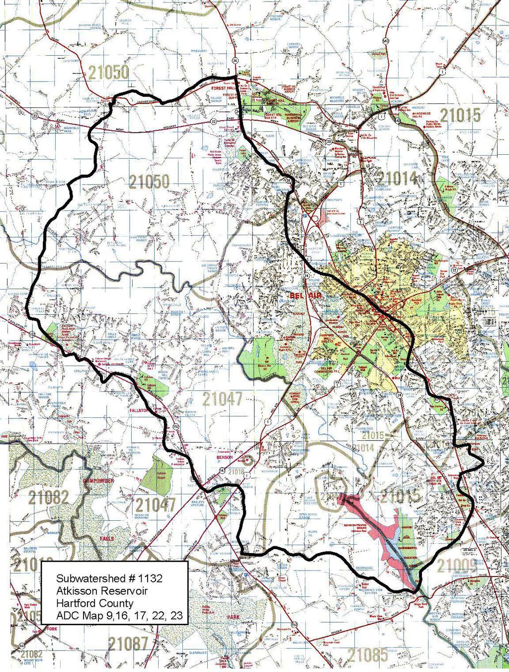
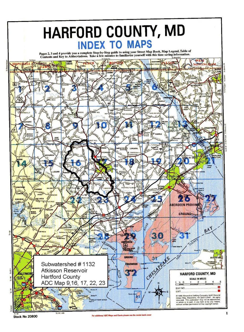
19 Appendix I Subwatershed Maps This set of two maps is an example of the map package used by Stream Waders volunteers to locate sample sites. The first map is a portion of a 1 = 2,000 (1:24,000) scale ADC road map showing the outline of the 12 Digit subwatershed (#1132; bold black line) to be sampled. The legend also contains the name of the 8-digit watershed, the county or counties containing the subwatershed, and the map number(s) from the ADC road map containing all or portions of the subwatershed. Please note that any adhesive blue dots on your maps represent special sites requested for sampling by county agencies. Maps distributed at training are in color and laminated. The second map is for referencing the corresponding ADC book map pages containing the subwatershed. During training, additional maps of individual ADC road maps will be distributed with each subwatershed map package to aid in locating roads, streams, public lands, etc. Please be sure to return your maps to DNR when your samples and equipment are returned. Note: For those of you sampling in Garrett, Allegheny, and Somerset counties: There are no additional maps of individual ADC road maps for these counties. Your map packages include a set of two maps. One is the color prints of a portion of a 1 = 2,000 (1:24,000) scale ADC road map showing the outline of the 12 Digit subwatershed (#1132; bold black line) to be sampled. The other is an index map of the entire state with the grids that contain the watershed highlighted. 17
20 18
21 19
22 This page intentionally left blank 20
23 Appendix II The Site Survey Form is intended to provide key information about the location and basic description of each sample site. Since DNR will incorporate spatial data (latitude and longitude) into the MBSS database, it is essential that these readings be accurate. Also, please be as accurate as possible in your descriptions of each sample site. DNR will use the non-biological information you collect (such as stream width, etc) to provide insight into why the benthic community is healthy or not healthy. Please thoroughly read the following guidance below before filling out the Site Survey Form. Use the Comments section to jot down any unusual condition in the stream such as strange odors or water color, large algae growths, discharges into the stream, high flows, extremely turbid water, enough trash to warrant a cleanup, etc. Note activity on the land near the stream such as cows grazing in or near your site, construction, etc. you may also wish to simply describe the beauty of the stream. In this space, please note why you sampled at this site. For example you may specify that your watershed organization would like information on the health of your sampled stream, or that this was a site recommended by DNR. Your comments may provide DNR with valuable insight into potential stream impairment sources or information on high quality streams. Feel free to use extra paper to jot down more comments. Please use a sharp pencil to complete the Site Survey Form. COMPLETE THE ENTIRE FORM. Write legibly and complete as many fields as possible. If an entry for a field is not known, place a strike-through line above the underline on the Form (e.g., County ). Site Survey Form Verification (upper right corner) Initials Reviewer Place the initials of the person filling out the form on the line labeled Initials Place the initials of the person reviewing the form on the line labeled Reviewer Names of Samplers Enter the full names of each person on your Stream Waders team. NOTE: at least one member of the team must complete a training session. Stream Name (If Known) Site Survey Form Enter the most likely name of the stream you are sampling. Names may be obtained from the ADC, DeLorme or the topographic map provided. If the stream name is unknown, but you know the name of the next stream downstream, call your stream Unnamed Tributary to... (name of next stream downstream). Site Number (Subwatershed Number Plus Sequential Number) Enter the number of your Subwatershed (from the color topographic map). Sequential numbers usually are 1 through 3. For example, if you are sampling the third site in Subwatershed number 0433, your Site Number will be
24 Date Sampled Time Latitude Longitude Enter the sampling date in the format noted (YY/MM/DD, where Y is the two digit year, M is the two digit month, and D is the two digit day) Enter the time using hours only and circle either AM or PM. Enter the latitude of your site from your GPS unit in Degrees, Decimal Minutes, as indicated. Make sure the GPS unit is showing the latitude/longitude for the new site. Enter the longitude of your site from your GPS unit in Degrees, Decimal Minutes, as indicated. Nearest Road/or Intersection County Enter the name of the nearest road (at the bridge or closest to your site) using the ADC or DeLorme map. If your site is near an intersection, enter Road A X Road B (e.g., Smith Lane X Taylor Ave.). Enter the name of the county containing your site. Map Grid (ADC or DeLorme Map and Grid) Enter the map (e.g., 8) and grid (e.g., D-6) containing your site from the ADC Map if available. Stream Depth (Centimeters) Using your D net handle, measure the approximate depth of the stream in a place that you think is most representative. The black marks on the D net handle are 5 centimeters apart. Average Stream Width Circle the appropriate size (Small, Med., Large) using the following criteria : Average stream width less than 10 feet = Small Average stream width between 10 and 30 feet = Medium Average stream width greater than 30 feet = Large If you wish, you may use your D net to measure the approximate width of the stream in meters. Take your measurement in a place that you think is of average width. The total length of your net is 5 feet and the black marks on the handle are 5 centimeters apart. Otherwise you may simply pace off the distance or visually estimate the width. 22
25 Benthic Habitat Sampled (total=20 square feet) Indicate in square feet which benthic habitats were sampled at your site. The total should be 20. For example, if your site contains mostly riffle and a few undercut banks with root wads, sample about 18 (enter 18; one digit per box) square feet of riffle and 2 (enter 02; one digit per box) square feet of root wads. Sample your habitats according to their approximate proportion at your site. If you sample habitats other than those listed, enter them in the blank labeled specify here. 23

26 BE 24

 the portion of your waders, D net and sieve bucket that contacted stream water.")
27 Maryland Stream Waders Decontamination Procedures The purpose of this procedure is to guard against the spread of potentially harmful invasive plant and animal species that can be transported from one stream to another. Examples include Didymo and the parasite that causes whirling disease 1. While at home, make a 10% solution of bleach and tap water using the bottle of fullstrength bleach and the spray bottle provided (see marks on the spray bottle). The provided gloves may be used for this. 2. After sampling your first site for the day, spray (liberally) the portion of your waders, D net and sieve bucket that contacted stream water. DO NOT RINSE THESE ITEMS. 3. Prior to leaving the first site, place your waders, sieve bucket, and net (the part that contacted the water) into the trash bag provided. Seal the bag as best as possible for transport. 4. Upon arrival at the next site, remove your equipment from the bag and rinse with tap water (you ll need to provide a spray bottle with tap water) or rinse by the stream with stream water. You can use an empty benthic sample bucket to scoop stream water. STEP AWAY FROM THE STREAM BEFORE YOU RINSE AND USE CAUTION TO PREVENT BLEACH FROM ENTERING THE STREAM. 5. Repeat steps 2-4 for subsequent sites sampled throughout the day. It is not necessary to decontaminate between sites if you are sampling two or more sites consecutively on the same stream. Didymo Whirling Disease Parasite 25
28 This page intentionally left blank 26
29 Appendix III Chain of Custody Form Use the Chain of Custody form to keep track of the transfer of your benthic samples from one person to another. Each form has enough space for 20 samples. Enter the site number (subwatershed number followed by sequential number; e.g., ) in the first column for each of your samples being transferred. Use one row of the table for each sample bucket. Place your first initial and last name in the Delivered by column and have the person to whom you are delivering the samples place his or her first initial and last name in the Delivered to column. Use the space at the end of the form (back side) to record any comments you may have regarding your samples or their transfer. For example, you may note that sample has a small crack in the lid. This will alert the recipient of any potential problems with the sample. 27
30 Date Delivered by Delivered to Date Private Landowner Permission (T) Sampled on Public Property (T) Chain of Custody Form Maryland Stream Waders Site Number Delivered by Delivered to Required Information Sampler=s Initials 28 Comments
31 Appendix IV Contact DNR Stream Waders Use the following information to contact DNR Stream Waders staff or to get periodic updates on the Stream Waders program. Stream Waders Telephone Hotline: (Annapolis local number) DNR [extension 8623] (toll free in Maryland) Connect with Stream Waders on the Web: For general information on the Stream Waders Program, go to: To check out the Stream Waders searchable database, go to: Like us on Facebook! on Twitter! 29