The European Water Framework Directive and its potential relevance for Water Management in the Lower Mekong Basin. Study prepared on behalf of GTZ
|
|
|
- Hillary Weaver
- 5 years ago
- Views:
Transcription
1
2 The European Water Framework Directive and its potential relevance for Water Management in the Lower Mekong Basin Study prepared on behalf of GTZ PN: VN: Prepared by ITTrms e.v Authors: Lars Ribbe Udo Nehren Alexandra Nauditt Nicole Kretschmer Sandra Alfonso de Nehren Alexandra Hann 1
3 Content 1. Introduction Outline of the EU WFD Background Objectives and key elements A brief guide to the text and annexes of the WFD Implementation process of the WFD River Basin Management Cycle River Basin characterization and analysis Monitoring Economic Analysis Program of Measures Public Participation and Reporting Case Study: Implementation of the WFD in the Danube River Basin The following steps have been done in order to solve the significant water management issues: Working scale within DRB Plan Definition of Sub-Basin and Sub-Unit Roof Report Major Instruments used for the WFD implementation Information sharing and management Guidance Documents The Pilot River Basin Exercise Relevance of the WFD in the Lower Mekong Basin context Setting a clear and common objective Clearly defined roles Common legal framework Use common definitions and standards Specific tools and instruments Assistance to capitalise on the experiences of the WFD Final remarks References Annex
4 List of Tables Table 1: Broad classification by driving force of pressures Table 2: Classes of impacts that can be identified by monitoring data Table 3: The DPSIR framework as used in the pressures and impact analysis Table 4: Major WFD deadlines in the timetable for the identification and designation of HMWB and AWB in the first planning cycle) Table 5: Required maps to report on to the Commission with categories of the related GIS layers Table 6: Key actions of the Member States according to GD 10, page 6 (shortened) Table 7: DPI relationships and wetlands Table 8: Proposed areas of work (** not yet communicated) List of Figures Fig. 1: Overview of the planning process according to the WFD Fig. 2: Schedule of WFD implementation Fig. 3: Water body categories according to the WFD Fig. 4: Suggested approach to determine reference conditions Fig. 5: Classes of Ecological Status and Ecological Quality Ratio (EQR) Fig. 6: Priority Substances Fig. 7: Schematic presentation of the role of pressure and impact analysis Fig. 8: Role of monitoring for surface water bodies according to the WFD (GD 7, p. 11) Fig. 9: Role of monitoring for groundwater bodies according to the WFD (GD 7, p. 11) Fig. 10: The explicit economic functions of the economic analysis Fig. 11: The implicit economic functions of the economic analysis Fig. 12: Different forms of public participation Fig. 13 Organisational structure under the Danube River Protection Convention Fig. 14: Initial structure of CIS working groups Fig. 15: Organisational structure of current CIS approach Fig. 16: Example of groundwater flows between two RBDs Fig. 17: left: Baseline on Majorca Island, right: Baseline on the Catalan coast Fig. 18: Example of an assignment of coastal water streaches to RBDs Fig. 19: A Bird s View to the Three-Step Approach Fig. 20: Identification of water bodies Fig. 21: Summary of suggested hierarchical approach for the identification of surface water bodies Fig. 22: Definition of aquifers Fig. 23: Subdivision of aquifers Fig. 24: Summary of the suggested hierarchical approach to the identification of bodies of groundwater Fig. 25: Requirements for impact analysis for surface and ground waters, specified by the WFD
5 Fig. 26: Illustration of the DPSIR analytical framework, note: the response is not considered in this guidance Fig. 27: Needed steps to derive a selected list of pollutant Fig. 28: Steps of the HMWB & AWB identification and designation process Fig. 29: Structure of the guidance for the process of intercalibration Fig. 30: Selection of intercalibration sites for the intercalibration network Fig. 31: Quality elements (QE) suggested for determining the status of rivers Fig. 32: Summary of purposes of and requirements for groundwater monitoring programmes specified in Annex V of the Directive Fig. 33: The role of conceptual models for groundwater monitoring Fig. 34: Outputs of risk assessment, surveillance and operational groundwater monitoring Fig. 35: Contents of the document concerning Public Participation Fig. 36: Timetable for implementation of parts of the WFD which are depending on Guidance from WG 2.3 (REFCOND) Fig. 37: Indication of the relative roles of biological, hydromorphological and physico-chemical quality elements in ecological status classification according the normative definitions in Annex V: Fig. 38: Basic principles for classification of ecological status based on Ecological Quality Ratios Fig. 39: Interdependency of water bodies and wetlands and its reference to the WFD Fig. 40: Indication of the relative roles of biological, hydromorphological and physico-chemical quality elements in ecological potential classification according the normative definitions in WFD Annex V: Fig. 41: Examples of how indicative parameters may be combined to estimate the condition of the biological quality-elements Fig. 42: The establishment of ranges and levels for the physico-chemical quality elements at good ecological status/potential. Cases (a) and (b) should be recognised, but from practical reasons it is proposed to establish only one range or level including both aspects Fig. 43: Checking procedure for assessing whether a level or range established for a general physico-chemical quality element is more stringent than required by the WFD, according to the normative definitions of ecological status/potential Fig. 44: Checking procedure to assess whether a level or range established for general physico-chemical quality element is insufficiently stringent to meet the Directive s requirements, according to the normative definitions of ecological status/potential.. 91 Fig. 45: Elaboration of second box in the good status/potential line of the ecological classification diagrams List of thematic boxes Box 1: EU water related Directives...7 Box 2: International conventions that need to be considered for WFD implementation or played a role in drafting the WFD...8 Box 3: Instruments of EU secondary legislation...8 Box 4: Integration as central concept of the WFD Box 5: Some Definitions of Water Bodies according to the WFD Box 6: List of possible supplementary measures suggested by the WFD
6 Abbreviations and Acronyms AWB CAP CIRCA CIS Artificial Water Body Common Agricultural Policy of the EU Collaborative workspace for partners of the European Institutions Common Implementation Strategy COAST Working group 2.4 on Transitional and Coastal Waters, GD 5 Commission Community Council EEA ELV EQS ENV ESTAT GD GEP GES GIS GML HMWB European Commission European Community European Council European Environment Agency Emission Limit Value Environmental Quality Standard European Union Environment Eurostat (reference centre for geographical information in the European Commission) Guidance Document Good Ecological Potential Good Ecological Status Geographic Information System Geography Markup Language Heavily Modified Water Body IMPRESS Working group 2.1 on Pressures and Impacts, GD 3 INSPIRE IRBD JRC MEP MS NGO Parliament PRB RBD RBMP Infrastructure for Spatial Information in Europe International River Basin District Joint Research Center Maximum Ecological Potential Member State of the EU Non Governmental Organisation European Parliament Pilot River Basin River Basin District River Basin Management Plan REFCOND Working group 2.3 on Typology, Reference Condition, GD 10 SWB Surface Water Bodies WATECO Economic Analysis Working Group 2.6, GD 1 WFD WISE Water Framework Directive Water Information System for Europe 5
7 1. Introduction T he Water Framework Directive (WFD) came into force in 2000 and is now the most significant water related legislation in Europe. It refers to the management of all water bodies throughout the Community. Even though the WFD has certain elements which are relevant merely in the context of the EU, it provides guidance on water management which could be useful in other regions of the world as well. This report intends to describe the WFD, the underlying principles, objectives, instruments and implementation methods and, based on this, to analyse to which extent these may be applicable to the Lower Mekong Basin. Objective of this report The present report aims at providing water managers an overview of the WFD putting them in a position to judge if certain elements could be useful in their respective country or river basin. It is written in such a way that it presents the essential contents of the WFD, the related technical support and further relevant documents. Each chapter provides multiple references where the reader finds detailed information, legal texts, etc. The main referenced documents, above all the full legal text of the WFD and the guidance documents, are included as annexes to this report. Guide to the content of this report Chapter 2 provides background information on the WFD and gives and overview of the key concepts of the Directive. At the end, a summary of all articles and annexes is provided so that the reader can quickly decide where it is worth to consult the original text of the WFD. Chapter 3 describes the implementation of the WFD, including all relevant steps of river basin characterization and planning. Many aspects are of general interest to any institution involved in river basin management planning. Issues that are specifically related to the EU context, such as references to other directives or policies, are not discussed in depth but just briefly mentioned. Chapter 4 gives an overview of the tools and instruments that the EU commission offers to support Member States in implementing the WFD. These deal with information sharing and management, technical guidance, and pilot watershed studies. Each guidance document (GD) is summarized in order to provide the reader with the essence of technical guidance and to allow targeting the chapters of particular interest. In chapters 2-4 some issues may be repeated. This is intentionally so, since chapter 2 gives only a brief overview, while chapters 3 and 4 go more into detail and focus on certain aspects. Chapter 5 discusses the possible relevance of elements of the WFD for the Mekong River Basin. In this regard, only general statements can be made since a detailed analysis would require scrutinizing the current status of water related legislation and the institutional landscape of all Mekong River riparian states. 6
8 2. Outline of the EU WFD 2.1. Background W ater legislation played an important role in the European Community since the mid 1970s as a response to often detrimental conditions of water bodies in all Member States. A large amount of directives to protect water resources was issued between 1975 and These include directives which laid down environmental quality standards (EQS) for specific types of water like drinking water, bathing water, shellfish water or established emission limit values (ELV) for specific uses of water like emissions to groundwater, fertilizer uses, dangerous substances, etc. Box 1 provides an overview of major water related EU directives. As a result, water quality throughout the Community improved significantly in the 1980s and 90s. Especially the concentration of pathogens, toxic substances and oxygen consuming organic contaminants were reduced in rivers and lakes, generally leading to an improved biological status. Nonetheless, in the 1990s environmental concerns remained high, since water quality did not reach good level in many community waters. On the other hand, the dual approach to water protection applying EQS on and ELV and the fact that by that time the water legislation was rather fragmented (20 EU Directives existed) led to several problems and contradictions in water policy implementation. Consequently, the demand for a policy reform, in the form of a common framework for water management was high and commonly agreed upon. Box 1: EU water related Directives Directives with focus on environmental quality standards (EQS) surface water intended for the abstraction of drinking water 75/440/EEC* Bathing water 76/160/EEC Freshwater Fish Directive 78/659/EEC** Shellfish Water Directive 79/923/EEC** Directives with focus on emission limit values (ELV) Dangerous Substances Directive 76/464/EEC** Daughter Directives of Dangerous Substances Directive: Mercury Discharges, 82/176/EEC, Cadmium Discharges 83/513/EEC, Mercury Discharges 84/156/EEC, Hexachlorocyclohexane Discharges 84/491/EEC, and Dangerous Substance Discharges 86/280/EEC Groundwater Directive 80/68/EEC** Nitrates Directive 91/676/EEC Urban Waste Water Directive 91/271/EEC Integrated pollution prevention and control (IPPC) Directive 96/61/EEC * directives which will be repealed in 2007 ** directives which will be repealed in 2013 Notes: The first number of each directive indicates the year when the directive was issued This is not a complete list of water related EU directives 7
9 In 1995 the EU council adopted a conclusion to develop a new framework directive establishing the basic principle of a sustainable water policy and invited the Commission to come forward with a proposal. This initial proposal was widely discussed involving the European Parliament, relevant stakeholders and expert groups. In 1999 a final proposal was agreed upon and passed the EU Parliament. On December 22 nd of 2000 the EU WFD came into force. Further activities related to EU water policy include several international conventions that were either considered in drafting the WFD or specifically mentioned in the WFD as necessary to consider during implementation (see Box 2). A brief overview of EU legislation is shown in Box 3. Box 2: International conventions that need to be considered for WFD implementation or played a role in drafting the WFD Convention Concerning the Protection of the World Cultural and Natural Heritage (UNESCO World Heritage Convention). Convention on Environmental Impact Assessment in a Transboundary context (ESPOO-Convention). Convention on International Trade in Endangered Species of Wild Fauna and Flora (CITES). Convention on Wetlands of International Importance especially as Waterfowl Habitat (Ramsar Convention). Stockholm Convention on Persistent Organic Pollutants (POPs Convention). UN/ECE Convention on the Protection and Use of Transboundary Watercourses and International Lakes. UNECE Convention on Access to Information, Public Participation in Decision-making and Access to Justice in Environmental Matter (Aarhus Convention) Note This is not a complete list of international conventions or agreements relevant in the context of the WFD Compare references for websites of the respective conventions. Box 3: Instruments of EU secondary legislation There are three types of European law: the primary legislation (the treaties), the secondary legislation and the decisions of the European Court of Justice and the Court of First Instance. The secondary legislation of the EU includes regulations, directives and decisions as binding, as well as recommendations and opinions as nonbinding legal instruments. While regulations and directives bind everyone, decisions only affect the parties to whom they are addressed (individuals, corporations, or member states). The difference between regulations and directives is, that the latter require implementation by national legislation to be effective, while the first are directly applicable, i.e. they are binding in and of themselves as part of national law. As the term implies, a framework directive is a sort of directive, which aims at a combined, coordinated and more integrative approach. Legally, there is no difference between a directive and a framework directive. Source: 8
10 2.2. Objectives and key elements The central objective of the WFD is to prevent further deterioration and to achieve at least good status 1 of all water bodies in all EU Member States. The units for water management are river basins and sub-basins, which are combined to river basin management districts. For each river basin management district a competent authority needs to be determined and river basin managements plans should be established specifying the measures needed to achieve the objectives of the WFD. Other key elements of the WFD are: It advocates an integrated approach to water management: - including all types of water bodies (surface and ground water, lakes, transitional and coastal waters); - combining quality and quantity elements; - combining emission and environmental quality standards; - using biological, chemical and quantitative elements of waters to determine its status; - dema nding complete phasing out of priority hazardous substances from the environment. It stresses to include economic, ecological, and social aspects in formulating water management plans. It demands to set up economic instruments (like cost recovery) as measures to reach environmental objectives and to use water efficiently. It aims at mitigating the effects of floods and droughts. It emphasizes the need to inform and involve stakeholders and the public. It gives clear deadlines for all major steps of the imp lementation of the WFD, thus, defining a binding road map for all Member States. It provides unambiguous guidelines and tools for all major elements of the water management cycle like watershed delineation and characterization, watershed assessment, economic analysis, classification, monitoring, river basin planning, etc. The central approach to the Water Framework Directive is the concept of integration that is seen as key to the management of water protection within the river basin district (compare Box 4). All Member States have to transpose the Water Framework Directive into their national legislation. Until 2006 all Member States except Italy and Luxembourg implemented the WFD at least partially (WFD scoreboard 2006). 1 The meaning of good status will be discussed below in chapter
11 Box 4: Integration as central concept of the WFD Integration of environmental objectives, combining quality, ecological and quantity objectives for protecting highly valuable aquatic ecosystems and ensuring a general good status of other waters; Integration of all water resources, combining fresh surface water and groundwater bodies, wetlands, coastal water resources at the river basin scale; Integration of all water uses, functions and values into a common policy framework, i.e. investigating water for the environment, water for health and human consumption, water for economic sectors, transport, leisure, water as a social good; Integration of disciplines, analyses and expertise, combining hydrology, hydraulics, ecology, chemistry, soil sciences, technology, engineering and economics to assess current pressures and impacts on water resources and identify measures for achieving the environmental objectives of the Directive in the most cost-effective manner; Integration of water legislation into a common and coherent framework. The requirements of some old water legislation (e.g. the Freshwater Fish Directive) have been reformulated in the Water Framework Directive to meet modern ecological thinking. After a transitional period, these old Directives will be repealed. Other pieces of legislation (e.g. the Nitrates Directive and the Urban Wastewater Treatment Directive) must be coordinated in river basin management plans where they form the basis of the programmes of measures; Integration of all significant management and ecological aspects relevant to sustainable river basin planning including those which are beyond the scope of the Water Framework Directive such as flood protection and prevention; Integration of a wide range of measures, including pricing and economic and financial instruments, in a common management approach for achieving the environmental objectives of the Directive. Programmes of measures are defined in River Basin Management Plans developed for each river basin district; Integration of stakeholders and civil society in decision making, by promoting transparency and making information accessible to the public, and by offering an unique opportunity for involving stakeholders in the development of river basin management plans; Integration of different decision-making levels that influence water resources and water status, be local, regional or national, for an effective management of all waters; Integration of water management from different Member States, for river basins shared by several countries, existing and/or future Member States of the European Union. Source: GD 1, page 5 10
12 Common Implementation Strategy (CIS) for the WFD The Common Implementation Strategy (CIS) supports the Member States in reaching the objectives of the WFD. The CIS offers information related to all relevant aspects of the implementation of the WFD on a website ( A series of guidance documents and other knowledge sources with technical information on specific topics are provided to support a harmonization of the implementation process. For that aim, working groups with participation of experts as well as relevant stakeholders from throughout the EU Member States have been established. In addition, a network of pilot river basins was created in order to validate the guidance provided by the CIS. Finally the CIS provides guidelines on information management to help Member States achieving a more targeted data and information collection, storage and access, to avoid duplication and ensure more efficient use of available data and information. Daughter directives The WFD requires the Commission to come up with measures to protect surface water and groundwater (articles 16 and 17). For that aim, currently two daughter directives are under preparation: a) on priority substances and b) on groundwater protection. As part of the WFD, a European Priority List of substances posing a threat to or via the aquatic environment has been established. There are currently 33 substances on this priority list (Decision No 2455/2001/EC), which was agreed in The list will be reviewed on a regular basis. These substances are referred to as Priority Substances, and those which are thought to pose the greatest threat are further identified as Priority Hazardous Substances. The daughter directive on priority substances is still under revision, it will probably contain specific Environmental Quality Standards (EQS) for the priority substances. A draft for the groundwater directive was proposed by the European Commission in September It aimed to clarify some of the objectives in the WFD - in particular, the meaning of good chemical status' for groundwater, the identification and reversal of pollution trends, and the control of pollution (Commission 2003). Streamlining of legislation: relation to other EU policies Obviously, there are several other EU policies that either have an impact on water resources or are impacted by the WFD. The analysis of pressures and impacts, for example, requires analyzing the impacts of diffuse sources and land use patterns on the status of water bodies. The consequences of identifying these pressures and, based on this, implementing corrective measures, requires to a large extent harmonization of the WFD with the Common Agricultural Policy (CAP). Further harmonization has to be achieved for policies mentioned in the preamble of the WFD: energy, transport, fisheries, regional policy, and tourism. A detailed description of these harmonization activities is beyond the scope of this report. Currently, the most notable efforts are undertaken to determine synergies between the WFD and the CAP (Ecologic 2005, EU Commission 2003). It is task of the Common Implementation Strategy (CIS) assuring that the linkages to other policies are established. Scope and limitations The EU WFD aims at all water bodies, i.e. groundwater, rivers, lakes, transitional, and coastal waters, as well as artificial and heavily modified water bodies. Here, a clear focus is to achieve good water quality. Other important elements that play a role towards achieving an integrated management of water resources, like water allocation or flood protection, are not directly covered by the Directive or only if there is a connection to the objective of achieving good status of water. Even though the level of integration (Box 4) is high the approach towards water management is still not holistic as it does not clearly demands establishing linkages to the broader ecological context or to other human activities like land use. The fact that wetlands are not explicitly mentioned in the WFD may be seen as an example of this limitation. 11
13 2.3. A brief guide to the text and annexes of the WFD The WFD consists of a preamble, 26 articles and 11 Annexes with detailed specifications. The following gives a brief overview of the Directive (for details see the original document in the Annex) Preamble The preamble of the WFD consists of 53 paragraphs. It lays down the basic principles of water management in the Community, refers to previous agreements that led to the development of the WFD, states the relation to other EU initiatives and regulations and points to international agreements and conventions related to the WFD Articles 1. Purpose Main objectives of the WFD are described, namely: prevent further deterioration and enhance status of all water bodies in the EU; achieve sustainable water management. 2. Definitions 41 terms of special importance for the WFD are defined. 3. Coordination of administrative arrangements within river basin districts The need to identify river basin districts, to determine administrative responsibilities and to coordinate in the case of international river basins with Member or Non-Member States is formulated. 4. Environmental objectives Member States shall protect, enhance and restore all bodies of water and implement the necessary measures to achieve this. Good status shall be reached in Special reference is made to surface waters, including artificial and heavily modified water bodies, groundwater and protected areas. Conditions under which Member States are allowed to exceed the deadlines for achieving good status or to achieve less stringent environmental objectives are defined. 5. Characteristics of the river basin district, review of the environmental impact of human activity and economic analysis of water use For each river basin district the following studies need to be prepared: analysis of the characteristics, impacts of human activities on water bodies, economic analysis of water uses; (year 4). 2 The years in this summary refer to the year after the date of entry into force of the WFD (2000). 6. Register of protected areas There is a need to establish a register of areas designated to require special protection for each river basin; (year 4). 7. Waters used for the abstraction of drinking water Water bodies that are used as source for drinking water (minimum 10³/day or 50 people served) shall be identified. There is an obligation to monitor water bodies where more than 100m³/day is used for human consumption. A reference is made to the Drinking Water Directive 80/778/EEC and amendment. 8. Monitoring of surface water status, groundwater status and protected areas Monitoring programmes need to be established, including i) water level/flow or volume, ii) chemical and iii) ecological status for surface water. For groundwater bodies the chemical and quantitative status shall be monitored. 9. Recovery of costs for water services Principles of cost recovery shall be implemented, including environmental and resource costs as measures to use water efficiently and to make sure that each water user contributes to the recovery of the costs of services. The economic measures within the river basin management plans need to be described. 10. The combined approach for point and diffuse sources All discharges shall be controlled according to best available techniques/best environmental practices and emission limit values. Where a quality objective or standard requires stricter conditions than those achievable by the use of BAT or emission limits, even stricter controls shall be introduced. References are made to directives on integrated pollution prevention, urban waste water treatment, nitrates and those listed in Annex IX. 12
14 11. Programme of measures Based on the analysis of Article 5, adequate measures need to be defined in order to meet the requirements of Articles 4 and 7. Basic measures include those required under other EU legislation as mentioned in Annex VI. This annex also includes a non-exclusive list of supplementary measures. Additional measures need to be taken if the set objectives are unlikely to be reached. This includes obligations to investigate the causes and to scrutinize, and if necessary to adapt existing legislation or standards. A programme of measures shall be established in year 9 (updated every six years). 12. Issues which can not be dealt with at Member State level Member States are asked to report if an issue cannot be resolved at national level. The commission needs to respond within 6 months. 13. River basin management plans (RBMP) RBMPs need to be defined for any river basin in the Member States until After that the plan should be revised every six years. Reference is made to Annex VII, where a detailed table of content for the RBMP is provided. For international river basins falling within the EU a single RBMP should be provided. 14. Public information and consultation Active involvement of all interested parties in the implementation of the Directive shall be encouraged. A timetable and a work programme of the RBMP should be made public at least three years before it starts. An interim report on water management issues has to be submitted two years, and a draft RBMP one year before the plan starts. Access to background documents should be provided on demand. 15. Reporting Each Member State needs to submit RBMPs and summary reports on the characterization of river basins and monitoring programmes to the commission at least three months after publication. Within three years after the publication of each RBMP an interim report describing the progress of implementation of measures shall be published. 16. Strategies against pollution of water The Parliament and Council should adopt specific measures against pollution of waters by specific substances. For this purpose the Commission should propose a priority lists of pollutants with a significant risk to or via the aquatic environment. These substances should be gradually reduced. Priority hazardous substances need to be defined and their emissions phased out. The Commission shall submit proposals for quality standards of priority substances in surface waters, sediments and biota. For this aim existing directives mentioned in Annex IX need to be reviewed. 17. Strategies to prevent and control pollution of groundwater The EU Parliament and Council should adopt specific measures against pollution of groundwater in order to support the achievement of good chemical status. The Commission should establish criteria for assessing good groundwater chemical status and criteria for the identification of sustainable upward trends. 18. Commission report The Commission shall publish a report on the implementation of the Directive at the latest 12 years after the date of entry into force and every six years after that and submit it to the EU Parliament and the EU Council. Specifications on what the reports of the Commission should contain are made. 19. Plans for future community measures Once a year the commission needs to present to the Committee (compare Article 21) planned activities that may have an impact on water legislation. At the latest 19 years after implementation the Commission reviews the WFD and proposes amendments, if necessary. 20. Technical adaptations to the directive There is a need to adapt annexes according to scientific and technical progress and to develop guidelines on implementation. 21. Regulatory committee A committee shall be established to assist the Commission according to Council Decision 1999/468/EC. 22. Repeals and transitional provisions Specifications are given on directives which will be repealed as a result of the WFD implementation. 23. Penalties Each Member State needs to define effective, proportionate and dissuasive penalties applicable to breaches of the national provisions that result from the WFD. 24. Implementation Member States need to bring into force the laws and regulations to comply with WFD before Entry into force The WFD enters into force on the day of publication in the Official Journal of the European Communities. 26. Addressees All Member States of the EU 13
15 Annexes of the WFD Annex I: Information required for the list of competent Authorities The following information on the competent authorities for each RBD needs to be reported to the Commission: i) name and address, ii) geographical coverage of RBD, iii) legal status of authority, iv) responsibilities, v) memberships (if authority acts as coordinating body), vi) international relationships. Annex II: Characterization of water bodies, pressures and impacts 1. Surface Waters 1.1 Characterization of surface water bodies The characterization of water bodies should include: location and boundaries of surface water bodies, categories (river, lake, transitional or coastal water), types of water bodies (according to system A or B, as defined below), special provision for artificial and heavily modified water bodies, a map showing extend and location of water bodies. 1.2 Eco-regions and surface water body types This section provides a framework to assign surface water body types according to two systems: based on eco-regions (system A) or based on physical and chemical factors (system B). If system A is used, reference should be made to the maps provided in Annex XI. 1.3 Establishment of type-specific reference conditions for surface water body types Physico-chemical, hydromorphological and biological conditions representing high ecological status shall be established for all water bodies using the quality elements defined in Annex V. Reference conditions may be defined through a network of existing sites with high ecological status or through modelling approaches. If both approaches are not applicable, Member States may use expert judgement to establish reference conditions. 1.4 Identification of pressures Information on type and magnitude of pressures need to be collected and maintained. Pressures are classified as: point sources, diffuse sources, water abstraction and recharge, morphological alterations, and land use patterns. 1.5 Assessment of impacts An assessment of susceptibility of the status of surface water bodies needs to be carried out to above mentioned pressures. 2 Groundwater 2.1 Initial characterisation The characterisation includes: location and boundaries of the groundwater body or bodies; pressures (diffuse and point sources, abstraction, and artificial recharge), general character of overlying strata, groundwater dependent ecosystems. 2.2 Further characterisation For those groundwater bodies being at risk to achieve good status a more detailed description needs to be provided including geological and hydrogeological characteristics, superficial deposits, recharge rates, etc. 14
16 2.3 Review of the impact of human activity on groundwater Where relevant, the following information shall be collected: Location and rates of abstractions from and discharges to the groundwater body, chemical composition of abstracted and discharged waters, and land use in the groundwater catchment area. 2.4 Review of the impact of changes in groundwater levels If good status of groundwater can not be achieved, the effects of the groundwater body on associated ecosystems, water regulation, flood protection, land drainage and human development need to be specified. 2.5 Review of the impact of pollution on groundwater quality Groundwater bodies, where achieving good chemical status is either infeasible or disproportionately expensive need to be identified. Annex III: Economic Analysis The economic analysis shall provide sufficient information necessary to account for the principle of cost recovery considering long term forecasts of supply and demand. It should make judgements about the most cost-effective combination of measures (Article 11). Annex IV: Protected Areas Types of protected areas are listed: i) areas designated for abstraction of drinking water, ii) to protect economically important species, iii) recreational and bathing waters, iv) nutrient sensitive areas, v) protection of habitats. Annex V: Surface and groundwater status, monitoring and presentation This annex covers 31 pages, the largest part are the normative definitions of ecological status classification. 1. Surface water 1.1 Quality elements for the classification of ecological status A list of biological, hydromorphological and chemical elements to classify ecological status is provided for all water body categories (rivers, lakes, transitional and coastal waters) and for artificial and heavily modified water bodies. 1.2 Normative definitions of ecological status and classification For each water body category, normative definitions are described for each element in order to judge whether the ecological status can be described as high, good or moderate. Water bodies showing evidence of major alterations from the reference conditions shall be classified as poor, water bodies with severe alterations as bad. Procedures for the setting of environmental quality standards for those chemicals listed in Annex VIII (points 1-9) are provided as well (1.2.6). 1.3 Monitoring of ecological status and chemical status for surface waters According to Article 8, surface water monitoring networks should be established and provide a coherent and comprehensive overview of the ecological and chemical status. They should permit to classify water bodies into five classes according to the normative definitions of section 1.2. Three types of monitoring are distinguished: Surveillance monitoring shall be established to provide information supplementing and validating the impact assessment (Annex II), used for efficient and effective 15
17 design of future monitoring programmes, assess long term changes of natural conditions resulting from anthropogenic activity. Operational monitoring shall be established in order to establish the status of those water bodies being at risk of failing their environmental objectives, assess changes as result of program of measures. Investigative monitoring shall be carried out where the reasons for any exceedance are unknown, where the objectives are not likely to be achieved and operational monitoring is not in place yet, to assess the impacts of accidental pollution. For surveillance and operational monitoring provisions for the selection of monitoring points and elements are made. Section deals with monitoring frequencies, with additional requirements for monitoring protected areas and refers to technical standards that should be applied during the monitoring processes (ISO, EN, CEN). 1.4 Classification and presentation of ecological status The classification of ecological status should be comparable for all water bodies and types. They should be expressed in numerical values between 0 and 1 ( high ecological status close to 1). The Commission shall facilitate an intercalibration exercise in order to establish comparability. Section provides details on this exercise. Section gives information on how to present monitoring results. The lowest value of any class of quality elements determines the overall value of that water body. Results should be presented in maps using specified classes and colour codes. 2. Groundwater 2.1 Groundwater quantitative status The main element for groundwater quantitative status is water level ; criteria to define good status are provided. 2.2 Monitoring of groundwater quantitative status Specifications are defined on groundwater level monitoring networks, density of monitoring sites, monitoring frequency and presentation of results; two classes are distinguished in reporting: good (blue), poor (red). 2.3 Groundwater chemical status Main parameters for groundwater chemical status are conductivity and pollutant concentration. Definitions of good status are provided. 2.4 Monitoring of groundwater chemical status Two types of monitoring are distinguished: surveillance and operational monitoring, specifications on parameter and site selection are provided. Monitoring shall permit the detection of long term trends of pollutants. Reporting should distinguish two classes: good (blue), poor (red). Values for a groundwater body or group of groundwater bodies shall be aggregated to a mean value. Downward trends shall be indicated by a black dot, upward trends by a blue dot. Annex VI: List of Measures to be included within the programme of measures Part A (basic measures) refers to comply with existing directives namely the Bathing Water, Birds, Drinking Water, Major Accidents, EIA, Sewage Sludge, Urban Wastewater, Plant Protection Products, Nitrates, Habitats, and Integrated Pollution Prevention Control Directive. 16
18 Part B provides a non-exclusive list of supplementary measures like legislative, administrative, economic or fiscal instruments, emission and abstraction controls, demand management measures, etc. Annex VII: River Basin Management Plans (RBMPs) Part A provides the required content for the RBMP: 1. General description of characteristics of RBD 2. Summary of significant pressures 3. Identification of protected areas 4. Map of monitoring network and results of monitoring activities 5. List of environmental objectives 6. Economic analysis 7. Programme of measures 8. Register of other, more detailed management plans for the basin or subbasin 9. Public information and consultation measures 10. List of competent authorities 11. Contact point for detailed information Part B contains specific provisions for the first and all subsequent updates of the RBMP. Annex VIII: Indicative List of the main pollutants The main pollutant groups are mentioned. Annex IX: Emission limit values and environmental quality standards Existing directives shall be considered in order to establish emission limits or environmental quality standards like 76/464/EEC, Mercury Discharges, Cadmium Discharges, Mercury, Hexachlorcyclohexane, and Dangerous Substances Discharges Directives. Annex X: Priority substances This annex was added in 2001 when the priority list was published. Currently 33 substances are identified as being of special concern regarding the pollution of the aquatic environment. 25 are classified as priority hazardous substances; for these more stringent measures need to be established. Annex XI: Maps of eco-regions Map of Eco-regions for rivers and lakes, according to System A Map of Eco-regions for transitional waters and coastal waters according to system A 17

19 3. Implementation process of the WFD 3.1. River Basin Management Cycle A ccording to the WFD, the River Basin is the planning unit for water management. The required steps of river basin management planning follow the objective to achieve good status in all water bodies by The following is a summary of the main steps of the WFD implementation: Define the limits of water bodies; determine River Basin Districts (RBD); Name a competent authority for each RBD; Characterize the water bodies within each RBD; Perform an economic analysis; Establish monitoring programmes; Assess the current status of each water body according to ecological and chemical (surface waters) or quantitative and chemical (groundwater) criteria and the risk to fail good status by 2015 using pressure and impact analysis; Determine a programme of measures for those water bodies at risk; Prepare coherent River Basin Management Plans (including RBD characterisation, economic analysis, assessment of status and program of measures); Implement the programme of measures needed to achieve good status ; Revise and update River Basin Management Plans 2015 and after that every six years. Crosscutting issues within the above mentioned planning process are public participation, i.e., an active information and involvement of the public and the establishment of information systems that allow to document, visualize, exchange and judge relevant information during the planning and implementation process. Each Member State is required to regularly report on the different steps of the implementation process to the Commission. Fig. 1: Overview of the planning process according to the WFD 18
20 Schedule and current status of implementation A distinguishable element of the WFD is the clear road map provided for each implementation step. As can be seen in Fig. 2, up to date (May 2006) the initial phases of implementation are accomplished: characterization and designation of river basin districts, economic analysis, reporting on protected areas. Other important elements of the implementation are yet to come, especially the definition of monitoring networks, the formulation of programmes of measures and the description of the first (2009) and subsequently revised River Basin Management Plans. This is important to note since related to the latter topics no final conclusions relying on experiences can be drawn from the WFD implementation yet. Introduce Water Pricing Policies (Art. 9) Continue Reviewing Water Pricing Policies Continue Reviewing Water Pricing Policies Continue Reviewing Water Pricing Policies Public Consultation on RBMPs (Art. 14) Continue Informing the Public About New Measures Continue Informing the Public About New Measures Continue Informing the Public About New Measures Establish Monitoring Networks (Art. 8) Monitor Network Programs Monitor Network Programs WFD Comes Into Force Designate River Basin Districts (Art. 3, 5) Finalize RBMPs (Art. 13) Ongoing Assessments of RBMPs Ongoing Assessments of RBMPs Ongoing Assessments of RBMPs Establish Program of Measures (Art. 11) Refine Program of Measures (Art. 11) Refine Program of Measures (Art. 11) Refine Program of Measures (Art. 11) Establish Protected Areas (Art. 6) Monitor Protected Areas Monitor Protected Areas Monitor Protected Areas Monitor Protected Areas Final Deadline to Legal Implementation Begins 6 Year Meet Environmental 1st Management Meet Objectives of WFD (Art. 23) Cycles of RMBPs Objectives (Art. 4) Cycle Ends (Art. 4, 13) (Art. 4, 13) Fig. 2: Schedule of WFD implementation Source unknown 3.2. River Basin characterization and analysis Boundaries of RBDs and competent authorities In the initial phase of the WFD implementation Member States were required to determine the boundaries of all surface and groundwater bodies in their territory. For trans-boundary watersheds and groundwater bodies this procedure should be coordinated with the respective other Member or Non-Member States. Based on this delimitation, River Basin Districts (RBD) were defined. These build either on a river basin or sub-basin or a group of river basins and include related transitional water bodies (estuaries) and coastal water bodies. For each RBD a competent authority in charge of implementation needed to be reported to the Commission. 19
21 Defining categories and types of water bodies For each RBD all water bodies should be characterized according to different categories. Main distinctions are made between surface water and groundwater. Surface water is subsequently differentiated as coastal, transitional, artificial, heavily modified or inland water. The latter is separated into lakes and rivers (Fig. 3) Box 5: Some Definitions of Water Bodies according to the WFD Groundwater Protect ALL Waters Surface Water Transitional waters are bodies of surface water in the vicinity of river mouths which are partly saline in character as a result of their proximity to coastal waters but which are substantially influenced by freshwater flows. Coastal Water Inland Water Transitional Water Artificial or Heavily Modified Water Artificial water body means a body of surface water created by human activity. Lakes Rivers and Streams Heavily modified water body means a body of surface water which as a result of physical alterations by human activity is substantially changed in character, Fig. 3: Water body categories according to the WFD Coastal water is defined as surface water on the landward side of a line, every point of which is at a distance of one nautical mile on the seaward side from the nearest point of the baseline from which the breadth of territorial waters is measured, extending where appropriate up to the outer limit of transitional waters. Subsequently, for each surface water category the relevant surface water bodies need to be differentiated by type. Surface water typology can be determined by two systems (according to Annex II of the WFD; described in chapter 2 of this document). System A is based on ecoregions and an additional set of factors (altitude, size of watershed, geology), system B is based on a set of obligatory and optional physical and chemical factors (altitude, size, geology, climate, slope, discharge, etc.). For the Danube River Basin, for example, a total of 216 stream types have been identified; 10 of these refer to the Danube River itself, the rest relate to the tributaries and sub-tributaries. For each surface water type reference conditions need to be described. These reference conditions are defined by a set of quality elements representing the natural, undisturbed condition of the specific water type. The status defined by the sum of the quality elements for reference conditions is referred to as high ecological status. The methods that can be used to define reference conditions are: Spatially based reference conditions using data from monitoring sites; 20

22 Reference conditions based on predictive modelling; Temporally based reference conditions using either historical data or paleoreconstruction or a combination of both; A combination of the above approaches. Where these methods can not be used, reference conditions can be established with expert judgement. Fig. 4: Suggested approach to determine reference conditions Source: GD 10, p

23 Status of water bodies As mentioned earlier, the main objective of the WFD is to achieve good status of all water bodies. The status of a water body is characterized by different parameters, depending on the water body category. Surface waters are classified according to i) ecological and ii) chemical status; groundwater bodies according to i) quantitative and ii) chemical status; artificial and heavily modified water bodies according to i) ecological potential and ii) chemical status. For a surface water body the ecological status classification is based on the reference condition which is defined as high status. Slight deviations from this status are called good status. Further deviations are termed moderate, poor and bad status. Ecological status is determined by three elements: biological status, the physico-chemical and the hydromorphological status. The latter two are considered as supportive quality elements to the ecological status. Details on how to determine ecological status are provided in chapter 4.2 (description of GD 10). The ecological status should be expressed numerically with values being between 1, expressing highest status, and 0, expressing worst status (Fig. 5). It is important to note that, so far, the exact meaning of good ecological status for surface waters has not yet been fully defined across Europe. To come forward with a common approach a process of intercalibration is under way. Fig. 5: Classes of Ecological Status and Ecological Quality Ratio (EQR) 22
24 The chemical status for surface waters depends on the concentration of priority substances defined through a list published by the EU Commission (see Annex X of the WFD). Here, a distinction is made between priority substances, and priority hazardous substances. The latter are substances that are evidently of significant harm to the aquatic environment or humans. Their occurrence in the aquatic environment should be phased out gradually, where technically feasible. The chemical status is classified as either good or failing to achieve good. Priority Substances Priority Substances Priority Hazardous Substances Priority Substances Under Review 1. Alachlor 2. Benzene 3. Chlorfenvinphos 4. 1,2-Dichlorethane * 5. Dichloromethane 6. Fluoroanthene 7. Nickel and its compounds 8. Trichloromethane * DDT * Aldrin, Dieldrin, Endrin, Isodrin * Tetrachloromethane * Trichloroethene * Tetrachloroethene * 9. Brominated Diphenylethers 10. Cadmium * & its compounds 11. C10-13-chloroalkanes 12. Hexachlorobenzene * 13. Hexachlorobutadiene * 14. Hexachlorocyclohexane * 15. Mercury * & its compounds 16. Nonylphenols 17. Pentachlorobenzene 18. Polyaromatic Hydrocarbons 19. Tributyltin compounds 20. Anthracene 21. Atrazine 22. Chlorpyrifos 23. Di(2-ethylhexyl)phthalate 24. Diuron 25. Endosulfan 26. Isoproturon 27. Leand and its components 28. Naphthalene 29. Octylphenol 30. Pentachlorophenol 31. Simazine 32. Trichlorobenzenes * 33. Triflualin Fig. 6: Priority Substances In addition to the priority substances, other pollutants need to be included in the characterization of chemical status. The selection of these depends on the existing pressures in the respective river basin or section. Groundwater status is judged on the quantitative and chemical status of a groundwater body. Quantitative status is measured as groundwater level. It should not show major deviances from its natural level. Chemical status is judged upon a set of core parameter: oxygen content, ph value, conductivity, nitrate, and ammonium and on and other pollutants identified by the pressures and impact analysis. The Commission will come up with a daughter directive on groundwater protection where the requirements on determining good chemical status will be elaborated (compare chapter 1.1). Intercalibration The classification of ecological status according to the Ecological Quality Ratio is difficult to compare throughout the EU Member States. For that reason, the implementation of the WFD conducts an intercalibration procedure in order to harmonize the various systems used to determine ecological status with the aim to compare the EQR values assigned to the different water bodies across the EU. This process is presented in some more detail in chapter 4.2 (description of GD 6 and 14). 23

25 Pressures and Impacts analysis Article 5 of the WFD demands a review of the impact of human activity on the status of surface waters and groundwater for every RBD. This is further specified in Annex II as an analysis of significant anthropogenic pressures that are exerted on the aquatic environment and an assessment of how these pressures impacts the state of the aquatic environment. Different approaches are required for surface waters and for groundwater. The key stages (compare Fig. 7) of the general approach as laid down in the WFD are: 1. Identifying driving forces and pressures; 2. Identifying the significant pressures; 3. Assessing the impacts on the aquatic environment; and, 4. Evaluating the likelihood of failing to meet the objective to reach good status by The first point means a first assessment in form of a screening process. The second point requires establishing criteria to distinguish significant from insignificant pressures, for example based on the pollutant load of point or diffuse sources. The third point requires the use of monitoring and other relevant data on the river basin physico-chemical and biological conditions as well as the employment of modelling approaches. The monitoring programme (see previous section) needs to be revised gradually in order to support impact assessment and to meet the data requirements of models, where applicable. The last point requires setting the objectives for each water body, i.e. determine what exactly good status means for the respective water body. In addition, it requires predicting how pressures will evolve until the target year (2015) when good status should be reached. Fig. 7: Schematic presentation of the role of pressure and impact analysis The result of this process is a list of water bodies where reaching good status is not likely (gap analysis) by For each water body where a gap is likely to occur the cause effect analysis relating significant pressures with impacts allows targeting adequate measures which finally support achieving good status. Table 1 provides a summary of driving forces of pressures, and Table 2 lists the most relevant impacts which can be identified through monitoring data. 24
26 Table 1: Broad classification by driving force of pressures Diffuse source urban drainage (including runoff) agriculture diffuse forestry other diffuse Point source waste water industry mining contaminated land agriculture point waste management aquaculture Activities using specific substances Abstraction Artificial Recharge Morphological manufacture, use and emissions from all industrial/agricultural sectors reduction in flow groundwater recharge flow regulation river management transitional and coastal management other morphological Other Anthropogenic miscellaneous land use patterns and change 25
27 Table 2: Classes of impacts that can be identified by monitoring data BIOLOGICAL QUALITY ELEMENTS Macrophytes Phytoplankton Planktonic blooms Benthic invertebrates Fish Eutrophication composition abundance composition abundance biomass frequency intensity composition abundance composition abundance age structure chlorophyll concentration HYDROMORPHOLOGICAL QUALITY ELEMENTS Hydrological regime Tidal regime River continuity Morphology quantity and dynamics of water flow connection to groundwater bodies residence time freshwater flow direction of dominant currents wave exposure depth and width variation quantity, structure and substrate of the bed structure of the riparian zone, lake shore or intertidal zone CHEMICAL AND PHYSICO-CHEMICAL QUALITY ELEMENTS Transparency Thermal conditions Oxygenation conditions Conductivity Salinity Nutrient status concentration of total suspended solids turbidity Secchi disc transparency (m) temperature ( C) concentration conductance converted to concentration of total dissolved solids concentration CHEMICAL AND PHYSICO-CHEMICAL QUALITY ELEMENTS Acidification status Priority substances Other pollutants concentration of nitrogen and phosphorus, loads in view of sea protection ph alkalinity acid neutralising capacity (ANC) concentration concentration 26


28 3.3. Monitoring According to Article 8 of the WFD, monitoring programmes need to be established. They should correspond to the need to classify the status of all waters, to detect negative trends of pollutants and to quantify the success of the program of measures established for each RBD. In addition, monitoring plays a role in the implementation of Article 5 where monitoring data are required to establish a characterization of water bodies and to identify pressures and impacts. Fig. 8 and Fig. 9 visualize the role of monitoring of surface waters and groundwater according to the WFD. Fig. 8: Role of monitoring for surface water bodies according to the WFD (GD 7, p. 11) Fig. 9: Role of monitoring for groundwater bodies according to the WFD (GD 7, p. 11) 27
29 Annex V of the WFD describes three types of monitoring programmes with different information purposes: Surveillance monitoring that is mainly devoted to improve the assessment of which bodies are at risk of failing to meet the Directive's objectives and which are not. It includes monitoring of surface water bodies and the chemical status and pollutant trends of groundwater bodies; Operational monitoring that is exclusively focused on those water bodies that, on the basis of the risk assessments and the surveillance monitoring programmes, are at risk of failing to meet the Directive's environmental objectives. Operational monitoring has to be based on indicators that are sensitive to the identified pressures. This program should also include monitoring of groundwater levels to assess groundwater at risk according to their quantitative status; Investigative monitoring shall be carried out to ascertain the response why a water body is at risk and help to design the appropriate management measures. In designing the monitoring networks Member States need to define: Where to monitor (monitoring sites); How often to monitor (monitoring frequency); Which variables to monitor (quality elements). Details on this process are provided in GD 7. The monitoring network must be operational until Economic Analysis Economics play a central role in the WFD implementation, so as to ensure meeting high environmental objectives with limited financial resources. This implies an assessment of the economic importance of water uses, the applications of economic principles (cost recovery, polluter pays principle), economic approaches (e.g. cost-effectiveness-analysis), and the consideration of economic instruments (e.g. water pricing). Main tasks of the economic analysis are to inform and to help decision makers in implementing the WFD. The economic analysis does not take any decisions itself. It should support identifying those measures that are effective and economically feasible. Functions of the economic analysis are divided into explicit and implicit functions. The term explicit refers to the economic elements that are specifically outlined in Art. 5 and Annex III of the WFD. The term implicit refers to references made to economic issues in other parts of the WFD that require economic analysis not mentioned in Art. 5 and Annex III. Fig. 10 and Fig. 11 show different explicit and implicit functions of the economic analysis and their relation to the WFD implementation process. The economic analysis conducted by 2004 should prepare the cost-effectiveness analysis in order to lay down the programme of measures (Art. 11, Annex VII) and as a consequence to implement River Basin Management Plans (Art. 13, Annex VII). 28


30 Source: Guidance Document No.1, p.11 Fig. 10: The explicit economic functions of the economic analysis Source: Guidance Document No.1, p.12 Fig. 11: The implicit economic functions of the economic analysis 29
31 3.5. Program of Measures If a water body is characterized as probably not meeting the status of good quality by 2015 (compare pressures and impact analysis), measures should be proposed defining how to reach the good status. These measures are differentiated as basic and supplementary measures. The first are related to other, existing EU directives, the latter are any measures that help to achieve good status in the future, including economic and legislative measures (compare Box 6). Box 6: List of possible supplementary measures suggested by the WFD legislative instruments administrative instruments economic or fiscal instruments negotiated environmental agreements emission controls codes of good practice recreation and restoration of wetlands areas abstraction controls demand management measures, inter alia, promotion of adapted agricultural production such as low water requiring crops in areas affected by drought efficiency and reuse measures, inter alia, promotion of water-efficient technologies in industry and water-saving irrigation techniques construction projects desalination plants rehabilitation projects artificial recharge of aquifers educational projects research, development and demonstration projects other relevant measures Source: Annex VI of the WFD Economic assessment should make judgements about the most cost-effective combination of measures (see previous chapter). The program of measures needs to be defined until 2009 and reported to the Commission together with the River Basin Management Plans Public Participation and Reporting Public Participation The WFD requires ensuring a wide participation of the public during the whole process of defining water management issues, the program of measures and the preparation of the RBMP. Member States should encourage the active involvement of all interested parties in the implementation of the WFD. For each river basin district, they have to publish and make available for comments to the public the following information on the RBMP: A timetable and work programme for the production of the RBMP (three years before the plan will be implemented); An interim overview of the significant water management issues identified in the river basin, at least two years before (two years before the plan will be implemented); Draft copies of the river basin management plan (one before the plan will be implemented). On request, access shall be given to background documents and information used for the development of the draft river basin management plan. 30

32 Member States shall allow at least six months to comment in writing on those documents in order to allow active involvement and consultation. In general, three types of public participation can be differentiated (compare Fig. 12): Active involvement of all interested parties in the WFD planning process ; Consultation; Access to information and background documents. For each River Basin District the Member States need to clarify a) who should be consulted, b) about what issues, and c) the need for concise information or documents as subjects for consultation. Details on how to arrange public participation in practice are provided in Guidance Document No. 8. Fig. 12: Different forms of public participation Reporting The WFD specifies the reporting demands for each Member State. They need to send copies of the river basin management plans and all subsequent updates to the Commission and to any other Member State concerned. Furthermore, they should submit summary reports of the analyses of river basin characteristics, pressures and Impacts analysis and economic analysis (required under Article 5), and the monitoring programmes designed under Article 8. These reports have to be submitted at the latest three months after publication. In addition, Member States shall, within three years of the publication of each river basin management plan or update under Article 13, submit an interim report describing progress in the implementation of the planned programme of measures. The submission of maps is explicitly demanded for certain reporting duties. For the reporting of the state of water bodies maps using the following colour codes need to be provided (Annex V of WFD): Ecological status of surface waters: high (blue), good (green), moderate (yellow), poor (orange), bad (red); Ecological potential for heavily modified and artificial water bodies: good (green+grey stripes), moderate (yellow+grey stripes), poor (orange+grey stripes), bad (red+grey stripes); Chemical status: good (blue), failing to achieve good (red); Quantitative status of groundwater good (blue), poor (red). It was commonly agreed to use Geographical Information Systems (GIS) for a) producing maps to meet the specific reporting requirements and b) for general data management storage (handling of spatial data for the preparation of the RBMPs). Provision in form of GIS layers will facilitate further compilation and analysis of the information as basis for the Commission s own reporting obligations under the WDF. 31
.")
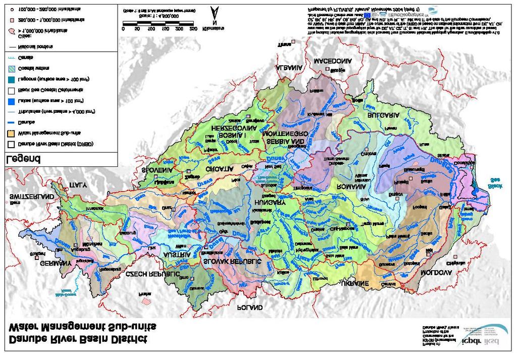
33 The GIS system will be further described in chapter 4.1. In the short term the objective of defining standards for GIS and the required layers and maps are the reporting obligations of the Member States (for details see summary of GD 9 in chapter 4.2). Twelve maps composed of 15 layers have to be reported to the Commission. They can be grouped in three categories: a) basic information and characteristics of the river basin district, b) monitoring network, c) status information of surface waters, groundwater bodies, and protected areas. The reporting scale for the short term is 1: In the long term 1: should be envisaged. In the long term, the development of specifications for a system including the possibility to access underlying measurements and statistical data (even performing analysis) as required for the preparation of the River Basin Management Plans might be considered (distributed system). The necessary elaboration of guidelines for these long-term options is subject to a request by the Strategic Co-ordination Group for the Implementation of the WFD Case Study: Implementation of the WFD in the Danube River Basin Introduction: To coordinate the Danube River Basin Management under the European Water Framework Directive is a large challenge, in view of the fact that the DRB is the most international river basin in the world covering 10% of Europe, territories of 18 countries, and having 81 million inhabitants. The International Commission for the Protection of the Danube in its 3rd Plenary Session in November 2000 assumed the task to coordinate the implementation of the WFD and the river basin management plan for the Danube River Basin. As you can see in the following graph, the ICPDR consists of various expert groups. Fig. 13 Organisational structure under the Danube River Protection Convention 32
34 The River Basin Management Expert Group coordinates the development of the Danube River Basin Management Plan which has to be submitted by All countries which ratified DRPC are represented. Outline of Danube RBM Plan 1. Characteristics of the river basin district (included in Roof Report 2004) 2. Significant pressures and impacts of human activity 3. Identification and mapping of protected areas 4. Monitoring networks and monitoring results (new chapters for RBM Plan) 5. Environmental objectives and exemptions (new chapters for RBM Plan) 6. Economic analysis of water use 7. Programme of measures (new chapters for RBM Plan) 8. Register of more detailed programmes and management plans (new chapters for RBM Plan) 9. Public information and consultation measures incl. results 10.List of competent authorities 11.Contact points for obtaining background documentation The Roof Report submitted in March 2005 already provided information on the River basin characteristics, impact of human activities and economic analysis required under Article 5, Annex II and Annex III, and the inventory of protected areas required under Article 6, Annex IV of the EU Water Framework Directive. The complete report consists of Part A: Basin-wide overview, and Part B: Detailed analysis of the Danube river basin countries. Four key water management issues for the DRBD were identified: 1. Organic pollution, 2. Nutrient pollution, 3. Pollution by hazardous substances, and 4.Hydromorphological alterations Relation international/national RBMPS Specific water management issues can be best achieved and managed on the international level, as it is the most efficient solution (ecological & economic efficiency). Information from the local/regional/national level has to be adequately translated to the international level to obtain basin wide solutions for: nutrient management flood management (control via hydropower dams, retention areas, etc.) longitudinal continuity (fish migration) alarm systems Criteria to define which aspects within each issue are of basin-wide importance have to be developed The following steps have been done in order to solve the significant water management issues: Several documents guide towards the RBMP: Strategic paper Road Map and Work Plan Issue Papers on key water management issues: organic, nutrient, hazardous substances, pollution, hydromorphological alterations 33
35 DATA AND INFORMATION MANAGEMENT IM & GIS Expert Group in coordination with RBM EG; Central data base for management of reported data (danubis) including a data base for chemical and biological data; Danube GIS for RBMP including GIS data and all other information (risk categories, status assessment, etc.); Interoperability Danube GIS/EU WISE of importance to better link/coordinate reporting obligations also on the international level are currently investigated (e.g. consequences for ICPDR) Working scale within DRB Plan Definition of Sub-Basin and Sub-Unit Sub-basin (according to Art. 2, 14. WFD) means the area of land from which all surface run-off flows through a series of streams, rivers and, possibly, lakes to a particular point in a water course (normally a lake or a river confluence). Sub-unit (defined for the use in the Danube River Basin District) means an area located on national territory consisting of a sub-basin, a part of a subbasin, a group of sub-basins, or a group of parts of sub-basins. Sub-basin approach: A: Danube river basin level B: Sub-basin level C: Sub-unit level -Sub-basin management plans National approach: A: Danube river basin level B: National level C: Sub-unit level-national management plans Roof Report 2005 Each EU Member State sent the Roof report (Part A) together with its own national report (Part B) to the European Commission. In addition, the ICPDR sent to the European Commission a copy of the Roof report and a copy of the national reports (Part B) of those countries, which at that time were not obligated to report to the European Commission (Bosnia and Herzegovina, Bulgaria, Croatia, Moldova, Romania, Serbia and Montenegro, and Ukraine). This approach was also undertaken for the delivery of information required according to Article 3 (8) and Annex I of the WFD. 34
36 35
37 4. Major Instruments used for the WFD implementation T he Common Implementation Strategy (CIS) supports the implementation of the WFD. It comprises the following elements: Activities on information sharing and raising awareness; Establishing an information management system; Developing guidance documents; Integrated testing in pilot river basins. For the implementation process the EU commission established working groups consisting of leading experts and stakeholders from various Member States. Each working group is led by a specific country. The first CIS working group strategy differentiated the following areas: 1.1 Tools for sharing information 1.2 Raising awareness 1 Sharing Information 4 Application, Testing and Validation Implementation Strategy 2.1 Analyse pressures and impacts 2.2 Heavily modified water bodies 2.3 Conditions of inland surface waters 2.4 Typology, classification of transitional, and coastal waters 2.5 Intercalibration 2 Develop Guidance 2.7 Monitoring 2.8 Tools on assesment and classification of groundwater 4.1 Integrated testing in pilot river basins 2.6 Economic analysis 2.9 Best practices in river basin planning 3.1 Geographical Information Systems 3 Info Management Fig. 14: Initial structure of CIS working groups These working groups developed the first guidance documents (1-11) for the implementation of the WFD. After revision of the CIS approach in 2003 a new organization of working groups was proposed since the number of working groups was considered to be too high, prohibiting integration of related areas or even leading to the duplication of work (CIS 2003). For 2004/2005 the organisational structure was modified, the result can be seen in Fig
, Article 14 promotes the active participation of all interested parties on the development of River Basin Management Plans and requires the Member States to inform and consult the public.")
38 Fig. 15: Organisational structure of current CIS approach 4.1. Information sharing and management In addition to the reporting obligations of the Member States (refer to chapter 3.6.2), Article 14 promotes the active participation of all interested parties on the development of River Basin Management Plans and requires the Member States to inform and consult the public. The latter can most efficiently be done by using maps, GIS technology and web mapping. Furthermore, the WFD emphasis in different parts on a common information system, which can be termed Geographical Information System (GIS), since most of the data or provided information from processed data, has a spatial extension. This system is referred to as WISE (Shared Water Information System for Europe) 3, which will be developed in the frame of the WFD and implemented by GD 9 on Implementing the Geographical Information System Elements (GIS) of the WFD distinguishes between two approaches: the short term and the long term technical approach. The short term approach has its focus on the reporting obligations of the Member States and leads towards a centralised information system, where the Member States deliver their GIS data and other information to the Commission. There, data will be stored, quality checked and analysed. The long term option is to leave all data at the place of origin (distributed system) and to guarantee access to these data to common standards and protocols. While the first is easier and therefore faster to implement, the second will reduce the burden of transferring data. Independent of the future system, the Commission emphasises on the necessity to develop the common system in line with existing and planned European systems. In this context, it is important to mention the INSPIRE (Infrastructure for Spatial Information in Europe) initiative. For data harmonisation this system should be adopted. It is important that the system can be linked to national systems via a common coding approach. Another good example for a database could be EuroGlobalMap at a scale of 1: compare also: Reporting for Water Concept Document: Towards a shared water information system for Europe (WISE) [Rom/Brussels, November 2003])
39 The WISE GIS is currently under development, notes from meetings with GIS experts from whole Europe in 2004 and 2005 are underlining the common development, led by the EU institutions (ENV, JRC, ESTAT, EEA), in close cooperation with the Member State Experts (GIS workshop, Brussels 2004). Further details on data accuracy, data validation, reference system, metadata, etc. are explained in GD 9. An interesting example for sharing information, documents and participate in discussion fora is the extranet tool CIRCA, developed under the European Commission IDA programme and tuned towards public administration needs. It is an internet working platform 5, which can also be adapted to other needs. The WDF Newsletter (first edition in 2003) turned the name into the WISE Newsletter in 2005 and can be seen as an information base for the newest updates of the WDF. They can be downloaded on the WDF CIRCA database Guidance Documents The Guidance Documents are intended to provide support for the implementation of the WFD to all Member States. They are considered living documents that will need continuous input and improvements as application and experience build up in all countries of the European Union and beyond Overview No. Name Link on CD --- Best practices: Identification of River Basin Districts..\Guidance Documents\Best practices in RBMP.pdf 1 Economics and the Environment..\Guidance Documents\Guidance No 1 - Economics - WATECO (WG 2.6).pdf..\Guidance Documents\guidanceEconomic_Annexes.pdf 2 Identification of water bodies..\guidance Documents\Guidance No 2 - Identification of water bodies.pdf 3 Analysis of pressures and impacts..\guidance Documents\Guidance No 3 - pressures and impacts - IMPRESS (WG 2.1).pdf 4 Identification and designation of heavily modified water bodies..\guidance Documents\GD 04 - HMWB - Policy Summary.pdf 5 Transitional and coastal waters..\guidance Documents\Guidance No 5 - characterisation of coastal waters - COAST (WG 2.4).pdf 6 Towards a guidance on the intercalibration network and the process on the intercalibration exercise..\guidance Documents\Guidance No 6 - intercalibration (WG 2.5)-1.pdf 7 Monitoring under the WFD..\Guidance Documents\Guidance No 7 - Monitoring (WG 2.7).pdf 8 Public participation in relation to the WFD 9 Implementing the Geographical Information System (GIS) elements of the WFD 10 Rivers and Lakes typology, reference conditions and classification systems..\guidance Documents\Guidance No 8 - Public participation (WG 2.9).pdf..\Guidance Documents\Guidance No 9 - GIS (WG 3.1).pdf..\Guidance Documents\Guidance No 10 - references conditions inland waters - REFCOND (WG 2.3).pdf 11 Planning process..\guidance Documents\Guidance No 11 - Planning Process (WG 2.9).pdf 12 The role of wetlands in the WFD..\Guidance Documents\Guidance No 12 - Wetlands (WG B).pdf 13 Overall approach to the classification of ecological status and ecological potential 14 Guidance on the intercalibration process Please note that there will be issued further guidance documents on specific issues!..\guidance Documents\Guidance No 13 - Classification of Ecological Status (WG A).pdf..\Guidance Documents\Guidance No 14 - Intercalibration process.pdf
40 Summaries of the Guidance Documents Best Practices in River Basin Management Planning Work Package 1: Identification of River Districts in Member States, Overview, criteria and current state of play Focus The document focuses on the definition of River Basin Districts (RBDs), assignment of groundwater shared by different RBD, definition of international and cross-border RBD and identification of competent authorities in water management and planning. Since most EU Member States had more or less completed the identification of RBD when this paper was released, this document was prepared mainly as a reference on the issue, as a guidance to finalise the process in remaining cases or to provide criteria for assigning coastal waters and groundwater to RBD. Relation to implementation of the WFD The identification of RBD is an important issue related to the development of river basin management plans in the WFD. It was the first tasks of the Member States which they had to report on. Concerning international river basin districts the Member States had to provide the Commission with a list of their competent authorities of all the international bodies in which they participate by June 2004 (Articles 3(8) and (9)). WFD Articles and Annexes of main relevance Basic requirements for the identification of river basin districts are mainly set in Article 2, 3 and 24 of the WFD. Regarding the functions of the competent authorities that have to be identified, Article 13 (planning and implementing), Article 8 (monitoring), Article 14 (public participation), and Article 15 (reporting) are of main importance. Structure and key elements In Section 1 the main definitions of the elements important for the identification of RBD are given. RBDs are defined as the area of land and sea, made up of one or more neighbouring river basins together with their associated groundwater and coastal waters, which is defined under article 3(1) as the main unit for management of river basins. Since the identification of river basin districts is expected to involve a number of political issues (especially the international districts), the designation of the RBDs is likely to require considerable flexibility. Regarding the size of a RBD, it is worth to consider combining or joining of RBD in case they are small. The criteria on which this combination could be based on are described as follows: climatic, environmental, socio-economic and administrative aspects. The principle of natural unity of the hydrological cycle and integrated water management do apply for this approach. Article 3.1 states that a groundwater body that does not fully follow a particular river basin, shall be identified and assigned to the nearest or most appropriate RBD. This means that shared groundwater must be assigned only to one RBD in contrast to coastal waters that could be assigned to one or several districts. Identification, characterisation and description of relevant shared groundwater are steps prior to the assignment to a RBD. 39

, Article 3(3) WFD regulates that each Member State shall ensure appropriate administrative arrangements of the application")
 coastal waters are defined as surface water on the landward side of a line, every point of which is at a distance of one nautical mile on the seaward side from the nearest point of")
41 Paragraph lists different criteria which can be used to assign shared groundwater to on RBD: Environmental aspects, as the existence of ecosystems dependent on water (e.g. wetlands) and connected to aquifers Pressures and impacts in each portion of aquifer Recharge and discharge areas Surface area of the aquifer in each portion of RBDs Fig. 16: Example of groundwater flows between two RBDs [source: paper on best practices in River Basin Management Planning] In case difficulties arises to assign a shared groundwater to only one RBD, the management of shared aquifers could be carried out in its respective portion of territory by the different RBD authorities. Then appropriate co-ordination must be ensured. Regarding shared groundwater in an International River Basin District (IRBD), Article 3(3) WFD regulates that each Member State shall ensure appropriate administrative arrangements of the application of the rules of the WFD within the portion of any international RBD lying within its territory. This applies to groundwater located within those RBDs as well. In Article 2 (WFD) coastal waters are defined as surface water on the landward side of a line, every point of which is at a distance of one nautical mile on the seaward side from the nearest point of the baseline from which the breadth of territorial waters is measured, extending where appropriate up to the outer limit of transitional waters. This concept requires a previous definition of a baseline, which encountered difficulties in some countries. The baseline defined in Spain for example cover only non-convex coastal stretches (defined by geo-referenced points that fit to geographic points (capes, islands, etc.), see figure below. Fig. 17: left: Baseline on Majorca Island, right: Baseline on the Catalan coast [source: paper on best practices in River Basin Management Planning] 40

42 Different results of defining the baseline can also appear because of tide. The United Nations Conventions on the Law of the Seas defines the normal baseline for measuring the breadth of the territorial sea as the low-water line along the coast. As mentioned already above also coastal water like all other water categories must be assigned to a RBD. This may involve the splitting of a stretch of coastal water, instead of being a single water body. Coastal water should be assigned to the closest natural management unit possible and any unnecessary splitting should be minimised. Paragraph comments on different possibilities on splitting the coastal water, it can be even assigned to more than on RBD. Most countries consider a reasonable approach the simple geometrical assignment. Fig. 18: Example of an assignment of coastal water streaches to RBDs [source: paper on best practices in River Basin Management Planning] In section 4.3 the designation of IRBD is summarised. Main issues are that each Member States shall ensure the appropriate administrative arrangements, including the identification of the appropriate administrative competent authority (Article 3(3)). Furthermore, the assignments of groundwater and coastal waters to the national portions remain as a rule the responsibility of the Member States (Article 3(1)). At the same time, all the Member States have together to ensure the necessary co-ordination for the whole RBD (Article 4(3)). The main IRBD are listed and the cases of the Danube and Rhine River Basins are described a bit more detailed. The next paragraph contains the main transboundary agreements. Section 4.4 describes in more detail the designation of competent authorities and their key functions. The institutional arrangements of the different Member States which were in place in 2002 based on responses to a questionnaire are summarised thereafter. Section 5 finally gives an overview of the state of identifying RBD of the Member States and Norway in 2002, when the paper was released. 41
43 Guidance Document No.1, Economics and the Environment Focus Guidance Document No.1 focuses on the implementation of economic elements in the broader context of the development of integrated River Basin Management Plans as required by the Water Framework Directive (WFD). Guidance document No.1 provides detailed information respective planning, methodologies for undertaking and reporting the economic analysis to the European Commission. The guidance document is divided into four essential parts: A) The role of economics in the Water Framework Directive (Section 2, Annexes B1, B2) B) Planning the economic analysis (Section 4, 5, Annexes A1, A2, C) C) Methodologies for undertaking the economic analysis (Section 3, Annexes A1, D1, D2a, D3) D) Reporting the results of the economic analysis (Sections 4,5, Annex C) References to WFD Articles, Annexes and Other Guidance Documents Explicit economic functions of the WFD: Art. 5, Annex III, Art. 9 Implicit economic functions of the WFD (non exhaustive): Art. 6, Annex III, Art. 4.3, Art. 4.4, Art. 4.5, Art For exhaustive list see Guidance Document No.1, Annex B. Further literature to economic analysis: Interviews, E.; Kraemer R.A. et al. (2004): Basic principles for selecting the most costeffective combinations of measures for inclusion in the programme of measures as described in Article 11 of the Water Framework Directive - Handbook Relation to Implementation of the WFD A) The role of economics in the Water Framework Directive (Section 2, Annexes B1, B2 of Guidance Document No.1) To ensure high environmental objectives with limited financial resources, the WFD requires the applications of economic principles (e.g. polluter pays principle), economic approaches (e.g. cost-effectiveness-analysis), and the consideration of economic instruments (e.g. water pricing). Main tasks of the economic analysis are to inform and to help decision makers in implementing the WFD. The economic analysis does not take any decisions itself. Functions of the economic analysis are divided into explicit and implicit functions. The term explicit refers to the economic elements that are specifically outlined in Art. 5 and Annex III. The term implicit refers to references made to economic issues in other parts of the WFD that require economic analysis not mentioned in Art. 5 and Annex III. Two figures show different explicit and implicit functions of the economic analysis (compare chapter 3.4, figures 10 and 11). As figured below the economic analysis conducted by 2004 should prepare the cost-effectiveness analysis in order to lay down the Programme of Measures (Art. 11, Annex 42
44 VII) and as a consequence to implement River Basin Management Plans (Art. 13, Annex VII). Technical Support of General Relevance B) Planning the economic analysis (Section 4, 5, Annexes A1, A2, B3, C) The economic analysis as part of the characterisation of river basins had to be carried out until the end of The economic analysis until 2004 includes the description of water uses and their economic relevance the determination of actual cost-recovery levels of water services a prognosis about the development of water supply and water demand until the end of 2015 ( baseline scenario ) the development of criteria to evaluate cost-effectiveness of measures (BMU 2005a). For further information on the evaluation of cost-effectiveness of measures see Interviews, Guidance Document No.1 in section 4, pp provides approaches to assess these elements of the economic analysis. Three elements are considered to be essential for undertaking the economic analysis: 1. Information and knowledge (Section 4, p. 32 and Section 5, pp ) Which information is available by now? Which additional information is needed? The guidance gives general advice for enhancing the information and knowledge base such as systematic reports on information, assumptions and approaches (p. 32). It stresses the fact that there is still much work left in developing methods for assessing water-related environmental costs, the direct economic impact of measures in key sectors (industry, agriculture, private) and for assessing the effectiveness of measures. 2. Capacity building (Section 5, pp and pp.43-44, Annex C2) Who needs to get involved in carrying out and using the economic analysis? Table 4, p. 37 of the guidance gives a useful overview on key stakeholders and where they can help with information and expertise. Annex C2 shows how to organise a stakeholder analysis. How should the economic analysis be integrated with analyses from other disciplines and expertise and at which stages of the WFD implementation process? Table 5, p. 39 of the guidance is helpful in defining key inputs from other disciplines and at which stage of the three-step approach. The guidance recommends strongly a linkage between different guidance documents of different working groups. Which financial and human resources are required and available for undertaking the economic analysis? With limited financial and human resources it is recommendable to develop priorities with other experts, stakeholders and organisations, who are involved in the development of River Basin Management Plans. 3. Integration with the decision making process (Section 5, p. 35) Which output and indicators should be produced by the analysis for taking decisions and reporting? Table 6, p. 44 shows concrete WFD reporting obligations respective the economic analysis and its required outputs. Before starting the economic analysis, two actions are recommended by the guidance document: 1. A feasibility study (Section 5, p. 45, Annex C): It aims at assessing whether the proposed economic approach can be made operational, if it is consistent with other activities of the implementation process and which key steps need to be followed to bring the economic analysis on its way. 43
45 2. A critical pathway analysis (Section 6, p ): Main objective of this analysis is to make sure, that Member States and candidate countries meet the Water Framework Directive's deadlines. The critical pathway analysis informs about time required for the economics assessment activities, time required for the consultation process, directive requirements, internal deadlines necessary for timing economic activities, considerations for policy makers, phasing in and refinement of economics assessment activities and about requirements of cooperation with other disciplines (for definition of heavily modified water bodies and the IMPRESS analysis). C. Methodologies for undertaking the economic analysis (Section 3, Annexes A1, D1, D2a, D3) Guidance Document No. 1 provides methodological help and approaches on: the economic analysis of water uses the economic assessment of potential measures for reaching good water status the assessment of the recovery of the costs of water services To implement the Directive's economic analysis Guidance Document No. 1 proposes a threestep approach. The different steps are specified in terms of objective, process, methodological scope, references in Guidance Document No.1, links with other tasks and likely information requirements. Fig. 19 shows a detailed overview of the three-step approach with objectives of the economic analysis, timing and links to other implementation activities of the WFD ( A Bird's View to the Three-Step Approach ). Notify that in this approach loops exist both within a single step as well as after having completed the third step due to future management cycles after 2015 required by the WFD. Main objectives of each step are: Step 1: Characterising the river basin (Section 3, pp , Annexes D1, E, B3) Step 1 aims at characterising a river basin respective its economics of water uses, trends in water supply and demand and current levels of cost-recovery of water services. Step 2: Identifying significant water management issues (Section 3, pp , Annexes D1, E) Step 2 aims at identifying water bodies who do not achieve environmental objectives according Art. 4 WFD. It helps to assess risks or gaps of failure in not achieving objectives. Step 3: Identifying measures and economic impact (Section 3, pp , Annex D1) Step 3 supports the development of the Programme of Measures to be integrated in river basin management plans (RBMP) through cost-effectiveness analysis. It aids at justifying possible derogation from an economic point of view (time and objective). Most important methodological guidance for implementing the three-step approach gives Annex D1. It contains a series of information sheets and is structured as followed: Scale issues : Helps to define geographical level of economic analysis and how to report results Estimating costs and benefits : Helps to understand how to estimate costs and benefits, which are defined as avoided costs. Reporting on cost-recovery : Helps to understand what and how to report on recovery of costs of water services. Baseline scenario: Helps to develop one or several alternative baseline scenarios Cost-effectiveness analysis: Helps to carry out a cost-effectiveness analysis of potential measures integrated in the programme of measures until Pricing as an economic instrument: Helps to assess the effectiveness of pricing as demanded in Art. 9 WFD. Disproportionate costs: Helps to assess whether costs of Programme of Measures are disproportionate and whether derogation from the Directive's objectives could be justified. 44

46 Fig. 19: A Bird s View to the Three-Step Approach Guidance Document No.1, p.17 D. Reporting the results of the economic analysis (Sections 4, 5 and Annex C) In section 4, pp the guidance provides a summary of carrying out and reporting the economic analysis. Reporting obligations, respective the economic analysis, have to be linked with existing or pending regional or national reporting obligations. The obligatory question during the whole process of the economic analysis is Which output and indicators should be produced by the economic analysis for taking decisions and reporting? Table 6, p. 44 summarizes WFD reporting obligations with regards to the economic analysis. For each component of the economic analysis it names reporting requirements defined in the WFD and possible interests from water managers, policy makes, stakeholders and the public. Guidance for possible report protocols gives Annex C. It contains suggestions for reporting tables about the economic analysis of water uses, the assessment of trends and the baseline scenario, the assessment of levels of cost-recovery for each water service, about basic economic information and indicators and an example of an executive summary of economic elements of the characterisation of a river basin 45
47 Guidance Document No 2, Identification of water bodies Focus The Guidance Document focuses on giving specific partial suggestions for the identification of water bodies. Surface water bodies or bodies of groundwater may each be grouped: a) For assessing the risk of failing to achieve the objectives set for them in Article 4 [pressures and impacts] (refer to WFD CIS Guidance Document No.3). b) For monitoring, reporting and management purposes (refer to WFD CIS Guidance Document No.7). Relation to the implementation of WFD The success of the directive will be mainly measured by the status of water bodies [Article 2 (13), (15), (10), and (12) respectively]. Water bodies will be therefore the unit that will be used for reporting and assessing compliance with the Directive s principal environmental objectives. Hence the identification of water bodies is a tool not an objective itself. Therefore this identification is a starting point for all member states. Nevertheless it s an iterative and on-going process. The first step had to be finished by the 22 of December 2004 and reported to the commission three month later [Article 15.2]. WFD Articles of main relevance Article 5 (analyses and reviews) and Article 8 (monitoring programmes) will give information to update and improve the identification of water bodies after the first completion (22 December 2004). If necessary, this review of water bodies can continue until 22 December 2013 and then every six years. Article 4.3 is important for the identification of heavily modified water bodies. In the context of identifying bodies of groundwater Article 7 has to be mentioned. Here the min. abstraction rate for the definition of groundwater bodies is defined. Structure and key elements The main issues of GD2 are: Specific guidance for the identification of surface water bodies - Discrete and significant elements - Status criteria and protected areas - Practical applications Specific guidance for the identification of bodies of groundwater - Aquifers (significant flow, significant quantity - Delineation and boundaries - Targeting measures The key tasks can be divided into two main sections: Identifying surface water bodies and bodies of groundwater. It describes principles as well as a hierarchical process for sub-dividing river basin districts into water bodies. Generally it can be stated that the identification is, first and foremost, based on geographical and hydrological determinants. At the same time the size of the water body has to be identified. Here it is important that they permit an accurate description of the status of aquatic ecosystems and avoid an increase of administrative burden (in case of endless sub-division of water bodies). 46

48 Guidance on bodies of surface water Article 2.10 gives the following definition: Body of surface water means a discrete and significant element of surface water such as a lake, a reservoir a stream, river or canal, transitional water or a stretch of coastal water. Each water body should be identified on the basis of its discreteness and significance in the context of the Directive s purposes, objectives and provisions. 1. Categories of surface water [source: WDF CIS Guidance document no.2, Fig.2, p.6] 2. Physical features, here river confluence [source: WDF CIS Guidance document no.2, Fig.3, p.7] 3. Designation of heavily modified water bodies [source: WDF CIS Guidance document no.2, Fig.5, p.8] 4. Water bodies according to different status [source: WDF CIS Guidance document no.2, Fig. 4, p.7] Fig. 20: Identification of water bodies Summarized the following attributes must be considered (see also the above figures): a surface water body must not overlap with each other, it must not been split between different surface water categories (river, lakes, transitional waters and costal waters [Article ], should not cross the boundaries between surface water body types, geographical or hydromorphological features should be considered, heavily modified and artificial water bodies must be provisionally identified during the characterisation of surface waters. 47

49 Beside this, the GD 2 describes two more criteria for the delineation of surface water bodies: 1. Status criteria and 2. Protected areas 1. A water body must be capable of being assigned to a single ecological status class. 2. Existing boundaries of protected areas may be considered for the identification of water bodies under the WFD. Fig. 21: Summary of suggested hierarchical approach for the identification of surface water bodies Guidance on bodies of Groundwater Definition [Article 2.12]: Body of groundwater means a distinct volume of groundwater within an aquifer or aquifers. Aquifer [Article 2.11]: Aquifers mean a subsurface layer or layers of rock or geological strata of sufficient porosity and permeability to allow either a significant flow of groundwater or the abstraction of significant quantities of groundwater. The following figure summarizes the directives definition of aquifers: Source GD 2 Fig. 22: Definition of aquifers The directive s definition of aquifers requires two criteria to be considered in determining whether geological strata qualify as aquifer. In practice the criteria mean that nearly all groundwater in the Community would be expected to be within aquifers [source: GD 2, Fig.9, p.16] 48


50 The delineation of groundwater bodies It must ensure that the relevant objectives of the Directive can be achieved. It should be delineated in a war that enables an appropriate description of the quantitative and chemical status of groundwater. Nevertheless the following criteria may help for the first identification: Geological boundaries Other hydraulic boundaries (e.g. groundwater flow lines), see figure below Differences in status: here initially the member states might now have sufficient information to accurately define the status of groundwater. It may be appropriate to use the analysis of pressures and impacts [Article 5 and Annex II(2)] as an indicator of status Fig. 23: Subdivision of aquifers Sub-devision of aquifers into bodies of groundwater using hydraulic boundaries (Need for subdivision: 1. change in groundwater status, 2. by geological of hydraulic boundaries to facilitate classification of quantitative status. [source: GD.2, Fig.10, p.18] The following figure summarizes the process for identifying bodies of groundwater: [source: WDF CIS Guidance document no.2] Fig. 24: Summary of the suggested hierarchical approach to the identification of bodies of groundwater 49

51 Guidance Document No 3, Analysis of Pressures and Impacts Focus This guide for an environmental risk assessment explains the role of the pressures and impact analyses in the WFD, its implementation and how the results can be used in the River Basin Management Planning process and when elaborating the Programme of Measures. Article 5 of the WFD requires a review on the impacts of human activities on the status of surface waters and groundwater which had to be completed until They will then be reviewed by 2013, and subsequently every 6 years. Annex V shows an overview of many case studies of European watersheds analysed through the DPSIR framework. The Guidance does not focus on how to designate heavily modified water bodies (WFD CIS Guidance Document No 4) or on how to design monitoring programmes (WFD CIS Guidance Document No 7 on Monitoring). Section 2 illustrates how the DPSIR analysis contributes to the characterisation of water bodies in general and refers to WDF Article 5, which requires that for each river basin district 1. an analysis of its characteristics, 2. a review of the impact of human activity on the status of surface waters and groundwater and 3. an economic analysis of water use has to be elaborated. The following table shows the general approach of the DPSIR analysis: Table 3: The DPSIR framework as used in the pressures and impact analysis [source: GD 3, table 2.2, p.13] Section 2.1 focuses on the integration of the DPSIR analysis with the economic analysis and refers to WFD CIS Guidance Document No 1. The review of surface and groundwater bodies is stipulated in Annex II of the WFD. A specification for the impact review is contained in WFD Annex II Section 1 for surface waters and Annex II Section 2 for groundwater. 50
![[source: GD 3, figure 2.1, p.10] Fig.](/docs-images/96/127252156/images/52-0.jpg "25: Requirements for impact analysis for surface and ground waters,")

52 [source: GD 3, figure 2.1, p.10] Fig. 25: Requirements for impact analysis for surface and ground waters, specified by the WFD [source: WDF CIS Guidance document no.3, figure 2.3, p.14] Fig. 26: Illustration of the DPSIR analytical framework, note: the response is not considered in this guidance 51
53 Surface waters review: 1. Characterisation of surface water body types 2. Ecoregions and surface water body types 3. Establishment of type-specific reference conditions for surface water body types 4. Identification of Pressures 5. Assessment of Impacts GD 3 only addresses the final two parts of this process and indicates a broad categorisation of the pressures into: Point sources of pollution Diffuse sources of pollution Effects of modifying the flow regime through abstraction or regulation Morphological alterations Any other pressures, i.e. those not falling within these categories, must also be identified. In addition there is a requirement to consider land use patterns (e.g. urban, industrial, agricultural, forestry etc) as these may be useful to indicate areas in which specific pressures are located. Groundwater review: 1. Initial characterisation, including identification of pressures and risk of failing to achieve objectives; 2. Further characterisation for at risk groundwater bodies; 3. Review of the impact of human activity on groundwaters for transboundary and at risk groundwater bodies; 4. Review of the impact of changes in groundwater levels for groundwater bodies for which lower objectives are to be set according to Article 4.5; 5. Review of the impact of pollution on groundwater quality for which lower objectives are to be set. The DPSIR addresses all parts of this process. The pressures identified in WFD Annex II, Subsection 2.1 correspond to the first three of the categories identified for surface waters, namely: Point sources of pollution Diffuse sources of pollution Changes in water levels and flow caused by abstraction or recharge In section 2.3, the definition of water bodies in reference to GD 2 is explained and spatial and temporal scaling issues for the analysis are illustrated. Further in the section, the objectives for surface water (the biological, chemical and physical and hydromorphological and ecological status), groundwater (quantitative and chemical status) and protected areas. Wetlands are not especially mentioned in the WFD and therefore can not yet be included in the IMPRESS analysis. Section 2.4 summarizes the key components of the DPISR assessment. Key components in a four-step process: 1. describing the driving forces, especially land use, urban development, industry and agriculture 2. identifying pressures with possible impacts on the water body and on water uses 3. assessing the impacts resulting from the pressure 4. evaluating the likelihood of failing to meet the objective. Section 3 concretes the approaches that can be taken according to water body type and data availability. The key stages of the general approach as laid down in the WFD are describes: identifying driving forces and pressures, identifying the significant pressures, assessing the impacts and evaluating the likelihood of failing to meet the objectives. Section 3.1 deals with the stakeholders, institutions and individuals who need to get involved in carrying out and using the pressures and impacts analysis to provide input into the IMPRESS analysis or using the results. 52

54 Sections 3.2 to 3.6 describe the key components in the analysis of pressures and impacts as already shown in chapter 3.2.4, Fig.7. The description of a water body and its catchment area will underpin the pressures and impacts analysis, especially information on climate, geology, soil and land use might be very useful. Section 3.2 explains that driving forces that may be exerting pressures on the water body have to be identified. In section 3.3., examples of pollution pressures on surface and ground water from diffuse and point sources are presented in different tables. Furthermore quantitative resource pressures on ground water and surface water as well as hydromorphological pressures on surface waters and biological pressures are listed. The latter ones can have a direct impact on living resources, either quantitatively or qualitatively. At the end of the paragraph methods for the assessment and variations of pressures and impacts are pointed out. Section 3.4 deals with the assessment of the impacts on a water body depending on quantitative information on the state of the water body and on the pressures acting on it as well as on the available data. Possible impacts and changes in the state can be seen in chapter 3.2.4, Table 1 and 2. Furthermore, modelling approaches and the use of the different data types are illustrated. Section 3.5 illustrates the role of selecting relevant pollutants on river basin level within the concept of the good ecological status and good chemical status of the WFD (compare Fehler! Verweisquelle konnte nicht gefunden werden. 27). Priority substances are clearly identified in Annex X. One key question in the context of the analysis of pressures and impacts is the selection of specific pollutants (other than priority substances) for which data on pressures must be collected in order to assess whether there are impacts on water bodies. It provides a generic approach that may be used for the selection of a list of relevant specific pollutants (see Annex IV). Fig. 27: Needed steps to derive a selected list of pollutant [source: GD 3, figure 3.3 p.4] 53
55 Section 3.6 deals with the importance to evaluate the risk to fail the WFD objectives regarding the threshold values in Annex V and X of the WFD, section 3.7 with the conceptual model approach (here used as a synonym for understanding and does not mean numerical model). A conceptual understanding of the flow system, chemical and, in the case of surface water, also the ecological variations within a water body and the interaction between groundwater and surface ecosystems is essential for characterisation. Section 3.8 is about the use of similar, analogous water bodies, e.g. to adapt available data of a similar site and the assessment made from the observed data can be applied validly to both sites. The possibility of grouping water bodies for the purpose of pressure and impact analysis and monitoring is addressed in the WFD Guidance Document no. 2. In general this Guidance tries to apply similar considerations to surface and groundwaters. However, section 3.9 considers issues that are particular to groundwaters. In section 3.10, recommendations on reporting on the pressure and impact analysis are given, like required in WFD Article 15. Sections 3.11 and 3.12 provide reviews of the tasks required for the analysis for surface waters and groundwater respectively using the DPSIR framework. The tables on the key tasks for surface and groundwater may be regarded as checklists for the process. Section 4 focuses on the tools needed to assist the analysis of pressures and impacts as outlined in Chapter 3 and mentions some of those tools already available. A Pressure checklist can be found in section 4.2. The objective of the screening approach (further elaborated in section 4.3) within the general approach is to point out with simple assessments those water bodies that are clearly at risk or not at risk of failing to meet the objectives in Section 4.4 introduces the use of Numerical Models in ecological, hydrogeological and geochemical systems. Existing tools as well as the lack of some are presented in section 4.5. According to the IMPRESS analysis, either tools serve to quantify the pressure or they enable to assess the state. This identification is carried out for the main water body categories, i.e., rivers, lakes and ponds, groundwater and transitional waters and visualized in four matrixes, (one per water body category). Section 5 has the aim to indicate which type of information and data might be useful in the analysis of impacts and pressures, and gives a European-scale source for the information (in case of existence). It is recommended that, where possible, data is collected in digital form and used within a GIS. In section 6 examples of current practice relevant to the WFD pressures and impacts analysis are introduced. Annex V contains case studies presented by members of the IMPRESS working group as examples of current practice.these case studies can t serve as best practice examples yet. Section 7 concludes the guidance document looking out on further steps. In Annex I, the working groups of the Common Implementation Strategies are presented, Annex II provides a glossary, Annex III lists the contacts of the participants of the IMPRESS WG, Annex IV lists examples of tools according to Chapter 4 and in Annex V the case studies can be found. 54
 identification and designation.")
56 Guidance Document No 4, Identification and Designation of Heavily Modified and Artificial Water Bodies Focus The GD describes the step-by-step approach of the HMWB (Heavily modified water bodies) and AWB (artificial water bodies) identification and designation. It specifies the key regulations (Annex III) and characterizes the reference conditions and environmental objectives for these water bodies. Relation to implementation of the WFD Some water bodies can t or may not achieve the overall goal of the WFD to get a good ecological and chemical status in all water bodies by Under certain conditions the WFD permits Member States to identify and designate HMWB and AWB according to Article 4(3). Instead of good ecological status (GES), the environmental objective for those kind of water bodies is to achieve good ecological potential (GEP) by In 4 the timetable for the identification of water bodies and possibly of HMWB and AWB is illustrated. Table 4: Major WFD deadlines in the timetable for the identification and designation of HMWB and AWB in the first planning cycle [source: Figure 11, GD 4, page 67] All the achieved objectives (designation of HMWB and AWB, the definition of MEP, the identification of GEP as well as the programme of measures to achieve the relevant environmental objectives) will be published as part of the River Basin Management Plan by 2008 as first consultation drafts and 2009 as final plan. After that it will be revised every six years. After 2009 further review can also be undertaken for the second RBMP which has to be finished in the end of 2013 (see last paragraph of this summary). WFD Articles and Annexes of main relevance for GD 4 (as well related GDs) In Article 4(3) a test is specified, which may allow to achieve the objective of GEP instead of GES (in other words the definition for a HMWB). Article 4(4) allows for an extension of the deadline to achieve the environmental objective under certain conditions. Article 4(5) deals with derogations for all water bodies including those concerned with hydro morphological alterations. Article 2(9) gives a definition of a HMWB. Annex II contains the necessary provisions. Article 2(8) defines the AWB. Different working groups are mentioned in section 3.2 which are strongly linked to this GD: The working group 2.1 on Pressures and Impacts (IMPRESS) for example agreed on using, to use this guidance document on the characterisation process related to physical alterations of water bodies to develop an integrated approach to the entire characterisation process (incl. risk assessment). Here Annex II (Article 1.4 and 1.5) has to be me ntioned, especially for the conduction of step 3-5 of the approach in Table 4. The Intercalibration working group 2.5 (GD 55
57 6 and Annex V) should ensure that the sensitivity boundaries between the high/good and good/moderate borders are comparable across Europe. The reference conditions for the HMWB and AWB are determined by the nearest natural equivalent to the modified water body. Guidance on how to define reference conditions of assessing the ecological status of surface water bodies is being developed by the working group 2.3 (REFCOND), GD 10 and working group 2.4 (COAST), GD 5. The economic analysis working group 2.6 (WATECO) and HMWB have worked together to ensure that the guidance on the HMWB & AWB designation tests ensure consistent applications of economic terms across the WFD requirements. The monitoring working group 2.7 assist Member States in understanding the monitoring requirements for the identification of potential HMBW (GD 7). The links to the GIS working group 3.0 are related to the requirements to map the distribution of provisional identified HMBW and AWB (by 2004) and designated water bodies (in 2008/09). Also the mapping of the distribution of the relevant pressures which result in the designation of the HMBW and AWB may be helpful. Structure and key elements Section 3 gives an overview about the definitions of HMBW and AWB and the context to the WFD as well as to the other working groups. The definitions are given as follow: A heavily modified water body (HMWB) means a body of water which as a result of physical alterations by human activity is substantially changed in character as designated by the Member state in accordance with the provision of Annex II (Article 2(9)). Whereas Article 2(8) defines artificial water (AWB) body as a surface water created by human activity. It is a surface water body which has been created in a location where no water body existed before and which has not been created by the direct physical alteration or movement or realignment of an existing water body (paragraph 3.1.2). Once designated as HMWB or AWB, the environmental objectives are good ecological potential (GEP) and good chemical status, which also have to be achieved by These environmental objectives are set in relation to reference conditions (the maximum ecological potential, MEP). MEP is defined as the state where the biological status reflects, as far as possible, that of the closest comparable surface water body taking into account the modified characteristics of the water body. A stepwise approach for the designation of HMWB and AWB is given in Section 4. It is worth to mention the IMPRESS and HMWB working groups have recommended that the provisional identification of HMWB in 2004 will be carried out against the GES, to overcome the practical difficulties of defining the MEP and GEP at this early stage. The following figure illustrates the stepwise approach. Step 1 is applicable to all water bodies and involved the application of the GD 2 on water body identification. Detailed information about the different steps is given in GD 4. 56

58 Fig. 28: Steps of the HMWB & AWB identification and designation process [source: Figure1, GD no.4, page 20] As seen in the timetable, step 1 6 leads to the provisional identification of the HMWB and to the characterisation of the river basin district. This is further elaborated in Section 5. Here examples for AWB are given, significant changes in hydromorphology is defined, as well the likelihood of failing good ecological status. An overview of main specific uses, physical alterations and impacts is given to define if a water body substantial changed in character due to physical alterations by human activity (step 6). In case hydromorphological changes do not coincide with the boundaries of a surface water body, it may be appropriate to subdivide the water body in order to separate heavily modified stretches from the unaffected areas of the water body. Section 6 gives more details about the tests leading to the designations of HMWB (step 7 9 of Fehler! Verweisquelle konnte nicht gefunden werden.). It is important to mention the designation of HMWB and AWB is optional. Member states can choose not to designate a water body as an AWB or HMWB. The tests can be stopped at any point in the process. In this case the water body would be treated as a natural water body and the environmental quality objective would be GES. In article 4(3)(a) & (b) of the WFD are two designations tests described. In some cases both tests do not have to be carried our entirely (compare GD 4, Figure 6 for more detail). For AWB only the designation test 4(3)(b) applies. The tests are water body specific. In addition to the extensive description of the sub-steps, which lead to the designation of HMWB section 6 gives guidance on methods for applying the tests. It ranges from descriptive (qualitative) methods to more complex methods like in-depth economic assessment methods. The latter ones should only be used in case decisions cannot easily be made with the descriptive ones. The reference conditions and environmental objectives for HMWB and AWB (step 10 & 11) are specified in Section 7 in detail. During the establishment of appropriate values for the quality 57
59 elements at MEP it is important to differentiate between closest comparable surface water category and closest comparable surface water body type. The appropriate quality elements are chosen from the closest comparable categories, whereas closest comparable water body types are used to help determine the value of these elements for HMWB and AWB. The definition of MEP must ensure that the achievement of GEP is compatible with the achievement of the objectives established by other community legislation, such as Fauna Flora Habitat Directive (92/43/EEC) and the Birds Directive (79/409/EEC). At the same time, the requirements of the WFD need to be respected in the implementations of these directives. The establishment of the GEP is further elaborated through step 11. The GEP is defined as the state where there are slight changes in the values of the relevant biological quality elements as compared to the values found at MEP (Annex V No ). Regarding reporting and mapping for HMWB and AWB the ratio of the measured values of the biological parameters and the values for these parameters at MEP [ ecological quality ratio, Annex V, No.1.4] will be used in classifying the status. Member states must establish values of the environmental quality ratio that correspond to the boundaries between the status classes. For reporting purposes and mapping, MEP and GEP are combined in a single class [Annex V, No (ii)]. Finally Section 8 gives some insight of cross-cutting issues. One is the overview of measures and their costs in the HMWB and AWB process. Another is the hint to have a look at HMWB and AWB in future RBMP cycles. In this context is important to me ntion that the identification and designation of these water bodies is not a one off process and the Directive provides for the flexibility to modify designations taking into account the changes over time on environment, social and economic circumstances. The second RBMP cycle has to be finished by 2013 [Article 5(2)]. Here the characterisations of the water bodies will have been finished and a fully compliant monitoring program should be in place. The designation tests in the second cycle will be applied in three circumstances: i) suspected HMWB and AWB which were possibly, mistakenly not designed in the first RBMP; ii) newly modified water bodies; iii) as part of the review of existing HMWB and AWB. Also the MEP (and GEP) has to be reviewed every six years) [Annex II No. 1.3(ii)]. 58
60 Guidance Document No 5, Identification of water bodies Focus The CIS WG 2.4 (COAST group) focuses with this Guidance Document on the key requirements for the implementation of the Directive in relation to coastal and transitional waters. Relation to implementation of the WFD This document covers the water bodies of Typ B and has to be seen in relation to the definition of water bodies and RBD, as well as to the characterisation and evaluation of this water types. WFD Articles and Annexes of main relevance, as well as related GD Article 2(6) and 2(7) define the main terms. Annexes II and V of the WFD deal with transitional and coastal waters. The document: Identification of River Basin Districts in Member States, described as the first document in chapter 4 also refers to coastal water in the context of definition of RBD. Refer also to GD 2 and GD 4 for definition of water bodies. Article 3 (1) and Annex II 1.1 are important for the before mentioned definitions. Structure and key elements In section 2.1 some definitions are given. Transitional waters are defined as (Article 2(6)): bodies of surface water in the vicinity of river months which are partly saline in character as a result of their proximity to coastal water but which are substantially influenced by freshwater flows. Article 2(7) defines coastal waters as surface water on the landward side of a line, every point of which is at a distance of one nautical mile on the seaward side from the nearest point of the baseline from which the breadth of territorial waters is measured, extending where appropriate up to the outer limit of transitional water. One of the hydromorphological quality elements for both transitional and coastal waters is the structure of the intertidal zone. Section 2.2 gives guidance of defining surface water bodies within transitional and coastal waters. Surface water types as well as surface water categories and surface water bodies are further described. In section 2.3 transitional waters are defined in detail, including the seaward boundary. This might be defined through the European and National legislation, or if not through the salinity gradient, physiographic features or modelling. The freshwater boundary is defined by Annex II and where salinity is less than 0.5. Other methods are defined in and of the GD 5. Section 2.4 deals with the assignment of coastal waters within the RBD (refer to: Identification of River Basin Districts.see above). Section 2.5, 2.6 and 2.7 contain explanations about territorial waters, marine lagoons and wetlands. All this waters and ecosystems have to be considered when talking about the WFD. The Section 3: Guidance for Typology in Transitional and Coastal Waters interprets the requirements of the WFD to define typology as one of the supporting factors in determining ecological status. Annex II 1.1. (iv) states: If system B is used, Member States must achieve at least the same degree of differentiation as would be achieved using System A.. This is the reason why different factors for the further characterisation of System B (transitional and costal waters) have been developed. These factors can be divided into obligatory and optional factors (details see Annex II and 1.2.4). 59
61 The obligatory factors are: Latitude/Longitude Ecoregion (Annex 11 of WFD) Tidal Range Salinity The optional factors are: Transitional Water Mixing Intertidal Area Other factors until an ecologically relevant type of water body is achieved Residence Time Coastal Water Wave exposur Depth (not in AnnexII list) Other factors until an ecologically relevant type of water body is achieved In section 3.5 thresholds of the factors given above are listed and an explanation how the factors can be used for the characterisation is given. Section 4 gives guidance on the development of biological reference conditions for coastal and transitional waters. It explains the concepts of biological reference conditions and presents a way to use these concepts in practice. Reference conditions are a description of the biological quality elements of high status. In Annex V, table and gives definitions of the biological elements at high status in transitional and in coastal waters (see GD section 4.4). Section 4.5 shows some methods for determining reference conditions. Section 5: General guidance on the classification of ecological status within transitional and coastal waters, introduces the principle underlying classification and the requirements of classification tools and schemes for the purpose of the WFD. Refer also to chapter Status of water bodies in the main document. Details on classification of the different elements can be found in GD5, p Section 6 provides a toolbox which contains examples of existing classification schemes and tools for transitional and coastal waters that may be suitable for testing by Member States. Member States are encouraged to test existing classification schemes and tools in their ecoregion and share the results and knowledge gained with experts from other Member States. Examples are given from France, Sweden, Greece, Spain, Norwegian, UK (test of a South African Fish Classification System) and Belgium. They are referring to phytoplankton, other aquatic flora, littoral benthic communities, benthic invertebrate fauna and fish, but also hydromorphological and physio-chemical elements are considered. In Annex D a glossary of the terms in this GD is provided. 60

62 Guidance Document No 6, Intercalibration network and the process on the intercalibration exercise Focus Guidance document No. 6 aims at guiding experts and stakeholders in the procedure of establishment of the intercalibration network and in the intercalibration exercise of the WFD. In this context, the main goal is to ensure comparability of biological monitoring results between the member states. The document is produced by working group 2.5 (Intercalibration), which is composed of technical experts from governmental and nongovernmental organisations. WFD Articles of main relevance for GD 6 Article 21 Annex V Structure and key elements of GD 6 Fig. 29 shows the general structure of the guidance for the process of intercalibration. It is underlined that the overall approach for the selection of intercalibration sites and the intercalibration process described in GD 6 needs to be tailored for the different ecoregions and surface water categories, due to the diversity of surface waters in the EU. To achieve this, a procedure has been proposed involving experts from all member states. Fig. 29: Structure of the guidance for the process of intercalibration The document is structured in five sections and three annexes, briefly described as follows. Section 1: Implementing the Directive: Setting the scene Section 1 describes the overall context for the implementation of the WFD and points out the activities of WG 2.5 in the working process. A figure demonstrates the links between WG 2.5 and other working groups which have been integrated or consulted during the guidance development phase. There was a close cooperation particularly with the WG REFCOND. Section 2: Common understanding of the text and terms related to intercalibration requirements Section 2 refers to relevant parts of Annex V and Article 21 of the WFD and Decision 1999/468/EC. Relevant text passages dealing with the classification and presentation of ecological status are discussed to come to an agreement on their meaning in practical terms. Furthermore, some suggestions concerning the timetable of the intercalibration process are made. 61
63 Section 3: Synthesis of the intercalibration process: problems and possible solution In section 3 a synthesis of the intercalibration process is presented and the key steps of the critical path and the bottlenecks in the fulfilment of the requirements of the WFD are discussed. The section is divided into subsections 3.1 to 3.6. Section 3.1 is about the formal requirements and the timetable of intercalibration, section 3.2 refers to the obstacles in the timetable. Section 3.3 applies to the problem of typology incompatibility. Certain problems, such as the use of different typology systems in different member states or timing difficulties are discussed, and possible solutions are presented. Section 3.4 is dedicated to the problem of data availability. The main problems addressed are insufficient or incomplete data for the monitoring systems and the site collection for certain implementation steps of the WFD. Potential solutions on a short term basis are identified. A table (GD 6, table 2) shows the key steps and bottlenecks of the intercalibration process. The problems of limited intercalibration are discussed in section 3.5. The intercalibration sites are selected by the member states using information on pressures and the impact of these pressures on the biological quality elements. As long as there is either a general lack of monitoring data on biological quality elements or data are only available for widespread, common pressure, a good ecological status can not be verified for all surface waters. The essence of section 3.6 is that a long-term strategy to overcome the problems of intercalibration is strongly recommended. Section 4: Guidance for the establishment of the intercalibration network Section 4 provides a practical guidance for the establishment of the intercalibration network. It is explained how to: Carry out site selection process for the intercalibration network in practise; Establish criteria for selection of types for the intercalibration network; Establish criteria for selection of sites for the intercalibration network. Section 4.1 structures in detail the procedure for the establishment of the intercalibration network and explains how to carry out the site collection process in practice. It is said that the selection of intercalibration sited needs to be carried out in two steps, as shown in Fig. 30. Firstly, the water body type has to be selected for each surface water category in each ecoregion, and secondly, a minimum number of intercalibration sites within these types have to be selected by the member states following the requirements described in the WFD, Annex V. The proposed procedure includes the following 10 steps: 1. Establishment of the Expert groups; 2. Proposal of water body types; 3. Proposal of pressures and biological quality elements; 4. Selection of types, pressures, and quality elements for the intercalibration network; 5. Selection of sites for the draft intercalibration register; 6. Metadata analysis; 7. Evaluation of the proposed intercalibration sites by expert groups; 8. Finalisation of the draft register; 9. Presentation of the draft register to the Article 21 Committee; 10. Revision of the draft intercalibration register. 62
 as well as the most")
64 Fig. 30: Selection of intercalibration sites for the intercalibration network. Section 4.2, Criteria for the selection of water body types for the intercalibration network, defines certain points which should be considered in the selection of typology system(s) as well as the most important requirements for the selected intercalibration types. The latter are shown in the box below (according to: GD 6, page 32). Most important requirements for the selected intercalibration types: Are common (found in at least 2 or more member states, and covering sufficiently large geographical areas (or ecoregions) to enable comparison of different (national) assessment systems, and all ecoregions should be covered); Are sensitive to and impacted by different pressures (e.g., organic pollution, physical alterations, acidification, eutrophication; habitat degradation, discharge or exposure to toxic substances); Allow Member States to identify reference conditions at the time of the site selection; Should have potential intercalibration sites corresponding to the boundary between high/good and good/moderate available, but accepting that in some ecoregions/types there might be only sites representative for the moderate/ good boundary. Section 4.3 is dedicated to artificial and heavily modified water bodies. The main conclusion of this chapter is that artificial and heavily modified water bodies can only be included in the intercalibration network, if they fulfil the same selection criteria as natural water bodies. This needs to be proved by expert groups during the selection process. Section 4.4 gives useful suggestions how to deal with pressures. Due to different ecological impacts of different pressures and the use of different indicators for the impact assessment, the intercalibration exercise has to analyse each pressure separately. Therefore, it should be agreed which pressure to focus on for each selected intercalibration type. The practical suggestion of WG 2.5 is to focus on the pressures that are most widespread in Europe: 63
65 Lakes: Eutrophication, acidification Rivers: Organic pollution, stream modification, acidification and nutrient pollution (for both: selected types only) Coastal and transitional waters: Eutrophication, habitat degradation The intercalibration network must be confined to ecoregions. Therefore, geographical intercalibration groups are defined in section 4.5. Preliminary proposals are: Rivers: Three groups: Northern, Middle latitude, Mediterranean; Lakes: Five groups: Northern, Atlantic, Central, Alpine, Mediterranean; Coastal and transitional waters: It is recommended to use the ecoregions of System A: Baltic, North Sea, Northeast Atlantic, and Mediterranean. Section 4.6 deals with specific aspects of the selection of intercalibration sites, and section 4.7 applies to the number of intercalibration sites needed. Concerning the first aspects, a ranking of water bodies across a range of quantified pressure criteria in order to identify sites that are provisionally representative for the high-good and the good-moderate class boundaries could be a helpful tool. Regarding the second point, it is recommended that the draft intercalibration register should contain at least five sites at each of the quality status boundaries for each water body type and for each geographical intercalibration group. A few aspects concerning the metadatabase for the establishment of the intercalibration network are mentioned in section 4.8. The purpose of this database is to provide consistent information and allow a maximum transparency. Section 5: Preliminary technical protocol for the intercalibration exercise Section 5 contains specific practical guidance for the intercalibration exercise in 2005 and The preliminary description is not completed; further guidance is given in GD 14. Annexes Annex A describes the key activities and the working groups of the common implementation strategy, in Annex B the members of WG 2.5 are listed, and finally, Annex C contains the legal texts related to the committee procedure. 64
66 Guidance Document No 7, Monitoring under the WFD Focus The main objective of the WFD is to obtain good status in all water bodies. Monitoring provides the necessary data to determine the status. Based on monitoring data the impacts of pressures can be quantified and the success of the programme of measures can be judged. Monitoring is a dynamic element of the RBMP cycle. It needs to be adapted according to changing information requirements which may occur due to changes in status of certain water bodies, changes of pressures or changes of legal requirements, etc. Reference to articles and annexes Article 8 demands that each Member State sets up monitoring programmes in each RBD. Demands on monitoring systems are detailed in Annex V, sections 1.3 (surface water monitoring), 2.2 (groundwater quantitative monitoring), 2.4 (monitoring of groundwater chemical status). Technical support of general relevance (ordered according to sections of GD) Specific requirements of the WFD regarding monitoring are defined in section 2. Monitoring differs according to the category of water body; therefore the definition of water bodies and the associated monitoring aspects is given suitable space (sections 2.2, 2.4). The concepts of risk, precision and confidence are central for any monitoring activity and are described in section 2.5; they are closely related to considerations of monitoring frequency (section 2.10). A brief excursion on monitoring requirements of wetlands is provided since wetlands are not specifically mentioned as major categories of water bodies (section 2.6). Section 2.11 gives specific requirements for monitoring of protected areas. Objectives, selection of sites and quality elements are described related to surveillance monitoring (section 2.7) and operational monitoring (section 2.8) or investigative monitoring (section 2.9). Section 2.13 describes the monitoring requirements for groundwater. Section 3 provides guidance on the selection of quality elements which should be included into monitoring of surface waters. For each major category of water body (river, lake, transitional and coastal waters) tables are provided where the specifica of QE are discussed. The major groups of quality elements are Biological, Physical-chemical, hydromorphological and Specific synthetic and non-synthetic pollutants. Fig. 31 shows the quality elements of rivers. [source GD7 p.36] Fig. 31: Quality elements (QE) suggested for determining the status of rivers, Note: the GD provides similar graphics for the QE of lakes, transitional water and coastal waters. 65


67 Groundwater monitoring design (section 4) depends on the purpose of monitoring and the behaviour of the natural system. The purposes of groundwater monitoring according to Annex V are visualized in Fig. 32. It is necessary to establish a conceptual model of the groundwater system as a basis to ultimately be able to decide when and where to monitor what. Fig. 32: Summary of purposes of and requirements for groundwater monitoring programmes specified in Annex V of the Directive The results of monitoring gradually contribute to optimize the conceptual model and thus to make the monitoring itself more efficient (Fig. 33). Cost effectiveness of monitoring can be achieved, for example, by grouping groundwater bodies together and by taking advantage of links with the surface water monitoring (section 4.2). Fig. 33: The role of conceptual models for groundwater monitoring 66

68 Section 4.3 briefly refers to the characterization of groundwater bodies according to the requirements of Annex II. Section 4.4 elaborates on the design of water level monitoring and 4.5 on the design of groundwater quality monitoring networks. The latter have the objective to provide information to classify the chemical status of groundwater and to detect significant upward or downward trends in pollutant concentration. Special requirements for protected areas, especially drinking water protected areas are provided in section 4.6. Best Practices and a tool box are provided in section 5. The main instruments covered are Quality Assurance/Control (section 5.1.3), Risk Precision and Confidence (section 5.2.5) (compare Fig. 34), sections 5.2 and 5.3 describe useful tools for surface and groundwater respectively, including methods to determine selection of monitoring sites and frequencies and reference to existing norms and standards for sampling. Fig. 34: Outputs of risk assessment, surveillance and operational groundwater monitoring 67

69 Guidance document No 8, Public Participation in relation to the Water Framework Directive Focus Guidance Document No. 8 aims at assisting competent authorities in the Member States and Accession Countries with the implementation of Article 14 of the WFD, which deals with aspects of public information and consultation, in the following called Public Participation. GD 8 has been developed by an informal European drafting group of experts and stakeholders under working group 2.9. WFD Articles of main relevance for GD 8 Art. 14 of the WFD, Public information and consultation. Furthermore, aspects of public participation are addressed in Preamble 14 and 46 as well as in Annex VII. Structure and key elements GD 8 is divided into seven sections and three annexes, shown in Fehler! Verweisquelle konnte nicht gefunden werden. below. Section 1 is a general introduction giving a brief overview of the WFD. It does not deal with specific topics of public participation and is therefore not included in Fig. 35. The following is a summary of the main contents of sections 2 7, and annexes 1-3. Fig. 35: Contents of the document concerning Public Participation [Source: GD 08, page iii] 68
70 Section 2: Introduction to Public Participation in River Basin Management Section 2.1 starts with a brief discussion of the WFD provisions concerning public participation (as shown above). Based on this, section 2.2 is dedicated to the meaning of the term itself. According to GD 8, public participation can be defined as allowing people to influence the outcome of plans and working processes. It is pointed out that there are different levels of influence and that public participation covers a wide range of activities, many more than prescribed by the Directive. Another important aspect mentioned is that public has to be informed which form of participation they are dealing with and how they can participate. The question Why public participation? is discussed in section 2.3 and answered as follows: the main purpose of public participation is to improve decision-making, by ensuring that decisions are soundly based on shared knowledge, experiences and scientific evidence, influenced by the views and experience of those affected by them, innovative and creative options are considered and new arrangements are workable, and acceptable to the public. There are a number of potential benefits resulting from public participation including the fact that widely accepted solutions can avoid potential conflicts in the long term. Section 2.4 focuses on the question, who should be involved. Because it is not possible to actively involve all interested parties a selection has to be made. A suggestion for factors on which a possible selection can be based on is given. Moreover, different stakeholders can contribute in different ways, in different phases of the project, are directly affected, have more or less financial resources, and so on. To select relevant stakeholders, Annex I presents an adequate technique, the so called stakeholder analysis. A box illustrates a typology of possible stakeholders, divided into four major groups: Professionals from public and private sectors, professional voluntary groups, NGOs, etc.; Authorities and elected people, such as government departments, statutory agencies, municipalities and local authorities; Local Groups - non-professional organised entities, operating at local level; Individual citizens, farmers and companies representing themselves. Section 2.5 is dedicated to the question of timing and concept of proportionality. Due to the timing, public participation should start early in the river basin planning, in order to benefit best from experience and knowledge of stakeholders. Secondly, the concept of proportionality has to be taken into account. This means that costs have to be weighted against potential benefits. This balance is important for both the organiser and the participants. Concerning the scope and timing of public participation, section 2.6 points out that the member state is the responsible body for achieving the objectives of the Directive. From this it follows that only the member state can decide if it will stay in charge with final decisions or prefers to share its responsibility with stakeholders. With regard to Article 14 of the WFD and the 3-phased information and consultation procedure formulated in 14(1), GD 8 refers to an early start of public participation to ensure maximum transparency and acceptance. Section 2.7 deals with the scale of public participation (river basin district, river basin, sub basin, water body, national level, etc.). In this context, it is of particular importance to a) encourage an active involvement at all scales where activities take place and b) consider the whole area that may be impacted, and not only focus on the areas where measures are implemented. A possible approach for the scale issue in public participation consists of five steps (according to GD 8, shortened): 1. Determine which issues should be addressed at which level; 2. Determine what types of publics can make what types of contribution and what type of public participation is most appropriate for them; 69
71 3. Organise public participation as close to the public concerned as possible, given budgetary and staffing constraints; 4. Communicate the (first) results as soon as possible across different scales and between relevant units at the same scale. 5. Report on follow-up not only in the river basin management plan, but also at the level where public participation was organised. A timetable with the different planning steps (1-9), which is linked to the programme cycle of the Directive, is shown in section 2.8. Section 3: Active involvement of all interested parties in the WFD planning process After an introduction to active involvement in section 3.1, the significance and practical approach of active involvement are discussed in section 3.2. The questions why, what, who and how? are answered for each planning step of the WFD listed in section 2.8. Section 4: Consultation Section 4 deals with practical issues of the consultation process, referring to the 3-step consultation foreseen in Article 14 of the WFD. The introduction in section 4.1 contains the timetable for consultation and specifies two different forms of consultation, written consultation and oral or active consultation. The following sections are dedicated to the topics management of comments (section 4.2), organisation of consultation (section 4.3), consultation on the timetable and work programme (section 4.4), consultation on significant water management issues (section 4.5), consultation on River Basin Management Plans (section 4.6), timing of consultation and international co-ordination (section 4.7). The central message of this section is the need for clarity about a) who should be consulted b) about what issues, and c) the need for concise information or documents as subjects for consultation. Section 5: Access to information and background documents The topic covers two aspects: Sufficient Information supply in the different implementation steps (section 5.1); and Access to background documents and information according to Article 14 (1) (section 5.2). The access to background documents should be guaranteed by competent authorities and contain at least all the documents that are summarised in the River Basin Management Plan. An important suggestion is to install one central information or knowledge centre in a river basin responsible for information management and dissemination. Section 6: Evaluation, Reporting Results of Active Involvement, Public Information and Consultation Measures Iterative reporting and evaluation are required during the whole process of public participation to bring transparency and give feedback. Quality indicators defined in section 6.1 can facilitate 70
72 reporting, and evaluation principles mentioned in section can be a helpful support during the evaluation process. Section 7: Developing a learning approach to public participation; a key to success Finally, section 7 aims at a learning approach through different factors: the context, the process, and the content factor (described in sections ). As a conclusion, it is pointed out that water users and water polluters need to be turned into a part of the solution - and not left out as a part of the problem. It is also underlined that there is no blueprint solution, so that each River Basin District has to find its own way of public involvement. A particular recommendation is the stakeholder analysis, described and explained in Annex I. Annex I: Public Participation Techniques The techniques recommended and described are: Stakeholder-analysis; Problem and cause analysis; Communication Planning; Interaction and Communication tools; Interviews; Active listening; Preparation of workshops; Creative sessions; Citizens jury; Interactive Geographic Information Systems (Web GIS); Public hearings; Monitoring and participatory evaluations; and Computer tools for processing public comments. Annex II: Examples of Public Participation in Water Management Projects There are 33 examples of water management projects in Europe described in Annex II. Annex III: Drafting Group and other Contributors Annex III contains a description of the working process until November 2002, a list of the members of the working group and other contributors as well as examples of public participation in water management projects. 71
73 Guidance Document No 9, Implementing the Geographical Information System Elements (GIS) of the WFD Focus Guidance Document No 9 focuses on the practical guidance for supporting the implementation of GIS elements in the broader context of the development of integrated river basin management plans as required by the Directive (with emphasis on its 2003 and 2004 requirements). Furthermore, it should lead to an improved reporting from all me mber states to the various international institutions (compare also: Reporting for Water-Concept Document: Towards a shared water information system for Europe (WISE) [Rom/Brussels, November 2003]. The Joint Research Center (JRC) had the responsibility to co-ordinate and lead the working group of this GD. Relation to implementation of the WFD The WDF requires that Member States report a considerable amount of information as maps. The implementation of the WFD requires the handling of spatial data for two purposes: 1. handling of spatial data for the preparation of the River Basin Management Plans, and 2. for the reporting to the Commission. Provision in form of GIS layers will facilitate further compilation and analysis of the information as basis for the Commission s own reporting obligations under the WDF. Nevertheless, the focus of the GIS working group, which developed this GD in 2003, were the WFD reporting obligations, since the first GIS layers had to be reported to the Commission in Different maps (Table 5) have different deadlines to hand in. The latest has to be reported in 2009 and then every six years (compare table and of the GD 9) In the long term, the development of specifications for a system including the possibility to access underlying measurements and statistical data (even performing analysis) as required for the preparation of the River Basin Management Plans should be considered. The necessary elaboration of guidelines for these long-term options is subject to a request by the Strategic Co-ordination Group for the Implementation of the WFD. WFD Articles and Annexes of main relevance Annex I and Annex II state that the respective maps should as far as possible be available for the introduction into a GIS, despite that the WFD itself falls short in giving more detailed technical specifications with respect to the requested GIS layers. Annex VII of the WFD lists the necessary elements of the River Basin Management Plan. Article 11, article 8 and Annex V as well as Article 18 and Article 15 (2) indicate that a distinction should be made between the rate of detail to be used in reporting to the Commission (small scale) and the rate of detail member states should have available upon request (large scale). Article 5 requires a summary report in 2005 and Article 8 in The directive does not specify whether the summary report of 2005 should contain maps. This had been clarified by the Expert Advisory Forum on Reporting. Considering the definition of features and their attributes (section 3.2 to 3.4 of GD 9), the WFD Annex XI A and Annex XI B are of high relevance (definition of surface water bodies). Further information, consultation and participation are requirements of the Directive. Article 14 promotes the active participation of all interested parties on the development of River Basin Management plans and requires MS to inform and consult the public. The latter can most efficiently be done through maps, GIS technology and web mapping. Structure and key elements The following topics are covered by this document: Common understanding on terms and on the role of GIS in the WFD Maps and GIS layers requested for reporting under the WFD 72
74 Procedures and Standards used to validate GIS layers Documentation of the GIS layers (metadata and their standards) Reporting of GIS layers to the European Commission (short term transferring as well as the development of a distributed reporting system for the long term) Harmonisation of data (at national borders and at borders of River Basin Districts, as well as the vertical integration between various GIS layers and the co-ordination of the reporting process) Introduction of a European feature coding system The differences of the short term and long term technical options (as mentioned above) for a GIS system is explained further in section 2.3 of the GD. With the short term system GIS layers would be transferred into a centralised system, where they will be stored, quality checked and analysed. The other option here referred to as long term option, is to leave them at their place of origin (distributed system) and to guarantee access to these data to common standards and protocols. While the first is easier and therefore faster to implement, the second will reduce the burden of transferring data. In order to test the feasibility of the distributed system the working group wants to implement a prototype GIS. In the same section it is highly recommended to agree on a European feature coding system for river basins, water bodies, monitoring stations, and pressures. In the long term, this system should be smart enough to actively support the spatial analysis of pressures and impacts across Europe. Again it is proposed to start with an easier to implement short term system, where the national system is linked to the European level and later to implement a feature coding based on the Pfafstetter system. The detailed technical specification for the development of a GIS, compatible with the WFD reporting needs, can be found in section 3. It outlines the requested GIS layers, the time sequence for reporting and discusses the general aspects of data quality. The relation between the required maps and the layers is presented in Appendix II. Table in the GD gives a summary of maps and GIS-layers. Briefly it can be stated that 15 layers are necessary to built up the 12 required maps, which can be group in three categories: Table 5: Required maps to report on to the Commission with categories of the related GIS layers Required maps by the WFD Categories of related GIS layers 1. RBD Overview a) 2. Competent Authorities a) 3. Surface Water Bodies (SWB) categories a) 4. Surface Water Bodies (SWB) types a) 5. Groundwater Bodies a) 6. Monitoring Network for Surface Water Bodies b) 7. Ecological Status and Ecological Potential of Surface Water Bodies 8. Chemical Status of Surface Water Bodies c) 9. Groundwater Status c) 10. Groundwater Monitoring Network b) 11. Protected Areas a) 12. Status of Protected Areas c) c) 73
75 a) Basic information and characteristics of the river basin district b) Monitoring network c) Status information of surface and groundwater bodies and protected areas For further definition on water bodies and protected areas refer to section in the GD 9 or to the GD 2 on water bodies as well as the GD 4 on protected areas. More detailed information about the requirements for mapping monitoring networks can be found in section in the GD 9 and in the GD 7, which deals solely with monitoring. Scale and Accuracy Regarding the scale it is recognised that for data collection an input scale of 1: or better should be a common goal in the long term. The reporting scale may either be 1: or 1: in the short term and should be 1: in the long term. Map no. 1 and 2 might be reported at smaller scales of up to 1: A special attention should be given in case of transboundary harmonisation of GIS datasets. An example of such a database could be EuroGlobalMap at a scale of 1: , which is currently under development. The next release is planned for this year (2006). The European Commission is using the EuroGlobalMap to help chart the progress on the Trans-European transport network (TEN-T). For more information, see: Another important specification is the accuracy. Considering both, the WFD needs and the practical constraints of data availability, the GIS working group recommends that the required positional accuracy for reporting is set to a minimum of 1000 meters in the short term (input scale 1: ). It is strongly recommended to strive for a positional accuracy of 125 meters in the long term (input scale 1: ). In key activity 3 it is stated that the data model has to accommodate the information resulting from the national obligations of the WFD or can be linked to national systems via the coding system. It is important that it will be developed in line with the INSPIRE (Infrastructure for Spatial Information in Europe) initiative. As shown already in the table above also the data model extends the basic distinctions between Surface Water, Groundwater and Protected Areas, adding the Monitoring Network, Management/Administration and Ecological Status. Furthermore, it is discussed why wetlands should be in included as objects in GIS, including their key attributes. Pressures on wetlands for example can result in impacts on the ecological status of water bodies. On the other hand, wetland creation and enhancement can offer sustainable, cost effective and socially acceptable mechanisms for helping to achieve the environmental objectives of the Directive. Regarding the geometric representation the same set of real features can be mo delled as a simple or complex network: In the more complex system data is recorded with reference to relative positions according to known features (without the use of x,y co-ordinates). They can be easily updated. The current release of the model provides a simple based approach. The identification and representation of the segments is therefore crucial and presents problems if the status values are dynamic. But since reporting is on a six year basis the problem is minor. More important in the latter case is the definition of water bodies and their segmentation into individual features (details refer to GD 2). The last part of section 3.3 the necessary feature classes for the required maps (Table 5) are specified in detail with their attributes. The European GIS feature coding is extensively discussed in section 3.4. It is agreed upon that each spatial feature that will be referenced by GIS will get a unique identification code. The first two characters will be Member State identifier. The following characters (up to 22) will be responsibility of the Member States and RBD. After reviewing of many existing river coding systems the Pfafstetter system is the generally preferred system (details can be found in appendix IV). After testing this system on a Prototype (section V) the working group come to the result that a comprehensive coding of all water bodies covered by the WFD will require some further study. 74
76 Section 3.5 explains the issue of Data Validation. The framework for applying quality assurance procedures and reporting the results is set by the draft of ISO standards on quality principles (19113), evaluation procedures (19114) and metadata (19115). Appendix V contains topological rules, applicable for GIS layers and some examples for reporting on data quality according to ISO In section 3.6 the necessity of a common Reference System is presented. The ETRS89 (European Terrestrial Reference System) is recognised by the scientific community as the most appropriate European geodetic datum to be adopted. Appendix VI contains the full description of ETRS89 following the ISO19111 Spatial Referencing by co-ordinates standard. In the same section three different projections for applications are recommended to use. Sections 3.7 and 3.8 deal with Metadata specifications and Standards for Data Exchange and Access. Metadata is the information and documentation, which makes data understandable and shareable for users over time (ISO 11179, Annex B). After the GD was finished the ISO standard was officially released (in 2003) and is now the standard for Metadata of geographic information. Concerning data exchange, the best practice will be the use of GML (Geography Markup Language); details can be looked up in paragraph The proposal for the long-term is to apply state of the art Geographic Information Technology focussing on accessing geographic data through custom internet browsers directly from the Member States. In case technical or political reasons prevent Member States from this kind of data exchange in future. The minimum standard will be the GML as described before. The last key issue to be mentioned is the Harmonisation of data (section 4). As mentioned before, the approach of INSPIRE should be adopted. The long term vision of INSPIRE is to guarantee the access to information collected and disseminated at the most appropriate level (local, regional, national, European). The GIS working group recommend agreeing on a common geometry at the beginning of the implementation phase. The main disadvantage is the initial effort to co-ordinate the harmonisation process. As far as possible the available ISO series of standards for geographic information should be applied by the National authorities. All technical and harmonisation proposals strongly support the future implementation of a de-centralised reporting system. Section 5 summarizes the practical experience from the Prototype Exercise. The most pertinent recommendations are the following: To test the proposed data model in collaboration with several Member States as well as with the data custodian; To set-up a comprehensive inventory of the existing datasets currently available in the Member States; To delineate sea areas in line with established international conventions and to agree on international codes for these areas. In section 6 the conclusions and recommendations are drawn. The most important is again the advice for the need of co-ordination in a lot of issues regarding the implementation of a GIS, in the centralised short term system as well as in the de-centralised long term system. Updates: Meeting in Brussels (15/16 February 2005) with the objective to discuss the establishment of an EU-wide information system further. The data communication and information system WISE (already mentioned in the first paragraph) was elaborated in more detail. The system is still under development and some of the before designed technical features for a similar German system was handed over to the developer of WISE. This shows that already gained experience Europe-wide is incorporated in a new common system (for more details, see: ). Until know no GIS Prototype or similar exercises for the pilot basins is released for the public in the internet. Despite this it is worth to mention, that a GIS- based Information system for the River Basin Management considering the WFD is being developed also commercial. The product WISYS from WASY implements already fully the GD2 on identifying water bodies and makes the implementation of the GIS Elements reality (wasy Aktuell, 1/06; For the planning of measures data export is possible to already existing software from DHI (Danish Hydraulic Institute) and Wasy. 75

77 Guidance document No 10, River and lakes Typology, reference conditions and classification systems Focus The document focuses on the implementation of the Annexes II and V with special emphasis on inland surface waters as well as methods and principles for the establishment of reference conditions and class boundaries between high, good and moderate ecological status. Working group 2.3, REFCOND, has been created to deal with issues related to these topics. WFD Articles of main relevance for GD 10 Annex II and Annex V: Both annexes are divided into two main sections: Annex II into 1 Surface Waters and 2 Groundwaters, Annex V into 1 Surface Waters Status and 2 Groundwater. Of main relevance for GD 10 are the surface waters. Structure and key elements of GD 10 The document is divided into five sections described as follows. Section 1: Purposes and timing Section 1.1 and 1.2 give an overview of the main steps for implementing the WFD and point out the parts which are depending on Guidance from WG 2.3. Fig. 36 shows the timetable for the implementation of the parts of WG 2.3. Source: Policy Summary to GD 10, page 2 Fig. 36: Timetable for implementation of parts of the WFD which are depending on Guidance from WG 2.3 (REFCOND). 76
78 Section 1.3 defines the key actions that member states need to take. Table 6 Key actions of the Member States according to GD 10, page 6 (shortened). Key Actions Acc. to Date Identifying individual river basins lying within their national territory and assign them to individual River Basin Districts (RBDs); identifying competent authorities Art. 3 Art Characterising RBDs in terms of pressures, impacts and economics of water uses; establishing a register of protected areas lying within the RBD; risk assessment for individual water bodies of failing the environmental objectives Art. 5, 6 Annex II Annex V The monitoring networks must be operational Art Identifying a programme of measures for achieving the environmental objectives of the WRD cost-effectively, based on sound monitoring and the analysis of the characteristics of the river basin Producing and publishing River Basin Management Plans for each RBD including the designation of heavily modified water bodies Art. 11 Annex III Art. 13 Art Implementing water pricing policies that enhance the sustainability of water resources Art Making the measures of the programme operational Art Implementing the programmes of measures and achieving the environmental objectives Art *) Member states may not always reach these goals by Therefore, the WRD offers the possibility to engage into two further six - year cycles of planning and implementation measures. Section 1.4 points out the aspect of active involvement of all interested parties in the implementation of the WDF in all member states as well as the public participation in the form of information, consultation and active participation. In section 1.5 the main aspects of the concept of integration, which is seen as a key element of the management of water protection within the river basin district, are listed. The concept includes the integration of: environmental objectives, all water resources, all water uses, functions and values, disciplines, analyses and expertise, water legislation into a common and coherent framework, all significant management and ecological aspects, a wide range of measures, including pricing, economic and financial instruments, stakeholders and the civil society in decision making, different decision-making levels that influence water resources and water status, water management from different member states. Finally section 1.6 gives an overview of the objectives, members, structure and schedule of working group 2.3. The short-term objective was to develop GD No. 10. In this process ecologists and technical experts from governmental and non-governmental organisations from each EU member states and from Norway participated. The group organised three workshops to ensure an adequate input and feedback during the development phase. All in all, the process was highly interactive, integrating a large number of experts. 77
79 Section 2: Common understanding of concepts and terms Section 2 is dedicated to the common understanding of concepts and terms. In sections a number of excerpts are listed, related to the terms reference conditions and high ecological status (section 2.1; referring to Annex II, 1.3 [i-vi] and Annex V, 1.2), good and moderate ecological status (section 2.2; referring to Annex V, 1.2), surface water bodies (section 2.3; referring to Article 2, point 10), wetlands (section 2.4; referring to Article 1), water body types (section 2.5; referring to Annex II, 1.1 [ii] and [iv]), classification of ecological status (section 2.6; referring to Article 2[17], [21] and Annex V, section [ii] and [i]). These terms, which are difficult to understand or define, have been discussed in the working group. Conclusions and recommendations or further explanations are made for each term. Concerning the classification of the ecological status, Fig. 37 shows the relative roles of biological, hydromorphological and physico-chemical quality elements in status classification and Fig. 38 the basic principles for the status classification. Source: GD 10, page 21. Fig. 37: Indication of the relative roles of biological, hydromorphological and physicochemical quality elements in ecological status classification according the normative definitions in Annex V:
80 Source: GD 10, page 21. Fig. 38: Basic principles for classification of ecological status based on Ecological Quality Ratios. Section 3: General guidance on principles and methods for establishing reference conditions and ecological status class boundaries Section 3.1 describes the suggested stepwise approach in the establishment of reference conditions and ecological quality class boundaries. The sections of GD 10 explain the single steps. A short summary of each section is given below. Section 3.2: Need for infrastructure Parallel to the implementation of the WFD an infrastructure at the national and the water district level has to be established, consisting of expertise, databases, assessment methods, models and other tools and organisational structure. Section: 3.3: Differentiation of water body types There was no common European typology system proposed for inland surface waters. Member states sharing the same (eco)region were called to harmonise typology for inland surface waters until Section 3.4: Use of pressure criteria and ecological criteria According to the WFD, ecological criteria are the definitive test of high ecological status. Nevertheless, it is recommended to use both, ecological and pressure criteria as the most efficient and cost-effective procedure. Pressure criteria can be used to screen for sites or values representing potential reference conditions, while biological elements corroborate the ecological high status for the identified sites or values. Section 3.5 Methods for establishing reference conditions Reference conditions need to be established for water body types and quality elements which are represented by parameters indicative of the status of the quality elements. Annex II, 1.3 provides the basis for the identification of reference conditions. Without any specific ranking of the methods the main options for establishing reference conditions are: Spatially based reference conditions using data from monitoring sites; Reference conditions based on predictive modelling; 79
81 Temporally based reference conditions using either historical data or paleoreconstruction or a combination of both; A combination of the above approaches. Where these methods can not be used, reference conditions can be established with expert judgement. A short description of several methods commonly used to ascertain reference conditions is given including specific strengths and weaknesses. To establish reference conditions for many quality elements it may be necessary to use more than one of the methods described. Section 3.6: Validation of reference conditions and ecological class boundaries It is of utmost importance to have a kind of quality assurance, since different methods used to establish reference conditions are likely to have different inherent errors. Therefore, it is necessary to document, how the values presenting reference conditions and ecological quality class boundaries have been established and which steps have been taken to validate reference and class boundaries. Section 3.7: Assessing variability in reference conditions Although the WFD requires a sufficient level of confidence about the values for the reference conditions as well as adequate confidence and precision in the classification no definition of statistical terms is given. Therefore, it is up to the member states to develop adequate methods. In this context, GD 10 explains important aspects of data collection and processing as well as of statistical methods, with special consideration to sources of errors, choice of quality element indicators, and exclusion of indicators and quality elements. Section 3.8: Setting EQR-based boundaries Section 3.8 refers to the Ecological Quality Ratio (EQR) with special consideration to Annex V, (ii)-(vi) of the WFD. In section three alternatives (A, B and C) for setting class boundaries are suggested and described, depending on the availability of historical data. The alternatives are further described in the toolbox (section 4). However, where member states set their own class boundaries, a harmonisation within the EU has to be achieved through the intercalibration procedure. The suggested options were further developed and tested in Pilot River Basins ( ). Section is about the determination of errors or uncertainties associated with individual classes of the classification scheme. It is pointed out that errors can be alarmingly high, so that an understanding of these errors is essential to design and implement cost-effective monitoring and assessment programmes. Section 4: The toolbox The toolbox in section 4 contains different instruments which can be seen as reasonable tools for implementing the different steps of GD 10. The list includes: 1. Pressure screening criteria for high status sites or values; 2. Ecological criteria or interpretations of normative definitions for the biological quality elements; 3. Examples on setting class boundaries according to alternative A, B and C in Section 3.8. All tools need to be proofed and further developed by the member states. Section 5: Good practice examples Finally, there are three examples of good practice given in section 5. 80
82 Guidance Document No.11, Planning Processes Focus The GD is trying to create a common understanding with regard to the planning process in the WFD. It provides guidelines by explaining the requirements of the Directive with regard to the implementation steps and stages of river basin management planning and by analysing the possibilities the directive offers. Furthermore it gives recommendations of how to make the planning process operational. Relation to implementation of the WFD This GD tries to lead with recommendations and experiences through the whole planning cycle. WFD Articles and Annexes of main relevance Planning is a crosscutting issue of the WFD implementation thus it refers to several articles and annexes of the WFD. The tasks for the overall flowcharts are taken from the specific GDs. Structure and key elements Section 3 identifies principles relevant for water management planning and needs for the decision making process. General principles of planning are presented. It is stressed that planning is a dynamic and iterative process. For water management in particular planning needs to take account of the holistic nature of water being a resource with multiple uses and values. The need to link water planning with other planning processes, especially land use planning is emphasized. Section 4 contains some considerations for a sound planning process. First some general statements are made regarding the planning process. They refer to the long term vision for the RBD (4.1); Knowledge and information management - the need of building capacity (4.2); Integration at the operational level - links with other planning policies (4.3); the right timing (4.4) and the appropriate toolbox (4.5). In section 5 specific requirements of the WFD with regards to the planning process are elaborated. The different planning processes in the WFD implementation are recalled and discussed in paragraphs on: the characterization of status and preliminary gap analysis; monitoring; gap analysis; setting up programme of measures; developing a River Basin Management Plan; implementing the programme of measures and evaluation; information, consultation and active involvement of the public and interested parties. Section 6 provides a general overview and overall flowchart on the planning process. The role of flowcharts in the definition of the planning process, the objective of them as well the recommendation for the preparation and later use is described in section 6.1. The legally binding deadlines of the WFD for a) the Member States and b) for the Commission are shown in detail in different flow charts in section 6.2. Section 6.3 summarizes the planning cycle. For the overall figure of the different planning cycles please refer to Fig.1. The first so-called planning cycle has to be finalised in The second one from 2015 until 2027 needs to be developed on the basis of the experience of the first cycle, where the components of the planning process (further elaborated in section 5) has been considered. The chart is structured into three different levels: a) overall planning cycle, b) main implementation steps and c) specific tasks to be performed within the respective steps. The latter are taken from the specific WFD CIS Guidance Documents. 81
83 In section 6.4 the overall flowcharts of the WFD planning process are listed. They indicate linkages between the tasks, show milestones and deadlines and include recommendations on the overall timing for accomplishing the tasks. Section 6.5 describes the major bottlenecks identified by the working group, namely Gap Analysis, Intercalibration, Public Participation and RBMP/Program of measures. The Gap Analysis asses the likelihood that water bodies will fail to meet the environmental objectives. Details can be seen in the graph: Bottleneck 1, GD 11, p. 63. For details on the other three mentioned bottlenecks refer to GD 11, p Remarks Most of the issues discussed in this guidance document are of rather general nature or refer to planning processes related to topics which are described in more detail in other guidance documents. The working group 2B is currently preparing a Manual on how to produce an integrated river basin management plan and a program of measures. 82
 or sets obligations or recommendations for")
84 Guidance Document No.12, The role of wetlands in the WFD Focus The Water Framework Directive does not consider wetlands as a single topic (Common Text on Wetlands, 2002) or sets obligations or recommendations for wetlands or other terrestrial ecosystems. Nevertheless, wetlands form part of surface water bodies, interact with groundwater bodies and play an important role in the management of floods and droughts. To enhance wetland management would contribute significantly to fulfil the objectives of the WFD, according to Article 1(a): to prevent further deterioration, protect and enhance the status of aquatic ecosystems and, with regard to their water needs, terrestrial ecosystems and wetlands directly depending on the aquatic ecosystems. In GD 12, functions of wetlands and their relationships to the main water bodies are described according to the WFD as well as the implementation strategies. It has a special emphasis on the directives objectives for surface and groundwater. 18 Case studies provide an illustration of the circumstances under which Member States may choose to use wetland management measures to ensure the most environmental and costeffective approach. [source: GD 12] Fig. 39: Interdependency of water bodies and wetlands and its reference to the WFD 83
85 Relevant articles of the WDF and the related guidance documents to the WFD with reference to Wetlands Wetlands in WDF are considered especially in: Section 2: The Water bodies Guidance (No 2) and Recitals 8 and 23, Article 1(a) and Annex VI(vii) as described in section 2 of GD12, Identifying wetlands under the WFD, on the status of wetlands and its functional description within the WFD. In section 2.3, the relationships between wetlands and surface water bodies like lakes, rivers and transitional and coastal waters and terrestrial ecosystems are described and referred to in Annex V, Section 1. In section 2.4, the WFD s objectives of achieving good groundwater quantitative status (Annex V.2.1.2) and good groundwater chemical status (Annex V.2.3.2, Article 4 WFD) are addressed and the groundwater dependence on terrestrial ecosystems is described. WFD Article 4, Annex V. Section 3: In section 3, the specific role of wetlands in achieving WFD environmental objectives is detailed. Section 3.1 summarizes the WDF requirements and links them to the correspondent articles: WFD Article 4.1(a), Annex V 1.2 and Annex IV. Section 3.2 describes the relationship between wetlands and WFD objectives regarding surface water: the biological, the physicochemical and the hydro morphological quality elements as well as the environmental quality categories (HES, good status GES according to WFD CIS Guidance Document No. 3 (IMPRESS), Section 2.3.7) and MEP (Annex V Section 1), section 3.3 the relevance of wetlands for the achievement of environmental objectives for groundwater quality and quantity (WFD Article 2.2) and section 3.4 for transitional and coastal waters referring on Section of the WFD CIS Guidance Document No. 5 (COAST). Section 4: Section 4 illustrates the relationship between wetland systems and Heavily Modified and Artificial Water Bodies. The main objective of this section is that wetlands should be taken into account in the HMWB designation process (WFD CIS Guidance Document No. 4). In section 4.2, Artificial Water Bodies and Wetlands are addressed (WFD CIS Guidance Document No. 4). Section 5: Section 5 addresses Protected Areas. Article 6 of the WFD requires Member States to establish a register or registers of Protected Areas b. 22/12/2004. The Protected Areas register will include some sites designated under the Birds and Habitats Directives as part of the Natura 2000 network. Section 6: Section 6 clarifies impacts and pressures relative to wetlands, following the general issues highlighted by the IMPRESS WFD CIS Guidance Document No. 3 which are especially important for the river basin management plans. Section 6.1 summarizes all identified pressures to water bodies relevant for wetlands, status of water bodies, surface and ground water, HMWB and protected areas. In Section 6.2, the new pressure-impact relationships established according to the WDF objectives are me ntioned and the ones relevant for wetlands are shown in the following table: 84
86 Table 7: DPI relationships and wetlands Pressure Impact Information WFD relevance Drainage of floodplain wetlands Changes to physical extent, biological composition of water body. Changes to condition of the riparian zone and its vegetation. Changes to other hydro-morphological elements of the water body, including flow regime, depth, substrate. Changes to the physico-chemical and chemical quality of water reaching water bodies. Understanding of the interaction between floodplain wetland condition and the physical, chemical and biological condition of the water body. Objectives for surface water bodies. Flood embankments resulting in reduction of floodplain Changes to physical extent, biological composition of water body. Changes to condition of the riparian zone and its vegetation. Changes to other hydro-morphological elements of the water body, including flow regime, depth, substrate. Understanding of the interaction between floodplain extent and connectivity and the physical, chemical and biological condition of the water body. Objectives for surface water bodies. Changes to the physico-chemical and chemical quality of water reaching water bodies. Drainage or destruction of peatlands and other wetland systems in the wider catchment. Changes to catchment hydrology affecting the quality and quantity of flow reaching downstream water bodies. Understanding the interactions between wetlands in the wider catchment, hydrological regimes of water bodies, and the elements making up good status. Objectives for surface water bodies. Groundwater abstraction Groundwater pollution. Reduction in water available to support wetland ecosystems. Deterioration of quality of water reaching dependent terrestrial ecosystems, including wetlands. Hydrological regime necessary to support relevant components of wetland ecosystems. Interactions between groundwater bodies and wetland hydrology Water quality necessary to support relevant components of wetlands ecosystems. Interactions between groundwater and surface water quality. Preventing deterioration and achieving good status for groundwater bodies. Preventing deterioration and achieving good status for groundwater bodies. Abstraction from surface water bodies. Reduction in amount of water available to support the achievement of relevant conservation objectives for wetland sites in the Natura 2000 network. Understanding of the water needs of Natura 2000 wetlands, including interactions with relevant water bodies. Objectives for Protected Areas. Pollution of surface water bodies Reduction in the quality of water available to support the achievement of relevant conservation objectives for wetland sites in the Natura 2000 network. Understanding of the water quality needs of Natura 2000 wetlands, including interactions with relevant water bodies. Objectives for Protected Areas. Source: GD 12, p. 35, 36 Section 6.3 deals with the impact of future pressures which is especially important within the classification of future hydro-morphological modification projects, Section 6.4 with the recommendation to establish screening criteria and threshold values for different pressures. 85
87 Section 7: Section 7 illustrates the role of wetlands in the Programme of Measures (PoM) and discusses wetlands in relation to basic and supplementary measures (Section 7.1). Particular attention is given to the assessment of measures like wetland restoration and recreation in order to prevent catchment degradation. According to Section 7.2 the cost effectiveness (according to Article 5) of measures like the creation and preservation of wetlands should be compared to other measures and Section 7.3 refers on Community legislation and Cost recovery. Section 8: Section 8 illustrates issues concerning wetland monitoring Section 9: Section 9 lists some conclusions and outlines issues that may be developed further. Conclusion: The most important WFD provisions in relation to wetlands are: Obligations to surface waters, which will apply to those open water wetlands which are identified as water bodies [Article 4.1(a)(i)] (see Chapter 2) Obligations to prevent more than very minor anthropogenic disturbance to the hydromorphological condition of surface water bodies at high ecological status (HES). The hydro-morphological quality elements of a surface water body include the structure and condition of riparian, lakeshore or inter-tidal zone, and hence the condition of any wetlands encompassed by these zones. This protection is necessary to achieve the objective of preventing deterioration from HES [Article 4.1(a)(i); Annex V 1.2], bearing in mind the exceptions identified at Article 4.6, 4.7 and the additional requirement in Article 4.8; Obligations to protect, enhance and restore wetlands identified as water bodies, where this is necessary to support the achievement of: (a) good ecological status (GES) or good ecological potential (GEP); (b) good surface water chemical status; or (c) a less stringent objective [Article 4.1(a)(i & ii); Article 4.5]. If damage to any such surface water body, wherever it occurs within a river basin district, is causing a failure to achieve one of the WFDs environmental objectives, then appropriate measures will be required; Obligations towards wetlands that are not individual water bodies, but part of the riparian zone. Member States are required under Article 11.3(i) to establish measures to control and mitigate modifications to the structure and the condition of these zones, including that of any wetland they contain, to the extent necessary to ensure that the hydromorphological conditions of the water bodies are consistent with the required ecological status or ecological potential; Obligations to achieve good groundwater status [Article 4.1(b)(i & ii), as defined in Annex V and ] and to reverse any significant and sustained upward trends in the concentration of any pollutant in groundwater in order to progressively reduce pollution of groundwater [Article 4.1(b)(iii)]. Obligations, as requested specifically under the Habitats (92/43/EEC) and Wild Birds (79/409/EEC) Directives, to take protective or restorative action in the management of wetlands which are included in the register of protected areas following Annex IV. The recognition of the interdependencies of water bodies including wetlands is a major strength of the WFD. Some issues could benefit from further development and some topics should be revisited in future activities. 86
88 In the future, consideration should be given to: Defining more in detail how to include wetlands in the programme of measures when preparing the programme of measures themselves; Recognizing the diversity of wetlands in the EU and therefore understanding the different ways in which wetlands restoration may contribute to RBM; Setting indicators for assessing the progress achieved regarding wetland restoration as part of the river basin management plan; Defining indicators and monitoring methods to establish a relationship between wetland health and groundwater quality and quantity status; Identifying wetlands within protected areas; Elucidating the contribution of wetlands to the environmental cost recovery; and, Investigating links concerning reporting and monitoring for wetland management under both the WFD and the Ramsar Convention. 87
89 Guidance Document No. 13, Overall approach to the classification of ecological status and ecological potential Focus Guidance Document No. 13 aims to provide a) general guidance on the assessment of ecological status and potential leading to the overall ecological classification of water bodies for the purposes of the WFD as well as b) specific guidance on the role of general physicochemical quality elements in ecological classification. It draws on other guidance documents like GD 4, 5, 7, and 10 and focuses on specific issues which had not been resolved in the previous documents. It is produced by working group 2A (ECOSTAT). WFD Articles of main relevance for GD 13 Annex II and Annex V. Structure and key elements of GD 13 The development of ecological assessment and classification systems is one of the most important and challenging parts of the implementation process of the WFD. It is the first time such systems are needed under Community legislation and due to that, all member states have to expand their technical knowledge and experience. GD 13 provides a starting point for that learning process by bringing out some key principles and ideas on practical approach. The document is structured in eight sections and two annexes. After a brief introduction in section 1, clarifying the objectives of GD 13 and establishing the relationship between GD 13 and the WFD, the following sections 2 to 6 focus on special issues related to the ecological and physical-chemical status/potential and classification. These sections are briefly described below. Section 7 draws conclusions on the work presented, and section 8 is the references chapter. Annex 1 describes in detail the technical approach on achieving and reporting adequate confidence and precision in classification, and Annex 2 contains a list of the ECOSTAT working group. Section 2: The Ecological Status and Ecological Potential in the WFD Section 2 refers on the definitions of the terms surface water status, ecological status and good ecological potential in Article 2 of the WFD. It is pointed out that Annex 5, table 1.1 of the WFD explicitly defines the quality elements for the ecological status/potential and that separate lists of quality elements are provided for each surface water category. The lists are again subdivided into three groups of elements: a) biological, b) hydromorphological and c) chemical and physical-chemical elements. In this document, these elements are briefly described with references to the respective paragraphs of the WFD. The approach to classify the ecological status of surface waters is described under GD 10. Fig. 40 below shows a comparable approach for heavily modified and artificial water bodies. 88
 requires that results are presented in equal green/yellow/orange or red (depending on the classification) combined with light grey (AWB) or dark grey (HMWB) stripes.")
90 Fig. 40: Indication of the relative roles of biological, hydromorphological and physico-chemical quality elements in ecological potential classification according the normative definitions in WFD Annex V:1.2. Remark to Fig. 40: The two upper classes MEP and GEP are combined for reporting purposes to good and above potential. WFD Annex V (1.4.2) requires that results are presented in equal green/yellow/orange or red (depending on the classification) combined with light grey (AWB) or dark grey (HMWB) stripes. Section 3: How to derive the ecological status and potential The question how to derive the ecological status and potential applies to WFD Annex V, Section 1.4.2, Presentation of monitoring results and classification of ecological status and ecological potential, as well to the list of quality elements in WFD Annex V, 1.1. This list includes a number of biological, hydromorphological and chemical and physical-chemical elements for each natural water category. A problem is that this list could be interpreted in different ways. Hence, GD 13 has developed examples illustrating the understanding of the definitions of parameters, quality elements and groups of quality elements (GD 13, table 1a). Further examples are given for the estimation of the condition of a biological quality element (GD 13, table 2). Furthermore, a figure has been generated to illustrate the relationship between biological quality elements and indicator parameters and their use in classification decisions (Fig. 41). 89
91 Fig. 41: Examples of how indicative parameters may be combined to estimate the condition of the biological quality-elements. The one-out all-out principle has to be used on the quality element level as indicated with the phytobenthos example. Section 4: The role of the general physico-chemical quality elements in the ecological classification of good and moderate status/potential The general physico-chemical quality elements are defined in WFD Annex V, section GD 13 refers to this and underlines that the ranges and levels established for the general physico-chemical quality elements must support the achievement of the values required for the biological quality elements at good status or good potential, as relevant (section 4.2). As a consequence, the ranges and levels established for the general physico-chemical quality elements should be type-specific, as they re for the biological quality elements. A figure has been added to show that several types may share the same ranges or levels for some or all of the general physico-chemical elements (Fig. 42). Fig. 42: The establishment of ranges and levels for the physico-chemical quality elements at good ecological status/potential. Cases (a) and (b) should be recognised, but from practical reasons it is proposed to establish only one range or level including both aspects. 90

92 The following sections describe a procedure which has been designed to ensure that the type-specific values established for the general physico-chemical quality elements are no more or no less stringent than required by the WFD, and hence do not cause water bodies to be wrongly downgraded to moderate ecological status or potential. The description is illustrated with three figures (Fig. 43, Fig. 44, Fig. 45). Fig. 43: Checking procedure for assessing whether a level or range established for a general physico-chemical quality element is more stringent than required by the WFD, according to the normative definitions of ecological status/potential. Fig. 44: Checking procedure to assess whether a level or range established for a general physico-chemical quality element is insufficiently stringent to meet the Directive s requirements, according to the normative definitions of ecological status/potential. 91

93 Fig. 45: Elaboration of second box in the good status/potential line of the ecological classification diagrams (see Figures 1 and 2). Details of the checking procedure are given in Figure 5 and paragraphs Section 5: Stepwise Approach for the Ecological Classification The stepwise approach for the ecological classification described in section 5 is based on a classification scheme so each step represents one class (high, good, moderate, poor, bad ecological status/potential). In this context, for each step further explanations are given and single problems are discussed. Section 6: Presentation of monitoring results and mapping of the ecological status and ecological potential Section 6 refers to certain aspects related to WFD Annex V, section 1.4.2, Presentation of monitoring results and classification of ecological status and ecological potential. Among others, colour codes for the ecological status classification are discussed. 92
94 Guidance Document No. 14, Guidance on the intercalibration process Focus Guidance document No. 14 is based on GD 6 and provides further guidance for the intercalibration process, which started in 2004 and will continue up to the end of The document is edited by W. van de Bund (EC-Joint Research Centre), and has been developed by a newly formed drafting group. WFD Articles of main relevance for GD 14 Annex V Structure and key elements of GD 14 The document refers to the specific intercalibration exercise. It is structured into four sections and three annexes: Section 1: Key principles of the intercalibration process Section 2: Process options for intercalibration Section 3: Contents of the final intercalibration report Section 4: Organisation of the work and timetables Annex I: Framework for deriving class boundary values consistent with the WFD normative definitions Annex II: List of Geographical Intercalibration Groups (GIGs) Annex III: Example of a hybrid intercalibration option The document provides detailed information for the intercalibration process , including specific methods, organisational structures and timetables. Against the background of its relevance for water management in the Lower Mekong Basin, this document is of little interest. Therefore, no further explanations or comments are needed at this stage. 93
95 4.3. The Pilot River Basin Exercise Introduction In phase I of the Pilot River Basin Exercise, testing of guidance documents and characterization of the 15 Pilot River Basins was the main activity. Phase II, which started in 2005 with the objective to include PRBE in the Common Implementation Strategy (CIS) 2005/2006, will contribute to specific activities of the Working Groups under the CIS in direct consultation with the WG members and leaders. Four further river basins were selected. The close collaboration between WG and PRB for a successful development of Phase II is indispensable, as well as inter-linking current information platforms and document repositories (CIRCA, PIE and WISE) in order to improve access to documents and reports. Classification and the intercalibration procedures are of paramount importance to the whole WFD implementation, and also on this issue, a close collaboration is necessary between the WG and PRBs The Objectives and key areas of Phase II The objectives of the second phase of the PRB exercise are: 1. To provide concrete input and case studies regarding all activities under the CIS and to address questions on so-called key areas identified by the respective Working/Activity Group 2. To present examples and ideas for key elements of the WFD implementation ahead of the deadlines required by the Directive, in particular a monitoring network (end of 2005) and a Pilot River Basin Management Plan (end of 2006) 3. To create networks and activity with other interested partners on subjects not (yet) identified as key areas under the Common Implementation Strategy. This aspect should be embedded in the Research activity of WG B on Integrated River Basin Management (IRBM) CIS WGs for involvement of PRBs: WG A Ecological Status ECOSTAT WG B IRBM WG C Groundwater WG D Reporting objectives WG E - Priority Substances EAF- Flood protection: ongoing activities for an European action programme on flood risk management group, which is a package of three components: - information and research, intended to facilitate exchange of information, knowledge and experiences - EU funding possibilities: develop a targeted approach to funding making better use of existing mechanisms - proposal for a Directive as legal instrument In this context, the activities proposed to the PRBs relate to - sharing of experience on preliminary risk assessment, flood mapping and flood risk management plans - contribute to defining research and information needs - provide recommendations on how to improve the link between research and policy at regional/ national/ international level. Strategic Group WFD and Agriculture The link between agriculture and WFD has been identified as one of the highest priority in the work programme of the CIS. It focuses on how the Common Agricultural Policy can contribute to the achievements of the WFD objectives and provides guidance on how the authorities working on the WFD and the CAP can cooperate more closely. The PRBs could bring to the group a clear added-value by providing 94

96 information and case-studies on: - types and importance of pressures and impacts resulting from agricultural activities; - programmes of measures and associated costs (and benefits) that have been put in place or planned to be taken in order to deal with those pressures, including information on potential associated instruments (regulations, voluntary participations.) and sources of funding; - efficiency of RDP agri-environmental measures affecting water quality and quantity that have been applied over the past years in the PRBs List of the Pilot River Basins Phase I: List Pilot River Basins Phase II The nineteen PRBs proposaed for Phase II so far are: Cecina (Italy) Ebro (Spain) Gascogne (France) Harju (Estonia) Jiu (Romania) Jucar ((Spain) Krka (Slovenia) Marne (France) Neisse transboundary river basin (Germany, Poland and Czeckh Republic) (The participation of the Neisse river basin is subjected to the acceptance of the INTEREG project) Odense (Denmark) Oulujoki (Finland) Pinios (Greece) Rhone (France) Ribble (UK) Scheldt transboundary river basin (Belgium, FrANCE; The Netherlands) Suldal (Norway) Tevere (Italy) Weser (Germany) Zagyva-Tarna (Hungary) A description of the PRB can be found on document PRB Information Sheets. The table below summarizes the area of work selected. 95

97 Table 8: Proposed areas of work (** not yet communicated) 96
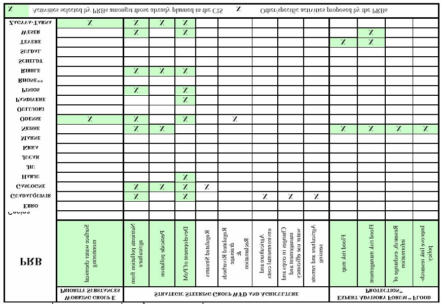
98 97