Overview of the Estuary Partnership s Ecosystem Monitoring Program Synthesis Science Work Group January 2012 Jina Sagar, Research Scientist
|
|
|
- Joel Shields
- 5 years ago
- Views:
Transcription


1 Overview of the Estuary Partnership s Ecosystem Monitoring Program Synthesis Science Work Group January 2012 Jina Sagar, Research Scientist
2 Estuary Partnership The lower Columbia River is an National Estuary Program, one of only 28 in the nation, authorized by Congress in 1987 amendments to Clean Water Act, 320 Established in 1995 by the governors of Washington and Oregon and EPA Lack of focus on the lower river and estuary Bi State findings documented degradation of lower river Partners, incl. federal, state, and local governments; universities; non-profits; industry, etc, participate in the development and implementation of a Comprehensive Conservation and Management Plan (Management Plan) Estuary Partnership developed a long-term aquatic monitoring strategy for the lower Columbia River in 1999 and this strategy is implemented with our Ecosystem Monitoring Program
 Covers multiple 2008 FCRPS BiOp RPAs and Estuary Module RME actions Provides juvenile salmonid stock occurrence, condition, diet and residency Assesses habitat capacity,")
3 Importance of Ecosystem Monitoring Program Only comprehensive assessment of juvenile salmonid habitat in Columbia River estuary (combined look at food web, fish usage, vegetation and water column conditions at each site) Covers multiple 2008 FCRPS BiOp RPAs and Estuary Module RME actions Provides juvenile salmonid stock occurrence, condition, diet and residency Assesses habitat capacity, opportunity and realized function of estuarine habitats key information for regional restoration strategies and salmon recovery planning
 Designed to address data gaps to improve ecosystem restoration and salmonid recovery planning On-going collaboration with UW, PNNL, USGS, and NOAA Supported with funding")
4 Ecosystem Monitoring Program (EMP) Ecosystem Monitoring Program (EMP), 2003 present Develop Columbia River Estuary Ecosystem Classification (Classification) Address habitat and toxic contaminant monitoring gaps ( ) Designed to address data gaps to improve ecosystem restoration and salmonid recovery planning On-going collaboration with UW, PNNL, USGS, and NOAA Supported with funding from BPA Phase 1 (Sept 03 Aug 07) Initiate Columbia River Estuary Ecosystem Classification
5 EMP Original Design In 2004, PNNL developed a statistically robust sampling design to serve as the basis of future site selection (in combination with the Classification). The design included a two-phased approach: Phase I: Inventory sampling to characterize spatial variability throughout the estuary (approx. 120 sites) Phase II: Long-term trends monitoring to track changes in habitats, and provide information about the effects of restoration actions that can be used to evaluate and refine management measures. Both phases involved a stratified rotational sampling design and incorporated both fixed and randomly selected sites proposal included 8 fixed sites (1 per reach) with 12 rotating sites
6 Current EMP Design ( ) To date, the implementation of the proposed design has been limited due to cost constraints The distinction between phases 1 and then 2 in the original design did not occur Estuary Partnership and partners have focused on providing an inventory of habitats (or status ) across the lower river as funding allowed and included a growing number of fixed sites for inter-annual variability (or trends ) Since 2007, focus on finishing Classification (w/bathymetry & landcover datasets) to be able to stratify sampling Sampling occurs primarily in relatively undisturbed tidally influenced emergent wetlands (important rearing habitats for salmon) -Growing number of fixed sites (currently 4); 3-4 status sites per year -Starting in 2007, fish and vegetation sampling co-located at same sites

7 EMP Sampling Stratified by Reach
 Water RC Sand Is. Lord-Walker 1, 2 Cottonwood Is. Sl Lewis R. Mouth Hogan Ranch ('05) McGuire Is. Beacon Rock Wallace Is west ('10) Dibble Slough Martin Is.")
8 Status Sites STATUS SITES Dataset A B C D E F G H Total Sites Vegetation Year 2009, , Number Sites Ryan Is Cottonwood Is. Sm Sl Sandy Is. 1, 2 Sauvie Cove ('05) Water RC Sand Is. Lord-Walker 1, 2 Cottonwood Is. Sl Lewis R. Mouth Hogan Ranch ('05) McGuire Is. Beacon Rock Wallace Is west ('10) Dibble Slough Martin Is. Deer Is ('11) Old Chan. Sandy R. Hardy Slough Jackson Is ('10) Goat Is ('11) Chattam Is. Bradwood Landing ('10) Burke Is ('11) Salmon Year Number Sites Ryan Is Sandy Is. 1, 2 Deer Is ('11) Same as veg Lord-Walker 1 Goat Is ('11) Wallace Is west ('10) Burke Is ('11) Jackson Is ('10) Bradwood Landing ('10) Prey Year Number Sites Same as salmon Same as salmon Same as salmon Same as veg Basic WQ Year Number Site White Island Dibble Slough Old Chan. Sandy R. Sand Is.


9 Fixed Sites Trend Sites Dataset A B C D E F G H Total Sites Vegetation Year 2011, , 2010, 2011, , 2009, 2011, 2012 Number Sites Ilwaco White Is Campbell Sl Franz Lake Cunningham Lake Salmon Year 2011, , 2010, 2011, , 2009, 2011, 2012 Number Sites Ilwaco White Is Campbell Sl Franz Lake Prey Year 2011, , 2010, 2011, , 2009, 2011, 2012 Number Sites Ilwaco White Is Same as salmon Franz Lake Basic WQ Year 2011, , , , 2012 Number Site Ilwaco White Is Campbell Sl Franz Lake Prim Prod Year 2011, , , 2011, , 2012 Number Site Ilwaco White Is Campbell Slough Franz Lake Sec Prod Year 2011, , , , 2012 Number Site Ilwaco White Is Campbell Slough Franz Lake

10 Habitat, salmon, salmon prey and water conditions sampling Vegetation monitoring Sampling during peak biomass (July/August), one day per site Metrics include: % cover along transects, dominant species, vegetation elevation, water level elevation, sediment grain size, water temperature Water conditions Continuous water quality sampling at fixed sites April through July Metrics include: temperature, dissolved oxygen, ph Temperature data collected during fish sampling Fish sampling Monthly sampling between April and September Metrics include: species richness, abundance, CPUE, stock id, length, weight, stomach contents, otoliths for growth rates, marked/unmarked, condition, contaminants Fish prey (macroinvertebrate)sampling Monthly sampling with fish sampling, but gut contents and prey availability taken only when Chinook salmon are caught Metrics include: taxonomy, abundance, biomass, terrestrial vs aquatic origin
, a Wet")
11 Food Web Characteristics LOBO (Land Ocean Biogeochemical Observatory) Platform (2012) -Expand the existing CMOP network of continuous monitoring stations in the Columbia River estuary -Biogeochemical monitoring of the lower Columbia River above the influence of the Willamette River -Metrics include: Wet Labs WQM (temperature, conductivity, chlorophyll a fluorescence, and dissolved oxygen), a Wet Labs CDOM fluorometer (colored dissolved organic matter), a Satlantic SUNA (nitrate and nitrite), and a Wet Labs Cycle-P (dissolved orthophosphate) Zooplankton and phytoplankton sampling (2011/2012) -Zooplankton, phytoplankton and sediment core prey samples collected between April and July at the six fixed sites -Metrics include: biomass and net productivity of phytoplankton and periphyton, stableisotope analysis for plant, plankton, invertebrate and fish tissue, species composition, abundance of sediment core invertebrates -Winter macrophyte biomass slough off for net export of macrodetritus
12 Current EMP Goals and Objectives To comprehensively assess habitat, fish, food web, and abiotic conditions in the lower river, focusing on shallow water and vegetated habitats used extensively by juvenile salmonids for rearing and refugia Conduct long term status and trends monitoring of the biological, physical, and chemical characteristics of estuarine habitats and the opportunity, capacity and realized function they provide juvenile salmonids. In order to close data gaps and inform further restoration strategies
13 EMP Synthesis Comprehensive data analysis and reporting of all habitat, fish, fish prey, and abiotic water conditions data since 2005 (through 2010) Evaluate spatial and temporal variability in habitat, fish, fish prey and water quality Provide baseline data on relatively undisturbed tidally influenced wetlands in the lower Columbia River estuary Preliminary status and trends information for the lower Columbia River estuary Explore relationships between each individual disciplines (fish, fish prey, water conditions, vegetation) to begin to explain patterns Technical Report and published material

14 New monitoring design Why change the sampling design of the EMP? Columbia River Estuary Ecosystem Classification [CREEC] finishes More statistically robust true rotational panel based design Request from BPA and the Council for Estuary Index and EPA for indicators After 5-year synthesis, re-evaluation of goals and objectives; adaptive management
15 Steps to Designing the Monitoring Program Determine goal, objective, actions and assessment questions of interest to resource managers (SWG meeting) Identify candidate indicators for each assessment question. (SWG, April 4-5 workshop of key RME investigators, other working groups for specific indicator portfolio, e.g., indicator species) Determine relevance of indicators to both assessment questions and to ecological structure/function using screening criteria (SWG, April 4-5 workshop of key RME investigators) Determine which are core indicators and provide rationale for each (SWG and April workshop)
, frequency of sampling and sampling period (SWG, Indicator Steering Committee) Establish analysis methods, quality control and data management (SWG, Indicator")
16 Steps to Designing the Monitoring Program Determine population of interest (using Classification) for each core indicator and minimum number of sites (SWG, Indicator Steering Committee) Determine what specifically we measure (metrics), frequency of sampling and sampling period (SWG, Indicator Steering Committee) Establish analysis methods, quality control and data management (SWG, Indicator Steering Committee)
17 Steps to Designing the Monitoring Program Match available funding and projects to list of core indicators (SWG, Indicator Steering Committee) Test each indicator for variability (temporal- within season and year, inter-annual, spatial) (SWG, Indicator Steering Committee) Determine thresholds for indicators (SWG, Indicator Steering Committee) Human and program dimension portfolios of indicators will be developed by Board of Directors and Science to Policy workshop in 2013.
 (EPA, 2000) Provide information useful for management decisions Feasibility and practicality of implementation-methods, logistics, cost")
18 Candidate Indicators Clearly relate to ecological components or processes deemed important in ecological condition Relevant to societal concerns about ecological condition Pertain to one or more assessment questions An indicator should exhibit significantly different responses at distinct points along a condition gradient and be stable (i.e. low spatial and temporal variability) (EPA, 2000) Provide information useful for management decisions Feasibility and practicality of implementation-methods, logistics, cost
 Or an index (benthic")
19 Candidate Indicators Does the indicator complement indicators at other scales and levels of biological organization? The indicator of ecological condition could be a: direct measurement (dissolved oxygen concentration) Or an index (benthic condition)

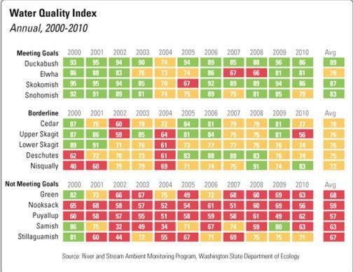
20 Puget Sound Partnership-Vital Signs Example

21 Next Steps Discussion Process Assessment Questions Themes Candidate Indicators
22 Questions?