NWI 2007 NEW TOOLS AND TECHNOLOGIES. Ralph Tiner Wetland Ecologist U.S. Fish & Wildlife Service National Wetlands Inventory Program
|
|
|
- Cameron Haynes
- 5 years ago
- Views:
Transcription
1 NWI 2007 NEW TOOLS AND TECHNOLOGIES Ralph Tiner Wetland Ecologist U.S. Fish & Wildlife Service National Wetlands Inventory Program
2 WHERE WE ARE GOING Improved mapping Expanded wetland classification Preliminary assessments of wetland functions for large geographic areas Other Possibilities: Potential Wetland Restoration Sites Watershed condition re: natural habitat
3 Improved Wetland Mapping Better imagery Larger scale (1:40,000 vs 1:58,000/1:80,000) CIR preferred Digital imagery (e.g., 1-m or 1-ft resolution) Collateral data readily available in digital form Soils data Hydro (stream) data State wetland inventory data Better base maps (DOQQs) GIS technology = operational
4 Wetland Mapping Procedures On-screen photointerpretation Adding undeveloped hydric soil map units (H_wetland type, HPFO ) Base Map = DOQQ (1:12K) PRODUCT will likely show more areas of wetlands and potential wetlands
5
6
7
8
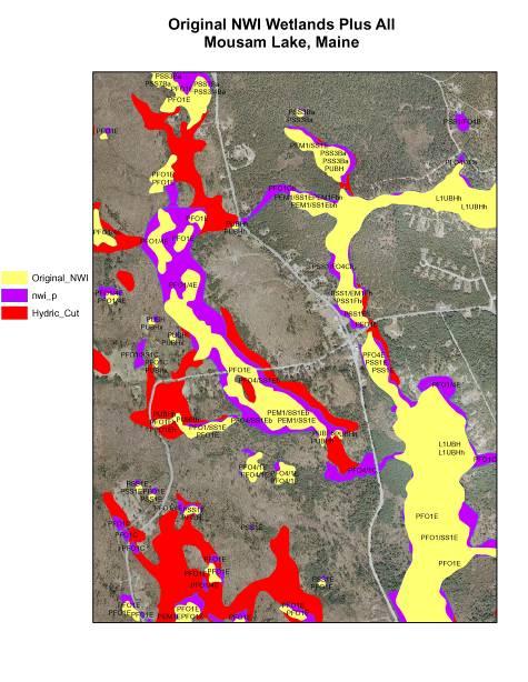
9 Change in Wetland Acreage - Example Original NWI = 414 acres New NWI (photointerpreted only) = 523 acres (+109 acres or 26% increase) New NWI + Undev. Hydric Soils = 718 acres (+195 acres; 37% increase over PIed wetlands; 73% increase over original NWI) Undeveloped Hydric Soils coded as: H-NWI type, such as HPFO1B, HPSS1B
10 New NWI Mapping Technique Should identify More wetland acreage (variable) Smaller wetlands (incl. ponds) Areas with potential for containing wetlands (undeveloped hydric soil map units) Separates photointerpretable wetlands from those we cannot see, but can be interpreted from the soils data 1:12K (DOQQ) base map image
11 Limitations of New NWI Method Can readily do where digital soils data are available Hydric soil wetlands may contain variable amounts of wetland (variable quality of soil surveys) still best available.
12 Expanded Wetland Classification
13 Existing Wetland Classification Characteristics Emphasized To Date (Cowardin et al. 1979) Ecological System Vegetation or Substrate Water Regime Water Chemistry Human and Beaver Impacts
14 FWS Classification Shortcomings Shortcomings No landscape position No landform No water flow direction General pond classification Features important for assessing many functions are lacking Most of these features can be interpreted from the maps
15 Some Questions How many wetlands are there? What is the size range of wetlands? What is the average size of a given wetland type? How many wetlands are in various size classes? How much and how many occur along rivers? along streams? in lake basins? are isolated? are sources of streams? have inflow but no outflow? are connected to other wetlands or waters? What types of ponds are there and what is their extent?
16 Needs for Enhancing the NWI Database Better characterize wetlands for national wetland database Predict wetland functions Help assess significance of wetland losses and gains Predict functions expected from potential wetland restoration sites
17 Add New Descriptors to the NWI Database LLWW Descriptors Landscape Position - relationship between a wetland and an adjacent waterbody or not Landform - shape or physical form Water Flow Path - directional flow of water Waterbody Type more specificity

18 Landscape Position - Marine


19 Landscape Position - Estuarine

20 Landscape Position - Lentic


21 Landscape Position - Lotic RIVER STREAM

22 Landscape Position - Terrene
23 Landforms Slope Island Fringe Floodplain (basin, flat) Interfluve (basin, flat) Basin Flat
24 Water Flow Path Bidirectional Tidal Bidirectional Nontidal Throughflow (perennial, intermittent, entrenched, artificial) Outflow (perennial, intermittent, artificial) Inflow Isolated Paludified
25 Waterbody Types River and Stream Gradients (tidal, dammed, intermittent, high, middle, and low) Lakes (e.g., natural, dammed river valley-reservoir, other dammed, excavated) Ponds (e.g., natural, artificial, beaver, sinkhole, farm, golf, prairie pothole, vernal, Carolina bay, playa, stormwater treatment, sewage lagoon) Estuary (e.g., drowned river valley, bar-built) Ocean (e.g., open, reef-protected, atoll, fjord)
26 APPLICATIONS Better Wetland Characterizations for Study Areas Use for Predicting Wetland Functions for: Watersheds or Larger Areas Historic and Recent Wetland Losses and Gains Potential Wetland Restoration Sites
27 Preliminary Functional Assessment Possible Functions Surface Water Detention Streamflow Maintenance Shoreline Stabilization Nutrient Transformation Coastal Storm Surge Detention Sediment Retention Fish and Shellfish Habitat Waterfowl and Waterbird Habitat Other Wildlife Habitat Conservation of Biodiversity

28 Coordinated Effort To Develop Correlations Reviewed literature Worked with wetland specialists in the Northeast Maine Wetland Advisory Group NYCDEP Nanticoke Wetlands Study Group FWS biologists Others
29 Study Areas Casco Bay Watershed (ME) 3 New York City Water Supply Watersheds 11 Small watersheds (NY) Coastal Bays Watershed (MD) Nanticoke River Watershed (MD/DE) 1998 and Pre-settlement analyses Pennsylvania Coastal Zone Cape Cod and the Islands (MA) data analysis New Jersey (entire state) data analysis Michigan watersheds working with MI DEQ/R3 Selected military bases (several western/southeastern states)
30 Web-based Watershed Reports CD Version and Online reports (View on Internet at: wetlands.fws.gov ) Text Statistics Maps

31 Nanticoke Watershed Surface Water 28% High 69% Moderate (97% of all wetlands)

32 Nanticoke Watershed Waterfowl & Waterbird Habitat 13% High 7% Moderate (20% of all wetlands)
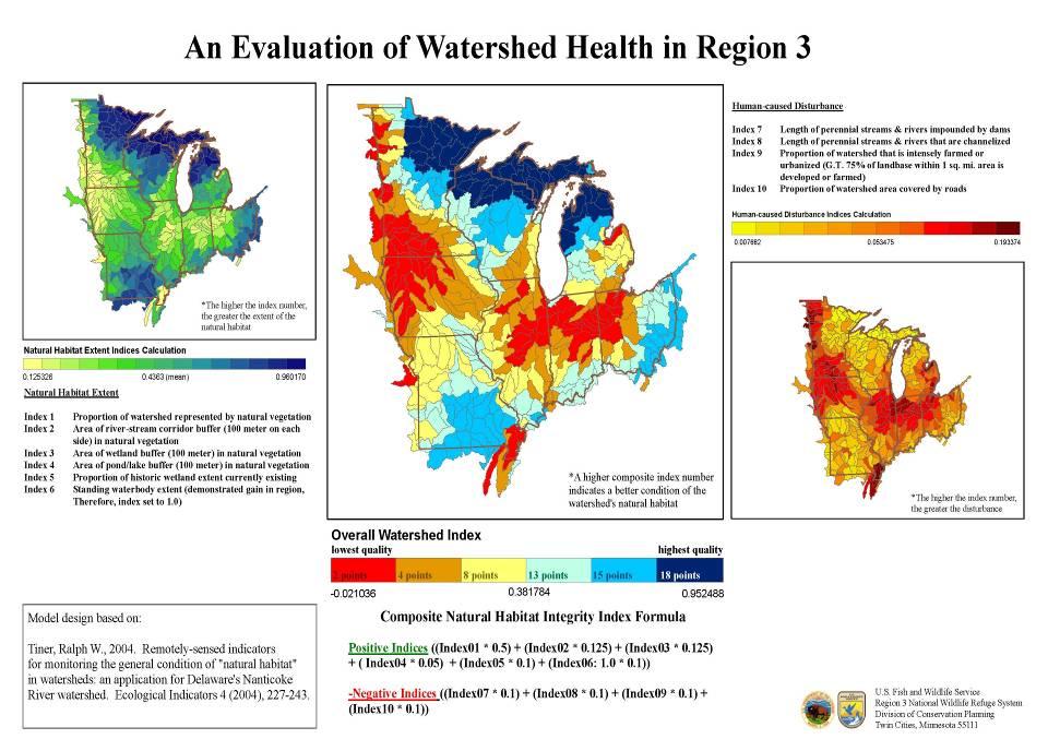
33 Limitations of Landscape-level Assessment First approximation - PRELIMINARY Source data limitations All wetlands not shown Possible upland inclusions All streams not shown Age of data LLWW wetland classifications based largely on map or image interpretation (field review variable) Correlations between functions and characteristics = work in progress (report available for Northeast US; most applicable nationwide, need some modification for habitat functions)
34 Bottomline By adding LLWW descriptors to wetland data the functionality of the NWI database is greatly expanded It becomes a powerful tool to begin reporting status and trends of wetland functions for large geographic areas
35 Other Possibilities for Inventory and Assessment Wetland and waterbody buffers Potential wetland/riparian restoration sites Wetland condition (health) based on remotely sensed data plus available geospatial data Overall condition of watershed in terms of amount of natural habitat remaining


36 Buffers along Rivers, Streams, Wetlands, Lakes, and Ponds
37 Potential Restoration Sites Altered wetlands (e.g., PFO1Ad, Pf) Lost wetlands in restorable condition based on current land use (e.g., hydric soil areas in agricultural use) Nonvegetated riparian corridors (e.g. cropland, pasture, clearing) Nonvegetated wetland buffers

38 Extent of Modified Wetlands Farmed Excavated Impounded Partly Drained ADD Former Wetlands with restoration potential
39 GOING FURTHER WATERSHED ASSESSMENT

40 Extent of Natural Habitat in Watersheds
41 Natural Habitat Integrity Indices Habitat Extent Natural Cover Stream Corridors Wetland Buffers Pond Buffers Lake Buffers Wetland Extent Standing Waterbody Extent Disturbances Damming of Streams Channelization Wetland Alteration Farmed Excavated Impounded Partly Drained Fragmentation by Roads
42
43 NWI Database Greatly expanded due to: GIS and Remote Sensing Technology Availability of Other Digital Data Soils, Streams, Land Use/Cover, Imagery Knowledge of Wetlands and their Functions Interest in Conserving Wetlands from many levels Federal to Local Levels Nonprofit Organizations Average Citizen
44