Vermont Groundwater Monitoring Network: A real-time tool for assessing climatic drought
|
|
|
- Julian Neal
- 5 years ago
- Views:
Transcription


1 Vermont Groundwater Monitoring Network: A real-time tool for assessing climatic drought Richard Kiah, New England Water Science Center June 6, 2017 Lyndonville, VT June 7, 2017 Manchester, VT U.S. Department of the Interior U.S. Geological Survey
2 Outline of talk 1. Drought and Hydrologic Science. 2. USGS-VTDEC monitoring network. 3. Building resiliency.

3 What is Drought? A drought is a period of drier-than-normal conditions that results in water-related problems. Meteorological drought -lack of precipitation Agricultural drought -lack of soil moisture Hydrologic drought -reduced streamflow or groundwater levels

4 Importance of Hydrologic Science Hydrologic Science helps cope with drought in two ways. Drought planning Natural phenomena that will happen again Key to coping with supply drought Drought mitigation Informed management decisions once the drought begins. Current status and recent trend

5 Hydrologic Drought in Vermont : Severe drought throughout VT. Moderate in northern VT : Moderate drought throughout VT : Severe drought through northern VT : Severe drought throughout VT : Moderate drought throughout VT. U.S. Geological Survey Water Supply Paper 2375, 591 p., National Water Summary , Hydrologic Events and Floods and Droughts.

 -3")

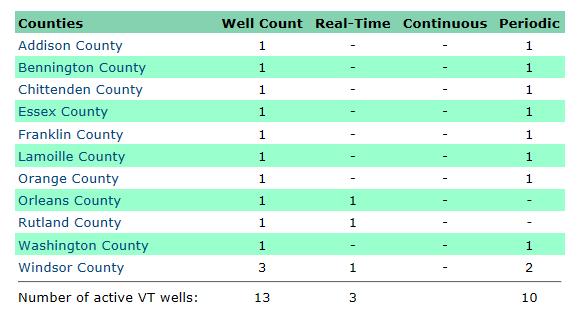
6 USGS-VTDEC GW Monitoring Network Development of real time groundwater information shows great potential. 13 Observation Wells -10 periodic (monthly) -3 real-time (hourly) Long-term record s to present Glacial Aquifer - constructed in overburden VT-RJW 1 Rochester VT-HLW 54 Hartland


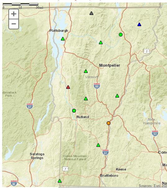
7 Groundwater Monitoring Network
8 Groundwater Monitoring Network
9 Hydrologic Drought GLW 1 HLW 54 GLW 1 HLW 54
10 Building Resiliency Hydrologic monitoring is foundation for making informed decisions Real-time monitoring network Current conditions in context to historical values Hydrologic research Science to support the understanding of groundwater resources Hydrologic response models Evaluating the response of climate and land use on hydrology
11 Historical Groundwater Trends in Northern New England and Relations with Streamflow and Climatic Variables JAWRA Journal of the American Water Resources Association, Volume 49, Issue 5, pages , 21 JUN 2013 DOI: /jawr
12 Hydrologic response models 1. Probability models Likelihood of drought 90 days from now Logistic regression models that predict future conditions at wells (based on current and past conditions ). 2. HyDroDSS Hydrologic drought decision support system Analysis of hydrologic variables that may indicate the risk for streamflowsto be below user-defined flow targets at a designated site of interest. 3. SYE Sustainable-yield estimator SYE estimates streamflow adjusted for current water user from a database of permitted groundwater and surface-water withdrawal and discharge volumes. 4. SWB Soil-water balance model SWB estimates potential recharge at a daily time step using precipitation, air temperature, land-use, hydrologic soil group, flow direction, soil-water capacity. 5. PRMS Precipitation runoff modeling system PRMS is a physical process based modeling system that evaluates the response of climate and land use on streamflow and general watershed hydrology. 6. Coupled groundwater models(gsflow) MODFLOW & PRMS
13 Statistical groundwater level prediction 3-monthforecastmodel Blue line: monthlygwlevel (red points are below threshold level) Green bars: probability that the GW level will be at or below the threshold level three months later Dudley, R.W., Hodgkins, G.A., and Dickinson, J.E., 2017, Forecasting the probability of future groundwater levels declining below specified low thresholds in the conterminous U.S.: Journal of the American Water Resources Association (JAWRA), <in review> 13
14 HyDroDSS: Hydrologic Drought Decision Support System Developed with Rhode Island WRB: Input data USGS streamflow and groundwater data Monthly precipitation from NWS Permitted withdrawals Output data Estimates of daily mean flow Report: Granato, G.E., 2014, Hydrologic Drought Decision Support System (HyDroDSS): U.S. Geological Survey Open-File Report , 91 p., with CD ROM,
 Streamflow values at ungagedlocations adjusted for withdrawals and discharges Report: Archfield, S.A., Vogel, R.M.")
15 Sustainable Yield Estimator Statewide model, with MA DEP: Input data Flow-duration at gaged sites used to estimate flow at ungaged. Permitted withdrawals and discharges Output data (integrated with StreamStats) Streamflow values at ungagedlocations adjusted for withdrawals and discharges Report: Archfield, S.A., Vogel, R.M., Steeves, P.A., Brandt, S.L., Weiskel, P.K., and Garabedian, S.P., 2010, The Massachusetts Sustainable-Yield Estimator: A decision-support tool to assess water availability at ungagedstream locations in Massachusetts: U.S. Geological Survey Scientific Investigations Report , 41 p. plus CD-ROM.
 recharge, soil moisture, snowpack, streamflow, etc. PILOT report: Bjerklie, D.M.")
16 New Hampshire PRMS Model Statewide model, with NH DES Coastal Program and NH HHS BRACE program: GCMs as input data updated regularly precipitation and temp and wind, etc. Output data (in GRANIT system GIS) recharge, soil moisture, snowpack, streamflow, etc. PILOT report: Bjerklie, D.M. et al, 2015, Simulating hydrologic response to climate change scenarios in four selected watersheds of New Hampshire: U.S. Geological Survey Scientific Investigations Report , 53 p., STATEWIDE report: Bjerklie, D.M. and Luke Sturtevant, 2017, Simulated Hydrologic Response to Climate Change During the 21st Century in New Hampshire, Scientific Investigations Report 2017 XXX (in review)
17 CONTACT: Richard Kiah, Chief, NH-VT Hydrologic Network Operations New England Water Science Center