Prepared for: City of Jeffersonville. November Prepared by
|
|
|
- Pamela West
- 5 years ago
- Views:
Transcription

1 JEFFERSONVILLE STORMWATER MASTER PLAN HYDRAULICS APPENDIX JEFFERSONVILLE, INDIANA Prepared for: City of Jeffersonville November 2011 Prepared by Christopher B. Burke Engineering, Ltd. 115 W. Washington St., Suite 1368-South Indianapolis, Indiana CBBEL Project Number
2 November 2011 Jeffersonville Stormwater Master Plan Hydraulics Appendix TABLE OF CONTENTS Page LIST OF TABLES... ii LIST OF EXHIBITS... ii LIST OF APPENDICES... ii 1.0 INTRODUCTION HYDRAULIC ANALYSIS INTRODUCTION HEC-RAS INPUT DATA Topographic Work Map Study Reach Flow Data Starting Water Surface Elevation Cross Section Geometric Data Manning's Roughness Coefficients Calibration Ineffective Flow and Blocked Obstructions Bridges Culverts Critical Depths Floodway LANCASSANGE CREEK FINAL RESULTS OF HYDRAULIC ANALYSIS REFERENCES... 6 Christopher B. Burke Engineering, Ltd. i
3 November 2011 Jeffersonville Stormwater Master Plan Hydraulics Appendix LIST OF TABLES Page 1. Peak Discharges Used in Model... 3 LIST OF EXHIBITS 1. Lick Run Topographic Workmap 2. Lick Run Tributary 4 Topographic Workmap 3. Lick Run Trib 1 Topographic Workmap 4. Lancassange Creek Topographic Workmap 5. Lentzier Creek Topographic Workmap 6. Battle Creek Topographic Workmap 7. Jenny Lind Run Topographic Workmap LIST OF APPENDICES 1. Lick Run Coordinated Discharge Curve 2. Lancassange Creek Flood Profile 3. HEC-RAS Models Output Christopher B. Burke Engineering, Ltd. ii
 hydraulic analysis of reaches of seven streams in Jeffersonville, Clark County, Indiana.")
4 November 2011 Jeffersonville Stormwater Master Plan Hydraulics Appendix 1.0 INTRODUCTION This report documents the results of a Christopher B. Burke Engineering, Ltd. (CBBEL) hydraulic analysis of reaches of seven streams in Jeffersonville, Clark County, Indiana. The analysis was completed to determine approximate base flood elevations for reaches of Lick Run, Lick Run Tributary 4, Lick Run Tributary 1, Lancassange Creek, Lentzier Creek, Battle Creek and Jenny Lind Run to determine any potential flooding areas along the streams. This analysis along with the Preliminary Flood Insurance Study (FIS) delineations provides floodplain limits for all stream reaches within Jeffersonville that have one square mile or over drainage area as determined by the Indiana Department of Natural Resources (IDNR). The study reaches are located throughout Jeffersonville as shown outlined in red in Figure 1. Figure 1: Study Reaches Christopher B. Burke Engineering, Ltd. 1
5 November 2011 Jeffersonville Stormwater Master Plan Hydraulics Appendix 2.0 HYDRAULIC ANALYSIS 2.1 INTRODUCTION This section of the report presents the modeling developed for the hydraulic analysis for the seven stream reaches. The modeling was completed in accordance with the Indiana Department of Natural Resources (IDNR) Modeling Guidelines for approximate studies. 2.2 HEC-RAS INPUT DATA The hydraulic analysis developed for this analysis was completed using the Army Corps of Engineers HEC-RAS computer program, version 4.1 for all the streams except Lancassange Creek, which is discussed in Section 2.3. The nature and source of information that was used to develop the model for the analysis of the streams is provided below Topographic Work Map CBBEL used the Jeffersonville 2-foot contour interval topography provided by the City of Jeffersonville in 2011, as the base map for Lick Run, Lick Run Tributary 4, Lick Run Tributary 1, and Lancassange Creek. The vertical datum for the mapping is NAVD CBBEL used the USGS 5-foot contour interval topography, dated 1993, as the base map for Lentzier Creek, Battle Creek, and Jenny Lind Run. The vertical datum for this mapping is NGVD A copy of the map, showing the location and orientation of cross sections used in the hydraulic modeling is provided as Exhibits 1-7 for each of the stream reaches Study Reaches The study reach for Lick Run starts at Cross Section from the detailed modeling created for the current Preliminary Flood Insurance Study (FIS) and continues upstream approximately 3.8 miles to approximately 1,060 feet downstream of Veteran s Parkway. The study reach for Lick Run Tributary 4 starts at the confluence with Lick Run and continues upstream approximately 0.76 miles. The study reach for Lick Run Tributary 1 starts at the confluence with Lick Run and continues upstream approximately 0.58 miles. The study reach for Lentzier Creek starts at Cross Section 4.72 from the detailed modeling for the preliminary FIS and continues upstream approximately 1.1 miles. The study reach for Battle Creek starts at the confluence with the Ohio River and continues upstream approximately 0.7 miles. The study reach for Jenny Lind Run starts at the confluence with the Ohio River and continues upstream approximately 0.4 miles. Christopher B. Burke Engineering, Ltd. 2
6 November 2011 Jeffersonville Stormwater Master Plan Hydraulics Appendix Flow Data Flow data for the simulation of the 100-year storm event for Lick Run was taken from the discharge at the upstream limit of the Preliminary FIS model mentioned in the previous section. Flow data for Lick Run Tributary 4 and Lick Run Tributary 1 were taken from the existing Lick Run Coordinated Discharge Graph, which is included in Appendix 1. Flow data for Lentzier Creek was taken from the discharge at the upstream limit of the Preliminary FIS model. Flow data for Battle Creek and Jenny Lind Run were taken from the CBBEL hydrologic analysis discussed in the Hydrologic Appendix. Table 1 summarizes the discharges used for each of the streams. Stream Table 1 Peak Discharges Used in the Hydraulic Models HEC-RAS Cross Section Reach Recurrence Interval (Year) 100 Peak Discharge (cfs) Lick Run Lick Run Tributary Lick Run Tributary Lentzier Creek Battle Creek Jenny Lind Run Starting Water Surface Elevation The starting water surface elevation for the 100-year storm event for Lick Run was taken from the water surface elevation at Cross Section in the Preliminary FIS model. The starting water surface elevation for Lick Run Tributary 4 was taken from the water surface elevation at Cross Section from the Preliminary FIS model of Lick Run. The starting water surface elevations form Lick Run Tributary 1, Lentzier Creek, Battle Creek, and Jenny Lind Run were calculated by using the slope-area method or normal depth Cross Section Geometric Data Cross-section geometric data was taken directly from the topographic base map described above. All cross sections were aligned to best represent a perpendicular orientation to flow. Christopher B. Burke Engineering, Ltd. 3
7 November 2011 Jeffersonville Stormwater Master Plan Hydraulics Appendix Manning's Roughness Coefficients Manning's roughness coefficients for Lick Run, Lick Run Tributary 4, and Lick Run Tributary 1 were taken from the Preliminary FIS modeling for the detailed study of Lick Run. Manning s roughness coefficients for Lick Run and Lick Run Tributary 4 are for the channel and for the overbanks. For Lick Run Tributary 1, they are 0.05 for the channel and 0.08 for the overbanks. The Manning s roughness coefficients for Lentzier Creek were taken from the downstream modeling for the stream in the Preliminary FIS. The Manning s roughness coefficients are 0.06 for the channel and 0.08 for the overbanks. The Manning s roughness coefficients for Battle Creek and Jenny Lind Run were taken from aerial photographs, and they are 0.05 for the channel and 0.08 for the overbanks Calibration No calibration was performed on the streams Ineffective Flow and Blocked Obstructions Ineffective flow limits were modeled for Lick Run Tributary 4 and Lick Run Tributary 1. The ineffective flow limits were used to reflect high ground not captured in the cross section data Bridges Since the modeling was approximate, existing bridges were not included in the model Culverts Since the modeling was approximate, existing culverts were not included in the model Critical Depths No critical depths were calculated for the 100-year profile Floodway No floodway analysis was performed on the streams. Christopher B. Burke Engineering, Ltd. 4
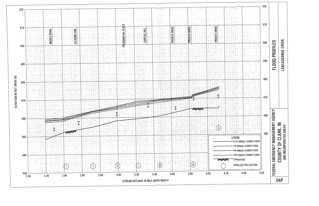
8 November 2011 Jeffersonville Stormwater Master Plan Hydraulics Appendix 2.3 LANCASSANGE CREEK Due to the short study reach of Lancassange Creek, a hydraulic model was not developed for this stream. The study reach for Lancassange Creek starts at the upstream limit of the FIS (Section O) and continues upstream for approximately 0.15 miles. The approximate 100-year water surface elevation for the additional study reach was determined based on the assumption that the depth of flow at the upstream end of the detailed study in the FIS would be applicable for the short additional reach studied for this analysis. Based on the Lancassange Creek Flood Profile Sheet 04P in the FIS, the depth of flow at the upstream limit was 10.2 feet. The Lancassange Creek Flood Profile from the FIS is included in Appendix 2. The 10.2 foot depth was added to the channel invert at each of the cross sections to determine the approximate water surface elevations for the current study reach. 2.4 FINAL RESULTS OF HYDRAULIC ANALYSIS Utilizing the input data described in Section 2.2, HEC-RAS existing condition models for the streams were developed. A copy of the model output for each stream is included as Appendix 3. A disk with digital copies of the models and the floodplain mapping shapefiles are provided as in the Hydraulics Appendix on the master CD provided for the Master Plan. Christopher B. Burke Engineering, Ltd. 5
9 November 2011 Jeffersonville Stormwater Master Plan Hydraulics Appendix 3.0 REFERENCES City of Jeffersonville, 2-foot contour interval topography, NAVD 1988 datum. USGS, 5-foot contour interval topography, NAVD 1988 datum, Dated Christopher B. Burke Engineering, Ltd. 6
10 November 2011 Jeffersonville Stormwater Master Plan Hydraulics Appendix APPENDIX 1 LICK RUN COORDINATED DISCHARGE CURVE Christopher B. Burke Engineering, Ltd.

11 Year Flood 2 Discharge (Cfs) MOUTH State of Indiana DEPARTMENT OF NATURAL RESOURCES Division of Water Coordinated Discharge Graph Lick Run CLARK COUNTY, IN Total Drainage Area (Square Miles) October 2005
12
13
14
15
16
17
18

19
20
SECTION IV WATERSHED TECHNICAL ANALYSIS
 A. Watershed Modeling SECTION IV WATERSHED TECHNICAL ANALYSIS An initial step in the preparation of this stormwater management plan was the selection of a stormwater simulation model to be utilized. It
SAW MILL RIVER DAYLIGHTING ANALYSIS AT RIVER PARK CENTER
 SAW MILL RIVER DAYLIGHTING ANALYSIS AT RIVER PARK CENTER Prepared for: Struever Fidelco Cappelli LLC McLaren Project No. 6 August 28 TABLE OF CONTENTS. INTRODUCTION 2. SAW MILL RIVER: FEMA STUDY... 2..
The Beckett s Run Experience. Fort Wayne, Indiana
 The Beckett s Run Experience Fort Wayne, Indiana Introductions Charlie Cochran City of Fort Wayne, Wet Weather Storm & Sewer Engineering Jason Durr, PE Christopher B. Burke Engineering, LLC 2 A Little
Beaver Brook Flood Study
 Alternatives Analysis Beaver Brook Flood Study Pelham, New Hampshire PREPARED FOR Town of Pelham 6 Village Green Pelham, NH 03076 PREPARED BY 101 Walnut Street PO Box 9151 Watertown, MA 02471 617.924.1770
APPENDIX J-3 Technical Report on Airport Drainage, Northern Sector Airport and Ordinance Creek Watershed, Airport Creek Hydrologic Models
 APPENDIX J-3 Technical Report on Airport Drainage, Northern Sector Airport and Ordinance Creek Watershed, Airport Creek Hydrologic Models Introduction Technical Report on Airport Drainage Appendix J-3:
Hydraulic Report. County Road 595 Bridge over Mulligan Creek. Prepared By AECOM Brian A. Hintsala, P.E
 Prepared for: Prepared by: Marquette County Road Commission AECOM Ishpeming, MI Marquette, MI 60240279 December 9. 2011 Hydraulic Report County Road 595 Bridge over Mulligan Creek Prepared By AECOM Brian
Engineering Report Preliminary Floodplain Study. Executive Summary
 Executive Summary Engineering Report Preliminary Floodplain Study The Federal Emergency Management Agency (FEMA) has updated the Flood Insurance Rate Maps (FIRM) for Finney County, including the City of
SECTION III: WATERSHED TECHNICAL ANALYSIS
 Trout Creek Watershed Stormwater Management Plan SECTION III: WATERSHED TECHNICAL ANALYSIS A. Watershed Modeling An initial step this study of the Trout Creek watershed was the selection of a stormwater
Review Budget and Timeline for XP-SWMM Phase II Project and Determine Next Steps
 Memorandum To: Item 5C - Review Budget and Timeline for XP-SWMM Phase II Project and Determine Next Steps Project: 23/27-0051 2015 5C Review Budget and Timeline for XP-SWMM Phase II Project and Determine
Hydraulic Report. County Road 595 Bridge over Dead River. Prepared By AECOM Brian A. Hintsala, P.E
 Prepared for: Prepared by: Marquette County Road Commission AECOM Ishpeming, MI Marquette, MI 60240279 December 9, 2011 Hydraulic Report County Road 595 Bridge over Dead River Prepared By AECOM Brian A.
Cherokee County Future Conditions Floodplain Development
 TECHNICAL MEMORANDUM Cherokee County Future Conditions Floodplain Development Prepared for: Prepared by: Geoff Morton, P.E., County Engineer Cherokee County Richard Greuel, P.E.,, Inc. Richard Taylor,
KAY COUNTY, OKLAHOMA. Federal Emergency Management Agency AND INCORPORATED AREAS
 KAY COUNTY, OKLAHOMA AND INCORPORATED AREAS Notice: This preliminary FIS report includes only revised Flood Profiles. See Notice to Flood Insurance Users page for additional details. Community Name Community
Stormwater Erosion Control & Post-Construction Plans (Stormwater Quality Plans)
") Stormwater Erosion Control & Post-Construction Plans (Stormwater Quality Plans) Allen County Stormwater Plan Submittal Checklist The following items must be provided when applying for an Allen County Stormwater
Stormwater Erosion Control & Post-Construction Plans (Stormwater Quality Plans) Allen County Stormwater Plan Submittal Checklist The following items must be provided when applying for an Allen County Stormwater
JACKSON COUNTY, GEORGIA AND INCORPORATED AREAS
 Jackson County JACKSON COUNTY, GEORGIA AND INCORPORATED AREAS COMMUNITY NAME COMMUNITY NUMBER ARCADE, CITY OF 130597 BRASELTON, TOWN OF 130343 COMMERCE, CITY OF 130212 HOSCHTON, CITY OF 130344 JACKSON
Hydrologic Calibration:
 Hydrologic Calibration: UPDATE OF EFFECTIVE HYDROLOGY FOR MARYS CREEK October 2010 Agenda Background Hydrologic model Calibrated rainfall Hydrologic calibration 100 year discharges, Existing Conditions
Stormwater Management Studies PDS Engineering Services Division ES Policy # 3-01
 Stormwater Management Studies PDS Engineering Services Division Revised Date: 2/28/08 INTRODUCTION The City of Overland Park requires submission of a stormwater management study as part of the development
Airport Master Plan. Floodplain Report. Prepared by: Prepared for: Illinois Department of Transportation
 Airport Master Plan Floodplain Report Prepared by: Prepared for: Illinois Department of Transportation July 10, 2013 Table of Contents Topic Page Number Cover Sheet... Cover Sheet Table of Contents...
DAWSON COUNTY, GEORGIA
 DAWSON COUNTY, GEORGIA AND INCORPORATED AREAS Dawson County COMMUNITY NAME COMMUNITY NUMBER DAWSON COUNTY 130304 (UNINCORPORATED AREAS) DAWSONVILLE, CITY OF 130064 SEPTEMBER 26, 2008 FLOOD INSURANCE STUDY
LANIER COUNTY, GEORGIA
 LANIER COUNTY, GEORGIA AND INCORPORATED AREAS Community Name Community Number Lanier County LAKELAND, CITY OF 130120 LANIER COUNTY (UNINCORPORATED AREAS) 130555 Effective: December 17, 2010 FLOOD INSURANCE
DAVIESS COUNTY, KENTUCKY AND INCORPORATED AREAS Daviess County
 DAVIESS COUNTY, KENTUCKY Daviess County COMMUNITY NAME COMMUNITY NUMBER DAVIESS COUNTY (UNINCORPORATED AREAS) 210062 OWENSBORO, CITY OF 210063 *WHITESVILLE, CITY OF 210438 *NON-FLOODPRONE COMMUNITY REVISED
Southeast Policy Area Drainage Study
 Southeast Policy Area Drainage Study Prepared for City of Elk Grove January 2014 448-00-12-03 Table of Contents 1.0 Introduction... 1 2.0 Watershed Description... 1 3.0 Drainage Plan Concept... 1 4.0
Dam Failure Analysis. Olivotti Lake Dam. Houle Enterprises, LLC. (Final) Oshkosh, Wisconsin. Lincoln County, Wisconsin. Report prepared for
 Oshkosh, Wisconsin. Lincoln County, Wisconsin. Report prepared for") Dam Failure Analysis (Final) Olivotti Lake Dam Lincoln County, Wisconsin Report prepared for Houle Enterprises, LLC Oshkosh, Wisconsin Report prepared by www.meadhunt.com July 2012 Table of Contents Table
Dam Failure Analysis (Final) Olivotti Lake Dam Lincoln County, Wisconsin Report prepared for Houle Enterprises, LLC Oshkosh, Wisconsin Report prepared by www.meadhunt.com July 2012 Table of Contents Table
Chicago Waterways Tail Water Conditions Modeling
 MEMORANDUM Chicago Waterways Tail Water Conditions Modeling TO: FROM: Tim Coleman, Phil Bonn, CH2MHILL Marion Kessy, FLUIDCLARITY DATE: June 1, 2008 PROJECT NUMBER: FCL 7000 Purpose This memorandum is
DESIGN DOCUMENTATION REPORT APPENDIX C HYDROLOGY AND HYDRAULICS
 January 8, 2016 WP-42I FINAL SUBMITTAL DESIGN DOCUMENTATION REPORT APPENDIX C HYDROLOGY AND HYDRAULICS Fargo-Moorhead Flood Risk Management Project In-Town Levees Mickelson Levee Extension WP-42I Engineering
Technical Memorandum. Hydraulic Analysis Smith House Flood Stages. 1.0 Introduction
 Technical Memorandum Hydraulic Analysis Smith House Flood Stages 1.0 Introduction Pacific International Engineering (PIE) performed a hydraulic analysis to estimate the water surface elevations of the
Bridge Replacement Project. Preliminary Hydraulic Study. Lincoln, California BRLS-5089 (021) BRIDGE 19C Mcbean Park Drive at Auburn Ravine
 BRIDGE 19C Mcbean Park Drive at Auburn Ravine") Bridge Replacement Project Preliminary Hydraulic Study Lincoln, California BRLS-5089 (021) BRIDGE 19C 0059 Mcbean Park Drive at Auburn Ravine Prepared By: Prepared By: Date 11/25/2014 Thomas S. Plummer
Bridge Replacement Project Preliminary Hydraulic Study Lincoln, California BRLS-5089 (021) BRIDGE 19C 0059 Mcbean Park Drive at Auburn Ravine Prepared By: Prepared By: Date 11/25/2014 Thomas S. Plummer
Hey and Associates, Inc.
 Hey and Associates, Inc. Table 1: 100-Year Study Existing Conditions Discharges and Elevations vs. FIS Results Location Existing FIS Q (cfs) Existing FIS Elevation Existing XP- SWMM Q (cfs) Existing XP-SWMM
Pajaro River Watershed Flood Prevention Authority. Phase 3 and 4a. Pajaro River Watershed Study
 Pajaro River Watershed Flood Prevention Authority Phase 3 and 4a FEBRUARY 2005 Funding for this project has been provided in full or in part through a contract with the SWRCB pursuant to the Costa-Machado
TABLE OF CONTENTS. 1.0 Background Watershed Description Hydrology - HEC-HMS Models Hydraulics - HEC-RAS Models...
 TABLE OF CONTENTS 1.0 Background... 1 2.0 Watershed Description... 1 3.0 Hydrology - HEC-HMS Models... 2 3.1 Hydrologic Approach... 2 3.2 Drainage Areas... 2 3.3 Curve Numbers... 2 3.4 Lag Times... 3 3.5
WALKER COUNTY, GEORGIA
 WALKER COUNTY, GEORGIA AND INCORPORATED AREAS Walker County Community Name Community Number CHICKAMAUGA, CITY OF 130181 LAFAYETTE, CITY OF 130182 LOOKOUT MOUNTAIN, CITY OF 130448 ROSSVILLE, CITY OF 130183
Technical Memorandum No River Geometry
 Pajaro River Watershed Study in association with Technical Memorandum No. 1.2.5 River Geometry Task: Collection and Analysis of River Geometry Data To: PRWFPA Staff Working Group Prepared by: J. Schaaf
Floodplain Special Review
 Larimer County Engineering Dept. Procedural Guide for: August 1, 2007 Floodplain Special Review Floodplain Special Review Process The floodplain special review process contains the following steps: 1.
Floodplain Development
 Floodplain Development Floodplain Regulations State: Part 31 of Public Act 451 Local: Federal: Building Codes, Zoning and Floodplain Management Ordinances National Flood Insurance Program Floodplain:
PEARCE CREEK CONFINED DISPOSAL AREA MODIFICATION
 US Army Corps of Engineers Philadelphia District PEARCE CREEK CONFINED DISPOSAL AREA MODIFICATION CECIL COUNTY MARYLAND STORMWATER MANAGEMENT PLAN NARRATIVE INITIAL SUBMISSION JUNE 2014 1 PEARCE CREEK
Little Bear Brook Flood Hazard Assessment and Redevelopment Area Regional Stormwater Management Analysis. Progress Meeting
 Little Bear Brook Flood Hazard Assessment and Redevelopment Area Regional Stormwater Management Analysis Progress Meeting June 30, 2014 Princeton Hydro, LLC and SWM Consulting, LLC Project Team West Windsor
LOWER SWEETWATER CREEK
 LOWER SWEETWATER CREEK STORMWATER MANAGEMENT MASTER PLAN Prepared for the Hillsborough County Board of County Commissioners By Public Works Department/Engineering Division Stormwater Management Section
IMPROVED MODELING OF THE GREAT PEE DEE RIVER: DOCUMENTATION IN SUPPORT OF FEMA APPEAL. Horry County, South Carolina
 IMPROVED MODELING OF THE GREAT PEE DEE RIVER: DOCUMENTATION IN SUPPORT OF FEMA APPEAL Horry County, South Carolina July 15, 2016 CONTENTS 1 Introduction... 2 2 Hydrology... 3 3 HEC-RAS Model... 7 3.1 Cross
San Luis Obispo Creek Watershed Hydrologic Model Inputs
 Jeff Werst San Luis Obispo County Department of Public Works 1050 Monterey Street San Luis Obispo CA 93408 December 14, 2007 Subject: San Luis Obispo Creek Watershed Hydrology and Hydraulic Model Dear
COLUMBIA COUNTY, GEORGIA
 COLUMBIA COUNTY, GEORGIA AND INCORPORATED AREAS Community Name Community Number COLUMBIA COUNTY 130059 (UNINCORPORATED AREAS) GROVETOWN, CITY OF 130265 HARLEM, CITY OF 130266 COLUMBIA COUNTY Effective:
STEPHENS COUNTY, OKLAHOMA AND INCORPORATED AREAS
 STEPHENS COUNTY, OKLAHOMA AND INCORPORATED AREAS Community Name Community Number BRAY, TOWN OF 400536 COMANCHE, CITY OF 405376 DUNCAN, CITY OF 400202 EMPIRE CITY, CITY OF 400520 LOCO, CITY OF 400521 MARLOW,
OCONEE COUNTY, GEORGIA
 OCONEE COUNTY, GEORGIA AND INCORPORATED AREAS Oconee County Community Name Community Number *BISHOP, TOWN OF 130620 *BOGART, CITY OF 130490 NORTH HIGH SHOALS, TOWN OF 130368 OCONEE COUNTY 130453 (UNINCORPORATED
TECHNICAL GUIDANCE and CASE STUDY for INEFFECTIVE FLOW and CONVEYANCE SHADOW AREAS
 Utilities electric stormwater wastewater water 700 Wood St. PO Box 580 Fort Collins, CO 80522 970.221.6700 970.221.6619 fax 970.224.6003 TDD utilities@fcgov.com fcgov.com/utilities TECHNICAL GUIDANCE and
Urban Study. Rocky Branch Watershed Columbia, South Carolina. June 1, Project No
 Urban Study Rocky Branch Watershed Columbia, South Carolina Prepared for: City of Columbia 1136 Washington Street Columbia, SC 29217 Prepared by: AMEC Environment & Infrastructure, Inc. 720 Gracern Road
Master Watershed Study Final Report Volume 1
 City of DEL RIO Master Watershed Study Final Report Volume 1 SEPTEMBER 2012 TABLE OF CONTENTS VOLUME I Page 1. Introduction 1.1 Background 1-1 1.2 Authorization 1-1 1.3 Scope of Study 1-2 1.4 Study Limits
FLOOD INSURANCE STUDY
 FLOOD INSURANCE STUDY BERKELEY COUNTY, WEST VIRGINIA AND INCORPORATED AREAS COMMUNITY NAME COMMUNITY NUMBER Berkeley County BERKELEY COUNTY (UNINCORPORATED AREAS) 540282 *HEDGESVILLE, TOWN OF 545550 MARTINSBURG,
CLAY STREET BRIDGE REPLACEMENT
 HYDROLOGY /HYDRAULICS REPORT. EL DORADO COUNTY CLAY STREET BRIDGE REPLACEMENT Prepared by: Joseph Domenichelli Domenichelli & Associates 1107 Investment Blvd., Suite 145 El Dorado Hills, California 95762
DRAINAGE SUBMITTAL CHECKLIST
 Project Name: Firm Name: Map ID: Engineer: Address: City: State: Zip: Phone Number: Fax Number: Property Owner: Address: City: State: Zip: Reviewed By: Date Received: Date Accepted for Review: The following
GORDON COUNTY, GEORGIA
 GORDON COUNTY, GEORGIA AND INCORPORATED AREAS Gordon County Community Name Community Number Calhoun, City of 130095 Fairmount, City of 130661 Gordon County 130094 (Unincorporated Areas) Plainville, City
A Hydrologic Study of the. Ryerson Creek Watershed
 A Hydrologic Study of the Ryerson Creek Watershed Dave Fongers Hydrologic Studies Unit Land and Water Management Division Michigan Department of Environmental Quality May 8, 2002 Table of Contents Summary...2
Appendix C, Attachment 4 June 11, Diversion Channel Outlet Hydraulic Modeling RAS and ADH
 Diversion Channel Outlet Hydraulic Modeling RAS and ADH 11 June 2012 1 Contents Introduction... 3 HEC-RAS modeling of Outlet... 3 Transition Structure Geometry... 3 ADH Modeling of Outlet and Floodplain...
December 7, Dr. Christine Pomeroy University of Utah Civil and Environmental Engineering MCE Salt Lake City, UT. Dear Dr.
 December 7, 2012 Dr. Christine Pomeroy University of Utah Civil and Environmental Engineering MCE 2042 Salt Lake City, UT 84112 Dear Dr. Pomeroy, The following document is the final report of the Red Butte
Development of Stage-Discharge Ratings for Site 2240 Bear Creek at Cold Spring
 Development of Stage-Discharge Ratings for Site 2240 Bear Creek at Cold Spring Prepared for: Urban Drainage and Flood Control District 2480 W. 26 th Avenue Suite 156-B Denver, CO 80211 May 19, 2006 (Rev
Modeling a Complex Hydraulic Environment Using a 1-D Approach Supplemented with Simple 2-D Principles Manas Borah Ed Dickson June 5, 2014
 ASFPM 2014 Annual Conference Modeling a Complex Hydraulic Environment Using a 1-D Approach Supplemented with Simple 2-D Principles Manas Borah Ed Dickson June 5, 2014 Agenda Overview and Background Hydrology
TIFT COUNTY, GEORGIA AND INCORPORATED AREAS. Tift County. Revised: September 29, 2010 FLOOD INSURANCE STUDY NUMBER 13277CV000A
 TIFT COUNTY, GEORGIA AND INCORPORATED AREAS Community Name Community Number Tift County OMEGA, CITY OF 130552 TIFT COUNTY (UNINCORPORATED AREAS) 130404 TIFTON, CITY OF 130171 TY TY, CITY OF 130172 Revised:
NEW CASTLE COUNTY, DELAWARE, AND INCORPORATED AREAS
 NEW CASTLE COUNTY, DELAWARE, AND INCORPORATED AREAS Community Name Community Number ARDEN, VILLAGE OF 100052 *AREDENCROFT, VILLAGE OF 100057 ARDENTOWN, VILLAGE OF 100058 *BELLEFONTE, TOWN OF 100021 DELAWARE
Appendix VI: Illustrative example
 Central Valley Hydrology Study (CVHS) Appendix VI: Illustrative example November 5, 2009 US Army Corps of Engineers, Sacramento District Prepared by: David Ford Consulting Engineers, Inc. Table of contents
Upper Des Plaines River Feasibility Study. Appendix A Hydrology and Hydraulics
 Upper Des Plaines River Feasibility Study Appendix A Hydrology and Hydraulics August 2013 (DRAFT) Study Partnership Illinois Department of Natural Resources (IDNR) Southeastern Wisconsin Regional Planning
BLACK HAWK COUNTY, IOWA AND INCORPORATED AREAS
 VOLUME 2 OF 3 BLACK HAWK COUNTY, IOWA AND INCORPORATED AREAS COMMUNITY NAME BLACK HAWK COUNTY, UNINCORPORATED AREAS COMMUNITY NUMBER 190535 CEDAR FALLS, CITY OF 190017 DUNKERTON, CITY OF 190018 ELK RUN
S.R. 0944, Section 015 (Wertzville Road) Bridge over the West Branch of Simmons Creek. Silver Spring Township Cumberland County.
 Bridge over the West Branch of Simmons Creek. Silver Spring Township Cumberland County.") Hydrologic and Hydraulic Report For S.R. 0944, Section 015 (Wertzville Road) Bridge over the West Branch of Simmons Creek Silver Spring Township Cumberland County August 13, 2003 Prepared For Pennsylvania
Hydrologic and Hydraulic Report For S.R. 0944, Section 015 (Wertzville Road) Bridge over the West Branch of Simmons Creek Silver Spring Township Cumberland County August 13, 2003 Prepared For Pennsylvania
CARROLL COUNTY, GEORGIA
 CARROLL COUNTY, GEORGIA AND INCORPORATED AREAS Community Name Community Number BOWDON, CITY OF 130244 CARROLL COUNTY 130464 (UNINCORPORATED AREAS) CARROLLTON, CITY OF 130208 MOUNT ZION, CITY OF 130286
Development of a Stage-Discharge Rating for Site Van Bibber Creek at Route 93
 Development of a Stage-Discharge Rating for Site 330 - Van Bibber Creek at Route 93 Prepared for: Urban Drainage and Flood Control District 2480 W. 26 th Avenue Suite 156-B Denver, CO 80211 May 19, 2006
DRAFT FOREST VIEW, ILLINOIS SECTION 205 FLOOD RISK MANAGEMENT APPENDIX E HYDROLOGY AND HYDRAULIC ANALYSIS
 FOREST VIEW, ILLINOIS SECTION 205 FLOOD RISK MANAGEMENT APPENDIX E HYDROLOGY AND HYDRAULIC ANALYSIS U.S. Army Corps of Engineers, Chicago District Hydraulics and Environmental Engineering Section 17 March
S.R. 4031, SECTION FVR OVER BEAVER RUN SEGMENT 0170, OFFSET 6093 EAST NANTMEAL TOWNSHIP, CHESTER CO. ENGINEERING DISTRICT 6-0
 S.R. 4031, SECTION FVR OVER BEAVER RUN SEGMENT 0170, OFFSET 6093 EAST NANTMEAL TOWNSHIP, CHESTER CO. ENGINEERING DISTRICT 6-0 HYDROLOGIC & HYDRAULIC STUDY REPORT OCTOBER 2007 Prepared For: Prepared By:
Estimating the 100-year Peak Flow for Ungagged Middle Creek Watershed in Northern California, USA
 American Journal of Water Resources, 2014, Vol. 2, No. 4, 99-105 Available online at http://pubs.sciepub.com/ajwr/2/4/3 Science and Education Publishing DOI:10.12691/ajwr-2-4-3 Estimating the 100-year
MARQUETTE COUNTY, MICHIGAN
 Marquette County MARQUETTE COUNTY, MICHIGAN (ALL JURISDICTIONS) COMMUNITY NAME COMMUNITY NUMBER COMMUNITY NAME COMMUNITY NUMBER *CHAMPION, TOWNSHIP OF 261285 * NEGAUNEE, CITY OF 261291 CHOCOLAY,CHARTER
Appendix K Civil Engineering
 Appendix K Civil Engineering Fargo-Moorhead Metropolitan Area Flood Risk Management Final Feasibility Report and Environmental Impact Statement Prepared by: U.S. Army Corps of Engineers St. Paul District
Stream Reaches and Hydrologic Units
 Chapter United States 6 Department of Agriculture Natural Resources Conservation Service Chapter 6 Stream Reaches and Hydrologic Units Rain clouds Cloud formation Precipitation Surface runoff Evaporation
Hydrology Design Report
 MONTANA DEPARTMENT OF NATURAL RESOURCES AND CONSERVATION Upstream of Cold Creek Rd. Bridge, 9/18/14 Hydrology Design Report Swan River Detailed Floodplain Study Missoula County, MT By the Montana Department
CITY OF ANGLETON MASTER DRAINAGE PLAN PHASE I EVALUATION & PRELIMINARY REPORT
 CITY OF ANGLETON MASTER DRAINAGE PLAN PHASE I EVALUATION & PRELIMINARY REPORT February 2008 Prepared by STOKES & ASSOCIATES, INC. 605 South Main Street, Suite 200 Henderson, Texas 75654 903-657-7558 TABLE
PUTNAM COUNTY, FLORIDA AND INCORPORATED AREAS
 PUTNAM COUNTY, FLORIDA AND INCORPORATED AREAS PUTNAM COUNTY Community Name Community Number CRESCENT CITY, CITY OF 120408 INTERLACHEN, TOWN OF 120391 PALATKA, CITY OF 120273 POMONA PARK, TOWN OF 120418
Freight Street Development Strategy
 Freight Street Development Strategy Appendix B: Naugatuck River Floodplain Analysis Freight Street Development Strategy DECEMBER 2017 Page B-1 1.0 NAUGATUCK RIVER FLOODPLAIN AT FREIGHT STREET 1.1 Watershed
Storm Water System Improvements
 IV Storm Water System Improvements A. General The purpose of this Section is to establish standard principles and practices for the design and construction of storm drainage facilities within the City
Little Sugar Creek and Briar Creek Subbasin, Mecklenburg County, NC. Hydraulic Analyses - HEC-RAS Models
 Little Sugar Creek and Briar Creek Subbasin, Mecklenburg County, NC Hydraulic Analyses - HEC-RAS Models Submitted by NCBELS No. F-0679 I Table of Contents 1.0 Introduction... 4 2.0 Hydrologic Analysis...
Appendix Q Draft Location Hydraulic Study Report For the State Route 32 Widening Between Fir Street and Yosemite Drive at Dead Horse Slough and South
 Appendix Q Draft Location Hydraulic Study Report For the State Route 32 Widening Between Fir Street and Yosemite Drive at Dead Horse Slough and South Fork Dead Horse Slough in the, California Draft Location
APPENDIX 4 ARROYO MODELING
 APPENDIX 4 ARROYO MODELING The existing HEC-HMS model can serve as a baseline for further development and analysis of major arroyos in the city. The model would need to be updated and expanded to consider
Table of Contents: Section 1: Introduction Purpose Project Authority Project Location Methodologies Used for
 Table of Contents: Section 1: Introduction...4 1.1 Purpose...4 1.2 Project Authority...4 1.3 Project Location...5 1.4 Methodologies Used for Hydrology and Hydraulics...5 1.5 Acknowledgements...5 1.6 Study
Flooding of the Androscoggin River during December 18-19, 2003, in Canton, Maine
 In cooperation with the Federal Emergency Management Agency Flooding of the Androscoggin River during December 18-19, 2003, in Canton, Maine Open File Report 2005-1176 U.S. Department of the Interior U.S.
LAKE COUNTY HYDROLOGY DESIGN STANDARDS
 LAKE COUNTY HYDROLOGY DESIGN STANDARDS Lake County Department of Public Works Water Resources Division 255 N. Forbes Street Lakeport, CA 95453 (707)263-2341 Adopted June 22, 1999 These Standards provide
5th Street Bridge Replacement Project Yuba City, California Location Hydraulic Study Report Bridge No. 18C0012
 EA 03-0L2324 Yuba City, California Location Hydraulic Study Report Submitted to: Prepared by: November 2012 Table of Contents Executive Summary... iii Acronyms... v 1 General Description... 1 1.1 Project
The prioritization list along with the estimated probable construction cost and future cost index is shown in Table 1.
 EXECUTIVE SUMMARY To address flooding concerns and assess costs of potential capital improvement projects associated with flooding in the downtown Town Center Area Plan (TCAP), the Town of Cary commissioned
BULLOCH COUNTY, GEORGIA
 BULLOCH COUNTY, GEORGIA AND INCORPORATED AREAS Community Name Community Number BROOKLET, TOWN OF 130020 BULLOCH COUNTY 130019 (UNINCORPORATED AREAS) *PORTAL, TOWN OF 130582 REGISTER, TOWN OF 130549 STATESBORO,
Characterizing the Soap Lake Floodplain CHAPTER 2
 Characterizing the Soap Lake Floodplain CHAPTER 2 CHAPTER 2 CHARACTERIZING THE SOAP LAKE FLOODPLAIN This chapter provides some background on Soap Lake including a general description of the Lake location,
MARATHON COUNTY, WISCONSIN AND INCORPORATED AREAS
 MARATHON COUNTY, WISCONSIN Community Name Community Number Abbotsford, City of 550299 Athens, Village of 550246 *Birnamwood, Village of 550413 Brokaw, Village of 550247 Colby, City of 550049 *Dorchester,
Project Drainage Report
 Design Manual Chapter 2 - Stormwater 2A - General Information 2A-4 Project Drainage Report A. Purpose The purpose of the project drainage report is to identify and propose specific solutions to stormwater
What to Expect When You re Expecting A LOMR. Mark Seidelmann, PE, GISP ASFPM 2015, Atlanta Georgia
 What to Expect When You re Expecting A LOMR Mark Seidelmann, PE, GISP ASFPM 2015, Atlanta Georgia Thursday, June 4 th, 2015 Agenda 1 Why File a Letter Of Map Revision (LOMR)? 2 Basic Requirements and Common
Alternatives for Willow Creek Flood Mitigation Study
 Alternatives for Willow Creek Flood Mitigation Study Presented by: Anil Tangirala, PE, CFM, ENV SP ms consultants, inc. June 22, 2016 Presentation Overview Introduction Project Background Willow Creek
DRAFT LOCATION HYDRAULIC REPORT
 DRAFT LOCATION HYDRAULIC REPORT West Bay Parkway (CR 388) Segment 2 From SR 79 to SR 77 in Bay County FPID No. 424464-1-22-01 Florida Department of Transportation District Three 1074 Highway 90 East Chipley,
Disaster Response Flood Recovery Data for Doña Ana County, New Mexico & Incorporated Areas
 Disaster Response Flood Recovery Data for Doña Ana County, New Mexico & Incorporated Areas FEDERAL EMERGENCY MANAGEMENT AGENCY Region VI EMT-2002-CO-0052 Task Order 35 January 7, 2008 DISASTER RESPONSE
Jacobi, Toombs, and Lanz, Inc.
 Area 5: Blackiston Mill Road at Dead Man's Hollow Flooding Assessment Jacobi, Toombs, and Lanz, Inc. This document summarizes an assessment of drainage and flooding concerns and provides recommendations
LIST OF TABLES.II LIST OF FIGURES.II LIST OF ATTACHMENTS.II I. INTRODUCTION.1 II. STUDY AREA.3 III
 Table of Contents LIST OF TABLES...II LIST OF FIGURES...II LIST OF ATTACHMENTS...II I. INTRODUCTION...1 II. STUDY AREA...3 III. PRECIPITATION-RUNOFF PROCESSES AND FLOW ROUTING SIMULATION WITH HEC-HMS 4
Chapter 6 Erosion & Stormwater Study Team
 Chapter 6 Erosion & Stormwater Study Team Objective How do we stabilize the Las Vegas Wash environment to most effectively reduce erosion and enhance wetlands? Introduction The Las Vegas Wash (Wash) has
III. INVENTORY OF EXISTING FACILITIES
 III. INVENTORY OF EXISTING FACILITIES Within the Growth Management Boundary, the existing storm drainage facilities are largely associated with development that has historically occurred in the ten drainage
Chapter 4. Drainage Report and Construction Drawing Submittal Requirements
 4.0 Introduction The requirements presented in this section shall be used to aid the design engineer or applicant in the preparation of drainage reports, drainage studies, and construction drawings for
SEWRPC Staff Memorandum
 SEWRPC Staff Memorandum EVALUATION OF PROPOSED STORMWATER QUANTITY MANAGEMENT FOR THE DES PLAINES RIVER WATERSHED PORTION OF THE PROPOSED FOXCONN DEVELOPMENT IN THE VILLAGE OF MOUNT PLEASANT June, 2018
Hydraulic and Sediment Transport Modeling Strategy
 Appendix B Hydraulic and Sediment Transport May 2014 Technical Memorandum Channel Capacity Report September 2014 San Joaquin River Restoration Program Hydraulic and Sediment Transport The San Joaquin River
HYDRAULIC STUDY OF TURNERS FALLS IMPOUNDMENT, BYPASS REACH AND BELOW CABOT
 Relicensing Study 3.2.2 HYDRAULIC STUDY OF TURNERS FALLS IMPOUNDMENT, BYPASS REACH AND BELOW CABOT Initial Study Report Summary Northfield Mountain Pumped Storage Project (No. 2485) and Turners Falls Hydroelectric
water resource specialists
 Memorandum Northwest Hydraulic Consultants 16300 Christensen Road, Suite 350 Seattle, WA 98188 206.241.6000 206.439.2420 (fax) DATE: January 7, 2011 PROJECT: 21865 TO: Jerry Schuster AGENCY: City of Edmonds
TREMPEALEAU COUNTY, WISCONSIN AND INCORPORATED AREAS
 TREMPEALEAU COUNTY, WISCONSIN Community Name Community Number Arcadia, City of 550439 Blair, City of 550440 Eleva, Village of 550441 Ettrick, Village of 550442 Galesville, City of 550443 Independence,
Appendix B Stormwater Site Plan Submittal Requirements Checklist
 Stormwater Site Plan Submittal Requirements Checklist The Submittal Requirements Checklist is intended to aid the design engineer in preparing a Stormwater Site Plan. All items included in the following
PRELIMINARY HYDROLOGY/HYDRAULICS ANALYSES RESULTS
 PRELIMINARY HYDROLOGY/HYDRAULICS ANALYSES RESULTS Coldstream Park Stream Corridor Restoration and Preservation Consent Decree SEP Prepared for Lexington-Fayette Urban County Government Division of Water