FINAL PROJECT PRIORITIZATION PLAN FOR THE NM 599 CORRIDOR
|
|
|
- Sharleen Powell
- 5 years ago
- Views:
Transcription

1 FINAL PROJECT PRIORITIZATION PLAN FOR THE NM 599 CORRIDOR PROJECT NO. WIP-599-1(102) CONTROL NO. D5SF2 APRIL 2010 Prepared for: New Mexico Department of Transportation Northern Design Bureau P.O. Box 1149 Santa Fe, NM Prepared by:
2
3 For the NM 599 Corridor Table of Contents TABLE OF CONTENTS I. EXECUTIVE SUMMARY... 1 II. INTRODUCTION... 7 III. PURPOSE AND NEED A. Project Need B. Statement of Purpose and Need IV. PUBLIC INVOLVEMENT AND AGENCY COORDINATION A. Public Involvement B. Agency Coordination V. TRAFFIC FORECASTS VI. TRAFFIC ANALYSIS A. Warrant Analysis at Existing Unsignalized Intersection B. System Impacts of Scenarios C. Weave Analysis VII. DETAILED EVALUATION OF ALTERNATIVES A. No Build B. I-25 W. Frontage Road C. Jaguar Road D. NM 599 W. Frontage Road from I-25 to Jaguar E. NM 599 E. Frontage Road from I-25 to Jaguar F. NM 599 W. Frontage Road from Jaguar to Airport Road G. NM 599 E. Frontage Road from Jaguar to Airport Road H. Airport Road I. Extend NM 599 W. Frontage Road Across Santa Fe River J. Caja del Rio K. NM 599 S. Frontage Road from CR 62 to Caja del Rio L. County Road M. CR 70 Connection (Via Veteranos) N. Ephriam Road O. Ephriam Road Alternative 2 Overpass of NM 599 to Buckman Road P. Ephriam Road Alternative 3 - Frontage Road north of NM 599 Ephriam Road to Camino de los Montoyas Q. Camino de los Montoyas R. Camino de los Montoyas Alternative 2 - Overpass in existing location with Camino de los Montoyas Interchange S. Camino de los Montoyas Alternative 3 Overpass plus Frontage Road to Ephriam Interchange Location T. NM 599 W. Frontage Road from Camino de los Montoyas to Ridgetop Road U. NM 599 E. Frontage Road from Camino de los Montoyas to Ridgetop Road VIII. CONCLUSIONS AND RECOMMENDATIONS IX. PROJECT PRIORITY PLAN A. Safety at the existing at-grade intersections B. Access to and across NM C. Improving circulation around NM D. Volume of traffic served E. Public Input F. Cost G. Summary of Alternative Ratings H. Prioritization Ranking Check P:\070064\Trans\Study\Report\NM599 Phase B_ docx
4 For the NM 599 Corridor Table of Contents LIST OF TABLES Table 1 NM 599 Priority for Public Funding... 6 Table 2 Scenario 1 and 4 Impacts Table 3 Level of Service Criteria for Weaving Segments Table 4 Future Weave Capacity Analysis Results Table 5 Existing Drainage Structures in the vicinity of Jaguar Interchange Table 6 Proposed Drainage Structures in the vicinity of Jaguar Interchange Table 7 Existing Drainage Structures between I-25 Frontage Road and Jaguar on Westside Table 8 Proposed Drainage Structures between I-25 Frontage Road and Jaguar on Westside Table 9 Existing Drainage Structures between I-25 Frontage Road and Jaguar on Eastside Table 10 Proposed Drainage Structures between I-25 Frontage Road and Jaguar on Eastside Table 11 Existing Drainage Structures between Jaguar and Airport on Westside Table 12 Proposed Drainage Structures between Jaguar and Airport on Westside Table 13 Existing Drainage Structures between Jaguar and Airport on Eastside Table 14 Proposed Drainage Structures between Jaguar and Airport on Eastside Table 15 Airport Ramp Analysis Table 16 Existing Drainage Structures in Airport Road Interchange Location Table 17 Proposed Drainage Structures in Airport Interchange Location Table 18 Caja del Rio Ramp Analysis Table 19 Existing Drainage Structures in Caja del Rio Interchange Location Table 20 Proposed Drainage Structures in Caja del Rio Interchange Location Table 21 Proposed Drainage Structures for S. Frontage Road between Caja del Rio and CR Table 22 County Road 62 Ramp Analysis Table 23 Existing Drainage Structures in CR 62 Interchange Location Table 24 Proposed Drainage Structures in CR 62 Interchange Location Table 25 CR 70 Connection Ramp Analysis Table 26 Existing Drainage Structures in CR 70 Connection Interchange Location Table 27 Proposed Drainage Structures in CR 70 Connection Interchange Location Table 28 Ephriam Ramp Analysis Table 29 Existing Drainage Structures in Ephriam Interchange Location Table 30 Proposed Drainage Structures in Ephriam Interchange Location Table 31 Proposed Drainage Structures in Ephriam Overpass Location Table 32 Existing Drainage Structures in Ephriam Frontage Road Location Table 33 Camino de los Montoyas Ramp Analysis Table 34 Existing Drainage Structures in Camino de los Montoyas Interchange Table 35 Proposed Drainage Structures in Camino de los Montoyas Interchange Table 36 Camino de los Montoyas Ramp Analysis Table 37 Existing Drainage Structures in Camino de los Montoyas Interchange and Overpass Location Table 38 Proposed Drainage Structures in Camino de los Montoyas Interchange and Overpass Location. 100 Table 39 Existing Drainage Structures in Camino de los Montoyas Overpass and Frontage Road Location Table 40 Existing Drainage Structures in W. Frontage Road Camino de los Montoyas to Ridgetop Location Table 41 Proposed Drainage Structures in W. Frontage Road Camino de los Montoyas to Ridgetop Location Table 42 Proposed Drainage Structures in E. Frontage Road Camino de los Montoyas to Ridgetop Location Table 43 Summary of Alternative Evaluation Table 44 Intersection Crash Rates Table 45 Intersection Traffic Analysis Table 46 Improves Circulation Around NM P:\070064\Trans\Study\Report\NM599 Phase B_ docx
5 For the NM 599 Corridor Table of Contents Table 47 Existing PM Peak Hour Traffic Volumes Table 48 Projected PM Peak Hour Traffic Volumes Table 49 Summary of Public Input Table 50 Construction Cost Estimates Table 51 Summary of Project Priority Ratings for Public Funding Table 52 NM 599 Priority for Public Funding LIST OF FIGURES Figure 1 Location Map... 8 Figure 2 Vicinity Map... 9 Figure 3 I-25 N. Frontage Road Overpass Alternative Figure 4 Cross Street and Frontage Road Typical Sections Figure 5 Jaguar Interchange Alternate Figure 6 Ramp Typical Sections Figure 7 NM 599 Frontage Roads I-25 to Jaguar Road Alternate Figure 8 NM 599 Frontage Roads I-25 to Jaguar Road Alternate Figure 9 NM Frontage Roads Jaguar Road to Airport Road Alternate Figure 10 Airport Interchange Alternate Figure 11 NM 599 Typical Sections Figure 12 Extend NM 599 Frontage Road across SF River Alternate Figure 13 Caja del Rio Interchange Alternate Figure 14 NM 599 S. Frontage Road from CR 62 to Caja del Rio Alternate Figure 15 CR 62 Interchange Alternate Figure 16 CR 70 Connection Interchange Alternate Figure 17 Ephriam Interchange Alternate Figure 18 Ephriam Road Overpass Alternate Figure 19 Frontage Road Ephriam Road to Camino de los Montoyas Alternate Figure 20 Camino de los Montoyas Interchange with frontage road from existing road on South Side Figure 21 Camino de los Montoyas Interchange with Overpass in Existing Location Figure 22 Overpass at Camino de los Montoyas with Frontage Road to Ephriam Interchange Alternative Figure 23 NM 599 Frontage Road from Camino de los Montoyas to Ridgetop Road Alternate Figure 24 NM 599 Frontage Road from Camino de los Montoyas to Ridgetop Road Alternate P:\070064\Trans\Study\Report\NM599 Phase B_ docx
6 For the NM 599 Corridor Table of Contents APPENDICES Appendix A I-25 and St. Francis Corridor Studies Executive Summaries Appendix B Summary of Public Meeting Comments Appendix C Traffic Forecast Model Output Appendix D Traffic Analysis Appendix E I-25 Frontage Road Vertical Profiles and Cost Estimate Appendix F Jaguar Interchange Vertical Profiles and Cost Estimate Appendix G W. Frontage Road I-25 to Jaguar Road Vertical Profiles and Cost Estimate Appendix H E. Frontage Road I-25 to Jaguar Road Vertical Profiles and Cost Estimate Appendix I W. Frontage Road Jaguar Road to Airport Road Vertical Profiles and Cost Estimate Appendix J E. Frontage Road Jaguar Road to Airport Road Vertical Profiles and Cost Estimate Appendix K Airport Road Interchange Vertical Profiles and Cost Estimate Appendix L NM 599 Frontage Road across Santa Fe River Profiles and Cost Estimate Appendix M Caja del Rio Interchange Vertical Profiles and Cost Estimate Appendix N S. Frontage Road Caja del Rio to CR 62 Vertical Profiles and Cost Estimate Appendix O - County Road 62 Interchange Vertical Profiles and Cost Estimate Appendix P - County Road 70 Connection Interchange Vertical Profiles and Cost Estimate Appendix Q Ephriam Road Interchange Vertical Profiles and Cost Estimate Appendix R Frontage Road Ephriam Road to Camino de los Montoyas Vertical Profiles and Cost Estimate Appendix S Camino de los Montoyas Interchange Vertical Profiles and Cost Estimate Appendix T - W. Frontage Road Camino de los Montoyas to Ridgetop Road Vertical Profiles and Cost Estimate Appendix U - E. Frontage Road Camino de los Montoyas to Ridgetop Road Vertical Profiles and Cost Estimate Appendix V Prioritization Ranking Check P:\070064\Trans\Study\Report\NM599 Phase B_ docx
7 For the NM 599 Corridor Executive Summary I. EXECUTIVE SUMMARY NM 599 serves as a North/South by-pass for vehicles traveling through Santa Fe and a WIPP route for low level nuclear waste traveling to the Waste Isolation Pilot Project near Carlsbad. As a high-speed limited access bypass through Santa Fe NM 599 provides local Santa Fe traffic an additional North South travel corridor and alleviates traffic congestion along Cerrillos Road and St. Francis Drive. NM 599 was designed as a controlled access facility with interchanges at all access points. Currently, it is a limited access facility with 12 allowable access points. There are five interim at-grade intersections along the corridor where right-of-way has been preserved for future interchanges. Two additional access points at Jaguar Road and Caja del Rio have not been constructed. Changes in regional traffic demand and issues related to the alignments of the intersections of other roads with NM 599 have necessitated the need for reanalysis of the corridor. This study has been coordinated with two concurrent studies sponsored by the New Mexico Department of Transportation: the Interstate 25 Corridor Study (from NM 550 to Old Pecos Trail) and the St. Francis Drive Corridor Study (from I-25 to NM 599). Each of these facilities provides different levels of transportation service and addresses different needs, but the three corridors also accommodate similar and overlapping travel demands. St. Francis Drive and NM 599 both serve north-south through travel. St. Francis provides greater accessibility to property, while NM 599 provides higher mobility. The Interstate 25 corridor provides interstate access to NM 599 and St Francis Drive, but has the potential to interconnect with other major streets, which could influence the operation of both NM 599 and St. Francis Drive. The executive summaries of the I-25 Corridor Study and the St. Francis Drive Corridor Study can be found in Appendix A. Purpose and Need The crash rates on NM 599 for the period from 2003 through 2007 were below the statewide average; however, the crashes have a high severity at the unsignalized intersections with most of the crashes having injuries. Fatal crashes within the five year period were all single car crashes mostly occurring at horizontal curves. The fatality rate in 2006 was much higher than the statewide rate because there were four fatalities in one crash. The lack of gaps in NM 599 traffic during the peak hours causes drivers to take risks to cross or access NM 599 which leads to a public concern about safety at the existing intersections. NM 599 is used for local circulation in the area; however, the unsignalized intersections have failing levels of service during the peak hours. The NM 599 frontage roads are discontinuous along the corridor causing traffic to back track in order to reach their destinations. In addition, the local area roadway network is lacking in links between NM 599 and central Santa Fe which is a problem that must be addressed by local government. This area of Santa Fe has many approved and proposed plans for the development of both housing and business. This economic development is important to Santa Fe to provide the opportunity for Santa Fe s population to live and work in the community. Improved access to NM 599 would support this development by improving the flow of traffic onto and across NM599 from the local area. P:\070064\Trans\Study\Report\NM599 Phase B_ docx 1
8 For the NM 599 Corridor Executive Summary Access at the unsignalized intersections, CR 62, CR 70 Connection (Via Veteranos) and Camino de los Montoyas, is very poor with the level of service on the cross streets failing during the peak hours. Improved access to or across NM 599 is needed for local multimodal transportation on the north side of Santa Fe including vehicles, future transit, pedestrians and bicycles. NM 599 must continue to function as a relief route for the City of Santa Fe and as an alternative for hazardous waste transport from Los Alamos around the populated areas of Santa Fe. Improved access to or across NM 599 is needed for the all modes of travel as the area continues to develop. There is public perception that improvements are needed to address safety concerns, particularly at existing at-grade intersections. The purpose of the study is to develop a prioritization plan for public funding that addresses the access issues and supports economic development, regional transportation and long range planning goals. Detailed Evaluation of Alternatives Viable alternatives for improvement were developed at all of the access points in between Interstate 25 and US 84/285. The Interstate 25 Interchange was analyzed as part of the I-25 Corridor Study. The US 84/285 Interchange was analyzed as part of the St. Francis Corridor Study. 1. No Build The No Build Alternative would mean not making any physical changes to NM 599. No rightof-way would be required and no costs would be associated with this alternative. The No Build does not meet the project need of providing improved access to or across NM 599 for the all modes of travel as the area continues to develop. In addition, the No Build does not continue the development of an access controlled facility by removing at-grade intersections as was originally planned. 2. Interstate 25 The I-25 Corridor Study recommends that the entrance and exit ramps be improved to improve the merge and diverge areas of the ramps and I-25 mainlines. Auxiliary lanes are recommended on I-25 between the interchanges. Acceleration and deceleration lanes are recommended on NM 599 for the southbound ramps. 3. I-25 N. Frontage Road - This alternative is shown in Figure 3, on page 23. Through traffic on the I-25 N. Frontage Road would use an overpass to cross NM 599. The existing intersection would be converted to a right-in, right-out so that frontage road traffic could access NM 599. The preferred alternative at the I- 25 Frontage Road Intersection with NM 599 is to install an overpass. The overpass would improve the safety at the existing intersection and meet the purpose and need of eventually making NM 599 an access controlled facility. It is recommended that the I-25 Frontage Road Overpass be prioritized with the other alternatives. P:\070064\Trans\Study\Report\NM599 Phase B_ docx 2
9 For the NM 599 Corridor Executive Summary 4. Jaguar Road The preferred alternative at the Jaguar location is to construct an interchange as shown in Figure 5 on page 29. The interchange meets the purpose and need of eventually making NM 599 an access controlled facility, it improves safety at the Airport Road Intersection, and it would provide improved access to Tierra Contenta, the Santa Fe Airport and undeveloped areas east and west of NM 599. It is recommended that the Jaguar Interchange be prioritized with the other alternatives. 5. The W. Frontage Road from I-25 to Jaguar Road, shown in Figures 7 and 8, on pages 35 and 40, would improve access to undeveloped lands west of NM 599. However, the owner of the land has plans to develop a north-south circulation road further away from NM 599 which would serve the same purpose. It is recommended that the alternative be eliminated. 6. The E. Frontage Road from I-25 to Jaguar shown in Figures 7 and 8, on pages 35 and 40, meets the purpose and need of improving circulation around NM 599. It would provide improved access to undeveloped areas east of NM 599. It is recommended that the frontage road be prioritized with the other alternatives. 7. The W. Frontage Road from Jaguar Road to Airport shown in Figure 9 on page 45 would improve access to undeveloped lands west of NM 599. However, the land is already master planned with an access road further to the west. This access road would provide better access given the grades of the proposed frontage road. It is recommended that the alternative be eliminated. 8. The E. Frontage Road from Jaguar Road to Airport shown in Figure 9 on page 45 would improve access to Tierra Contenta and undeveloped lands east of NM 599. Tierra Contenta is already master planned with an access road further to the west. The Tierra Contenta access road provides access to the remaining undeveloped land in the area. The Tierra Contenta Corporation has asked that the alternative be eliminated since it requires right-of-way from their property that is already platted for commercial and community development. It is recommended that the alternative be eliminated. 9. Airport Road - The preferred alternative at the Airport Intersection is to construct an interchange as shown in Figure 10 on page54. The interchange meets the purpose and need of eventually making NM 599 an access controlled facility, and it improves safety at the Airport Road Intersection. It is recommended that the Airport Interchange be prioritized with the other alternatives. 10. Extension of Frontage Road across Santa Fe River - The extension of the frontage road across the Santa Fe River as shown in Figure 12 on page 59 meets the purpose and need of improving circulation in the area of NM 599. This alternative would take traffic off of the existing CR 62 intersection which would improve the safety at that location. In addition it improves the traffic flow from the Caja del Rio intersection with the NM 599 frontage road that currently has to go out of direction by approximately three miles in order to go southbound. It is recommended that the alternative be prioritized with the other alternatives. P:\070064\Trans\Study\Report\NM599 Phase B_ docx 3
10 For the NM 599 Corridor Executive Summary 11. Caja del Rio - The preferred alternative for the Caja del Rio Location is to construct an interchange as shown in Figure 13 on page 65. An interchange meets the purpose and need of eventually making NM 599 and access controlled facility. This alternative would take traffic off of the existing CR 62 intersection which would improve the safety at that location. In addition it improves the traffic flow from the Caja del Rio intersection with the NM 599 frontage road that currently has to go out of direction by approximately three miles in order to go southbound. The estimated construction cost for the interchange is approximately the same as the cost for the south frontage road but it provides improved access both north and south. The frontage road only provides access to the south side of NM 599. It is recommended that the alternative be prioritized with the other alternatives. 12. County Road 62 - The preferred alternative for the CR 62 Intersection is to construct an interchange as shown in Figure 15 on page 74. An interchange meets the purpose and need of eventually making NM 599 and access controlled facility. It would improve the safety at the existing intersection which has a high injury rate. It would also improve the existing level of service which is failing. It is recommended that the alternative be prioritized with the other alternatives. In the interim before funding is available for an interchange the NMDOT is considering other options such as a signal or flashers. 13. County Road 70 Connection (Via Veteranos) - The preferred alternative for the CR 70 Connection (Via Veteranos) Intersection is to construct an interchange as shown in Figure 16. An interchange meets the purpose and need of eventually making NM 599 and access controlled facility. It would improve the safety at the existing intersection which has a high injury rate. It would also improve the existing level of service which is failing. It is recommended that the alternative be prioritized with the other alternatives. In the interim before funding is available for an interchange the NMDOT is considering other options such as a signal or flashers. 14. Ephriam Road - The preferred alternative for the Ephriam Intersection is to construct an interchange as shown in Figure 17 on page 83. An interchange meets the purpose and need of eventually making NM 599 and access controlled facility. The frontage road alternative is the least expensive alternative; however, the interchange alternative provides access to the existing private land on the north side of NM 599 and to City of Santa Fe owned land on the south side of NM 599. It is recommended that the alternative be prioritized with the other alternatives. 15. Camino de los Montoyas - The preferred alternative for the Camino de los Montoyas Intersection is to construct an interchange with a frontage road to provide access on the south side as shown in Figure 20 on page 96. An interchange meets the purpose and need of eventually making NM 599 and access controlled facility. The frontage road alternative is less expensive than the overpass alternative. The interchange also provides better access to the area than the alternative to use the overpass with a frontage road back to the Ephriam Interchange. It is recommended that the alternative be prioritized with the other alternatives. P:\070064\Trans\Study\Report\NM599 Phase B_ docx 4
11 For the NM 599 Corridor Executive Summary 16. The W. Frontage Road from Camino de los Montoyas to Ridgetop shown in Figures 23 and 24 would meet the purpose and need of providing improved circulation in the NM 599 corridor. However, the undeveloped area is mainly City of Santa Fe open space. The city does not have a need for improved access. There is a private development parcel on the northwest corner of the Ridgetop Road Interchange. The developer of that parcel has plans to access Ridgetop Road. For these reasons it is recommended that the alternative be eliminated. 17. The E. Frontage Road from Camino de los Montoyas to Ridgetop Road shown in Figures 23 and 24 would provide improved circulation in the NM 599 corridor. However, the existing development plan for the Northwest Quadrant is approved without access at Camino de los Montoyas. There is no way to provide a frontage road in this area without providing a connection from Camino de los Montoyas to the Northwest Quadrant development which is currently not allowed by the approved development plan. In addition, the Northwest Quadrant Development has a circulation road in the plan further away from NM 599 that serves the same purpose. For these reasons, it is recommended that the frontage road alternative be eliminated. 18. US 84/285 Interchange The St. Francis Corridor study recommends that an auxiliary lane be added between the eastbound NM 599 ramp and southbound US 84/285. The lanes would be restriped lanes so that the outside southbound lane drops at the Guadalupe interchange. This is to improve merge operations from NM 599 onto US 84/285. Project Priority Plan The NM 599 projects in order of priority for public funding are shown in Table 1. Projects were prioritized based on their ability to satisfy the purpose and need, public input, and cost. The total cost of all projects is $85,625,000. P:\070064\Trans\Study\Report\NM599 Phase B_ docx 5
12 For the NM 599 Corridor Executive Summary Table 1 NM 599 Priority for Public Funding Location Priority Total Cost CR 62 Interchange 1 $6,500,000 CR 70 Connection Interchange 2 $8,000,000 Airport Road Interchange 3 $11,000,000 I-25 Frontage Road Overpass 4 $6,000,000 Extend NM 599 Frontage Road across SF River 5 $4,300,000 Caja del Rio Interchange 6 $12,650,000 Ephriam Rd Interchange 6 $8,000,000 Camino de los Montoyas Interchange w/ Frt Rd 8 $11,050,000 Jaguar Rd Interchange 8 $8,000,000 NM 599 E. Frt Rd to I $10,125,000 Total Cost $85,625,000 If private funding becomes available then any of these projects could be constructed. The projects with the least priority do not require an interchange or frontage road unless necessitated by development in which case they should be privately funded. P:\070064\Trans\Study\Report\NM599 Phase B_ docx 6
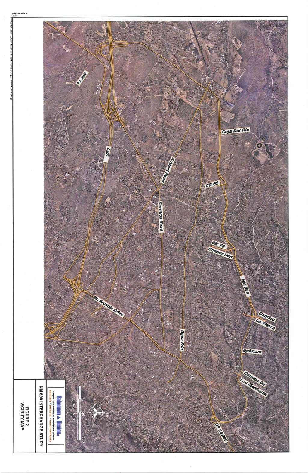
13 For the NM 599 Corridor April 2010 II. INTRODUCTION The NM 599 Corridor also referred to as the Santa Fe Bypass and the Veterans Memorial Highway, is located on the west and north sides of the City of Santa Fe beginning at NM 14 east of Interstate 25. The location map is shown in Figure 1. The corridor connects I-25 southwest of Santa Fe to US 84/285 North of Santa Fe as shown in Figure 2. The roadway facility serves as a North/South by-pass for vehicles traveling through Santa Fe and a WIPP route for low level nuclear waste traveling to the Waste Isolation Pilot Project near Carlsbad. As a high-speed limited access bypass through Santa Fe NM 599 provides local Santa Fe traffic an additional North South travel corridor and alleviates traffic congestion along Cerrillos Road and St. Francis Drive. However, there is public perception that improvements are needed to increase safety, particularly at intersections. Changes in regional traffic demand and issues related to the alignments of the intersections of other roads with NM 599 have also necessitated the need for additional analysis of the corridor in accordance with the New Mexico Department of Transportation (NMDOT) Location Study Procedures Manual. The study team for this corridor included representatives of the NMDOT, the City of Santa Fe, Santa Fe County, the Santa Fe Metropolitan Planning Organization, and the Federal Highway Administration. A Phase A Study for Initial Evaluation of Alternatives was completed in September All viable alternatives for meeting the needs in the corridor were identified. This study will perform a more detailed analysis of the alternatives and identify a preferred alternative in each location. This study has been coordinated with two concurrent studies conducted by the NMDOT: the Interstate 25 Corridor Study and the St. Francis Drive Corridor Study. I-25 (from NM 550 to Old Pecos Trail) is a high mobility interstate corridor with interchange connections accessing major arterial streets. St. Francis Drive (US 84/285) (from I-25 to NM 599) is one of the main north south urban arterials in Santa Fe, providing vehicular and pedestrian access to businesses and institutions, as well as accommodating through travel for north and south destinations. Each of these facilities provides different levels of transportation service and addresses different needs, but the three corridors also accommodate similar and overlapping travel demands. St. Francis Drive and NM 599 both serve north-south through travel. St. Francis provides greater accessibility to property, while NM 599 provides higher mobility. The Interstate 25 corridor provides interstate access to NM 599 and St. Francis Drive, but has the potential to interconnect with other major streets, which could influence the operation of both NM 599 and St. Francis Drive. The executive summaries of the I-25 Corridor Study and the St. Francis Drive Corridor Study can be found in Appendix A. P:\070064\Trans\Study\Report\NM599 Phase B_ docx 7
14
15
16 For the NM 599 Corridor April 2010 III. PURPOSE AND NEED A. Project Need Improvements to the NM 599 intersections that were planned but not constructed are being reevaluated. NM 599 was planned to be a future access controlled facility with interchanges at all locations except at NM 14 at the beginning of the route. The original environmental assessment, dated July 1987, identified three needs for the construction of NM 599 which should be considered in the re-evaluation: A north south relief route for through traffic traveling from I-25 to the communities north of Santa Fe on US 84/285. A WIPP route, carrying hazardous waste from Los Alamos National Laboratory to the Waste Isolation Pilot Project near Carlsbad. Congestion relief for the Santa Fe local street network. In addition to the original purpose and need, the current conditions were evaluated. The NMDOT Location Study Procedures Guidelines lists seven factors that can be the basis for the need of a transportation improvement. These factors are listed below along with their applicability to NM Physical Deficiencies No physical deficiencies have been identified for NM 599 with respect to the design speed of 65 miles per hour (mph) south of Airport Road and 60 mph from Airport Road through the Ridgetop Road Interchange. The horizontal and vertical curvature is adequate for the design speed. The bridges along the route are all in good condition. The lane and shoulder widths meet the recommendations of A Policy on Geometric Design of Highways and Streets by the American Association of State Highway and Transportation Officials for the design speed. One issue brought up by the public is that the existing 2 foot wide frontage road shoulders are inadequate for bicycles. The pavement will require maintenance based on its age but it is in good condition. Physical deficiencies do not contribute to project need. 2. Travel Demand and Congestion One of the original project needs for the construction of NM 599 was to relieve traffic congestion on the Santa Fe street system. The maintenance of NM 599 as a relief route should be considered when assessing projects. The existing roadway operates at a level of service of B during the peak hours indicating that there is no congestion on NM 599. Travel demand will increase as the area surrounding NM 599 continues to develop. Travel demand and congestion do not contribute to the need for a new project on NM 599. P:\070064\Trans\Study\Report\NM599 Phase B_ docx 10
17 For the NM 599 Corridor April Safety The crash rates on NM 599 for the period from 2003 through 2007 were below the statewide average. Fatal crashes on the roadway were all single car crashes mostly occurring at horizontal curves. The fatality rate in 2006 was much higher than the statewide rate because there were four fatalities in one crash. The lack of gaps in NM 599 traffic during the peak hours causes drivers to take risks to cross or access NM 599 which leads to a public concern about safety at the existing intersections. Addressing the safety concerns is a secondary need for the project. 4. System Connectivity NM 599 serves as a north south relief route for through traffic traveling from I-25 to the communities north of Santa Fe on US 84/285. NM 599 also serves as a WIPP route, carrying low level nuclear waste from Los Alamos National Laboratory to the Waste Isolation Pilot Project near Carlsbad. NM 599 was designed as an access controlled facility with interchanges. There are five interim at-grade intersections along the corridor where right-of-way has been preserved for a future interchange. Two additional access points at Jaguar Road and Caja del Rio have not been constructed. NM 599 is also used for local circulation, however, the unsignalized intersections are difficult to use during the peak hours. The frontage roads are discontinuous causing traffic to back track in order to reach their destinations. In addition, the local area roadway network is lacking in links between NM 599 and central Santa Fe which is a problem that must be addressed by local government. Maintaining NM 599 as a relief route is a primary need for the road and must be considered during any project analysis. 5. Access NM 599 is a limited access facility with 12 allowable access points. Thirteen access points were originally included but one was deleted after the public hearing. Two allowable access points at Jaguar Road and Caja del Rio have not been constructed. Access at the unsignalized intersections; CR 62, CR 70 Connection (Via Veteranos) and Camino de los Montoyas, is very poor with the level of service on the cross streets failing during the peak hours. Improved access to or across NM 599 is needed for local multimodal transportation on the north side of Santa Fe including vehicles, future transit, pedestrians and bicycles. Continued development along the corridor will require improved access to NM 599. Addressing the access issues is a primary need for a project on NM 599. P:\070064\Trans\Study\Report\NM599 Phase B_ docx 11
18 For the NM 599 Corridor April Economic Development This area of Santa Fe has many approved and proposed plans for the development of both housing and business. Tierra Contenta is an affordable housing development. This economic development is important to Santa Fe to provide the opportunity for Santa Fe s population to live and work in the community. Improved access to NM 599 would support this development by improving the flow of traffic onto and across NM599 from the local area. Addressing the transportation needs of economic development is a primary need for a project on NM Legislation There have been several legislative actions in response to access issues on NM 599. House Joint Memorial #6 from the Year nd special session requested that the New Mexico Department of Transportation (NMDOT), install traffic signals to provide safe crossings, ingress and egress to the bypass intersections with county roads 62 and 70 and with Camino de los Montoyas and Ephriam Street. The house memorial also requested the NMDOT, to work with federal and local highway agencies and local communities to improve the safety of the bypass and ensure that future connections are safe and that input and comments from the affected communities are addressed. In 2002, with House Bill 88, the New Mexico State Legislature appropriated money for planning and preliminary design of the Caja del Rio Road intersection with NM 599 in response to requests from the community and the development of multiple state and municipal facilities on Caja del Rio Road. The NMDOT initiated a location study of the intersection. The project was protested during the public meeting process because members of the public felt that another intersection on NM 599 should not be constructed until the existing intersections were improved. The project was dropped because the Santa Fe Metropolitan Planning Organization decided not to add it to the Transportation Improvement Program. NMDOT made a commitment to perform a study and a project prioritization for the entire corridor. This study is being completed in response to that NMDOT commitment. B. Statement of Purpose and Need NM 599 must continue to function as a relief route for the City of Santa Fe and as an alternative for hazardous waste transport from Los Alamos around the populated areas of Santa Fe. Improved access to or across NM 599 is needed for the all modes of travel as the area continues to develop. There is public perception that improvements are needed to address safety concerns, particularly at existing at-grade intersections. The purpose of the study is to develop a prioritization plan that addresses the access issues and supports economic development, regional transportation and long range planning goals. P:\070064\Trans\Study\Report\NM599 Phase B_ docx 12
19 For the NM 599 Corridor April 2010 Specific to each intersection location or segment of the corridor the following project purpose and need apply: An overpass is needed at the I-25 N. Frontage Road intersection to improve safety in the corridor and to provide improved access to the planned development on both sides of the corridor. The purpose of the overpass alternative is to meet the need of eventually making NM 599 from I-25 to US 84/285 an access controlled facility. Construction of the Jaguar Road Interchange is needed to provide direct access to or from Tierra Contenta from NM 599 and to remove traffic from Airport Road The purpose of the interchange is to provide improved access to Tierra Contenta, the Santa Fe Airport and to private development property on the west side of NM 599. Construction of the Airport Road Interchange is needed to improve the safety of the corridor at the highest crash location The purpose of the interchange is to eliminate an at-grade access point to achieve the goal of an access controlled facility. Construction of the Caja del Rio Interchange is needed to provide direct access to the public facilities on Caja del Rio. The purpose of the interchange is to provide improved access to Caja del Rio, to provide access to undeveloped property on the south side of NM 599, and to remove traffic from the CR 62 intersection. Construction of the CR 62 interchange is needed to improve the safety of the corridor, to improve access to and across NM 599 at an existing failing intersection, and to serve the increase in traffic that will occur with the South Meadows Extension. The purpose of the interchange is to provide improved access to the Agua Fria Community, the fire station, the medical center, the community park and to proposed development in the area and to eliminate an at-grade access point to achieve the goal of an access controlled facility. Construction of the CR 70 Connection (Via Veteranos) interchange is needed to improve access to and across NM 599 at an existing failing intersection and to serve the increase in traffic that will occur with the Siler Road Crossing. The purpose of the interchange is to provide improved access and to eliminate an at-grade access point to achieve the goal of an access controlled facility. Improvements at the Ephriam intersection are needed to provide access to proposed development in the area. The purpose of the improvement is to eliminate an at-grade access point to achieve the goal of an access controlled facility. Construction of improvements at the Camino de los Montoyas intersection is needed to improve access to and across NM 599 at an existing failing intersection. The purpose of the improvements is to provide better access to existing and proposed development in the area and to eliminate an at-grade access point to achieve the goal of an access controlled facility. P:\070064\Trans\Study\Report\NM599 Phase B_ docx 13
20 For the NM 599 Corridor April 2010 IV. PUBLIC INVOLVEMENT AND AGENCY COORDINATION A. Public Involvement During Phase A of the NM 599 Corridor Study there were two public open houses and a stakeholder s workshop. The public input from the Phase A study is contained in Appendix B. During Phase B of the study there were two public meetings that are described in the following paragraphs. 1. Public Open Houses and Public Information Meetings A public information meeting was held on October 6, 2009 at the Genoveva Chavez Community Center in Santa Fe to solicit public input on the Phase A Report and the viable alternatives identified. Approximately 60 members of the public, city, county, and state officials and project study team representatives were present. Prior to the meeting, the Phase A Report was posted on the Santa Fe MPO web site and copies were placed in the three libraries in Santa Fe. A public information meeting was held March 3, 2010 at the Genoveva Chavez Community Center in Santa Fe to solicit input on the preferred alternatives recommended by the Draft Phase B Detailed Evaluation of Alternatives and the Project Priority Plan. Approximately 48 people attended the meeting. The executive summary and preferred alternative figures were posted on the SF MPO Website prior to the meeting. Many of the comments at both meetings were clarifying the criteria used to evaluate and prioritize the interchanges. There were concerns regarding travel patterns, land use development plans, and safety. All input has been documented and considered as part of the Location Study Process. A summary of comments from the public is included in Appendix B. 2. Web Site A web site was used to keep the public informed. The web site was located on the NMDOT web site at and is listed on the site index. The web site contains general corridor information, a list of the study team, the management structure, project status, and a comment form. The Phase A Report for the corridor was posted on the Santa Fe MPO web site for review by the public prior to the October 6, 2009 stakeholder meeting. The executive summary and figures of the preferred alternatives from the Phase B Report were posted to the Santa Fe MPO web site prior to the March 3, 2010 public information meeting. B. Agency Coordination 1. Santa Fe MPO Committees The preferred alternatives were presented to the Santa Fe MPO Technical Coordinating Committee on December 7, 2009 and to the Transportation Policy Board on December 10, P:\070064\Trans\Study\Report\NM599 Phase B_ docx 14
21 For the NM 599 Corridor April 2010 The project priority plan was presented to the Technical Coordinating Committee on January 25, 2010 and to the Transportation Policy Board on February 11, V. TRAFFIC FORECASTS In order to create the traffic forecasts, the Future Forecast VISUM model maintained by the Santa Fe Metropolitan Planning Organization (MPO) was adjusted to create an NMDOT Base model. The MPO model includes S. Meadows Road from Agua Fria Street to the CR 62 / NM 599 Intersection and the Siler Road Extension from Agua Fria Street north to Alameda Street. The South Meadows Extension is in the Transportation Improvement Program. The Siler Road project will be substantially complete in July The model demographics reflect growth over the next 30 years or more, reflecting more of a build out of the modeled area. The Santa Fe MPO model was adjusted before the forecasting to create the NMDOT Base model which included the following: The Las Soleras socioeconomic data and roadway network from their VISUM runs. Las Soleras is an approved development located on the W. I-25 Frontage Road between Cerrillos Road and Richards Road. The Jaguar Interchange with NM 599. A developer is currently negotiating with the New Mexico Department of Transportation to design and construct the Jaguar Interchange using private funding. Four lanes on Richards Avenue from Avenida del Sur to Rodeo Road. The six scenarios that were modeled are described below: 1. Scenario 1 Full Regional System includes: on NM 599. Richards Interchange with Frontage Roads, Camino Carlos Rey Extension, Dinosaur Loop (West) Eldorado connection to College District All NM 599 access points as interchanges Auxiliary lanes on US 84/285 from NM 599 to Guadalupe I-25 Auxiliary Lanes and Interchange Improvements Includes Governor Miles extended to Rodeo Park with connections to Yucca and Galisteo Reduce speed limit on I-25 to 65 MPH Increase speed limit on NM 599 to 65 MPH Scenario 1 is the future full build out of all of the system improvements including all interchanges P:\070064\Trans\Study\Report\NM599 Phase B_ docx 15
22 For the NM 599 Corridor April Scenario 2 Intermediate Regional System includes: Same as Scenario 1 without the Richards Interchange Scenario 2 was run for the I-25 Corridor Study and will not be analyzed for impacts to NM Scenario 3 Near Term Regional System Improvements includes: I-25 Auxiliary Lanes and Interchange Improvements Eldorado connection to College District Auxiliary lanes on US 84/285 from NM 599 to Guadalupe Scenario 3 was run for the I-25 Corridor Study and will not be analyzed for impacts to NM Scenario 4 Auxiliary lanes I-25 and US 84/285 - Federal and State improvements only includes: I-25 Auxiliary Lanes and Interchange Improvements Auxiliary lanes on US 84/285 from NM 599 to Guadalupe All NM 599 at-grade access points and the Caja del Rio access point as signals Reduce speed limit on NM 599 to 45 mph No Eldorado connection to College District Scenario 4 included all signals on NM 599. Presumably all signals at the at-grade intersections will impact the ability of NM 599 to function as a bypass road for Santa Fe because of added delays introduced to NM 599 through traffic and as a result it would cause more traffic to use through streets in Santa Fe such as St. Francis Drive and Cerrillos Road. 5. Scenario 5 CR 62 and I-25 Frontage Road Interchanges The only improvements in Scenario 5 were interchanges on NM 599 at CR 62 and the I-25 Frontage Roads. The two interchange locations are far enough apart that they should not impact each other so they were able to be included in the same model run. 6. Scenario 6 Airport Road and CR 70 Interchange The only improvements in Scenario 6 were interchanges on NM 599 at Airport Road and the CR 70 Connection (Via Veteranos). Again the two interchange locations are far enough apart that they should not impact each other. Plots of the model output that will be used for this study analysis can be found in Appendix C. P:\070064\Trans\Study\Report\NM599 Phase B_ docx 16
23 For the NM 599 Corridor April 2010 VI. TRAFFIC ANALYSIS A. Warrant Analysis at Existing Unsignalized Intersection There are three existing unsignalized intersections in the NM 599 corridor. A signal warrant analysis was performed during the Phase A NM 599 Interchange Corridor Study Initial Evaluation of Alternatives. Based on criteria from the Manual on Uniform Traffic Control Devices, 2003 Edition, signals are warranted at County Road 62 in both the a.m. and p.m. peak hours and at CR 70 Connection (Via Veteranos) in the p.m. peak hour. Experience shows that intersection crash rates frequently increase with signal installation, although the crashes may be less severe. Signalization usually leads to a shift in crash types, with fewer angle and turning collisions and more rear-end collisions. B. System Impacts of Scenarios Scenarios 1 and 4 were compared to the DOT Base model to determine their overall impact to the system. The changes in traffic are summarized in Table 2 below. Table 2 Scenario 1 and 4 Impacts Location Scenario 1 Impact Scenario 4 Impact NM to 43% increase 4 to 40% decrease Northbound I-25 north of NM to 15% decrease 13 to 15% increase St. Francis Drive 5 to 7% decrease 5 to 10% increase Cerrillos Road north of I-25 2 to 5% decrease No significant change In Scenario 1, the scenario in which NM 599 intersection / access points are all interchanges and the corridor speed is increased to 65 mph, there is an increase in traffic on NM 599 of up to 43%, a decrease in traffic on northbound I-25 north of NM 599 of 7 to 15%, and a slight decrease on Cerrillos Road and St. Francis Drive away from NM 599 and I-25 of 2 to 7%. Scenario 4 is the scenario in which all of the existing at-grade intersections and a new at-grade intersection at Caja del Rio on NM 599 are signalized and the corridor speed limit is reduced to 45 mph. In this scenario there is a large decrease in traffic on NM 599 of up to 40%. The area of the largest decrease is between CR 62 and the CR 70 Connection (Via Veteranos). There is an increase in traffic on northbound I-25 north of NM 599 of up to 15%. There is an increase in traffic on St. Francis of 5% to 10%. There is no significant change on Cerrillos Road. The comparison of the traffic in Scenarios 1 and 4 shows that if NM 599 is going to function efficiently as a relief route for the City of Santa Fe then it needs to have interchanges instead of at-grade signalized intersections. P:\070064\Trans\Study\Report\NM599 Phase B_ docx 17
24 For the NM 599 Corridor April 2010 C. Weave Analysis Level of service for a weaving segment of a multilane highway is calculated as a density in passenger car per mile per lane. The delay for each level of service is shown in Table 3. Table 3 Level of Service Criteria for Weaving Segments Level of Service Delay for Multilane Weaving Segments A < 12.0 B > C > D > E > F >40.0 Concern was expressed during the public open houses and information meetings about the weave on NM 599 between the Ridgetop Road and US 84/285 Interchanges. A weaving analysis was completed for the northbound and southbound directions of NM 599 between the Ridgetop Rd interchange and the junction with US 84/285 using the DOT Base Model Traffic Forecasts and the Scenario 1 Traffic Forecasts. Northbound the ramp junctions are 1270 feet apart. In the northbound direction there is a standard weaving movement with a ramp entering and exiting on the right hand side. HICAP version 2 was used for the analysis. Southbound the ramp junctions are 1215 feet apart. The US 84/285 southbound on-ramp joins with the US 84/285 northbound on-ramp to form a two lane road. It was assumed for the purpose of this analysis that 2/3 of the traffic exiting at Ridgetop Road is coming from Santa Fe. This traffic must weave across the lane formed by the US 84/285 southbound on-ramp to exit at Ridgetop on the right hand side. This analysis was done by hand using the equations in the 2000 version of the Highway Capacity Manual. The traffic forecast model is calibrated to the PM Peak Hour so only the PM Peak was analyzed. The results of the analysis are shown in the following table. The calculations can be found in Appendix D. Ramp NB NM 599 Ridgetop Rd to US 84/285 SB NM 599 US 84/285 to Ridgetop Rd Table 4 Future Weave Capacity Analysis Results PM Peak DOT Base Volumes Delay LOS (pc/mi/ln) 13.4 B C PM Peak Scenario 1 Volumes Delay LOS (pc/mi/ln) 23.3 C 34.8 D The analysis shows that the weave operates at an acceptable level of service with the forecast volumes. It is recommended that the New Mexico Department of Transportation periodically reexamine this weave to determine if it remains at an acceptable level of service. P:\070064\Trans\Study\Report\NM599 Phase B_ docx 18
NM 599 Interchange Corridor Study December 2009
 II. INTRODUCTION The NM 599 Corridor also referred to as the Santa Fe Bypass and the Veterans Memorial Highway, is located on the south side of the City of Santa Fe beginning at NM 14 east of Interstate
PUBLIC INFORMATION MEETING TUESDAY MARCH 9, 2010
 St. Francis Drive Corridor Study Draft Phase B Review 1 PUBLIC INFORMATION MEETING TUESDAY MARCH 9, 2010 Objective Present Alternatives Evaluated Solicit Feedback On Selection of Recommended Projects 2
FOR INTERSTATE 81 AND ROUTE 37 INTERCHANGE FREDERICK COUNTY, VIRGINIA MILEPOST 310
 INTERCHANGE MODIFICATION REPORT FOR INTERSTATE 81 AND ROUTE 37 INTERCHANGE FREDERICK COUNTY, VIRGINIA MILEPOST 310 PREPARED BY: VIRGINIA DEPARTMENT OF TRANSPORTATION STAUNTON DISTRICT DECEMBER 13, 2006
Summary. Preliminary Alternative Development and Screening. DEIS July 23, 2018
 What is the Carolina Crossroads Project? The South Carolina Department of Transportation (SCDOT), in cooperation with the Federal Highway Administration (FHWA), is proposing to upgrade and redesign a key
VIII. LAND USE ISSUES
 VIII. LAND USE ISSUES The & Route 57 Land Use and Circulation Study (Land Use Study, Figure 6) was completed for the Town of Clay in November 1999 (Clough, Harbour & Associates). This study investigated
Bow Concord I-93 Improvements City of Concord Transportation Policy Advisory Committee
 Bow Concord I-93 Improvements City of Concord Transportation Policy Advisory Committee December 15, 2016 Agenda Project History / Project Development Process Traffic Modeling Alternatives Development o
INTERCHANGE MODIFICATION REPORT
 INTERSTATE 75 AND STATE ROAD 884 (COLONIAL BOULEVARD) INTERCHANGE LEE COUNTY, FLORIDA INTERCHANGE MODIFICATION REPORT Prepared for: Florida Department of Transportation District One May 2017 Interchange
I-69 Angelina and Nacogdoches Counties Scoping Study Executive Summary
 I-69 Angelina and Nacogdoches Counties Scoping Study Executive Summary November 2013 The Texas Department of Transportation (TxDOT) is working to find the most appropriate means to develop the Interstate
Community Advisory Committee Meeting No. 2. June 22, 2006
 Community Advisory Committee Meeting No. 2 June 22, 2006 Introductions The Study Team KDOT Wichita Partners Consultants CAC members Overview Today s Agenda Opinion Survey Study Status Starting Concept
I-35/80 Operations Study: Douglas Avenue to NW 86 th Street FOR
 : Douglas Avenue to NW 86 th Street FOR Iowa Department of Transportation City of Urbandale City of Grimes February 7, 2013 FINAL Prepared by: HR Green, Inc. HR Green Project Number: 40110031 TABLE OF
GUIDE FOR THE PREPARATION OF TRAFFIC IMPACT STUDIES
 GUIDE FOR THE PREPARATION OF TRAFFIC IMPACT STUDIES Adopted by Town Council on November 25, 2008 Prepared By: HNTB Engineering Department Planning Department TABLE OF CONTENTS I. INTRODUCTION... 1 II.
TRANSPORTATION PROJECT REPORT DRAFT CONCEPTUAL ACCESS MODIFICATION PROPOSAL OCTOBER 2002
 TRANSPORTATION INTERSTATE 87 INTERCHANGE 11A TOWN OF MALTA SARATOGA COUNTY, NY DRAFT CONCEPTUAL ACCESS MODIFICATION PROPOSAL OCTOBER 2002 PROJECT REPORT NEW YORK STATE DEPARTMENT OF TRANSPORTATION JOSEPH
DIVISION I TRAFFIC IMPACT STUDY GUIDELINES ENGINEERING STANDARDS
 CITY OF ALBANY DEPARTMENT OF PUBLIC WORKS DIVISION I TRAFFIC IMPACT STUDY GUIDELINES ENGINEERING STANDARDS Prepared By PUBLIC WORKS DEPARTMENT ALBANY, OREGON 97321 Telephone: (541) 917-7676 TABLE OF CONTENTS
St. Francis Drive through the City of Santa Fe Corridor Study
 VIII. ENGINEERING AND ENVIRONMENTAL EVALUATION INTERSECTION IMPROVEMENTS SOUTHERN For the southern end of the corridor, traffic volumes are expected to increase over existing levels. The Phase A Report
HIGHWAY 71 CORRIDOR IMPROVEMENT STUDY BELLA VISTA BYPASS MISSOURI STATE LINE BENTON COUNTY
 HIGHWAY 71 CORRIDOR IMPROVEMENT STUDY BELLA VISTA BYPASS MISSOURI STATE LINE BENTON COUNTY DRAFT December 2017 Highway 71 Corridor Improvement Study Bella Vista Bypass to Missouri State Line BENTON COUNTY
Military Highway Interchange
 III. Military Highway Interchange Deficiencies Design Challenges Proposed Alternatives III.1.2 Volumes & Operations Figure III.2: Existing Volumes displays the existing volumes for the Military Highway
2 Purpose and Need. 2.1 Study Area. I-81 Corridor Improvement Study Tier 1 Draft Environmental Impact Statement
 2 Purpose and Need 2.1 Study Area Interstate 81 (I-81) is relied upon for local and regional travel and interstate travel in the eastern United States. It extends 855 miles from Tennessee to New York at
Conceptual Design Report
 Conceptual Design Report I-244/Arkansas River Multimodal Bridge Tulsa, Oklahoma Prepared for the Oklahoma Department of Transportation Prepared by: August 2009 I-244 / ARKANSAS RIVER MULTIMODAL BRIDGE
The Folded Interchange: An Unconventional Design for the Reconstruction of Cloverleaf Interchanges
 The Folded Interchange: An Unconventional Design for the Reconstruction of Cloverleaf Interchanges I. ABSTRACT Keith A. Riniker, PE, PTOE This paper presents the Folded Interchange design and compares
LOCATION AND DESIGN DIVISION
 VIRGINIA DEPARTMENT OF TRANSPORTATION LOCATION AND DESIGN DIVISION INSTRUCTIONAL AND INFORMATIONAL MEMORANDUM GENERAL SUBJECT: Interstate, NHS Non-Interstate and Non-NHS (IJR / IMR Guidance) SPECIFIC SUBJECT:
APPENDIX B. Public Works and Development Engineering Services Division Guidelines for Traffic Impact Studies
 APPENDIX B Public Works and Development Engineering Services Division Guidelines for Traffic Impact Studies Revised December 7, 2010 via Resolution # 100991 Reformatted March 18, 2011 TABLE OF CONTENTS
I-10 CORRIDOR IMPROVEMENTS STAGE 0 FEASIBILITY STUDY STATE PROJECT NUMBER H FEDERAL AID PROJECT NUMBER H004100
 JULY 2016 I-10 CORRIDOR IMPROVEMENTS STAGE 0 FEASIBILITY STUDY STATE PROJECT NUMBER H.004100 FEDERAL AID PROJECT NUMBER H004100 EAST BATON ROUGE AND WEST BATON ROUGE PARISHES, LOUISIANA Section TABLE OF
Traffic Impact Study Guidelines. City of Guelph
 Traffic Impact Study Guidelines City of Guelph April 2016 Engineering and Capital Infrastructure Services Infrastructure, Development & Enterprise 1 Carden Street Guelph, Ontario Canada N1H 3A1 Page 1
I 75 PD&E STUDIES TABLE OF CONTENTS DTTM, TECHNICAL REPORT No. 2 TABLE OF CONTENTS
 TABLE OF CONTENTS DTTM, TECHNICAL REPORT No. 2 TABLE OF CONTENTS SECTION PAGE NO. SECTION TITLE NO. EXECUTIVE SUMMARY -------------------------------------------------------------------- ES-1 1.0 INTRODUCTION
2017 TIGER DISCRETIONARY GRANT APPLICATION
 2017 TIGER DISCRETIONARY GRANT APPLICATION Spokane International Airport Spokane, WA APPENDIX D 2015 Airport Drive Couplet at Spotted Road Airport Drive Couplet at Spotted Road April 2015 Prepared for:
EXECUTIVE SUMMARY. The IP developed the following purpose and need statement for the Part B I-71 Access Improvement Study.
 EXECUTIVE SUMMARY The Ohio-Kentucky-Indiana Regional Council of Governments (OKI) has conducted the with the following purpose: Develop a comprehensive transportation plan for the Uptown area that serves
MOBILITY AND ALTERNATIVES ANALYSIS
 6 MOBILITY AND ALTERNATIVES ANALYSIS BACK OF SECTION DIVIDER 6.0 Mobility and Alternatives Analysis Travel demand analysis provides a framework for the identification of transportation facilities and services
BCEO TRAFFIC IMPACT STUDY GUIDELINES
 BCEO TRAFFIC IMPACT STUDY GUIDELINES February 2006 TABLE OF CONTENTS INTRODUCTION..... i TRAFFIC IMPACT STUDY STRUCTURE... 1 WHEN IS A TRAFFIC IMPACT STUDY NEEDED?..... 1 STUDY AREA, SITE PLAN & HORIZON
DRAFT. SR-60 7 th Avenue Intersection Control Evaluation (ICE) I-605 Corridor Improvement Project (CIP) I-605/SR-60 EA# 3101U0
 I-605 Corridor Improvement Project (CIP) I-605/SR-60 EA# 3101U0") SR-60 7 th Avenue Intersection Control Evaluation (ICE) I-605/SR-60 EA# 3101U0 October 9, 2017 Contents 1 Purpose of ICE Memo... 1 2 Background... 1 3 Existing Interchange Deficiencies... 1 4 Context Sensitive
SR-60 7 th Avenue Intersection Control Evaluation (ICE) I-605/SR-60 EA# 3101U0 October 9, 2017 Contents 1 Purpose of ICE Memo... 1 2 Background... 1 3 Existing Interchange Deficiencies... 1 4 Context Sensitive
MEMORANDUM. Date: July 14, 2006 Project #: To: US 97 & US 20 Refinement Plan Steering Committee
 MEMORANDUM Date: July 14, 2006 Project #: 6389 To: US 97 & US 20 Refinement Plan Steering Committee From: Sonia Hennum, P.E., Andrew Cibor, E.I.T., & Julia Kuhn, P.E. Project: US 97 & US 20 Refinement
connections 2040 the waco metropolitan transportation plan amendment 1
 connections 2040 the waco metropolitan transportation plan amendment 1 developed by the waco metropolitan planning organization in cooperation with the following agencies: Adopted June 23, 2016 amendment
PROJECT STUDY REPORT. Cal Poly Pomona Senior Project
 06/2014 PROJECT STUDY REPORT (Cal Poly Pomona Senior Project) For Conceptual Approval of an Interchange Improvement And Cooperative Agreement with The City of Lake Elsinore for completion of Project Approval
GRE PID 80468
 Assessment of Feasible Alternatives Prepared for Ohio Department of Transportation 505 South SR 741 Lebanon, OH 45036-9518 December 2011 One Dayton Centre, Suite 1100 One South Main Street Dayton, OH 45402
Alternatives Identification and Evaluation
 I-290 Environmental Impact Statement West of Mannheim Road to East of Cicero Avenue Alternatives Identification and Evaluation May 2012 Draft Interim Report: Initial Alternatives Identification and Round
500 Interchange Design
 500 Interchange Design Table of Contents 501 Interchange Design... 5-1 July 2015 501.1 General... 5-1 501.2 Interchange Type... 5-1 501.2.1 General... 5-1 502 Interchange Design Considerations... 5-2 502.1
WOO-SR Feasibility Study (PID 90541) Feasibility Study Report April 22, 2011
 Feasibility Study Report April 22, 2011") TABLE OF CONTENTS EXECUTIVE SUMMARY... 1 CHAPTER 1: INTRODUCTION... 5 1.1 Study Purpose and background... 5 1.2 Study Approach... 6 1.3 Study Area... 6 CHAPTER 2: DESCRIPTIONS OF ALTERNATIVES... 7 2.1
TABLE OF CONTENTS EXECUTIVE SUMMARY... 1 CHAPTER 1: INTRODUCTION... 5 1.1 Study Purpose and background... 5 1.2 Study Approach... 6 1.3 Study Area... 6 CHAPTER 2: DESCRIPTIONS OF ALTERNATIVES... 7 2.1
An Introduction to the. Safety Manual
 An Introduction to the Highway Safety Manual An Introduction to the HIGHWAY SAFETY MANUAL Table of Contents Section 1: HSM Overview... 1 What is the Highway Safety Manual?... 1 How is the HSM Applied?...
M D 355 [FR E D E R IC K R O A D] OVER
![M D 355 [FR E D E R IC K R O A D] OVER](/thumbs/79/79553721.jpg "M D 355 [FR E D E R IC K R O A D] OVER") M D 355 [FR E D E R IC K R O A D] OVER LITTLE BENNETT CREEK MAINTENANCE OF TRAFFIC ALTERNATIVE ANA LYSIS Prepared by: INTRODUCTION The purpose of this report is to present the results of traffic analyses
M D 355 [FR E D E R IC K R O A D] OVER LITTLE BENNETT CREEK MAINTENANCE OF TRAFFIC ALTERNATIVE ANA LYSIS Prepared by: INTRODUCTION The purpose of this report is to present the results of traffic analyses
Exit 73 I-29 Interchange Modification Justification Study
 xit 73 I-29 Interchange Modification Justification tudy Introduction Figure 1 shows the location of xit 73. This interchange is proposed to be the connecting point of the ast and West Corridors to I-29.
04 ALA /6.7. Vicinity Map
 04 ALA 80 6.5/6.7 04 ALA 80 6.5/6.7 Vicinity Map Note: I-80 is designated as an east-west freeway. Gilman Street is referred to as a northsouth urban arterial for the remainder of the report. 04 ALA 80
Project Prioritization for Urban and Rural Projects TEAM CONFERENCE March 7, 2018
 Project Prioritization for Urban and Rural Projects 2018 TEAM CONFERENCE March 7, 2018 Challenge Limited funding for transportation improvements requires strategic selection of projects to ensure resource
TRAFFIC STUDY GUIDELINES
 TRAFFIC STUDY GUIDELINES December 2013 The scope of the traffic impact analysis (TIA) should follow these guidelines and the requirements of VMC 11.80.130 and VMC 11.70, transportation concurrency (attached
CITY OF MARIANNA MUNICIPAL DEVELOPMENT DEPARTMENT Post Office Box 936 Marianna, FL (850)
") CITY OF MARIANNA MUNICIPAL DEVELOPMENT DEPARTMENT Post Office Box 936 Marianna, FL 32447 (850) 482-2786 TRANSPORTATION CONCURRENCY ANALYSIS CITY OF MARIANNA CONCURRENCY MANAGEMENT SYSTEM (CMS) This form
CITY OF MARIANNA MUNICIPAL DEVELOPMENT DEPARTMENT Post Office Box 936 Marianna, FL 32447 (850) 482-2786 TRANSPORTATION CONCURRENCY ANALYSIS CITY OF MARIANNA CONCURRENCY MANAGEMENT SYSTEM (CMS) This form
500 Interchange Design
 500 Interchange Design Table of Contents 501 Interchange Design... 1 501.1 General... 1 501.2 Interchange Type... 1 501.2.1 General... 1 502 Interchange Design Considerations... 2 502.1 Determination of
TABLE OF CONTENTS TABLE OF CONTENTS... I APPENDICES... III LIST OF EXHIBITS... V LIST OF TABLES... VII LIST OF ABBREVIATED TERMS...
 Amendment No. 2 to Reclamation Plan 2006-01 Traffic Impact Analysis TABLE OF CONTENTS TABLE OF CONTENTS... I APPENDICES... III LIST OF EXHIBITS... V LIST OF TABLES... VII LIST OF ABBREVIATED TERMS... IX
CHAPTER 8: I-71 ACCESS IMPROVEMNETS
 CHAPTER 8: I-71 ACCESS IMPROVEMNETS I-71 Access Improvements were a separate and distinct part of the overall Uptown Transportation Study. This Part B work is fully documented in the Planning Study Report
CHAPTER 5 PARALLEL PARKWAY CORRIDOR IMPROVEMENTS
 HPTER 5 PRLLEL PRKWY ORRIDOR IMPROVEMENTS nother key area within the Village West study area is the Parallel Parkway corridor. This chapter focuses on the segment of Parallel Parkway between 106 th Street
Engineering Design Services for Safety Improvements along CR 476 from the Hernando County Line to US 301 (SR 35) Sumter County, Florida
 Sumter County, Florida") Engineering Design Services for Safety Improvements along CR 476 from the Hernando County Line to US 301 (SR 35) Sumter County, Florida November 7, 2014 SUBMITTED BY: Dewberry Bowyer-Singleton 520 South
Engineering Design Services for Safety Improvements along CR 476 from the Hernando County Line to US 301 (SR 35) Sumter County, Florida November 7, 2014 SUBMITTED BY: Dewberry Bowyer-Singleton 520 South
CHAPTER 4 GRADE SEPARATIONS AND INTERCHANGES
 CHAPTER 4 GRADE SEPARATIONS AND INTERCHANGES 4.0 INTRODUCTION The ability to accommodate high volumes of intersecting traffic safely and efficiently through the arrangement of one or more interconnecting
DDI s Can Move More Than Cars. Alex Ariniello. Presentation for the ITE Western District Annual Meeting. July, 2016 in Albuquerque, New Mexico
 DDI s Can Move More Than Cars Alex Ariniello Presentation for the ITE Western District Annual Meeting July, 2016 in Albuquerque, New Mexico In January, 2016, a Diverging Diamond Interchange (DDI) opened
I 95 EXPRESS LANES SOUTHERN TERMINUS EXTENSION TRAFFIC OPERATIONS AND SAFETY ANALYSIS REPORT
 I 95 EXPRESS LANES SOUTHERN TERMINUS EXTENSION TRAFFIC OPERATIONS AND SAFETY ANALYSIS REPORT February 2016 INTERSTATE 95 EXPRESS LANES SOUTHERN TERMINUS EXTENSION PROJECT Commonwealth of Virginia Virginia
Environmental Consequences and Mitigation
 Chapter 4 Environmental Consequences and Mitigation 4.1 Introduction This chapter provides a detailed description of the impacts (and indirect impacts where applicable) associated with the alternatives
Introduction. Performance Measurement. Pg. 01
 Pg. 01 Introduction The Alamo Area recognizes the importance of transportation performance tracking, goal setting and measurement to provide greater accountability and transparency and to achieve a more
The TIS is to be signed and sealed by a Florida Registered Professional Engineer.
 CHAPTER 900. SECTION 901. DEVELOPMENT STANDARDS INFRASTRUCTURE STANDARDS 901.5. Transportation Impact Study A. Intent and Purpose The intent and purpose of the Traffic Impact Study (TIS) is to identify
FLORIDA DEPARTMENT OF TRANSPORTATION Planning and Environmental Management Office INTERCHANGE MODIFICATION REPORT
 FLORIDA DEPARTMENT OF TRANSPORTATION Planning and Environmental Management Office INTERCHANGE MODIFICATION REPORT District 2 1109 South Marion Avenue Lake City, FL 32025-5874 INTERSTATE 10 (SR 8) / SR
THE PROJECT. Executive Summary. City of Industry. City of Diamond Bar. 57/60 Confluence.
 THE PROJECT A freeway segment ranked 6th worst in the Nation, with levels of congestion, pollution and accidents that are simply unacceptable and which have Statewide and National implications. Executive
Final Air Quality Report
 Florida Department of Transportation - District VII County Line Road (C.R. 578) Project Development and Environment Study From U.S. 19 (S.R. 55) to U.S. 41 (S.R. 45) Work Program Item Segment Number: 257298
Route 7 Connector Ramp MODIF IE D I N T ER C H A N G E M OD IFICATIO N R E PO RT TRA N S F O R M I : I N S ID E THE BE LTWAY
 STATE PROJECT NUMBER: 0066-96A-493,P101, C501, B686; UPC: 110629 FEDERAL PROJECT NUMBER: NHPP-066-1(356) FAIRFAX COUNTY, VIRGINIA TRA N S F O R M I - 6 6 : I N S ID E THE BE LTWAY Route 7 Connector Ramp
MEMORANDUM: INITIAL CONCEPTS SUMMARY
 MEMORANDUM: INITIAL CONCEPTS SUMMARY INTRODUCTION This memo presents a summary of initial concepts that have been identified as development of the project study has progressed, along with a recommendations
Transportation Improvement Program (TIP) Relationship to 2040 Metropolitan Transportation Plan (MTP) - Goals and Performance Measures
 Relationship to 2040 Metropolitan Transportation Plan (MTP) - Goals and Performance Measures") Mid-Region Metropolitan Planning Organization Mid-Region Council of Governments 809 Copper Avenue NW Albuquerque, New Mexico 87102 (505) 247-1750-tel. (505) 247-1753-fax www.mrcog-nm.gov Transportation
Mid-Region Metropolitan Planning Organization Mid-Region Council of Governments 809 Copper Avenue NW Albuquerque, New Mexico 87102 (505) 247-1750-tel. (505) 247-1753-fax www.mrcog-nm.gov Transportation
WELCOME COMMUNITY ADVISORY GROUP MEETING #2
 WELCOME COMMUNITY ADVISORY GROUP MEETING #2 Joliet Junior College OUTLINE / AGENDA Recap of CAG #1 Presentation Recap of CAG #1 Workshop Context Audit / Survey Results Draft Problem Statement Draft Purpose
Future Build Alternative Traffic Forecasts and Level of Service Analysis
 4.2.10 Future Build Alternative Traffic Forecasts and Level of Service Analysis For the five Build Alternatives, study intersections within one mile of potential station locations were analyzed, as it
IH 30/IH 35E Reconstruction Project Pegasus Final Technical Memorandum - Evaluation of Conceptual Alternatives Task 7.5
 MEMO TO: Timothy Nesbitt, P.E. DATE: August 26, 2002 FROM: SUBJECT: Sandy Wesch-Schulze, P.E., AICP IH 30/IH 35E Reconstruction Project Pegasus Final Technical Memorandum - Evaluation of Conceptual Alternatives
NW La Center Road/I-5 Interchange Improvement Project (MP 16.80)
") FINAL DRAFT - NW La Center Road/I-5 Interchange Improvement Project (MP 16.80) La Center, Washington February 2015 FINAL DRAFT - NW La Center Road/I-5 Interchange Improvement Project (MP 16.80) La Center,
FINAL DRAFT - NW La Center Road/I-5 Interchange Improvement Project (MP 16.80) La Center, Washington February 2015 FINAL DRAFT - NW La Center Road/I-5 Interchange Improvement Project (MP 16.80) La Center,
Appendix B. Benefit-Cost Technical Memorandum
 Appendix B Benefit-Cost Technical Memorandum This Page Left Blank Intentionally MEMORANDUM TO: FROM: Michael Kalnbach MnDOT District 1 Project Manager Graham Johnson, PE DATE: September 2, 2014 RE: TH
DEVELOPMENT, ANALYSIS, AND DESIGN OF A NEW PARKWAY AT GRADE INTERSECTION (PAGI)
") 2013 ITE Western District Annual Meeting COCEPT DEVELOPMET, AALYSIS, AD DESIG OF A EW PARKWAY AT GRADE ITERSECTIO (PAGI) Lead Author: James M. Witkowski, PhD Supporting Author: Darrell Truitt, PE The Pima
2013 ITE Western District Annual Meeting COCEPT DEVELOPMET, AALYSIS, AD DESIG OF A EW PARKWAY AT GRADE ITERSECTIO (PAGI) Lead Author: James M. Witkowski, PhD Supporting Author: Darrell Truitt, PE The Pima
PROPOSED AMENDMENT OF THE I 76 INTEGRATED CORRIDOR MANAGEMENT PROJECT TO THE CONNECTIONS 2040 PLAN FOR GREATER PHILADELPHIA
 PROPOSED AMENDMENT OF THE I 76 INTEGRATED CORRIDOR MANAGEMENT PROJECT TO THE CONNECTIONS 2040 PLAN FOR GREATER PHILADELPHIA Background and Project Description In July 2013, the Delaware Valley Regional
Beltline Interchange Range of Alternatives Screening Summary Memo
 Range of Alternatives Screening Summary Memo (Concurrence Point #2 from the Agency Coordination Plan) (I-39/90 and US 12/18 Interchange) Dane County, Wisconsin WisDOT Project ID 1007-10-02 Table of Contents
City of Menifee. Public Works Department. Traffic Impact Analysis Guidelines
 Public Works Department Traffic Impact Analysis Guidelines Revised: August 2015 TABLE OF CONTENTS INTRODUCTION... 3 PURPOSE... 3 EXEMPTIONS... 3 SCOPING... 4 METHODOLOGY... 5 STUDY AREA... 6 STUDY SCENARIOS...
Peterborough County Road Safety Audit Guideline Pilot
 Peterborough County Pilot Table of Contents 1.0 Purpose... 3 2.0 Road Safety Audit Objectives... 3 3.0 Legal Issues... 3 4.0 Road Safety Audit Procedures... 4 4.1 Project Selection Criteria... 5 4.2 Scope...
Traffic Impact Study Requirements
 [TYPE THE COMPANY NAME] Traffic Impact Study Requirements County of San Mateo Department of Public Works Roadway Services 9/1/2013 I. Introduction The County of San Mateo (County), Department of Public
Woodburn Interchange Project Transportation Technical Report
 Final Report Woodburn Interchange Project Transportation Technical Report Prepared for Oregon Department of Transportation April 212 Prepared by DKS Associates Contents Methodologies... 4 Volume Development...
vi Figures viii Summary S.1
 Contents Contents iii Tables vi Figures viii Summary S.1 Chapter 1: Purpose and Need Project History A.1 Project Description A.2 Project Purpose A.5 Transportation Need A.6 Highway Capacity and Congestion
Chapter 2 Transportation Element Goals, Objectives and Policies
 Chapter 2 Transportation Element Goals, Objectives and Policies City of Belleview Comprehensive Plan Adopted by Ord 2016-10 on July 5, 2016 GOALS, OBJECTIVES AND POLICIES Goal 2 Transportation...1 Objective
Consideration of a Diverging Diamond Interchange in Saskatchewan. Paul H. A. Steel, Project Manager, M. Eng., P.Eng., Tetra Tech EBA Inc.
 Consideration of a Diverging Diamond Interchange in Saskatchewan Paul H. A. Steel, Project Manager, M. Eng., P.Eng., Tetra Tech EBA Inc. Terry Schmidt, P.Eng., MBA, Senior Project Director, Tetra Tech
Vicinity Map. Interstate 605 (I-605) and State Route 91 (SR-91) in Los Angeles County
 and State Route 91 (SR-91) in Los Angeles County") 07 - LA - 605 - PM 2.87/PM 6.36 07 - LA - 91 - PM 14.10/PM 19.81 Vicinity Map N On Routes Interstate 605 (I-605) and State Route 91 (SR-91) in Los Angeles County I-605 between Excelsior Dr UC (PM 6.36)
07 - LA - 605 - PM 2.87/PM 6.36 07 - LA - 91 - PM 14.10/PM 19.81 Vicinity Map N On Routes Interstate 605 (I-605) and State Route 91 (SR-91) in Los Angeles County I-605 between Excelsior Dr UC (PM 6.36)
The Secrets to HCM Consistency Using Simulation Models
 The Secrets to HCM Consistency Using Simulation Models Ronald T. Milam, AICP David Stanek, PE Chris Breiland Fehr & Peers 2990 Lava Ridge Court, Suite 200 Roseville, CA 95661 r.milam@fehrandpeers.com (916)
New Mexico Statewide Model
 New Mexico Statewide Model Fifth Largest State in land area 2005 Population 1.97 million 42% of state in Albuquerque and Santa Fe area Outside urban areas population density very low New Mexico Planning
TOWN OF MOORESVILLE TRANSPORTATION IMPACT ANALYSIS PROCEDURES MANUAL TOWN OF MOORESVILLE, NORTH CAROLINA
 TOWN OF MOORESVILLE TRANSPORTATION IMPACT ANALYSIS PROCEDURES MANUAL TOWN OF MOORESVILLE, NORTH CAROLINA Effective August 1, 2007 Amended March 4, 2013, December 1, 2014, May 1, 2017 TOWN OF MOORESVILLE,
2. Alternatives ENVIRONMENTAL ASSESSMENT US 52 OPERATIONAL IMPROVEMENTS. 2.1 Introduction
 2. Alternatives 2.1 Introduction This chapter discusses the development and evaluation of scenarios and alternatives considered for the proposed action. The goal of this process, which is described in
Appendix D: Functional Classification Criteria and Characteristics, and MnDOT Access Guidance
 APPENDICES Appendix D: Functional Classification Criteria and Characteristics, and MnDOT Access Guidance D.1 Functional classification identifies the role a highway or street plays in the transportation
South Dakota Interstate Corridor Study. Phase I Summary Report
 South Dakota Interstate Corridor Study Phase I Summary Report December 2000 Prepared for: South Dakota Department of Transportation 700 East Broadway Avenue Pierre, South Dakota 57501-2586 Prepared by:
Traffic Impact Analysis Guidelines. Town of Queen Creek
 Traffic Impact Analysis Guidelines Town of Queen Creek January 2016 1. INTRODUCTION The purpose of this document is to outline the procedures and requirements for preparing a Transportation Impact Analysis
RESOLUTION NO
 RESOLUTION NO. 2018-12 RESOLUTION OF THE SOUTHEASTERN WISCONSIN REGIONAL PLANNING COMMISSION AMENDING THE TRANSPORTATION IMPROVEMENT PROGRAM FOR SOUTHEASTERN WISCONSIN: 2017-2020 WHEREAS, the Southeastern
Livability 2050 Regional Transportation Plan Update. Transportation Policy Board (TPB) August 23, 2018
 August 23, 2018") Livability 2050 Regional Transportation Plan Update Transportation Policy Board (TPB) August 23, 2018 1 Oct. 2017 Plan Kick-Off Sept. 2019 Plan Adoption Timeline Livability 2050 Regional Transportation
Livability 2050 Regional Transportation Plan Update Transportation Policy Board (TPB) August 23, 2018 1 Oct. 2017 Plan Kick-Off Sept. 2019 Plan Adoption Timeline Livability 2050 Regional Transportation
Final Recommendations Identification of Improvements, Strategies, and Solutions
 Identification of Improvements, Strategies, and Solutions Prepared by: December 2015 TABLE OF CONTENTS 1. Introduction... 1 1 2. Freight Policy Recommendations... 2 1 3. Freight Infrastructure Recommendations...
2040 Transportation Policy Plan Conversion to Performance Based Planning Basis. 25 th Annual CTS Transportation Research Conference May 21, 2014
 2040 Transportation Policy Plan Conversion to Performance Based Planning Basis 25 th Annual CTS Transportation Research Conference May 21, 2014 1 About the plan Long-range transportation plan for the Twin
CITY OF VALLEJO PUBLIC WORKS DEPARTMENT TRAFFIC IMPACT Analysis/Study GUIDELINES
 The City Engineer, under the authority of the Public Works Director and recommendations from the Traffic Engineer, will make the final decision on the need for a traffic study. The purpose of the traffic
TRAFFIC SAFETY EVALUATION. Using the Highway Safety Manual and the Interactive Highway Safety Design Model. I 15 Dry Lakes Design Exception
 TRAFFIC SAFETY EVALUATION Using the Highway Safety Manual and the Interactive Highway Safety Design Model I 15 Dry Lakes Design Exception Prepared for: Nevada Department of Transportation Safety Engineering
I-270 NORTH EA PERFORMANCE MEASURES IN NEPA
 I-270 NORTH EA PERFORMANCE MEASURES IN NEPA Buddy Desai, PE CH2M St. Louis THE ISSUE US State Departments of Transportation continue to struggle with addressing current and emerging problems with increasingly
CHAPTER 2: MODELING METHODOLOGY
 CHAPTER 2: MODELING METHODOLOGY 2.1 PROCESS OVERVIEW The methodology used to forecast future conditions consisted of traditional traffic engineering practices and tools with enhancements to more accurately
Highway and Freight Current Investment Direction and Plan. TAB September 20, 2017
 Highway and Freight Current Investment Direction and Plan TAB September 20, 2017 Today s Topics Where are we now, what are the current issues? Where do we want to go? How will we get there? What are the
Adaptation of HERS-ST Models for the South Carolina Interactive Interstate Management System
 Adaptation of HERS-ST Models for the South Carolina Interactive Interstate Management System presented to the Transportation Research Board HERS Modeling and Data Integration Conference presented by William
EXECUTIVE SUMMARY. 1. Introduction
 EXECUTIVE SUMMARY 1. Introduction A safety review of the Highway 2:15 (Deerfoot Trail) corridor was commissioned by Alberta Transportation in conjunction with the City of Calgary (City). The review was
A three-stage process was implemented in order to develop and evaluate the project concepts and provide recommendations for the project.
 MEMORANDUM TO: FROM: Highway 36/Rice Street PMT Mark Benson DATE: March 23, 2009 RE: Selection of a Preferred Alternative SEH No. 105803 The purpose of this memorandum is to document the process for selecting
Transportation Connectivity, Accessibility and Economic Opportunity Study
 COMMERCE CORRIDOR Transportation Connectivity, Accessibility and Economic Opportunity Study Richmond Regional Transportation Planning Organization Citizens Transportation Advisory Committee 9/15/2016 Photo:
FINAL REPORT GUIDELINES FOR PRELIMINARY SELECTION OF THE OPTIMUM INTERCHANGE TYPE FOR A SPECIFIC LOCATION
 FINAL REPORT GUIDELINES FOR PRELIMINARY SELECTION OF THE OPTIMUM INTERCHANGE TYPE FOR A SPECIFIC LOCATION Nicholas J. Garber, Ph.D. Faculty Research Scientist and Professor of Civil Engineering Michael
12 Evaluation of Alternatives
 12 Evaluation of Alternatives This chapter evaluates the effectiveness of the No-Build Alternative and the proposed METRO Blue Line Light Rail Transit (BLRT) Extension project based on the information
6.0 CONGESTION HOT SPOT PROBLEM AND IMPROVEMENT TRAVEL DEMAND MODEL ANALYSIS
 6.0 CONGESTION HOT SPOT PROBLEM AND IMPROVEMENT TRAVEL DEMAND MODEL ANALYSIS 6.1 MODEL RUN SUMMARY NOTEBOOK The Model Run Summary Notebook (under separate cover) provides documentation of the multiple
Welcome. Public Meeting. August 2, :00 to 7:00 p.m. Presentation 6:00 to 6:30 p.m.
 Welcome Public Meeting August 2, 2017 5:00 to 7:00 p.m. Presentation 6:00 to 6:30 p.m. www.glenwoodsouthbridge.net Welcome to the South Bridge Environmental Assessment Public Meeting Why Are We Here Tonight?