WATERSHED MANAGEMENT IN MINNESOTA. GOVERNANCE, PLANNING, AND FUNDING June 19, 2018 Cedar Rapids, Iowa
|
|
|
- Sharlene Cain
- 5 years ago
- Views:
Transcription

1 WATERSHED MANAGEMENT IN MINNESOTA GOVERNANCE, PLANNING, AND FUNDING June 19, 2018 Cedar Rapids, Iowa
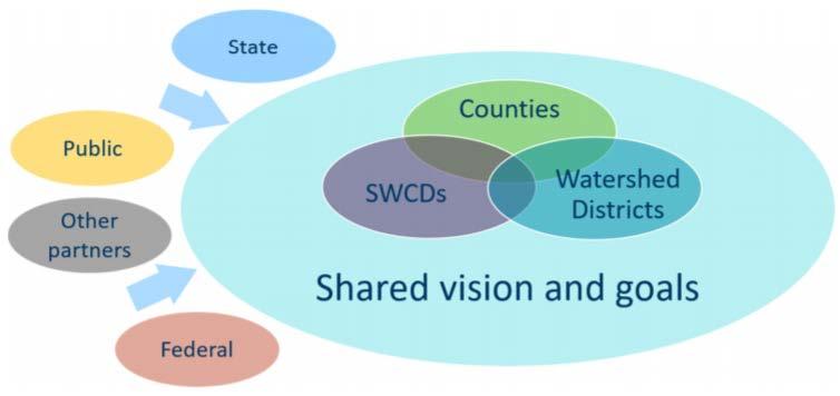
2 GOVERNANCE - WD 1955 Watershed Act (MN Statute 103D) Local petition to form VOLUNTARY watershed district Comes with rule making and taxing authorities Board members are appointed by elected county officials


3 Watershed Size Smallest = 43 sq. mi. Largest = 5990 sq. mi.
4 GOVERNANCE - WMO 1982 Metropolitan Surface Water Management Act MN Statute 103B MANDATORY membership in a watershed management organization throughout 7-county metro area Board members are appointed by cities, townships

5 Metro Watershed Management Option 1. Form a WD Option 2. Joint Powers Agreement Option 3. Manage through county government

6 RULES Adopt rules to regulate the use of water resources CONTRACTS Contract with gov t & private/public corporations ACTIVITIES STAFF LEVY / TAX Hire staff and contract with consultants Assess properties for benefits received and levy taxes to finance district administration CONSTRUCT Acquire, construct, and operate drainage systems, dams, dikes, reservoirs, and water supply systems GRANTS Accept grant funds, encumber debt
7 PLANNING

8 10 MOA PARTNERS Area II Minnesota River Basin Projects Lac qui Parle County Lac qui Parle SWCD Lincoln County Lincoln SWCD Lyon County Lyon SWCD Yellow Medicine County Yellow Medicine SWCD Yellow Medicine River Watershed District

9 PLANNING


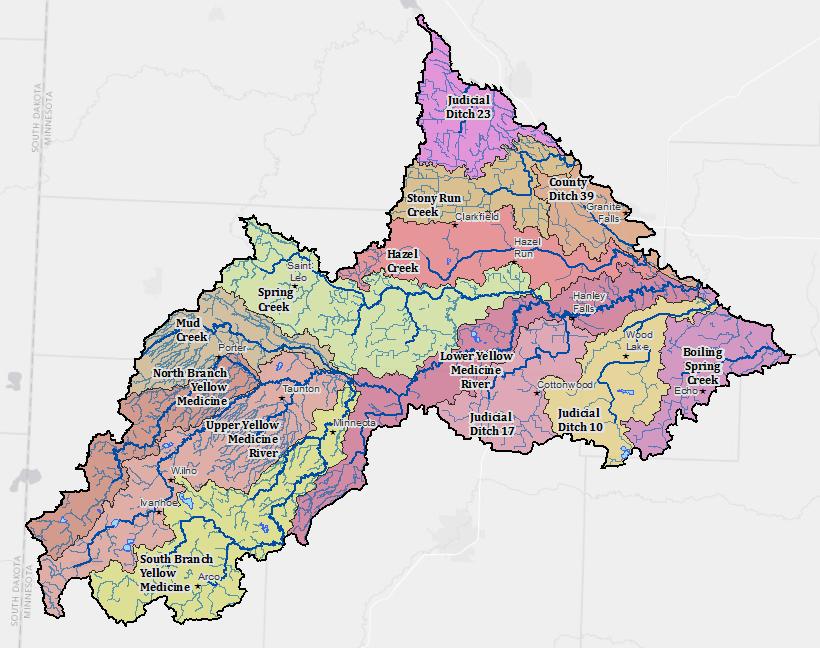
10 TOPOGRAPHY TOTAL DROP = 1125 ~ 57 feet/mile 665,073 acres (1,039 sq. mi.) 1,740 miles of streams/ditches 16,000 acres of shallow lakes 15,000 humans 150,000 feedlot animals units ~ 5 feet/mile ~ 45 feet/mile ~ 20 feet/mile

11 PUBLIC WATERS

12 IMPAIRMENTS IMPAIRED WATERS


13 Wetland Loss = 76% WATERSHED STATS Pasture, Hay, Grassland 9% Cultivated Crops 79% Developed Open Space 5% Wetlands 4% Open Water / Deciduous Forest 3%


14 PRIORITY CONCERNS Identify and Rank Issues
 losses due to bank erosion (ditch and stream) 4.")
15 PRIORITY 1 Mitigate ALTERED HYDROLOGY, Reduce FLOODING Reduction in flood storage due to agricultural drainage 22.1 Reduced productivity due to declining SOIL HEALTH 11.6 Reduction in habitat areas due to loss of wetlands 5.0 Infrastructure losses due to flooding 4.6 Crop (and land) losses due to bank erosion (ditch and stream) 4.1 Insufficient capacity to efficiently carry runoff/flood volumes 2.9 Unsuitable habitat due to creeks running dry 1.8 TOTAL = 52.0
 4.6 Decreased recreational opportunities due to excess nutrients 3.")
16 PRIORITY 2 Reduce POLLUTANT TRANSPORT Reduced productivity due to SOIL EROSION by runoff and/or wind 16.2 Unsuitable habitat due to turbid water (muddy, nutrient rich) 4.6 Decreased recreational opportunities due to excess nutrients 3.2 Decreased recreation due to unsafe levels of bacteria, pesticides 2.9 TOTAL = 26.8

17 PRIORITY 3 Preserve and protect GROUNDWATER Groundwater depletion due to overuse and altered hydrology 5.7 Groundwater contamination 4.8 TOTAL = 10.5

18 MISCELLANEOUS CONCERNS Declining high quality habitat areas for diverse wildlife 3.1 Excess vegetation in lakes 1.6 Crop losses related to blockages in drainage system 1.5 Losses of various type of terrain 1.2 Decreased habitat diversity due to invasive species 1.1 Overgrazing 0.8 Decreased recreational opportunities due to parasites in the water 0.5 Decreased fish consumption due to unsafe levels of mercury in fish 0.3 Lack of crop diversity 0.3 TOTAL = 10.4


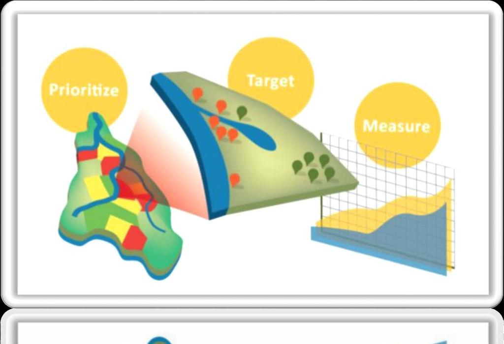
19 TARGETED AREAS WHERE DO WE START?

20
21 MEASURABLE GOALS Stressor Altered Hydrology Excess Phosphorus Excess Nitrogen Excess Sediment WRAPS Fully Restored Watershed Goal 20% reduction in annual river flow volume 35% reduction in river loads 25% reduction in river loads 20% reduction in river loads WRAPS 10-year Goal 5% reduction 10% reduction 10% reduction 8% reduction
22 IMPLEMENTATION PLAN Yellow Medicine One Watershed One Plan Implementation Plan for Priority Areas Pollutant Transport Field Practice Wetland Restorations Water/Sediment Basins Controlled Drainage Cover Crops Reduced Tillage Nutrient Management Buffers Row Crop Grassland Alternative Tile Intakes Scale of Treatment Treats 2.0% of cropland Treats 2.5% of cropland Implemented on 1% of cropland Add to 20% of corn/soybean land 30% residue on 10% of cropland Adopt U of M standards on 35% of land Gain compliance with the buffer law Convert 2% of highly erodible land Replace open inlets on 2% of land


23 FUNDING Bonding Administrative Levy Project Levy Technology Levy Taxing Authorities 3/8 Services/Fees Permit Fees Inspections Grants Contributions Federal Grants State Cost Share Clean Water Fund 1W1P Grants SWCD Capacity Grants Landowners Non-Profits
24 THANK YOU! EMILY JAVENS, EXECUTIVE DIRECTOR MN ASSOCIATION OF WATERSHED DISTRICTS
How is Water Quality Affected by Land Use?
 Watershed Connections Lesson Les4 3 How is Water Quality Affected by Land Use? Overview What are the benefits of a healthy watershed? What are examples of land uses? What types of pollution can come from
BWSR PROGRAMS THAT ADDRESS NUTRIENT LOSS
 BWSR PROGRAMS THAT ADDRESS NUTRIENT LOSS DRAINAGE LAW BUFFER PROGRAM CREP - GRANT PROGRAMS - PROJECTS 2017 MVTL Agronomy Update Meeting New Ulm, MN February 28, 2017 Jill Sackett Eberhart ~ BWSR Board
Shell Rock River Watershed: Water Plans
 Shell Rock River Watershed: Water Plans The Shell Rock River Watershed encompasses Freeborn County. Each county has developed a 10-year rotating comprehensive local water management plan (LWMP) in order
Agricultural/Rural Riparian Buffer Analysis
 Agricultural/Rural Riparian Buffer Analysis December 2014 Executive Summary The Agricultural/Rural Riparian Buffer Analysis was developed from a 2014 analysis of current requirements for the riparian areas
Isanti Soil and Water Conservation District Strategic Framing
 Isanti Soil and Water Conservation District Strategic Framing Completed August 18, 2015 Adopted by the Isanti SWCD Board September 15, 2015 Assisted by Jason Weinerman MN Board of Water and Soil Resources
Long Prairie River Watershed Restoration and Protection Strategies (WRAPS) Report Summary
 Report Summary") Long Prairie River Watershed Restoration and Protection Strategies (WRAPS) Report Summary Minnesota has adopted a watershed approach to address the state s 80 major watersheds (denoted by 8-digit hydrologic
Long Prairie River Watershed Restoration and Protection Strategies (WRAPS) Report Summary Minnesota has adopted a watershed approach to address the state s 80 major watersheds (denoted by 8-digit hydrologic
C. Staffing Needs Approximately 150 staff days TSA #3 staff time will also be utilized.
 2017 Annual Plan I. Introduction The purpose of this annual plan is to detail work items that will be completed in 2017. The annual plan will provide a tool for SWCD staff and supervisors to evaluate program
WATER RESOURCES DRAFT 2040 CARVER COUNTY COMPREHENSIVE PLAN.
 WATER RESOURCES DRAFT 2040 CARVER COUNTY COMPREHENSIVE PLAN www.co.carver.mn.us/2040plan 5. WATER RESOURCES PLAN Introduction The Water Resources Section of the 2040 Comprehensive Plan is intended to meet
Mud Lake Lakeshed Assessment
 Mud Lake Lakeshed Assessment The lakeshed vitals table identifies where to focus organizational and management efforts for each lake. Criteria were developed using limnological concepts to determine the
Dakota County Soil and Water Conservation District. Strategic Plan
 Dakota County Soil and Water Conservation District Strategic Plan Adopted September 6, 2012 Goals and Objectives In March of 2012 the Dakota County Soil and Water Conservation District (District) Board
FY Biennial Budget Request Mille Lacs SWCD
 FY 18-19 Biennial Budget Request Mille Lacs SWCD Total Requested Biennial State Contribution: $1,075,818.00 BBR ID BBR16-0773 Total Leveraged Funds $200,000.00 Submitted Date 4/14/2016 Total Resource Project
Cannon River One Watershed, One Plan. POLICY COMMITTEE MEETING January 10, 2018 Rice County Government Center Faribault, MN
 Cannon River One, One Plan POLICY COMMITTEE MEETING January 10, 2018 Rice County Government Center Faribault, MN TASK Task 1. Aggregate Existing Physical & Spatial Data 1A. Create project maps 1B. Meeting
Reservoir age, increasing human population,
 B-6249 02/12 Eagle Mountain Watershed Management Brent Clayton, Justin Mechell, David Waidler and Clint Wolfe* Reservoir age, increasing human population, and changing land uses have prompted the development
C O M P R E H E N S I V E P R O T E C T I O N & R E S T O R AT I O N P L A N. f or th e
 C O M P R E H E N S I V E P R O T E C T I O N & R E S T O R AT I O N P L A N f or th e R O S S B A R NE T T R E SERV O I R WATERS HED, MI S S I S S I P P I E X E C U T I V E S U M M A R Y O C T O B E R
Northern Chain of Lakes
 Northern Chain of Lakes Presented by Pat Conrad and Joe Pallardy on behalf of the Brown s Creek Watershed District Board of Managers w a t e r I e c o l o g y I c o m m u n i t y Lake by Lake Analysis
Role of Watershed Districts in Ag Conservation Bruce Albright, BRRWD Administrator
 Role of Watershed Districts in Ag Conservation Bruce Albright, BRRWD Administrator Watershed Summit 2015: New Management Barriers/ Solutions to Accelerate Ag Conservation February 21, 2015 Examples of
Memorandum. wq-ws4-13g. Cindy Potz (Yellow Medicine River Watershed District) and Mike Weckwerth (MPCA) Date: March 11, 2015
 and Mike Weckwerth (MPCA) Date: March 11, 2015") 413 Wacouta Street Suite 435 Saint Paul, MN 55101 Memorandum To: Cindy Potz (Yellow Medicine River Watershed District) and Mike Weckwerth (MPCA) Date: March 11, 2015 From: Andrea Plevan Subject: Watershed
413 Wacouta Street Suite 435 Saint Paul, MN 55101 Memorandum To: Cindy Potz (Yellow Medicine River Watershed District) and Mike Weckwerth (MPCA) Date: March 11, 2015 From: Andrea Plevan Subject: Watershed
Little River Watershed Restoration Project. Mark Powell, Consultant Natural Resources Management
 Little River Watershed Restoration Project Mark Powell, Consultant Natural Resources Management Lessons Learned Strong partnerships RC&D, Soil and Water, 2 counties, Albemarle Commission, Universities,
Watershed Assessments and Techniques
 Chapter 4 Watershed Assessments and Techniques Watershed Assessments Several different approaches were used to analyze the watershed. Analysis of the watershed included: Pollutant load estimations using
MGWA Spring Conference April 19, 2012
 Lanya Ross, Metropolitan Council for the Interagency Groundwater/Drinking Water Team MGWA Spring Conference April 19, 2012 to protect drinking water sources to protect, enhance, and restore wetlands, prairies,
TABLE OF CONTENTS. Introduction. Lower Platte South NRD Past and Present 1. Map of Lower Platte South NRD 2. Vision for the Future 3.
 TABLE OF CONTENTS Introduction ii Lower Platte South NRD Past and Present 1 Map of Lower Platte South NRD 2 Vision for the Future 3 Vision Table 5 i INTRODUCTION The Master Plan is the document that expresses
Appendix X: Non-Point Source Pollution
 Appendix X: Non-Point Source Pollution Sources Nonpoint source of pollution, unlike pollution from industrial and sewage treatment plants, comes from many different sources. Nonpoint source pollution is
Groundwater Management Challenges. Jason Moeckel Minnesota DNR Division of Ecological and Water Resources
 Groundwater Management Challenges Jason Moeckel Minnesota DNR Division of Ecological and Water Resources DNR Strategies 1. Heighten the priority given to groundwater 2. Enhance the information available
Environmental Concerns in Midwest Agricultural Landscapes. Roberta Parry US EPA Office of Water June 25, 2014
 Environmental Concerns in Midwest Agricultural Landscapes Roberta Parry US EPA Office of Water June 25, 2014 Water Quality Nutrients Local Regional Key Concerns Agricultural Drainage Human Health Wildlife
Maitland Valley WATERSHED
 Maitland Valley WATERSHED Report Card 2018 Maitland Conservation has prepared this report card as a summary of the state of your forests, wetlands, and water resources. WHERE ARE WE? We are one of 36 Conservation
DAKOTA COUNTY SOIL AND WATER CONSERVATION DISTRICT COMPREHENSIVE PLAN
 DAKOTA COUNTY SOIL AND WATER CONSERVATION DISTRICT COMPREHENSIVE PLAN 2011-2015 4100 220 th Street West, Suite 102 Farmington, MN 55024 651-480-7777 www.dakotacountyswcd.org I. INTRODUCTION A. Purpose
WASA Quiz Review. Chapter 2
 WASA Quiz Review Chapter 2 Question#1 What is surface runoff? part of the water cycle that flows over land as surface water instead of being absorbed into groundwater or evaporating Question #2 What are
WATERSHED. Maitland Valley. Report Card 201
 Maitland Valley WATERSHED Report Card 201 The Maitland Valley Conservation Authority has prepared this report card as a summary on the state of our forests, wetlands, surface water, and ground water resources.
2017 Agricultural Water Quality Workshop
 2017 Agricultural Water Quality Workshop Focus Area Lower Lewis and Clark Clatsop SWCD has identified this area as one that needs much improvement This does not mean we can t do projects in other areas
BIG ROCHE A CRI LAKE CHARACTERISTICS
 BIG ROCHE A CRI LAKE CHARACTERISTICS Lake Description Big Roche Cri Lake is located in north central Adams County and has a surface area of 205 acres, a shoreline length of 6.1 mile, a volume of 6,993
awetlands aprairie aforests ahabitat for Fish, Game & Wildlife
 Rec. H1 priority land habitats pp. 63-67 Priority areas identified in integrated mapping assessing critical land habitat and threats to habitat pp.33-63 o Mapping is scalable for use in localized areas
Thief River One Watershed One Plan Prioritization Matrix Prioritization of Issues
 Thief River One Watershed One Plan Prioritization Matrix Prioritization of Issues The Prioritization Matrix is a categorized table that lists the issues that were compiled for the Thief River watershed,
orking Trees for Water Quality
 W Agroforestry orking Trees for Water Quality Working Trees: a partner in watershed management. Agroforestry helps to protect water quality while achieving both landowner and community objectives. Water
7.10 BRA Sediment Reduction Program
 7.10 BRA Sediment Reduction Program 7.10.1 Description of Option The protection of already developed water supplies is a key element of water supply planning. Because Region G s inventory of suitable sites
Watershed Response to Water Storage. 8/1/2012 Paul Wymar Scientist Chippewa River Watershed Project
 Watershed Response to Water Storage 8/1/2012 Paul Wymar Scientist Chippewa River Watershed Project Chippewa River Watershed 1.3 Million Acres Largest tributary watershed in the Minnesota River Basin 7
COON CREEK WATERSHED DISTRICT PERMIT REVIEW
 16-054 Woodland Creek Wetland Banking Restoration Project, Page 1 of 6 COON CREEK WATERSHED DISTRICT PERMIT REVIEW MEETING DATE: August 22, 2016 AGENDA NUMBER: 11 FILE NUMBER: 16-054 ITEM: Woodland Creek
January 1, 2017 to December 31, 2017
 BIG STONE SOIL & WATER CONSERVATION DISTRICT S ANNUAL PLAN OF WORK In Cooperation with Big Stone County Environmental Office, the Natural Resources Conservation Service, and Farm Services Agency January
Bluff Creek One Water
 Bluff Creek One Water The Bluff Creek Watershed has no lakes within its boundaries. As the westernmost watershed within the District, land use changes from agricultural to residential have occurred relatively
EXECUTIVE SUMMARY DES PLAINES RIVER WATERSHED-BASED PLAN WHY A WATERSHED-BASED PLAN? WHAT IS A WATERSHED?
 Des Plaines River Watershed-Based Plan EXECUTIVE SUMMARY June 2018 EXECUTIVE SUMMARY DES PLAINES RIVER WATERSHED-BASED PLAN WHY A WATERSHED-BASED PLAN? Water is elemental to our lives. Plants and animals,
Our Vision of the Future
 INTRODUCTION Our Vision of the Future The function of the Grant Soil and Water Conservation District is to provide the general population of Grant County with the knowledge and ability needed to protect
GLASI GLASI. Priority Subwatershed Project. Great Lakes Agricultural Stewardship Initiative
 GLASI GLASI Great Lakes Agricultural Stewardship Initiative Priority Subwatershed Project Wigle Creek Priority Subwatershed Project Essex Region Conservation Authority Up to $75,000 per eligible farm business
Nitrogen and Pesticide Use
 On behalf of the Minnesota Department of Agriculture, thank you for the Pomme de Terre 1W1P notification letter. We appreciate the invitation to submit water management issues and concerns. As a first
AGRICULTURAL DRAINAGE
 AGRICULTURAL DRAINAGE ARCHITECTURE + ENGINEERING + True Expertise + Sustainable Solutions ENVIRONMENTAL + PLANNING Facing the Challenges Together With over 40 years of experience, ISG is focused on improving
City of Fairmont Storm Water Pollution Prevention Plan Annual Public Meeting. June 11, 2018
 City of Fairmont Storm Water Pollution Prevention Plan Annual Public Meeting June 11, 2018 Why is Water Quality Important? Water has always been important to Minnesota and is a key part of our history,
Nutrient Management in. A presentation to the West Metro Water Alliance
 Nutrient Management in Developing and Agricultural Areas A presentation to the West Metro Water Alliance Chris Meehan, P.E. May 25, 2011 Agenda Physical Improvements Planning Improvements How to get it
3D WETLAND MANAGEMENT
 3D WETLAND MANAGEMENT 1. ISSUE Wetlands are one of the most productive ecosystems. They provide biological and chemical functions to the landscape that serve the watershed including the moderation of nutrient
City of Fairmont Storm Water Pollution Prevention Plan (SWPPP) January 23, 2017
 January 23, 2017") City of Fairmont Storm Water Pollution Prevention Plan (SWPPP) January 23, 2017 Why is Water Quality Important? Water has always been important to Minnesota and is a key part of our history, culture, economy
City of Fairmont Storm Water Pollution Prevention Plan (SWPPP) January 23, 2017 Why is Water Quality Important? Water has always been important to Minnesota and is a key part of our history, culture, economy
Shaina Keseley MPCA-Rochester Watershed Project Manager
 Shaina Keseley MPCA-Rochester Watershed Project Manager Why study Minnesota s waters? Basis of Clean Water work: Federal Clean Water Act of 1972 Goal Fishable/Swimmable by 1983 MPCA completes work for
The Reinvest in Minnesota Land Retirement Program
 The Reinvest in Minnesota Land Retirement Program Sara Aplikowski Introduction The Reinvest in Minnesota (RIM) Reserve program seeks to retire marginal lands from agricultural production and to restore
ANCR INDIVIDUAL RESPONSES SUMMARY: 2/11/04 WATER RESOURCES GOALS AND OBJECTIVES
 ANCR INDIVIDUAL RESPONSES SUMMARY: 2/11/04 WATER RESOURCES GOALS AND OBJECTIVES Goal 1: Protect the health and safety of the Dane County population. a. Prevent development that may have an adverse effect
Redwood River Watershed: Water Plans
 Redwood River Watershed: Water Plans The Redwood River Watershed encompasses Lincoln, Lyon, Murray, Pipestone, Redwood, and Yellow Medicine Counties. Each county has developed a 10-year rotating comprehensive
Comfort Lake-Forest Lake Watershed District Six Lakes Total Maximum Daily Load Implementation Plan
 Prepared by: for the Comfort Lake-Forest Lake Watershed District and the Minnesota Pollution Control Agency Comfort Lake-Forest Lake Watershed District Six Lakes Total Maximum Daily Load February 16, 2010
CHAPTER 4 WATERSHED PLAN GOALS & OBJECTIVES
 4.0 Introduction CHAPTER 4 WATERSHED PLAN GOALS & OBJECTIVES After the watershed analysis had been completed, the next step in the planning process followed by the group was to come up with goals and objectives
Environment and Natural Resources Trust Fund 2018 Request for Proposals (RFP)
") Environment and Natural Resources Trust Fund 2018 Request for Proposals (RFP) Project Title: Prioritize and Target North-Central Minnesota Lakes for Protection Category: G. Land Acquisition, Habitat and
Environment and Natural Resources Trust Fund 2018 Request for Proposals (RFP) Project Title: Prioritize and Target North-Central Minnesota Lakes for Protection Category: G. Land Acquisition, Habitat and
SECTION 10: WETLANDS PROTECTION
 SECTION 10: WETLANDS PROTECTION 10-1 INTENT AND PURPOSE A. Intent 1. The City finds that wetlands serve a variety of beneficial functions. Wetlands maintain water quality, reduce flooding and erosion,
Table 1. Relationship between critical areas and key functions. Shaded areas represent functions associated with each critical area. Storage.
 Flow Storage Nutrients Temperature Bacteria Contaminants Cowlitz County Voluntary Stewardship Program 4 Goals, Benchmarks, Strategies and Indicators 4.1 Approach Goals and Benchmarks Critical Areas Functions
State study highlights river health in central MN
 Page 1 of 5 Township elections Tuesday Tweet State study highlights river health in central MN By Chelsey Perkins on Jan 26, 2017 at 10:47 p.m. 8 1 / 2 The waters of the Mississippi River meandering through
Role of Soils in Water Quality. Mike Marshall Extension Associate Texas A&M-Institute of Renewable Natural Resources
 Role of Soils in Water Quality Mike Marshall Extension Associate Texas A&M-Institute of Renewable Natural Resources Water Quality in Texas Water is a finite resource that can be impaired by pollution from
LaPorte County Soil and Water Conservation District Business Plan
 LaPorte County Soil and Water Conservation District Business Plan 2011-15 LaPorte County Soil and Water Conservation District Business Plan 2011-2015 Who We Are: What We Do: Who We Serve: Our Mission:
C Fish Lake C Rice Lake C Mud Lake C Weaver Lake C Elm Creek*
 IV. PROBLEMS AND CORRECTIVE ACTIONS Outlined below is an assessment of existing and potential water resource-related issues that are known at this time. These issues have been identified based on Commission
Will be modified map from GIS 6/16 EOD
 Middle-Snake-Tamarac Rivers Watershed District Judicial Ditch #19 Watershed Regional Conservation Partnership Program (RCPP) Public Scoping Meeting September 26, 2016 Will be modified map from GIS 6/16
Environmental Information Worksheet
 Environmental Information Worksheet Water System Owner (Attach additional sheets if necessary) Needs and Alternatives Provide a brief narrative that describes: Current drinking water system needs. Project
BANKS TOWNSHIP WATER QUALITY ACTION PLAN
 BANKS TOWNSHIP WATER QUALITY ACTION PLAN Elk-River-Chain-of-Lakes Gaps Analysis Project The Watershed Center Grand Traverse Bay Tip of the Mitt Watershed Council Michigan Department of Natural Resources
Conservation Practices for Water Quality: Sediment & Nutrient Control. Trap Sediments/Trap Nutrients on the Field. Improve Soil Health.
 Conservation Practices for Water Quality: Sediment & Nutrient Control. Trap Sediments/Trap Nutrients on the Field. Improve Soil Health. Sediment Conservation Cover Cover Crop Critical Area Planting Field
Environmental Resource Inventories. What are ERIs? Significance of information How to use them
 Environmental Resource Inventories What are ERIs? Significance of information How to use them Environmental Resource Inventory - ERI Compiled by the environmental commission Information about the natural
Voluntary Water Quality Conservation Plan
 Voluntary Water Quality Conservation Plan Plan Table of Contents A. Mid Coast Agricultural Water Quality Management Area Rules and Plan Overview B. Landowner Resource/Practice Inventory C. Recommended
New Practices for Nutrient Reduction: STRIPs and Saturated Buffers. Matthew Helmers and Tom Isenhart Iowa State University
 New Practices for Nutrient Reduction: STRIPs and Saturated Buffers Matthew Helmers and Tom Isenhart Iowa State University Situation Increasing concern for local and regional waters Substantial demand for
Hello my name is Joy Loughry and I am with the groundwater technical unit of the Minnesota department of natural resources. Today I am going to talk
 Hello my name is Joy Loughry and I am with the groundwater technical unit of the Minnesota department of natural resources. Today I am going to talk about how the state of Minnesota manages its Water resources
Jordan River Basin. Planning for the Future. Salt Lake County Watershed Symposium (August 11, 2011) Todd Stonely Utah Division of Water Resources
 Todd Stonely Utah Division of Water Resources") Jordan River Basin Planning for the Future Todd Stonely Utah Division of Water Resources Salt Lake County Watershed Symposium (August 11, 2011) 8/12/2011 Jordan River Basin Planning for the Future Slide
Jordan River Basin Planning for the Future Todd Stonely Utah Division of Water Resources Salt Lake County Watershed Symposium (August 11, 2011) 8/12/2011 Jordan River Basin Planning for the Future Slide
Strategies for nitrate reduction: The Cedar River Case Study
 2010 Integrated Crop Management Conference - Iowa State University 195 Strategies for nitrate : The Cedar River Case Study Matthew J. Helmers, associate professor, Agricultural and Biosystems Engineering,
Water Plans. Water Plans: Houston County LWMP amended 2012 Winona County LWMP
 Mississippi River La Crescent Watershed: Water Plans The Mississippi River La Crescent Watershed encompasses Houston and Winona Counties. Each county has developed a 10-year rotating comprehensive local
Annual Plan of Work 2009
 Annual Plan of Work 2009 Our mission is to assist the citizens of Faribault County in improving water quality and reducing soil erosion, establishing wildlife habitat, and promoting information and education
Appendix A PRIORITY CONCERNS SCOPING DOCUMENT FOR GRANT COUNTY LOCAL WATER MANAGEMENT PLAN
 Appendix A PRIORITY CONCERNS SCOPING DOCUMENT FOR GRANT COUNTY LOCAL WATER MANAGEMENT PLAN Appendix A Introduction: The population of Grant County is listed at 6,289 (2000 Census). The trend of population
Minnesota Statewide Conservation and Preservation Plan
 Minnesota Statewide Conservation and Preservation Plan 1 Presenters Deb Swackhamer, Univ. of Minnesota Jerry Niemi, Univ. of Minnesota NRRI Anne Kapuscinski, Univ. of Minnesota John Shardlow, Bonestroo
EAST TORRANCE SOIL AND WATER CONSERVATION DISTRICT. LONG RANGE PLAN July 1, 2009 June 30, 2019
 EAST TORRANCE SOIL AND WATER CONSERVATION DISTRICT LONG RANGE PLAN July 1, 2009 June 30, 2019 INTRODUCTION The East Torrance Soil and Water Conservation District covers 1,142,028 acres of land in Torrance
AGRICULTURAL DRAINAGE
 AGRICULTURAL DRAINAGE ARCHITECTURE + ENGINEERING + ENVIRONMENTAL + PLANNING True Expertise + Sustainable Solutions Facing the Challenges Together With over 40 years of experience, ISG is focused on improving
One Watershed, One Plan
 One Watershed, One Plan An evolution of water planning in Minnesota 2014 The Vision The One Watershed, One Plan vision is to align local water planning on major watershed boundaries with state strategies
Regional Watershed Planning. Calumet Summit 2010: A Call to Connect Calumet Conference Center April 27, 2010
 Regional Watershed Planning Calumet Summit 2010: A Call to Connect Calumet Conference Center April 27, 2010 Basins The Calumet Region Watershed Communities Land Cover- 2006 Impervious Cover 303d Listed
Analysis of Effectiveness of Ohio NRCS Practice Standards in Addressing Five Leading Causes of Water Quality Impairment
 Analysis of Effectiveness of Ohio NRCS Practice Standards in Addressing Five Leading Causes of Water Quality Impairment March 1, 2010 By: Rick Wilson, Environmental Specialist, Ohio EPA -Division of Surface
ELK RAPIDS TOWNSHIP WATER QUALITY ACTION PLAN
 ELK RAPIDS TOWNSHIP WATER QUALITY ACTION PLAN Elk-River-Chain-of-Lakes Gaps Analysis Project The Watershed Center Grand Traverse Bay Tip of the Mitt Watershed Council Michigan Department of Natural Resources
Grand Marais Creek WRAP Stakeholder Meeting. April 18, 2013
 Grand Marais Creek WRAP Stakeholder Meeting April 18, 2013 Welcome Agenda Topics 1. Welcome 2. Overview of WRAP process 3. State of the Grand Marais Watershed 4. Science 5. Restoration & Protection Strategies
Red Rock Lake: A Path Forward
 University of Minnesota Morris Digital Well University of Minnesota Morris Digital Well Center for Small Towns 6-2016 Red Rock Lake: A Path Forward Colette Millard Student - University of Minnesota, Morris
Squaw Creek Watershed Management Plan 12/16/2014
 Appendix 2: Listening Input Listening sessions were held throughout the watershed to notify residents about the planning process, to introduce the topic of watershed management, and to solicit input. s
Boulder Elkhorn TMDL Project. TMDL Document Public Comment Meeting June 27, 2013
 Boulder Elkhorn TMDL Project TMDL Document Public Comment Meeting June 27, 2013 Presentation Outline: What are TMDLs? Boulder Elkhorn TMDL Project Area What s in a TMDL document? Sediment Overview Temperature
Marinette County Lower Peshtigo River Watershed Management Plan
 Marinette County Lower Peshtigo River Watershed Management Plan MARINETTE COUNTY S EXPERIENCES CREATING A NINE KEY ELEMENT PLAN Plan Goals Learn more about the biota, environmental health, and human health
CLMP+ Report on Fleming Lake (Aitkin County)
") CLMP+ Report on Fleming Lake (Aitkin County) Lake ID# -5-5-6 CLMP+ Data Summary July 7 Authors Shannon Martin Contributors/acknowledgements Terry Dahlberg Sandy Dahlberg Pam Anderson For questions regarding
CLMP+ Report on Fleming Lake (Aitkin County) Lake ID# -5-5-6 CLMP+ Data Summary July 7 Authors Shannon Martin Contributors/acknowledgements Terry Dahlberg Sandy Dahlberg Pam Anderson For questions regarding
Public Notice ISSUED: 11 February 2019 EXPIRES: 13 March 2019
 SPONSOR: Minnesota Board of Water and Soil Resources Public Notice ISSUED: 11 February 2019 EXPIRES: 13 March 2019 REFER TO: MVP-2019-0122-JTB SECTION: 404 - Clean Water Act 1. WETLAND COMPENSATORY MITIGATION
GETTING STARTED: LEVERAGING FUNDING SOURCES TO CREATE OPPORTUNITIES KAMM CONFERENCE August 24, 2016 Presented By: Sarah Taylor
 GETTING STARTED: LEVERAGING FUNDING SOURCES TO CREATE OPPORTUNITIES 2016 KAMM CONFERENCE August 24, 2016 Presented By: Sarah Taylor OVERVIEW Do I really have a problem? Identifying the need Finding the
Capacity Building Through the Watershed Approach
 Capacity Building Through the Watershed Approach Mississippi Department of Environmental Quality (MDEQ) and US Environmental Protection Agency, Region 4 (USEPA, R4) MDEQ Process 1. Develop water quality
Conservation District Business Plan Steuben County Soil and Water Conservation District
 1 Conservation District Business Plan Steuben County Soil and Water Conservation District I find the great thing in this world is not so much where we stand as in what direction we are moving Oliver Wendell
Crow Wing Soil and Water Conservation District Annual Plan
 Crow Wing Soil and Water Conservation District 2007 Annual Plan 1 I. INTRODUCTION The Crow Wing SWCD Supervisors and Staff with the aid of the U.S. Department of Agriculture, are developing this plan to
Introducing Act 64 - the Vermont Clean Water Act - and Vermont s Clean Water Goals
 Introducing Act 64 - the Vermont Clean Water Act - and Vermont s Clean Water Goals Marli Rupe, DEC Clean Water Initiative Program Asst. Manager February 22, 2016 Clean Waters are a Critical Community Asset
Walnut Creek Watershed Management Authority
 Walnut Creek Watershed Management Authority Respond by November, 21, 2014 Notice for Request for Qualifications The newly formed Walnut Creek Watershed Management Authority seeks qualified professionals
Riparian Forest Buffer Panel (Bay Area Incentive Programs)
") Program Buffer Incentive Program Virginia Agricultural BMP Cost- Share Program Virginia Agricultural BMP Cost- Share Program Practice Woodland Buffer Filter Area Loafing Lot Management System Incentive,
Program Buffer Incentive Program Virginia Agricultural BMP Cost- Share Program Virginia Agricultural BMP Cost- Share Program Practice Woodland Buffer Filter Area Loafing Lot Management System Incentive,
Wisconsin Wastewater Operators Association. Protecting Our Water Resources: The Future Bill Hafs - NEW Water 10/2014
 Wisconsin Wastewater Operators Association Protecting Our Water Resources: The Future Bill Hafs - NEW Water 10/2014 The Fox River Contributes 1/3 of All Nutrients to Lake Michigan APRIL 15, 2011 Photo
How does the MN P index relate to MPCA policies?
 How does the MN P index relate to MPCA policies? Dave Wall Minnesota Pollution Control Agency 651-296-8440 David.wall@pca.state.mn.us We (MPCA) don t have very many instances where there is a direct regulatory
MCLEOD COUNTY JOINT DRAINAGE SYSTEM POLICY AND GUEIDELINES FOR REPAIR
 MCLEOD COUNTY JOINT DRAINAGE SYSTEM POLICY AND GUEIDELINES FOR REPAIR MEEKER, DISTRICTS 3, 4 and 5 OF MCLEOD, RENVILLE AND SIBLEY COUNTIES The following policy is intended to supplement Minnesota Statutes
Rice SWCD 2018 Annual Plan of Work
 Rice SWCD 2018 Annual Plan of Work Introduction The Rice Soil and Water Conservation District s Annual Plan is developed to provide guidance and direction to district staff and supervisors for the goals
Minnesota Statutes Chapter 103F Soil Erosion Law: History, Perspectives and Recommendations
 Foreword: A comprehensive review of soil erosion, its history and legal framework written for the present day must include a discussion of government agencies and programs, technical and financial assistance
MPCA Update. Minnesota Association of County Planning and Zoning Administrators. John Linc Stine. Commissioner
 Minnesota Association of County Planning and Zoning Administrators MPCA Update John Linc Stine Commissioner Our Mission: Protect and improve the environment and enhance human health October 4, 2013 Assess,