Site Plan and Subdivision Review
|
|
|
- Alban Logan
- 5 years ago
- Views:
Transcription
1 Site Plan and Subdivision Review
2 Municipal Land Use Framework Environmental Resource Inventory Master Plan Zoning Land Use Regulation Ordinance requirements for each zone Lot size, setbacks parking, cluster General ordinances for all zones Stormwater, stream corridor, slopes SITE PLAN/SUBDIVISION REVIEW


3 Municipal Land Use Law 40:55D 1, et seq. New Jersey has delegated land use powers to the municipalities, with some exceptions MLUL covers master plans Zoning Planning and Zoning Board of Adjustment powers and duties Land use ordinances
4 Master Plan Adopted by the Planning Board Guides future land use in the town Establishes goals/policies such as protecting water supply, forest, farms, floodplains and steep slopes Re examined every 10 years Environmental Commission should be involved in planning so that town s natural resources are protected
5 Ordinances Local laws passed by governing body Land use ordinances should be consistent with the Master Plan: Zoning to control intensity of land use Protection of environmentally sensitive areas, such as slopes, streams and aquifers Site plan/subdivision ordinances set out requirements for development review Contact ANJEC for sample ordinances
6 Site Plan Review Municipal Land Use Law (40:55D 38). A municipality must adopt an ordinance with requirements for site plans. Some mandatory provisions of the ordinance are to ensure: Adequate water supply, drainage, shade trees, sewerage facilities Regulation of land subject to flooding Protection of soil from erosion by wind, water, excavation or grading Protection of potable water supply reservoirs from pollution/degradation from surrounding uses Streets oriented to permit, consistent with the reasonable utilization of land, the buildings constructed there to maximize solar gain

7 Contents of Site Plan Ordinance Municipal Land Use Law (40:55D 41) Preservation of existing natural resources on site Safe and efficient vehicular and pedestrian circulation, parking & loading Exterior lighting Conservation of energy & use of renewable energy resources Recycling of designated materials
8 Residential Site Improvement Standards (RSIS) 40:55D 40.1 NJ State requirements that all municipalities must follow for residential development applications Uniform standards for streets, sidewalks, parking, water supply, sewers, stormwater management
9 Site Plan vs. Subdivision Site Plan a development plan for an individual lot or tract Subdivision the division of a piece of land into two or more lots
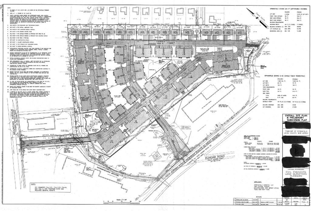
10 Site Plan
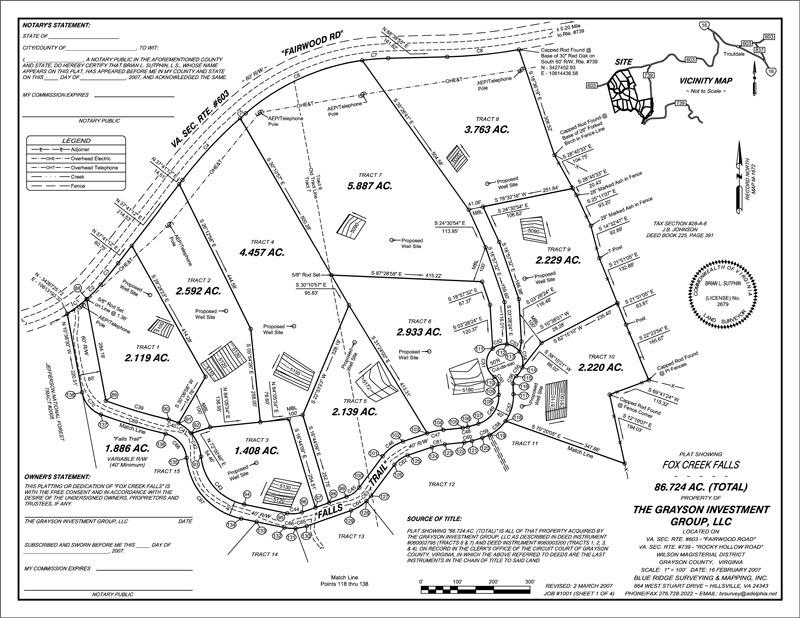
11 Subdivision Plan
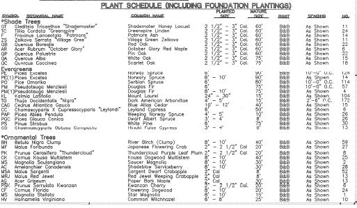
12 Reading Development Plan Symbols Contour lines existing, proposed, Drainage Systems function, subsurface structures, construction material, slopes, lengths Lighting Soils Vegetation

13 Topography contour lines

14 Measuring Slope Contour Interval NJ DEP defines steep slopes as those 20% and over

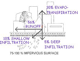
15 Steep slopes Development on steep slopes causes erosion, siltation, and increased runoff, contributing to downstream flooding


16 Slopes and Grading 25% slope +30% 15%


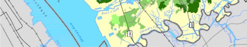
17 Design working with slopes

18 SOILS Do they drain well? Are they sandy or more like clay? Are they lying over high water table? Are they on steep slopes? What is the depth to bedrock? What is the erosion potential?
19 Vegetation Proposed

20 Landscape Plan 56 townhouse units on 30 acres
21
22 Development impacts water! Stormwater runoff Quality Volume Quantity Pattern Drainage Flooding potential Not taking these items into consideration during development review paves the way for increased flooding, erosion, habitat loss, loss of biodiversity, and diminished water quality.
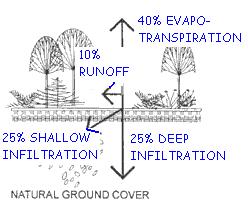
23 Stormwater Runoff
24 Recharge Recharge areas Septic disposal Potable drinking water Groundwater

25 Mapped Recharge Areas
26 Freshwater wetlands are regulated by the State (NJDEP) Municipalities cannot pass ordinances regulating wetlands, but they can help to insure that State regulations are followed. REQUIRE SUBMISSION OF LOI - The development application checklist should require applicant to check wetlands and soils maps, and submit an LOI (NJDEP Letter of Interpretation) if the property or adjacent property indicates possible presence of wetlands. CHECK ERI MAPS - to ensure that the applicant obtains an LOI, if merited, and shows wetlands and transition areas (protected buffer areas) on site plans. A site walk may reveal wetlands vegetation, signaling need for an LOI. Applications are approved contingent on obtaining State permits.
27 Evaluating Impacts: Know what is there now Existing conditions and critical resources from NRI/ERI Geology: Rock type, depth to bedrock Soils Suitability Water: surface water, wetlands, groundwater, water consumption, water system adequacy, fire protection Site contamination potential/land use history Wildlife, plant habitat Threatened and Endangered Neighborhood character and setting Adjacent activities/uses Other?
28 Evaluating Impacts On Site Development Activities Grading Landscaping Road Building Utility Installation Soil compaction Resource Impacts Soil Disturbance Loss of wetlands Runoff Erosion Habitat Loss Vegetation Loss
29 Evaluating Impacts Off Site Flooding Traffic Open space loss or degradation Loss of farmland, vistas Air quality Non point source pollution
30 General Site Plan /Subdivision Review Process Pre Application or Informal Meeting (not for variance applications) Application submission (including EIS, checklist, and wetlands delineation LOI) Application completeness determination Preliminary approval Final approval
31 The Application

32 Important maps Existing conditions Topography/Grading Drainage/Stormwater Landscaping/ Vegetation Removal Soil Erosion/ Sediment Control Utilities Lighting
33 Site Visit is Important Notify applicant Ask applicant to mark site boundaries, building footprints, wetlands Bring site plan Take photographs Determine points of concern Include site visit notes as part of the Commission s report
34 Analysis of Application Consistency with Master Plan Compliance with ORDINANCES Existing site and constraints, site during construction and upon completion Ability to provide basic services
35 Written Report by EC Findings of Fact Findings of Environmental Impacts Questions and Testimony at hearing
36 Cautions for Site Plan Review Site plan review is the implementation of existing master plan and ordinances Make sure your environmental ordinances are strong Variances may be appropriate to make the project fit the site better Conditions of approval must be in the Planning Board resolution or they are unenforceable

37 THANK YOU Call ANJEC Resource Center if you have questions
Environmental Resource Inventories. What are ERIs? Significance of information How to use them
 Environmental Resource Inventories What are ERIs? Significance of information How to use them Environmental Resource Inventory - ERI Compiled by the environmental commission Information about the natural
The Municipal Land Use Law, at N.J.S.A. 40:55D-89, includes the following statement relative to the periodic examination of a municipal Master Plan:
 2002 Periodic Reexamination Report of the Master Plan and Development Regulations for Lebanon Township, Hunterdon County, New Jersey May 16, 2002 (Adopted as revised on May 21, 2002) The Municipal Land
ANJEC Road Show May 22, 2013
 ANJEC Road Show May 22, 2013 Strategies for sustainable communities What is sustainability? Practices that meet the needs of the present without compromising the ability of future generations to meet their
Highlands Regional Master Plan
 Township of Montville Morris County, NJ Highlands Regional Master Plan prepared by Burgis Associates New Jersey Highlands Region 859,358 ac. Of that: Pl. Area Pres. Area 444,394 ac. 414,965 ac. Includes:
New Jersey Statewide Stormwater, Flood Hazard and Wetlands Programs
 New Jersey Statewide Stormwater, Flood Hazard and Wetlands Programs Authorities Federal Clean Water Act NJ Water Pollution Control Act NJ Stormwater Management Act Soil Erosion and Sediment Control Act
Environmental Check List Georgia Environmental Policy Act
 Environmental Check List Georgia Environmental Policy Act Project No. : Project Name: GEORGIA IS AREA AFFECTED? IF AFFECTED, HOW SEVERELY? AREA/CATEGORY NO YES UNKNOWN MINOR MEDIAN MAJOR UNKNOWN 1. Wetlands
WQMP AMENDMENT REVIEW CHECKLIST
 State of New Jersey Highlands Water Protection and Planning Council 100 North Road (Route 513) Chester, New Jersey 07930-2322 (908) 879-6737 (908) 879-4205 (fax) www.highlands.state.nj.us WQMP AMENDMENT
Regional Master Plan Consistency Report 1/8/2010
 of 47 11:31 AM Regional Master Plan Consistency Report Prepared by State of New Jersey Highlands Water Protection and Planning Council 100 North Road (Route 513), Chester, NJ 07930 Telephone: (908) 879-6737
Chapter 10 Natural Environment
 Chapter 10 Natural Environment Existing Conditions The Natural Environment Element addresses the protection, conservation, preservation, and restoration of the natural resources the Bayview Ridge Subarea,
TYPICAL CONTENTS OF A SITE-SPECIFIC NATURAL RESOURCE AND WOODLAND STAND DELINEATION MAP:
 TYPICAL CONTENTS OF A SITE-SPECIFIC NATURAL RESOURCE AND WOODLAND STAND DELINEATION MAP: A Site Context Map (1"=200') for vicinity within 1000' of the property Scale of map (to match scale of submitted
Charter Township of Garfield Grand Traverse County
 Charter Township of Garfield Grand Traverse County 3848 VETERANS DRIVE TRAVERSE CITY, MICHIGAN 49684 PH: (231) 941-1620 FAX: (231) 941-1588 SPECIAL USE PERMIT APPLICATION APPLICANT INFORMATION Name: Address:
Revised Code of Ordinances of the City of Hallowell (1997) SUBCHAPTER VIIIA SITE PLAN REVIEW
 SUBCHAPTER VIIIA SITE PLAN REVIEW") SUBCHAPTER VIIIA SITE PLAN REVIEW [Subchapter Derivation: Ord. No. 09-08, effective 7/23/2009] SECTION 9-861 PURPOSE The site plan review provisions set forth in this subchapter are intended to protect
SUBCHAPTER VIIIA SITE PLAN REVIEW [Subchapter Derivation: Ord. No. 09-08, effective 7/23/2009] SECTION 9-861 PURPOSE The site plan review provisions set forth in this subchapter are intended to protect
Consequences of Sprawl
 Loss of farmland Land conversion and stormwater runoff Water quality and quantity Loss of wildlife habitat Larger carbon footprint Lack of roadway connectivity and access Public health and safety Road
KANKAKEE COUNTY PLANNING DEPARTMENT APPLICATION FOR CLASS I & II GRADING AND DRAINAGE/STOMRWATER PERMIT APPLICATION
 KANKAKEE COUNTY PLANNING DEPARTMENT APPLICATION FOR CLASS I & II GRADING AND DRAINAGE/STOMRWATER PERMIT APPLICATION Michael J. Van Mill, AICP Planning Director 189 East Court Street Kankakee, IL 60901
Municipal Stormwater Management Plan Prepared For The Borough of Cape May Point By Van Note-Harvey Associates VNH File No.
 Municipal Stormwater Management Plan Prepared For The Borough of Cape May Point By Van Note-Harvey Associates 2005 VNH File No. 35317-210-21 Table of Contents Introduction... 3 Goals... 3 Storm water Discussion...
Ordinance No Lot Surface Drainage
 Ordinance No. 35-2008 - Lot Surface Drainage The Township has adopted a new Lot Surface Drainage Ordinance which amends Chapter 170, Article IX, Subdivision and Site Plan Review by adding a new Section
NEW JERSEY HIGHLANDS COUNCIL
 NEW JERSEY HIGHLANDS COUNCIL RELEASE OF PRELIMINARY TECHNICAL INFORMATION FOR THE REGIONAL MASTER PLAN June 2006 June 2006 Preliminary Information Release June 2006 Preliminary Information Release DRAFT
PUTNAM COUNTY COMPREHENSIVE PLAN EXHIBIT DD INFRASTRUCTURE ELEMENT
 COMPREHENSIVE PLAN EXHIBIT DD D. Infrastructure Element (Sanitary Sewer, Potable Water, Solid Waste, Drainage and Natural Groundwater Aquifer Recharge) Goals, Objectives and Policies GOAL D.1: Putnam County
COMMUNITY SUPPORT FOR ADOPTING WOODLAND CONSERVATION REGULATIONS EXAMPLE OF A WOODLAND CONSERVATION ORDINANCE STATEMENT OF PURPOSE:
 EXAMPLE OF A WOODLAND CONSERVATION ORDINANCE STATEMENT OF PURPOSE: To preserve wooded corridors that connect large tracts of forests to act as wildlife corridors, encouraging species diversity by providing
Model Riparian Buffer Ordinance.
 Model Riparian Buffer Ordinance. This is a sample riparian buffer ordinance written as an amendment to an existing zoning ordinance. This ordinance complies with the state minimum standards for river corridor
Chapter 21 Stormwater Management Bylaw
 Chapter 21 Stormwater Management Bylaw SECTION 1. PURPOSE The purpose of this Bylaw is to: implement the requirements of the National Pollutant Discharge Elimination System (NPDES) General Permit for Storm
FINAL SCOPING DOCUMENT
 State Environmental Quality Review Act (SEQR) FINAL SCOPING DOCUMENT HR Ventures Subdivision Town of Shawangunk, Ulster County, NY Draft Environmental Impact Statement SEQR CLASSIFICATION: UNLISTED ACTION
ATTACHMENT 1 GEPA CHECKLIST & Historical Archeological & Natural Heritage Preservation Documents
 ATTACHMENT 1 GEPA CHECKLIST & Historical Archeological & Natural Heritage Preservation Documents INTRODUCTION The 1991 Session of the Georgia General Assembly passed Senate Bill 97, as amended, and it
WELCOME ASSESSING ENVIRONMENTAL IMPACTS: CONSIDERING STATE REGULATIONS IN SITE PLAN REVIEW
 WELCOME ASSESSING ENVIRONMENTAL IMPACTS: CONSIDERING STATE REGULATIONS IN SITE PLAN REVIEW CONSIDERING STATE REGULATIONS IN SITE PLAN REVIEW ASSOCIATION OF NEW JERSEY ENVIRONMENTAL COMMISSIONS MARCH 30,
TORCH LAKE TOWNSHIP WATER QUALITY ACTION PLAN
 TORCH LAKE TOWNSHIP WATER QUALITY ACTION PLAN Elk-River-Chain-of-Lakes Gaps Analysis Project The Watershed Center Grand Traverse Bay Tip of the Mitt Watershed Council Michigan Department of Natural Resources
Site Plan Review -Tree Felling Application Supplement
 COMMUNITY DEVELOPMENT DEPARTMENT Planning Division P.O. Box 490 333 Broadalbin Street SW Albany, OR 97321 Phone 541-917-7550 Fax 541-791-0150 www.cityofalbany.net Site Plan Review -Tree Felling Application
State Environmental Quality Review Act (SEQR) SCOPING DOCUMENT
 SCOPING DOCUMENT") State Environmental Quality Review Act (SEQR) SCOPING DOCUMENT Debra Lasouska Cluster Subdivision Town of Shawangunk, Ulster County, NY Draft Environmental Impact Statement SEQR CLASSIFICATION: LEAD AGENCY:
State Environmental Quality Review Act (SEQR) SCOPING DOCUMENT Debra Lasouska Cluster Subdivision Town of Shawangunk, Ulster County, NY Draft Environmental Impact Statement SEQR CLASSIFICATION: LEAD AGENCY:
GRADING PERMIT CITY OF RAPID CITY 300 SIXITH STREET RAPID CITY, SD ID NO: (605) PIN NO:
 PIN NO:") PERMIT NUMBER: GRADING PERMIT CITY OF RAPID CITY 300 SIXITH STREET RAPID CITY, SD 57701 ID NO: (605) 394-4157 PIN NO: APPLICATION DATE: DATE ISSUED: PROPERTY INFORMATION CONTRACTOR INFORMATION LOT ADDRESS
PERMIT NUMBER: GRADING PERMIT CITY OF RAPID CITY 300 SIXITH STREET RAPID CITY, SD 57701 ID NO: (605) 394-4157 PIN NO: APPLICATION DATE: DATE ISSUED: PROPERTY INFORMATION CONTRACTOR INFORMATION LOT ADDRESS
Environmental Information Worksheet
 Environmental Information Worksheet Water System Owner (Attach additional sheets if necessary) Needs and Alternatives Provide a brief narrative that describes: Current drinking water system needs. Project
STORMWATER MANAGEMENT PLAN CONTENTS CHECKLIST Stormwater Management Plan Contents. SWMP Page # or Reference Location Yes/No
 STORMWATER MANAGEMENT PLAN CONTENTS CHECKLIST Stormwater Management Plan Contents Site Description A description of construction activity. The proposed sequence for major activities. Estimates of the total
Stormwater Erosion Control & Post-Construction Plans (Stormwater Quality Plans)
") Stormwater Erosion Control & Post-Construction Plans (Stormwater Quality Plans) Allen County Stormwater Plan Submittal Checklist The following items must be provided when applying for an Allen County Stormwater
Stormwater Erosion Control & Post-Construction Plans (Stormwater Quality Plans) Allen County Stormwater Plan Submittal Checklist The following items must be provided when applying for an Allen County Stormwater
WQMP AMENDMENT AREA-WIDE PROJECT REVIEW CHECKLIST
 State of New Jersey Highlands Water Protection and Planning Council 100 rth Road (Route 513) Chester, New Jersey 07930-2322 (908) 879-6737 (908) 879-4205 (fax) www.highlands.state.nj.us WQMP AMENDMENT
The ~ommonwealth of Nassachusetts
 DEVAL L. PATRICK GOVERNOR The ~ommonwealth of Nassachusetts Executive Ofice of Energy adenvironmentafflffairs 100 cambridge Street, Suite 900 Boston, MA 02114 TIMOTHY P. MURRAY LIEUTENANT GOVERNOR July
STREAM AND BUFFER AREA PROTECTION/RESTORATION
 STREAM AND BUFFER AREA PROTECTION/RESTORATION AMENDMENT OPTIONS TO STRENGTHEN POLICY IN HEADWATERS AREAS DRAFT SUBSEQUENT TO THE JANUARY 25, 2007 MEETING OF THE PLANNING COMMISSION ENVIRONMENT COMMITTEE
Will County Site Development Permit Submittal Checklist TAB 1 PROJECT OVERVIEW
 Applicant: Reviewer: Permit No.: The following tables contain a checklist of the requirements before a review for a Site Development Permit submittal will be accepted. Not all requirements pertain to every
DRAFT ENVIRONMENTAL IMPACT STATEMENT
 DRAFT ENVIRONMENTAL IMPACT STATEMENT FOR VILLAGE VIEW ESTATES VILLAGE OF WARWICK, ORANGE COUNTY, NEW YORK Garling Associates November 21, 2006 Date of Complete Filing: December 4, 2006 Village View, LLC
APPENDIX M CEQA Initial Study Checklist
 APPENDIX M CEQA Initial Study Checklist Appendix G ENVIRONMENTAL CHECKLIST FORM (To be Completed by Applicant) 1. Project title: 2. Lead agency name and address: 3. Contact person and phone number: 4.
Plan Review Background Paper Background Paper Number: 19 Planning & Development Department Date: September 2015
 Plan Review Background Paper Background Paper Number: 19 Planning & Development Department Date: September 2015 Environment Background East Hants is fortunate to enjoy the benefits of many natural resources
City of Mississauga Environmental Impact Studies Terms of Reference 2002
 City of Mississauga Environmental Impact Studies Terms of Reference 2002 1.0 INTRODUCTION To ensure in so far as possible, both private and public developments are consistent with Natural Heritage and
BANKS TOWNSHIP WATER QUALITY ACTION PLAN
 BANKS TOWNSHIP WATER QUALITY ACTION PLAN Elk-River-Chain-of-Lakes Gaps Analysis Project The Watershed Center Grand Traverse Bay Tip of the Mitt Watershed Council Michigan Department of Natural Resources
LAND LIMITATION ENVIRONMENTAL LIMITATIONS
 LAND LIMITATION ENVIRONMENTAL LIMITATIONS Floodplains An ideal municipal solid waste landfill will have little or no floodplain areas within its boundaries. A site located within the 100-year floodplain,
DEKALB COUNTY STORMWATER MANAGEMENT PLAN PHASE 2
 DEKALB COUNTY STORMWATER MANAGEMENT PLAN PHASE 2 Introduction DeKalb County, Illinois, located approximately 50 miles west of Lake Michigan, is rectangular in shape, with a north/south dimension of 36
Chapter 3 Dispersion BMPs
 Chapter 3 Dispersion BMPs 3.1 BMP L611 Concentrated Flow Dispersion 3.1.1 Purpose and Definition Dispersion of concentrated flows from driveways or other pavement through a vegetated pervious area attenuates
STANDARDS TO ADDRESS THE ENVIRONMENTAL FACTORS
 94-412 SACO RIVER CORRIDOR COMMISSION Chapter 103: STANDARDS TO ADDRESS THE ENVIRONMENTAL FACTORS SUMMARY: All projects approved must show no unreasonable a) degradation of water and water quality, b)
APPENDIX I. Plan Reviewer Checklist
 APPENDIX I Plan Reviewer Checklist PLAN REVIEW CHECKLIST Annual Standards and Specifications The ESC/SWM Plan clearly indicates the version of Virginia Tech Annual Standards and Specifications applicable.
iswm TM Criteria Manual City of Azle Section 14 City of Azle Subdivision Ordinance DRAFT-June Chapter 1
 City of Azle Section 14 City of Azle Subdivision Ordinance DRAFT-June 2010... Chapter 1 i CITY OF AZLE iswm CRITERIA MANUAL FOR SITE DEVELOPMENT AND CONSTRUCTION Incorporating the Regional NCTCOG Integrated
TAC CHARRETTE WORKBOOK Ecosystem Management and Sustainable Forestry Practices
 For Discussion Purposes TAC CHARRETTE WORKBOOK Ecosystem Management and Sustainable Forestry Practices NEW JERSEY HIGHLANDS COUNCIL March 28, 2006 1 Overview of RMP Goals and Structure NEW JERSEY HIGHLANDS
D R A F T (October 6, 2009) Comparison of Highlands Plan Conformance versus Non-Conformance for Rockaway Township s Planning Area
 Comparison of Highlands Plan Conformance versus Non-Conformance for Rockaway Township s Planning Area") D R A F T (October 6, 2009) Comparison of Highlands Plan Conformance versus Non-Conformance for Rockaway Township s Planning Area Item # Plan Conformance (opt in) Non-Conformance (opt out) Opt In (Y/N)
D R A F T (October 6, 2009) Comparison of Highlands Plan Conformance versus Non-Conformance for Rockaway Township s Planning Area Item # Plan Conformance (opt in) Non-Conformance (opt out) Opt In (Y/N)
Chapter 7: Utilities and Stormwater Management
 Chapter 7: Utilities and Stormwater Management Utilities are essential services that affect future land use and growth areas, stormwater management, and energy use. Chapter 7 of this Comprehensive Plan
ELK RAPIDS TOWNSHIP WATER QUALITY ACTION PLAN
 ELK RAPIDS TOWNSHIP WATER QUALITY ACTION PLAN Elk-River-Chain-of-Lakes Gaps Analysis Project The Watershed Center Grand Traverse Bay Tip of the Mitt Watershed Council Michigan Department of Natural Resources
Rio Arriba County Planning & Zoning Department
 Rio Arriba County Planning & Zoning Department Conditional Use Permit or Special Use Permit GENERAL INFORMATION (please print or type) NAME OF DEVELOPMENT and/or APPLICANT ADDRESS OF APPLICANT TELEPHONE
SANTA CLARA Protections in place:
 SANTA CLARA s in place: General Plan Language Specific Tree Retention/ Replacement The Tree prohibits cutting 12 dbh trees on hillside zone parcels
Nassau County 2030 Comprehensive Plan. Conservation Element (CS) Goals, Objectives and Policies. Goal
 Goals, Objectives and Policies. Goal") (CS) Goal Conserve, protect and enhance the natural resources that are important to the economy, health, and quality of life of County residents, ensuring that adequate resources are available for future
(CS) Goal Conserve, protect and enhance the natural resources that are important to the economy, health, and quality of life of County residents, ensuring that adequate resources are available for future
Instructions for Notice of Ground Disturbance Form:
 Instructions for Notice of Ground Disturbance Form: Prior to beginning any ground disturbance activity or finalizing your storm water plan, submit a completed 2 page Notice of Ground Disturbance Form to
Environment & Conservation Introduction
 Environment & Conservation Introduction Anacortes is blessed with an abundance of natural beauty. Residents identify marine shorelines, streams, lakes, forested areas, and other natural features as defining
Understanding and Applying the State Environmental Quality Review Act
 Understanding and Applying the State Environmental Quality Review Act Monday, April 23, 2018 Presented by: Donald A. Young, Esq. SEQR Overview What is SEQR? New York State regulations more formally known
Nassau County 2030 Comprehensive Plan. Conservation Element (CS) Goals, Objectives and Policies. Goal
 Goals, Objectives and Policies. Goal") (CS) Goal Conserve, and protect and enhance the natural resources that are important to the economy, health, and quality of life of County residents, ensuring that adequate resources are available for
(CS) Goal Conserve, and protect and enhance the natural resources that are important to the economy, health, and quality of life of County residents, ensuring that adequate resources are available for
BMPs TO CONSERVE WOODED AREAS AT THE SUBDIVISION LEVEL
 BMPs to Conserve Wooded Areas 31 BMPs TO CONSERVE WOODED AREAS AT THE SUBDIVISION LEVEL Audience This section is primarily directed toward: local units of government, landowners and developers, builders
Natural Systems Planning Primer
 Natural Systems Planning Primer Lise.Guevremont@ottawa.ca Amy.Macpherson@ottawa.ca Land Use and Natural Systems Unit Planning and Growth Management November 2015 1 Welcome Policy Framework Development
CLEARWATER TOWNSHIP WATER QUALITY ACTION PLAN
 CLEARWATER TOWNSHIP WATER QUALITY ACTION PLAN Elk-River-Chain-of-Lakes Gaps Analysis Project The Watershed Center Grand Traverse Bay Michigan Department of Environmental Quality July 2011 Purpose The Grand
TOWN OF MANCHESTER PLANNING AND ZONING COMMISSION. GENERAL APPLICATION FORM (Please TYPE or PRINT CLEARLY all information)
") TOWN OF MANCHESTER PLANNING AND ZONING COMMISSION AND INLAND WETLANDS AGENCY GENERAL APPLICATION FORM (Please TYPE or PRINT CLEARLY all information) 1. OWNER/APPLICANT INFORMATION Applicant: Last Name
TOWN OF MANCHESTER PLANNING AND ZONING COMMISSION AND INLAND WETLANDS AGENCY GENERAL APPLICATION FORM (Please TYPE or PRINT CLEARLY all information) 1. OWNER/APPLICANT INFORMATION Applicant: Last Name
PLANNED UNIT DEVELOPMENT & SUBDIVISION STAFF REPORT Date: July 11, 2013
 PLANNED UNIT DEVELOPMENT & SUBDIVISION STAFF REPORT Date: July 11, 2013 SUBDIVISION NAME DEVELOPMENT NAME LOCATION Northside LTD/Joint Venture Subdivision, Resubdivision of and Addition to Lot 3A Northside
Trees as part of a Resilient Region
 Trees as part of a Resilient Region City of Grand Rapids Suzanne Schulz Design & Development Planning, Managing Director GI Benefits and Practices Why Trees are Important Reduces Stormwater Runoff Increases
Conservation, Open Space & Groundwater Recharge Element
 Conservation, Open Space & Groundwater Recharge Element GOAL 1 ESTABLISH AND MAINTAIN AN INTEGRATED AND URBAN-DEFINING OPEN SPACE NETWORK THAT PROTECTS AND CONSERVES KEY ENVIRONMENTAL FEATURES. Objective
Sustainable Water Resource Practices
 Sustainable Water Resource Practices This section is related to and shoudl be read in conjunction with the Land Use Element, and Conservation Element. Implementing sustainable water resource practices
Town of Dover P.O. Box 428 West Dover, VT (802)
") Town of Dover P.O. Box 428 West Dover, VT 05356 (802) 464-8720 DOVER DEVELOPMENT REVIEW BOARD NOTICE OF DECISION Application 17-MS300-01 A. PROCEDURAL HISTORY & APPLICANT REQUEST 1. Landowner: Mount Snow
Town of Dover P.O. Box 428 West Dover, VT 05356 (802) 464-8720 DOVER DEVELOPMENT REVIEW BOARD NOTICE OF DECISION Application 17-MS300-01 A. PROCEDURAL HISTORY & APPLICANT REQUEST 1. Landowner: Mount Snow
VILLAGE OF BELLAIRE WATER QUALITY ACTION PLAN
 VILLAGE OF BELLAIRE WATER QUALITY ACTION PLAN Elk-River-Chain-of-Lakes Gaps Analysis Project The Watershed Center Grand Traverse Bay Tip of the Mitt Watershed Council Michigan Department of Natural Resources
SECTION 10: WETLANDS PROTECTION
 SECTION 10: WETLANDS PROTECTION 10-1 INTENT AND PURPOSE A. Intent 1. The City finds that wetlands serve a variety of beneficial functions. Wetlands maintain water quality, reduce flooding and erosion,
CITY OF JENKS EARTH CHANGE PERMIT APPLICATION
 CITY OF JENKS EARTH CHANGE PERMIT APPLICATION Any applicable State or Federal permits must be attached to this application or must be applied for with copies attached to this application if this permit
BMP 5.4.2: Protect /Conserve/Enhance Riparian Areas
 BMP 5.4.2: Protect /Conserve/Enhance Riparian Areas The Executive Council of the Chesapeake Bay Program defines a Riparian Forest Buffer as "an area of trees, usually accompanied by shrubs and other vegetation,
Stormwater Control Plan for Post Construction Requirements Exhibit 4
 Stormwater Control Plan for Post Construction Requirements Exhibit 4 Application Submittal Where directions state Done that means no additional information or forms below that point needs to be filled
CATEGORY a protection of the natural environment, its ecosystems and biodiversity.
 29. ENVIRONMENTAL DEVELOPMENT PERMIT AREA CATEGORY a protection of the natural environment, its ecosystems and biodiversity. The requirement to obtain an environmental development permit is cited in Section
TOWN OF WINDSOR, CONNECTICUT INLAND WETLANDS & WATERCOURSES COMMISSION. 1. APPLICANT Name: Phone: Address: Cell:
 TOWN OF WINDSOR, CONNECTICUT INLAND WETLANDS & WATERCOURSES COMMISSION This application form is intended to expedite the work of the Town Staff, the Town Inland Wetlands and Watercourses Commission, and
SCRCA SECTION 28 WETLAND POLICY
 April 21, 2016 SCRCA SECTION 28 WETLAND POLICY SCRCA Policies and Procedures of Administration of Section 28 Regulations Wetland Policies Definitions section (Source: Section 28 CA Act) Development means:
City of Valdosta Land Development Regulations
 Chapter 324 Section 324-1 Environmental Planning Criteria Protection of Groundwater Recharge Areas (A) Purpose and Intent. Pursuant to O.C.G.A. 12-2-8 and the Georgia Department of Natural Resources (DNR),
PERMIT APPLICATION FEES Fees must be paid at time of application
 Permits SEPA Checklist Permit # Staff use Governmental agencies use this checklist to help determine whether the environmental impacts of your proposal are significant. This information is also helpful
Maitland Valley WATERSHED
 Maitland Valley WATERSHED Report Card 2018 Maitland Conservation has prepared this report card as a summary of the state of your forests, wetlands, and water resources. WHERE ARE WE? We are one of 36 Conservation
Town of Friday Harbor PO Box 219 / Friday Harbor / WA / (360) / fax (360) /
 / fax (360) /") Town of Friday Harbor PO Box 219 / Friday Harbor / WA / 98250 (360) 378-2810 / fax (360) 378-5339 / www.fridayharbor.org LAND CLEARING, GRADING, OR FILLING PERMIT APPLICATION APPLICATION DATE GRD No. APPLICANT/FRANCHISE
Town of Friday Harbor PO Box 219 / Friday Harbor / WA / 98250 (360) 378-2810 / fax (360) 378-5339 / www.fridayharbor.org LAND CLEARING, GRADING, OR FILLING PERMIT APPLICATION APPLICATION DATE GRD No. APPLICANT/FRANCHISE
MINNEHAHA CREEK WATERSHED DISTRICT BOARD OF MANAGERS REVISIONS PURSUANT TO MINNESOTA STATUTES 103D.341. Adopted April 24, 2014 Effective June 6, 2014
 MINNEHAHA CREEK WATERSHED DISTRICT BOARD OF MANAGERS REVISIONS PURSUANT TO MINNESOTA STATUTES 103D.341 Adopted April 24, 2014 Effective June 6, 2014 EROSION CONTROL RULE 1. POLICY. It is the policy of
Figure 1: P Area. Alpha Borough. Preservation Area Municipal Boundaries. Phillipsburg Town. Greenwich Township. Alpha Borough. Pohatcong Township
 Figure 1: P Area BOROUGH OF ALPHA Figure 2: Land Use Capability Map Zones Regional Master Plan Overlay Zone Designation Zone Protection Lakes Greater Than 10 acres Conservation Existing Community Sub-Zone
MILTON TOWNSHIP WATER QUALITY ACTION PLAN
 MILTON TOWNSHIP WATER QUALITY ACTION PLAN Elk-River-Chain-of-Lakes Gaps Analysis Project The Watershed Center Grand Traverse Bay Tip of the Mitt Watershed Council Michigan Department of Natural Resources
Shoreland Protection Innovative Model Ordinance
 Shoreland Protection Innovative Model Ordinance Southern New Hampshire Planning Commission September 14, 2007 Innovative Land Use Guide Training Presented By: Jack Munn, Senior Planner, SNHPC For Questions
Draft Future Land Use Chapter as Presented to the Danville Planning Board February 24, Future Land Use 1-1
 1. Future Land Use 1-1 FUTURE LAND USE Introduction The Future Land Use section of the Master Plan reflects the desired long-range development pattern for Danville. It is a plan designed to encourage compatible
Highlands Initial Assessment Report
 Highlands Initial Assessment Report Borough of Ringwood Passaic County, New Jersey February 2009 Prepared by the Ringwood Borough Planning Board In consultation with Banisch Associates, Inc. Flemington,
Municipal Stormwater Management Planning
 Municipal Stormwater Management Planning Christopher C. Obropta, Ph.D., P.E. Water Resources Extension Specialist with Rutgers Cooperative Extension Assistant Professor with Department of Environmental
Town of Windham Land Use Ordinance Table of Contents
 Town of Windham Land Use Ordinance Table of Contents SECTION 100 GENERAL 101 Title... 1-1 102 Purpose... 1-1 103 Severability Clause... 1-1 104 Conflicts... 1-2 105 Conformance Required... 1-2 106 Rules
TOWN OF MANCHESTER PLANNING AND ZONING COMMISSION Subdivision Application Minimum Submission Requirements
 TOWN OF MANCHESTER PLANNING AND ZONING COMMISSION Subdivision Application Minimum Submission Requirements This checklist is to be completed and submitted with all Subdivision Applications. The Town reserves
Erosion & Sedimentation Control Policy
 Issue Date 10/22/2010 Page 1 of 8 Erosion & Sedimentation Control Policy Introduction: Soil erosion is the removal of soil by water, wind, ice or gravity and sediment deposition occurs when the rate of
City of Bishop. Environmental Checklist Form
 City of Bishop Environmental Checklist Form 1. Project title: Environmental Review / 2007 California Building Codes 2. Lead agency name and address: City of Bishop 377 W. Line Street Bishop, Ca 93514 3.
A. Growth management, resource land conservation, and critical areas protection share problems related to governmental costs and efficiency.
 CITY OF MOSES LAKE MUNICIPAL CODE CHAPTER 19.03 CLASSIFICATION AND DESIGNATION OF RESOURCE LANDS AND CRITICAL AREAS AND REGULATIONS FOR THE CONSERVATION AND PROTECTION OF RESOURCE LANDS AND CRITICAL AREAS
1006 UTILITIES, STREET LIGHTS, WATER SUPPLY, SEWAGE DISPOSAL, SURFACE WATER MANAGEMENT, AND EROSION CONTROL
 1006 UTILITIES, STREET LIGHTS, WATER SUPPLY, SEWAGE DISPOSAL, SURFACE WATER MANAGEMENT, AND EROSION CONTROL 1006.01 GENERAL STANDARDS A. The location, design, installation, and maintenance of all utility
SNOW REMOVAL & DISPOSAL POLICY
 PHILIP D. MURPHY Governor SHEILA Y. OLIVER Lt. Governor DEPARTMENT OF ENVIRONMENTAL PROTECTION Mail Code 401-02B Division of Water Quality 401 E State St P.O. Box 420 Trenton, NJ 08625-0420 CATHERINE R.
Sample Municipal Stormwater Management Plan
 New Jersey Stormwater Best Management Practice Manual FINAL DRAFT December 2003 http://www.state.nj.us/dep/watershedmgt/bmpmanual2003.htm A P P E N D I X C Sample Municipal Stormwater Management Plan This
Review Zone Application for D&R Canal Commission Decision
 Review Zone Application for D&R Canal Commission Decision MEETING DATE: January 18, 2017 DRCC #: 16-3020C Latest Submission Received: January 10, 2016 Applicant: PVP Franklin, LLC 769 Northfield Avenue,
Capital Facilities Element
 Capital Facilities Element Purpose The Growth Management Act requires cities to prepare a capital facilities element consisting of: 1. An inventory of current capital facilities owned by public entities,
DRAFT FOR CONSIDERATION AT THE APRIL 27, 2006 MEETING OF NATURAL RESOURCES COMMITTEE OF THE HIGHLANDS COUNCIL
 RMP Component: Resource Assessment / Ecosystem Assessment Technical Report: Forest Integrity Council Committee: Natural Resource Committee Memorandum Title: Technical Approach to Define Highlands Forest
INVESTIGATING YOUR STREAM S DRAINAGE BASIN
 IT S OUR WATER INVESTIGATING YOUR STREAM S STREAM ACTIVITY SUMMARY Using maps, students will determine land uses in the drainage basin of their stream and calculate the approximate percentage of impervious
VEGETATIVE, WATER, FISH AND WILDLIFE RESOURCES POLICIES
 VEGETATIVE, WATER, FISH AND WILDLIFE RESOURCES POLICIES The County will: GOALS AND OBJECTIVES 1.1 Conserve, Enhance, Protect, Maintain and Manage Vegetative, Water, Fish and Wildlife Resources Promote
STAFF REPORT FOR POLICY PLAN AMENDMENT S10-CW-1CP
 STAFF REPORT FOR POLICY PLAN AMENDMENT S10-CW-1CP EXECUTIVE SUMMARY This Plan Amendment would serve to clarify policy guidance regarding circumstances under which proposals for disturbances to Environmental
CHAPTER 1 NATURAL RESOURCES, OPEN SPACE, AND FARMLAND
 CHAPTER 1 NATURAL RESOURCES, OPEN SPACE, AND FARMLAND The towns of Buckland and Shelburne lie west of Greenfield, in the foothills of the Berkshire Mountains. Both Buckland and Shelburne are fortunate