SECTION 1 - TRANSPORTATION NETWORK SECTION 2 - SITE INFORMATION
|
|
|
- Julius Cook
- 5 years ago
- Views:
Transcription
1

2
3 TABLE OF CONTENTS SECTION 1 - TRANSPORTATION NETWORK INTERSTATE AVAILABILITY (MAP): TEXAS INTERSTATE HIGHWAYS TEXAS SOUTH LOOP 9 PROJECT (AERIAL PHOTO): PROPOSED ROUTE (TXDOT MAJOR ROADWAY) TEXAS SOUTH LOOP 9 PROJECT (AERIAL PHOTO): I-35E TO I-45 (TXDOT MAJOR ROADWAY) FM 664/ OVILLA ROAD (AERIAL PHOTO): IMPROVEMENTS & WIDENING (TXDOT MAJOR ROADWAY) AIR TRAVEL (MAP): NORTH AMERICAN COUNTRIES TEXAS RAILWAY (MAP): BNSF & UNION PACIFIC ROUTES TEXAS PORTS OF AUTHORITY (MAP): FAST FACTS: TEXAS GULF PORTS SECTION 2 - SITE INFORMATION STATE OF TEXAS (MAP): CITY OF RED OAK IDENTIFIED STRATEGIC LOCATION (AERIAL PHOTO): NORTH CENTRAL TEXAS REGION (CITY OF RED OAK IDENTIFIED) ELLIS COUNTY, TEXAS (MAP): CITY OF RED OAK IDENTIFIED PROPERTY DESCRIPTION (AERIAL PHOTO): CURRENT ZONING AND FUTURE PLANNED ZONING SECTIONS 1 3: PROPERTY SURVEY & FIELD NOTES DESCRIPTION o SECTION 1: PROPERTY SURVEY AND FIELD NOTES ( ACRES) o SECTION 2A: PROPERTY SURVEY AND FIELD NOTES ( ACRES) o SECTION 2B: PROPERTY SURVEY AND FIELD NOTES ( ACRES) o SECTION 3: PROPERTY SURVEY AND FIELD NOTES ( ACRES)
4 TABLE OF CONTENTS SECTION 2 - SITE INFORMATION - CONTINUED EXISTING TRANSPORTATION INFRASTRUCTURE: SITE INGRESS & EGRESS, INTERSTATE ROUTES, RAIL EXISTING INFRASTRUCTURE (MAP): TRANSPORTATION, WATER, WASTE WATER, ELECTRICITY, NATURAL GAS EXISTING WATER UTILITIES INFRASTRUCTURE (AERIAL & MAP): WATER UTILITIES & INFRASTRUCTURE EXISTING WASTE WATER UTILITIES INFRASTRUCTURE (MAP): WASTE WATER UTILITIES & INFRASTRUCTURE EXISTING ELECTRICAL UTILITIES INFRASTRUCTURE (AERIAL PHOTO): SUBSTATION AND TRANSMISSION LINE EXISTING AT&T INFRASTRUCTURE (MAPS): NWQ TX STATE HIGHWAY 342 & FM 664/OVILLA ROAD & VICINITY EXISTING NATURAL GAS INFRASTRUCTURE (MAP): TEXAS STATE HIGHWAY 342 & FM 664/OVILLA ROAD & VICINITY PROPOSED UTILITIES & INFRASTRUCTURE (MAP): PLANNED IMPROVEMENTS FIRM FLOOD INSURANCE RATE (MAP): PANEL 0075F (ELLIS COUNTY, TEXAS) USGS TOPOGRAPHIC MAP: SITE TOPOGRAPHY & CONTOUR LINES (SECTIONS 1-3 IDENTIFIED) o USGS TOPOGRAPHIC AERIAL PHOTO: SITE TOPOGRAPHY & CONTOUR LINES (SECTIONS 1-3 IDENTIFIED) GEOTECHNICAL DATA (MAP): SOIL SURVEY (SECTIONS 1 3) SITE DEVELOPMENT ANALYSIS: SECTIONS 1 3 o 404 DELINEATION (CLEAN WATER ACT) o SECTION 1 (100 YEAR FLOODPLAIN) o SECTION 2 (100 YEAR FLOODPLAIN) o SECTION 3 (100 YEAR FLOODPLAIN) o USACE PERMITTING
5 TRANSPORTATION NETWORK


6 INTERSTATE AVAILABILITY INTERSTATE 35 E. 2 MINUTES I 35E: I 20: I 45: I 30: 1.4 MILES / 2 MINUTES 8 MILES / 10 MINUTES 9 MILES / 15 MINUTES 28 MILES / 24 MINUTES I 35W: 43 MILES / 43 MINUTES I 10: 228 MILES / 3 + HOURS I 110: 642 MILES / 9 HOURS 7 INTERSTATE HIGHWAYS WITHIN 9 HOURS!


7 TXDOT HIGHWAY IMPROVEMENTS FM 664/OVILLA ROAD S. LOOP 9 (SOURCE: ECONOMIC DEVELOPMENT DEPARTMENT. CITY OF RED OAK, TEXAS. 2019)


8 SOUTH LOOP 9 ROUTE PROPOSED ROUTE PROPOSED SITE 9.5 MILE SECTION PROPOSED S. LOOP 9 ROUTE SOUTHEAST CORRIDOR MIDDLE REGION TXDOT PROJECT THE PLANNED SOUTH LOOP 9 IS A STATE OF TEXAS HIGHWAY THAT WILL BE LOCATED ALONG THE SOUTHERN DALLAS COUNTY AND NORTHERN ELLIS COUNTY LINES. THE SECTION OF LOOP 9 CONNECTING I 45 (TO THE EAST) WITH I 35 (TO THE WEST) WILL BE APPROXIMATELY 9.5 MILES IN LENGTH. THIS 9.5 MILE SECTION WILL BE LOCATED IMMEDIATELY TO THE NORTH OF THE PROPOSED INDUSTRIAL PROPERTY.
9 SOUTH LOOP 9 ROUTE PROPOSED ROUTE SOUTH LOOP 9 PROPOSED ROUTE S. E. CORRIDOR (MIDDLE REGION) PROPOSED SITE PROPOSED SITE LOOP 9: PROJECT INFORMATION First Section from I 35E to I 45 (Approximately 9.5 Miles in Length) Six lane new location frontage road system between I 35E and I 45 through Dallas and Ellis counties, Texas. (Source: Texas Department of Transportation. Dallas District Office. August 1, 2017)


10 TEXAS S. LOOP 9 CONNECTS I-35E TO I-45 PROPOSED SITE SOUTH LOOP 9 R-O-W ACQUISITION IN PROGRESS TXDOT HAS FUNDED S. LOOP 9 CONSTRUCTION
11 FM 664 / OVILLA ROAD PROPOSED SITE PROPOSED Proposed Proposed SITE Site Site OVILLA ROAD/ FM 664 FM 664/Ovilla Road, a major access road for northern Ellis County, extends from I 45 (to the east) to US 287 (to the west). Phase 1: FM 664/Ovilla Road is in the process of being widened and improved to six lane, divided highway extending westward from I 35 to Westmoreland Road. Phase 2: FM 664/Ovilla Road will be improved and widened to a six lane divided highway extending eastward from SH 342 (Project proposed site location) to I 45.


12 FM 664 / OVILLA ROAD CONNECTS US 287 WITH I-45 Proposed Proposed Site Site FM 664 SEGMENT I 35E TO S. WESTMORELAND ROAD NOW UNDER CONSTRUCTION: 440 DAYS TIME FROM OCTOBER 1, 2018 FM 664 SEGMENTS ARE IN THE DESIGN & PUBLIC APPROVAL PHASE TXDOT HAS FUNDED CONSTRUCTION (SOURCE: ECONOMIC DEVELOPMENT DEPARTMENT. CITY OF RED OAK, TEXAS. 2019)

13 AIR TRAVEL WORLDWIDE ACCESSIBILITY 191 WORLDWIDE DESTINATIONS D/FW AIRPORT 38 MILES / 39 MINS. 191 DESTINATIONS WORLDWIDE 55 GATES 20 PASSENGER AIRLINES 7 RUNWAYS WORLD RANKINGS: 4 TH - OPERATIONS 8 TH - PASSENGERS 4 HOURS TO EAST & WEST COASTS: 50 MILLION PEOPLE & 70 + MAJOR MARKETS WITHIN 24 HOURS DALLAS LOVE 24 MILES / 26 MINS. 10 MAJOR US DESTINATIONS 19 GATES 2 TERMINALS 4 PASSENGER AIRLINES 8 MILLION PASSENGERS PER YEAR

14 TEXAS RAILWAY MAP BNSF & UNION PACIFIC ROUTES TEXAS RAILWAY MAP BNSF & UNION PACIFIC ROUTES UNION PACIFIC BNSF (SOURCE: TEXAS ECONOMIC DEVELOPMENT. OFFICE OF THE GOVERNOR. STATE OF TEXAS)
15 TEXAS PORTS OF AUTHORITY FAST FACTS: TEXAS GULF COAST PORTS HANDLE MILLION TONS OF FOREIGN & DOMESTIC CARGO ANNUALLY = 20 % OF ALL U.S. PORT TONNAGE. ANNUALLY GENERATE $270 BILLION IN ECONOMIC ACTIVITY & $6 BILLION IN STATE & LOCAL TAXES (SOURCE: THE TEXAS PORTS ASSOCIATION) SEVEN (7) TEXAS PORTS RANK IN THE TOP 50 U.S. PORTS IN ANNUAL TONNAGE INCLUDING: HOUSTON (2 ND ) BEAUMONT (6 TH ) CORPUS CHRISTI (7 TH ) TEXAS CITY (11 TH ) (SOURCE: TEXAS DEPARTMENT OF TRANSPORTATION) PORT OF GALVESTON RANKED 4 TH LARGEST U.S. CRUISE MARKET BASED ON EMBARKATION: 863,000 + PASSENGERS AND CREW (2012) (SOURCE: U.S. DEPARTMENT OF TRANSPORTATION) Will Whitehouse Senior Trade Development Manager E: wwhitehouse@poha.com PortHouston.com O: F: M: East Loop North Houston, Texas 77029
16 SITE INFORMATION

17 STATE of TEXAS

 I 35E: 1.")

18 STRATEGIC LOCATION! NORTH CENTRAL TEXAS REGION LOCATION, LOCATION, LOCATION! DALLAS: 18 MILES (N) FT. WORTH: 42 MILES (NW) I 35E: 1.4 MILES / 2 MINUTES I 20: 8 MILES/ 10 MINUTES I 45: 9 MILES/ 15 MINUTES I 30: 28 MILES/ 24 MINUTES I 35W: 43 MILES/ 43 MINUTES 5 INTERSTATE HIGHWAYS WITHIN 43 MILES / 43 MINUTES!


19 ELLIS COUNTY, TEXAS Tarrant County Dallas County RED OAK, TEXAS
20 PROPERTY DESCRIPTION PROPERTY ZONING 1 2A INDUSTRIAL PROPERTY 3 2B TOTAL ACRES IMMEDIATELY AVAILABLE SECTIONS 1 3: WALTON GLOBAL HOLDINGS ACRES TO BE ZONED INDUSTRIAL: ~90 DAYS TIME REQUIRED

 74.")

21 SECTION 1 SURVEY & FIELD NOTES SECTION 1 (ROIDC) ACRES AVAILABLE
22 SECTION 2A SURVEY & FIELD NOTES SECTION 2A (ROIDC) ACRES AVAILABLE
23 SECTION 2B SURVEY & FIELD NOTES SECTION 2B (ROIDC) ACRES AVAILABLE
24 SECTION 3 SURVEY & FIELD NOTES SECTION 3 (ROIDC) ACRES AVAILABLE

25 UTILITIES & INFRASTRUCTURE
26 TRANSPORTATION INFRASTRUCTURE SITE INGRESS & EGRESS, INTERSTATE ROUTES, RAIL I 35E: 1.5 MILES I 20: 8.0 MILES FM 664: ADJACENT SH 342: ADJACENT BNSF/UP RAIL: ADJACENT UP INTERMODAL: 6.9 MILES (NE) Z SITE INGRESS & EGRESS POINTS US 287: 10.4 MILES D/FW AIRPORT: 38 MILES/39 MINS. DALLAS LOVE: 24 MILES/26 MINS.
27 EXISTING UTILITIES & INFRASTRUCTURE
28 UTILITY INFRASTRUCTURE MAP EXISTING INFRASTRUCTURE 1 2A EXISTING INFRASTRUCTURE 3 2B HIGHWAYS: 5 INTERSTATES < 45 MINS. TEXAS SH 342 FM 664 (OVILLA RD.) RAIL (ADJACENT): UNION PACIFIC- OPERATOR BNSF - OWNER WATER: 36 MAIN & 12 MAIN NATURAL GAS: 6 TRANSMISSION ELECTRICITY: 138kV TRANSMISSION MAIN ELECTRIC SUBSTATION: 47 MVA TRANSFORMERS (2 EA.) WASTEWATER: GRAVITY FLOW
29 EXISTING WATER UTILITIES
30 EXISTING WATER UTILITIES 1 2A 3 2B
31 EXISTING WATER UTILITIES 1 2A 2B 3
32 EXISTING WASTE WATER UTILITIES
33 PROPOSED SITES 1 3 2A 2B WALTON GLOBAL HOLDINGS ACRES 1 2A PROPOSED SITES 3 2B WALTON GLOBAL HOLDINGS ACRES EXISTING WASTE WATER UTILITIES
34 EXISTING ELECTRICAL UTILITIES
35 1 2A 3 2B WALTON GLOBAL HOLDINGS ACRES EXISTING ELECTRICAL UTILITIES
36 EXISTING AT&T INFRASTRUCTURE
37 AT&T INFRASTRUCTURE NWC FM 664 & TX STATE HWY 342 It is AT&T s current policy to supply copper and fiber to all new buildings that have a reasonable expectation to order a fiber circuit. So once we have a plat, for a building to begin, then we will start a job to supply that building with our facilities. Thanks, James Wehunt Mgr OSP Plng & Engrg Design AT&T Texas 2513 W E Roberts ST Grand Prairie, TX (972) Jw2464@att.com WALTON GLOBAL HOLDINGS ACRES
38 AT&T INFRASTRUCTURE FM 664 & THOUSTON SCHOOL ROAD It is AT&T s current policy to supply copper and fiber to all new buildings that have a reasonable expectation to order a fiber circuit. So once we have a plat, for a building to begin, then we will start a job to supply that building with our facilities. Thanks, James Wehunt Mgr OSP Plng & Engrg Design AT&T Texas 2513 W E Roberts ST Grand Prairie, TX (972) Jw2464@att.com FM 664/ OVILLA ROAD
39 EXISTING NATURAL GAS INFRASTRUCTURE
40 EXISTING NATURAL GAS INFRASTRUCTURE TEXAS STATE HWY 342 WALTON GLOBAL HOLDINGS ACRES NATURAL GAS PROVIDER PROXIMITY OF NATURAL GAS LINE TO SITE SIZE (OR CAPACITY) OF NATURAL GAS LINE TO SITE PRESSURE OF THE NATURAL GAS LINE AT THE SITE. GATEWAY ENERGY OF RED OAK ADJACENT TO SITE (EASTERN PROPERTY LINE) EXISTING 6 LINE TRANSPORTS NATURAL GAS AT ~550 PSI EXISTING 6 LINE TRANSPORTS NATURAL GAS AT ~550 PSI
41 PROPOSED UTILITIES & INFRASTRUCTURE IMPROVEMENTS
42 UTILITY INFRASTRUCTURE PROPOSED IMPROVEMENTS ROIDC ACRES SECTION 1 SECTION 2A SECTION 2B PROPOSED INFRASTRUCTURE IMPROVEMENTS 4 LANE MAJOR CONNECTOR ROADWAY (DIRECT CONNECTION TO FM 664) FULL ACCESS ROADWAY DIRECT CONNECTION TO SH 342 EXISTING ONCOR ELECTRIC SUBSTATION 2 x 47 MVA XFMRs SECTION 3 Proposed Rail Spur On site (EXISTING BNSF CROSSING TO BE UPGRADED) REGIONAL SANITARY SEWER SYSTEM (CONNECTS TO BEAR CREEK LIFT STATION) 16 WATER LINE (CONNECTS TO McKENNA PUMP STATION ROCKETT SUD) EXISTING ONCOR 138 Kv Z SITE INGRESS & EGRESS POINTS
43 FIRM MAP INDUSTRIAL PROPERTY & VICINITY INDUSTRIAL PROPERTY TOTAL ACRES SECTIONS 1 3

44 USGS TOPOGRAPHIC SITE MAP TOPOGRAPHY & CONTOUR LINES SECTION 1 SECTION 2A TOPOGRAPHY & CONTOUR LINES SECTION 3 SECTION 2B SECTION 1: SECTION 2A 2B: SECTION 3:

45 USGS TOPOGRAPHIC SITE MAP TOPOGRAPHY & CONTOUR LINES SECTION 1 SECTION 3 SECTION 2A SECTION 2B TOPOGRAPHY & CONTOUR LINES SECTION 1: SECTION 2A 2B: SECTION 3:

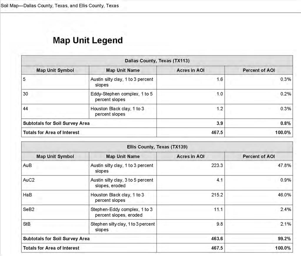
46 GEOTECHNICAL DATA SOIL SURVEY DATA & MAP SECTION ACRES SECTION 2A ACRES SECTION 2B ACRES SECTION ACRES WALTON GLOBAL HOLDINGS ACRES
47
48

49 SITE DEVELOPMENT & ANALYSIS
50 404 DELINEATION SECTION404OFTHECLEANWATERACTESTABLISHEDAPROGRAMTOREGULATETHE DISCHARGE OF DREDGED OR FILL MATERIAL INTO WATERS OF THE UNITED STATES, INCLUDING WETLANDS. THE PROGRAM IS JOINTLY ADMINISTERED BY THE U.S. ARMY CORPS OF ENGINEERS (CORPS OR USACE) AND THE ENVIRONMENTAL PROTECTION AGENCY (EPA). A DESKTOP REVIEW WAS CONDUCTED. A DESKTOP REVIEW INVOLVES REVIEW OF READILY AVAILABLE ONLINE MAPPING TO REASONABLY APPROXIMATE ANY POTENTIAL WATERS OF THE U.S. USGS TOPOGRAPHIC MAPS HAVE BEEN REVIEWED ALONG WITH USDA SOILS MAPS, AERIAL PHOTOGRAPHY, FEMA FIRMETTEMAPS AND THE NATIONAL WETLANDS INVENTORY MAPS TO ARRIVE AT THE FOLLOWING CONCLUSIONS FOR EACH TRACT: (Source: Kimley Horn & Associates. Industrial Property Study. June 2015)
51 SITE DEVELOPMENT ANALYSIS SECTION 1 SECTION 1 NO PORTION OF SECTION 1 ( TRACT 1 ) APPEARS TO BE WITHIN THE DESIGNATED 100 YEAR FLOODPLAIN. THERE IS ALSO NO INDICATION THAT AQUATIC FEATURES THAT HAVE THE POTENTIAL TO BE WATERS OF THE U.S. ARE PRESENT ON TRACT 1. SECTION 1 BASED ON THIS REVIEW WE FEEL THAT DEVELOPMENT CAN OCCUR ON TRACT 1 WITHOUT INITIATING USACE COORDINATION OR PERMITTING. (Source: Kimley Horn & Associates. Industrial Property Study. June 2015)
52 SITE DEVELOPMENT ANALYSIS SECTION 2 SECTION 2 SECTION 2 NO PORTION OF TRACT 2 APPEARS TO BE WITHIN THE DESIGNATED 100 YEAR FLOODPLAIN. THERE IS INDICATION HOWEVER THAT AQUATIC FEATURES THAT HAVE THE POTENTIAL TO BE WATERS OF THE U.S. ARE PRESENT, IN THE FORM OF TWO MAPPED STREAM CHANNELS. RECENTANDHISTORICAERIALS,ASWELLASTHEUSGSTOPO MAP AND NATIONAL HYDROGRAPHIC DATABASE, SHOW AN UN NAMED TRIBUTARY TO BEAR CREEK BEGINNING NEAR THE SOUTHWESTERN EDGE OF TRACT 2 AND FLOWING TO THE NORTHEAST. THIS MAPPED STREAM CHANNEL FLOWS OFF SITE THROUGH BOX CULVERTS PLACED UNDER THE ADJACENT RAILROAD TRACKS AND SH 342. A SECOND STREAM APPEARS TO ORIGINATE IN THE WALTON TRACT AND FLOWS NORTH TO MERGE WITH THE FIRST IDENTIFIED STREAM IN THE MIDDLE OFTRACT2.ITISLIKELYTHATTHESESTREAMREACHESAREOF AN EPHEMERAL HYDROLOGIC REGIME. THE READILY AVAILABLE MAPPING DOES NOT INDICATE THE LIKELY PRESENCE OF ADJACENT OR FRINGE WETLANDS. IT IS OUR OPINION THAT THESE UN NAMED REACHES TO BEAR CREEK WOULD BE CONSIDERED WATERS OF THE U.S. BASED ON THIS REVIEW WE RECOMMEND A SITE VISIT BY A QUALIFIED WETLAND SCIENTIST TO MAKE OBSERVATIONS ON TRACT 2 AND COORDINATE WITH THE USACE IF DETERMINED NECESSARY. IF THESE REACHES ARE CONFIRMED TO BE WATERS OF THE U.S., IMPACTS COULD BE PERMITTED AS DETAILED IN THE USACE PERMITTING SECTION BELOW. (Source: Kimley Horn & Associates. Industrial Property Study. June 2015)
53 SITE DEVELOPMENT ANALYSIS SECTION 3 SECTION 3 SECTION 3 NO PORTION OF SECTION 3 ( TRACT 3 ) APPEARS TO BE WITHIN THE 100 YEAR FLOODPLAIN. THERE IS INDICATION HOWEVER THAT AQUATIC FEATURES THAT HAVE THE POTENTIAL TO BE WATERS OF THE U.S. ARE PRESENT ON THE SITE, IN THE FORM OF A POSSIBLE STREAM CHANNEL AND KNOWN IMPOUNDMENT. RECENT AND HISTORIC AERIALS, AS WELL AS THE USGS TOPO MAP AND NATIONAL HYDROGRAPHIC DATABASE, SHOW A POSSIBLE UN NAMED TRIBUTARY TO BEAR CREEK BEGINNING NEAR THE SOUTHERN EDGE OF THE SITE AND FLOWING TO THE NORTHEAST. THIS POSSIBLE STREAM CHANNEL FLOWS OFF SITE THROUGH A THICK CANOPY OF TREES. IT IS LIKELY THAT THIS DRAINAGE FEATURE WOULD BE CONSIDERED AN UPLAND DITCH OR SWALE AND WOULD NOT BE CONSIDERED WATERS OF THE U.S. UNDER THE CURRENT GUIDANCE. A SITE VISIT SHOULD BE CONDUCTED TO VERIFY THE CURRENT STATE OF THIS DRAINAGE AND THE PROPER CATEGORIZATION OF THESE FEATURES. READILY AVAILABLE MAPPING ALSO INDICATES A SMALL IMPOUNDMENT OR UPLAND TANK LOCATED NEAR THE SOUTHERN BOUNDARY OF THE SITE. IT IS LIKELY THAT THIS IS AN UPLAND STOCK TANK, HISTORICALLY USED FOR AGRICULTURAL PURPOSES AND WOULD BE CONSIDERED ISOLATED UNDER CURRENT GUIDANCE AND NOT WATERS OF THE US. (Source: Kimley Horn & Associates. Industrial Property Study. June 2015)
54 SITE DEVELOPMENT ANALYSIS SECTION 4 SECTION 4 SECTION 4 TO SUMMARIZE THE DELINEATION, TWO TRIBUTARIES WERE IDENTIFIED WITHIN THE PROJECT SITE. BASED ON THE JUNE 2007 GUIDANCE, IT IS IES PROFESSIONAL OPINION THAT THE USACE WOULD DETERMINE THAT TRIBUTARY 1 AND TRIBUTARY 2 WOULD MEET A DEFINITION OF A WATER OF THE UNITED STATES. THIS OPINION IS BASED ON THE FEATURES LOCATION WITHIN THE LANDSCAPE AND THE HISTORIC EVIDENCE OF THE PREVIOUSLY EXISTING FEATURE WITHIN THE PROJECT SITE. AS SUCH, TRIBUTARY 1 AND TRIBUTARY 2 WOULD BE CONSIDERED A WATER OF THE UNITED STATES AND DISCHARGES INTO THIS CHANNEL WOULD BE REGULATED UNDER SECTION 404 OF THE CWA. THIS DELINEATION IS BASED ON PROFESSIONAL EXPERIENCE IN THE APPROVED METHODOLOGY AND FROM EXPERIENCE WITH THE USACE FORT WORTH DISTRICT REGULATORY BIOLOGISTS; HOWEVER, THIS DELINEATION DOES NOT CONSTITUTE A JURISDICTIONAL DETERMINATION OF WATERS OF THE UNITED STATES. ONLY THE USACE CAN MAKE THE FINAL JURISDICTIONAL DETERMINATION, WHICH CAN BE BASED ON THE PROFESSIONAL OPINIONS PRESENTED IN THIS REPORT. (Source: Integrated Environmental Solutions, LLC. Waters of the US Determination Study. November 2014)
55 USACE PERMITTING IF PROPOSED ACTIVITIES CONDUCTED ON TRACT 2 OR 3 DO NOT IMPACT WATERS OF THE US, NO PERMIT OR COORDINATION WITH THE CORPS WOULD BE REQUIRED. HOWEVER, IF THE STREAMS ARE CONFIRMED TO BE WATERS OF THE US AND IMPACTS ARE PROPOSED, POTENTIAL CORPS PERMITTING STRATEGIES FOR DEVELOPMENT ON THESE TRACT INCLUDE COVERAGE BY ONE OR MORE OF THE FOLLOWING OPTIONS: NATIONWIDE PERMIT (NWP) OR, STANDARD INDIVIDUAL PERMIT (SIP). NATIONWIDE PERMITS ARE GENERALLY LESS CHALLENGING TO OBTAIN THAN A SIP, AND GENERALLY ALLOW FOR IMPACTS TO WATERS OF THE US THAT DO NOT EXCEED 0.5 ACRE IN AREA OR EXCEED 300 LINEAR FEET OF ANY STREAM BED. THE LINEAR FOOT LIMIT CAN BE WAIVED AT THE DISCRETION OF THE CORPS FOR LOW QUALITY EPHEMERAL AND INTERMITTENT STREAMS. THE QUALITY OF THE STREAM SHOULD BE ASSESSED DURING A SITE VISIT BY A QUALIFIED WETLAND SCIENTIST. NATIONWIDE PERMITS ONLY AUTHORIZE SINGLE AND COMPLETE PROJECTS. EACH SINGLE AND COMPLETE PROJECT MUST SHOW INDEPENDENT UTILITY. A PROJECT IS CONSIDERED TO HAVE INDEPENDENT UTILITY BY THE CLEAN WATER ACT IF IT WOULD BE CONSTRUCTED ABSENT THE CONSTRUCTION OF OTHER PROJECTS IN THE PROJECT AREA. PORTIONS OF A MULTI PHASE PROJECT THAT DEPEND UPON OTHER PHASES OF THE PROJECT DO NOT HAVE INDEPENDENT UTILITY. PHASES OF A PROJECT THAT WOULD BE CONSTRUCTED EVEN IF THE OTHER PHASES WERE NOT BUILT CAN BE CONSIDERED AS SEPARATE SINGLE AND COMPLETE PROJECTS WITH INDEPENDENT UTILITY. NOTIFICATION TO THE CORPS TYPICALLY RESULTS IN A REQUIREMENT TO PROVIDE COMPENSATORY MITIGATION FOR UNAVOIDABLE IMPACTS TO WATERS OF THE US. COMPLETELY AVOIDING IMPACTS TO WATERS OF THE US WOULD RESULT IN NOT HAVING TO NOTIFY THE CORPS. NOTIFICATION WILL REQUIRE A DETAILED PROPOSED JURISDICTIONAL DETERMINATION AND A COMPLETE PRECONSTRUCTION NOTIFICATION PACKAGE (PCN). AS AN EXAMPLE, NWP 39 (COMMERCIAL AND INSTITUTIONAL DEVELOPMENTS) AUTHORIZES THE DISCHARGES OF DREDGED OR FILL MATERIAL FOR THE CONSTRUCTION OR EXPANSION OF COMMERCIAL AND INSTITUTIONAL BUILDING FOUNDATIONS AND BUILDING PADS AND ATTENDANT FEATURES THAT ARE NECESSARY FOR THE USE AND MAINTENANCE OF THE STRUCTURES. DISCHARGES CANNOT CAUSE THE LOSS OF GREATER THAN 0.5 ACRE OF WATERS OF THE US OR MORE THAN 300 LINEAR FEET OF STREAM BED. A PCN IS REQUIRED TO BE SUBMITTED TO THE CORPS FOR THIS PERMIT. ACTIVITIES WITH IMPACTS BEYOND THE NWP THRESHOLDS MAY BE AUTHORIZED THROUGH A STANDARD INDIVIDUAL PERMIT. A SIP REQUIRES EXTENSIVE OFF SITE ALTERNATIVES ANALYSIS, RESOURCE AGENCY REVIEW, AND A PUBLIC NOTICE AMONG ADDITIONAL REQUIREMENTS BEYOND THOSE OF A NWP. PRELIMINARY OBSERVATIONS INDICATE THAT OPPORTUNITIES FOR ON SITE, IN KIND MITIGATION DO EXIST. THE MAJORITY OF THESE OPPORTUNITIES EXIST IN THE FORM OF RELOCATION OF EXISTING STREAMS ALONG THE PROPERTY BOUNDARY. IMPACTS TO AQUATIC FEATURES THAT CANNOT BE COMPENSATED FOR ON SITE, CAN GENERALLY BE COMPENSATED FOR THROUGH THE PURCHASE OF MITIGATION BANK CREDITS. IT IS ALSO IMPORTANT TO KEEP IN MIND THAT WITH THE 2008 FINAL MITIGATION RULE, THE CORPS PREFERS THE PURCHASE OF BANK CREDITS OVER ON SITE MITIGATION FOR UNAVOIDABLE IMPACTS TO AQUATIC RESOURCES. OUR LOCAL DISTRICT, FORT WORTH, HAS IMPLEMENTED WHAT IS LOCALLY CALLED THE RULE. WITH THAT RULE 50% OF THE NECESSARY STREAM MITIGATION CAN BE PURCHASED FROM AN OLDER LEGACY BANK GENERALLY AT A LOWER COST AND THE OTHER 50% HAS TO BE PURCHASED IN ACCORDANCE WITH THE RULE WITH IN KIND BANKING ACTIVITIES (TXRAM), GENERALLY AT A HIGHER PRICE. UNTIL A DETAILED JURISDICTION DETERMINATION IS PERFORMED, WHICH REQUIRES ONSITE INVESTIGATION, IT IS DIFFICULT TO ESTIMATE MITIGATION CREDITS THAT MAY BE NEEDED. (Source: Kimley Horn & Associates)

56
YOUR GATEWAY TO GLOBAL DISTRIBUTION
 YOUR GATEWAY TO GLOBAL DISTRIBUTION INDUSTRIAL DEVELOPMENT SITE DLH PARCEL #44 9.954 GROSS ACRES DLH PARCEL #45 10.83 GROSS ACRES DLH PARCEL #47C 5.7+/- GROSS ACRES 4300 TELEPHONE ROAD DALLAS, TEXAS T
YOUR GATEWAY TO GLOBAL DISTRIBUTION
 YOUR GATEWAY TO GLOBAL DISTRIBUTION INDUSTRIAL DEVELOPMENT SITE DLH PARCEL #44 9.954 GROSS ACRES DLH PARCEL #45 10.83 GROSS ACRES DLH PARCEL #47C 5.7+/- GROSS ACRES 4300 TELEPHONE ROAD DALLAS, TEXAS T
DEVELOPMENT REPORT UNION PACIFIC PROPERTY SAN ANTONO INTERMODAL YARD AREA
 DEVELOPMENT REPORT UNION PACIFIC PROPERTY SAN ANTONO INTERMODAL YARD AREA This report was prepared to present development information (Utility availability, Development Regulations, Flood Plain information,
SECONDARY WETLAND IMPACTS ANALYSIS
 SECONDARY WETLAND IMPACTS ANALYSIS USACE File. SWG-2012-00153 During the development of the Grand Parkway (State Highway 99) Segments H and I-1 from United States Highway 59/Interstate Highway 69 N to
I THOUGHT IT WAS JUST WET LAND: A GUIDE TO ENVIRONMENTAL PERMITTING FOR AIRPORTS ROAD SCHOOL 2018 SIMON DAVIES, SENIOR SCIENTIST MARCH 7, 2018
 I THOUGHT IT WAS JUST WET LAND: A GUIDE TO ENVIRONMENTAL PERMITTING FOR AIRPORTS ROAD SCHOOL 2018 SIMON DAVIES, SENIOR SCIENTIST MARCH 7, 2018 Definition Regulatory Definition - Those areas that are inundated
Floodplain Jurisdiction 6/9/2014. Texas Floodplain Management Association May 29, 2014
 Texas Floodplain Management Association May 29, 2014 Loretta E Mokry, PWS Craig T. Maske, P.E., CFM Alan Plummer Associates, Inc. Who really owns the floodplain? What do I have to do to use/develop the
Once known as warehousing and distribution, the process
 Map III-2.3 Proposed Agile Port Industrial Area AGILE PORT INDUSTRIAL AREA PLAN Once known as warehousing and distribution, the process of moving goods to market has evolved dramatically. No longer is
(TXRAM) Overview and Applications Strategies. John Wooten James A. Thomas, PWS, CWB
 Overview and Applications Strategies. John Wooten James A. Thomas, PWS, CWB") Click Texas to Rapid edit Master Assessment title style Method (TXRAM) Overview and Applications Strategies John Wooten James A. Thomas, PWS, CWB Overview Need, Purpose and Objectives for Texas Rapid Assessment
Click Texas to Rapid edit Master Assessment title style Method (TXRAM) Overview and Applications Strategies John Wooten James A. Thomas, PWS, CWB Overview Need, Purpose and Objectives for Texas Rapid Assessment
U.S. Army Corps of Engineers Permit Application Tips
 U.S. Army Corps of Engineers Permit Application Tips MnDOT Environmental Conference Ben Orne and Sarah Wingert, USACE 4-29-2015 US Army Corps of Engineers BUILDING STRONG Outline Introduction to Corps
Information for File # RJH
 Information for File #2011-01629-RJH Applicant: Matthew Ternes Corps Contact: Ryan Huber, U. S. Army Corps of Engineers, 211 North Broadway, Suite 221, Green Bay, Wisconsin 54303; ryan.j.huber@usace.army.mil;
Public Notice. Permit Application No.: SWF Date: December 20, 2012
 Public Notice Applicant: The City of The Colony Permit Application No.: SWF-2012-00231 Date: December 20, 2012 The purpose of this public notice is to inform you of a proposal for work in which you might
Project Information. Pursuant to Section 404 of the Clean Water Act (33 U.S. Code 1344), notice is hereby given that
, notice is hereby given that") US ARMY Corps Of Engineers Little Rock District JOINT PUBLIC NOTICE CORPS OF ENGINEERS STATE OF ARKANSAS Application Number: 2014-00083-1 Date: December 22, 2014 Comments Due: January 16, 2015 TO WHOM
US ARMY Corps Of Engineers Little Rock District JOINT PUBLIC NOTICE CORPS OF ENGINEERS STATE OF ARKANSAS Application Number: 2014-00083-1 Date: December 22, 2014 Comments Due: January 16, 2015 TO WHOM
PRESENTERS. Contact Information: RW Armstrong Union Station, 300 S. Meridian St. Indianapolis, IN
 1 PRESENTERS David Bourff, Director of Environmental Planning Simon Davies, LEED AP, Environmental Scientist Summer O Brien, PWS, Senior Environmental Scientist Contact Information: RW Armstrong Union
Corps Regulatory Program Jurisdiction and Permits
 Corps Regulatory Program Jurisdiction and Permits Council of Texas Archeologists Meeting Austin, TX April 2018 Jimmy Barrera Regulatory Archeologist/Project Manager Fort Worth District US Army Corps of
 December 5, 2016 The Honorable Anthony R. Foxx Secretary U.S. Department of Transportation 1200 New Jersey Avenue SE Washington, DC 20590 RE: TxDOT s FY2017 FASTLANE application for Grand Parkway Dear
Attachment C Applicant s Proposed Mitigation Statement Alaska DOT&PF Northern Region Pilot Station Airport Relocation Project POA
 Attachment C Applicant s Proposed Mitigation Statement Alaska DOT&PF Northern Region Pilot Station Airport Relocation Project POA-2004-1223 Introduction This mitigation statement was prepared as an attachment
INDUSTRIAL OUTPARCELS AVAILABLE WITH RAIL ACCESS BUILD TO SUIT OPTIONS. The Moser Group, Inc.
 INDUSTRIAL OUTPARCELS AVAILABLE WITH RAIL ACCESS BUILD TO SUIT OPTIONS Jan Ringeling Broker (704) 490-3872 jringeling@themosergroupinc.com The Moser Group, Inc. Indian Trail, North Carolina 28079 phone:
CITY OF ANGLETON MASTER DRAINAGE PLAN PHASE I EVALUATION & PRELIMINARY REPORT
 CITY OF ANGLETON MASTER DRAINAGE PLAN PHASE I EVALUATION & PRELIMINARY REPORT February 2008 Prepared by STOKES & ASSOCIATES, INC. 605 South Main Street, Suite 200 Henderson, Texas 75654 903-657-7558 TABLE
U.S. Army Corps of Engineers Water Resources Regulatory Program: Emergency Stream Restoration
 U.S. Army Corps of Engineers Water Resources Regulatory Program: Emergency Stream Restoration Margaret Crawford Biologist Auburn Field Office June 3, 2014 US Army Corps of Engineers Section 10 of the Rivers
Pullman Airport Expansion Permitting Process Overview, Wetlands and Mitigation. October 25, 2017
 Pullman Airport Expansion Permitting Process Overview, Wetlands and Mitigation October 25, 2017 Overview of the Airport Project The Pullman Airport Expansion Project includes: Realignment of Runway 6/24
Submitted to: Mr. Jim Dunn Chesterfield County Economic Development Department 9401 Courthouse Road - Suite B Chesterfield, VA 23830
 THE TIMMONS REPORT Draft Executive Summary of Preliminary Engineering, Environmental and Master Planning Report for Meadowville Technology Park Chesterfield County, Virginia Submitted to: Mr. Jim Dunn
John Rapanos. Goals For Today. 1. Review Background 2. Introduce Case Studies/Examples. 3. Summarize Current Guidance 4. Predict the Future..
 John Rapanos Rapanos Decision A Divided Court Rapanos v. United States, 547 U.S., 126 S. Ct. 2208, 165 L. Ed. 2d 159 (2006). Goals For Today 1. Review Background 2. Introduce Case Studies/Examples a. Cundiff
Potentially jurisdictional waters and/or wetlands were assessed within the review area and determined to be not jurisdictional. Explain:.
 Potentially jurisdictional waters and/or wetlands were assessed within the review area and determined to be not jurisdictional. Explain:. For each wetland, specify the following: Directly abuts? (Y/N)
US Army Corps of Engineers and Stream Restoration Permitting
 US Army Corps of Engineers and Stream Restoration Permitting Jack Dinne US Army Corps of Engineers-Baltimore Maryland Section Northern May 6, 2014 US Army Corps of Engineers Presentation Overview Corps
INTEGRATING FREIGHT IN CORRIDOR PLANNING AND PROJECT DEVELOPMENT. Steve Linhart, AICP Caroline Mays, AICP
 INTEGRATING FREIGHT IN CORRIDOR PLANNING AND PROJECT DEVELOPMENT Steve Linhart, AICP Caroline Mays, AICP June 17, 2016 The Importance of Freight Transportation in Texas Almost 4 billion tons of freight
Drainage Report. New Braunfels Municipal Airport. Master Plan Update 2005
 Drainage Report Master Plan Update 2005 General The Texas Department of Transportation (TxDOT), Aviation Division, retained the consulting engineering team of Parkhill, Smith & Cooper, Inc. (PSC), to prepare
TxDOT Environmental Conference September 14, 2016 Session 8 Policy Update and Current Issues in Natural Resources
 TxDOT Environmental Conference September 14, 2016 Session 8 Policy Update and Current Issues in Natural Resources By Sharon Mattox Sharon M. Mattox PLLC ISSUES Status of regulation defining Waters of the
LOOP 9 SOUTHEAST WELCOME TO THE LOOP 9 CORRIDOR/FEASIBILITY STUDY. Presentation 6:30 p.m. to 7:00 p.m.
 1 WELCOME TO THE LOOP 9 CORRIDOR/FEASIBILITY STUDY PUBLIC MEETINGS Open House 5:30 p.m. to 6:30 p.m. Presentation 6:30 p.m. to 7:00 p.m. Open House 7:00 p.m. to 8:00 p.m. Tuesday, September 24, 2013 Thursday,
 Page 1 of 5 APPROVED JURISDICTIONAL DETERMINATION FORM U.S. Army Corps of Engineers SECTION I: BACKGROUND INFORMATION A. REPORT COMPLETION DATE FOR APPROVED JURISDICTIONAL DETERMINATION (JD): 09-Dec-2014
USACE 2017 Nationwide Permits An Overview
 USACE 2017 Nationwide Permits An Overview Tarrant County Bar Association Environmental Section Fort Worth, TX March 7, 2017 Chandler Peter Technical Specialist Regulatory Division Fort Worth District US
Public Notice. Public Notice No. Date: Closing Date: US Army Corps LRL mad 6 Apr May 2018 of Engineers Louisville District
 Public Notice Public Notice No. Date: Closing Date: US Army Corps LRL-2016-1083-mad 6 Apr 2018 7 May 2018 of Engineers Louisville District Please address all comments and inquiries to: U.S. Army Corps
Interstate 73 FEIS: I-95 to the Myrtle Beach Region Chapter 4. Public Involvement and Agency Coordination
 4-65 Interstate 73 FEIS: I-95 to the Myrtle Beach Region 4-66 Comment noted. The use of existing roadways was considered during alternative development (refer to Chapter 2, Section 2.1, page 2-1 and the
B. CHARACTERISTICS OF TRIBUTARY (THAT IS NOT A TNW) AND ITS ADJACENT WETLANDS (IF ANY):
 AND ITS ADJACENT WETLANDS (IF ANY):") SECTION III: CWA ANALYSIS A. TNWs AND WETLANDS ADJACENT TO TNWs The agencies will assert jurisdiction over TNWs and wetlands adjacent to TNWs. If the aquatic resource is a TNW, complete Section III.A.1
SECTION III: CWA ANALYSIS A. TNWs AND WETLANDS ADJACENT TO TNWs The agencies will assert jurisdiction over TNWs and wetlands adjacent to TNWs. If the aquatic resource is a TNW, complete Section III.A.1
APPROVED JURISDICTIONAL DETERMINATION FORM U.S. Army Corps of Engineers. Folder UTM List UTM list determined by folder location NAD83 / UTM zone 37S
 APPROVED JURISDICTIONAL DETERMINATION FORM U.S. Army Corps of Engineers SECTION I: BACKGROUND INFORMATION A. REPORT COMPLETION DATE FOR APPROVED JURISDICTIONAL DETERMINATION (JD): 06-Jan-2009 B. DISTRICT
https://orm.usace.army.mil/orm2/f?p=106:34: ::no::
 Page 1 of 7 APPROVED JURISDICTIONAL DETERMINATION FORM U.S. Army Corps of Engineers SECTION I: BACKGROUND INFORMATION A. REPORT COMPLETION DATE FOR APPROVED JURISDICTIONAL DETERMINATION (JD): 26-Dec-2013
Ditches in North Carolina
 Ditches in North Carolina Raleigh Bland Regulatory Project Manager Washington Regulatory Field Office February 11, 2016 US Army Corps of Engineers Army Corps of Engineers Standard Operating Procedures
GULF COAST RAIL DISTRICT VISION FOR REGIONAL RAIL
 GULF COAST RAIL DISTRICT VISION FOR REGIONAL RAIL OCTOBER 2014 Cover photographs courtesy of Top left - Mike Bates TABLE OF CONTENTS MISSION... 1 INTRODUCTION... 1 VISION STATEMENT... 1 BACKGROUND... 2
U.S. Army Corps of Engineers (USACE) Galveston District
 Galveston District") Appendix II U.S. Army Corps of Engineers (USACE) Galveston District SWG MITIGATION BANK PROSPECTUS TEMPLATE This Template includes the information required for a mitigation bank prospectus as outlined
Appendix II U.S. Army Corps of Engineers (USACE) Galveston District SWG MITIGATION BANK PROSPECTUS TEMPLATE This Template includes the information required for a mitigation bank prospectus as outlined
USACE Regulatory Program Ongoing Developments
 USACE Regulatory Program Ongoing Developments Society of Texas Environmental Professionals Fort Worth, TX January 24, 2018 Chandler Peter Technical Specialist Regulatory Division Fort Worth District US
Public Notice. US Army Corps of Engineers Fort Worth District. Applicant: Mill Branch Stream Mitigation Bank. Permit Application No.
 Public Notice US Army Corps of Engineers Fort Worth District Applicant: Mill Branch Stream Mitigation Bank Permit Application No.: Date: November 10, 2010 The purpose of this public notice is to inform
Potentially jurisdictional waters and/or wetlands were assessed within the review area and determined to be not jurisdictional.
 Potentially jurisdictional waters and/or wetlands were assessed within the review area and determined to be not jurisdictional. Explain: -2- SECTION III: CWA ANALYSIS A. TNWs AND WETLANDS ADJACENT TO TNWs
Navigating Section 404 Clean Water Act Permitting
 Navigating Section 404 Clean Water Act Permitting 2012 Salt Lake Countywide Watershed Symposium September 26, 2012 US Army Corps of Engineers What does this percentile represent? a) Percentage of wetlands
Prime Pointe. 3,000 acre Master Planned for Manufacturing & Distribution. at the center of North American Logistics And Dallas County Inland Port
 3,000 acre Master Planned for Manufacturing & Distribution North American Logistics And Distribution Multiple Sites for 1+ MSF Buildings Manufacturing Large Sites with Redundant Power Prime 45 Development,
Public Notice No Metropolitan Avenue Charlotte, North Carolina 27204
 Public Notice US Army Corps of Engineers Louisville District Public Notice No. Open Date: Close Date: LRL-2016-239--mck 16 Mar 2016 15 Apr 2016 Please address all comments and inquiries to: U.S. Army Corps
Instructions for the South Pacific Division Nationwide Permit Pre- Construction Notification (PCN):
:") This PCN integrates the requirements of the U.S. Army Corps of Engineers (Corps) Nationwide Permit Program within the South Pacific Division (SPD), including the Albuquerque, Los Angeles, San Francisco,
This PCN integrates the requirements of the U.S. Army Corps of Engineers (Corps) Nationwide Permit Program within the South Pacific Division (SPD), including the Albuquerque, Los Angeles, San Francisco,
Information Paper Flood Recovery and Repair Activities in the Galveston District, U.S. Army Corps of Engineers
 U.S. Army Corps Of Engineers Galveston District Information Paper Flood Recovery and Repair Activities in the Galveston District, U.S. Army Corps of Engineers U.S. ARMY CORPS OF ENGINEERS, GALVESTON DISTRICT
Public Notice. Applicant: Texas Central Railroad, LLC Project No.: SWF Date: December 22, 2017
 Public Notice Applicant: Texas Central Railroad, LLC Project No.: SWF-2011-00483 Date: December 22, 2017 The purpose of this public notice is to inform you of a proposal for work in which you might be
Public Notice ISSUED: 20-JAN-2016 EXPIRES: 19-FEB-2016
 APPLICANT: Shakopee Mdewakanton Sioux Community Public Notice ISSUED: 20-JAN-2016 EXPIRES: 19-FEB-2016 REFER TO: MVP-2015-04726-RMM SECTION: 404 - Clean Water Act 1. APPLICATION FOR PERMIT TO discharge
Public Notice U.S. ARMY CORPS OF ENGINEERS, GALVESTON DISTRICT AND TEXAS COMMISSION ON ENVIRONMENTAL QUALITY
 Public Notice U.S. Army Corps Permit Application No: SWG-2007-01866 Of Engineers Date Issued: 13 March 2018 Galveston District Comments Due: 12 April 2018 U.S. ARMY CORPS OF ENGINEERS, GALVESTON DISTRICT
Department of Army Permitting Process: Dredging
 Department of Army Permitting Process: Dredging Elizabeth Shelton Regulatory Specialist Regulatory Division USACE Galveston District Dredging Your Docks Seminar - 2015 Corpus Christi, Texas October 8,
 Page 1 of 5 APPROVED JURISDICTIONAL DETERMINATION FORM U.S. Army Corps of Engineers SECTION I: BACKGROUND INFORMATION A. REPORT COMPLETION DATE FOR APPROVED JURISDICTIONAL DETERMINATION (JD): 02-Nov-2012
Waters of the U.S. Revisions
 City and County of Denver January 12 2015 Denver International Airport Waters of the U.S. Revisions Sarah Reeves, Brown and Caldwell Waters of the US (WOTUS) Clean Water Act... protects waters to keep
Clean Water Act Regulatory Program
 Clean Water Act Regulatory Program New Mexico Floodplain Managers Association Conference Deanna L. Cummings April 12, 2018 US Army Corps of Engineers Introduction Clean Water Act Section 404 USACE Jurisdiction
Public Notice. This notice announces an application submitted for a Department of the Army (DA) Permit, subject to Section 404 of the Clean Water Act:
 Permit, subject to Section 404 of the Clean Water Act:") Public Notice US Army Corps of Engineers Louisville District Public Notice No. Date: 14 Dec 2018 Closing Date: 14 Jan 2018 Please address all comments and inquiries to: U.S. Army Corps of Engineers, Louisville
Public Notice US Army Corps of Engineers Louisville District Public Notice No. Date: 14 Dec 2018 Closing Date: 14 Jan 2018 Please address all comments and inquiries to: U.S. Army Corps of Engineers, Louisville
U.S. ARMY CORPS OF ENGINEERS BUILDING STRONG LOS ANGELES DISTRICT
 PUBLIC NOTICE U.S. ARMY CORPS OF ENGINEERS BUILDING STRONG LOS ANGELES DISTRICT APPLICATION FOR PERMIT Gate King Properties, LLC Tract 50283 Public Notice/Application No.: SPL-2011-01067-GS Project: Gate
 Page 1 of 5 APPROVED JURISDICTIONAL DETERMINATION FORM U.S. Army Corps of Engineers SECTION I: BACKGROUND INFORMATION A. REPORT COMPLETION DATE FOR APPROVED JURISDICTIONAL DETERMINATION (JD): 10-Oct-2013
Information for File # ARC
 Information for File # 2015-02993-ARC Applicant Corps Contact St. Louis-Lake Counties Regional Rail Authority Andrew R. Chambers Address 600 South Lake Avenue, Suite 211, Duluth, MN 55802 E-Mail Andrew.R.Chambers@usace.army.mil
 Page 1 of 6 APPROVED JURISDICTIONAL DETERMINATION FORM U.S. Army Corps of Engineers SECTION I: BACKGROUND INFORMATION A. REPORT COMPLETION DATE FOR APPROVED JURISDICTIONAL DETERMINATION (JD): 29-Apr-2015
Regulatory Program. SECTION I: BACKGROUND INFORMATION A. COMPLETION DATE FOR APPROVED JURISDICTIONAL DETERMINATION (JD): March 04, 2019
: March 04, 2019") Regulatory Program APPROVED JURISDICTIONAL DETERMINATION FORM U.S. Army Corps of Engineers This form should be completed by following the instructions provided in the Approved Jurisdictional Determination
Regulatory Program APPROVED JURISDICTIONAL DETERMINATION FORM U.S. Army Corps of Engineers This form should be completed by following the instructions provided in the Approved Jurisdictional Determination
STATE OF WASHINGTON FINAL DECISIONS AND SECTION 401 WATER QUALITY CERTIFICATION CONDITIONS FOR THE CORPS OF ENGINEERS 2017 NATIONWIDE PERMIT PROGRAM
 STATE OF WASHINGTON FINAL DECISIONS AND SECTION 401 WATER QUALITY CERTIFICATION CONDITIONS FOR THE CORPS OF ENGINEERS 2017 NATIONWIDE PERMIT PROGRAM In addition to all the U.S. Army Corps of Engineers
 Page 1 of 6 APPROVED JURISDICTIONAL DETERMINATION FORM U.S. Army Corps of Engineers SECTION I: BACKGROUND INFORMATION A. REPORT COMPLETION DATE FOR APPROVED JURISDICTIONAL DETERMINATION (JD): 29-Apr-2015
DEPARTMENT OF THE ARMY U.S. ARMY CORPS OF ENGINEERS - MOBILE DISTRICT BIRMINGHAM FIELD OFFICE 218 SUMMIT PARKWAY, SUITE 222 HOMEWOOD, AL 35209
 DEPARTMENT OF THE ARMY U.S. ARMY CORPS OF ENGINEERS - MOBILE DISTRICT BIRMINGHAM FIELD OFFICE 218 SUMMIT PARKWAY, SUITE 222 HOMEWOOD, AL 35209 CESAM-RD-I-N December 7, 2012 PUBLIC NOTICE NO. SAM-2012-01506-LCB
± Legend. Tower 55. Trinity Railway Express Fort Worth & Western Railroad. UP Railroad BNSF Railway
 Blue Skyways Collaborative Annual Meeting San Antonio, TX October 30, 2008 North Central Texas Council of Governments Transportation Department ± Legend Tower 55 UP Railroad BNSF Railway Trinity Railway
SECTION I: BACKGROUND INFORMATION
 APPROVED JURISDICTIONAL DETERMINATION FORM U.S. Army Corps of Engineers SECTION I: BACKGROUND INFORMATION A. REPORT COMPLETION DATE FOR APPROVED JURISDICTIONAL DETERMINATION (JD): 03-Dec-2012 B. DISTRICT
Public Notice. Applicant: Lennar Homes Project No.: SWF Date: October 29, Name: Mr. Darvin Messer Phone Number:
 Public Notice Applicant: Lennar Homes Project No.: SWF-2013-00265 Date: October 29, 2013 The purpose of this public notice is to inform you of a proposal for work in which you might be interested. It is
Regulatory Program. SECTION I: BACKGROUND INFORMATION A. COMPLETION DATE FOR APPROVED JURISDICTIONAL DETERMINATION (JD): September 23, 2015
: September 23, 2015") Regulatory Program APPROVED JURISDICTIONAL DETERMINATION FORM U.S. Army Corps of Engineers This form should be completed by following the instructions provided in the Approved Jurisdictional Determination
Regulatory Program APPROVED JURISDICTIONAL DETERMINATION FORM U.S. Army Corps of Engineers This form should be completed by following the instructions provided in the Approved Jurisdictional Determination
RIDGE LOGISTICS CENTER.
 RIDGE LOGISTICS CENTER www.ridgelogisticscenter.com RIDGE LOGISTICS CENTER is located off Dallas Avenue in the city of Dallas, about one mile south of I-20, equidistant from I-35E and I-45. This 125-acre
Public Notice. Applicant: TXI Operating, LP Project No.: SWF Date: April 2, Name: Mr. Darvin Messer Phone Number:
 Public Notice Applicant: TXI Operating, LP Project No.: SWF-2012-00125 Date: April 2, 2013 The purpose of this public notice is to inform you of a proposal for work in which you might be interested. It
±230 ACRES AVAILABLE FOR SALE
 ±230 ACRES AVAILABLE FOR SALE HOUSTO AUSTI SA ATOIO CORPUS CHRISTI ROCKPORT TERMIALS LAD AVAILABLE FOR SALE OFFERIG AI Partners is pleased to exclusively offer a unique and strategically located ±230 acre
Project No.: From: Chelsea Martin, Environmental Scientist; and Adam R. Crary, PWS, PWD. Preliminary Wetland Impact Analysis
 Transportation Land Development Environmental Energy S e r v i c e s 7056 US Route 7 Post Office Box 120 North Ferrisburgh, Vermont 05473 802.497.6100 Fax 802.425.7799 Memorandum To: NECPL Project File
SECTION I: BACKGROUND INFORMATION
 1 of 8 6/17/2008 1:05 PM APPROVED JURISDICTIONAL DETERMINATION FORM U.S. Army Corps of Engineers SECTION I: BACKGROUND INFORMATION A. REPORT COMPLETION DATE FOR APPROVED JURISDICTIONAL DETERMINATION (JD):
Effects of the Panama Canal Expansion on Texas Ports and Highway Corridors. executive summary
 executive summary prepared for Texas Department of Transportation Government and Business Enterprises Division prepared by October 2006 www.camsys.com Executive Summary Key Findings The proposed expansion
Santa Clara Valley Habitat Plan Regional General Permit #18. Training and Workshop for Co-Permittees April 5, 2016
 Santa Clara Valley Habitat Plan Regional General Permit #18 Training and Workshop for Co-Permittees April 5, 2016 Agenda Welcome and Objectives (5 min.) Overview of Regional General Permit #18 (40 min.)
Public Notice No. LRL sea 2 Feb Mar 2018
 Public Notice US Army Corps of Engineers Louisville District Public Notice No. LRL-2017-879-sea Open Date: Close Date: 2 Feb 2018 5 Mar 2018 Please address all comments and inquiries to: U.S. Army Corps
Version Isolated & Non-Waters Only 1 of 3
 APPROVED JURISDICTIONAL DETERMINATION FORM U.S. Army Corps of Engineers Dec. 24, 2013 SECTION I: BACKGROUND INFORMATION A. REPORT COMPLETION DATE FOR APPROVED JURISDICTIONAL DETERMINATION (JD): June 14,
Public Notice. This notice announces an application submitted for a Department of the Army (DA) Permit subject to Section 404 of the Clean Water Act:
 Permit subject to Section 404 of the Clean Water Act:") Public Notice US Army Corps of Engineers Louisville District Public Notice No. Open Date: 30 Apr 2018 Close Date: 30 May 2018 Please address all comments and inquiries to: U.S. Army Corps of Engineers,
Public Notice US Army Corps of Engineers Louisville District Public Notice No. Open Date: 30 Apr 2018 Close Date: 30 May 2018 Please address all comments and inquiries to: U.S. Army Corps of Engineers,
Review Zone Application for D&R Canal Commission Decision
 Review Zone Application for D&R Canal Commission Decision MEETING DATE: December 21, 2016 DRCC #: 16-4345 Latest Submission Received: December 7, 2016 Applicant: Robert McCarthy, PE PSE&G 4000 Hadley Road,
DEPARTMENT OF THE ARMY CORPS OF ENGINEERS, MOBILE DISTRICT P.O. BOX 2288 MOBILE, AL
 DEPARTMENT OF THE ARMY CORPS OF ENGINEERS, MOBILE DISTRICT P.O. BOX 2288 MOBILE, AL 36628-0001 CESAM-RD-A October 23, 2018 PUBLIC NOTICE NO. SAM-2018-00773-LET JOINT PUBLIC NOTICE U.S. ARMY CORPS OF ENGINEERS
Alliance (KAFW) Logistics Airport Case Study
 Logistics Airport Case Study") Alliance (KAFW) Logistics Airport Case Study By: For: Planning and Design of Airport Systems (16.781) Fall 2007 Page 1 of 14 Table of Contents: Introduction Page 3 Purpose of Paper Page 4 Land Use-Noise
Alliance (KAFW) Logistics Airport Case Study By: For: Planning and Design of Airport Systems (16.781) Fall 2007 Page 1 of 14 Table of Contents: Introduction Page 3 Purpose of Paper Page 4 Land Use-Noise
Public Notice U.S. ARMY CORPS OF ENGINEERS, GALVESTON DISTRICT AND TEXAS COMMISSION ON ENVIRONMENTAL QUALITY
 Public Notice U.S. Army Corps Permit Application No: SWG-2018-00181 Of Engineers Date Issued: 6 September 2018 Galveston District Comments Due: 8 October 2018 U.S. ARMY CORPS OF ENGINEERS, GALVESTON DISTRICT
& Multimodal Transportation Facility. Northern Nevada & Worldwide Advanced Logistics
 & Multimodal Transportation Facility Northern Nevada & Worldwide Advanced Logistics Table of Contents Phase I: Clean Energy Rail Center Phase II: Multimodal Transportation Facility Development Team and
Department of the Army Permit Application
 Department of the Army Permit Application DA File Number U.S. Army Corps of Engineers Honolulu District Date Received by CEPOH-RO Send Completed Application to: Honolulu District, U.S. Army Corps of Engineers
 Page 1 of 6 APPROVED JURISDICTIONAL DETERMINATION FORM U.S. Army Corps of Engineers SECTION I: BACKGROUND INFORMATION A. REPORT COMPLETION DATE FOR APPROVED JURISDICTIONAL DETERMINATION (JD): 23-Nov-2012
Menomonie Industry Park
 wisconsin economic development corporation Menomonie Industry Park Community Overview Menomonie is strategically located between the Twin Cities of Minnesota and Eau Claire and Chippewa Falls, along I-94.
Public Notice. Applicant: Texas Department of Transportation Project No.: SWF Date: May 12, 2014
 Public Notice Applicant: Texas Department of Transportation Project No.: SWF-2006-00426 Date: May 12, 2014 The purpose of this public notice is to inform you of a proposal for work in which you might be
APPROVED JURISDICTIONAL DETERMINATION FORM U.S. Army Corps of Engineers
 APPROVED JURISDICTIONAL DETERMINATION FORM U.S. Army Corps of Engineers This form should be completed by following the instructions provided in Section IV of the JD Form Instructional Guidebook. SECTION
1625 Hwy 151 Platteville, WI
 BSK, LLC 147 Keystone Parkway, Suite 115 Platteville, Wisconsin 53818 phone 608.348.3225 fax 608.348.9929 1625 Hwy 151 Platteville, WI Overview Locality/State Wisconsin County Grant City Platteville Address
U.S. Army Corps of Engineers - Charleston District Checklist for 2017 Nationwide Permit Review Nationwide Permit 12 Utility Line Activities (10/404)
") U.S. Army Corps of Engineers - Charleston District Checklist for 2017 Nationwide Permit Review Nationwide Permit 12 Utility Line Activities (10/404) SAC #: Applicant Name: Waterway/Location: Project Name:
U.S. Army Corps of Engineers - Charleston District Checklist for 2017 Nationwide Permit Review Nationwide Permit 12 Utility Line Activities (10/404) SAC #: Applicant Name: Waterway/Location: Project Name:
Regulatory Program. SECTION I: BACKGROUND INFORMATION A. COMPLETION DATE FOR APPROVED JURISDICTIONAL DETERMINATION (AJD): October 11, 2018
: October 11, 2018") Regulatory Program INTERIM APPROVED JURISDICTIONAL DETERMINATION FORM U.S. Army Corps of Engineers This form should be completed by following the instructions provided in the Interim Approved Jurisdictional
Regulatory Program INTERIM APPROVED JURISDICTIONAL DETERMINATION FORM U.S. Army Corps of Engineers This form should be completed by following the instructions provided in the Interim Approved Jurisdictional
Public Notice. This notice announces an application submitted for a Department of the Army (DA) Permit, subject to Section 404 of the Clean Water Act:
 Permit, subject to Section 404 of the Clean Water Act:") Public Notice US Army Corps of Engineers Louisville District Public Notice No. Open Date: Close Date: LRL-2014-53 30 Mar 2014 30 Apr 2014 Please address all comments and inquiries to: U.S. Army Corps of
Public Notice US Army Corps of Engineers Louisville District Public Notice No. Open Date: Close Date: LRL-2014-53 30 Mar 2014 30 Apr 2014 Please address all comments and inquiries to: U.S. Army Corps of
APPROVED JURISDICTIONAL DETERMINATION FORM U.S. Army Corps of Engineers. Folder UTM List UTM list determined by folder location NAD83 / UTM zone 15N
 APPROVED JURISDICTIONAL DETERMINATION FORM U.S. Army Corps of Engineers SECTION I: BACKGROUND INFORMATION A. REPORT COMPLETION DATE FOR APPROVED JURISDICTIONAL DETERMINATION (JD): 11-Mar-2011 B. DISTRICT
SECTION I: BACKGROUND INFORMATION
 APPROVED JURISDICTIONAL DETERMINATION FORM U.S. Army Corps of Engineers SECTION I: BACKGROUND INFORMATION A. REPORT COMPLETION DATE FOR APPROVED JURISDICTIONAL DETERMINATION (JD): 29-Nov-2012 B. DISTRICT
Information for File # CLJ
 Information for File #2013-00259-CLJ Applicant: Corps Contact: Tim Erikson, Lake of the Woods County Highway Department Craig L. Jarnot Address: 4111 Technology Drive, Suite 295, Bemidji MN, 56601 E-Mail:
An Introduction to the Corps of Engineers Regulatory Program
 An Introduction to the Corps of Engineers Regulatory Program Kathleen Buckler Biologist/Project Manager Regulatory Branch NY Permit Evaluation Section Kathleen.a.buckler@usace.army.mil US Army Corps of
COMPREHENSIVE PLAN Executive Summary C ITY OF ENNIS, TEXAS
 COMPREHENSIVE PLAN 2000-2020 Executive Summary CITY OF ENNIS, TEXAS COMPREHENSIVE PLAN 2000 2020 EXECUTIVE SUMMARY! The Future Land Use Plan! Public Facilities Plan (Map) Table of Contents! Parks, Recreation
APPROVED JURISDICTIONAL DETERMINATION FORM U.S. Army Corps of Engineers
 APPROVED JURISDICTIONAL DETERMINATION FORM U.S. Army Corps of Engineers This form should be completed by following the instructions provided in Section IV of the JD Form Instructional Guidebook. SECTION
US 377 CRESSON RELIEF ROUTE
 US 377 CRESSON RELIEF ROUTE Public Hearing Tuesday, February 25, 2014 CSJ: 0080-11-001 and 0080-12-001 US 377 Cresson Relief Route Project Location Proposed US 377 Existing US 377 Cresson 2 Public Hearing
Outer Loop/Rail Bypass Study
 Outer Loop/Rail Bypass Study Outer Loop Stakeholder Roundtable Southwest Segment Joshua City Hall April 16, 2008 North Central Texas Council of Governments Transportation Department Stakeholder Roundtable
Background. Literature Review
 Ms. Joanna Helms Economic Development Director Town of Apex 73 Hunter Street P.O. Box 250 Apex, North Carolina 27502 October 23, 2015 Reference: Report of Wetland Determination Cash Perkins Site ECS Project
US ARMY CORPS Reply To: Public Notice No. OF ENGINEERS U.S. Army Corps of Engineers P-3109
 US ARMY CORPS Reply To: Public Notice No. OF ENGINEERS U.S. Army Corps of Engineers P-3109 St. Louis District Attn: CEMVS-OD-F Gateway to Excellence 1222 Spruce Street Public Notice Date: St. Louis, Missouri