CHAPTER 1 INTRODUCTION REGIONAL TRANSPORTATION PLAN/SUSTAINABLE COMMUNITIES STRATEGY
|
|
|
- Solomon Alexander
- 5 years ago
- Views:
Transcription

1 CHAPTER 1 INTRODUCTION REGIONAL TRANSPORTATION PLAN/SUSTAINABLE COMMUNITIES STRATEGY
2

3 CHAPTER 1 INTRODUCTION CREATING A SUSTAINABLE COMMUNITIES STRATEGY FOR THE SAN JOAQUIN REGION This chapter describes the geographic and regulatory setting of the San Joaquin region. It provides projections on population, housing, and employment. It describes the region in terms of its transportation system and economic assets, including the movement of goods by roadways, water, air, and rail. It also gives a short overview of how the Regional Transportation Plan/Sustainability Communities Strategy (referred to as the Plan) achieves sustainability goals through regional collaborations on regional solutions.
.")


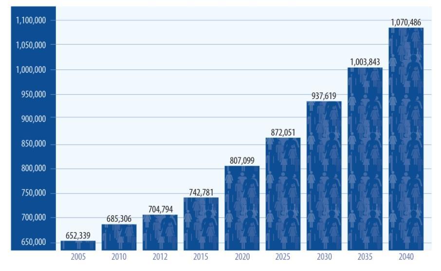
4 San Joaquin County remains one of the fastestgrowing regions in California (Figure 1.4). The County s geographical advantages and quality of life contribute to the growth. San Joaquin County ranks within the top nine of the fastest-growing regions within the state s 58 counties. As compared to the nation s growth rate of 0.9 percent, San Joaquin County s population will grow approximately 1.5 percent annually.


5 -3

6 San Joaquin County encompasses approximately 921,600 acres and is the home of 702,600 residents. In addition to the unincorporated area, the region s incorporated cities are Escalon, Lathrop, Lodi, Manteca, Ripon, Stockton, and Tracy. The county seat is the City of Stockton with a current population of 297,984. Economically, San Joaquin County continues to grow in many segments of its economy. Downtown revitalization efforts in Stockton, Big League Dreams in Manteca, and the Lodi area s success in producing world-class wines are shaping San Joaquin County into a destination for tourism and entertainment. The region also continues to be an attractive location for new warehousing and distribution centers that serve Northern California, the Bay Area, and the West Coast. A centralized and diverse network of highway, rail, air and seaport facilities support the continued development of San Joaquin County into a major goods movement region. There are approximately 207,000 jobs in San Joaquin County. Job creation will continue at a steady pace where San Joaquin County will be supporting nearly 300,000 jobs by the year With over $2 billion in gross value of production in 2011, agriculture continues to be one of the largest-producing industries in San Joaquin County. Additional examples of economic growth include the City of Stockton s downtown revitalization efforts and the emergence of anchor retailer stores such as Bass Pro Shop in Manteca and Costco in Lodi. The new Amazon Fulfillment Center in the City of Tracy is also representative of the future economic potential in San Joaquin County.


7 Due primarily to the availability of housing at lower costs than surrounding communities to the north and to the west of San Joaquin County, the county is a place where many residents travel long distances for employment outside the county. Of the 233,200 residents representing the employed workforce, approximately 114,610 commute outside of the region to their employment sites. The future housing market will continue to grow at a stable rate to accommodate future growth. Currently, the region supports an estimated 219,500 households. Forecasts suggest that by 2040 the housing market will need to grow to accommodate just over 100,000 additional households. As San Joaquin County transforms, these growth factors have profound effects on the ability to finance, deliver, and maintain the transportation infrastructure. Due to its strategic location, maintaining and improving the operational integrity of San Joaquin County s centralized and diverse network of highway, rail, air, and seaport is essential. -5
, a corridor of statewide and national significance.")
8 San Joaquin County s roadway network currently includes 7,114 lane miles. On a north south axis, this includes State Route 99, the Main Street of the San Joaquin Valley, and Interstate 5 (I-5), a corridor of statewide and national significance. Within the last 10 years, each route has experienced dramatic traffic growth and levels of congestion. Each route also carries truck traffic at volumes much higher than the statewide average for the highway system, making them vital to goods movement. State Route 132 handles major east-west movement at the southern tip of the county. Other highway corridors that facilitate goods movement include Interstates 580 (I-580) and 205 (I-205) in the southwest region of the county, as well as State Route 120, State Route 4, and State Route 12. Interstates 205 and 580 serve as the gateway connection between the San Joaquin Valley and the Bay Area, and are critical to interregional travel and commerce. Each, however, has experienced increased travel movement much beyond the statewide average. I-205 in particular remains one of the most impacted travel routes in the county. State Routes 4 and 12 are primarily two-lane conventional highways linking the east and west sides of the county. SR 4 operates as a freeway segment for a brief but important segment between State Route 99 and I-5. Both routes also connect with Bay Area counties across the San Joaquin Delta and carry significant commuter and interregional traffic.

9 Highways 26 and 88 in the central and northeast portion of the county are two-lane rural highways that link to Calaveras and Amador Counties. Each roadway has also experienced significant traffic volume increases, partly due to recreational traffic but also resulting from rapid growth occurring in these neighboring counties to the east. By the year 2040, an additional 594 lane miles will be essential additions to the roadway system, along with non-capacity increasing operational improvement strategies. The Altamont Corridor Express (ACE), formerly the Altamont Commuter Express, is a commuter rail service in California connecting Stockton with San Jose. The service name came from the Altamont Pass, the area through which it travels. The service commenced on October 19, 1998, with two trains daily in each direction (weekdays only). The frequency increased in November 2009 to three trains daily in each direction and then increased to four trains daily in each direction in September There are ten stops along its 86-mile route; present travel time is about 2 hours and 10 minutes from end-to-end. The ACE transit service uses Bombardier Bilevel coaches and MPI F40PH-3C locomotives, which run on tracks owned by Union Pacific Railroad (UPRR). The San Joaquin Regional Rail Commission manages ACE; it is exploring the possibility of expanding service into the central valley between Modesto and Sacramento as well as Stockton and Pittsburg. Bus-related transit services in San Joaquin County have grown dramatically over the past 20 years. The region is currently served by the San JoaquinRegional Transit District, Lodi s Grapeline, the Tracy Tracer, -7

.")
10 Manteca Transit, and smaller transit services in the cities of Escalon (etrans) and Ripon (Blossom Express). The combination of services supports local transit systems, bus rapid transit, intercity and interregional bus transit services, and needed services such as demand response for both those who are in need of transit for medical purposes and those in the rural areas of the county. The movement of goods and people is the primary function of a highly accessible highway and regional roadway transportation system that links San Joaquin County to major destinations (Figure 1.5). The region is a major Northern California transition point where two primary north south highways, I-5 and State Route 99, run through the county. These major highways are joined by the Stockton Crosstown Freeway (State Route 4) and State Route 120 through Manteca. I-5 is the main north-south route for transportation along the west coast from Canada to Mexico. State Route 99 is the main inland route through California connecting the major cities in the San Joaquin Valley. This highway infrastructure positions San Joaquin County as a cost-effective location for large companies interested in operating west coast distribution centers. Interstates 580 and 205 provide direct access to the Bay Area and connections to I-5 and State Route 99.


11 Truck traffic in the county is concentrated along the I-5 and State Route 99 north south corridors. I-5 between Tracy and Lathrop averages 40,000 trucks per day, by far the most truck traffic in the county. North of Lathrop up through Stockton, I-5 averages between 25,000 and 30,000 trucks per day. State Route 99 follows a comparable pattern with traffic at its greatest, around 11,000 average trucks per day, in the region from Stockton south to the Stanislaus County line. The I-205 and I-580 corridors are also principal areas of truck traffic in the county, with average daily truck traffic around 12,000 and 5,000 on these routes, respectively. The region s economic assets include but are not limited to the following: ports of the United States by the US Army Corps of Engineers. In the past decade, the port s commodity tonnage has averaged nearly 2.5 million annually of which more than 95 percent was in overseas trade. The Port of Stockton boasts first class warehouse storage and handling facilities for both dry and liquid bulk materials, facilities and equipment to handle break-bulk, and containerized cargoes by land or sea. The Port of Stockton is situated in the hub of four major freeways, two transcontinental railroads, an international waterway, and a regional airport; it is centrally located to provide the optimum service for shipment and storage of product and cargo. All of these components place the port in an ideal position for domestic and international distribution. The Port of Stockton is 72 nautical miles due east of the Golden Gate Bridge on the Stockton Deepwater Shipping Channel. The port s operations span 2,000 acres, including 11,000 lineal feet of waterside docking with shipside rail, 1.1 million square feet of dockside transit sheds, and 7.7 million square feet of warehousing. It is categorized as one of the principal -9


12 The Stockton Metropolitan Airport supports passenger, private, military, and air cargo operations (Figure 1.6). It is located on the southern boundary of the City of Stockton in the heart of California's Central Valley. Situated on 1,449 acres of land, the Stockton Metropolitan Airport has an 8,650-footlong, 150-foot-wide primary ILS runway, with a takeoff distance available of 11,037 feet. The Stockton Metropolitan Airport also has a 4,458-footlong, 75-foot-wide general aviation runway. Six air carrier gates adjoin the 44,355-square-foot terminal building. Rail is a critical link to the full-service transportation network available in San Joaquin County. The network includes approximately 200 miles of Class I railroads owned by UPRR and Burlington Northern Santa Fe (BNSF). San Joaquin County also features approximately 50 miles of short-line railroads, the Stockton Terminal and Eastern Railroad and the Central California Traction Company (CCT). Additionally, the California Northern Railroad (CFNR) operates the former Southern Pacific West Side line between Tracy and Los Banos in Merced County.

 for the San Joaquin region) to develop regional")
 Support the economic vitality of the")

 Increase the security of the transportation system for motorized and non-motorized users.")
 Protect and enhance the environment, promote energy conservation, improve the quality of")

13 A number of state and federal requirements govern the Plan. A few of the major requirements are summarized below. MAP-21 requires the federally designated metropolitan planning organizations (which is San Joaquin Council of Governments (SJCOG) for the San Joaquin region) to develop regional planning documents that incorporate the metropolitan planning process and consider the following eight federal planning factors: 1) Support the economic vitality of the metropolitan area, especially by enabling global competitiveness, productivity, and efficiency. 2) Increase the safety of the transportation system for motorized and non-motorized users. 3) Increase the security of the transportation system for motorized and non-motorized users. 4) Increase the accessibility and mobility of people and for freight. 5) Protect and enhance the environment, promote energy conservation, improve the quality of life, and promote consistency between transportation improvements and state and local planned growth and economic development patterns. 6) Enhance the integration and connectivity of the transportation system, across and between modes, people and freight. 7) Promote efficient system management and operation. 8) Emphasize the preservation of the existing transportation system. -11
 to protect public health and welfare and to regulate emissions of hazardous air")

14 The act provides regulations for air emissions from stationary and mobile sources. The law authorizes the US Environmental Protection Agency to establish National Ambient Air Quality Standards (NAAQS) to protect public health and welfare and to regulate emissions of hazardous air pollutants. The Plan must forecast transportation emissions and must demonstrate emissions are within the established State Implementation Plan (SIP) budget limits for ozone, PM2.5, PM10, and carbon monoxide. The Plan s compliance with these requirements is documented in the Regional Transportation Plan/Sustainable Communities Strategy Air Quality Conformity Determination. This law set a standard that authoritatively outlawed discrimination in the conduct of all federal activities. It reads as follows: No person in the United States shall, on the ground of race, color, or national origin be excluded from the participation in, be denied the benefits of, or be subjected to discrimination under any program of activity receiving Federal financial assistance. People concerned that everyone within the US deserves equal protection under the country s federal laws created the term environmental justice. President Clinton issued Executive Order in 1994 in response to this concern. The order directs each federal agency to review its procedures and to make environmental justice part of its mission by identifying and addressing the effects of all programs, policies, and activities on minority and low-income populations. The Federal Highway Administration (FHWA) has set policies for integrating environmental justice principles into existing operations to address disproportionate, adverse effects on low-income and minority populations.

15 All federally funded transportation plans, projects, and decisions must involve an environmental justice assessment process that explicitly considers adverse effects or the potential of adverse effects on the environmental justice population. The Plan has an environmental justice analysis that documents the degree to which, to the extent possible, all people, regardless of race, color, national origin, or income, are protected from disproportionate negative or adverse impacts due to the program of projects listed in the Plan. In addition, this analysis also describes whether all neighborhoods have reasonable shares of the benefits from the proposed program. With the passage of Senate Bill (SB) 375 in 2008, metropolitan planning organizations were required to develop a Sustainable Communities Strategy (SCS). An SCS must demonstrate an ambitious, yet achievable, approach to how land use development and transportation can work together to meet greenhouse gas emissions reduction targets for cars and light trucks. These targets set by the California Air Resources Board call for the region to reduce per capita emissions 5 percent by 2020 and 10 percent by If a metropolitan planning organization is unable to meet the targets through the SCS, then an alternative planning strategy demonstrating how targets could be achieved must be developed. As the metropolitan planning organization for San Joaquin County, the SJCOG has developed its first Regional Transportation Plan (RTP) that incorporates an SCS. This document refers to the San Joaquin RTP/SCS simply as the Plan throughout. -13

16 It is important to note that while the RTP builds the SCS as a new element along with the traditional policy element, action element, and financial element, this is not the first plan with sustainability features. San Joaquin s RTP has always embodied policies and strategies committed toward sustainability through air quality measures, environmental preservation and conservation objectives, and growth management strategies. The Plan will guide the San Joaquin region toward a more sustainable future by integrating land use, housing, and transportation planning to build more sustainable communities. Some characteristics of these communities include location in compact development with a focus on infill development, and access to travel options including transit and bike/pedestrian facilities. Sustainability also requires efficiently located communities to better utilize public infrastructure and resources while minimizing impacts to prime farmland. The most significant change resulting from SB 375 is the creation of California Environmental Quality Act (CEQA) streamlining incentives to assist and encourage residential and mixed-use housing projects consistent with the SCS and, in particular, in transit priority areas. CEQA benefits available under SB 375 are for residential and residential mixed-use projects that are consistent with the general use designation, density, building intensity, and applicable policies specified for the project area in the SCS. The Plan must also comply with CEQA, which requires that governmental agencies consider the cumulative regional impact and analyze the environmental consequences of the project. Recognizing the Plan is a program-level EIR which comprises a package of projects within a single program, the SJCOG is responsible as the lead agency to prepare the environmental review of the program of projects. Enacted in November 2009, this act created the Delta Stewardship Council charged with developing, adopting, and implementing the Delta Plan. This plan serves to address strategies of providing reliable water supply for California and protecting, restoring, and enhancing the Delta ecosystems. The Delta Stewardship Council is also responsible for advising local and regional agencies regarding consistency of their planning documents to the
17 Delta Plan. The act requires that covered actions, as defined by the act, and which include plans, programs, or projects within the primary or secondary zones of the Delta, be consistent with the Delta Plan. The SJCOG is required to ensure consistency of the Plan to the adopted Delta Plan. Local project exemptions from Delta Plan requirements are possible if there is a determination that they are consistent with the Plan. This Plan embodies local visions through local input and a highly collaborative approach. Local experts in the fields of housing, land use, environment, and public works participated in the Plan development through a formal advisory committee or through other avenues of public feedback (e.g., workshops, online input through social media or web surveys, public comment opportunities at SJCOG committees and Board meetings). These interests provided perspectives on economic development, environmental preservation, air quality, public health, environmental justice, and farmland conversation/preservation that all helped to reshape existing RTP goals, policies, and objectives. A series of public workshops to get feedback from the public also guided the direction of transportation investments for the region within the context of San Joaquin s future population, employment, and housing growth. All of this feedback helped shape the transportation vision of the future. In addition, emphasis on local land use control surfaced throughout the civic engagement process. The Plan is a transportation investment strategy through 2040, identifying transportation needs to keep pace with anticipated growth and development as well as advancing various sustainability goals. It identifies the funding for these transportation projects in its financial element. While conceptual land use scenarios are essential in building the transportation system and then determining reasonable funding expectations, the Plan does not permit or deny any development projects currently under review or future proposals. The elements of that vision for sustainability helped to refine the following overarching goals that guide the Plan: A. Enhance the Environment for Existing and Future Generations and Conserve Energy B. Maximize Mobility and Accessibility C. Increase Safety and Security D. Preserve the Efficiency of the Existing Transportation System E. Support Economic Vitality F. Promote Interagency Coordination and Public Participation for Transportation Decision-Making and Planning Efforts G. Maximize Cost-Effectiveness H. Improve the Quality of Life for Residents -15

18 The Plan aligns the sustainability goals with transportation investment strategies by focusing on the following building blocks: Identifies land use patterns that encourage infill development and compact development. Makes provisions for new residential development growth that makes shifts from single-family development to more multi-family development. Emphasizes focus on a multimodal strategy of investments that de-emphasizes highway or roadway expansion but still delivers a system to reduce vehicle miles travelled and peak hour traffic congestion. Provides specifically a multimodal transportation network of bus and rail transit, freeway/highway/local roadways, bikeways, walkways, and streetscape projects within available financial resources. Increases transit operational efficiency through investments in bus and rail transit service that includes more frequency of transit service for all income levels as well as expanded transit service. Promotes transit-oriented development and, furthermore, provides for intermodal connections near or within transit-oriented development such as park-and-ride lots and bicycle lanes/paths. Invests in high-tech applications or projects that allow motorists to choose travel options and allow local and state agencies to more quickly respond to incidents on the roadway. Underscores the importance of maintenance through recognition that routine and preventative maintenance is an integral piece toward transportation efficiency. Increases active transportation project investments to facilitate public health and active communities. Encourages new housing and jobs in urbanized areas to better integrate housing, land use, and transportation facilities. Creates and sustains jobs, both directly and indirectly. Invests in infrastructure that improves access to intermodal facilities, airports, the Port of Stockton, and commercial hubs key to goods movement.


19 The Plan demonstrates that the region can meet and exceed the greenhouse gas targets imposed under SB 375. It further shows that those targets can be achieved with land use patterns focused on compact development that more effectively link transportation systems. Just as importantly, the Plan is one of place-making. It harnesses the region s collaborative spirit to create places that enable people to live close to where they work. It encourages healthy and active communities, and at the same time, attracts and maintains businesses that can rely on an optimized transportation system to move and receive goods. Through extensive civic engagement and involvement of local jurisdictions, businesses, environmental, and housing experts, the Plan builds a transportation future where transportation infrastructure can coexist with the goals of habitat conservation, farmland preservation, efficient energy consumption, and economic vitality. -17
CHAPTER 3 THE BUILDING BLOCKS POLICIES AND SUPPORTIVE STRATEGIES REGIONAL TRANSPORTATION PLAN/SUSTAINABLE COMMUNITIES STRATEGY
 CHAPTER 3 THE BUILDING BLOCKS POLICIES AND SUPPORTIVE STRATEGIES REGIONAL TRANSPORTATION PLAN/SUSTAINABLE COMMUNITIES STRATEGY CHAPTER 3 THE BUILDING BLOCKS POLICIES AND SUPPORTIVE STRATEGIES INTRODUCTION
Introduction. CHAPTER 2: Introduction 13
 02 Introduction CHAPTER 2: Introduction 13 14 2018 Draft Regional Transportation Plan/Sustainable Communities Strategy 2 INTRODUCTION The Stanislaus Council of Government s 2018 Regional Transportation
analyst REGIONAL San Joaquin County s Goods Movement System Stockton
 Lodi 12 EBERHARDT SCHOOL OF BUSINESS Business Forecasting Center in partnership with San Joaquin Council of Governments 99 26 5 205 Tracy 4 Lathrop Stockton 120 Manteca Ripon Escalon REGIONAL analyst JULY
Appendix O Congestion Management Program REGIONAL TRANSPORTATION PLAN/SUSTAINABLE COMMUNITIES STRATEGY
 Appendix O Congestion Management Program REGIONAL TRANSPORTATION PLAN/SUSTAINABLE COMMUNITIES STRATEGY 2014 REGIONAL CONGESTION MANAGEMENT PROGRAM 2014 RTP/SCS APPENDIX O SAN JOAQUIN COUNCIL OF GOVERNMENTS
NOTICE OF PREPARATION
 City of Ceres City of Hughson City of Modesto City of Newman City of Oakdale City of Patterson City of Riverbank City of Turlock City of Waterford County of Stanislaus Date: January 4, 2013 NOTICE OF PREPARATION
CHAPTER 7 A FRAMEWORK FOR MOVING FORWARD CHALLENGES AND OPPORTUNITIES REGIONAL TRANSPORTATION PLAN/SUSTAINABLE COMMUNITIES STRATEGY
 CHAPTER 7 A FRAMEWORK FOR MOVING FORWARD CHALLENGES AND OPPORTUNITIES REGIONAL TRANSPORTATION PLAN/SUSTAINABLE COMMUNITIES STRATEGY CHAPTER 7 A FRAMEWORK FOR MOVING FORWARD CHALLENGES AND OPPORTUNITIES
Once known as warehousing and distribution, the process
 Map III-2.3 Proposed Agile Port Industrial Area AGILE PORT INDUSTRIAL AREA PLAN Once known as warehousing and distribution, the process of moving goods to market has evolved dramatically. No longer is
Goods Movement COLLABORATIVE AND PLAN. Arthur L. Dao, Alameda CTC Executive Director ALAMEDA COUNTY TRANSPORTATION COMMISSION. September 17, 2015
 ALAMEDA COUNTY TRANSPORTATION COMMISSION Goods Movement COLLABORATIVE AND PLAN A presentation to the California Marine Affairs and Navigation Conference Arthur L. Dao, Alameda CTC Executive Director 1
Chapter 4: Transportation and Land Use
 Chapter 4: Transportation and Land Use Transportation and land use together make possible the wide range of destination opportunities in the region. Transportation provides the connections, and, in turn,
Tri-County Regional Planning Commission 2045 Regional Metropolitan Transportation Plan Goals and Objectives Adopted March 22, 2017
 Tri-County Regional Planning Commission 2045 Regional Metropolitan Transportation Plan Goals and Objectives Adopted March 22, 2017 One of the initial steps in the development of the TCRPC 2045 Metropolitan
CHAPTER 5: TRANSPORTATION
 CHAPTER 5: TRANSPORTATION GOAL 12: TRANSPORTATION BACKGROUND SUMMARY INTRODUCTION Albany s location and transportation facilities provide excellent advantages for commerce and economic development. Albany
Los Angeles Area Chamber of Commerce, 08/05/14
 Los Angeles Area Chamber of Commerce, 08/05/14 Overview California s global trade position Trade Corridors Improvement Fund (TCIF) Federal and State Encouragement & Requirements California Freight Advisory
Texas Freight Mobility Plan. Chapter 1: Introduction
 Texas Freight Mobility Plan Chapter 1: Introduction Draft August 8, 2014 The Texas Freight Mobility Plan (the Freight Plan) gives Texas a road map for boosting our economic growth potential through a solid
Technical Memorandum 3 Executive Summary Existing Conditions and Constraints Presentation. March 22, 2006
 Technical Memorandum 3 Executive Summary Existing Conditions and Constraints Presentation March 22, 2006 MCGMAP Overview Develop a: Goods Movement Action Plan M A X I M I Z E S Mitigation of communities'
SUPPLEMENTAL NOTICE OF PREPARATION OF AN ENVIRONMENTAL IMPACT REPORT. ACEforward Notice of Additional Project Element Niles Junction Connections
 SUPPLEMENTAL NOTICE OF PREPARATION OF AN ENVIRONMENTAL IMPACT REPORT DATE: May 9, 2016 FROM: TO: SUBJECT: San Joaquin Regional Rail Commission Agencies, Organizations, and Interested Parties ACEforward
CHAPTER 6 TRANSPORTATION PLAN AND POLICIES
 CHAPTER 6 TRANSPORTATION PLAN AND POLICIES TRANSPORTATION PLAN AND POLICIES The extent to which the 2014 RTP/SCS improves the performance of the region s transportation system, improves mobility and access,
SCS Scenario Planning
 E SCS Scenario Planning Introduction As part of the 2035 MTP/SCS process, AMBAG developed a series of land use and transportation alternative scenarios for evaluation and testing to demonstrate how the
Connectivity North and Beyond Nevada s I 80 Corridor
 I 11 NORTHERN NEVADA ALTERNATIVES ANALYSIS Connectivity North and Beyond Nevada s I 80 Corridor May 2018 Prepared for Nevada Department of Transportation Contents 1. Introduction... 1 1.1. I 11 Corridor
SUSTAINABLE COMMUNITIES STRATEGY
 SUSTAINABLE COMMUNITIES STRATEGY Introduction With each RTP update cycle, BCAG prepares a Sustainable Communities Strategy (SCS) as required under Senate Bill 375 (SB 375). The SCS demonstrates the integration
REGIONAL PLANNING AND POLICY FRAMEWORK A Preferred Approach for our Regional Growth
 REGIONAL PLANNING AND POLICY FRAMEWORK A Preferred Approach for our Regional Growth The Regional Comprehensive Plan (RCP) establishes a new approach to planning in the San Diego region. This approach is
2004 FEASIBILITY STUDY UPDATE
 Austin-San Antonio Intermunicipal Commuter Rail District 2004 FEASIBILITY STUDY UPDATE December 2004 EXECUTIVE SUMMARY INTRODUCTION Almost 3 million people in Central Texas, living and working between
Chapter 5. Congestion Management Program. Chapter 5
 Chapter 5 Congestion Management Program Chapter 5 67 Chapter 5 Congestion Management Program Enacted in the early 1990s, California s Congestion Management Program (CMP) statutes encourage local jurisdictions
MOBILITY 2045: A FOCUS ON TRANSPORTATION CHOICE:
 Mobility 2045: The Metropolitan Transportation Plan for North Central Texas is the defining vision for the multimodal transportation system in the Dallas- Fort Worth Metropolitan Planning Area. The plan,
Airports in the Region Case Study
 DESTINATION LINDBERGH: COLLABORATION AND VISION TO MEET SAN DIEGO S MOBILITY NEEDS By Bob Leiter, FAICP, Keith Wilschetz, and Tait Galloway INTRODuCTION Destination Lindbergh was a year-long, comprehensive
CHAPTER HIGHLIGHTS GOALS AND GUIDING POLICIES 60 SEEKING PUBLIC INPUT TO REFINE SCENARIOS FOR OUR FUTURE 61
 04 CHAPTER HIGHLIGHTS GOALS AND GUIDING POLICIES 60 SEEKING PUBLIC INPUT TO REFINE SCENARIOS FOR OUR FUTURE 61 SCENARIOS FOR THE FUTURE: IT S OUR CHOICE 63 CREATING A PLAN FOR OUR FUTURE The RTP/SCS is
GUIDING PRINCIPLES MEMORANDUM
 M E T R O P O L I TAN TRA NS P O RTATI O N PLAN GUIDING PRINCIPLES MEMORANDUM El Paso Metropolitan Planning Organization INTRODUCTION The guiding principles for development of the El Paso MPO s Destino
TEXAS FREIGHT MOBILITY PLAN: DRAFT KEY POLICY RECOMMENDATIONS
 TEXAS FREIGHT MOBILITY PLAN: DRAFT KEY POLICY RECOMMENDATIONS Texas Freight Advisory Committee Midland August 14, 2014 Draft Key Policy Recommendations August 14, 2014 2014 Freight Mobility Plan Recommendations
Database and Travel Demand Model
 Database and Travel Demand Model 7 The CMP legislation requires every CMA, in consultation with the regional transportation planning agency (the Metropolitan Transportation Commission (MTC) in the Bay
Chapter 3 - Goals, Objectives, & Strategies
 Chapter 3 - This chapter presents goals, objectives, and strategies that have been developed as part of the Richmond Area MPO 2026 Long-Range Transportation Plan (LRTP) update. Strategies have been developed
Chapter 1 Introduction
 Chapter 1 Introduction KEY POINTS The amount and value of freight are critical components of the overall economic health of Missouri. Missouri s multimodal freight system supports the movement of trucks,
NEW YORK TRANSPORTATION FACTS ECONOMIC IMPACTS
 The 2015 U.S. Transportation Construction Industry Profile: New York page 1 NEW YORK TRANSPORTATION FACTS ECONOMIC IMPACTS The design, construction and maintenance of transportation infrastructure in New
2. Goals and Objectives
 Pedestrians in Charlotte s busy Uptown. CRTPO Mission The mission of the Charlotte Regional Transportation Planning Organization (CRTPO) is to plan for transportation options that ensure mobility, respect
Growth in the Fresno Metro Area
 1 Growth in the Fresno Metro Area 2 A Unique Opportunity Meeting City and Regional Challenges SEGA 9,000 Acres 3 A Unique Planning Process Measuring Up to the Challenge Modeling the Impacts of Different
Memorandum. FROM: Jim Ortbal Rosalynn Hughey Barry Ng TO: HONORABLE MAYOR, CITY COUNCIL. DATE: June 16, 2017
 CITY OF SANjOSE CAPITAL OF SILICON VALLEY TO: HONORABLE MAYOR, CITY COUNCIL SUBJECT: TRANSPORTATION POLICY UPDATE REQUIRED BY STATE LAW - LOS TO VMT Memorandum FROM: Jim Ortbal Rosalynn Hughey Barry Ng
CHAPTER 4 HIGHLIGHTS GOALS AND GUIDING POLICIES 64 SEEKING PUBLIC INPUT TO REFINE SCENARIOS FOR OUR FUTURE 66
 04 CHAPTER 4 HIGHLIGHTS GOALS AND GUIDING POLICIES 64 SEEKING PUBLIC INPUT TO REFINE SCENARIOS FOR OUR FUTURE 66 SCENARIOS FOR THE FUTURE: IT S OUR CHOICE 68 CREATING A PLAN FOR OUR FUTURE The RTP/SCS
METROPOLITAN BAKERSFIELD GENERAL PLAN UPDATE GREATER BAKERSFIELD CHAMBER OF COMMERCE
 METROPOLITAN BAKERSFIELD GENERAL PLAN UPDATE GREATER BAKERSFIELD CHAMBER OF COMMERCE JUNE 12, 2009 PURPOSE OF WORKSHOP MAJOR INFLUENCES PUBLIC OUTREACH REPORT EXISTING CONDITIONS REPORT SB 375/AB 32/AB
12 Evaluation of Alternatives
 12 Evaluation of Alternatives This chapter evaluates the effectiveness of the No-Build Alternative and the proposed METRO Blue Line Light Rail Transit (BLRT) Extension project based on the information
The Policies section will also provide guidance and short range policies in order to accomplish the goals and objectives.
 4 Goals & Objectives INTRODUCTION The 2015-2040 MTP preserves and promotes the quality of life and economic prosperity of the MAB by providing a transportation system consistent with the regional goals.
MAP 21 Freight Provisions and Seaports
 MAP 21 Freight Provisions and Seaports September 20, 2012 American Association of Port Authorities 703.684.5700 www.aapa-ports.org 3 New Freight Eligibility in Core Highway Formula Programs Surface Transportation
Central Valley Rail Working Group 1. INTRODUCTIONS
 CVRWG Meeting: February 24, 2017 Central Valley Rail Working Group 1. INTRODUCTIONS Central Valley Rail Working Group 2. SJJPA Update Dan Leavitt, SJJPA CVRWG Meeting: February 24, 2017 Morning Express
GULF COAST RAIL DISTRICT VISION FOR REGIONAL RAIL
 GULF COAST RAIL DISTRICT VISION FOR REGIONAL RAIL OCTOBER 2014 Cover photographs courtesy of Top left - Mike Bates TABLE OF CONTENTS MISSION... 1 INTRODUCTION... 1 VISION STATEMENT... 1 BACKGROUND... 2
SECTION 5. Existing Conditions TRANSPORTATION NETWORK TRANSPORTATION
 SECTION 5 TRANSPORTATION Transportation systems are vital for moving people and goods and serving existing businesses. They also play a major role in guiding the location and type of development. The following
ALBION FLATS DEVELOPMENT EXISTING TRAFFIC CONDITIONS AND POTENTIAL IMPACTS
 EXISTING TRAFFIC CONDITIONS AND POTENTIAL IMPACTS FINAL REPORT SEPTEMBER 2010 TABLE OF CONTENTS 1.0 INTRODUCTION 1 2.0 EXISTING TRAFFIC CONDITIONS 2 3.0 FUTURE TRAFFIC CONDITIONS 3 4.0 POTENTIAL IMPACTS
AGENDA ITEM PLANNING COMMISSION MEETING DATE APRIL 13, 2017 BUSINESS ITEMS. FROM : Community Development Department Director
 AGENDA ITEM PLANNING COMMISSION MEETING DATE APRIL 13, 2017 BUSINESS ITEMS DATE : April 3, 2017 TO : Planning Commission FROM : Community Development Department Director SUBJECT : BENICIA INDUSTRIAL PARK
Chapter 6 Freight Plan
 Chapter 6 Freight Plan Overview This chapter presents a review and assessment of needs, deficiencies, policies and improvement options affecting the freight transportation system within the Medford Urban
Executive Summary. TCAG 2014 Regional Transportation Plan
 Executive Summary TCAG 2014 Regional Transportation Plan About Tulare County Tulare County is located in California's San Joaquin Valley (SJV)[Figure 1-1]. Tulare County is bordered by Inyo County to the
HEARTLAND HUB WITH GLOBAL REACH
 HEARTLAND HUB WITH GLOBAL REACH Patrick Robinson Vice President NorthPoint Development 816.888.7872 patrick@northpointkc.com Eric N. Goodman Regional Manager Economic Development BNSF Railway 913.551.4550
Progress Report on the Implementation of the Strategic Intermodal System (SIS)
") Progress Report on the Implementation of the Strategic Intermodal System (SIS) Supplement to the Review of the Department of Transportation Tentative Work Program FY 2007/08 through 2011/12 March 20, 2007
Progress Report on the Implementation of the Strategic Intermodal System (SIS) Supplement to the Review of the Department of Transportation Tentative Work Program FY 2007/08 through 2011/12 March 20, 2007
VISION STATEMENT, MISSION STATEMENT, AND GOALS AND OBJECTIVES
 VISION STATEMENT, MISSION STATEMENT, AND GOALS AND OBJECTIVES Vision Statement: Our vision is to provide a high quality, safe, efficient, and cost-effective multi-modal transportation system that supports
Stockton Freight & Passenger Rail Mobility Enhancement
 Stockton Freight & Passenger Rail Mobility Enhancement 2017 $10.34 million in 2017 FASTLANE Grant funding to complete engineering design, permitting, and construction of the Stockton Track Extension and
Honorable Mayor and Members of the City Council. Submitted by: Dan Marks, Director, Planning and Development
 Office of the City Manager To: From: Honorable Mayor and Members of the City Council Phil Kamlarz, City Manager Submitted by: Dan Marks, Director, Planning and Development Subject: EXECUTIVE SUMMARY Senate
Greater Golden Horseshoe Transportation Plan
 Greater Golden Horseshoe Transportation Plan Transportation Profile Executive Summary October 2017 PREPARED BY Urban Strategies Inc. and HDR for the Ministry of Transportation TRANSPORTATION PROFILE -
TRANSPORTATION RELATIONSHIP TO OTHER ELEMENTS OF THE PLAN AND COUNTY REGULATIONS VISION FOR TRANSPORTATION PLANNING ROAD NETWORK SECTION 7
 TRANSPORTATION Like many growing western counties, Douglas County focuses on one of the most integral elements in land-use planning: transportation. The primary purpose of a transportation network is to
Chapter 9: Vision Plan. Chapter 9. Vision Plan. Lake Loveland. Image 179 Credit: City of Loveland
 Chapter 9 Vision Plan Lake Loveland. Image 179 Credit: City of Loveland Chapter 9: Vision Plan A. Regionally Significant Corridor and Regional Bike Corridor Visions Corridor visioning seeks to develop
TEXAS FREIGHT MOBILITY PLAN 2017
 TEXAS FREIGHT MOBILITY PLAN 2017 Texas Transportation Commission September 28, 2017 Overview of the Texas Freight Mobility Plan 2016 Plan First multimodal freight mobility plan Identified freight network,
1.0 Introduction to Transportation Planning
 1.0 Introduction to Transportation Planning A good plan is like a road map: it shows the final destination and usually the best way to get there. H. Stanley Judd 1.1 Purpose Why is Transportation Planning
PROJECTS. The KIPDA MPO s Central Location
 PROJECTS Freight The economy of the Louisville KY-IN) Metropolitan Planning Area MPA), similar to that of the United States as a whole, is largely dependent on the efficient, reliable, and safe movement
Mobility and System Reliability Goal
 Mobility and System Reliability Goal Provide surface transportation infrastructure and services that will advance the efficient and reliable movement of people and goods throughout the state. Background:
SIS Policy & Implementation
 SIS Policy & Implementation Performance Planning & Programming (before it was cool) presented by Carl Mikyska, Florida MPO Advisory Council October 25, 2017 Strategic Intermodal System (SIS) Background
Safety and Security for Residents, Visitors, and Businesses
 Safety and Security for Residents, Visitors, and Businesses SAFETY Design roadways mindful of the most vulnerable users Reduce user-related crashes of all modes Promote collaboration, safety awareness,
FACT SHEETS LOS ANGELES COUNTY
 FACT SHEETS LOS ANGELES COUNTY WHAT IS THE REGIONAL TRANSPORTATION PLAN/ SUSTAINABLE COMMUNITIES STRATEGY (RTP/SCS) Every four years the Southern California Association of Governments (SCAG) prepares a
Centered on global trade.
 Centered on global trade. A world of customers and suppliers is as close as the Port of Little Rock. The Little Rock Port Authority (LRPA) was organized in 1959 to oversee the Port and provide intermodal
Chapter 5 Transportation Draft
 Chapter 5 Transportation Draft Discussion Similar to the other elements in the Comprehensive Plan, the transportation element impacts the quality of life, economic development and public safety of the
4: Transportation and Land Use
 Chapter Figure 4-1: Recent development has brought more housing and mixed use Downtown Minneapolis - looking north from E 15th Street at the Grant Street / 11th Street exit 4: Transportation and Land Use
MnDOT Overview. Charlie Zelle Commissioner, MnDOT Jan. 23, 2017
 MnDOT Overview Charlie Zelle Commissioner, MnDOT Jan. 23, 2017 Creation of MnDOT Minnesota Statutes, Sections 174.01-174.03 Created by the Legislature in 1976 Combined former Department of Aeronautics,
Regional Goods Movement Planning in the Bay Area
 M E T R O P O L I T A N T R A N S P O R T A T I O N C O M M I S S I O N Regional Goods Movement Planning in the Bay Area Matt Maloney, Principal September 17, 2015 Metropolitan Transportation Commission
Transportation Advisory Board May 21, 2014
 Transportation Advisory Board May 21, 2014 1 2040 TPP Schedule April 2013 to May 2014: Policymaker Task Force, Partner Agency Work Group and other stakeholder discussions on preparation of draft 2040 TPP
Contents i Contents Page 1 A New Transportation Plan Community Involvement Goals and Objectives... 11
 Contents i Contents 1 A New Transportation Plan... 1 Why develop a new plan?... 1 What area does the LRTP focus on?... 2 Why is this LRTP important?... 3 Meeting Requirements for Transportation Planning...
Proposed Council Changes to Comprehensive Plan
 Chapter 6 Transportation Page and line numbers reflect Planning Commission Recommended Draft dated 1/14/16 (http://wawhatcomcounty.civicplus.com/documentcenter/view/15155 ). To improve clarity of Councilmember
TRANSPORTATION AND LAND USE
 TRANSPORTATION AND LAND USE INTRODUCTION The 2020 and 2030 GHG projections estimate that transportation emissions in the unincorporated area will increase considerably in the next two decades. Minimizing
Environmental Impact Statement for the Green Line to the Airport Project. ACTION: Notice of Intent to Prepare an Environmental Impact Statement (EIS).
.") This document is scheduled to be published in the Federal Register on 11/18/2015 and available online at http://federalregister.gov/a/2015-29418, and on FDsys.gov DEPARTMENT OF TRANSPORTATION Federal Transit
This document is scheduled to be published in the Federal Register on 11/18/2015 and available online at http://federalregister.gov/a/2015-29418, and on FDsys.gov DEPARTMENT OF TRANSPORTATION Federal Transit
FACT SHEETS SAN BERNARDINO COUNTY
 FACT SHEETS SAN BERNARDINO COUNTY WHAT IS THE REGIONAL TRANSPORTATION PLAN/ SUSTAINABLE COMMUNITIES STRATEGY (RTP/SCS) Every four years the Southern California Association of Governments (SCAG) prepares
Appendix S. Monitoring Performance. Monitoring Performance. Appendix Contents
 Appendix S Monitoring Performance Appendix Contents Monitoring Performance Monitoring Performance San Diego Forward: The Regional Plan builds upon and combines elements from the SANDAG 2050 Regional Transportation
Freight and Rail Stakeholder Webinar. January 7, 2014
 Freight and Rail Stakeholder Webinar January 7, 2014 Agenda Modal Needs Baseline Revenue Modal Scenarios Website Statewide Freight Plan Statewide Rail Plan Jeff Carroll MULTIMODAL TRANSPORTATION NEEDS
AASHTO Policy Papers Topic IX: Freight
 1 AASHTO Policy Papers Topic IX: Freight Approved 4/22/02 IX-1. The U.S. DOT and AASHTO should jointly sponsor development of a freight planning capacity building process. Up to $10 million annually should
Section 7 Environmental Constraints
 Section 7 Environmental Constraints i Yakima Valley Metropolitan and Regional Transportation Plan Public Comment DRAFT 1/27/2016 Environmental Constraints Analysis A programmatic-level review of potential
5 CEQA Required Conclusions
 5 CEQA Required Conclusions This section presents a summary of the impacts of the proposed Pacifica General Plan on several subject areas specifically required by CEQA, including significant irreversible
- FACT SHEET - THE GUIDING PRINCIPLES
 THE GUIDING PRINCIPLES The General Plan begins with seven ideas that together create a vision for the City s future. When the City approved the General Plan in 1994, these idea were dubbed the Seven Guiding
Towards a Greener Southern California: Regional Transportation Plan/ Sustainable Communities Strategy
 SOUTHERN CALIFORNIA ASSOCIATION of GOVERNMENTS Towards a Greener Southern California: 2012-2035 Regional Transportation Plan/ Sustainable Communities Strategy Hasan Ikhrata Executive Director 2 SCAG Quick
Mobility 2025 Update: The Metropolitan Transportation Plan
 Mobility 2025 Update: The Metropolitan Transportation Plan May, 2001 North Central Texas Council of Governments Transportation Department MOBILITY 2025 UPDATE FINANCIAL SUMMARY Metropolitan Transportation
Purpose and Organization PROGRAM ENVIRONMENTAL IMPACT REPORT. Native American Consultation Workshop
 PROGRAM ENVIRONMENTAL IMPACT REPORT Native American Consultation Workshop A Presentation by the Southern California Association of Governments October, 2015 Purpose and Organization Introduction Draft
I-580 Interregional Multi-Modal Corridor Study
 Final Report for: I-580 Interregional Multi-Modal Corridor Study IMAGE FROM GOOGLE EARTH PRO Submitted by: Dowling Associates, Inc. Transportation Engineering Planning Research Education 428 J Street,
TEXAS FREIGHT MOBILITY PLAN. Greater Houston Freight Committee Kick-Off Meeting
 TEXAS FREIGHT MOBILITY PLAN Greater Houston Freight Committee Kick-Off Meeting July 11, 2016 Overview of Texas Freight Mobility Plan The Freight Plan is TxDOT's first multimodal transportation plan that
MEMORANDUM #4. DATE: November 4, Warrenton TSP Project Management Team. Ray Delahanty, AICP, DKS Associates Kate Petak, EIT, DKS Associates
 MEMORANDUM #4 DATE: November 4, 2015 TO: FROM: SUBJECT: Warrenton TSP Project Management Team Ray Delahanty, AICP, DKS Associates Kate Petak, EIT, DKS Associates Warrenton Transportation System Plan Update
SAN DIEGO FORWARD THE REGIONAL PLAN OUR REGION AT A CROSSROADS. A PLAN TO GUIDE OUR WAY. VISION. Healthy Environment & Communities
 JUNE 2015 SAN DIEGO FORWARD THE REGIONAL PLAN OUR REGION AT A CROSSROADS. A PLAN TO GUIDE OUR WAY. We live in one of the most beautiful regions in the country. As we grow in the coming decades, we can
METROPOLITAN PLANNING ORGANIZATION FOR THE MIAMI URBANIZED AREA BLOCKS RIBBONS EXERCISE
 BLOCKS RIBBONS EXERCISE Welcome and thank you for making the decision to take part in the Miami-Dade Long Range Transportation Plan (LRTP) planning process. Based on forecasts from the Miami-Dade County
Future of Transportation in Florida
 Future of Transportation in Florida Florida Transportation Commission Meeting of the Modes February 12, 2007 Bob Romig, Director Office of Policy Planning Florida Department of Transportation Key Trends
CHAPTER 1. A New Transportation Plan
 Chapter 1. A New Transportation Plan 1 CHAPTER 1. A New Transportation Plan Why develop a new plan? The year 2005 marks 90 years since Anchorage emerged as a community serving as headquarters for railroad
Summary of transportation-related goals and objectives from existing regional plans
 SMTC 2050 Long Range Transportation Plan Appendix A: Summary of transportation-related goals and objectives from existing regional plans SMTC 2050 Long Range Transportation Plan Summary of transportation-related
2040 Transportation Policy Plan Conversion to Performance Based Planning Basis. 25 th Annual CTS Transportation Research Conference May 21, 2014
 2040 Transportation Policy Plan Conversion to Performance Based Planning Basis 25 th Annual CTS Transportation Research Conference May 21, 2014 1 About the plan Long-range transportation plan for the Twin
WTP Phase 2 Implementation & Freight System Plan
 WTP Phase 2 Implementation & Freight System Plan Tribal Transportation Planning Organization Kathy Murray Planning Studies Group; Multimodal Planning Division Jason Beloso, Strategic Planning Manager;
2. Guiding Principles, Objectives, and Policies
 2. Guiding Principles, Objectives, and Policies INTRODUCTION The guiding principles for the 2040 MTP Update establish the vision and key focus areas for this planning effort. They combine the guidance
POLK COUNTY TPO Polk County 2060 Transportation Vision Plan Final Report. ADOPTED June 18, 2009
 POLK COUNTY TPO Polk County 2060 Transportation Vision Plan Final Report ADOPTED June 18, 2009 TABLE OF CONTENTS CHAPTER 1 Introduction and Prior Planning Effort...Page 1-1 CHAPTER 2 Population and Employment
Economic Development Planning, Summary 30
 Economic Development Planning, Summary 30 Unless otherwise noted, summaries represent findings and analyses by the listed source, not by Morrison Institute for Public Policy or Arizona State University.
CHAPTER 2.0: INTRODUCTION
 CHAPTER 2.0: INTRODUCTION 2.1 INTRODUCTION The Federal Transit Administration (FTA) and the Santa Clara Valley Transportation Authority (VTA) have prepared this Environmental Impact Statement/Environmental
Chapter 5 - Transportation
 Chapter 5 - Transportation Discussion Similar to the other elements in the Comprehensive Plan, the transportation element impacts the quality of life, economic development and public safety of the residents
2017 Freight System Plan
 2017 Freight System Plan Washington State Freight Advisory Committee (WAFAC) Meeting April 21, 2017 MP 1 Introductions WAFAC members are participating: at WSDOT headquarters (Olympia) over the phone MP
6.11 Integrated Land Use, Air Quality & Transportation Planning
 6.11 Integrated Land Use, Air Quality & Transportation Planning This chapter identifies the need for an interdisciplinary approach to integrate land use, transportation, and air quality planning efforts
America s Central Port is the St. Louis region s only full-service, public intermodal port. The 1,200-acre mixed-use business campus offers
 America s Central Port is the St. Louis region s only full-service, public intermodal port. The 1,200-acre mixed-use business campus offers development-ready industrial sites, over 1.7 million square feet