The influence of large scale inhomogeneities on a construction dewatering system in chalk Dr Toby Roberts. CTRL Thames Tunnel
|
|
|
- Agnes Bridges
- 6 years ago
- Views:
Transcription

1 The influence of large scale inhomogeneities on a construction dewatering system in chalk Dr Toby Roberts CTRL Thames Tunnel
2 CTRL 320 Thames Tunnel ( 133M) Twin 2.5 km 7.15 m diameter bored tunnel beneath River Thames. Dewatering required for approach structures, 400 m by 28 m in plan by up to 18 m below groundwater level. Project Management: RLE (Arup Bechtel Halcrow SYSTRA) Main Contractor: HOCHTIEF MURPHY JV Dewatering: WJ GROUNDWATER LTD

3 CTRL Thames Tunnel dewatering for approach structures Tank farm Northern approach Tunnels Southern approach

4 Southern approach Longitudinal Tunnel Section
5 CTRL Thames Tunnel Cross-section of approach Roof slab Discharge main Standing W.L Diaphragm wall Internal wall Target drawdown Wells
6 mod S1 S2 S3 S4 75m 135m 115m 120m m OD 0 Alluvium 0-10 Terrace Gravels Upper Chalk Tunnel portal D-wall Toe Formation Cross cut-off Dewatering of a 445 m x 28 m structure with side support by diaphragm walls, divided into 4 sections (S1 to S4) Formation level from 18 to 6 mbgl Southern Approach Geological Section
7 Thames Thames N The extent of the Chalk outcrop Tunnel portal CONFINED AQUIFER Approach structure UNCONFINED AQUIFER Pump test location m
8 Depth (mod) m/d South side pump test North side data Test in piezometers Packer tests E E E E E E-02 Permeability (m/s) Chalk permeability depth profile

9 From CIRIA C515 Chalk Gravel Range of application of dewatering techniques
10 Design Information: Pumping Test: Terrace Gravels k = m/s 260 m/d Pumping Test: Chalk: k h = m/s 17 m/d Packer Tests (North Side) Chalk k decreases with depth Conventional wisdom suggests former spring line and elevated k zone along line of Chalk outcrop (cut-off?) Design Basis: Terrace Gravels k h = k v = m/s 260 m/d Chalk k h = k v = m/s 17 m/d

11 River River 3D Numerical model: Used as design basis Used to consider interaction between sections Used for sensitivity analysis Used to look at hydrostatic load on D- wall MODFLOW finite difference grid
12 Dewatering Scheme Design Section S1 S2 S3 S4 Length (m) Dig depth (mod) Design flow (l/s) /120 72/120 No. of wells (12 to 20 l/s) Total design flow: 600 l/s Total No. of wells: 42 No.
13 DESIGN FLOW S1 192 l/s S2 168 l/s S3 72 to 120 l/s S4 72 to 120 l/s N LEGEND: Designed dewatering well Piezometer 0 50m

14 Level (m OD) CL +2 0 MG AL -10 TG -20 CHK -30 Internal deepwell dewatering system

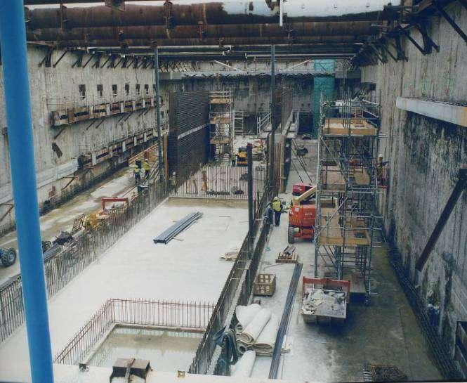
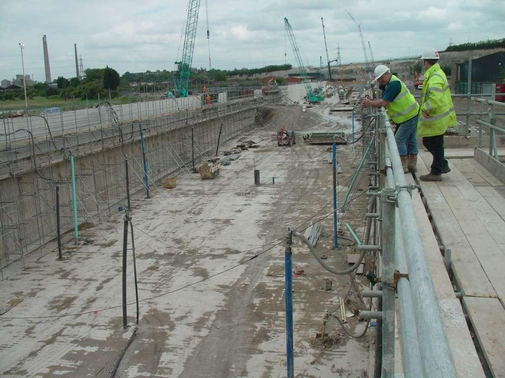
15 Aerial view of southern approach structure (Excavation in S1 and S2 underway)
16 Dewatering Wells
17


18 Water outfalls into the Thames via discharge main
19 Discharge flow (l/s) S1 S1, 2 S1, 2, 3 S1, 2, 3, Nov 01 Feb 02 May 02 Aug 02 Nov 02 Feb 03 May 03 Aug 03 Flow Record
20 Comparison between design capacity and actual flows Section S1 S2 S3 S4 Length (m) Depth (mod) Design flow (l/s) /120 72/120 Actual Flow (l/s)
21 ACTUAL FLOW S1 12 l/s S2 206 l/s S3 131 l/s S4 290 l/s N LEGEND: Designed dewatering well Piezometer Additional dewatering well 0 50m
22 S1 S2 S3 S4 SPECIFIC CAPACITY (m 2 /day) < to 400 Zone of highly 0 50m 25 to to 800 permeable chalk? 50 to 100 > to 200 NOTE: Specific capacity = flow/drawdown Variation in well performance along approach structure
23 HPZ
24 Thames Thames N Array of remote standpipe piezometers - Tidal fluctuations established prior to start of pumping by datalogging over 24 hr period. - Manual dipping at weekly to monthly intervals for duration of dewatering Chalk piezometer Gravel piezometer Chalk and Gravel piezometers m
25 Depth (m OD) Depth (m OD) Outcrop Chalk High k Chalk 0 SCR TCR 0 SCR TCR Percentage Variation in the quality of cores from the Chalk Percentage
26 Thames 2500 m A Thames Confined Chalk Transition Zone HPZ Chalk Outcrop HPZ A 2500 m Extrapolated size and location of highly permeable zone of Chalk
27 Depth (m OD) Excavation (445 m) Alluvium Terrace Gravels Weathered Chalk Transition Zone HPZ Chalk Outcrop Base Chalk -65 A 2500 m Model section along structure A
28 Design Basis: Terrace Gravels k h = k v = m/s 260 m/d Chalk k h = k v = m/s 17 m/d Best Fit Model: Terrace Gravels: Chalk Outcrop: k h = k v = m/s k h = m/s, k v = m/s High k Chalk: k h = k v = m/s 5,200 m/d Transition Zone: k h = k v = m/s 40 m/d Weathered Chalk: k h = m/s, k v = m/s 0.09 m/d Base Chalk: k h = m/s, k v = m/s
29 mod 0-10 S1 S2 S3 S4 75m 135m 115m 120m m OD Low k v Transition HPZ Southern Approach Geological Section
30 Observations Site investigation did not identify high k zone High k zone expected but scale uncertain cut-off? Anisotropic conditions hard to identify in SI Coped with 2 orders of magnitude change in k Cost/programme impacts modest in this case Flow and drawdown data important in early identification of issues and solution Relatively simple model but no unique solution (piezo residuals +/-0.4 m average, max 0.9 m)
Assessment of Impacts from Groundwater Control Projects
 Assessment of Impacts from Groundwater Control Projects Martin Preene Technical Development Director, Golder Associates Synopsis What is groundwater control? Potential impacts Case studies The future Conclusion
Pumping tests for construction dewatering in chalk
 Lawrence, Preene, Lawrence and Buckley ISBN 978-0-7277-6407-2 https://doi.org/10.1680/eiccf.64072.631 ICE Publishing: All rights reserved Pumping s for construction dewatering in chalk M Preene *1, T O
EXTRACT. MONITOR. CONTROL.
 GUIDANCE OF ABSTRACTION AND DISCHARGE PERMITS FOR OPERATIONS When considering any potential dewatering requirement, it is necessary to consider the following questions: Are we allowed to abstract groundwater,
Abstract. Introduction
 Invited Paper The modelling of saline intrusion during the construction of submerged tunnels T. Roberts', J. White, Z. Mohammed' "WJ Engineering Resources Ltd. Civil Engineering, Queen Mary and Westfield
SOURCES OF WATER SUPPLY GROUND WATER HYDRAULICS
 SOURCES OF WATER SUPPLY GROUND WATER HYDRAULICS, Zerihun Alemayehu GROUNDWATER Groundwater takes 0.6% of the total water in the hydrosphere 0.31% of the total water in the hydrosphere has depth less than
Learning Legacy Document Duration of data recorded (approx.) 1
 1") Table 1: Crossrail Water Consumption Data Contract C300/C410 - Crossrail Running Tunnels - West; Bond Street & Tottenham Court Road s - Early Access Shafts & SCL Works (JV: BAM Nuttall Ltd / Ferrovial
Table 1: Crossrail Water Consumption Data Contract C300/C410 - Crossrail Running Tunnels - West; Bond Street & Tottenham Court Road s - Early Access Shafts & SCL Works (JV: BAM Nuttall Ltd / Ferrovial
London s sewerage system was designed by Sir Joseph Bazalgette in the 1850s, for a population of four million
 Thames Tideway Tunnel technical challenges of the Tideway East section Chambers Wharf to Abbey Mills Pumping Station London s sewerage system was designed by Sir Joseph Bazalgette in the 1850s, for a population
London Tideway Tunnels Modernising London s Sewerage System Rob Furniss
 London Tideway Tunnels Modernising London s Sewerage System Rob Furniss AECOM Water Global Director of Community Infrastructure The Background to London s Sewers 1848 Cholera deaths peak In London 1858
4. Groundwater Resources
 4. Groundwater Resources 4-1 Majority (97 %) of unfrozen fresh water on earth exists as groundwater. In comparison to surface water, - groundwater is available all year around - groundwater is mostly invisible
Remediation of the Former Gasworks, High Wycombe, UK
 Remediation of the Former Gasworks, High Wycombe, UK Apr-4-06 MGP Symposium, Reading UK, April 2006 Presented By Stuart Arch Apr-4-06 4/4/06 WPREpresentation1.ppt 1 Site Setting Contents of Presentation
Multiphase Extraction (MPE):
:") Multiphase Extraction (MPE): Remediation Trials in New Zealand 2010 Richard Howard Senior Environmental Scientist URS New Zealand Ltd CHRISTCHURCH 2 Contents Background to Multiphase Extraction (MPE) Introduce
Multiphase Extraction (MPE): Remediation Trials in New Zealand 2010 Richard Howard Senior Environmental Scientist URS New Zealand Ltd CHRISTCHURCH 2 Contents Background to Multiphase Extraction (MPE) Introduce
Edithvale and Bonbeach Level Crossing Removal Project
 Edithvale and Bonbeach Level Crossing Removal Project Passive subsurface horizontal drain Peer Review Kim Chan Work undertaken and general comments Scope of my review in relation to the Edithvale project:
Assessment of the Groundwater Quantity Resulting from Artificial Recharge by Ponds at Ban Nong Na, Phitsanulok Province, Thailand
 Research article erd Assessment of the Groundwater Quantity Resulting from Artificial Recharge by Ponds at Ban Nong Na, Phitsanulok Province, Thailand SIRIRAT UPPASIT* Faculty of Technology, Khon Kaen
COPYRIGHTED MATERIAL. Contents PART ONE: THEORY...1. Preface to the Third Edition xiii. About the Authors xv. Acknowledgements xvii
 Preface to the Third Edition xiii About the Authors xv Acknowledgements xvii Contents PART ONE: THEORY...1 1. Groundwater in Construction...3 1.1 Groundwater in the Hydrologic Cycle 3 1.2 Origins of Dewatering
Tools and methods to manage groundwater and settlement effects from the construction of an expressway on peat deposits
 Avanidou T. & Alexander G.J. (2017) Tools and methods to manage groundwater and settlement effects from the construction of an expressway on peat deposits Proc. 20 th NZGS Geotechnical Symposium. Eds.
OUTLINE OF PRESENTATION
 GROUNDWATER?? OUTLINE OF PRESENTATION What is groundwater? Geologic investigation Definitions: aquifer and aquitard, unconfined and semi-confined Water level and interpretation of water level data Well
Cullohill GWS (Toberboe Spring)
") Water Framework Directive Groundwater Monitoring Programme Site Information Cullohill GWS (Toberboe Spring) ImagePath1: Cullohill GWS (Toberboe Spring)\IE_SE_G_059_11_004_A _(800_x_600).jpg Cullohill GWS
Water Framework Directive Groundwater Monitoring Programme Site Information Cullohill GWS (Toberboe Spring) ImagePath1: Cullohill GWS (Toberboe Spring)\IE_SE_G_059_11_004_A _(800_x_600).jpg Cullohill GWS
Simulation of horizontal well performance using Visual MODFLOW
 Environ Earth Sci (2013) 68:1119 1126 DOI 10.1007/s12665-012-1813-x ORIGINAL ARTICLE Simulation of horizontal well performance using Visual MODFLOW Wan Mohd Zamri W. Ismail Ismail Yusoff Bahaa-eldin E.
Pilot Testing of Groundwater Circulation Well Technology for a Caustic Groundwater Plume in a Coastal Aquifer
 Pilot Testing of Groundwater Circulation Well Technology for a Caustic Groundwater Plume in a Coastal Aquifer presented by Lynda Smithard, P.Eng. URS Corporation, Vancouver, BC Background a portion of
Borehole Yield and Quality Testing at Croydon Vineyard Estate, Somerset West. Western Cape.
 Borehole Yield and Quality Testing at Croydon Vineyard Estate, Somerset West. Western Cape. REPORT: GEOSS Report No: 2017/12-13 PREPARED FOR: Tobie Esterhuyzen Estate Manager Croydon Vineyard Estate c/o
Case Study HST Shaft: Llanberis WwTW
 Abstract An 9no. deep well dewatering system for a 12.5m Ø shaft at lanberis WwTW in Gwynedd. The shaft formed part of a new Humus Sedimentation Tank within the existing works and was constructed to 5.9m
Water Framework Directive. Groundwater Monitoring Programme. Site Information. Athlacca
 Water Framework Directive Groundwater Monitoring Programme Site Information Athlacca ImagePath1: Athlacca\Athlacca 1_(800_x_600).jpg Athlacca PWS is situated in a Regional Fissured (Rf) Aquifer. The source
Potential effects evaluation of dewatering an underground mine on surface water and groundwater located in a rural area
 Potential effects evaluation of dewatering an underground mine on surface water and groundwater located in a rural area ITRODUCTIO Michel Mailloux* Eng. M.Sc, Vincent Boisvert, M.Sc, Denis Millette, Eng.,
Charleville WS (BH 3)
") Water Framework Directive Groundwater Monitoring Programme Site Information Charleville WS (BH 3) ImagePath1: Charleville WS (BH 3)\04-008 (a) p.hse_(800_x_600).jpg Charleville WS (BH-3) is a borehole
Water Framework Directive Groundwater Monitoring Programme Site Information Charleville WS (BH 3) ImagePath1: Charleville WS (BH 3)\04-008 (a) p.hse_(800_x_600).jpg Charleville WS (BH-3) is a borehole
Dynamic groundwater-river interaction model for planning water allocation in a narrow valley aquifer system of the Upper Motueka catchment
 Dynamic groundwater-river interaction model for planning water allocation in a narrow valley aquifer system of the Upper Motueka catchment Timothy Hong t.hong@gns.cri.nz Gilles Minni g.minni@gns.cri.nz
4.4 MODEL CODE DESCRIPTION 4.5 WATER SOURCES AND SINKS 4.6 MODEL DOMAIN AND BOUNDARIES. SLR South Africa
 Page 4-18 The developed model should therefore be seen as an initial site model which should be refined and recalibrated once more groundwater monitoring and other data become available. 4.4 MODEL CODE
SITE SPECIFIC FLOOD RISK ASSESSMENT NEW STUDENT ACCOMMODATION, FASSAUGH AVENUE, CABRA, DUBLIN / F5.1 3 RD JANUARY 2018
 SITE SPECIFIC FLOOD RISK ASSESSMENT NEW STUDENT ACCOMMODATION, FASSAUGH AVENUE, CABRA, DUBLIN 7 26 098 / F5.1 3 RD JANUARY 2018 Issued For Distribution Revision Final Architect B 1 INTRODUCTION 1.1 It
Sixth Semester B. E. (R)/ First Semester B. E. (PTDP) Civil Engineering Examination
/ First Semester B. E. (PTDP) Civil Engineering Examination") CAB/2KTF/EET 1221/1413 Sixth Semester B. E. (R)/ First Semester B. E. (PTDP) Civil Engineering Examination Course Code : CV 312 / CV 507 Course Name : Engineering Hydrology Time : 3 Hours ] [ Max. Marks
CAB/2KTF/EET 1221/1413 Sixth Semester B. E. (R)/ First Semester B. E. (PTDP) Civil Engineering Examination Course Code : CV 312 / CV 507 Course Name : Engineering Hydrology Time : 3 Hours ] [ Max. Marks
Index Well Program Update
 Index Well Program Update Kansas Water Office March 3, 2009 Geohydrology Section Kansas Geological Survey The index well program was developed to support delineation and enhanced management of aquifer
Design of Temporary Excavation and Lateral Support System for the DSD Sheung Wan Stormwater Pumping Station
 Design of Temporary Excavation and Lateral Support System for the DSD Sheung Wan Stormwater Pumping Station By Eric Li - GCG (Asia) Presented to the HKIE Geotechnical Division 18 th June 2008 Sheung Wan
Information Request 11
 Information Request 11 Information Request 11 11-1 Responses to Information Request 11 Response to Information Request 11a Response to Information Request 11b 11-2 11-6 Federal Review Panel Information
Paper is concerned with. Problems of lignite mining. Paper Presents
 IMWA 21 Sydney, Nova Scotia Mine Water & Innovative Thinking HYDROGEOLOGICAL ASSESSMENT OF THE THAR LIGNITE PROSPECT 1. R.N. Singh and L. R. Stace, The University of Nottingham, UK 2. A.S. Atkins Staffordshire
Groundwater Monitoring Plan. Table of Contents
 Table of Contents 1.0 Introduction... 3 2.0 Definitions and Acronyms... 5 3.0 Graving Dock Site... 6 3.1 Site Investigation... 6 3.2 Excavation... 7 4.0 Dewatering... 7 4.1 Deep Wells... 8 4.2 Cut-Off
LAKE LABELLE DEWATERING MODEL. AUTHOR Gail Murray Doyle, P.G. September Murray Consultants, Inc 769 Skyview Dr Hayesville, NC
 LAKE LABELLE DEWATERING MODEL AUTHOR Gail Murray Doyle, P.G. September 2013 Murray Consultants, Inc 769 Skyview Dr Hayesville, NC 28904 828-389-2476 LAKE LABELLE DEWATERING MODEL INTRODUCTION Purpose The
A COMPARATIVE STUDY OF PERFORMANCE DURING EXCAVATION USING VARIOUS GROUND IMPROVEMENT METHODS AT LOT 259C. Yung-Kang Yang and Ming-Feng Song
 A COMPARATIVE STUDY OF PERFORMANCE DURING EXCAVATION USING VARIOUS GROUND IMPROVEMENT METHODS AT LOT 29C Yung-Kang Yang and Ming-Feng Song Moh and Associates, Inc. Abstract: A comparative study of performance
Water Framework Directive. Groundwater Monitoring Programme. Site Information. Gormanstown Usk
 Water Framework Directive Groundwater Monitoring Programme Site Information Gormanstown Usk ImagePath1: Gormanstown USC\27_006_Gormanstown_P2_ Site.jpg This monitoring point is a shallow borehole that
Report on Effects of Groundwater Withdrawal from the Doghouse Meadow, Yosemite National Park
 Report on Effects of Groundwater Withdrawal from the Doghouse Meadow, Yosemite National Park William E. Sanford Department of Geosciences Colorado State University 03 March 2006 1 Purpose The purpose of
Whitegate PWS (Dower Spring)
") Water Framework Directive Groundwater Monitoring Programme Site Information Whitegate PWS (Dower ) ImagePath1: Whitegate PWS (Dower )\04-026 (b)_(800_x_600).jpg Whitegate PWS (Dower ) is a spring used
Water Framework Directive Groundwater Monitoring Programme Site Information Whitegate PWS (Dower ) ImagePath1: Whitegate PWS (Dower )\04-026 (b)_(800_x_600).jpg Whitegate PWS (Dower ) is a spring used
HYDROGEOLOGICAL STUDY for CONSTRUCTION DEWATERING Proposed 12-Storey Apartment Building 115 & 117 Erb St. East, Waterloo, Ontario
 HYDROGEOLOGICAL STUDY for CONSTRUCTION DEWATERING Proposed 12-Storey Apartment Building 115 & 117 Erb St. East, Waterloo, Ontario SUBMITTED TO: Mr. Lee Kieswetter 3150 Boomer Line Heidleberg, ON N0B 1YO
Update: Major Metro East Geothermal Opportunity. NE Riverfront Industrial Park, East St. Louis, IL
 Update: Major Metro East Geothermal Opportunity NE Riverfront Industrial Park, East St. Louis, IL Study Area: Northeast Riverfront Industrial Park & IDOT Bowman Avenue Pump Station East St. Louis City
Groundwater 3/16/2010. GG22A: GEOSPHERE & HYDROSPHERE Hydrology
 GG22A: GEOSPHERE & HYDROSPHERE Hydrology Definitions Groundwater Subsurface water in soil or rock that is fully saturated. Aquifer Contains enough saturated material to yield significant quantities of
CHAPTER 7 GROUNDWATER FLOW MODELING
 148 CHAPTER 7 GROUNDWATER FLOW MODELING 7.1 GENERAL In reality, it is not possible to see into the sub-surface and observe the geological structure and the groundwater flow processes. It is for this reason
Water Framework Directive. Groundwater Monitoring Programme. Site Information. Ballygar
 Water Framework Directive Groundwater Monitoring Programme Site Information Ballygar ImagePath1: Ballygar\IE_SH_G_07_002_a_Sit e.jpg Ballygar comprises a spring which provides 600-700 m3/d to the Ballygar
Water Framework Directive. Groundwater Monitoring Programme. Site Information. New Inn
 Water Framework Directive Groundwater Monitoring Programme Site Information New Inn ImagePath1: New Inn\New_Inn_pump_house_a_(8 00_x_600).jpg The water sampled at New Inn represents pumping from 4 different
A study of the hydraulic response of landfills to infiltration events
 A study of the hydraulic response of landfills to infiltration events Keith Knox Knox Associates (UK) Ltd Sponsors: Norlands Foundation, 2000-2005 Environment Agency, 2006-2008 Hydrogeological group of
Water Framework Directive. Groundwater Monitoring Programme. Site Information. Sillogue Well
 Water Framework Directive Groundwater Monitoring Programme Site Information Sillogue Well ImagePath1: Sillogue Well\IE_SH_G_19_014_a_Sampli nglocation.jpg Sillogue Well is a large spring that contributes
To construct or alter a bore
 Resource Consent Application Form 9A To construct or alter a bore For office use only Consent o Job o Important notes for the applicant You must complete this application form 9A and Resource Consent Application
Water Framework Directive. Groundwater Monitoring Programme. Site Information. Banagher BH
 Water Framework Directive Groundwater Monitoring Programme Site Information Banagher BH ImagePath1: Banagher BH\19_001 Sampling Point.JPG Banagher is a public water supply scheme which comprises a groundwater
Numerical Groundwater Model for the Kaweah Delta Water Conservation District
 Numerical Groundwater Model for the Kaweah Delta Water Conservation District Nels Ruud and Peter Leffler Fugro West, Inc. Larry Dotson Kaweah Delta Water Conservation District Presentation Outline Background
Water Framework Directive. Groundwater Monitoring Programme. Site Information. Ahascragh PS
 Water Framework Directive Groundwater Monitoring Programme Site Information PS ImagePath1: PS\Ahascgarg_site_entry_a_(800 _x_600).jpg is a single spring that serves the PWS. The average abstraction rate
Shallow Cover Tunnel Under Heritage Listed Brick Buildings: Brisbane Boggo Road Busway Tunnel
 Shallow Cover Tunnel Under Heritage Listed Brick Buildings: Brisbane Boggo Road Busway Tunnel by Ted Nye, Tunnel Designer Manager, Sinclair Knight Merz and Max Kitson, Senior Geotechnical Engineer, Sinclair
Water Framework Directive. Groundwater Monitoring Programme. Site Information. Cregduff Spring
 Water Framework Directive Groundwater Monitoring Programme Site Information Cregduff Spring ImagePath1: Cregduff Spring\IE_WE_G_16_007_a_Spri ng.jpg Cregduff is a spring that is used for a group water
DEVELOPMENT OF AQUIFER TESTING PLANS. Brent Bauman, P.G. / Erin Lynam, Aquatic Biologist
 DEVELOPMENT OF AQUIFER TESTING PLANS Brent Bauman, P.G. / Erin Lynam, Aquatic Biologist DEVELOPMENT OF AQUIFER TESTING PLANS Goals of Aquifer Testing What questions are we trying to answer Staff review
Groundwater in the Perthus tunnel: feedback after excavation
 FIST Geoitalia 2009, Rimini, 9 11 September 2009. Symposium: Groundwater: towards a sustainable use, Antonio Dematteis 1, Riccardo Torri 1, Guido Venturini 1, Bertrand Chereau 2, Michel Ducrot 2, George
Introduction. In-situ Steam Assisted Gravity Drainage (SAGD) oil sand operations require a source of fresh water for steam injection.
 oil sand operations require a source of fresh water for steam injection.") Assessing Cumulative Effects of SAGD Operations in the Mackay Watershed Dirk Kassenaar, Earthfx Inc. Watertech 2016 April 7, 2015 Introduction In-situ Steam Assisted Gravity Drainage (SAGD) oil sand operations
Assessing Cumulative Effects of SAGD Operations in the Mackay Watershed Dirk Kassenaar, Earthfx Inc. Watertech 2016 April 7, 2015 Introduction In-situ Steam Assisted Gravity Drainage (SAGD) oil sand operations
Water Framework Directive. Groundwater Monitoring Programme. Site Information. Carrigeen
 Water Framework Directive Groundwater Monitoring Programme Site Information Carrigeen ImagePath1: Carrigeen\Carrigeen 1_(800_x_600).jpg Carrigeen PWS is situated in a Regional Karst (Rkd) Diffuse Aquifer.
GROUNDWATER General Facts and Concepts
 GROUNDWATER General Facts and Concepts General schematic of hydrologic cycle. As the term implies, water moves within the cycle and groundwater (aquifer) is just one zone of the cycle. Aquifers and Wells
Effect of Conjunctive Use of Water for Paddy Field Irrigation on Groundwater Budget in an Alluvial Fan ABSTRACT
 1 Effect of Conjunctive Use of Water for Paddy Field Irrigation on Groundwater Budget in an Alluvial Fan Ali M. Elhassan (1), A. Goto (2), M. Mizutani (2) (1) New Mexico Interstate Stream Commission, P.
Glanworth PWS (Dunmahon BH)
") Water Framework Directive Groundwater Monitoring Programme Site Information Glanworth PWS (Dunmahon BH) ImagePath1: Glanworth PWS (Dunmahon BH)\IE_SW_G_025_04_016_A_( 800_x_600).jpg Glanworth PWS (Dunmahon
Water Framework Directive Groundwater Monitoring Programme Site Information Glanworth PWS (Dunmahon BH) ImagePath1: Glanworth PWS (Dunmahon BH)\IE_SW_G_025_04_016_A_( 800_x_600).jpg Glanworth PWS (Dunmahon
Evaluation of Void Water intercepted by Werris Creek Coal Mine Operations
 Evaluation of Void Water intercepted by Werris Creek Coal Mine Operations Prepared for: Werris Creek Coal Pty Ltd Prepared by: Australia Pty Ltd Date: 10 April 2014 Project Number: 10 April 2014 Prepared
Water Framework Directive. Groundwater Monitoring Programme. Site Information. Fermoy PWS
 Water Framework Directive Groundwater Monitoring Programme Site Information Fermoy PWS ImagePath1: Fermoy PWS\IE_SW_G_037_04_015_1.j pg Fermoy PWS is an infiltration gallery and a borehole with an abstraction
Water Framework Directive. Groundwater Monitoring Programme. Site Information. Knock Airport
 Water Framework Directive Groundwater Monitoring Programme Site Information Knock Airport ImagePath1: Knock Airport\KnockAirport_A_Site_s.jp g This site is a disused sand and gravel quarry in which rainwater
How Groundwater Interacts with Lakes and Streams
 How Groundwater Interacts with Lakes and Streams Ken Bradbury Wisconsin Geological and Natural History Survey University of Wisconsin-Extension AGI Critical Issues Webinar July 13, 2015 Groundwater basics
PART A. AQUIFERS & DARCY S LAW - INTRODUCTION
 Geol 108 Lab #9 Week of Oct. 29 Nov. 2 GROUNDWATER PART A. AQUIFERS & DARCY S LAW - INTRODUCTION An aquifer is a geologic unit that can store and transmit water at rates fast enough to supply reasonable
Sump Pump Feasibility Review Summerside West Residential Development - Phases 4, 5 and 6 Tenth Line Road - Ottawa, Ontario
 May 24, 2018 File: PG4049-LET.03 Mattamy Homes 50 Hines Road, Suite 100 Ottawa, Ontario K2K 2M5 Consulting Engineers 154 Colonnade Road South Ottawa, Ontario Canada, K2E 7J5 Tel: (613) 226-7381 Fax: (613)
PONDS 3.2 TECHNICAL MEMO
 PONDS 3.2 TECHNICAL MEMO Date: December 7, 2007 Re: Using PONDS for Dewatering Analysis The following technical memo outlines the use of the PONDS 3.2 Refined Method software to perform a dewatering analysis
Framework for Managing Dewatering and Accidental Artesian Aquifer Interception
 Northern Arterial Extension and Associated Stormwater Works - Resource Consents Application Appendix 12 Framework for Managing Dewatering and Accidental Artesian Aquifer Interception Beca // 13 August
East Maui Watershed Partnership Adapted from Utah State University and University of Wisconsin Ground Water Project Ages 7 th -Adult
 INTRODUCTION What is groundwater? Water contained in saturated soil and rock materials below the surface of the earth. It is not NEW water, but is recycled water through the hydraulic cycle. The source
Aquifer Science Staff, January 2007
 Guidelines for Hydrogeologic Reports and Aquifer Tests Conducted Within the Jurisdictional Boundaries of the Barton Springs / Edwards Aquifer Conservation District I. Introduction Aquifer Science Staff,
CAVERN STORAGE UNDER THE SEA BED - RENEWABLE ELECTRICITY STORAGE IN EUROPE 2025
 CAVERN STORAGE UNDER THE SEA BED - RENEWABLE ELECTRICITY STORAGE IN EUROPE 2025 3/5/2014 project outline Concept of pumped storage hydroelectric plant under the sea bed to store renewable energy generated
Oversized quarry sumps can be used to store run-off during
 Oversized quarry sumps can be used to store run-off during large events Paved quarry yard with channels routing run-off to attenuation 3 The Hydrogeology of Quarry Dewatering Extraction below the water
Water Framework Directive. Groundwater Monitoring Programme. Site Information. Lanesboro - ESB
 Water Framework Directive Groundwater Monitoring Programme Site Information Lanesboro - ESB ImagePath1: Lanesboro - ESB\Laneboro Borehole.jpg Lanesboro ESB is a borehole that is part of the Lanesboro public
Effects of irrigation on groundwater recharge under deep buried depth condition
 IOP Conference Series: Earth and Environmental Science PAPER OPEN ACCESS Effects of on groundwater recharge under deep buried depth condition To cite this article: DONG Qiguang et al 2017 IOP Conf. Ser.:
Behaviour of Various Support Systems for Deep Excavations, Changi Airport Underground MRT Station
 RTS Conference, Singapore, 03 Behaviour of Various Support Systems for Deep Excavations, Changi Airport Underground MRT Station C. Murugamoorthy Land Transport Authority, Singapore C.M. Kho, B.G. Vaidya
On-Site Remediation Approach for a Former Petrochemical Plant
 On-Site Remediation Approach for a Former Petrochemical Plant Former Chatterton Petrochemical Plant 7927 Huston Road, Delta, BC Jason Christensen October 20, 2011 11am Overview Location and History Site
INSIDE CROSSRAIL S WESTERN DRIVES. journal THERMAL IMAGING FOR SCL STRENGTH TRIGGERS REVISITED. Dec 2013/Jan 2014
 Tunnelling The international journal for the tunnelling industry www.tunnellingjournal.com Dec 201/Jan 2014 journal SEE PAGE 18 BANGKOK ADVANCE TJ VISITS THAILAND TO SEE HOW THE BLUE LINE ETENSION IS FARING
Memorandum. Introduction. Carl Einberger Joe Morrice. Figures 1 through 7
 Memorandum TO: Michelle Halley, NWF DATE: October 9, 2007 FROM: Carl Einberger Joe Morrice PROJ. NO.: 9885.000 CC: Project File PROJ. NAME: National Wildlife Federation ATTACHMENTS: Tables 1 through 6
Glanworth PWS (Tobermore)
") Water Framework Directive Groundwater Monitoring Programme Site Information Glanworth PWS (Tobermore) ImagePath1: Glanworth PWS (Tobermore)\IE_SW_G_082_04_ 017_B_(800_x_600).jpg Glanworth PWS (Tobermore
Water Framework Directive Groundwater Monitoring Programme Site Information Glanworth PWS (Tobermore) ImagePath1: Glanworth PWS (Tobermore)\IE_SW_G_082_04_ 017_B_(800_x_600).jpg Glanworth PWS (Tobermore
THE REPUBLIC OF UGANDA THE WATER ACT (Cap. 152) The Water Resources Regulations, 1998
 The Water Resources Regulations, 1998") Complete this form if you want to register, or to obtain a permit for, a borehole or use of groundwater. If you are applying for a permit to use water from a borehole, you must attach the borehole completion
Complete this form if you want to register, or to obtain a permit for, a borehole or use of groundwater. If you are applying for a permit to use water from a borehole, you must attach the borehole completion
Song Lake Water Budget
 Song Lake Water Budget Song Lake is located in northern Cortland County. It is a relatively small lake, with a surface area of about 115 acres, and an average depth of about 14 feet. Its maximum depth
Recharge Lake/Wetland: Generalized Monitoring Strategy
 General Hydrologic Characteristics of Recharge Lakes & Wetlands The primary sources of water for recharge lakes and wetlands are direct precipitation and surface runoff. The lake stage of a recharge lake
Groundwater modelling study for sustainable water management in Town of High River. Han Sang-Yoon WaterTech, April 12, 2013
 Groundwater modelling study for sustainable water management in Town of High River Han Sang-Yoon WaterTech, April 12, 2013 Acknowledgements Town of High River: Reiley McKerracher Jasen Craigie Project
Groundwater level fluctuations caused by surface hydrologic pulsing of a wetland
 Groundwater 53 Groundwater level fluctuations caused by surface hydrologic pulsing of a wetland Bo Zhang and Frank W. Schwartz Department of Geological Sciences, The Ohio State University Introduction
Gravity driven dewatering systems for landfill expansion
 Waste Management and the Environment IV 183 Gravity driven dewatering systems for landfill expansion S. A. Smith. & J. A. Smyth Richardson Smith Gardner and Associates, Inc, USA Abstract A landfill site
1.0 INTRODUCTION. 28 th November Hawke s Bay Project Management Limited 1139 Maraekakaho Road RD5 Hastings, 4175.
 28 th November 2016 Hawke s Bay Project Management Limited 1139 Maraekakaho Road RD5 Hastings, 4175 Attn: John Roil RE: IRONGATE INDUSTRIAL AREA WATER SUPPLY 1.0 INTRODUCTION Industrial development is
Karst Spring: Generalized Monitoring Strategy
 General Hydrologic Characteristics of Karst Springs Karst spring means a location of concentrated groundwater discharge from conduits in bedrock (predominantly solution enhanced conduits or zones in carbonate
Background. Much of the CA is directly underlain by the Walloon Coal Measures (WCM) which are the target of proposed coalbed methane (CBM) development
 which are the target of proposed coalbed methane (CBM) development") WaterTech 2016 Banff, Canada April 8, 2016 A Multi-Disciplinary Assessment of Hydrogeological Connectivity between Coal Measures and an Overlying Water Supply Aquifer, and Potential Impacts of Coalbed
WaterTech 2016 Banff, Canada April 8, 2016 A Multi-Disciplinary Assessment of Hydrogeological Connectivity between Coal Measures and an Overlying Water Supply Aquifer, and Potential Impacts of Coalbed
Distribution Restriction Statement Approved for public release; distribution is unlimited.
 CECW-EG Engineer Regulation 1110-2-1942 Department of the Army U.S. Army Corps of Engineers Washington, DC 20314-1000 Engineering and Design INSPECTION, MONITORING AND MAINTENANCE OF RELIEF WELLS 25 September
Addendum Geotechnical Report Dewatering and Settlement Sanitary Sewer Improvements at Bush IAH, Project No. 699 HVJ Project No.
 Memorandum Firm Registration No. F-646 Date: To: From: Subject: Broutin Sherrill, P.E. RS&H, Inc. Michael Hasen, P.E. Addendum Geotechnical Report Dewatering and Settlement HVJ Associates, Inc. was requested
Simulation of Sub-Drains Performance Using Visual MODFLOW for Slope Water Seepage Problem
 IOP Conference Series: Materials Science and Engineering PAPER OPEN ACCESS Simulation of Sub-Drains Performance Using Visual MODFLOW for Slope Water Seepage Problem To cite this article: M F T Baharuddin
8 Geology, Hydrology & Hydrogeology
 Inverneill Wind Farm Scoping Report Page 42 8 Geology, Hydrology & Hydrogeology 8.1 Introduction The EIA will consider the potential issues arising from the construction, operation and decommissioning
Corrective Action Cost Estimate for Known or Reasonably Foreseeable Release to Water For Lopez Canyon Landfill By The City of Los Angeles Bureau of
 Corrective Action Cost Estimate for Known or Reasonably Foreseeable Release to Water For Lopez Canyon Landfill By The City of Los Angeles Bureau of Sanitation Solid Resource Processing and Construction
Enabling Work Package for Emirates Pearl Tower and Bab Al Qasr Hotel
 Enabling Work Package for Emirates Pearl Tower and Bab Al Qasr Hotel Introduction NSCC International Ltd. carried out the enabling works and constructed the foundation system for the Emirates Pearl Tower
Assessing the Thermal Impacts of an Open-Loop Ground Source Heat Pump. Vicky L Freedman Scott R Waichler Rob D Mackley Jake A Horner
 Assessing the Thermal Impacts of an Open-Loop Ground Source Heat Pump Vicky L Freedman Scott R Waichler Rob D Mackley Jake A Horner Open Loop GSHP Ground source heating and cooling system has been installed
Numerical Groundwater Flow Model Report. Caloosa Materials, LLC 3323 Gulf City Road Ruskin, Florida 33570
 Numerical Groundwater Flow Model Report Caloosa Materials, LLC 3323 Gulf City Road Ruskin, Florida 33570 GHD 2675 Winkler Ave Suite 180 Fort Myers, FL 33901 11138224 Report July 27, 2017 Table of Contents
Predicting Groundwater Sustainability: What Tools, Models and Data are Available?
 Predicting Groundwater Sustainability: What Tools, Models and Data are Available? Ray Wuolo Barr Engineering Company Assessing Sustainability is All About: Predicting (or describing) how potentiometric
Regulatory Method (WAT-RM-26)
") Water Use Regulatory Method (WAT-RM-26) Determination of Aquifer Properties Version: v4.0 Released: Apr 2013 Copyright and Legal Information Copyright 2013 Scottish Environment Protection Agency (SEPA).
Water Use Regulatory Method (WAT-RM-26) Determination of Aquifer Properties Version: v4.0 Released: Apr 2013 Copyright and Legal Information Copyright 2013 Scottish Environment Protection Agency (SEPA).
ENGINEERING HYDROLOGY
 ENGINEERING HYDROLOGY Prof. Rajesh Bhagat Asst. Professor Civil Engineering Department Yeshwantrao Chavan College Of Engineering Nagpur B. E. (Civil Engg.) M. Tech. (Enviro. Engg.) GCOE, Amravati VNIT,
Groundwater resource modelling for public water supply management in London. *Corresponding author:
 1 2 3 4 5 6 7 8 9 10 11 12 13 14 15 16 17 18 19 20 21 22 23 24 25 26 27 28 29 30 31 32 33 34 35 36 37 38 39 40 41 42 43 44 45 46 47 48 49 50 51 Groundwater resource modelling for public water supply management
Groundwater. Groundwater Movement. Groundwater Movement Recharge: the infiltration of water into any subsurface formation.
 On March 22, 2014, a major landslide occurred near Oso, Washington. Death toll currently at 30, with 15 still missing. Groundwater Before and After Swipe http://bit.ly/pen1jt N. Fork Stillaguamish River