Teton County, WY. Storm Water Pollution Prevention Plan (SWPPP) Guide
|
|
|
- Bethanie Walsh
- 6 years ago
- Views:
Transcription

1 Teton County, WY Storm Water Pollution Prevention Plan (SWPPP) Guide To download copies of this guide, please visit the Teton Conservation District s website at:

 733-2110 F: (307) 733-8179 www.tetonconservation.")
2 Acknowledgments This SWPPP guide is a cooperative effort between the following organizations: Teton Conservation District Asset Environmental Services II, L.L.C. Certified Inspector of Sediment and Erosion Control, Inc. Environmental Protection Agency Harmony Engineering and Design Jackson Hole Conservation Alliance Natural Resources Conservation Service Nelson Engineering Teton County, Wyoming Teton County Weed and Pest District Town of Jackson, Wyoming United States Forest Service Wyoming Department of Environmental Quality Wyoming Department of Transportation Wyoming Water Commission 420 W. Pearl P.O. Box 1070 Jackson, WY P: (307) F: (307) The mission of the Teton Conservation District is to promote conservation and management of natural resources that include: air, land, water, vegetation, and wildlife. This is done through watershed based research, education, conservation practices, cooperative projects, and on the ground actions. For questions or comments about this guide, please contact Rachel Daluge, Natural Resources Specialist, Teton Conservation District at (307) Published in March 2014
 21 BMP Selection Guide 22 BMP Fact Sheets Overview 24 Sediment Control Fact Sheets 24 Runoff Control Fact Sheets 29 Soil Stablization Fact Sheets 34")
3 Table of Contents Introduction 1 Construction Storm Water Runoff Impacts 2 Factors Influencing Erosion Potential 4 Regulatory Requirements & Permits 9 Termination of Coverage 14 SWPPP Design & Implementation 15 Best Management Practices (BMPs) 21 BMP Selection Guide 22 BMP Fact Sheets Overview 24 Sediment Control Fact Sheets 24 Runoff Control Fact Sheets 29 Soil Stablization Fact Sheets 34 Materials & Waste Management Fact Sheets 38 Post-Construction Storm Water Management 41 Local Efforts 42 Additional Resources 43 Photo: Teton Conservation District
4 This Teton County, WY, Storm Water Pollution Prevention Plan Guide itself has no regulatory authority. However, individuals are encouraged to follow the guidelines set forth in this guide in order to obtain small and large construction permits in an efficient manner. This guide has been reviewed by officials in the State of Wyoming who are responsible for permit issuance and they will be looking for SWPPP elements that follow this guide. Designers are responsible for developing detailed and professional SWPPPs and the accompanying sediment and erosion control plans so that a contractor can implement them in a manner that results in minimal compliance problems.

5 Teton County, Wyoming, has a rich, vibrant, and sensitive ecology. People treasure the area for its natural beauty, ecological diversity, fishing, and hunting. Stormwater runoff from construction sites can affect water quality through sedimentation, habitat destruction, and alteration of flows. The goal is to provide construction site operators with the tools such that they can develop new areas in a manner which protects Teton County s natural resources. Introduction Quote by: Gregory Davis, Environmental Protection Agency, Region 8 Storm Water Program Coordinator Storm water management is evolving in the United States, mainly as a result of the Federal Water Pollution Control Act, as amended by the Clean Water Act (CWA) of The agency that has ultimate authority over the CWA is the Environmental Protection Agency (EPA). The EPA delegates authority to the States to permit certain activities that discharge storm water runoff. The permit regulating pollution from storm water runoff is called the National Pollutant Discharge Elimination System (NPDES) permit. In the fall of 1992, the EPA began issuing baseline NPDES permits for construction activities that Photo: Rachel Daluge The surface waters of the State means all permanent and intermittent defined drainages and lakes, reservoirs, springs, and wetlands which are not man made retention ponds used for the treatment of municipal, agricultural, or industrial waste; and all other bodies of surface water, either public or private which are solely or partially within the boundaries of the State. disturb an area five acres or greater. By March 10, 2003, the EPA also required construction sites with one to five acres of disturbance to obtain coverage under the NPDES construction general permit. In the State of Wyoming, Wyoming Department of Environmental Quality (WYDEQ) is responsible for issuance of the NPDES General Construction permit for both large and small construction. In addition to EPA and WYDEQ requirements, Teton County and the Town of Jackson also have requirements in the Land Development Regulations (LDRs) that require attention to erosion and sediment control and storm water before a construction project will be approved. 1
. The SWPPP must be submitted along with the Notice of Intent (NOI) before beginning construction for large projects.")
6 The EPA requires that NPDES construction permits only be issued to those operators that submit the proper paperwork to the State of Wyoming and have a documented storm water pollution prevention plan (SWPPP). The SWPPP must be submitted along with the Notice of Intent (NOI) before beginning construction for large projects. The EPA and WYDEQ require every SWPPP to have certain components in order to be in compliance with the NPDES permit. The goal of a SWPPP is to protect the surface waters of the State of Wyoming by providing a management plan for a construction site that specifies how soil, sediment, and chemicals are to be kept on site. Keeping soil and sediment on-site and out of waters of the State will reduce the downstream negative impacts associated with storm water runoff, erosion, and sedimentation. For updated information about WY SWPPP, please visit the Wyoming Department of Environmental Quality s (WYDEQ) website at Construction Storm Water Runoff Impacts Polluted storm water. Photo: Teton Conservation District Of the many pollutants that could enter the waters of the State, sediment is usually the main pollutant of concern. There are many negative impacts from polluted storm water runoff from construction sites flowing directly to storm sewers that discharge to streams and rivers. Sediment runoff from construction sites is typically 10 to 20 times greater than those of agricultural lands, and 1,000 to 2,000 times greater than those of forest lands. Sedimentation and erosion are naturally occurring processes that are significantly increased by disturbance to the land. Soil erosion, and the resulting sedimentation, ultimately affects everyone in the community by negatively impacting the environment, damaging aquatic resources, and ruining aesthetic qualities. 2

7 Sedimentation Sedimentation is defined as the gravityinduced settling of soil particles transported by water (i.e., sediment). Once soil is eroded and moves, the process is accelerated in slower-moving or calm stretches of natural water bodies, or in treatment facilities such as sediment basins or wet ponds. Common examples of the impacts of sedimentation are: Eroded soil particles, which become sediment, decrease the viability of macroinvertebrates and food-chain organisms, Protected stockpile materials. impair the feeding ability of aquatic Photo: Rachel Daluge animals, clog gill passages of fish, increase turbidity, and reduce photosynthesis. Sediment fills culverts and storm drains, decreasing capacities and increasing flood risk and maintenance costs. Reservoirs must be dredged more frequently in order to restore capacity. Sediment in lakes builds more rapidly. Resulting shallow areas become covered by aquatic plants, reducing usability. Other pollutants (e.g., nutrients) are often attached to soil particles and transported with them. Soil Erosion Soil erosion is defined as the removal of soil from its original location by the action of water, ice, gravity, or wind. In construction activities, soil erosion is largely caused by the force of falling and flowing water. Erosion by water includes: raindrop, sheet, rill, gully, stream, and channel erosion. Common examples of the impacts of erosion are: Reduced organic matter content of the soil. Reduced fertility of the soil. Re-vegetation efforts are more difficult. Reduced visibility due to suspension of soil particles in the air. Soil erosion via water and wind are significant in Teton County, WY. 3
8 Factors Influencing Erosion Potential The erosion potential of a construction site is determined by five interrelated factors. (Read on for a detailed description of each.) 1. Climate (rainfall and runoff) 2. Topography (slope length and slope steepness) 3. Soil erodibility (soil structure, texture, permeability, and organic matter) 4. Vegetative Cover 5. Conservation Practices A construction site must be evaluated for each of these factors in order to devise an effective and reasonable SWPPP for the site. After collecting and analyzing the data, a designer can integrate that information with the basic elements of a construction SWPPP to produce an effective finished product. Equation The Revised Universal Soil Loss Equation 2 (RUSLE 2) developed by the U.S. Department of Agriculture (USDA) takes into account all of these factors to estimate soil erosion. By calculating A=R K LS C P, you will obtain an estimate of soil loss, A, from a site in tons/acre/year. 1) Climate (R) Soil losses from slopes are directly proportional to a rainstorm parameter, R, which is equal to the total storm energy (E) times the maximum 30-min intensity (I30). The cumulative effects of moderate storms, the occasional severe storms, and snowmelt In Teton County, annual rainfall ranges from 12 inches to 30 inches with an average of 16 inches. are used to determine the rainfall and runoff potential for an area. The R factor values come from Isoerodent maps (Fig. 1) that give the rainfall erosion index plus a factor for any significant snowmelt. Abundant snowfall, which averages approximately 120 inches annually, accounts for 1/2 to 2/3 of the total precipitation. However, major storms can occur rapidly in the mountainous environment in Teton County, deposit many inches of water in one storm event, and produce wind gusts of more than 75 miles per hour. The general climate of Teton County, WY, is classified as coldsnowy forest with humid winters. Snows are heavy and remain in place fairly well during the winter with accumulations of two feet or more throughout the valley. Snow survey records indicate precipitation in excess of 12 feet in the mountains. Spring runoff can be a very erosive force in the mountains. 4
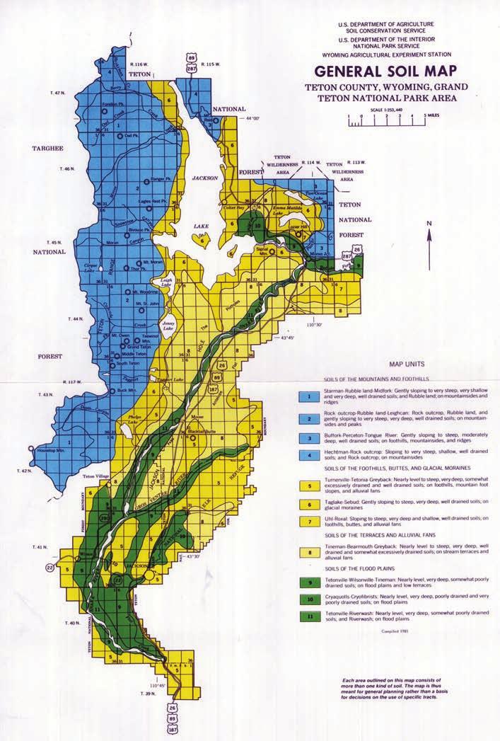
9 2) Topography (LS) The size, shape, and slope of the land greatly influence the amount of runoff a site will experience. The effect of topography on erosion is accounted for by slope length and slope steepness. Soil loss increases more with slope steepness than it does with slope length. The LS factors for a uniform slope are determined by looking at a standard Topography (LS) table. For more information on topography in Teton County, WY please visit 3) Soil Erodibility (K) Soil erodibility is a complex property and is thought of as the ease with which soil is detached by splash during rainfall, by surface flow, or both. The vulnerability of soil to erode is determined by soil characteristics: particle size, organic content, soil structure, and soil permeability. K factors are determined by soil erodibility nomographs (Fig. 2). Particle Size: Soils that contain high proportions of silt and very fine sand are generally the most erodible. The least erodible soils contain high percentages of organic matter, strong subsoil structure, and high In Teton County, the valley floor has poorly developed soils with a high proportion of rounded cobblestones from softball to basketball size. Organic Matter: Organic matter creates favorable soil structure, improves fertility, increases infiltration, delays the start of erosion, and promotes good soil microbes. permeability. Clay will act as a binder in soils and reduce erodibility. Once eroded however, clays stay in suspension for a long time and settle out slowly. Soil Structure: Organic matter, particle size, and gradation affect soil structure, which is the arrangement orientation and organization of particles into aggregates. Compaction on construction sites from heavy equipment can change the soil structure by destroying the soil conglomerates. As a Four major soil map units make up 40.5 percent of Teton County. The two major components of these four soil map units are Rubble land and Rock outcrop. They are found on mountainsides and foothills from 6,000-13,000 feet elevation. result, porosity and water holding capacity is reduced. It also diminishes the ability of native plants to take root because the roots experience difficulty breaking into the hard soil (See page 7 for General Soil Map for Teton County, WY). 5 Teton County is a high mountain valley with a terraced floor where there are many areas with steep or long slopes, which means that the potential for erosion will increase on those hillsides. In Teton County, there is very little organic matter content to the soils, which can make establishing new vegetation difficult and erosion more severe.
10 Soil Permeability: Soil permeability refers to the ease In some parts of Teton with which water percolates through a given soil. The County, the soils generally faster or better water percolates through a soil the less have a high infiltration rate because they erosion will occur. Sheet flow of water over vegetated consist of well drained to areas will slow water velocity and increase the excessively well drained chances to seep down into the soil thereby reducing sandy or gravelly soils. erosive forces. Infiltration makes water available to plants and recharges underground aquifers. Sheet flow over unvegetated disturbed areas will form rills then gullies and then channel erosion. Figure 1. NRCS Isoerodent Map of Wyoming: R Values Figure 2. NRCS Erosivity Index Zone Map of Wyoming: K Values For more information about soils in Teton County, please visit the Natural Resources Conservation Service Web Soil Survey at: 6
11 7

12 4) Vegetative Cover (C) Vegetation plays an extremely important role in minimizing erosion because the leaves shield soils from raindrop impact and the roots hold soil in place. Erosion can be significantly reduced In Teton County, trees will often grow on the north side of a slope and low-growing shrubs like sage will be on the southfacing slope. by limiting the removal of existing vegetation or phasing construction so that large areas of vegetation are not disturbed all at once. Mulching and replanting as soon as possible after disturbing an area can reduce erosion from wind and water and reduces maintenance on other Best Management Practices (BMPs). The C factor indicates how the cover management options will affect the average annual soil loss. Slope aspect also plays a part in re-vegetation. Generally, the north-facing hillsides in Teton County are more shaded which allows water and snow more time to sit on the surface and infiltrate into the soil, thereby supporting tree growth. For this reason, north facing slopes may be easier to re-vegetate in Teton County. South facing slopes get more direct sun and tend to be more arid with rockier and Teton County wildflowers. Photo: Lydia Dixon sandier soils. Therefore, a south-facing slope may be harder to re-vegetate than a north-facing slope and may require additional maintenance or irrigation to establish permanent vegetation. A construction site is not considered stabilized until all disturbed areas that have been built on, paved over, or a uniform vegetative cover with a density of 70% of the native background vegetative cover has been established. For more information about native plants for planting in Teton County, please visit the county s website at: tetonwyo.org or to view the Teton County Board of County Commissioner approved Teton County Native Plant Species List. 5) Conservation Practices (P) Conservation practices include any soil disturbing practice oriented on or near the contour that results in storage of moisture. These practices principally affect erosion and sedimentation by modifying the flow pattern, grade, or direction of surface runoff and by reducing the amount and rate of runoff. The most typical example of a conservation practice used during construction is surface roughening. The erosion conservation practice factor is the ratio of soil loss with certain conservation practice to that of no practice. 8
13 Regulatory Requirements & Permits It should be the goal of Teton Conservation District (TCD), local agencies, organizations, and individuals in the Teton County region to minimize the amount of sediment and other pollutants released into storm sewer systems, drainage ways, rivers, and other waters of the State, especially Class 1 waters and 303(d) listed streams. Small Construction Permit Obtaining a small construction NPDES permit for disturbances of 1-5 acres in WY is fairly simple. An acceptable SWPPP must be prepared before activites begin and kept on-site. BMPs must be installed. EPA requires inspections be completed once every seven days or once every 14 days and after 0.25 inches of precipitation. Self-inspections must be made by operators to ensure that storm water discharges from their facility do not cause surface water quality violations or water quality degradation of waters of the State. Operators must document their inspections and, if necessary, adjust BMPs to protect water quality. Protection measures must remain in place until the construction site is finally stabilized. Reports must be kept on file for three years after the issuance of the Notice of Termination (NOT). The State does not require submittal of any paperwork; it is simply understood that the contractor is covered by the Small Construction NPDES permit if they have taken the proper steps. If they are inspected and BMPs are found acceptable, they will be found in compliance. If noncompliance items are found by EPA, there is the potential of a substantial fine (possibly up to $37,500 per violation per day). Large Construction Permit The current large construction permitting system requires development of a SWPPP and submittal of a Notice of Intent (NOI). The NOI must be submitted 30 days prior to construction. WYDEQ officials review the NOI for completeness and if all requirements have been met, they will issue a Letter of Authorization (LOA) that grants coverage under the Large Construction General Permit for storm water discharges. Then the BMPs are installed, ground breaking begins, self-inspections start, and inspection reports are kept for three years after issuance of the Notice of Termination (NOT). 9 To view an interactive map showing water bodies in Wyoming that are listed on the State s 303(d) list and the State s Class 1 waters, please visit WYDEQ Storm Water Program website: state.wy.us/wqd/wypdes_ Permitting/WYPDES_Storm_ Water/stormwater.asp

14 Projects that may Discharge to Class 1 Waters Large construction activities that have the potential to discharge to Class 1 waters may be subject to a site visit by WYDEQ personnel prior to issuing coverage under this general permit. Site visits are weather-dependent and may delay coverage under this permit. For example, site visits will not typically be scheduled to areas with heavy snow cover and a visit may not always be possible within 30 days of an NOI and SWPPP submittal. Applicants should plan accordingly. Denial of Coverage WYDEQ will notify the applicant of the approval or disapproval of coverage under this permit within 30 days of receipt of the NOI. In the case of disapproval, the Administrator should specify in writing the reason(s) for the disapproval and action(s), if any, that the applicant can take to gain approval. Example of a clearly posted SWPPP in Teton County, WY. Photo: Rachel Daluge Individual Permit If, after evaluation of the NOI and any additional information requested for the evaluation, it is found that this general permit is not applicable to the operation, the application will be processed as an application for an individual permit. The applicant will be notified of the Administrator s decision to deny authorization under the general permit and require coverage under an individual permit. Additional information may be required and a minimum of 120 days will be required to process the individual application and issue the permit. For up to date information on small and large construction permits for Wyoming, visit the WYDEQ Storm Water Program webpage: wy.us/wqd/wypdes_permitting/wypdes_storm_water/stormwater.asp Town of Jackson, WY, Permits Submittal Requirements for Grading and Erosion Control Permits for the Town of Jackson Land Development Regulations (LDRs) require all land disturbing activities unless explicitly exempted in section to have a permit (See Town of Jackson LDRs, Article 4 Development Standards, 10
15 Division Grading and Erosion Control). An application for a grading and erosion control plan or grading and erosion control statement, whichever is applicable, as indicated in this Division, should be submitted to the planning director along with an application fee. Table in the LDRs presents a summary of the submittal requirements for land disturbances of various sizes on different slopes for sites with less than 41% impervious surface proposed on the lot. Any activity which proposes 41% or greater coverage by impervious surface requires a grading and erosion control plan. For additional permit information that may be required, visit the Town of Jackson, WY LDRs & Comprehensive Plan website at: com/government/development-regulations-comprehensive-p/ or call (307) Teton County, WY Permits Teton County requires Grading & Erosion Control Permits for large land disturbances or smaller disturbances on steep slopes. The purpose of the permit is to preserve natural resources; protect the quality of the waters of the State and County; and to Note: In Teton County, WY, Sage Grouse Core Area requirements may apply. Additional time to obtain permit coverage may be needed. For more information, please contact the Wyoming Game and Fish Department: (307) protect and promote the health, safety, and welfare of the people to the extent practicable by minimizing the amount of sediment and other pollutants carried by runoff or discharged from construction sites. For additional permit information that may be required, visit the Teton County, WY LDRs website at: or call (307) Other Permits Permits may also be required by the State (turbidity waivers) or federal agencies (404 permits). State issued WYPDES construction permits do not preempt or replace the authority of local agencies to prohibit, restrict, or control discharges of storm water to storm drain systems or other water courses in their jurisdiction. Work in wetlands and dredge/fill work, requires a US Army Corps of Engineer permit. Discharge of wash water, concrete washout, construction dewatering to surface water requires a WYPDES waste water permit. 11

16 Monitoring Requirements The practices and procedures identified in the SWPPP must be implemented prior to commencing construction activities that result in soil disturbance. All sediment and erosion control and other protective measures must be kept in effective operating condition. Inspection reports must be signed and certified by appropriate personnel as specified in the Construction General Permit and retained as part of the SWPPP. A running log of fixed/unfixed problems should be kept in order to document action or inaction on the part of the contractor. Problems should be corrected as soon as possible after the Example of an active construction project in Jackson, WY. Photo: Teton Conservation District inspection. Depending on which construction phase you are in determines how much time you have to repair BMPs. Always check with manufacture specifications and permit requirements. In Wyoming, inspections are required every 14 days and after every ¼ rain or snowmelt event. In periods of inactivity, a monthly inspection is required. In severe weather you may be able to postpone the inspection until such time as you can perform the inspection. Copies of the SWPPP, all other reports required by the permit, and the data used to complete the NOI must be kept for three years after final site stabilization. For up to date information on regulatory requirements and permits, please visit the WYDEQ Storm Water Program webpage at: deq.state.wy.us/wqd/wypdes_permitting/wypdes_storm_water/ stormwater.asp 12
17 Permit Approval Process Start yes Is disturbance more than one acre? no yes NPDES coverage not required Is disturbance 1-5 acres? Is disturbance greater than 5 acres? yes Develop full SWPPP, keep it on-site, and do weekly or every other week inspections. No NOI required. yes Develop a full SWPP, pay permit fee, and submit NOI to WYDEQ Pending Status: Submit copy of SWPPP upon WYDEQ request Permit approval or denial in 30 days. yes Did you get a Letter of Authorization? Was permit denied? yes Install BMPs, implement SWPPP, and monitor as required. no Notes: 1. Other permits may be required before building. The SWPPP is required to get the WYPDES permit. 2. Work in wetlands will require a US Army Corps of Engineers permit. 3. Wash water, concrete washout, construction dewatering (except accumulated storm water) requires a WYPDES waste water permit. 4. Operators must maintain documentation of inspections and adjust BMPs as needed. 13
 to WYDEQ which indicates that the entire site has achieved final stabilization.")
18 Termination of Coverage Operators of all construction activities that are 1.0 acre and larger must submit a Notice of Termination (NOT) to WYDEQ which indicates that the entire site has achieved final stabilization. Upon submission of the NOT, the operator loses authority to discharge storm water under the general construction permit. Final stabilization occurs after all the soil disturbing activities on the site have been completed and a uniform perennial vegetative cover with a density of 70% of the native background vegetative cover for the area has been established on all disturbed unpaved areas and areas not covered by permanent structures. Example of an active construction project in Teton County, WY. Photo: Rachel Daluge For examples of SWPPP Templates, visit EPAs Resources for Construction Activities page at: 14
19 SWPPP Design & Implementation The SWPPP is the primary tool for reducing erosion and preventing sediment loss from a construction site along with control of construction related chemicals and waste. The SWPPP consists of construction drawings and closely associated narratives that demonstrate the 10 elements of a construction SWPPP have been reflected. The Ten Elements of a SWPPP 1. Limit soil disturbance 2. Minimize soil erosion 3. Protect slopes 4. Minimize sediment loss from site 5. Control flow rates and stabilize channels 6. Establish construction access 7. Protect drain inlets 8. Control dewatering 9. Control waste and pollutants 10. Construction phasing & project management Each of these elements must be considered and included in the SWPPP design and process. The permit reviewer will be analyzing the plans to make sure the design has taken them into consideration. Specifications, design criteria, and calculations are cited on the BMP fact sheets and should also be taken into consideration in the design phase of the SWPPP process. 1) Limit Soil Disturbance Clearly establish clearing limits and provide a description of critical areas, natural drainage features, trees and other vegetation, and appropriate buffers that are to be preserved within the construction area. Plastic, metal, or stake wire fence may be designated on the plans for marking the clearing limits in the field. Phase clearing when possible. 2) Minimize Soil Erosion Exposed soils should be stabilized by application of effective BMPs that protect the soil from the erosive forces of raindrops, flowing water, and wind. Applicable practices include, but are not limited to: temporary and permanent vegetation (seeding/sodding), mulching, plastic covering, erosion control fabrics and matting, the early application of gravel base in areas to be paved, and dust control. Selected soil stabilization measures should be appropriate for the time of year, site conditions, and estimated duration of use. 15

20 Soil stockpiles must be stabilized and protected with sediment trapping measures. Spread soil over slopes as quickly as possible after disturbance and rip subsoil prior to topsoil application to prevent sliding. Linear construction activities such as right of way and easement clearing, roadway development, pipelines, and trenching for utilities should be conducted to meet soil stabilization requirements. Contractors should install bedding materials, roadbeds, structures, pipelines, or utilities and re-stabilize the disturbed areas to limit disturbed soil. The native topsoil and natural vegetation should be retained in an undisturbed state to the maximum extent practicable. 3) Protect Slopes Design and phase cut and fill slopes in a manner that will minimize erosion. Consider soil type and its potential for erosion. Reduce slope runoff velocities by reducing continuous length of slope with terracing and diversions. Reduce slope steepness and roughen surfaces. Divert upslope drainage and runon waters with interceptors at top of slope. Storm water from off-site should be handled separately from Check dams, like these made of stone, reduce velocity and sedimentation by restricting flow. Photo: Dallas Archibald storm water generated on-site. Diversion of off-site storm water around the site may be a viable option. Diverted flows should be redirected to the natural drainage location before or at the property boundary. Contain collected flows in pipes, slope drains, or protected channels. Check dams should be used within channels that are cut down a slope. 4) Minimize Sediment Loss from Site Prior to flowing off a constructions site, storm water runoff from disturbed areas should pass through a sediment basin or other appropriate sediment removal BMP. 16


21 BMPs intended to trap sediment on-site, such as sediment basins, should be designed for installation as one of the first steps in the construction process. The BMPs should be functional before other land disturbing activities take place. The construction General Permit requires (where feasible) a temporary or permanent sediment basin for common drainage locations that serve an area with 10 or more acres disturbed at one time. Design sediment basins so they can be cleaned out. Disturbed areas and vehicle paths should be treated appropriately to reduce generation of dust and minimize track out of sediment. 5) Control Flow Rates and Stabilize Channels Properties and waterways downstream from development sites should be protected from erosion resulting from increases in the volume, velocity, and peak flow rate of storm water runoff from the project site. Downstream analysis may be necessary if changes in offsite flows could impair or alter Photo: Teton Conservation District. Channel forming from erosive forces. conveyance systems, streambanks, bed sediment, or aquatic habitat. Temporary on-site conveyance channels should be designed to minimize erosion from the expected flow velocity of a two-year, 24-hour storm event for the developed condition. Stabilization to minimize erosion of channels, drainage ways, stream banks, outlets, and downstream reaches should be specified in the SWPPP. 6) Establish Construction Access Construction access and exit should be limited to one route if possible or two for linear projects. Minimize traffic to and from the construction site. Access points should be stabilized with big enough rocks to minimize the tracking of sediment onto roads. 17

22 Wheel wash or tire baths should be located on site, if applicable. Wash all vehicles before and after entrance to site. Make sure sediment from washing activities does not flow off site. A stabilized construction entrance with a wheel wash is especially encouraged in Teton County when the construction is taking place around noxious weed areas. Include a note similar to the following: Roads should be cleaned thoroughly at the end of each day. Sediment should be removed from roads by shoveling or pickup sweeping and transported to a controlled sediment disposal area. Street washing should be accomplished only after sediment is removed in this manner. 7) Protect Drain Inlets Storm drain inlets operable during construction (both existing and new) should be protected so that storm water runoff does not enter the conveyance system without first being filtered or treated to remove sediment. The protection afforded storm drain inlets should not be considered primary sediment control devices. The intent should be to minimize sediment arriving at the inlet. Inlet protection represents a last Exposed inlet with accumulated sediment due to improper inlet protection. Photo: Teton Conservation District line of defense for those cases where other erosion control and sediment control measures have been bypassed on a temporary basis. Special caution must be exercised when installing inlet protection on publicly traveled roads or in developed areas. Ensure that inlet protection is properly designed, installed, and maintained to avoid flooding of the roadway or adjacent properties and structures. Specify that inlets should be routinely inspected on a 14-day basis and immediately following storm events. Inlet protection devices should be cleaned or removed and replaced when sediment reaches one-third the height of the protection device. 18

23 8) Control Dewatering Foundation, vault, and trench dewatering should be regarded as storm water runoff and treated accordingly. The preferred method of treatment is discharge into a grassy swale and routing to a sediment basin. Highly turbid dewatering from clamshell digging, concrete tremie pour, or work inside the cofferdam should be handled separately from storm water. Disposal may require transport off-site in vehicles. Certain dewatering operations may require separate DEQ permits or US Army Corp permits and monitoring. 9) Control Waste and Pollutants All pollutants, including waste materials and demolition debris, that occur on-site during construction should be handled and disposed of in a manner that does not cause contamination of storm water, including covering or storing chemicals and potential pollutants in covered shed or areas to minimize exposure to storm water. Woody debris may be chopped and spread onsite as mulch. Cover, containment, and protection from vandalism should be provided for all chemicals, liquid products, petroleum products, and non-inert wastes present on site. Maintenance and repair of heavy equipment and vehicles involving oil changes, hydraulic system drain down, solvent and de-greasing cleaning operations, fuel tank drain down and removal, and other activities that result in discharge or spillage of pollutants to the ground or into storm water runoff must be conducted using spill prevention measures, such as drip pans. Contaminated surfaces should be cleaned immediately following any discharge or spill incident. Emergency repairs may be performed on-site using temporary plastic placed beneath, and if raining, over the vehicle. 19 Improved and expanded street sweeping operations help to keep pollutants out of waterways. Photo: Teton Conservation District. Bear-resistant waste containers are required in parts of Teton County, WY. For more information contact TC Planning and Development at (307)

24 Application of agricultural chemicals, including fertilizers and pesticides, should be conducted in a manner and at application rates that will not result in loss of chemical to storm water runoff. Manufacturer s recommendations for application rates and procedures should be followed. BMPs should be used to prevent or treat storm water runoff by contaminating ph sources. These sources include: bulk cement, cement in kiln dust, fly ash, new concrete washing and curing waters, waste stream generated from concrete grinding and sawing, exposed aggregate processes, and concrete pumping and mixture washout waters. Storm water discharges should not cause a violation of the water quality standard for ph in the receiving water. 10) Construction Phasing and Project Management Development projects should be phased where feasible in order to prevent the transport of sediment from the development site during construction. It allows smaller areas of disturbance at one time. Phasing also allows quicker re-vegetation to take place. There is also a recommended and logical order for installing BMPs. The Certified Professional in Erosion and Sediment Control program (CPESC, www. cpesc.org) recommends the following order for project management: 1. Install a construction access. 2. Install sediment traps and barriers such as silt fence and inlet protection. 3. Install runoff control measures such as diversions, perimeter dikes, water bars and outlet protection before grading. 4. Install runoff conveyance system (Stabilize streambanks, storm drains, and line channels). 5. Complete grading such as clearing, grubbing, cutting, and filling. 6. Install surface stabilization such as temporary and permanent seeding, sodding, and riprap. 7. Construct building and install necessary BMPs on as-needed basis. 8. Complete final stabilization where vegetation is fully established and BMPs are removed. 20 Straw wattles are used to trap sediment and promote infiltration. Photo: Rachel Daluge
 in this manual are considered the best conventional or best available technology for this area.")
25 Best Management Practices (BMPs) In order to address the requirements of pollution reduction at construction sites, a variety of techniques should be employed to reduce soil erosion, reduce site sediment loss, and manage construction generated waste. The Best Management Practices (BMPs) in this manual are considered the best conventional or best available technology for this area. Most of the BMPs in this section come directly from Wyoming Department of Transportation (WYDOT) Standard Drawings and Specifications. Many are active and visible in Teton County on current WYDOT road construction project sites ( live/sites/wydot/files/shared/construction/wydot%20storm%20water%20 Field%20Guide% pdf). There are also additional BMPs listed that are not WYDOT-standard but are included because they offer more options for residential and commercial construction applications. Pages 22 and 23 will help the SWPPP preparer select the proper BMPs. They are classified into the following four categories: 1. Sediment control 2. Runoff control 3. Soil stabilization 4. Materials and waste management This section provides design specifications for a variety of Best Management Practices (BMPs) that work well in Teton County, WY. Hydroseeded slope to prevent wind and rain erosion. Photo: Dallas Archibald The BMP fact sheets on pages of this guide provide detailed information about the structure and design of the specific BMP. The BMP selection guide can be used in conjunction with the fact sheets to determine the best BMPs for each project site. It should be noted that the goal of a SWPPP is to retain soil on site. 21
26 BMP Selection Guide Sediment Control Retain Sediment Sediment Basins/Traps Ditch with Check Dams Sediment Trap/Basin Filter Sediment Sediment Filters Inlet Protection Silt Fence Mud and Dust Control Stablized Construction Entrance Dust Control Organic Filter Berm Divert Runoff Diversions Contour Ditch Diversion Dike/Dam Runoff Control Convey Runoff Waterways Channel Protection Cut to Fill Slope Transition Intercept Groundwater Enclosed Drainage Slope Drain Stabilize Outlet Outlets Rock Outlet Protection Level Spreader 22
27 Vegetative Buffer Temporary Seeding Soil Stabilization Graded Areas Vegetative Soil Cover Non-Vegetative Soil Cover Permanent Seeding Sodding/Hydroseeding Preservation of Existing Vegetation Erosion Control Blanket Topsoiling/Mulching Slopes Structural Retaining Wall Surface Roughening Slope Terracing Debris & Trash Management Covered Dumpsters Recycling Materials & Waste Management Non-Hazardous Waste Hazardous Waste Concrete Waste Management Sandblasting Waste Management Chemical Management Designated Disposal Areas Provide Washout Area Blast on Low-Wind Days Dust Collection Hoppers & Barrels Covered Storage Areas Bermed Storage Areas with Plastic Liners Implement SPCC Plan 23

28 BMP Fact Sheets Overview These fact sheets are designed to be used in conjunction with the BMP selection guide on pages 22 and 23 to come up with a sound construction management plan. In some cases, such as with ditch checks, the SWPPP preparer must determine which type of BMP would be most appropriate for the construction site. In the case of a ditch check, it would be appropriate to install erosion bale checks on some sites, while in other cases, the appropriate measure would be rock check dams. Although the symbol on the maps will look the same for both erosion bale ditch check dam and a rock (rip rap) check dam, the SWPPP narrative should specify which measure is being used and where. Legend symbology can be found through WYDOT and Certified Professional in Erosion and Sediment Control (CPESC) program publications. (See the Additional Resources section of this guide for more information.) Sediment Control Fact Sheets Ditch Checks Ditch checks are small barriers consisting of rock, erosion bales, excelsior logs, or a synthetic triangular silt dike. They reduce the velocity of small concentrated flows, provide a barrier for sediment, and reduce erosion potential. Primary Purpose/Use/Application/Suitability Ditch checks are used for long drainage swales or ditches to reduce erosive velocities. They are primarily used along roadsides with the type of ditch check dependent on the ditch width. Rock check dams are more suitable for narrow ditches and gullies or ditches with an odd contour. The contributing drainage area is normally 2-10 acres. Ditch checks should be placed close enough so that erosion between them is minimized or eliminated. Maintenance Requirements Inspect after every significant rainfall or every 14 days. Repair damage as needed. Check to make sure that flow is not bypassing or undermining the ditch checks. If this is happening, the design may need to be modified or a larger erosion issue may need to be addressed upgradient from the checks. 24 To download the following BMP Fact Sheets separately, please visit:

29 Remove accumulated sediment when it reaches approximately 1/3 the height of the dam or 12", whichever is less. Sediment Trap/Basin Sediment traps and basins are very similar in function. They both form ponding areas where sediment is allowed to settle out before water is discharged through a stabilized spillway. Sediment traps and basins detain runoff long enough to allow most of the suspended sediment to settle while still allowing for diffused flow of runoff. Primary Purpose/Use/Application/Suitability Sediment traps may be used on projects where the drainage area is less than 5 acres and are often temporary structures. Sediment basins are used for projects that drain disturbed areas of greater than 5 acres and can be incorporated as permanent features on the site, depending if a detention pond is needed long term. Normally sediment traps and sediment basins are excavated at the lowest elevation of a construction site where all the water ultimately collects before it leaves the site. Low rock embankments across a swale can also serve as a sediment trap. Sediment basins usually require more engineering than sediment traps and may include dewatering outlets, debris traps, or emergency spillways. For additional information on regulations, review the WYDEQs large and small construction permits. Maintenance Requirements Sediment basins should be designed, constructed, and maintained to minimize mosquito breeding habitats by minimizing the creation of standing water. They should be inspected after every significant rainfall or every 14 days. Debris and trash should be removed and the dewatering device should be unclogged as needed. Sediment should be removed and the basin regraded when the capacity of the impoundment has been reduced to 20% of its original storage capacity. For more information about this BMP, review sections and Appendix C of the WYDEQ Large Construction General Permit. 25


30 Inlet Protection Inlet protection consists of a variety of methods of intercepting sediment at storm water inlets through the use of excelsior logs, synthetic triangular dikes, or any other means that effectively removes sediment. Primary Purpose/Use/Application/Suitability Every inlet that is connected to a storm water system or has an outlet that discharges to waters of the State needs effective inlet protection. Common inlet protection devices include excelsior logs, erosion bales, and synthetic triangular traps. Maintenance Requirements Inspect after every significant rainfall or every 14 days. Repair damage as needed. Make sure sediment laden water is not by-passing between, around, or under the protection device. Sediment should be removed when it reaches approximately ½ of the height of the inlet protection device. Silt Fence A silt fence is a temporary linear sediment barrier consisting of geotextile fabric supported by mesh or other backing stretched between either wooden or metal posts. Silt fences reduce the velocity of runoff and allow sediment to settle. However, they do filter water very slowly and can cause ponding. When planning silt fence on a construction site, take ponding into account, especially when placing it at the toe of a hill or around stockpiles. Installation requires the silt fences are to be trenched in place. One of most common issues with silt fence is that it is not installed properly because it is not trenched in. Primary Purpose/Use/Application/Suitability Silt fences are designed to intercept sheet/overland flow and are not suitable for concentrated flow areas. Therefore, their use is limited to areas such as the toe of a slope, downslope of exposed soil areas, around temporary stockpiles, along streams and channels, and along the perimeter of a project. 26
.")
31 Silt fences are not recommended for use as a check dam in ditches because they cannot handle concentrated flows. The maximum tributary drainage area to a silt fence should not exceed 0.5 acres per 100 linear feet of fence. Silt fences are only to be used as a temporary BMP (3 to 6 months depending on manufacturer specifications). Maintenance Requirements Inspect after every significant rainfall or every 14 days. Repair damage as needed. The fabric should be checked for rips, tears, sagging, sediment by-passing and other types of deterioration. Sediment should be removed when it reaches approximately 1/3 of the height of the silt fence. Bury silt fence to a minimum depth of 6 inches. Check to make sure the bottom remains buried during routine inspections. Construction Entrance A stabilized construction entrance consists of a pad of crushed stone, recycled concrete, or other rock on top of a geotextile filter cloth, which facilitates the removal of sediment and other debris from construction equipment prior to exiting the site. This practice reduces mud and silt deposition on roadways and reduces the need for street sweeping. It can also help control on and off-site tracking of noxious weed seeds. Aggregate should be very coarse, a minimum of 2-3 inches, otherwise it will end up being tracked onto roadway. Primary Purpose/Use/Application/Suitability A stabilized construction entrance is required on all sites one acre or larger and is highly recommended for all construction sites. It is most effective when truck activity is directed to a single location for entering and exiting the site. A wheel wash rack, rumble strip, or rattle plates can be incorporated into the design to further reduce sediment tracking. Vehicle washing can also help control the release and spread of noxious weed seeds. 27

32 Maintenance Requirements Inspect after every significant rainfall or every 14 days. Repair damage as needed. When sediment has substantially clogged the void area between the rocks, the aggregate must be washed down or replaced. Periodic regrading and topdressing with additional stone may be needed to maintain efficiency. Dust Control Dust control and wind erosion control are important in Teton County because it is a semi-arid region. Wind erosion control consists of applying water and other dust palliatives as necessary to prevent erosion forces by wind. Covering stockpiles with materials like mulch, seed, or plastic is considered a dust erosion control device also. Primary Purpose/Use/Application/Suitability This practice is implemented on exposed soils and disturbed areas, especially areas where construction equipment is operating and stirring up soil. 28

33 Runoff Control Fact Sheets Organic Filter Berms Organic filter berms have several other names, such as compost berms or gravel and burlap bag berms, and are a widely adaptable management tool. Burlap bag berms are linear burlap tubes filled with material such as gravel, compost, mulch, and seed, sand, soil or other appropriate material. Organic filter berms are linear berms constructed of a mix of compost and mulch that is held together with a strong tackifier. Primary Purpose/Use/Application/Suitability The purpose of the burlap tubes is to divert water around a construction disturbance and into appropriately lined drainage structures. Burlap bag berms can be utilized in many places such as where road cuts are super elevated (banked) towards a significant fill slope, along the perimeter of a construction area to divert water around the whole site, below the toe of exposed and erodible slopes, around stockpiles, at the top of slopes to divert runoff away from exposed soils, and when construction sequencing requires the relocation of the berms fairly often. If the bag is filled with some type of organic material that would be suitable for the site, removal of the device is not necessary, as it will decompose naturally and add nutrients to the land. They do not require removal. Maintenance Requirements Inspect after every significant rainfall or every 14 days. Repair damage as needed. Silt must be removed when it reaches 1/3 the height of the berm. Contour Ditch Also known as an interceptor swale, a contour ditch is a small V-shaped, U-shaped, trapezoidal, or parabolic channel that collects runoff and directs it to a desired location. 29

34 Primary Purpose/Use/Application/Suitability Contour ditches are generally placed at the top of slope cuts greater than five meters high. They are also suitable for temporarily diverting water around a culvert while installing it. Some ditches are dug around an entire construction area to divert water away from the whole project (perimeter control). Sometimes contour ditches are used in conjunction with level spreaders at the downstream end of the ditch to redistribute water. Maintenance Requirements Inspect after every significant rainfall or every 14 days. Repair damage as needed. If the surface of the ditch is eroding, a channel liner or ditch checks should be added to help prevent soil erosion. Diversion Dike A diversion dike or dam is a soil mound which redirects runoff to a desired location. The dike is usually stabilized with ground cover, rock, or erosion matting. Primary Purpose/Use/Application/Suitability Diversion dikes have all the same applications as do burlap bag berms and contour ditches, except they are used specifically around chemical storage areas to contain spills. They are also able to withstand higher flow volumes than burlap bag berms and are more durable. Therefore, they are often constructed on sites with large amounts of off-site flow from neighboring properties. The diversion dam is basically like an upside-down contour ditch and is often used in conjunction with a contour ditch, based on topography. Maintenance Requirements Inspect after every significant rainfall or every 14 days. Repair damage as needed. Inspect the ground cover to make sure it is in good condition and no erosion is occurring on the face of the dam. Flatten or hydroseed if erosion is occurring. 30

35 Channel Protection Protecting a channel consists of lining a water conveying ditch with some type of non-erodible material so that when flow is concentrated in the channel, it will not erode. Channel protection includes a variety of erosion prevention techniques. Primary Purpose/Use/Application/Suitability Channel protection should be used in any channels that receive concentrated flow. Examples include: discharge from diversion dams or contour ditches and cut to fill slope transitions. Channels can be protected using geotextile liners or rock riprap that are designed to withstand the expected flow velocity within the channel. Maintenance Requirements Inspect after every significant rainfall or every 14 days. Repair damage as needed. Look for bare spots, sediment deposition, rills forming underneath blankets, and sediment filling up rip rap. Remove sediment and repair linings as necessary. Cut To Fill Slope Transition A cut to fill slope transition consists of a V-shaped rock lined ditch located between a hillside cut and the fill area where the soil from the cut is deposited. Primary Purpose/Use/Application/Suitability This BMP is unique to mountainous areas. The rock lined ditch provides erosion control on the slope between the cut and the fill areas. It is placed at the toe of a hillside cut where the ditch slopes to the fill area. The rock riprap should be sized based on anticipated flow velocity. Maintenance Requirements Inspect after every significant rainfall or every 14 days. Repair damage as needed. 31

36 Slope Drains A pipe slope drain is a temporary or permanent pipeline utilizing flexible or rigid pipe that conveys runoff down unstabilized slopes. The drain is anchored on the upstream end with some form of headwall to limit erosion and secure the pipe. Other slope drains include any kind of lined channel that directs water down hill such as a wooden flume, a ditch lined with geotextile fiber, or a half round pipe. Primary Purpose/Use/Application/Suitability Pipe slope drains intercept surface water and direct it away from slope areas to protect cut or fill slopes. They are used on sites with long, unstabilized, steep slope areas that are subject to erosion from overland flow. Normally, slope drains are implemented with other BMPs such as diversion dams, to direct the flow into the pipe area. They are placed on hillsides on sites with large berms or roadway embankments. Maintenance Requirements Inspect after every significant rainfall or every 14 days. Repair damage as needed. Check for clogging and scour. Remove built-up sediment from entrances, outlets, and within drains as required. Repair or rebuild deteriorated diversion dikes. 32


37 Rock Outlet Protection Rock outlet protection consists of a riprap apron at the bottom of pipe outlets and culverts that reduces water velocities in order to prevent scour at the outlet and soil erosion downstream. Primary Purpose/Use/Application/Suitability Outlet protection is needed where the velocity of the flow may cause erosion downstream, such as where a pipe outfalls onto a steep slope, the outlet discharges onto a gentle slope but has a significant drop to it, or outlets that have a continuous flow of water. Depending on soil erodibility and flow rates at the outlet, a geotextile fiber or erosion control blanket may need to be added beneath rip rap to reduce scouring and erosion potential. Maintenance Requirements Inspect after every significant rainfall or every 14 days. Repair damage as needed. Remove accumulated sediment from riprap when approximately half of the void space is filled with sediment. Inspect for scour beneath the riprap and around the outlet. Level Spreader Level spreaders are also referred to as infiltration ditches. They are square, long, narrow trenches filled with clean stone over a layer of sand. Primary Purpose/Use/Application/Suitability The purpose of this practice is to convert concentrated, potentially erosive flow to sheet flow and release it uniformly over a stabilized area or filter strip. The principal application of a level spreader is to convey water from impervious surfaces, such as parking lots, uniformly onto vegetated filter strips. Level spreaders can also be used as outlets for diversion structures. Level spreaders are placed where runoff water can be released as sheet flow down a stabilized slope. 33


38 Soil Stablization Fact Sheets Temporary & Permanent Seeding When re-seeding disturbed areas in Teton County, an effort should be made to closely match the native vegetation that was removed. Vegetative re-growth must be 70% of original coverage in order to be considered stabilized by WYDEQ. There are different plants and biotic communities in Teton County each of which support specific wildlife. Each community can be broken down into smaller and smaller units with more and more specific trees and grasses. For a specific site recommendation, the local Natural Resources Specific TC, WY seed mixes can be found on Teton Conservation District s website: or by calling (307) Conservation Service (NRCS), a professional, consulting firm, or a reputable seed company should be contacted. For more information please visit the NRCS Plants Database at: Hydroseeding Hydroseeding typically consists of applying a slurry of wood fiber, seed, fertilizer, and stabilizing emulsion with hydro-mulch equipment, which temporarily protects exposed soils from erosion by water and wind. Photo: Rachel Daluge Primary Purpose/Use/Application/Suitability Hydroseeding is applied on disturbed areas requiring temporary stabilization until permanent vegetation can be established. In Teton County, hydroseeding of stockpiles and slopes may be appropriate before construction ceases for the winter season, especially if construction will continue in the spring. Slope lengths of feet can be treated. 34


39 Maintenance Requirements Inspect after every significant rainfall or every 14 days. Repair damage as needed. Check for rill erosion and proper coverage. Re-apply if necessary. Erosion Control Blankets An erosion control blanket is a degradable erosion prevention product that consists of a gridwork netting of synthetic material with biodegradable fibers such as coconut or excelsior woven in between. They are available in different thicknesses, sizes, and expected life spans. Primary Purpose/Use/Application/Suitability The purpose of this BMP is to hold seed in place and prevent erosion until vegetation is established on disturbed areas. Erosion control blankets are mainly used to protect slopes, embankments, borrow ditches, and drainages. Often they are used in conjunction with other sediment trapping BMPs such as silt fence. Maintenance Requirements Inspect after every significant rainfall or every 14 days. Repair damage as needed. Missing or loose anchors must be replaced. Slumping blankets must be straightened and re-stapled. Excess sediment must be removed. Topsoiling/Mulching Topsoiling is the application of enriched dirt to a disturbed area. Mulching consists of applying a mixture of shredded wood mulch, bark, or compost to an exposed surface. Make sure to buy topsoil from a reputable dealer to avoid noxious and invasive species infestations. 35

40 Primary Purpose/Use/Application/Suitability Topsoiling is usually used on areas that are meant to be permanently seeded later. The topsoil acts as a barrier to both wind and water erosion, especially if well tracked. Topsoil also provides an excellent seed bed. Mulching is often associated with landscaping and is meant to protect soil by reducing rainfall impact, increasing infiltration, and lessening the effects of wind. Topsoil and mulch are used in the same locations such as on stockpiles, slopes, any bare areas, and freshly seeded or planted areas. Topsoil or mulch is also applied when it is a bad time of year to seed. Maintenance Requirements Inspect after every significant rainfall or every 14 days. Repair damage as needed. Check for rill erosion. Retaining Wall A retaining wall is a vertical structural measure that protects slopes against scour and mass moving of soil. They are located on very steep slopes and are strong enough to hold large volumes of soil in place behind them. Retaining walls are made of poured in place reinforced concrete or mortarless reinforced-soil segmental concreteblocks. Primary Purpose/Use/Application/Suitability Retaining wall should be considered where slopes are 1:1 or steeper. Retaining walls can eliminate the need for steep slopes by accommodating large grade changes in a small distance. Retaining walls more than 4 feet in height should be designed by a professional engineer. Maintenance Requirements The expected life of a retaining wall ranges from years. Perform freeze thaw tests and compressive strength and absorption tests specified by an engineer. 36

41 Surface Roughening Surface roughening roughens a bare soil surface by mechanical means. Typically, a piece of construction equipment with treads tracks up and down the slope to create grooves in the soil that are parallel to the slope contours and perpendicular to the direction of runoff. Other means of soil roughening include sheepsfoot rolling, scarifying, stair stepping, and imprinting. Photo: Rachel Daluge Primary Purpose/Use/Application/Suitability The tracks reduce runoff velocity, increase infiltration, reduce erosion, and provide sediment trapping. All construction slopes require surface roughening, even if erosion control blankets, mulch, seeding, or other stabilization techniques are planned. Surface roughening should be done on every slope or disturbed area that can be safely accessed by equipment. It is often considered the first step in vegetative stabilization. Maintenance Requirements Periodically check slopes for rills and washes. Re-grade, re-roughen, and reseed if signs of erosion are present. 37

42 Materials and Waste Management Fact Sheets Debris and Trash Management Solid waste management procedures and practices are designed to minimize or eliminate the discharge of pollutants to the drainage system or to watercourses as a result of the creation, stockpiling, and or removal of construction site wastes. Primary Purpose/Use/Application/Suitability Solid waste management procedures and practices are typically implemented on all construction projects that generate solid wastes. By limiting trash and debris on site, storm water quality is improved along with reduced cleanup requirements. Solid wastes include but are not limited to: construction wastes including brick, mortar, timber, steel and metal scraps; sawdust, pipe and electrical cuttings; non-hazardous equipment parts; styrofoam and other materials used to transport and package construction materials; highway planting wastes, including vegetative material, plant containers, and packaging materials; litter including food containers, beverage cans, coffee cups, paper bags, plastic wrappers; and smoking materials including litter generated by the public. Collection, Storage and Disposal Wherever possible, minimize the production of debris and trash. Clearly display labels on trash containers and recycle containers with appropriate information. Keep debris and trash under cover in either a closed dumpster or other enclosed or covered trash receptacle to minimize contact with rain and runoff. Store waste materials away from drainage ditches, swales, fill slopes, and catch basins. Do not allow trash containers to overflow, empty on a regular basis. Outfit construction vehicles with magnets on the bottom to collect loose metal scraps and nails. In some areas of Teton County, bear resistant trash containers are required. 38

43 Education Educate all workers on solid waste storage and disposal procedures. Incorporate recycling and disposal information into regular safety meetings. Clearly post no littering signs on site. Concrete Waste Management These are procedures and practices that are designed to minimize or eliminate the discharge of concrete waste materials to the storm drain systems or watercourses. Concrete waste comes in 2 forms: 1) Excess fresh concrete mix including truck and equipment washing, and 2) Concrete dust and concrete debris resulting from demolition. Primary Purpose/Use/Application/Suitability Concrete waste management procedures and practices are implemented on construction projects where concrete is used as a construction material or where concrete dust and debris result from demolition activities. Collection, Storage and Disposal Temporary concrete washout facilities should be constructed above grade or below grade at the option of the contractor. Temporary concrete washout facilities should be constructed and maintained in sufficient quantity and size to contain all liquid and concrete waste generated by washout operations. (Review Section 3.2 and Appendix C of the WY Large Construction General Permit.) Temporary washout facilities should have a temporary pit or bermed areas of sufficient volume to completely contain all liquid and waste concrete materials generated during washout procedures. Pump excess concrete in concrete pump bin back into concrete mixer truck. Clearly label the washout station area with legible signs. Once concrete wastes are washed into the designated area and allowed to harden, the concrete should be broken up, removed, and disposed of in a proper landfill or recycle center. Washout areas should not to be placed in low drainage areas that could possibly mix with storm water or be placed near drainages, creeks, or streams. 39
.")
44 Education/Maintenence Educate all workers on concrete waste storage and disposal procedures. Incorporate recycling and disposal information into regular safety meetings. Clearly post signs designating the concrete washout area. Temporary concrete washout facilities should be inspected for damage (i.e. tears in polyethylene liner, missing sandbags, etc.). Damaged facilities should be repaired. Existing facilities must be cleaned, or new facilities must be constructed and ready for use once the washout is 75% full. Chemical Waste Management These procedures and practices are implemented to prevent and control spills in a manner that minimizes or prevents the discharge of spilled material to the drainage system or watercourses. Many construction and industial sites have a Spill Prevention Control and Countermeasure Plan (SPCC) that can serve as an appropriate chemical management plan. Any spill or release of more than 25 gallons, or which results in a visible sheen on water, or a visible deposit on the bottom of any water body, must be reported to the Water Quality Division of the Wyoming Department of Environmental Quality within 24 hours to the department s 24-hour telephone number ( ). An online reporting form is also available at (For more information, review section 10.9 of the WY Large Construction General Permit.) Primary Purpose/Use/Application/Suitability The objective of chemical management is to minimize the potential of storm water contamination from construction chemicals through appropriate recognition, handling, storage, and disposal practices. Education Train all workers on proper use of spill kits. Have all employees read the SPCC plan. Report spills of federal reportable quantities, in conformance with the requirements in 40 CFR parts 110,119, and

45 Post-Construction Storm Water Management If unchecked, increased impervious surfaces associated with development will increase stormwater volume and degrade water quality, which can harm water bodies. The best way to mitigate stormwater impacts from new developments is to use practices to treat, store, and infiltrate runoff on-site before it can affect water bodies downstream. Innovative site designs that reduce imperviousness and smaller-scale low impact development practices dispersed throughout a site are excellent ways to achieve the goals of reducing flows and improving water quality. Post-Construction BMPs Alternative Turnarounds Conservation Easements Eliminating Curbs and Gutters Green Parking Green Roofs Low Impact Development (LID) and Other Green Design Strategies Narrower Residential Streets Open Space Design Protection of Natural Features Riparian/Forested Buffer Grassed Swales Pervious Pavements Bioretention (Rain Gardens) Vegetated Filter Strip Stormwater Wetland This section was taken was from the US EPA s Post-Construction Stormwater Management in New Development and Redevelopment webpage. Additional information and fact sheets can be found at: stormwater/menuofbmps/index. cfm?action=min_measure&min_ measure_id=5 Innovative post-construction actions, such as using wetland sod, can reduce impacts to water quality. Photo: Intermountain Aquatics Inc. 41

 grant program for natural resource projects.")

46 CD, local agencies, T organizations, and individuals have conducted efforts to improve the quality of surface waters in Teton County, WY. These include the Flat Creek Watershed Plan, Karns Meadow Storm Water Wetland, water quality sampling on Fish Creek and other waterways, Residential Well Test Kit Cost-Share program, teaching lessons for adults and children, and conducting individual site visits to assist landowners. In addition, TCD offers a Technical Assistance & Cost Share (TAC) grant program for natural resource projects. If you are interested in learning more about these efforts please contact TCD at (307) or visit org. Local Efforts From Top: TCD staff teach children about water quality. TCD and USGS conducting water-quality sampling on Fish Creek in Teton County, WY. Karns Meadow Storm Water Treatment Wetland Project located along Flat Creek in Jackson, WY. Photos: Rachel Daluge 42
Building Better Storm Water Quality
 Building Better Storm Water Quality s Storm Water Pollution Prevention Guidelines for Development Construction Projects City of El Segundo 350 Main Street (310) 524-2380 El Segundo, California 90245 Introduction
Understanding Stormwater Pollution Prevention Plans (SWPPPs) (SWPPPS)
 (SWPPPS)") Understanding Stormwater Pollution Prevention Plans (SWPPPs) (SWPPPS) Definitions SWPPP: Storm Water Pollution Prevention Plan BMP: Best Management Practice(s) to control pollution IDNR: Iowa Department
Understanding Stormwater Pollution Prevention Plans (SWPPPs) (SWPPPS) Definitions SWPPP: Storm Water Pollution Prevention Plan BMP: Best Management Practice(s) to control pollution IDNR: Iowa Department
Appendix B Construction SWPPP Short Form
 Appendix B Construction SWPPP Short Form Projects falling within the thresholds listed below may use this short form instead of preparing a formal Construction Stormwater Pollution Prevention Plan (SWPPP).
MINNEHAHA CREEK WATERSHED DISTRICT BOARD OF MANAGERS REVISIONS PURSUANT TO MINNESOTA STATUTES 103D.341. Adopted April 24, 2014 Effective June 6, 2014
 MINNEHAHA CREEK WATERSHED DISTRICT BOARD OF MANAGERS REVISIONS PURSUANT TO MINNESOTA STATUTES 103D.341 Adopted April 24, 2014 Effective June 6, 2014 EROSION CONTROL RULE 1. POLICY. It is the policy of
The Good, The Bad, and The Ugly
 Overview The Good, The Bad, and The Ugly Stormwater Regulations for the Construction Industry Seminar March 20, 2012 Wendy Terlizzi Arizona Department of Transportation Office of Environmental Services
Earth Dikes and Drainage Swales
 Categories EC Erosion Control SE Sediment Control TC Tracking Control WE Wind Erosion Control Non-Stormwater NS Management Control Waste Management and WM Materials Pollution Control Legend: Primary Objective
Project Information. Check all that are applicable to the construction project site: RIPDES CGP (construction) RIPDES RGP (dewatering)
 RIPDES RGP (dewatering)") Compliance Assistance Program Checklist 1 Start of Construction Stormwater Self-Certification Checklist Note: This checklist must be completed and submitted to the DEM no later than 30 days after initiating
Compliance Assistance Program Checklist 1 Start of Construction Stormwater Self-Certification Checklist Note: This checklist must be completed and submitted to the DEM no later than 30 days after initiating
Storm Water Permitting Requirements for Construction Activities. John Mathews Storm Water Program Manager Division of Surface Water
 Storm Water Permitting Requirements for Construction Activities John Mathews Storm Water Program Manager Division of Surface Water Why Permit Storm Water? Impacts During Construction Not an issue until
Erosion Control Inspection Form
 Project Name Address Inspection Date Time Name of Certified Erosion Sediment Lead (CESCL) or qualified inspector if less than one acre Print Name: Approximate rainfall amount since the last inspection
Schedule A DISTRICT OF MAPLE RIDGE Watercourse Protection Bylaw
 Schedule A DISTRICT OF MAPLE RIDGE Watercourse Protection Bylaw 6410 2006 The Erosion and Sediment Control plan should seek (i) to protect the soil surface from erosion where possible and (ii) capture
Town of Friday Harbor PO Box 219 / Friday Harbor / WA / (360) / fax (360) /
 / fax (360) /") Town of Friday Harbor PO Box 219 / Friday Harbor / WA / 98250 (360) 378-2810 / fax (360) 378-5339 / www.fridayharbor.org LAND CLEARING, GRADING, OR FILLING PERMIT APPLICATION APPLICATION DATE GRD No. APPLICANT/FRANCHISE
Town of Friday Harbor PO Box 219 / Friday Harbor / WA / 98250 (360) 378-2810 / fax (360) 378-5339 / www.fridayharbor.org LAND CLEARING, GRADING, OR FILLING PERMIT APPLICATION APPLICATION DATE GRD No. APPLICANT/FRANCHISE
Single Family Residential Construction Erosion/Sediment Control Standards
 Single Family Residential Construction Erosion/Sediment Control Standards Introduction: This booklet contains standard plans and procedures sufficient for typical building construction. It is not intended
Storm Water Pollution Prevention Plan (SWP3) Checklist
 Checklist") . Summit Soil and Water Conservation District Storm Water Pollution Prevention Plan (SWP3) Checklist Modified from the Ohio EPA SWP3 Checklist (Revised January 2017) SITE NAME: REVIEWER: DATE RECEIVED:
. Summit Soil and Water Conservation District Storm Water Pollution Prevention Plan (SWP3) Checklist Modified from the Ohio EPA SWP3 Checklist (Revised January 2017) SITE NAME: REVIEWER: DATE RECEIVED:
City of Doral 8401 NW 53 rd Ter. Doral, FL 33166
 City of Doral 8401 NW 53 rd Ter. Doral, FL 33166 Project Address: (305) 593-6700 Permit Number: National Pollution Discharge Elimination System (NPDES) Construction Site Erosion and Sedimentation Control
Construction Phasing Bad
 Construction Entrances Construction Phasing Remove mud and dirt from the tires of construction vehicles before they enter a paved roadway. Propoerly size entrance BMP's for all anticipated vehicles. Make
City of Glendale Stormwater Management Plan Checklist
 City of Glendale Stormwater Management Plan Checklist Project: Title of Plan: Date: Date of Plan: Reviewer: Most Recent Revision: Criteria Yes No Identify a SWMP Administrator and an alternate - The SWMP
Rock Sock (RS) Rock Sock height.
 Rock Sock height.") Rock Sock (RS) SC-5 Description A rock sock is constructed of gravel that has been wrapped by wire mesh or a geotextile to form an elongated cylindrical filter. Rock socks are typically used either as
Rock Sock (RS) SC-5 Description A rock sock is constructed of gravel that has been wrapped by wire mesh or a geotextile to form an elongated cylindrical filter. Rock socks are typically used either as
Erosion & Sedimentation Control Policy
 Issue Date 10/22/2010 Page 1 of 8 Erosion & Sedimentation Control Policy Introduction: Soil erosion is the removal of soil by water, wind, ice or gravity and sediment deposition occurs when the rate of
STORM WATER POLLUTION PREVENTION PLAN TEMPLATE
 STORM WATER POLLUTION PREVENTION PLAN TEMPLATE Cover Page Certifications Project, Owner, Operator, SWPPP Preparer, Date, Project Dates Signed by RIDOT (Owner) and CONTRACTOR (as Operator) of Contents Introduction
Tips with Creation of your Erosion and Sediment Control Plan
 Tips with Creation of your Erosion and Sediment Control Plan By Chris Droste, CESCO Senior Erosion Control Specialist Westmoreland Conservation District Forming Your Narrative Use the DEP checklist. Page
Division of Water Quality (701)
") Division of Water Quality (701) 328-5210 stormwater@nd.gov March April 2018 1 Construction Permit Permit #: NDR10-0000 Reissued April 1, 2015 Expires March 31, 2020 2 Discharges Covered Stormwater Discharges
Division of Water Quality (701) 328-5210 stormwater@nd.gov March April 2018 1 Construction Permit Permit #: NDR10-0000 Reissued April 1, 2015 Expires March 31, 2020 2 Discharges Covered Stormwater Discharges
York County STORMWATER LUNCH & LEARN
 York County STORMWATER LUNCH & LEARN TOPICS Points of Exposure SWPPP's NOT's Construction Sequence Permanent BMP's Basin Details Major and Minor Modifications Construction Buffers Stabilization Questions
Construction Stormwater Best Management Practices
 Marin County Stormwater Pollution Prevention Program San Rafael, California November 12, 2015 Construction Stormwater Best Management Practices The mention or image of any product or service is for illustrative
Construction Best Management Practices Handbook BEST MANAGEMENT PRACTICES
 Construction Best Management Practices Handbook www.montereysea.org BEST MANAGEMENT PRACTICES 26 www.montereysea.org Construction Best Management Practices Handbook VEHICLE TRACKING AND DUST CONTROL IN
Typical Local Erosion Control Requirements (Storm Water Management Authority, Inc.)
") Module 2: Selection of Controls and Site Planning for Construction Site Erosion Prevention Robert Pitt Department of Civil, Construction, and Environmental Engineering University of Alabama Tuscaloosa,
Module 2: Selection of Controls and Site Planning for Construction Site Erosion Prevention Robert Pitt Department of Civil, Construction, and Environmental Engineering University of Alabama Tuscaloosa,
APPENDIX C EROSION AND SEDIMENTATION CONTROL STANDARDS
 APPENDIX C EROSION AND SEDIMENTATION CONTROL STANDARDS City of Bradenton January 2017 1 INTRODUCTION This appendix to the City of Bradenton Department of Public Works and Utilities Utility Specifications
Chapter 2: Selecting Best Management Practices (BMPs)
") Chapter 2: Selecting Best Management Practices (BMPs) 2.1 - Temporary versus Permanent BMPs The same level of care should be taken to select both temporary BMPs and permanent BMPs. The same level of care
Chapter 2: Selecting Best Management Practices (BMPs) 2.1 - Temporary versus Permanent BMPs The same level of care should be taken to select both temporary BMPs and permanent BMPs. The same level of care
SE-6 GRAVEL BAG BERM. Objectives. Potential Alternatives
 Objectives Erosion Control - EC Sediment Control - SE Tracking Control - TC Wind Erosion Control - WE Non-Storm Water Management - NS Materials and Waste Management - WM DESCRIPTION AND PURPOSE A gravel
PART 1 GENERAL REQUIREMENTS
 PART 1 GENERAL REQUIREMENTS Contract Closeout Plan 110 Arrow diagram for project close-out...3 Erosion Control 121 Straw bale barrier... 5 122 Silt fence... 7 123 Diversion dike... 9 124 Inlet protection...
No. 6 December, Wisconsin s Forestry Best Management Practices for Water Quality Forest Roads
 No. 6 December, 1995 Wisconsin s Forestry Best Management Practices for Water Quality Forest Roads Steve Holaday, Wisconsin Dept. of Natural Resources, and Jeff Martin, Dept. of Forestry, UW-Madison BMPs
2-16 EROSION, SEDIMENT & STORM WATER CONTROL REGULATIONS APPENDIX B1
 2-16 EROSION, SEDIMENT & STORM WATER CONTROL REGULATIONS APPENDIX B1 There are three ways to accomplish urban soil erosion and sedimentation control: Allow erosion to take place and then control sediment
Construction Site Inspections
 Construction Site Inspections Keep The Mud Out of The Creek Barry Tonning, Tetra Tech Inspections help to identify and correct problems! Inspection requirements Must inspect site every 14 days (LA) Some
ADDENDUM NUMBER TWO. A. SECTION ADVERTISEMENT FOR BIDS 1. REVISE Sealed Bid Date/Time/Location paragraph to read as follows:
 DIVISION 00 - PROCUREMENT AND CONTRACTING REQUIREMENTS SECTION 00 91 11.02 ADDENDUM NUMBER TWO June 22, 2016 TO: PLANHOLDERS SUBJECT: PCT TRUCK STAGING PROJECT PROJECT NO. 091606 CONTRACT NO. 070287 This
SECTION EROSION AND SEDIMENTATION CONTROLS
 SECTION 312500 EROSION AND SEDIMENTATION CONTROLS PART 1 - GENERAL 1.01 GENERAL PROVISIONS A. Attention is directed to the CONTRACT AND GENERAL CONDITIONS and all Sections within DIVISION 01 - GENERAL
CITY OF CHICO. Erosion and Sediment Control Plan (ESCP) Worksheet for Small Construction Projects. Project Address: Building Permit Number:
 Worksheet for Small Construction Projects. Project Address: Building Permit Number:") CITY OF CHICO Erosion and Sediment Control Plan (ESCP) Worksheet for Small Construction Projects Project Address: Building Permit Number: What is this document for? The City s Phase II MS4 NPDES General
CITY OF CHICO Erosion and Sediment Control Plan (ESCP) Worksheet for Small Construction Projects Project Address: Building Permit Number: What is this document for? The City s Phase II MS4 NPDES General
EROSION AND SEDIMENTATION CONTROL SECTION 1 - GENERAL 1.1 SUMMARY
 31 25 00 EROSION AND SEDIMENTATION CONTROL SECTION 1 - GENERAL 1.1 SUMMARY A. Erosion and sedimentation control shall be provided by the Contractor for all areas of the site denuded or otherwise disturbed
City of West Sacramento Erosion and Sediment Control Plan (ESCP) Worksheet for Small Construction Projects
 Worksheet for Small Construction Projects") Erosion and Sediment Control Plan (ESCP) Worksheet for Small Construction Projects Project Name: Page intentionally left blank. - 2 - What is this document for? The City s Phase II MS4 NPDES General Permit
Erosion and Sediment Control Plan (ESCP) Worksheet for Small Construction Projects Project Name: Page intentionally left blank. - 2 - What is this document for? The City s Phase II MS4 NPDES General Permit
The Construction General Permit and Erosion Prevention and Sedimentation Control
 The Construction General Permit and Erosion Prevention and Sedimentation Control Presented at the Tennessee Gas Association Conference April 23, 2008 More than thirty years ago, two-third of the nation's
Stormwater Management. Cayuga County NY 20 July 2016 Presenter : John B. Zepko, CPESC
 Stormwater Management Cayuga County NY 20 July 2016 Presenter : John B. Zepko, CPESC Agenda What is Stormwater? Why is Stormwater a Problem? NY State Regulations Stormwater Pollution Prevention Plans What
Stormwater Management Permit Application LESS Than One Acre. Public Works Department st Ave East Kalispell, Montana (406)
") Public Works Department 201 1 st Ave East Kalispell, Montana 59901 (406) 758-7720 Note: This permit is separate from any permits required by the Montana Department of Environmental Quality. A State Stormwater
Public Works Department 201 1 st Ave East Kalispell, Montana 59901 (406) 758-7720 Note: This permit is separate from any permits required by the Montana Department of Environmental Quality. A State Stormwater
Best Management Practice (BMP) Guidance Manual
 Guidance Manual") Best Management Practice (BMP) Guidance Manual INTRODUCTION BMP examples in this guide provide ways to meet erosion and sediment control requirements. Best Management Practices are not limited to these
Best Management Practice (BMP) Guidance Manual INTRODUCTION BMP examples in this guide provide ways to meet erosion and sediment control requirements. Best Management Practices are not limited to these
Outline of Presentation. Inspecting Construction Site BMPs. Inspector. Back to Basics. Erosion Control. Erosion Control
 Inspecting Construction Site BMPs Kristin Kerr EOA, Inc. Outline of Presentation Back to Basics Erosion and Sediment Control Good Site Non-Stormwater Run-on and Run-off Control Construction Inspection
CITY OF CAMARILLO STORMWATER POLLUTION CONTROL PLAN Demolition or Stockpile Activity Under One Acre
 Approved by: City of Camarillo Stormwater Program Manager Date: CITY OF CAMARILLO STORMWATER POLLUTION CONTROL PLAN Demolition or Stockpile Activity Under One Acre Project Name: Project #: Project Location:
Appendix K: Soil Erosion and Sedimentation Control Plan Check List
 Appendix K: Soil Erosion and Sedimentation Control Plan Check List Drain Commissioner 46 February 2005 SOIL EROSION AND SEDIMENTATION CONTROL PLAN CHECK LIST Items listed below must be clearly depicted
Erosion and Sediment Pollution Control Guidelines for Residential Lots with soil disturbance of less than 1 acre (see exceptions)
") Adams Co. Conservation District 670 Old Harrisburg Road, Suite 201 Gettysburg, PA 17325 Telephone: 334-0636 Fax: 337-0730 www.adamscounty.us Erosion and Sediment Pollution Control Guidelines for Residential
Adams Co. Conservation District 670 Old Harrisburg Road, Suite 201 Gettysburg, PA 17325 Telephone: 334-0636 Fax: 337-0730 www.adamscounty.us Erosion and Sediment Pollution Control Guidelines for Residential
CITY OF JENKS EARTH CHANGE PERMIT APPLICATION
 CITY OF JENKS EARTH CHANGE PERMIT APPLICATION Any applicable State or Federal permits must be attached to this application or must be applied for with copies attached to this application if this permit
Suggested Stormwater Management Practices For Individual House Lots
 Suggested Stormwater Management Practices For Individual House Lots These practices are necessary to satisfy the water quantity and water quality criteria of the Rappahannock Stormwater Ordinance. These
Performance Standards Compliance Checklist
 Truckee Meadows Regional Stormwater Quality Management Program Performance Standards Compliance Checklist The checklist that follows identifies the BMPs that can be used at construction sites to meet each
Appendix A: SWPPP Template Instructions
 Appendix A: SWPPP Template Instructions To help you develop the narrative section of your construction site SWPPP, EPA has created this electronic SWPPP template. The template is designed to help guide
EXAMPLES OF GENERAL SOIL EROSION AND SEDIMENT CONTROL NOTES FOR HUNTERDON COUNTY, NJ
 EXAMPLES OF GENERAL SOIL EROSION AND SEDIMENT CONTROL NOTES FOR HUNTERDON COUNTY, NJ *THE BELOW NOTES ARE EXAMPLES OF COMMONLY USED IN SE&SC PLAN APPLICATIONS THE NOTES MAY BE EDITED AS APPROPRIATE FOR
2.1 MINIMUM WATER QUALITY PROTECTION REQUIREMENTS FOR DEVELOPMENT CONSTRUCTION PROJECTS
 2. Section 2 TW O SECTIONTWO 2.1 MINIMUM WATER QUALITY PROTECTION REQUIREMENTS FOR DEVELOPMENT CONSTRUCTION PROJECTS Unless specifically exempted, all Development Construction Projects will be required
Water Pollution Control for Work in Sensitive Areas
 Water Pollution Control for Work in Sensitive Areas 10-1. WATER POLLUTION CONTROL The Contractor is advised that failure to fully comply with the provisions of this Section, and all requirements listed
B. Install storm drain inlet protection to prevent clogging of the stormsewer and sediment loads to downstream stormwater facilities or waterbodies.
 The language provided in these specifications is meant to serve as a reminder and provide a generic example of the type of language that should be provided in final construction documents. This language
Town of Essex, Vermont January, 2017 Standard Specifications For Construction CHAPTER 3 EROSION AND SEDIMENT CONTROL
 CHAPTER 3 EROSION AND SEDIMENT CONTROL CHAPTER 3 EROSION AND SEDIMENT CONTROL Section 300 General Summary All projects constructed within the Town of Essex shall be constructed in strict accordance with
CHAPTER 8 EROSION AND SEDIMENT CONTROL PLAN REQUIREMENTS
 CHAPTER 8 EROSION AND SEDIMENT CONTROL PLAN REQUIREMENTS 8.1 INTRODUCTION To minimize the detrimental effects of erosion and sedimentation, Henrico County requires that those individuals responsible for
Diversion Dikes. Fe=0.95
 2.2 Diversion Dike Erosion Control Description: A diversion dike is a compacted soil mound, which redirects runoff to a desired location. The dike is typically stabilized with natural grass for low velocities
GENERAL SOIL EROSION AND SEDIMENT CONTROL NOTES FOR HUNTERDON COUNTY, NJ
 GENERAL SOIL EROSION AND SEDIMENT CONTROL NOTES FOR HUNTERDON COUNTY, NJ *THE BELOW NOTES ARE COMMONLY USED IN SE&SC PLAN APPLICATIONS THE NOTES MAY BE EDITED AS APPROPRIATE FOR PROJECT BEING DEVELOPED
CHAPTER 9 EROSION AND SEDIMENT CONTROL DESIGN
 CHAPTER 9 EROSION AND SEDIMENT CONTROL DESIGN Chapter Organization 9.1 Purpose... 9-1 9.2 Applicability... 9-1 9.2.1 Exemptions... 9-2 9.3 Design Criteria... 9-3 9.4 Erosion and Sediment Control (ESC)
SUDAS Revision Submittal Form
 SUDAS Revision Submittal Form Status Date: As of 3/15/2018 Topic: General Permit No. 2 updates Manual: Design Manual Location: Sections 7A-1 and 7B-1 Requested Revision: Section 7A-1 (General Information),
SECTION V CHAPTER 12 STORMWATER POLLUTION PREVENTION POLICY
 1. PURPOSE: SECTION V CHAPTER 12 STORMWATER POLLUTION PREVENTION POLICY The purpose of this policy is to establish procedures to facilitate compliance with federal, state and local stormwater regulations
Please print or type.
 SOIL EROSION AND SEDIMENTATION CONTROL PERMIT APPLICATION 6-18-07 Ann kjjkjkff- ANN ARBOR CHARTER TOWNSHIP 3792 Pontiac Trail, Ann Arbor, Michigan 48105-9656 Phone (734) 663-3418 Website: www.aatwp.org
NEW CASTLE CONSERVATION DISTRICT. through. (Name of Municipality) PLAN REVIEW APPLICATION DRAINAGE, STORMWATER MANAGEMENT, EROSION & SEDIMENT CONTROL
 PLAN REVIEW APPLICATION DRAINAGE, STORMWATER MANAGEMENT, EROSION & SEDIMENT CONTROL") NEW CASTLE CONSERVATION DISTRICT through (Name of Municipality) PLAN REVIEW APPLICATION DRAINAGE, STORMWATER MANAGEMENT, EROSION & SEDIMENT CONTROL Office use only: Received by Municipality: Received by
NEW CASTLE CONSERVATION DISTRICT through (Name of Municipality) PLAN REVIEW APPLICATION DRAINAGE, STORMWATER MANAGEMENT, EROSION & SEDIMENT CONTROL Office use only: Received by Municipality: Received by
CCSD#1 Stormwater Standards
 SECTION 6 EROSION CONTROL STANDARDS 6.1 INTRODUCTION The policies of this section shall apply during construction and until permanent measures are in place following construction as described herein, unless
D EROSION AND SEDIMENT CONTROL. Table of Contents
 Table of Contents D1. GENERAL... 1 D2. OBJECTIVE... 1 D3. REFERENCE MATERIAL... 1 D4. REGULATORY REQUIREMENTS... 1 D5. EROSION AND SEDIMENT CONTROL (ESC) PLANS... 2 D5.1 Goals and Objectives:... 2 D5.2
Suitable Applications Where concentrated flow of surface runoff must be conveyed down a slope in order to prevent erosion.
 Categories EC Erosion Control SE Sediment Control TC Tracking Control WE Wind Erosion Control Non-Stormwater NS Management Control Waste Management and WM Materials Pollution Control Legend: Primary Objective
Inlet Protection. Fe= (Depends on soil type)
") 3.4 DESIGN CRITERIA: KEY CONSIDERATIONS Evaluate drainage patterns to ensure inlet protection will not cause flooding of roadway, property or structures Never block entire inlet opening Size according
3.4 DESIGN CRITERIA: KEY CONSIDERATIONS Evaluate drainage patterns to ensure inlet protection will not cause flooding of roadway, property or structures Never block entire inlet opening Size according
Common Construction-Site BMPs Quick Reference Guide
 Common Construction-Site BMPs Quick Reference Guide Installation and Inspection Requirements For more information visit the Town of Truckee Clean Water Program Website: http://www.townoftruckee.com/engineering/clean-water-program
SECTION 11 PART I STORMWATER QUALITY PROTECTION Definitions / Acronyms 11-3 PART 1 CONSTRUCTION PRACTICES
 SECTION 11 PART I STORMWATER QUALITY PROTECTION CONTENTS Page 11-1 Definitions / Acronyms 11-3 PART 1 CONSTRUCTION PRACTICES 11-2 Stormwater Pollution Prevention Plan (SWPPP) 11-3 11-3 Erosion and Sediment
GRADING, EROSION AND SEDIMENTATION CONTROL
 SECTION 500 GRADING, EROSION AND SEDIMENTATION CONTROL 501 Erosion and Sedimentation Control Plan All engineering plans for projects that propose to construct new, or modify existing drainage facilities,
Storm Water Minimum Requirements #2 ENGINEERING DEPARTMENT th Street Anacortes, WA
 Storm Water Minimum Requirements #2 ENGINEERING DEPARTMENT 904 6 th Street Anacortes, WA 98221 www.anacorteswa.gov Official Use Only: (Information to Inspectors) Required Storm Water Facility and other
CORNERSTONE RIVER VALLEY VILLAGE FILING NO. 1 STORMWATER MANAGEMENT PLAN
 CORNERSTONE RIVER VALLEY VILLAGE FILING NO. 1 STORMWATER MANAGEMENT PLAN SITUATED IN THE SW ¼ OF SECTION 18, T.2S., R.67W., OF THE 6 TH P.M. COUNTY OF ADAMS, STATE OF COLORADO PREPARED FOR: Thornton Cornerstone
Section 208. SOIL EROSION AND SEDIMENTATION CONTROL
 208.01 Section 208. SOIL EROSION AND SEDIMENTATION CONTROL 208.01. Description. This work consists of installing and maintaining erosion and sedimentation controls to minimize soil erosion and control
WAKULLA SITE PLANNING
 WAKULLA CIVIL SURVEYING SITE PLANNING TRAFFIC CONTROL PLAN WAKULLA ARRAN ROAD WIDENING & RESURFACING UTILITY CONTACT LIST NO. DATE: APPR. REVISION: DATE: CIVIL SURVEYING SITE PLANNING GENERAL NOTES WAKULLA
Stormwater Erosion Control & Post-Construction Plans (Stormwater Quality Plans)
") Stormwater Erosion Control & Post-Construction Plans (Stormwater Quality Plans) Allen County Stormwater Plan Submittal Checklist The following items must be provided when applying for an Allen County Stormwater
Stormwater Erosion Control & Post-Construction Plans (Stormwater Quality Plans) Allen County Stormwater Plan Submittal Checklist The following items must be provided when applying for an Allen County Stormwater
SECTION EROSION AND SEDIMENTATION CONTROLS
 SECTION 312500 PART 1 GENERAL 1.01 GENERAL REQUIREMENTS A. Attention is directed to the CONTRACT AND GENERAL CONDITIONS and all Sections within DIVISION 01 - GENERAL REQUIREMENTS which are hereby made
C-1. Infiltration System
 C-1. Infiltration System Design Objective An infiltration system captures surface stormwater runoff and allows it to infiltrate into the soil. This SCM is typically the work horse of a runoff volume match
Block and gravel filters can be used where velocities are higher. Reduces the amount of sediment leaving the site.
 INLET PROTECTION From Massachusetts Erosion and Sediment Control Guidelines for Urban and Suburban Areas http://www.state.ma.us/dep/brp/stormwtr/files/esfull.pdf Definition: A sediment filter or an excavated
Contractors, Illicit Discharges, & Best Management Practices. Chris Allen Stormwater Inspector
 Contractors, Illicit Discharges, & Best Management Practices Chris Allen Stormwater Inspector What is an Illicit Discharge? Georgetown County Stormwater Ordinance defines an Illicit Discharge as: Any activity
LAND DISTURBANCE PERMIT
 SPRINGVILLE CITY Application Date: 110 South Main Springville, UT 84663 Permit Number: (801) 491-2780 Caselle #2208 Project Name: Project Address: LAND DISTURBANCE PERMIT Priority Site Owner s Name Phone
PHASE 1 UPDATES TO DESIGN AND CONSTRUCTION STANDARDS INITIAL DRAFT FOR. Chapter 6 EROSION PREVENTION AND SEDIMENT CONTROL
 PHASE 1 UPDATES TO DESIGN AND CONSTRUCTION STANDARDS INITIAL DRAFT FOR Chapter 6 EROSION PREVENTION AND SEDIMENT CONTROL Reader Notes (1/18/17 draft) CWS has drafted proposed changes to Chapter 6 to incorporate
SACHSE EROSION CONTROL GUIDELINES
 SACHSE EROSION CONTROL GUIDELINES Section I. Definitions The following words, terms, and phrases, when used in this guideline, shall have the meanings ascribed to them in this Section, except where the
Sediment Control Practices
 Sediment Control Practices SMP-05 Temporary Diversions, Berms or Ditches Symbol TD Description These temporary drains offer features such as conveyance for runoff down cut or fill slopes, subsurface drains
New Administration Building
 New Administration Building Stormwater Pollution Prevention Plan Hudson Valley Community College Troy, New York Prepared for: Hudson Valley Community College 80 Vandenburgh Avenue Troy, New York 12180
Re: Erosion Control Report and Drawings Requirements Accompanying Document
 Re: Erosion Control Report and Drawings Requirements Accompanying Document This document was created to help engineers and other design staff to better understand, meet and exceed the erosion control requirements
City of El Centro. Erosion and Sediment Control Plan Review Checklist. Reviewer: Review Date:
 City of El Centro Erosion and Sediment Control Plan Review Checklist Project: Reviewer: Review Date: If an item below is marked No, the Erosion and Sediment Control Plan (Plan) either does not provide
E & S Plan Approved. Not required but may be a municipal requirement** Not required but may be a. municipal. requirement** Not required but may be a
 Disturbed Area 0-5000 Sq. ft 5000 Sq. ft to less than 1 acre 1 to
Regulatory Requirements
 7B-1 Design Manual Chapter 7 - Erosion and Sediment Control 7B - Regulatory Requirements Regulatory Requirements A. National Pollutant Discharge Elimination System (NPDES) The Clean Water Act established
SUBSURFACE INFILTRATION SYSTEM DESCRIPTION. Alternative Names: Sump, Drywell, Infiltration Trench, Infiltration Galleries, Leach Fields
 4.1-d SUBSURFACE INFILTRATION SYSTEM Alternative Names: Sump, Drywell, Infiltration Trench, Infiltration Galleries, Leach Fields BMP DESIGN APPROACH Pollutant Source Control Hydrologic Source Control Stormwater
Home Remodeling Projects
 Should your project require a Standard Urban Stormwater Mitigation Plan (SUSMP), please see the City of Pomona s Standard Urban Stormwater Mitigation Plan (SUSMP) Pamphlet Best Management Practices For
APPENDIX C DURING CONSTRUCTION BMP TABLES
 APPENDIX C DURING CONSTRUCTION BMP TABLES Table C.1 Table C.2 Table C.3 Erosion Prevention BMPs Sediment Control BMPs Stormwater Runoff and Ground Control Measures STORM WATER QUALITY DESIGN MANUAL Appendix
General Permit No.: OHR Page 53 of 146
 Page 53 of 146 Part 8 Sector-Specific Requirements for Industrial Activity Subpart J Sector J Non-Metallic Mineral Mining and Dressing. You shall comply with Part 8 sector-specific requirements associated
ES Inspection and Maintenance of MS4 Structural Controls* Document Identification Number Date: March 14, 2018
 ES-301-4.08 Inspection and Maintenance of MS4 Structural Controls* Document Identification Number ES-301-4.08 Date: March 14, 2018 Document Owner: Kim Ohlson 1) Activity Description: MS4 Maintenance and
Richland County Department of Public Works Engineering (Land Development) Division
 Division") Richland County Department of Public Works Engineering (Land Development) Division Commercial Projects What is a Commercial Project? Projects that are not related to residential single family homes and/or
Richland County Department of Public Works Engineering (Land Development) Division Commercial Projects What is a Commercial Project? Projects that are not related to residential single family homes and/or
Shelbyville, KY Stormwater Best Management Practices
 5. Detention/retention volumes in the floodplain buffer shall count as fill if applied in a manner where off site floodplain storage volume is lost. 1.7 Residential and Home Owner Pollution Control Citizens
METROPOLITAN UTILITIES DISTRICT No Page: 1 of 10
 Page: 1 of 10 A. GENERAL Erosion control measures such as silt fence, inlet filters and soil stabilization blankets and matting, incorporated into underground pipeline construction projects, help prevent
Stormwater Pollution Prevention Plan Engineering Department Requirements
 Stormwater Pollution Prevention Plan Engineering Department Requirements The following are the stormwater pollution prevention plan requirements for the above referenced project. If you have any questions
Construction Site Runoff (CSR) Permit Application Permit Fee $150.00
 Permit Application Permit Fee $150.00") Construction Site Runoff (CSR) Permit Application Permit Fee $150.00 Site Address or Lot and Subdivision: Applicant Name: Applicant s E-Mail: Applicant s Address: Telephone: (office) City, State, ZIP (cell)
Construction Site Runoff (CSR) Permit Application Permit Fee $150.00 Site Address or Lot and Subdivision: Applicant Name: Applicant s E-Mail: Applicant s Address: Telephone: (office) City, State, ZIP (cell)
STORMWATER POLLUTION PREVENTION PLAN
 STORMWATER POLLUTION PREVENTION PLAN PART I GENERAL PROJECT INFORMATION - To be completed by Owner or Consultant PROJECT NAME: PROPERTY OWNER S NAME: ADDRESS: CITY: STATE: ZIP: PHONE #: FAX #: MOBILE #:
STORMWATER DISCHARGES ASSOCIATED WITH CONSTRUCTION ACTIVITY
 STATE OF COLORADO GENERAL PERMIT APPLICATION Updated 11/04 STORMWATER DISCHARGES ASSOCIATED WITH CONSTRUCTION ACTIVITY This application is for use by all stormwater dischargers engaged in construction
Paving and Grinding Operations
 Categories EC SE TC WE NS WM Erosion Control Sediment Control Tracking Control Wind Erosion Control Non-Stormwater Management Control Waste Management and Materials Pollution Control Legend: Primary Category