Greenhouse Gas Emission Reduction Strategies
|
|
|
- Godfrey Osborne
- 6 years ago
- Views:
Transcription
1 Greenhouse Gas Emission Reduction Strategies 2011 ITE Quad Conference April 18 19, 2011, Embassy Suites; Lynnwood, WA Victor L. Sl Salemann, PE Senior Associate David Evans and Associates Bellevue, WA

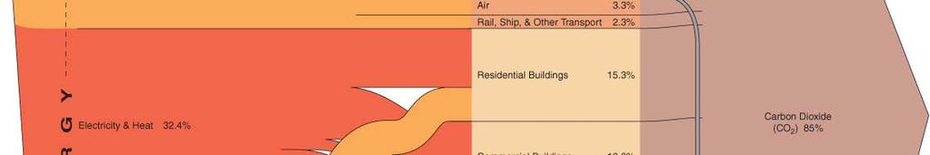

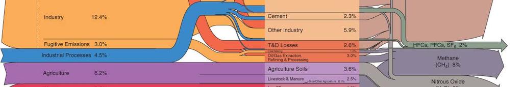
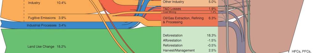
2 US GHG Emissions


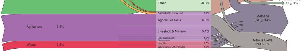
3 World GHG Emissions
4 One Ton of CO2
5 Why Care about GHG Modeling? Desire to understand VMT change with and without City Center Future alternative revenue sources for transportation Consistency with local and regional transportation planning policy Consistency with future green house gas emission policy

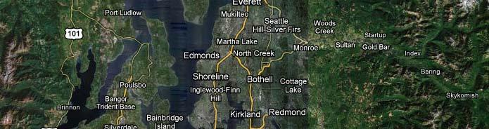

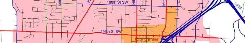
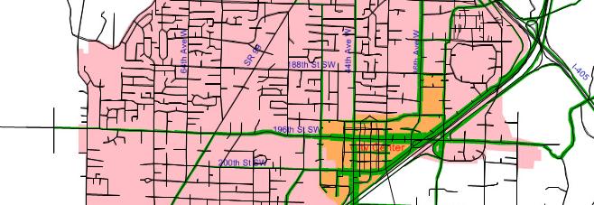
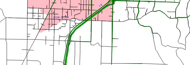
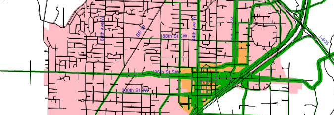
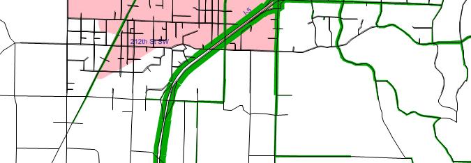
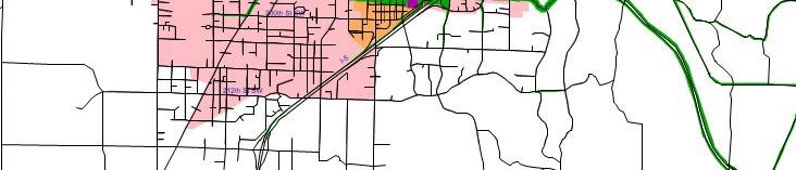
6 Lynnwood Vicinity Lynnwood

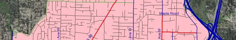
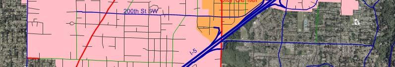
7 Lynnwood City Limits


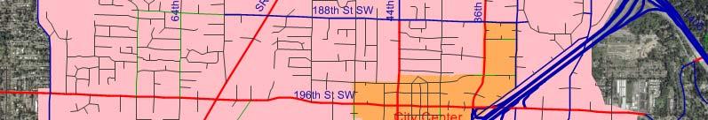
8 Lynnwood City Center ITE Quad Conference


9 City Center Concept Three Districts West End Residential Core Office and Retail North End Office and Retail Mixed Use (9.1 Million Sqft) 1.5 Million Sqft Retail 4.5 Million Sqft commercial and office 3,000 residential dwelling units 20 Year Plan Source: City Center Sub-Area Plan, City of Lynnwood, June 2010


10 City Center Roadway Improvements New street grid system in Core Area 7 lane Road on 196 th St SW and 44 th Ave W 5 Lane Road on 200 th St SW Adding New Signals and Pockets at Intersections 194 th St Pl SW Extension Source: City Center Street Master Plan, City of Lynnwood, 2009
11 Two Scenarios Tested Base Scenario: 9.1 Million Sqft mixed use land use Peanut butter spread outside the City Center but within Snohomish County No City Center Grid System No new road and intersection improvements around City Center Build Scenario: 9.1 Million Sqft mixed use development located in City Center area City Center Grid GidSystem New roadway and intersection improvements around City Center


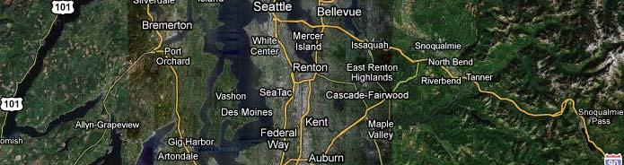
12 Lynnwood Travel Demand Model King and Snohomish Counties Included City-wide

13 No Build Trip Distribution


14 With City Center Trip Distribution


15 No Build 196 th St Flow Bundle


16 With City Center 196 th St Flow Bundle
17 GHG Emissions Analysis Vehicle Miles of Travel How many Trips? V = Vehicles Hog Long are the Trips? M = Miles Greenhouse Gas Emissions Total VMT by Vehicle Fuel type and consumption by Vehicle Emissions based on fuel consumption (delay ignored)
18 VMT Modeling Flow Chart


19 City Center Subarea VMT City Center: 2,717 or 28% PM Peak Hour VMT Increase Snohomish County Lynnwood King County


20 City of Lynnwood VMT Lynnwood Except City Center: 3,870 or 3.6% PM Peak Hour VMT Increase Snohomish County Lynnwood King County


21 Sub Regional VMT Outside Lynnwood and City Center: 8,900 or 0.6% PM Peak Hour VMT Decrease Snohomish County Lynnwood King County


22 Regional VMT Entire Region: 2,312 or 0.1% PM Peak Hour VMT Decrease Snohomish County Lynnwood King County
23 PM Peak Hour Alternative Mode VMT Alternative Mode Travel Leads to reduction of 2,500 PM Peak Hour Trips Transit Carpool Vanpool Bicycling and walking New bus service added to expansion of transit center leads to increase of 30 PM peak hour transit trips
24 PM Peak Hour VMT to Annual VMT Convert SOV PM peak hour VMT to Annual VMT K factor: Effective days per year: 300 days Heavy vehicle percentage: 2% Convert Alternative Mode PM peak hour VMT to Annual VMT PM peak hours last per day: 5 hours Effective days per year: 300 days Trip length: 5 miles/trip
25 Total Annual VMT Reduction
26 CO 2 Calculation 2
27 CO 2 Emissions Calculation Flow Chart 2
28 CO 2 Calculation Results 2
29 Conclusions Increased development in City Center results in more origins and destinations at the City Center; therefore the local VMT increases Trips from outside of the City Center decrease accordingly, which results in VMT decreases for the areas outside of the City Overall, regional VMT decreases slightly from both reduced travel demand and mode shift
30 Conclusions continued The build Scenario improves transportation efficiency for the surrounding region by concentrating jobs and homes in a high density urban center and reducing the need for residents to travel to neighboring cities for work, shopping, and other needs, which would thereby reduce future total VMT and the CO 2 emissions in the region compared to the No Build Scenario. The analysis demonstrates the VMT reduction benefits of encouraging transit trips by creating a transit oriented development.
31 Other Applications GHG impacts from delay reductions Intersection improvements (signals, roundabouts, interchanges) Arterial improvements (road diets, access management, new lanes) Does the delay reduction attract traffic in addition to reducing delay increasing demand and VMT? GHG impacts from corridor improvements VMT reduced by shorter more direct route VMT increased because of induced demand Results are usually regional
32 Acknowledgments City of Lynnwood Staff Jeff Elekes, Deputy Public Works Director David Mach, Project Manager Sandra Howe, Project Manager David Kleitsch, Economic Development Director
33 References Emission Facts, United States Environmental Protection Agency (EAP 420 f ), February 2005
34 Author s information Victor L. Salemann, Sr. Associate David Evans and Associates th Avenue SE Bellevue, WA voice vls@deainc.com Min Luo, Traffic Engineer David Evans and Associates th Avenue SE Bellevue, WA voice mxlu@deainc.com
VEHICLES MILES TRAVELED (VMT) TRAFFIC IMPACT METRIC
 TRAFFIC IMPACT METRIC") VEHICLES MILES TRAVELED (VMT) TRAFFIC IMPACT METRIC A project-specific quantified analysis of the MGA Campus has been undertaken to compare BAU to the project including the project s VMT reduction program
VEHICLES MILES TRAVELED (VMT) TRAFFIC IMPACT METRIC A project-specific quantified analysis of the MGA Campus has been undertaken to compare BAU to the project including the project s VMT reduction program
2006 TRANSPORTATION IMPACT FEES REPORT
 City of Bellingham 2006 TRANSPORTATION IMPACT FEES REPORT Prepared for: City of Bellingham September 2006 Prepared by: David Evans and Associates, Inc. 415 118th Avenue SE Bellevue, WA 98005 Phone: 425-519-6500
Integrated Land Use, Transportation & Air Quality Planning in the Sacramento Region
 Integrated Land Use, Transportation & Air Quality Planning in the Sacramento Region National Association of Regional Councils September 12, 2008 Matt Carpenter Sacramento Area Council of Governments 6
What is the Dakota County Principal Arterial Study?
 What is the Dakota County Principal Arterial Study? The Dakota County is underway and will address future designations of certain highways as Principal Arterials. What Are Principal Arterials? Principal
Contents i Contents Page 1 A New Transportation Plan Community Involvement Goals and Objectives... 11
 Contents i Contents 1 A New Transportation Plan... 1 Why develop a new plan?... 1 What area does the LRTP focus on?... 2 Why is this LRTP important?... 3 Meeting Requirements for Transportation Planning...
ALBION FLATS DEVELOPMENT EXISTING TRAFFIC CONDITIONS AND POTENTIAL IMPACTS
 EXISTING TRAFFIC CONDITIONS AND POTENTIAL IMPACTS FINAL REPORT SEPTEMBER 2010 TABLE OF CONTENTS 1.0 INTRODUCTION 1 2.0 EXISTING TRAFFIC CONDITIONS 2 3.0 FUTURE TRAFFIC CONDITIONS 3 4.0 POTENTIAL IMPACTS
STAFF REPORT. Planning Commission. Anjanette Simon, Associate Planner
 STAFF REPORT TO: Planning Commission HEARING DATE: May 23, 2012 FROM: APPLICATIONS: LOCATION: Anjanette Simon, Associate Planner ZMA2012-0005 (158th and Baseline Station Community High Density Residential
EXECUTIVE SUMMARY. The cities of Bellevue, Kirkland, Issaquah, and Redmond, commenced a two-year cooperative study in fall 2001 to
 EXECUTIVE SUMMARY STUDY PURPOSE The cities of Bellevue, Kirkland, Issaquah, and Redmond, commenced a two-year cooperative study in fall 2001 to describe and assess the four cities existing approaches to
IMPLEMENTING THE PLAN
 IMPLEMENTING THE PLAN SELECTED KEY MESSAGES 1. Protect the Core Functions. Assuming a stable revenue and cost scenario, the financial analysis indicates that there are likely enough resources to cover
2040 Transportation Policy Plan Conversion to Performance Based Planning Basis. 25 th Annual CTS Transportation Research Conference May 21, 2014
 2040 Transportation Policy Plan Conversion to Performance Based Planning Basis 25 th Annual CTS Transportation Research Conference May 21, 2014 1 About the plan Long-range transportation plan for the Twin
Appendix O Level of Service Standard and Measurements
 July 8, 2016 Appendix O. Appendix O Standard and Measurements Definition Level of service (LOS) is a mechanism used to determine how well a transportation facility is operating from a traveler s perspective.
2040 LAND USE WORKBOOK February 2017
 040 LAND USE WORKBOOK February 017 S A/C INTRODUCTION SITE SPOTLIGHT: WATERFRONT Through a series of community workshops and online activities in 016, Stockton community members shared their vision for
City of Los Angeles 2010 Bicycle Plan First Year of the First Five-Year Implementation Strategy & Figueroa Streetscape Project Draft EIR
 5.0 ALTERNATIVES California Environmental Quality Act (CEQA) requires that an EIR describe a range of reasonable alternatives to the project or to the location of the project that could feasibly avoid
Highest Priority Performance Measures for the TPP
 Highest Priority Performance Measures for the TPP The following list of measures are the highest priority performance measures as identified by modal working groups. These groups consist of staff from
Transportation Demand Management (TDM) Plan 2075 Broadway, Redwood City, CA
 Plan 2075 Broadway, Redwood City, CA") Transportation Demand Management (TDM) Plan 2075 Broadway, Redwood City, CA Prepared For: Lane Partners, LLC Prepared By: SANDIS 644 Menlo Avenue, Second Floor 636 9 th Street Menlo Park, CA 94025 Oakland,
Transportation Demand Management (TDM) Plan 2075 Broadway, Redwood City, CA Prepared For: Lane Partners, LLC Prepared By: SANDIS 644 Menlo Avenue, Second Floor 636 9 th Street Menlo Park, CA 94025 Oakland,
1.1 Purpose of the Project
 Chapter 1 Purpose and Need for East Link Project 1.1 Purpose of the Project The purpose of the East Link Project is to expand the Sound Transit Link light rail system from Seattle to Mercer Island, Bellevue
Unified Corridor Investment Study Performance Dashboard
 Unified Corridor Investment Study Performance Dashboard October 2018 Project Description Three parallel routes - Highway 1, Soquel/Freedom and the Santa Cruz Branch Rail Line - link the communities along
CHAPTER 2 - TRAVEL DEMAND MODEL DEVELOPMENT
 CHAPTER 2 - TRAVEL DEMAND MODEL DEVELOPMENT 2.1 EXISTING TRAVEL DEMAND MODEL In order to accurately project future year traffic volumes within this regional study area, it was first necessary to construct
Appendix F 2008 Travel Demand Modeling
 Appendix F 2008 Travel Demand Modeling TRAVEL DEMAND MODELING Purpose: The Jackson/Teton County Comprehensive Plan Update is revisiting land use and transportation planning policies to ensure they can
Performance Dashboard
 Unified Corridor Investment Study Performance Dashboard Step 2 Analysis Results DRAFT Revised 10/15/18 October 2018 Project Description Three parallel routes - Highway 1, Soquel/Freedom and the Santa Cruz
SOUND TRANSIT RESOLUTION NO. R Adoption of 1999 Regional Express Bus Service Plan BACKGROUND AND COMMENTS
 SOUND TRANSIT RESOLUTION NO. R99-15 Adoption of 1999 Regional Express Bus Service Plan BACKGROUND AND COMMENTS Meeting: Date: Type of Action: Staff Contact: Phone: Finance Executive 6/3/99 6/4/99 Recommend
Progress Report Regional Express & Bus Rapid Transit Program
 Progress Report Regional Express & Bus Rapid Transit Program ST Express Bus routes serve urban centers in Snohomish, King, and Pierce. March 2018 Prepared by Project Control & VE l Design, Engineering
CONNECTING LAND USE AND TRANSPORTATION PLANNING THE LINKAGE MODEL FOR METROPOLITAN PLANNING ORGANIZATIONS
 NEW YORK STATE ASSOCIATION OF METROPOLITAN PLANNING ORGANIZATIONS CONNECTING LAND USE AND TRANSPORTATION PLANNING THE LINKAGE MODEL FOR METROPOLITAN PLANNING ORGANIZATIONS Prepared by Chris O'Neill, CDTC
September Public Meetings. Developing a Blueprint for the Corridor
 September Public Meetings Developing a Blueprint for the Corridor Study Background Study initiated by the Commonwealth Transportation Board (CTB) and administered by VDOT in association with VDRPT. Addresses
Source: Utah Department of Transportation. Page 1
 SUMMARY The Los Angeles Departments of City Planning (DCP) and Transportation (LADOT) are updating the City s California Environmental Quality Act (CEQA) Transportation Section of the City s California
Performance Dashboard
 Unified Corridor Investment Study Performance Dashboard Step 2 Analysis Results DRAFT Revised 11/08/18 October 2018 Project Description Three parallel routes - Highway 1, Soquel/Freedom and the Santa Cruz
Appendix G Analysis of Project Impacts Compared to Existing Conditions
 Appendix G Analysis of Project Impacts Compared to Existing Conditions This page intentionally left blank. Analysis of Project Impacts Compared to Existing Conditions Introduction The analysis scenarios
10.0 Congestion Management Process
 Livability 2040 Regional Transportation Plan 10-1 10.0 Congestion Management Process 10.1 CMP Summary The identification and evaluation of projects for the Livability 2040 Regional Transportation Plan
Chapter 3: Growth Forecasts and Model Assumptions
 Chapter 3: Growth Forecasts and Model Assumptions A. Introduction A new transportation demand model was created in 2008 as part of the analysis that is the foundation of this plan. The City s transportation
GENERAL PLAN UPDATE. Joint Study Session April 13, 2017
 GENERAL PLAN UPDATE Joint Study Session April 13, 2017 Interrelated Issues and Topics Property Owner Requests Mobility: Efficiency and Safety Land Use Plan (in the City) Light Rail/ Transit Jobs/ Housing
Transportation 2040 Toward a Sustainable Transportation System. Toward a Sustainable Transportation System. Sultan Planning Board.
 1 Transportation 2040 Toward a Sustainable Transportation System Sultan Planning Board February 1, 2011 PSRC - Who We Represent 2 Our Region 4 Counties 82 Cities and Towns Urban & Rural Our Members Cities,
BAY MEADOWS II TRAFFIC MANAGEMENT PLAN
 FINAL BAY MEADOWS II TRAFFIC MANAGEMENT PLAN Prepared For: WILSON MEANY Four Embarcadero Center, Suite 3330 San Francisco, CA 94111 Prepared By: Original: March 17, 2008 Updated: December 4, 2012 Revised
6.0 CONGESTION HOT SPOT PROBLEM AND IMPROVEMENT TRAVEL DEMAND MODEL ANALYSIS
 6.0 CONGESTION HOT SPOT PROBLEM AND IMPROVEMENT TRAVEL DEMAND MODEL ANALYSIS 6.1 MODEL RUN SUMMARY NOTEBOOK The Model Run Summary Notebook (under separate cover) provides documentation of the multiple
Smart Growth Impact Fees
 Smart Growth Impact Fees Presentation to National Impact Fee Roundtable October 10, 2008 Deb Galardi, Galardi Consulting Donald Samdahl, Fehr & Peers Smart Growth and Impact Fees Enhanced ability to fund
report final Decennial Model Update Executive Summary Contra Costa Transportation Authority Cambridge Systematics, Inc.
 final report prepared for Contra Costa Transportation Authority prepared by with Dowling Associates Caliper Corporation June 2003 Table of Contents 1.0 Introduction... ES-1 2.0 Data Development... ES-5
Demand Reduction Assumptions Used For Travel Demand Analysis of EIS Alternatives
 M E M O R A N D U M Demand Reduction Assumptions Used For Travel Demand Analysis of EIS Alternatives TO: FROM: Project Management Team Steve Perone/PTV America DATE: Revised: February 6, 2009 Background
Measuring Success: Using data wisely for a healthier, wealthier, more equitable city. NACTO Conference, October 2013.
 Measuring Success: Using data wisely for a healthier, wealthier, more equitable city NACTO Conference, October 2013 Jeffrey Tumlin Commonly Used Performance Measures Source: Reid Ewing Old Speed Paradigm
FACT SHEETS SAN BERNARDINO COUNTY
 FACT SHEETS SAN BERNARDINO COUNTY WHAT IS THE REGIONAL TRANSPORTATION PLAN/ SUSTAINABLE COMMUNITIES STRATEGY (RTP/SCS) Every four years the Southern California Association of Governments (SCAG) prepares
Regional Performance Measures Annual Progress Report TPO Board - 2/4/2016 Presentation by: Chris Wichman, Senior Planner
 2015 TPO Board - 2/4/2016 Presentation by: Chris Wichman, Senior Planner Overview History and definition of performance-based planning & programming Review of 2015 TPO Board Action Requested 2 History
The Role of Transportation Systems Management & Operations in Supporting Livability and Sustainability
 The Role of Transportation Systems Management & Operations in Supporting Livability and Sustainability Michael Grant, ICF International February 7, 2012 NTOC Webinar Highlights of FHWA/FTA Primer Background:
Transportation Concurrency
 2015 Frequently Asked Questions About. Transportation Concurrency Q. What is Transportation Concurrency? A. Transportation Concurrency is both a State law requirement and a City pre-application development
Transportation Concurrency
 2017 Frequently Asked Questions About. Transportation Concurrency Q. What is Transportation Concurrency? A. Transportation Concurrency is both a State law requirement and a City pre-application development
BAY MEADOWS II TRAFFIC MANAGEMENT PLAN
 FINAL BAY MEADOWS II TRAFFIC MANAGEMENT PLAN Prepared For: WILSON MEANY SULLIVAN Four Embarcadero Center, Suite 3330 San Francisco, CA 94111 Prepared By: TABLE OF CONTENTS Executive Summary...4 1 Introduction...7
Federal Fiscal Year Iowa Clean Air Attainment Program Pre- Applications
 Federal Fiscal Year 2020 Iowa Clean Air Attainment Program Pre- Applications August 2018 TABLE OF CONTENTS Sponsor Project Title Page # Ankeny West 1 st Street Widening and Improvements 2 DART Euclid/Douglas
Appendix D: Functional Classification Criteria and Characteristics, and MnDOT Access Guidance
 APPENDICES Appendix D: Functional Classification Criteria and Characteristics, and MnDOT Access Guidance D.1 Functional classification identifies the role a highway or street plays in the transportation
APPENDIX H: TRAVEL DEMAND MODEL VALIDATION AND ANALYSIS
 APPENDIX H: TRAVEL DEMAND MODEL VALIDATION AND ANALYSIS Travel demand models (TDM) simulate current travel conditions and forecast future travel patterns and conditions based on planned system improvements
TSM/TDM (Transit and Roadway Efficiency) Concept - Analysis and Results
 Concept - Analysis and Results") M E M O R A N D U M TSM/TDM (Transit and Roadway Efficiency) Concept - Analysis and Results TO: FROM: Task Force and Oversight Team Steve Perone/PTV America Tim Burkhardt/CH2M HILL DATE: Revised: August
M E M O R A N D U M TSM/TDM (Transit and Roadway Efficiency) Concept - Analysis and Results TO: FROM: Task Force and Oversight Team Steve Perone/PTV America Tim Burkhardt/CH2M HILL DATE: Revised: August
Appendix L Greenhouse Gas 4-part Strategy
 Appendix L Greenhouse Gas 4-part Strategy Supplementary information regarding options for further reducing greenhouse gas emissions in the Puget Sound region State and Federal Greenhouse Gas Emissions
Appendix E Technical Description of the Modeling Framework
 Appendix E Technical Description of the Modeling Framework Appendix E Technical Description of Modeling Framework Appendix E Technical Description of Modeling Framework 1 In general terms, what analysis
APPENDIX A - PLANS AND POLICY REVIEW FEBRUARY 2017
 APPENDIX A - PLANS AND POLICY REVIEW FEBRUARY 2017 DENVERMOVES Transit Denver Moves: Transit APPENDIX A PLANS AND POLICY REVIEW 2035 Metro Vision Regional Transportation Plan (MVRTP) (2011) 2040 Fiscally
Transportation and Utilities
 4 Section 4 Transportation and Utilities 4.0 Introduction Transportation and utility systems are essential to accommodate and support development proposed in the Future Land Use Map. The following pages
Section 11: Transportation Strategies Toolbox
 Section 11: Transportation Strategies Toolbox A transportation strategies toolbox was developed to provide a systematic approach to identify potential strategies that address corridor transportation needs.
Planning Commission Study Session. Presentation
 Planning Commission Study Session Presentation Traffic Model Operation and Summary of the Rail Corridor Plan Traffic Study Results Traffic Model Background Examples of Analysis Techniques Traffic Study
LARKSPUR SMART STATION AREA PLAN. Public Workshop December 3, 2013
 LARKSPUR SMART STATION AREA PLAN Public Workshop December 3, 2013 0 PURPOSE OF Provide information about the regional planning context for the Larkspur Station Area, including Plan Bay Area, SMART, and
I-66 Corridor Improvements Outside the Capital Beltway in Northern Virginia, USA
 15th International Conference on Managed Lanes I-66 Corridor Improvements Outside the Capital Beltway in Northern Virginia, USA Case Study for Funding of Transit Service and Transportation Demand Management
Dear Board of County Commissioners, Mayor Flitner, and Town Councilors,
 May 27, 2015 Dear Board of County Commissioners, Mayor Flitner, and Town Councilors, Thank you for this opportunity to comment on the public review draft of the Integrated Transportation Plan (ITP). The
Appendix D Functional Classification Criteria and Characteristics, and MnDOT Access Guidance
 Appendix D Functional Classification Criteria and Characteristics, and MnDOT Access Guidance Functional classification identifies the role a highway or street plays in the transportation system. Some highways
TRANSPORTATION RELATIONSHIP TO OTHER ELEMENTS OF THE PLAN AND COUNTY REGULATIONS VISION FOR TRANSPORTATION PLANNING ROAD NETWORK SECTION 7
 TRANSPORTATION Like many growing western counties, Douglas County focuses on one of the most integral elements in land-use planning: transportation. The primary purpose of a transportation network is to
City of Tacoma TRANSPORTATION MASTER PLAN DRAFT
 City of Tacoma TRANSPORTATION MASTER PLAN 140 APPENDICES Appendix A Model Documentation MEMORANDUM Date: November 26, 2014 To: City of Tacoma, Department of Public Works From: Chris Breiland, Fehr & Peers
SR 710 Environmental Study
 SR 710 Environmental Study Alternatives Analysis s Technical Advisory Committee Meeting No. 5 May 9, 2012 1 1 Agenda > Recap of TAC Meeting No. 4 > Recommended alternative concepts for conceptual engineering
To Market, To Market. Discussion Contents. Part 1: Land Use & Infrastructure
 To Market, To Market Discussion Contents Part 1: Land Use & Infrastructure Internal Capture & Pass By Traffic Urban Calculations Rural Realities Case Study 1: Rural Pass-By Community Capture Case Study
MEMORANDUM #4. DATE: November 4, Warrenton TSP Project Management Team. Ray Delahanty, AICP, DKS Associates Kate Petak, EIT, DKS Associates
 MEMORANDUM #4 DATE: November 4, 2015 TO: FROM: SUBJECT: Warrenton TSP Project Management Team Ray Delahanty, AICP, DKS Associates Kate Petak, EIT, DKS Associates Warrenton Transportation System Plan Update
Performance Measures Workshop, May 18, 2017
 Measuring What Matters: Above and Beyond Requirements Performance Measures Workshop, May 18, 2017 Presentation Overview Background - origin and evolution of the Regional Outcomes Framework. Regional Outcomes
FACT SHEETS LOS ANGELES COUNTY
 FACT SHEETS LOS ANGELES COUNTY WHAT IS THE REGIONAL TRANSPORTATION PLAN/ SUSTAINABLE COMMUNITIES STRATEGY (RTP/SCS) Every four years the Southern California Association of Governments (SCAG) prepares a
MONITORING IMPLEMENTATION AND PERFORMANCE
 12 MONITORING IMPLEMENTATION AND PERFORMANCE The FAST Act continues the legislation authorized under MAP-21, which created a data-driven, performance-based multimodal program to address the many challenges
DES MOINES AREA MPO. Environment Roundtable. October 13, 2015
 DES MOINES AREA MPO Environment Roundtable October 13, 2015 October 13, 2015 Agenda 1. Call to Order 2. VOTE: Approval of Agenda 3. VOTE: Approval of Meeting Minutes 4. UPDATE: Water Trails 5. DISCUSSION:
Menlo Park Planning Commission Draft EIR Public Hearing June 20, 2016
 Menlo Park Planning Commission Draft EIR Public Hearing June 20, 2016 1 Purpose of Hearing Introduction to EIR Project Team Project Overview Draft Environmental Impact Report (EIR) Impacts and Mitigation
AIR QUALITY AND CLIMATE CHANGE EVALUATION GUIDANCE
 AIR QUALITY AND CLIMATE CHANGE EVALUATION GUIDANCE The following guidance provides additional details regarding the process followed by PSRC to evaluate projects for potential air quality benefits. As
ACTIVE TRANSPORTATION ADVISORY COMMITTEE. Memphis MPO March 30, 2015
 ACTIVE TRANSPORTATION ADVISORY COMMITTEE Memphis MPO March 30, 2015 Agenda Welcome & Introductions Announcements and Briefings Livability 2040: Regional Transportation Plan Congestion Management Process
US 1 Regional Growth Strategy Shaping the Region s s Future
 US 1 Regional Growth Strategy Shaping the Region s s Future Central Jersey Transportation Forum July 20, 2006 Route 1 Regional Growth Strategy Work Flow US 1 Regional Growth Strategy Base Year Conditions
EXAMPLES OF COMPREHENSIVE PLAN POLICIES HOW TO ESTIMATE THE BENEFITS OF THE CTR PROGRAM
 TABLE OF CONTENTS INTRODUCTION... I BACKGROUND OF THE COMMUTE TRIP REDUCTION EFFICIENCY ACT... II MAKING THE CONNECTION BETWEEN COMMUTE TRIP REDUCTION AND THE GROWTH MANAGEMENT ACT... IV CTR PLANNING AND
Quantifying the performance of a traffic data collection system: Scout Connect match rate evaluation
 Technology Showcase Miovision Scout Quantifying the performance of a traffic data collection system: Scout Connect match rate evaluation Contents Executive summary 2 Elements of the study 2 Objectives
9. TRAVEL FORECAST MODEL DEVELOPMENT
 9. TRAVEL FORECAST MODEL DEVELOPMENT To examine the existing transportation system and accurately predict impacts of future growth, a travel demand model is necessary. A travel demand model is a computer
2016 RTP/SCS Performance Measures Update Technical Working Group
 2016 RTP/SCS Performance Measures Update Technical Working Group March 19, 2015 Ping Chang & Naresh Amatya SCAG Staff Presentation Outline Background Evolving/Enhanced Performance Measures (PM) Framework
AMPO Annual Conference Session: Performance (Part 1) October 18, 2017 Savannah, GA
 October 18, 2017 Savannah, GA") AMPO Annual Conference Session: Performance (Part 1) October 18, 2017 Savannah, GA Introduction: North Jersey Transportation Planning Authority NJTPA Congestion Management Process Study Goals Analysis
AMPO Annual Conference Session: Performance (Part 1) October 18, 2017 Savannah, GA Introduction: North Jersey Transportation Planning Authority NJTPA Congestion Management Process Study Goals Analysis
ELEMENT M GROWTH MANAGEMENT
 Growth Management ELEMENT M GROWTH MANAGEMENT GOAL: To ensure that growth and development are integrally planned with, and phased concurrently with, the City of Irvine s ability to provide an adequate
CITY OF TEHACHAPI GENERAL PLAN Draft Environmental Impact Report
 City of Tehachapi CITY OF TEHACHAPI GENERAL PLAN Draft Environmental Impact Report SCH No. 2009101084 Prepared for: City of Tehachapi Community Development Department 115 South Robinson Street Tehachapi,
Chapter #9 TRAVEL DEMAND MODEL
 Chapter #9 TRAVEL DEMAND MODEL TABLE OF CONTENTS 9.0 Travel Demand Model...9-1 9.1 Introduction...9-1 9.2 Overview...9-1 9.2.1 Study Area...9-1 9.2.2 Travel Demand Modeling Process...9-3 9.3 The Memphis
Travel Demand Modeling At NCTCOG
 Travel Demand Modeling At NCTCOG Arash Mirzaei North Central Texas Council Of Governments For University of Texas at Arlington ITE Student Chapter March 9, 2005 Agenda Background DFW Regional Model Structure
Table II.B.3.1: Regional Trends, Concord-Kannapolis UA. Year Pct Ch Pct Ch
 3. Concord-Kannapolis-Rowan A. Regional trends The Concord-Kannapolis region, situated about 20 miles northeast of the greater Charlotte region, was until the 1970 s a largely independent region with a
MOBILITY 2025: THE METROPOLITAN TRANSPORTATION PLAN
 MOBILITY 2025: THE METROPOLITAN TRANSPORTATION PLAN Dan Lamers, P.E. North Central Texas Council of Governments Transportation Department www.nctcog.org/trans NORTH CENTRAL TEXAS COUNCIL OF GOVERNMENTS
New Climate for Transportation. How the City of San Diego and SANDAG must improve transportation to meet climate goals.
 New Climate for Transportation How the City of San Diego and SANDAG must improve transportation to meet climate goals. 2 N e w C l i m a t e f o r T r a n s p o r t a t i o n Acknowledgements Colin Parent
A.M. Peak Hour P.M. Peak Hour Land Use Intensity Daily Total In Out Total In Out. Shopping Center 236,160 SF
 April 23, 218 Mr. Michael Berenbom LANE4 Property Group, Inc. 475 Central Street Kansas City, MO 64112 RE: Dear Mr. Berenbom, French Market Trip Generation Overland Park, Kansas As requested, Priority
RD:VMT:JMD 09/09/2016 RESOLUTION NO.
 RD:VMT:JMD 09/09/2016 RESOLUTION NO. A RESOLUTION OF THE COUNCIL OF THE CITY OF SAN JOSE ADOPTING THE I-280/WINCHESTER BOULEVARD TRANSPORTATION DEVELOPMENT POLICY TO ADDRESS THE TRAFFIC IMPACTS OF PROJECTED
Growth in the Fresno Metro Area
 1 Growth in the Fresno Metro Area 2 A Unique Opportunity Meeting City and Regional Challenges SEGA 9,000 Acres 3 A Unique Planning Process Measuring Up to the Challenge Modeling the Impacts of Different
Los Angeles County Sustainability Summit Your Community: Smart Growth and Community Development
 Los Angeles County Sustainability Summit Your Community: Smart Growth and Community Development Barbara Dye The South Bay Cities Council Of Governments (SBCCOG) is a joint powers authority of 16 cities
Future Build Alternative Traffic Forecasts and Level of Service Analysis
 4.2.10 Future Build Alternative Traffic Forecasts and Level of Service Analysis For the five Build Alternatives, study intersections within one mile of potential station locations were analyzed, as it
Corridor Planning Standards + Potential Performance Measures
 Corridor Planning Standards + Potential Performance Measures January 17, 2007 1. Transportation improvements should connect people with potential places of employment and regional activity centers, particularly
Appendix G: Travel Demand Model Documentation
 Appendix G: Travel Demand Model Documentation Skagit Council of Governments TRAVEL DEMAND MODEL DOCUMENTATION August 2015 Prepared by: 11730 118 th Avenue NE, Suite 600 Kirkland, WA 98034-7120 Phone: 425-821-3665
County of El Dorado. El Dorado Hills Apartments Project Draft Environmental Impact Report. SCH No Prepared For: Prepared by:
 County of El Dorado El Dorado Hills Apartments Project Draft Environmental Impact Report SCH No. 2017042017 Prepared by: 505 14th Street, Suite 1230 Oakland, California 94612 Prepared For: County of El
VIA Long Range Plan Glossary
 VIA Long Range Plan Glossary Accessibility. Accessibility is the ability to reach opportunities (economic, social, etc.) within a certain geographical area. Americans with Disabilities Act (ADA). Passed
Midtown Corridor Alternatives Analysis. Technical Advisory Committee Meeting November 15, 2012
 Midtown Corridor Alternatives Analysis Technical Advisory Committee Meeting November 15, 2012 Today s Agenda Introductions Roles and Responsibilities Alternatives Analysis Process Overview Outreach Overview
DRAFT 2011 CLIMATE ACTION STRATEGY for the Surface Transportation Sector SAN FRANCISCO, CALIFORNIA
 DRAFT 2011 CLIMATE ACTION STRATEGY for the Surface Transportation Sector 03 03 2011 SAN FRANCISCO, CALIFORNIA 2 Outline of the talk 1. San Francisco at a glance 2. Proposition A city goals 3. What is sustainable
SECTION 5: ALTERNATIVES TO THE PROPOSED PROJECT
 City of American Canyon Broadway District Specific Plan Alternatives to the Proposed Project SECTION 5: ALTERNATIVES TO THE PROPOSED PROJECT 5.1 Introduction In accordance with CEQA Guidelines Section
Strategies to keep people and goods moving in and through Seattle
 Strategies to keep people and goods moving in and through Seattle Period of Maximum Constraint and the Permanent Viaduct Closure 2018-2024 West Seattle Transportation Coalition September 27, 2018 Department
Database and Travel Demand Model
 Database and Travel Demand Model 7 The CMP legislation requires every CMA, in consultation with the regional transportation planning agency (the Metropolitan Transportation Commission (MTC) in the Bay
APPENDIX B - GLOSSARY FEBRUARY 2017
 APPENDIX B - GLOSSARY FEBRUARY 2017 DENVERMOVES Transit Denver Moves: Transit - ii - APPENDIX B TRANSIT AND MOBILITY GLOSSARY Amenities, stop or station: Objects or facilities (such as a shelter, bench,
Central Phoenix Transportation Framework Study
 Central Phoenix Transportation Framework Study Study Area 2013, All Rights Reserved. 1 Agenda Introductions Work Products Feedback on previous products Draft products for Planning Partner review SR-30
The Role of Urban Goods in Sustainable Transportation Systems
 The Role of Urban Goods in Sustainable Transportation Systems Anne Goodchild Founding Director Supply Chain Transportation and Logistics Center Professor, Civil and Environmental Engineering Total U.S.
Transportation Model Report
 1. Introduction The traffic impacts of the future developments in the IL130/High Cross Road corridor for different scenarios were analyzed using a Travel Demand Model (TDM). A four step modeling process