!!!!!!HOT TOPIC!!!!!!! ARKANSAS UNDER CLIMATE CHANGE????? Water Again and?are extinctions important?
|
|
|
- Samson Adams
- 6 years ago
- Views:
Transcription
1 !!!!!!HOT TOPIC!!!!!!! ARKANSAS UNDER CLIMATE CHANGE????? Water Again and?are extinctions important?


2 Six Natural Regions of Arkansas Ozark region - flat-topped mountains, or plateaus, which have been eroded over millions of years. Arkansas River Valley mile wide trough carved by the river long ago, divides the Ozark and Ouachita Mountains. Ouachita Mountains largely covered in pine trees, includs Hot Springs and the diamond crater at Murfreesboro. Gulf Coastal Plain - once covered by the Gulf of Mexico 50 million to 100 million years ago. Includes agriculture and timber as well as oil and natural gas deposits. Delta, or Mississippi Alluvial Plain- the primary agricultural part of Arkansas. Includes swamps, prairies, and rich farmland. Crowley's Ridge - originally an Island between the Mississippi and Ohio rivers. Composed of windblown silt (loess).


3 North of Louisiana part of the Mississippi Drainage Basin 3rd largest drainage basin in the world, exceeded only by the Amazon and Congo. Drains 41 percent of the 48 contiguous states of the US. Covers more than 1,245,000 square miles. Includes all or parts of 31 states and two Canadian provinces.


4 Located in the Mississippi flyway, it is an important stopping area for large numbers of ducks, geese, shorebirds, blackbirds, sparrows, warbler and thrushes, "The duck hunting capital of the world." More than 70,000 duck stamps are sold in Arkansas every year, and more mallards are harvested in the state than in the rest of the Mississippi flyway.


5 Arkansas is the leading rice producing state in the U.S., representing 46.5% of the total U.S. production. Arkansas is home to the world's largest rice processing and exporting company, Riceland Foods, Inc., Producers Rice Mill, Inc. and 8 other rice milling companies.

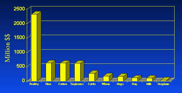
6 Leader in POULTRY and EGG production


7 America's First National River One of the few remaining rivers in the lower 48 states without dams. Traveling eastward through the Arkansas Ozarks into the White River.


8 The Grail Bird The Ivory Billed Woodpecker Last confirmed to have been seen alive in 1944 in Louisiana and last believed heard in the 1980s in Cuba. Believed to be extinct. Sighted in the Cache River National Wildlife Refuge (White River)
9 Fourth Assessment Report: "Climate Change 2007 Warming of the world s climate is unequivocal and is now evident from observations. Analysis of climate models with constraints from observations provides for better assessment of the climate response. There is now a higher confidence in projected patterns of warming and other regional scale features including changes in wind patterns, precipitation, and some aspects of extreme events.

10 North America to experience water stress especially in the west. Decreased snow pack, increased winter flooding, and reduced summer flows. Increased pests, diseases, and fires. Increased yields in agriculture by 5-20% with regional variability. Increased heat waves especially in urban areas. Increased vulnerability in coastal regions from sea level rise and increase in storm intensity.
11 Don Wuebbles, professor and executive coordinator of the School of Earth, Society, and Environment, at the University of Illinois at Urbana-Champaign. "If we look at the current climates in the U.S., what it means is that we're talking about a climate for the state of Illinois that's maybe more like eastern Texas by the end of the century. Or if we talk about Michigan or Wisconsin, we're talking about a climate that's maybe more like that in Arkansas by the end of the century," Precipitation won't be that much different, but there will be more in winter and spring and less in summer than at present, and when there is rainfall, it's more likely to come in a heavy storm. That means flooding is more likely to accompany rains, and the summers may have droughts. But what of Arkansas?????

12 Projected Heating deg deg

13 Generally less rain over Gulf of Mexico More rain over Upper Mississippi initially. 5-10% more rain In upper Miss basin 10-20% less rain In AK


14 12% drier by % drier by 2095
15 Warming over the US Southeast is projected. Precipitation change is more difficult to predict. Influence of El Nino Influence of the Gulf Generally thought that precip may increase in the short term then decrease as the century closes. Although average annual precip may not change much, an overall drier climate is expected because rainfall cannot compensate for evaporation. Severe events increase flood, drought, storms What are Arkansas Vulnerabilities????

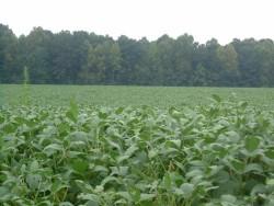
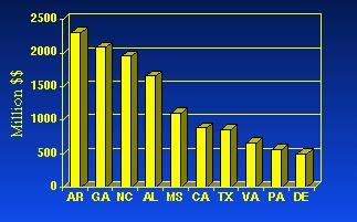
16 Arkansas 1 st in US rice production Rice started being grown in the Grand Prairie (Mississippi Alluvial Plain ) in A treeless plain with gentle relief, moderate climate, abundant groundwater, and a claycap that was resistant to percolation of irrigation water. Retains water in fields No recharge of aquifer


17 The rice was irrigated from the shallow Mississippi River Alluvial Aquifer. Rice Farming Areas As early as 1910, more water was being withdrawn from the aquifer than was being naturally recharged. By 1954, a cone of depression had developed in the water table surface that was 65 feet deep. From 1910 to 1958, the water table dropped an average of one foot per year.


18 Citizens have become concerned about the declining water levels, reduced well yields, and deterioration of the chemical quality of water in a number of areas.

 to define critical")
19 Critical Ground-Water Areas Pumping from the most productive aquifers in Arkansas, the Mississippi River Valley alluvial aquifer and the Sparta aquifer, has led to declining water levels throughout the Gulf Coastal Plain. These aquifers are the principal source of water for irrigation, industrial, and public supplies in this region. The State Legislature has passed a bill that allows the Arkansas Soil and Water Conservation Commission (ASWCC) to define critical groundwater areas when 50% of the water table has been depleted and to restrict water use within them.


20 Rice farmers are on the brink of draining one of Arkansas' biggest aquifers dry. The Army Corps of Engineers Plan 2 percent of water from the White River would be diverted for farm use, a project that would include pumping stations, canals and reservoirs $200 million in federal money, or about $300,000 a farmer. How Does The Aquifer Recharge??? The Arkansas, White, St. Francis, and Mississippi Rivers, are in hydraulic connection with the Mississippi alluvial aquifer. Recharge to the alluvial aquifer from these rivers becomes induced as ground-water level declines.
21 Some News Clips: "One could take the position that, hey, the farmers are the ones who created this mess, so why don't we just let their wells go dry and let everybody go broke, and then the problem will fix itself, but the critical problem is that right now, we're facing an imminent aquifer failure." Alan Perkins, a Little Rock lawyer and an authority on water law "Why should we subsidize a pump that will sell subsidized water to grow a subsidized crop?" "We see groundwater depletion in Arkansas being a major problem, and one that involves the national interest, and really the only federal agency with the expertise and ability to deal with it is the Corps," Earl T. Smith, chief of the Arkansas commission's water resources management division. Lower river flows could alter the habitats of certain fish and migratory birds, including ducks, and thus hurt fishing and hunting. Arkansas Wildlife Federation. It is time for the government to do in other states what has long been done in the West provide irrigation water to farmers who have no other resort. Nearly all sides agree that time for a decision is running short. Water levels in the shallow aquifer are declining at rates so fast that by 2015 there will not be enough left underground to sustain the area's farms. The economic impact of such a collapse could surpass $46 million a year, the Corps has estimated.


22 The U.S. poultry industry produces 6.12 million tons of manure per year from broilers, "It would make a row three feet wide by three feet high that would stretch twice across the country," Levels of nitrate are 1.5 to 10 times greater and phosphate are 1.5 to 3 times greater in six small agricultural watersheds than similar urban areas. Coliform levels often exceed safe swimming limits. The Arkansas and White Rivers recharge to the already stressed Mississippi alluvial aquifer.
 Nutrient Surpluss Areas Established: A geographic area where the soil Concentration of one or more nutrients is so high that the continued")
23 Oklahoma Sues Arkansas claiming Phosphorous pollution of 6 of its scenic rivers. Settelment (2003) Nutrient Surpluss Areas Established: A geographic area where the soil Concentration of one or more nutrients is so high that the continued application of Nutrients could negatively impact soil fertility and waters within the state.
 >130,000 homes were lost 700,000 people")
 Flood Control Act of")
24 What happens in the Mississippi Drainage Basin Effects Arkansas Flood of 1927 affected an area of 27,000 mi 2. (about the size of all the New England states combined) >130,000 homes were lost 700,000 people were displaced. 246 flood-related deaths reported. ~$350 million dollars in property damage (equivalent to ~ $5 billion dollars today) Flood Control Act of the world's longest system of levees was built.

25 The people and states upstream are linked inextricably to those downstream in the common destiny of a single water system. Role of soil moisture In the spring and summer of 1993, moisture from the soils in the southern states evaporated and was transported northward, where it produced more severe storms in the areas of greatest flooding.

26 More Frequent and Severe Storms: Arkansas may be susceptible to flooding from storms which hit Louisiana.
27 Animal Migration Patterns and Habitat (NWF) The mid-winter duck count has progressively decreased in Arkansas since the 1950 s. $118.3 M/yr is spent in migratory bird hunting. Warmer fall and winter temperatures in the north would make it unnecessary for waterfowl to fly as far south to find ice-free water. Projected to impact by as much as 50%. The breeding ranges of 31 species of songbirds, including 3 species of sparrows, 8 warblers, and 2 tanagers, could shift out of Arkansas forever due to climate change. Potential to expand the range of imported red fire ants. Northern movement of freshwater fish species Loss of tourism $$$$: $1.2B/yr


28 Arkansas forests expected to change dramatically: East to be overtaken by longleaf and slash pine Including the habitat of the Ivory Billed Woodpecker Adequate habitat is key to the bird s recovery USFWS West change to savannah 40-60% of Arkansas forrest could be replaced by grassland
29 Springtime is starting earlier, "Species that adapted to changes over millennia are now being asked to make those adaptations extremely quickly because of the swift rise in temperatures. We don't know how many will survive. We will lose species." Robert Hepworth, executive secretary of the Convention on Migratory Species, a treaty under the auspices of the U.N. Environment Program. Climate change can strike at each stage of their annual trek, from breeding ground to rest stops to their final destination. Global warming is the greatest threat to birds and other wildlife in Human history. Marnie Urso, Audubon Ohio 15-37% of all species may face extinction. Nature
30 Summary: A decrease in precipitation could further stress depleted aquifers and lead to higher levels of nutrient and bacterial pollution. Climate models predict a decline in rice production in the Mississippi Delta region of 20% by 2100.
31 Some Questions: 1. Who wins the water wars? Farmers vs Woodpeckers 2. Should we care about extinctions? Should we prioritize species? 3. Can we afford to wait for the development of new technologies such as carbon sequestration. 5. Which is scarier Global Change or Nuclear Energy? 6. Is Clean Coal an oxymoron?
The 6 Geographic Regions of Arkansas The Highlands 1. The Ozarks 2. The Arkansas River Valley 3. The Ouachita Mountains
 The 6 Geographic Regions of Arkansas The Highlands 1. The Ozarks 2. The Arkansas River Valley 3. The Ouachita Mountains The Lowlands 4. The Coastal Plain 5. The Mississippi Delta (Alluvial Plain) 6. Crowley
Home to about 56 million people, the Southwest includes Nevada, Arizona, New Mexico, Utah, Colorado and most of California.
 Climate change in the U.S. Southwest U.S. Environmental Protection Agency Overview The Southwest is the hottest and driest region in the nation. Extending from the Pacific Ocean east to the Rocky Mountains
Based on a presentation by Tim Asplund, Water Resources Specialist Wisconsin Department of Natural Resources
 IS IT CLIMATE CHANGE? Exceptionally low water levels have been observed recently at a large number of lakes in northwestern and north central Wisconsin. As of June 2007, monthly precipitation totals in
Building resilience to extreme weather events
 Building resilience to extreme weather events Scott Vaughan Federal / Provincial / Territorial Deputy Ministers of Agriculture Fall Retreat October 29 th, 2014 Toronto, Ontario www.iisd.org 2014 The International
How could we possibly change the Hydrologic Cycle on an Island as big as Vancouver Island?
 How could we possibly change the Hydrologic Cycle on an Island as big as Vancouver Island? Do you think for a moment that humans altering the Hydrologic Cycle would also change the Weather? Precipitation
13 Water: A Limited Resource
 13 Water: A Limited Resource Overview of Chapter 13 Importance of Water Water Use and Resource Problems Water Problems in U.S. and Canada Global Water Problems Water Management Water Conservation Water
Forestland Stewards 2018 Grant Slate
 NFWF CONTACT Jonathan Scott Program Director, Southern Forests jonathan.scott@nfwf.org 202-595-2609 Red-cockaded woodpecker Credit: Mary Snieckus ABOUT NFWF The National Fish and Wildlife Foundation (NFWF)
SECTION 1 FRESHWATER SYSTEMS UNIT 4: AQUATIC ECOLOGY
 SECTION 1 FRESHWATER SYSTEMS UNIT 4: AQUATIC ECOLOGY CENTRAL CASE STUDY: STARVING THE LOUISIANA COAST OF SEDIMENT LOUISIANA IS LOSING 25MI2 OF COASTAL WETLANDS ANNUALLY WETLANDS SUPPORT A DIVERSITY OF
Observed and Projected Temperature Rise
 Midwest Great Plains Regional Climate Impacts: Great Plains Observed and Projected Temperature Rise The Great Plains is characterized by strong seasonal climate variations. Over thousands of years, records
STAAR Science Tutorial 55 TEK 8.11D: Human Dependence on Ocean Systems
 Name: Teacher: Pd. Date: STAAR Science Tutorial 55 TEK 8.11D: Human Dependence on Ocean Systems TEK 8.11D: Recognize human dependence on ocean systems and explain how human activities such as runoff, artificial
WATERSHED. Maitland Valley. Report Card 201
 Maitland Valley WATERSHED Report Card 201 The Maitland Valley Conservation Authority has prepared this report card as a summary on the state of our forests, wetlands, surface water, and ground water resources.
Water Conservation Planning: How a Systems Approach to Irrigation Promotes Sustainable Water Use
 Water Conservation Planning: How a Systems Approach to Irrigation Promotes Sustainable Water Use Michael E. Sullivan and Walter M. Delp Natural Resources Conservation Service Little Rock, Arkansas michael.sullivan@ar.usda.gov
These values can be considered from the perspective of three hierarchical levels:
 Wetland Ecology Lectures 19-20 Wetland Values Wetland Values These values can be considered from the perspective of three hierarchical levels: Population Ecosystem Global Populations easiest value to identify
Unit III Nutrients & Biomes
 Unit III Nutrients & Biomes Nutrient Cycles Carbon Cycle Based on CO 2 cycling from animals to plants during respiration and photosynthesis. Heavy deposits are stored in wetland soils, oceans, sedimentary
Climate Change Water Implications for Michigan Communities, Landsystems and Agriculture
 Climate Change Water Implications for Michigan Communities, Landsystems and Agriculture Distinguished Senior Research Specialist Department of Geography Institute of Water Research Climate Change Summary
THE HYDROSPHERE PART 3
 THE HYDROSPHERE PART 3 Surface Freshwater: Rivers and Streams River is a large channel along which water is continually flowing down a slope; it is made of many streams that come together. Stream is a
Lecture 14. Water: A Limited Resource. Lecture 14
 Lecture 14 Water: A Limited Resource Lecture 14 1. Importance of Water 2. Water Use and Resource Problems 3. Water Problems in U.S. and Canada 4. Global Water Problems 5. Water Management 6. Water Conservation
Water Resources. The Water Cycle. Section 1. Key Terms surface water river system watershed groundwater aquifer porosity permeability recharge zone
 Water Resources The next time you drink a glass of water, think about where the water came from. Did you know that some of the water in your glass may have been part of a rainstorm that pounded Earth long
Questions and Answers about the Water Supply and Water Quality bond act for the November, 2018 ballot. Updated November 17, 2017
 Questions and Answers about the Water Supply and Water Quality bond act for the November, 2018 ballot. Updated November 17, 2017 What is the need for more State investment in water resources? What is the
Northwest Hydropower and Columbia Basin River Benefits Fast Facts
 Northwest Hydropower and Columbia Basin River Benefits Fast Facts 2013-14 Northwest RiverPartners is an alliance of farmers, utilities, ports and businesses that promotes: the economic and environmental
Three visions of the Mississippi River
 Three visions of the Mississippi River Ecological Settlement Infrastructural Systems Analysis: Hierarchical scale of interacting subsystems from the free services of nature to the commerce of regional,
Chapter 14 Water: A Limited Resource
 Chapter 14 Water: A Limited Resource I. Importance of Water A. Cooking & washing B. Agriculture C. Manufacturing D. Mining E. Energy production F. Waste disposal G. There are more people and individual
Walton Family Foundation Freshwater Initiative Strategy
 Walton Family Foundation Freshwater Initiative Strategy This document summarizes the five year strategy for the Walton Family Foundation s Freshwater Initiative. This strategy was adopted by the Foundation
Groundwater. Importance of Groundwater. The Water Table. Geol 104: Groundwater
 Groundwater Subsurface water contained in soil and bedrock. There is ~ 60 times as much water underground than in freshwater streams and lakes. Source of groundwater is rain and snow. Represents the infiltration
Water and Climate Change. David Coates Secretariat of the Convention on Biological Diversity Montreal Canada
 Water and Climate Change David Coates Secretariat of the Convention on Biological Diversity Montreal Canada Water and climate change How important is water? What do ecosystems have to do with it? How important
SOUTHEAST FLORIDA S RESILIENT WATER RESOURCES INCLUDING A CASE STUDY FOR THE CITY OF POMPANO BEACH
 SOUTHEAST FLORIDA S RESILIENT WATER RESOURCES INCLUDING A CASE STUDY FOR THE CITY OF POMPANO BEACH SOUTHEAST FLORIDA S WATER INFRASTRUCTURE IS VULNERABLE TO CLIMATE CHANGE THE WATER INFRASTRUCTURE IN FLORIDA
Midwest. Illinois, Indiana, Iowa, Michigan, Minnesota, Missouri, Ohio, Wisconsin
 All information in this summary is entirely based on "Global Climate Change Impacts in the United States" (USGCRP, 2009). To enhance clarity, slight modifications were made that maintain the intended meaning
Chapter 9 Water Resources
 Chapter 9 Water Resources https://commons.wikimedia.org/w/index.php?curid=9389505 16,000 mi 2 of watershed 3 rd largest Salmon fishery. Salmon lay eggs upstream, eggs hatch, fish swim down stream, mature,
1/25. When the well is dry, we will know the true worth of water. Benjamin Franklin. Monday, May 16, 16
 1/25 When the well is dry, we will know the true worth of water. Benjamin Franklin 1 Chapter 9 Water Resources Usable Water is Rare Continent Asia Percent of world's water resources and population 36%
20 Global Climate Change
 20 Global Climate Change Overview of Chapter 20 Introduction to Climate Change Causes of Global Climate Change Effects of Climate Change Melting Ice and Rising Sea Level Changes in Precipitation Patterns
CHAPTER 13 OUTLINE The Hydrologic Cycle and Groundwater. Hydrologic cycle. Hydrologic cycle cont.
 CHAPTER 13 OUTLINE The Hydrologic Cycle and Groundwater Does not contain complete lecture notes. To be used to help organize lecture notes and home/test studies. Hydrologic cycle The hydrologic cycle is
RICE STEWARDSHIP Sustaining the Future of Rice
 RICE STEWARDSHIP Sustaining the Future of Rice WORKING RICELANDS WATER WILDLIFE A Project Under the USDA Natural Resources Conservation Service s Regional Conservation Partnership Program August 2015 OUR
River Talk Patterns. Student Copy Page PART I (1 of 1) 3. Human nervous system. Waters and drainage patterns. Road system.
 3. Human nervous system. Waters and drainage patterns. Road system.") River Talk Patterns Student Copy Page PART I (1 of 1) 3 Human nervous system photo credit: Hemera Thinkstock Photos Waters and drainage patterns photo credit: Comstock Getty Images Road system photo credit:
River Talk Patterns Student Copy Page PART I (1 of 1) 3 Human nervous system photo credit: Hemera Thinkstock Photos Waters and drainage patterns photo credit: Comstock Getty Images Road system photo credit:
Osher Course. What Lies Beneath the Inland Bays?
 Osher Course What Lies Beneath the Inland Bays? Objectives for Course Describe the Delaware Inland Bays and their tributaries Illustrate the ecology and importance of estuaries Demonstrate the threats
Issue paper: Aquifer Water Balance
 Issue paper: Aquifer Water Balance 1. Introduction And Background 1.1. Purpose and Scope The population in Kitsap County has grown rapidly in recent years and is expected to increase substantially in the
The Force of Water A Reading A Z Level N Leveled Book Word Count: 543
 The Force of Water A Reading A Z Level N Leveled Book Word Count: 543 LEVELED BOOK N Written by Lacy Finn Borgo Visit www.readinga-z.com for thousands of books and materials. www.readinga-z.com The Force
Northwest Hydropower and Columbia Basin River Benefits Fast Facts
 Northwest Hydropower and Columbia Basin River Benefits Fast Facts 2015-16 Rich in Hydropower The Northwest today is an oasis of clean, renewable energy, the result of its hydro heritage. Northwest dams
Eastern part of North America
 Eastern part of North America Observed Change: Increase of 0.2 1.5 C, with the most warming in the northeast portion (USA, Canada). Mid-term (2046 2065): increase of 2-3 C, with the most warming in the
21st Century Climate Change In SW New Mexico: What s in Store for the Gila? David S. Gutzler University of New Mexico
 21st Century Climate Change In SW New Mexico: What s in Store for the Gila? David S. Gutzler University of New Mexico gutzler@unm.edu Silver City, NM June 5, 2008 Global Warming in the 20th/Early 21st
Water Resources on PEI: an overview and brief discussion of challenges
 Water Resources on PEI: an overview and brief discussion of challenges Components: Components and links Atmospheric water Surface water (including glacial water) Groundwater Links: Precipitation (atm(
Chapter 13: Water Resources
 Aqueducts in California Grand Coolee Dam Desalinization Chapter 13: Water Resources Fresh Water on Earth Only a small fraction of Earth's water is fresh water & available for human use. Discuss with your
79. Which country is the second largest in the world in land area? A. Alaska B. Russia C. Canada D. United States
 SS6G6 The student will explain the impact of location, climate, distribution of natural resources, and population distribution on Canada. a. Describe how Canada s location, climate, and natural resources
20 Global Climate Change
 20 Global Climate Change Overview of Chapter 20 Introduction to Climate Change Causes of Global Climate Change Effects of Climate Change Melting Ice and Rising Sea Level Changes in Precipitation Patterns
The State of the World s Land and Water Resources for Food and Agriculture. FAO Regional Office for Asia and the Pacific
 The State of the World s Land and Water Resources for Food and Agriculture FAO Regional Office for Asia and the Pacific Resources availability land and water availability in high income countries land
Aquatic Science Unit 1. Introduction to Freshwater Ecology
 Aquatic Science Unit 1 Introduction to Freshwater Ecology Water is essential to life Water is essential to the survival of all living things No living organism can survive without water Humans cannot go
White House Council on Environment Quality, Interagency Water Resources and Climate Change Adaptation Workshop Response Comments.
 White House Council on Environment Quality, Interagency Water Resources and Climate Change Adaptation Workshop Response Comments from American Society of Agronomy Crop Science Society of America Soil Science
Canada-Ontario Agreement Respecting the Great Lakes Basin Ecosystem
 Canada-Ontario Agreement Respecting the Great Lakes Basin Ecosystem Agreement between Government of Canada and Ontario Six Federal Department Signatories 8 Federal Agencies/Departments: Agriculture and
An Assessment of the Impacts of Climate Change on the Great Lakes
 An Assessment of the Impacts of Climate Change on the Great Lakes by Scientists and Experts from Universities and Institutions in the Great Lakes Region Executive Summary Introduction Climate change is
What s at Stake? The importance of protecting water resources in the Sacramento Valley
 Like a human fingerprint, California s Sacramento Valley is truly unique. On the leading edge of ecological and economical sustainability, it s also an exceptional place to live, work and raise a family.
Anticipated Responses of Agroecosystems
 Anticipated Responses of Agroecosystems Effects of enhanced CO 2 on crop growth Plants grow through the well-known process of photosynthesis, utilizing the energy of sunlight to convert water from the
Texas Water Resources Institute
 Texas Water Resources Institute December 1976 Volume 2 No. 10 Introducing Texas Water Resources Institute By Lee Pilgrim, Editor, Texas Water Resources The Texas Water Resources Institute (TWRI) has been
Pacheco Reservoir Expansion
 California Water Commission Pacheco Reservoir Expansion Unique Opportunity for Fisheries Recovery, Flood Risk Reduction and Emergency Water Supply December 13, 2017 1 of 33 Project Partners Pacheco Pass
Country Profile - Republic of Korea INFORMATION
 INFORMATION Geography The Republic of Korea occupies the southern portion of the Korean Peninsula, which extends some 1,100 km from the Asian mainland. This mountainous peninsula is flanked by the Yellow
Chapter 21 Global Climate Change
 Chapter 21 Global Climate Change Overview of Chapter 21 Introduction to Climate Change Causes of Global Climate Change Effects of Climate Change Melting Ice and Rising Sea Level Changes in Precipitation
Climate Change: Background and Implications
 Climate Change: Background and Implications American Public Works Association Conference on Climate Change Tempe, AZ April 9, 2008 Peter Schultz U.S. Climate Change Science Program Office, Director Outline
NATURAL ECONOMY 0670/2
 Centre Number Candidate Number Candidate Name International General Certificate of Secondary Education UNIVERSITY OF CAMBRIDGE LOCAL EXAMINATIONS SYNDICATE NATURAL ECONOMY 0670/2 PAPER 2 OCTOBER/NOVEMBER
Texas Water Resources Institute
 Texas Water Resources Institute October 1977 Volume 3 No. 8 Water for Energy By Lou Ellen Ruesink, Editor, Texas Water Resources Recent national concerns over future energy supplies have raised serious
Nueces River Watershed
 Name period Date assigned date due date returned Directions: You will color parts of the on the next page: 1. Trace the rivers and lakes in blue 2. Trace the outside edge of the watershed in red (it s
Chapter 6 Water Resources
 Chapter 6 Water Resources Elemental Geosystems 5e Robert W. Christopherson Charles E. Thomsen 1 Water Resources The Hydrologic Cycle Groundwater Resources Our Water Supply The Hydrologic Cycle A Hydrologic
DROUGHT DEFINITIONS: BACKGROUND INFORMATION:
 DROUGHT DEFINITIONS: Drought an extended period of abnormally low precipitation; a condition of climate dryness that is severe enough to reduce soil moisture as well as water and snow levels below the
The Peace Watershed. Current and Future Water Use and Issues, 2011
 This is an Executive Summary. For full report go to: www.mightypeacewatershedalliance.org The Peace Watershed Current and Future Water Use and Issues, 2011 March 2012 EXECUTIVE SUMMARY This study was undertaken
Figure 1: Changes in the movement of water when land use changes. (
 Evidence #1: Land use changes have generated large pressures on fresh water resources. These changes are affecting both water quality and availability. Farming, mining, and forestry require large amounts
GLOBAL CLIMATE CHANGE
 1 GLOBAL CLIMATE CHANGE From About Transportation and Climate Change (Source; Volpe center for Climate Change and Environmental forecasting, http://climate.volpe.dot.gov/trans.html Greenhouse effect has
WATER RESOURCE PROGRAM
 SOUTH PLATTE WATER RESOURCE PROGRAM Establishing a lasting legacy of abundant clean water for waterfowl, wildlife and people Water is an essential resource for life and good health. It is vitally important
TURKEY RIVER BOTTOMS DELTA AND BACKWATER COMPLEX
 TURKEY RIVER BOTTOMS DELTA AND BACKWATER COMPLEX HABITAT REHABILITATION AND ENHANCEMENT PROJECT CLAYTON COUNTY, IOWA AND GRANT COUNTY, WISCONSIN UPPER MISSISSIPPI RIVER RESTORATION ENVIRONMENTAL MANAGEMENT
The Water-Climate Nexus and Food Security in the Americas. Michael Clegg University of California, Irvine
 The Water-Climate Nexus and Food Security in the Americas Michael Clegg University of California, Irvine The Global Challenge Global population is projected to increase by about 30% between now and 2050
Canada s Boreal Forest
 Canada s Boreal Forest Canada s Boreal Forest region stretches 10,000 continuous kilometers across Canada s breadth. Its size rivals even that of the Amazon Rain Forest! As one of the world s greatest
Restoring The Delta: Partnerships For Sustainable
 Lower Mississippi Valley Largescale Watershed Project ANNUAL REPORT FY 2001 Restoring The Delta: Partnerships For Sustainable Restoration In the Lower Mississippi Alluvial Valley I. Partnership Overview
Humans in the biosphere 6.1 A changing landscape
 Humans in the biosphere 6.1 A changing landscape How do our daily activities affect the environment? Humans affect both regional and global environments Have major impacts on the quality of Earth s natural
ACTIVATE YOUR BRAIN NATURAL RESOURCES. Can You Hear Me? Welcome to Social Studies! Visit this website and test your Canadian Geography Knowledge:
 Classes begins at: 1st Block 8:35am 2 nd Block:10:05am Please PRINT the document file transferred to you when you logged in to help you take notes during class (: Today s Topic: Canada s Natural Resources
Science 8 Chapter 1 Section 1
 Science 8 Chapter 1 Section 1 Distribution of Water (pp. 8-13) How much fresh water do we have? The vast majority of water on Earth, about 97 percent, is salt water Two thirds of that fresh water supply
CLIMATE CHANGE AND ITS EFFECTS ON ECOSYSTEMS
 CLIMATE CHANGE AND ITS EFFECTS ON ECOSYSTEMS H2H Conservation in a Changing Climate www.forestadaptation.org Northern Institute of Applied Climate Science Climate Carbon Bioenergy NIACS is a regional multi-institutional
Water Resources ENV 107
 Water Resources ENV 107 Freshwater is an irreplaceable Resource Access to water is A global health issue An economic issue A women s and children s issue A national and global security issue Most of the
SACOG Board of Directors
 SACOG Board of Directors Item #15-4-7 Consent April 9, 2015 Approve Support for H.R. 1060 (Sacramento Valley Water Storage and Restoration Act of 2015) Issue: Should SACOG support H.R. 1060, the Sacramento
Europe and Russia. Physical Geography
 Europe and Russia Physical Geography Regions of Europe North European Plain Focus of West Europe - Germany, France, etc. Major rivers, high population density, major cities Agriculture, industries Alpine
STUDY GUIDE. Living in Europe. Chapter 13, Section 1. Europe Today. Terms to Know DRAWING FROM EXPERIENCE ORGANIZING YOUR THOUGHTS
 Chapter 13, Section 1 For use with textbook pages 313 319. Living in Europe Terms to Know European Union (EU) A trading community that unites much of western Europe (page 313) Maastricht Treaty The treaty
Wetland Policy In Vermont and Louisiana. Litsey Corona and Emily Karwat
 Wetland Policy In Vermont and Louisiana Litsey Corona and Emily Karwat What is a wetland? An area inundated by surface or groundwater with a frequency sufficient to support plants and animals that depend
TODAY S GOALS. Intro to water and environmental issues
 TODAY S GOALS Intro to water and environmental issues Ecosystems Biomes Watershed Global water use and budgeting At the end of the class, we should be able to understand the complexity of water resources
Oregon s economists say that the impacts of this warming on Oregon resources and economy have no precedent in the state s history.
 FIFTY LEADING ECONOMISTS WARN OREGON: GLOBAL WARMING TO COME WITH A BIG PRICE TAG Letter to Oregon Leaders Says State Faces Major Economic Costs If Global Warming Not Tackled October 11, 2005 FOR IMMEDIATE
Climate Change, Precipitation Trends and Water Quality David S. Liebl
 Climate Change, Precipitation Trends and Water Quality David S. Liebl Wisconsin Lakes Partnership Convention Stevens Point 4/25/14 Map - Kate Barrett Wisconsin Precipitation Trends: 1950-2006 Annual Summer
Lecture 1 Integrated water resources management and wetlands
 Wetlands and Poverty Reduction Project (WPRP) Training module on Wetlands and Water Resources Management Lecture 1 Integrated water resources management and wetlands 1 Water resources and use The hydrological
Climate Change. Climate Change is Occurring
 Climate Change Issue Summary: Earth s climate is changing. Temperatures are rising, snow and rainfall patterns are shifting, and more extreme climate events - like heavy rainstorms and record high temperatures
If it isn t Broken, Don t Mess with It Figure 1 The Guri dam, located in the Guayana region of Venezuela
 If it isn t Broken, Don t Mess with It Across the world, developing countries continue to expand. Their economies, populations, and infrastructure continue to grow. Along with that growth comes an increased
water, forestry, fossil fuels, metallic and non-metallic minerals
 water, forestry, fossil fuels, metallic and non-metallic minerals Faith / spirituality (water baptisms, FNMI water stories, etc) Sustains us / necessary for life Sanitation Transportation (canoe, boat,
G4: GEOGRAPHY REVISION Theme 2: Sustainable Water Supply
 G4: GEOGRAPHY REVISION Theme 2: Sustainable Water Supply What physical factors determine the supply of water? Water supply in the UK Plentiful supply of surface run-off and precipitation in the North and
Notes 4/19 Assignment 2: due Thursday. Thursday: class participation points (n=10 max), ASK questions!!!
, ASK questions!!!") Notes 4/19 Assignment 2: due Thursday Thursday: class participation points (n=10 max), ASK questions!!! 1 Final Exam Comprehensive Question: Comprehensive integration (50 pts): Imagine yourself as a content
Notes 4/19 Assignment 2: due Thursday Thursday: class participation points (n=10 max), ASK questions!!! 1 Final Exam Comprehensive Question: Comprehensive integration (50 pts): Imagine yourself as a content
Wetlands and Estuaries:
 Wetlands and Estuaries: The Ecology Of Ecotones World Distribution Of Primary Productivity Ecosystem Functions And Services: 1. Wetlands serve as buffers, protecting shorelines from erosion 2.Wetlands
Overview of Challenges Facing the Klamath Basin National Wildlife Refuges
 Overview of Challenges Facing the Klamath Basin National Wildlife Refuges Providing for Wetlands and Wildlife A century ago, approximately 350,000 acres of wetlands, shallow lakes and marshes were distributed
Where Animals and Plants Are Found
 Section 8: Physical Systems About Animals and Plants What I Need to Know Many different plants and animals live on Earth. They all make up parts of different ecosystems. Animals and plants are linked to
LIST OF POSSIBLE APPLICATIONS OF DECADAL PREDICTION
 LIST OF POSSIBLE APPLICATIONS OF DECADAL PREDICTION Document prepared for CLIVAR Pacific Panel by: William Crawford, Rodney Martinez and Toshio Suga. October 2006 The decadal time period falls between
Wetland Losses and Human Impacts
 Wetland Losses and Human Impacts Matthew J. Gray University of Tennessee Distribution of North American Wetlands Peatlands of Alaska and Canada Hudson and James Bay Wetlands Prairie Potholes Great Lakes
Human Impact on the Environment: Part I
 Human Impact on the Environment: Part I The late Alan Gregg pointed out that human population growth within the ecosystem was closely analogous to the growth of malignant tumor cells, that man was acting
PRINCE EDWARD ISLAND CLIMATE CHANGE ADAPTATION
 PRINCE EDWARD ISLAND CLIMATE CHANGE ADAPTATION Photo credit: Don Jardine June 2017 Climate Lab University of Prince Edward Island 550 University Avenue Charlottetown, Prince Edward Island Canada C1A 4P3
Early drought prospects 2007
 www.environment-agency.gov.uk/drought Early drought prospects 2007 November 2006 Early drought prospects for 2007 Contents Summary 2 1 Introduction 3 2 Water resources October 2006 4 2.1 Rainfall 4 2.2
WASA Quiz Review. Chapter 2
 WASA Quiz Review Chapter 2 Question#1 What is surface runoff? part of the water cycle that flows over land as surface water instead of being absorbed into groundwater or evaporating Question #2 What are
Water Resources. Chapter 13
 Water Resources Chapter 13 Freshwater Is an Irreplaceable Resource That We Are Managing Poorly Why is water so important? Health we are made up of 60% water, supplies us with food, shelter Sculpts earth
Notes 11/17 Assignment 2: due Tuesday Nov 22
 Notes 11/17 Assignment 2: due Tuesday Nov 22 http://www.youtube.com/watch?v=82_bhd0_trw&f eature=related http://www.youtube.com/watch?v=f0pmgzyuewa 1 Final Exam Comprehensive Question: Comprehensive integration
Stormwater flooding. Climate Resilience Express Action Kit. Increase in the number of extreme precipitation events. Stormwater flooding (recurring)
") Risks Stormwater flooding Increase in the number of extreme precipitation events Stormwater flooding (recurring) Inconvenience (transport disruption) Disruption to economic activities, loss of output Transport
Risks Stormwater flooding Increase in the number of extreme precipitation events Stormwater flooding (recurring) Inconvenience (transport disruption) Disruption to economic activities, loss of output Transport
IPCC FOURTH ASSESSMENT CLIMATE CHANGE 2007: IMPACTS, ADAPTATION AND VULNERABILITY
 IPCC FOURTH ASSESSMENT CLIMATE CHANGE 2007: IMPACTS, ADAPTATION AND VULNERABILITY THE PROCESS! 394 Authors! 45 Review Editors! 4 Review Cycles! 1,183 Expert Reviewers! 49,610 Review Comments! Five year
4.2 The Water Cycle. Recycling water. Sharing water with the dinosaurs. The Sun drives the water cycle. Wind and weather. Gravity
 4.2 The Water Cycle The Sun keeps water moving through the hydrosphere by providing energy. In this section, you will learn about the water cycle and where water goes so that it is available for people,