The Republic of the Union of Myanmar A Strategic Urban Development Plan of Greater Yangon
|
|
|
- Marilyn Charles
- 6 years ago
- Views:
Transcription
 The Republic of the Union of Myanmar A Strategic Urban Development Plan of Greater Yangon The")

1 A Strategic Urban Development Plan of Greater Yangon FINAL REPORT I <SUMMARY> April 2013 JICA Japan International Cooperation Agency (JICA) Yangon City Development Committee (YCDC) The Republic of the Union of Myanmar A Strategic Urban Development Plan of Greater Yangon The Project for the Strategic Urban Development Plan of the Greater Yangon FINAL REPORT I < SUMMARY > April 2013 Nippon Koei Co., Ltd. NJS Consultants Co., Ltd. YACHIYO Engineering Co., Ltd. International Development Center of Japan Inc. Asia Air Survey Co., Ltd. ALMEC Corporation EI JR
2 N 0 20km 0 300km Yangon Region BANGLADESH INDIA CHINA MYANMAR LAOS Taikkyi T.S. Yangon Region Greater Yangon THAILAND Hmawbi T.S. Hlegu T.S. Htantabin T.S. 20km 30km Twantay T.S. Yangon City Thanlyin T.S. Kayan T.S. Thongwa T.S. 調査対象地域 Planning Area Thilawa Port & SEZ Kyauktan T.S. Kawhmu T.S. Kungyangon T.S. 調査対象地域 Greater Yangon (Yangon City and Periphery 6 Townships) ヤンゴン地域 Yangon Region ヤンゴン市 Yangon City Planning 調査対象位置図 Area
3 <Summary> The Project for The Strategic Urban Development Plan of the Greater Yangon < Summary > Location Map TABLE OF CONTENTS Page CHAPTER 1: INTRODUCTION Background Objectives Target Area of the Plan Target Year of the Plan Organizational Arrangement A Framework of the Plan... 3 CHAPTER 2: REVIEW AND ANALYSIS OF CURRENT CONDITIONS AND REGULATORY FRAMEWORK Review of Current Environmental and Socioeconomic Conditions Review of Current Urban Planning and Land Use Issues Review of Current Infrastructure Conditions Review of Relevant Development Plans and Projects Overall Analyses and Database Development CHAPER 3: DEVELOPMENT VISIONS AND A STRUCTURE PLAN Development Visions Socioeconomic Framework Economic Development Strategy A Structure Plan for Greater Yangon i
4 <Summary> CHAPTER 4: AN URBAN DEVELOPMENT MASTER PLAN Urban Development Strategy A Land Use Plan Outline of Proposed Land Use Zoning Scheme CHAPTER 5: URBAN INFRASTRUCTURE DEVELOPMENT STRATEGY Urban Transport Road Network Railway Port and Logistics Water Supply Sewerage and Drainage Power Supply Solid Waste Management Information Telecommunications CHAPTER 6: URBAN DEVELOPMENT AND MANAGEMENT PROGRAMS Capacity Development Plan Priority Programs CHAPTER 7: STRATEGIC ENVIRONMENTAL ASSESSMENT (SEA) General Strategic Environmental Assessment (SEA) First Stake holders Meeting (SHM) CHAPTER 8: RECOMMENDATION AND WAY FORWARD Current Status of the Project Recommendations Upcoming Events ii
5 <Summary> LIST OF TABLES Page Table 2.1: Target Business Establishments and Response Rate... 8 Table 2.2: Response Rate of Interview Survey... 8 Table 2.3: Analysis Results of Business Establishments Survey... 8 Table 2.4: Interview Survey Results... 9 Table 2.5: Annual Budget of YCDC Table 2.6: Duties and Responsibilities of Related Sector Organizations Table 2.7: Type and Structure of House (HIS) Table 2.8: Living Area and Number of Rooms (HIS) Table 2.9: Connectivity to Public Facilities (HIS) Table 2.10: Number of Accidents per 10,000 Vehicles Table 2.11: Summary of Urban Development Projects in Yangon City Table 2.12: Spec. of high-resolution satellite image Table 3.1: Future Population Scenario of Greater Yangon Table 3.2: Population Projection of Greater Yangon Table 3.3: Labor Force Allocation by Township Group Table 3.4: GDP/CAPITA in three (3) Alternatives Table 3.5: GDP and GRDP/CAPITA in three (3) Alternatives Table 3.6: Average Annual Growth Rate of GDP and GRDP/CAPITA in three (3) Alternatives Table 3.7: Characteristics of Sub-center with Green Isle System Table 3.8: Candidate Sites of Secondary CBD and Sub-centers Table 4.1: Development Goals and Effect Indicators (Urban Development and Management) Table 4.2: A Profile of Mindama Secondary CBD and Sub-centers Table 4.3: Development Goals and Target Effect Indicators (Living Environment) Table 4.4: Type of House (Class I-III) Table 4.5: Development Goals and Target Effect Indicators (Social Service) Table 4.6: Development Goals and Target Effect Indicators (Urban Landscape and Heritages) Table 4.7: Development Goals and Target Effect Indicators (Public Parks and Greenery) Table 5.1: Results of Macro Analysis of Cross Sectional Traffic Demands Table 5.2: Development Goals and Effect Indicators (Urban Transport) Table 5.3: Implementation Schedule (Urban Transport) Table 5.4: Future Lane Requirement at Main Cross Section Table 5.5: Development Goals and Target Effect Indicators (Road Network) Table 5.6: Basic Development Strategy by Classified Area (Road Sector) Table 5.7: Implementation Schedule (Road Network) Table 5.8: Development Goals and Effect Indicators (Railway) Table 5.9: Comparison of Alternative Network Table 5.10: Implementation Schedule (Railway) Table 5.11: Container Throughput Forecast Table 5.12: Development Goals and Target Effect Indicators (Port and Logistics) Table 5.13: Implementation Schedule (Port and Logistics) Table 5.14: Development Goals and Effect Indicators (Water Supply) Table 5.15: Implementation Schedule (Water Supply) iii
6 <Summary> Table 5.16: Development Goals and Effect Indicators (Sewerage and Drainage) Table 5.17: Implementation Schedule (Sewerage and Drainage) Table 5.18: Development Goals and Effect Indicators (Power Supply) Table 5.19: Balance of Electrical Power in Yangon City Table 5.20: Estimation Basis for Solid Waste Generation Table 5.21: Scenario of Effect of 3R and Intermediate Treatment Table 5.22: Projected Amount of Hazardous Waste Table 5.23: Development Goals and Target Effect Indicators (Solid Waste Management) Table 5.24: Assumptions Considered to Decide Location of Infrastructure of Solid Waste Management Table 5.25: Implementation Schedule (Solid Waste Management) Table 5.26: Estimated Number of Fixed Telephones Table 5.27: Estimated Number of Mobile Phones Table 5.28: Development Goals and Target Effect Indicators (Telecommunication) Table 5.29: Implementation Schedule (Telecommunication) Table 6.1: Administrative Works for Urban Planning and Development (Current Situation) Table 6.2: Expected sub programs for capacity development and technical assistance Table 6.3: Priority Program of Urban Development and Management (List of Projects) Table 6.4: Priority Program of Urban Infrastructure Development (List of Projects) Table 6.5: Investment Cost of Priority Project (Source; IRP-II Chapter 4) Table 6.6: Summary of PPP Modality Table 6.7: Summary for categories and envisaged source of fund Table 6.8: Summary of Projects for Priority Programs Table 7.1: Environmental Impact Matrix for the Master Plan Table 7.2: Summary of the Evaluation Matrix of the Environmental Impact Table 7.3: Mitigation measures for the identified negative impacts Table 7.4: Overall Environmental Monitoring Plan LIST OF FIGURES Page Figure 1.1: Organized Sectors and Working Groups... 2 Figure 1.2: A Framework of the Plan... 3 Figure 2.1: River System in and Around Greater Yangon... 4 Figure 2.2: Population Trends of Yangon City... 6 Figure 2.3: Location of Industrial Zones Figure 2.4: Official Plan of Rangoon by Fraser Figure 2.5: Administrative Organizations in Yangon City Figure 2.6: Land Use Map of Figure 2.7: Bottleneck Points Figure 2.8: Locations of Main Signalized Intersections and Road Network Figure 2.9: GeoEye satellite image Figure 2.10: GPS data collector iv
7 <Summary> Figure 2.11: Updated 1:50,000 Topographic Map Figure 2.12: 1:10,000 GIS Data Figure 3.1: Formulating Process of the Development Visions Figure 3.2: The Development Visions of Greater Yangon for 2040 (Relational Structure) Figure 3.3: Relationship of Development Visions and Sector Visions Figure 3.4: Alternative of Urban Structure Figure 3.5: The Selected Urban Structure of Greater Yangon, Sub-center with Green Isle System Figure 3.6: Population in 2040 (Left: Population Increase, Right: Total Population) Figure 3.7: Proposed Conceptual Plan of Urban Functions Figure 3.8: Proposed Conceptual Plan of Urban Infrastructures Figure 3.9: Conceptual Layout Plan of Urban Functions and Infrastructure (An Integrated Conceptual Plan) Figure 4.1: Basic Concept Plan of the CBD Figure 4.2: An Image of New Urban Development with TOD Policy Figure 4.3: Service Distance for Use of District Park and Pocket Park Figure 4.4: New Development Area Figure 4.5: Future Land Use Map in 2025 (left) and 2040 (right) Figure 4.6: Future Urban Structure and Land Use of Greater Yangon Figure 4.7: A Proposed Idea of Land Use Zoning Figure 5.1: Macro Demand Forecast and Modal Share Figure 5.2: Linkage between Structure Plan and Road/ Railway Sector Vision Figure 5.3: Conceptual Infrastructure Layout Plan (Road Network) Figure 5.4: Conceptual Infrastructure Layout Plan (Railway) Figure 5.5: Water supply system and proposed WTPs in Figure 5.6: Sewerage Plan in Figure 5.7: Plan of 230kV/500kV Transmission Line and Power Station in Greater Yangon Figure 5.8: Capacity Demand of Final Disposal Site by 2040 with Waste Reduction (Municipal Waste) Figure 5.9: Infrastructure Layout Plan (Solid Waste Management) Figure 5.10: Proposed Layout of NGN Core Facilities Figure 6.1: Future Vision of Role Sharing between Administrative Organizations Figure 6.2: Distribution of the PPP Modality Figure 7.1 Work Flow for the SEA v
8 <Summary> LIST OF ABBREVIATIONS AADMER ASEAN ADB ADPC ADRC ATCS AWPT BAW BES BOT CBD CBDRR CBM CIDA CNG DCA DDA DEP DHSHD DMH DPMC DSW DWT ECFA EIA FDS FSD FY GDP GIS GMS GPS GRDP HDPE HHWL HIS ICD ID IPP ITS ITU IWT JETRO JICA JPY LRT ASEAN Agreement on Disaster Management and Emergency Response Association of Southeast Asian Nations Asia Development Bank Asian Disaster Preparedness Center Asian Disaster Reduction Center Area Traffic Control System Asia World Port Terminal Bo Aung Kyaw Wharf Business Establishment Survey Build-Operate-Transfer Central Business District Community Based Disaster Risk Reduction Compressed Bio Methane Canadian International Development Agency Compressed Natural Gas Department of Civil Aviation Department of Development Affair Department of Electric Power Department of Human Settlement and Housing Development Department of Meteorology and Hydrology, Ministry of Transport Disaster Preparedness Management Committees Department of Social Welfare under the Ministry of Social Welfare Dead Weight Tonnage Engineering Firms Association Environmental Impact Assessment Final Disposal Site Fire Services Department Fiscal Year Gross Domestic Products Geographic Information System Greater Mekong Subregion Global Positioning System Gross Regional Domestic Product High Density Polyethylen Highest High Water Level Household Interview Survey Inland Container Depot Irrigation Department, Ministry of Agriculture and Irrigation Independent Power Producer Intelligent Transport Systems International Telecommunication Union Inland Waterway Transport Japan External Trade Organization Japan International Cooperation Agency Japanese Yen Light Rail Transit vi
9 <Summary> MAPDRR Myanmar Action Plan on Disaster Risk Reduction MCPT Ministry of Communication, Posts and Telegraphs MDPA Myanmar Disaster Preparedness Agency MEC Myanmar Economic Corporation MEPE Myanmar Electric Power Enterprise MES Myanmar Engineering Society METI Ministry of Economy, Trade and Industry of Japan MIP Myanmar Industrial Port MIPL Myanmar Integrated Port Limited MITT Myanmar International Terminals Thilawa MKRC Mobile Knowledge Resource Centre MLIT Ministry of Land, Infrastructure, Transport and Tourism MMK Myanmar Kyat MNPED Ministry of National Planning and Economic Development MOAI Ministry of Agriculture and Irrigation MOC Ministry of Construction MOE Ministry of Education (in section 2.1.4) MOE Ministry of Energy (in section and 4.7) MOECF Ministry of Environmental Conservation and Forestry MOEP Ministry of Electric Power MOFA Ministry of Foreign Affairs MOH Ministry of Health MORT Ministry of Rail Transportation MOT Ministry of Transport MPA Myanmar Port Authority MPT Myanmar Posts and Telecommunications MR Myanmar Railways MRT Mass Rapid Transit MS Myanmar Shipyards MSPL MPA-SMD Port Limited MSWRR Ministry of Social Welfare, Relief and Resettlement MWL Mean Water Level MPA Myanmar Port Authority NDML Natural Disaster Management Law NGO Non-Governmental Organization NMV Non-Motorized Vehicle ODA Official Development Assistance PCCD Pollution Control and Cleansing Department PPP Public Private Partnership PS Pumping Station PTD Post and Telecommunication Department PwD Persons with Disability RET Rangoon Electric Tramway and Supply Company RHC Rural Health Center ROB Road Flyover RRD Relief and Resettlement Department R.S. Railway Station RTAD Yangon Region Road Transport Administration Department vii
10 <Summary> RTC RTK SEA SEZ SHM SLORC SPW SRHC SWM TOD UFW UMEHL UMRT UN UNDP UNESCO UNOSAT UPD US$ USDA WHO WKRC WTE WTP WV WWTP YESB YCDC YDDPMWC Road Transport Corporation Real Time Kinematic Strategic Environmental Assessment Special Economic Zone Stakeholder Meeting the State Law and Order Restration Council Sule Pagoda Wharf Sub-Rural Health Center Solid Waste Management Transit Oriented Development Un-accounted For Water Union of Myanmar Economic Holding Limited Urban Mass Rapid Transit United Nations United Nations Development Programme United Nations Educational, Scientific and Cultural Organization UNITAR s Operational Satellite Applications Programme Urban Planning Division US Dollar Union Solidarity and Development Association World Health Organization Water Knowledge Resource Centre Waste to Energy plants Water Treatment Plant World Vision Wastewater Treatment Plant Yangon city Electricity Supply Board Yangon City Development Committee Yangon Division Disaster Preparedness Management Working Committee CONVERSION RATE (AT MARCH 2013) 1 MMK = JPY, 1 JPY = 9.26 MMK 1 US$ = JPY, 1 JPY = US$ Source: JICA HP viii
11 <Summary> DIFINITION OF THE STUDY AREA AND YANGON REGION Administrative Boundary Township Group Township Name Definition Yangon Region Yangon City CBD Inner Urban Ring Outer Ring Northern Suburbs Older Suburbs South of CBD New Suburbs Periphery Area (Outside of Yangon City) Latha Lanmadaw Pabedan Kyauktada Botahtaung Pazundaung Ahlone Kyee Myin Daing Sanchaung Dagon Bahan Tarmwe Mingalar Taung Nyunt Seikkan Dawbon Kamaryut Hlaing Yankin Thingangyun Mayangone Insein Mingalardon North Okkalapa South Okkalapa Thaketa Dala Seikgyikhanaungto Shwe Pyi Thar Hlaing Tharyar North Dagon South Dagon East Dagon Dagon Seikkan Kyauktan Thanlyin Hlegu Hmawbi Htantabin Twantay Taikkyi Kawhmu Kungyangon Kayan Thongwa Whole area of those townships belongs to the target area Partial areas of each township belong to the target area The Greater Yangon (Target Area) Total 1,535 km 2 (Outside of the Target Area) ix

12 <Summary> DIFINITION OF THE STUDY AREA AND YANGON REGION x

")

 (12 th")


 Stakeholder")
")
13 <Summary> THE PLANNING IN PICTURES Steering Committee (1 st ) (14 th Aug 2012) Technology Transfer Workshop (6 th ) (12 th October 2012) Kick-Off Seminar (14 th Nov 2012) Steering Committee (3 rd ) (9 th Jan 2013) Stakeholder Meeting (1 st ) (18 th Jan 2013) Seminar in Tokyo, Japan (21 st March 2013) xi
14 <Summary> CHAPTER 1: INTRODUCTION 1.1 Background Yangon City, the largest economic center of Myanmar, has about 5.14 million population (2011) and is experiencing rapid urbanization and accelerated development as the nation moves toward democracy. The current rapid urbanization is putting more pressure on the existing old infrastructures in Yangon City and concerns for the deterioration of its urban environment are growing. The Japan International Cooperation Agency (JICA) conducted a fact-finding survey in March 2012 and reviewed the present condition of Yangon City and its surrounding areas. The survey confirmed the need of a strategic urban development plan for Greater Yangon, which covers not just Yangon City but also the adjoining townships being influenced by the urbanization of Yangon, to realize sound and sustainable development (hereinafter referred to as the Study). Under such circumstances, Yangon regional government and JICA agreed to start the Study to prepare a well-thought future vision and strategic urban development plan. Accordingly, it will achieve balanced, inclusive, and sustainable growth, and cater to a better supply of urban infrastructure and services for the urban inhabitants of Greater Yangon. The Study is in accordance with the Japanese government s cooperation policy towards the government of the Republic of the Union of Myanmar, which emphasizes the promotion of economic and regional development. It also concurs with JICA s cooperation program, which focuses on promoting the economic development of Myanmar, since the Study will contribute to the improvement of the living conditions as well as economic activities and logistics in Greater Yangon. 1.2 Objectives The primary objectives of the Study are as follows: 1) To present comprehensive development visions of Greater Yangon, targeting the year 2040; 2) To formulate an urban development plan of Greater Yangon for the realization of the development visions; 3) To formulate a strategy for promoting development of urban infrastructure sectors; and 4) To present a strategy for promoting institutional improvement and administrative capacity development in the field of urban development and management. 1.3 Target Area of the Plan The planning area is the Greater Yangon, including Yangon City (784 km 2 ) and parts of the six neighboring townships of Kyauktan, Thanlyin, Hlegu, Hmawbi, Htantabin, and Twantay (hereinafter referred to as the Planning Area), which has a total area of approximately 1,500 km 2 as shown in the location map. 1

15 1.4 Target Year of the Plan The Project for the Strategic Urban Development Plan of the Greater Yangon <Summary> The target year of the plan is the year 2040 when the development visions of the Greater Yangon are set. Based on the development visions, benchmarks of the plan are set as follows; Short-term: the year 2018 Middle-term: the year 2025 Long-term: the year Organizational Arrangement The counterparts of this study are the Yangon Regional Government and YCDC, in particular the Urban Planning Unit in YCDC as main counterpart. JICA Study Team and Urban Planning Unit organized three sectors with eight sub groups, namely Working Group to aim at conducting the study smoothly and efficiently as shown in the Figure 1.1. Figure 1.1: Organized Sectors and Working Groups 2
16 1.6 A Framework of the Plan The Project for the Strategic Urban Development Plan of the Greater Yangon <Summary> Development Visions and Framework Yangon 2040 The Peaceful and Beloved Yangon A City of Green and Gold- To be an International HUB City To be a Comfortable City To be a Well-Managed Infrastructure City To be a City of Good-Governance Socioeconomic Framework Population Projection 11,730,146 (2040) (Growth Rate of 2.6%) Labor Force Projection 6,451,581 (2040) (Participant Rate of %) GRDP/CAP Projection US$10,429 (2040) (Growth Rate of 6.5%) Urban Structure Sub-center with Green Isle System (Decentralized Urban Pattern) <City Center Function> Creation of Secondary CBD & Sub-centers <Industrial Function> Development of app. 7,300ha Industrial Zone <Green and Agricultural Function> Creation of Yangon North-South Green Axis <Road Network> Construction of Outer Ring Roads <Railway Network> Construction of new 5 MRT lines (232 km) <Logistics Network > Construction of new airport and Thilawa port Urban Development Strategy Urban Development & Management Social Service Living Environment Urban Landscape & Heritage Public Parks & Greenery Land Use Plan A Land Use Plan Land Use Zoning Scheme Urban Infrastructure Development Strategy Road & Transportation Sector Urban Transport Road Railway Port & Logistics Water Sector Water Supply Sewerage/Drainage Power Supply Solid Waste Management Telecommunication Urban Development Management Program Priority Programs 26 Projects (Urban Development & Management) 51 Projects (Urban Infrastructure Development) Capacity Development Strategy (1) Coordination (2) Survey and Research (3) Planning (4) Establishing Legal System (5) Controlling (6) Realizing Figure 1.2: A Framework of the Plan 3


17 <Summary> CHAPTER 2: REVIEW AND ANALYSIS OF CURRENT CONDITIONS AND REGULATORY FRAMEWORK 2.1 Review of Current Environmental and Socioeconomic Conditions Environmental Conditions (1) Topographic Conditions The Greater Yangon lies along the Yangon River between around and N latitude and between and longitude, east of the Ayeyarwaddy River delta. Yangon City is located 34km upstream from the mouth of Yangon River. Yangon City has low hills which are long and narrow spur of Pegu Yomas hill range in the central area running in the N-S direction with an average height of 30m and degenerates gradually into delta plains in eastwards and westwards. (2) River System based on the information from several maps Figure 2.1: River System in and Around Greater Yangon Yangon City is bounded on the south, southeast and southwest by the Yangon, Hlaing, and Bago rivers. The Nga Moeyeik Creek flows into the centre of Yangon City and changes its name to Pazyndaung Creek and penetrates the centre of the city to the Bago River. The river system of the western side of Greater Yangon is more complicated. A few of tidal rivers, namely, the Kok Ko Wa River, the Pan Hlaing River, and the Twante Canal flow into the Yangon River. Significant sedimentation can be observed at the junction of the Pan Hlaing River and Kok Ko Wa River. Recently, main stream of the Upper Pan Hlaing River has been shifted to flow directly to the Kok Ko Wa River instead to the Lower Pan Hlaing River. (3) Water Body The largest water body is the Yangon River, which accounts for 27.80% of the total area, and is managed by the Myanmar Port Authority (MPA). The second largest water body is the Bago River in Thanlyin Township with 13.82% of the total area. Both of the water bodies have saline water. In regard to inland waters, the Mingalardon Township, comprising Hlaw Ga Lake (the major source of water supply for Greater Yangon), accounts for 8.16% of the total area. Botahtaung, Dagon, and Pazundaung townships have ha of water body within each township. Botahtaung and Pazundaung townships are suffering from accumulated rainwater. One of the major causes identified might be the absence of or limited water body area. 4
18 <Summary> (4) Climate Generally, temperature in April is high, the maximum monthly temperature recorded in April 2001 was 39.1 C. Minimum monthly temperature recorded in December 2004 was 13.8 C. The difference between the monthly maximum and monthly minimum temperature is more than 20 C from December to February and around 10 C from June to August, which is the peak season of monsoon rainfall. (5) Rainfall At Kaba-aye Meteorological Station, mean annual rainfall is 2749 mm and maximum mean monthly rainfall is 591 mm in August and minimum mean monthly rainfall is 3 mm in January and February. Maximum annual rainfall was recorded as 3592 mm in Maximum monthly rainfall was 868 mm in August 1968 and minimum monthly rainfall was zero in the past several months. One of the features of rainfall in Greater Yangon is short in duration and intensity. Remarkably, 50-year probable 60-minute rainfall intensity exceeds 100 mm/hour. Such a high intensity of rainfall is a major cause of inundation problems in downtown Yangon. (6) River Flow Discharge The Hlaing River flow discharge in Khamonseik is 1851 m 3 /s in August and 17 m 3 /s in March with a difference of about hundred times. The Bago River flow discharge in Zaungtu is 242 m 3 /s in August and 2 m 3 /s in January and February with a large difference. The maximum daily flow discharges in Khamonseik and in Zaungtu were recorded as 2752 m 3 /s in October 1997 and 1237 m 3 /s in July 1994, respectively. (7) Tidal Conditions The highest high water level (HHWL) is m and mean water level (MWL) is m and ground elevation is normally indicated from MWL. Hence, it can be said that HHWL around Yangon Port is approximately m on ground elevation basis. (8) Water Quality Air Quality Noise With regard to the water standard of Myanmar, the value for 2011 tended to be closer to the WHO Guideline. But for copper and iron, the value is less strict than in the WHO Guideline. In respect to ambient air quality, there is no air quality standard in Myanmar yet of its own. Therefore relevant guidelines (WHO Guideline, etc) and standards are used to compare the findings. In respect to ambient noise levels, there is no noise levels standard in Myanmar yet of its own. (9) Ecosystem Myanmar has rich biological resources. Although biodiversity inventory has not yet been completed in Myanmar, it is officially stated that there are 350 mammal species; 300 reptile species, 350 freshwater fish species, 800 butterfly species, 1,035 bird species and 9,600 plant species in Myanmar. Among them, endangered species are recorded reported to be as 153 species. The Greater Yangon is recorded to have three threatened animal species and two threatened plant species. All these threatened species are also protected by the forest law in Myanmar. In Myanmar the Protection of Wildlife, Wild plants and Conservation of Natural Area Law was enacted in A target has been set to increase protected area up to 5 % in the short term and 10 % in the long term. There are at present 40 protected areas in Myanmar including wildlife and bird sanctuaries, national parks and nature reserves. The Hlawga Park in Greater Yangon area has an area of 2,342 ha which is managed strictly as watershed protection forest. 5
 Socioeconomic Scale of Yangon Region Yangon Region is the Economic Center of Myanmar, accounting for 12% of the national population and 22% of Gross Domestic Products (GDP) in the")
19 <Summary> Socioeconomy (1) Socioeconomic Scale of Yangon Region Yangon Region is the Economic Center of Myanmar, accounting for 12% of the national population and 22% of Gross Domestic Products (GDP) in the country. (based on the data from Planning Department, Ministry of National Planning and Economic Development (MNPED) ( )). (2) Population Yangon City has experienced rapid population growth in the past decade. The average growth rate of population in Yangon City between 1998 (3.69 million) and 2011 (5.14 million) is 2.58% annually. With regard to the each township group (the Central Business District (CBD), Inner Urban Ring, South of CBD, Older Suburbs Zone, Outer Ring Zone, Northern Suburbs, and New Suburbs Zone), while the average population growth rates of CBD and Older Suburbs Zone are -0.10% and -0.03% respectively, New Suburbs and South of CBD have high growth rates, which are 6.93% and 6.01% respectively. (3) Industrial Structure in Yangon Region based on the statistics of YCDC Figure 2.2: Population Trends of Yangon City The industrial structure in Myanmar was composed of the agriculture, livestock, fishery, and forestry sector (36%); the trade sector (20%); the process and manufacturing sector (20%); and the services sector (18%). Meanwhile, the industrial structure in Yangon Region was composed of the processing and manufacturing sector (37%); the trade sector (25%); and the services sector (24%). It is thus reasonable to refer to Yangon as Commercial and Industrial City rather than Commercial City, judging from the present industrial structure. (4) Labor Population As of 2011, the ratio of the labor population to the total population in Yangon City was 50.8% (2.61 million). In the New Suburbs and South of CBD where the population has been growing rapidly in recent years, have shown a tendency to have a rapid increase in the non-working population. In addition, for the 50.8% of the labor force (2.61 million), nearly 70% of the working population (1.78 million) are engaged in tertiary industries. (5) Production Value by the Industrial Sector Yangon Region is focused area of the manufacturing, service, trade, construction, and electric power sectors, accounting for 41% of the country s net production value in the manufacturing sector, 29% in the service sector, 28% in the trade sector, 25% in the construction sector, and 22% in the electric power sector. On the other hand, the agriculture, fishery and forestry sector has little presence in Yangon Region accounting only 3% of the country. The energy and mining sector has also little presence by 5% in Yangon Region. (based on the data from Planning Department, Ministry of National Planning and Economic Development (MNPED) ( )). (6) Export and Import Major export commodities in the fiscal year were natural gas (38% of total export), followed by pulses (11%), wood and wood products (7%), and garment (5%). While, major import 6
20 <Summary> commodities in the fiscal year were refined mineral oil (21% of total import), followed by non-electric machinery and transport equipment (20%), and base metals and products (10%). Yangon is a center of export and import of the country, because of the presence of Yangon Port. (7) Foreign Investment By sector, the resource sectors composed of the oil and gas, power and mining sectors made up a vast majority, 93% of a total permitted investment amounts by the existing enterprises. It should be noted that foreign investment in the non-resource sectors would provide large benefits to Myanmar s economy through creating employment opportunities, transferring the industrial technologies, enhancing the convenience of the nation, obtaining foreign currency and so forth. Therefore, it is crucial to expand foreign investment in the non-resource sectors. In Greater Yangon, growth in foreign investment is expected to the thermal power station, manufacturing, construction, transport, telecommunications, hotel, tourism, real estate and industrial park. Important issues for expanding the foreign investment are amendment of the foreign investment law and the SEZ law, and implementation of Thilawa SEZ development project Industrial Activity (1) Overview of the Industrial Activities Manufacturing Sector: 2,814 manufacturing establishments are running in industrial zones in Yangon City, according to the list of currently running manufacturing establishments that was prepared based on the data from 17 industrial zone management committees. Major industrial categories are food, fabricated metal products, repair and installation of machinery and equipment, rubber and plastics products, wearing apparel, wood and wood products, basic metal, and so forth. Commerce Sector: Commerce sector includes traditional market, modern commerce establishments such as shopping complexes, supermarkets and convenience stores, and numbers of family-run small stores or street stores. The traditional market means public market, for example, Bayintnaung Wholesales Market that is the largest wholesale center in Myanmar and located in Yangon City. Commodities being sold at Bayintnaung Wholesales Market are rice, oil and oil seeds, pulses and beans, other culinary items, snack food, other food items, plastic & jute bags, mats, tarpaulin & plastic, and a number of food staff. Business Establishment Survey (BES) of the commerce sector is directed to traditional market and modern commerce establishments, since they are supposed to provide better cooperation to questionnaire survey. There are 169 traditional markets of varying sizes and 56 modern commerce establishments including 23 shopping complexes, 22 supermarkets, and 11 convenience stores. Service Sector: Services sector includes 73 banks, 166 hotels and guest houses, 177 restaurants, 46 amusement centers such as game center, amusement park, and cinema, and 105 other services such as private hospital, private school, and language school. (2) Overview of Business Establishment Survey (BES) BES was conducted to find out the situation, problems, and future visions of the existing business establishments in the manufacturing, commerce, and services sectors in Greater Yangon. BES consists of a questionnaire survey for 502 business establishments and an interview survey for selected business establishments. 7
21 Category The Project for the Strategic Urban Development Plan of the Greater Yangon <Summary> Table 2.1: Target Business Establishments and Response Rate No. of Establishment No. of Target No. of Sample Data (moved, closed, or Establishment Establishment Collected change of use) Response Rate A B C C/(A-B) Manufacturing 2, % Traditional Market (25+tenant store) % Modern Commerce % Services % Total % based on BES Final Report Part-1 Table 2.2: Response Rate of Interview Survey Category No. of No. of Execution Rate Establishment Establishment of Interview Requested Interviewed (B)/(A) (A) (B) Interviewd Establishment Manufacturing % 17-IZ Management Committees and 1-factory Traditional Market % Modern Commerce % Services % 2-banks, 1-hotel, 1-restaurant, 1-game center, 1-private hospital Total % based on BES Final Report Items Geographical Distribution Period of Foundation Reasons for Selecting the Current Site Number of Employees Employees Origin Employees Living Mode of Commuting to Work Employee Training Land Area Table 2.3: Analysis Results of Business Establishments Survey Results Manufacturing establishments are concentrated in new suburbs and old suburbs with shares of 81% and 19%, respectively. Over 60% of the commerce and services establishments are located in the CBD and the inner city, and thinning down outwards to the periphery. Less than 10% of the existing establishments were founded before 1990, except for traditional markets, where about 30% of the total were founded before About 20% of the existing establishments were founded after 2010 for the manufacturing and services sectors. Establishments founded after 2010 are quite different in traditional markets and modern commerce. Over 40% of the existing establishments were founded for modern commerce after For the manufacturing sector, establishments selected 1) good for recruitment of employees, 2) good for customer s access, 3) easy land acquisition, and 4) government directive. For the commerce and services sectors, the common and dominant site selection factors were 1) good for customer s access, 2) good urban facilities near the site, 3) good road near the site. For traditional markets, nearly 80% of respondents selected government directive. Smaller establishments with less than 50 employees dominate the manufacturing sector (78.0%), traditional markets (97.8%), and services sector (71.3%). Close to half of the establishments in the manufacturing sector responded that most of their employees are living near the establishment. For commerce sector, dominant employees origin was that half of their employees live near the establishment and the other half live from distant places. For services sector, close to half of the establishments responded that half of their employees live near the establishment and the other half from distant places. More than 40% of establishments have their own dormitories, except for the traditional markets. Public buses are used by more than 60% of the commerce and services establishments employees in commuting to work. Buses arranged by modern commerce establishment are used by more than 40% of their employees. More than 70% of the establishments use their own training program for their employees. Furthermore, close to half of the establishments provide on-the-job training by their own trainers, except for traditional market that have a passive stance for employee s training. On the other hand, close to half of the establishments in the modern commerce sector utilize vocational training schools. Nearly 60% of the establishments have land smaller than 1000 m 2 ; while in the modern commerce sector, less than 40% of the establishments have the same range of land space. More than 10% of 8
22 Items Duration of Power Cut in Electricity Supply and Backup Generator Water Source Problems Faced by the Establishments Business Expansion Plan The Project for the Strategic Urban Development Plan of the Greater Yangon <Summary> Results the establishments in the manufacturing services sectors have land larger than 10,000 m 2, while 20% or more establishments in traditional and modern commerce sectors have land larger than 10,000 m 2. More than 80% of the establishments suffer inconvenience from electricity supply failure for longer than 10 minutes/day, while in traditional markets only 45% of establishments suffer the same. More than 80% of the establishments and only 20% of traditional markets responded that they have power generators for backup use. More than half of the establishments in traditional markets and services responded that they use YCDC water. Only 17% of the establishments in the manufacturing sector used YCDC water. Half of the establishments in the modern commerce sector seem to use YCDC water, though, the notably high percentage of non-responses in this survey (about 30%) makes it rather uncertain. For the manufacturing sector, the problem that got the first rank is the frequent power stoppage that is caused by insufficient infrastructure. It is noted that other problems faced by the establishments in all sectors are not related to infrastructure, but to issues such as skilled labor, business competition, technology acquisition, market, capital, costs of transportation, and fuel. Surprisingly, almost all the establishments in the modern commerce sector responded that they have plans of business expansion; and nearly 60% responded to expand within one year. Among them more than 60% of garment factories responded that they have plans of business expansion. based on Business Establishment Survey Report Sector Manufacturing Commerce Service Traditional Market Modern Commerce Bank Restaurant Hotel Game Center Private Hospital Table 2.4: Interview Survey Results Major Opinions of Business Establishment Management committees of many industrial zones require the Government to improve infrastructures in the existing industrial zones. In particular, half of industrial zones require YCDC to add or improve the water system. 8 out of 18 industrial zones need to upgrade the power system for the realization of stable supply. Many industrial zones require improving the maintenance of roads and drainage. Industrial zone management committees need fund for zone improvement. Mingalardon Industrial Park for foreign investors needs to set up One-Stop service. 6 out of 18 industrial zones have troubles of bad smell. 5 out of 18 industrial zones are not quite satisfied with solid waste collection and disposal system. Bayint Naung Market in Mayangone Township has problems of traffic congestion along the main access roads, roads inside the market unsuitable for container trucks, serious traffic congestion inside the market, and delays in transportation of commodities due to traffic problems. Thanlyin market has to resolve problem between temporary sellers and permanent shopkeeper. Supermarket having 4 shops in Yangon City has traffic problems including traffic jam and not enough space for customer s car parking. Besides, it has problem of high expenditure for backup power generator fuel. Convenience store having 15 shops in Yangon City has problem of high expenditure for backup power generator fuel, flood during heavy rainfalls and high turnover of workers after getting training and experience. It has difficulties in applying license for foreign liquor, backup generators, and 24 hour operation. Awareness of using banks is very low. Banks have to compete with each other to get market share. Banks need more capital to increase branches. Financial sector laws need to be amended to suit with the current situation. Number of staffs who have knowledge and skill is not sufficient for introducing new financial products. Traffic jam takes away usual customers. Raw material price becomes higher. There are many competitions. There is no problem of the market, due to increasing tourists. Five-star hotel interviewed has differentiating strategy by upgrading service. The hotel cultivates employees by using own training center and training in the hotel. A game center in CBD area has about 200 game machines mostly secondhand Japanese machines. Sometimes, there are troublesome customers including drunkards. The visited hospital needs more private rooms for patients. It has future visions for achieving more patients satisfaction. It is planned to upgrade services, patient room 9
 Present Situation and Problems of the Industrial Zone Development 1) Present Situation of Industrial Zone Table 2.")
23 <Summary> Sector Major Opinions of Business Establishment facilities and ultra sound services using 3D system. Car parking space is not sufficient. based on BES Final Report (3) Present Situation and Problems of the Industrial Zone Development 1) Present Situation of Industrial Zone Table 2.3 shows the industrial zones at various status of development with a total land area about 6700 ha. Figure 2.3 shows the location of industrial zones. 2) Problems in the Industrial Zone Development and Infrastructure There are large unused land spaces in several zones that have already been developed. In December 2011, the government instructed persons or companies who hold the land-use right but have not yet constructed factories to make a fence and then build a factory, otherwise the government would buy back the land at their original price. Tenants have to reclaim the land before building their factories in the industrial zones, except for Mingalardon Industrial Park and Yangon Industrial Park, where developers have completed the land reclamation. In the industrial zones which are being operated by the tenants, Management Committees have the responsibility of operation and maintenance, and of additional investment for internal infrastructure. Management Committees have been collecting management fees and social contribution fees from tenants to use for maintenance. Tenants have to dig tube wells in a number of industrial zones, because water supply is not available there. Groundwater quality is bad at some locations. Use of large amount of groundwater would cause the problem of land subsidence. Electricity stoppage frequently occurs during the dry season. It is the first ranked problem faced by factories in the industrial zones according to the business establishment survey. Management Committee needs to repair the damaged roads inside the zone. However, they sometimes do not have the technology and workforce for repairing roads. Some manufacturing establishments are complaining about the high toll rates of bridges in Hlaing Tharyar Township. The transportation vehicles to/from factories in Hlaing Tharyar Township are forced to go a long way because vehicles that weigh more than 3 tonnes are prohibited to pass through the Bayint Naung Bridge. Foreign investors are short of industrial land supply. Government has allowed foreign investors to rent land from private companies by the issuance of the Presidential Decree No.39 dated 30th September 2011 and the Revised Foreign Investment Law dated 2nd November Land rental fee appears to be unreasonably high in some industrial zone. 10 based on the data from YCDC map Figure 2.3: Location of Industrial Zones
24 <Summary> Social Services (1) Education System Ministry of Education is the central government agency responsible for basic education through to higher education. The structure of basic education is years (primary-middle-high school education). There are total 156 higher education institutions in In accordance with the 30-Year Long-Term basic education development plan, aiming to increase transition rate from primary to middle school, some suitable government primary schools have been upgraded to post-primary schools, which mean that these schools now offer education up to middle school education. However, there are significant differences among the number of students enrolled at primary school (463,664) and the number of students enrolled at the middle school (292,158), and the number of students enrolled in high school (112,603) in Yangon Region. These indicate that large numbers of students are unable to continue education beyond the primary school. Student teacher ratio for primary school in the Study Area is on the average 50.1 while in some townships it is beyond 100. On the other hand, student teacher ratio on the average for middle and high schools are 18.8 and 25 respectively. In Myanmar Education for All National Action Plan ( ), the targets for student teacher ratio of primary and middle school are 30:1 and 27:1, respectively. Therefore, the current situation of primary schools is still under the target level. (2) Health Service Ministry of Health is the central government organization administering health affairs and health care in Myanmar. Private hospitals have been legally allowed to be registered during 2010 according to the Law relating to Private Health Care Services adopted in The major sources of finance for healthcare services are the government, private households, social security system, community contributions and external aids. From 2005 to 2010 only 5 new hospitals are added in the health facilities in Yangon Region. In addition, there are 11 townships where there are no hospitals at all (with more than 25 beds). In terms of bed occupancy, 8 out of 12 specialist hospitals have bed occupancy less than 50%. There is no station hospitals which achieve 50% and above bed occupancy rate. The largest number of doctors can be seen in public specialized hospitals followed by general hospitals with specialist services. Station hospitals usually have an average of one doctor. Usually rural and sub-rural health centers do not have a doctor on their staff. (3) Urban Poor Community The poverty line was defined as earnings of US$ 3 per day (6.3% of total population). The households below poverty line are located in periphery area and south of CBD with limited access to urban services. Accordingly housing conditions in these areas are also low. Majority of houses have living space below 200 ft 2 and their construction type is either stable wooden frame with leaf roof house or temporary house. Informal sector population is also high in these areas particularly in Hlegu and Twante Townships. The highest number of slum dwellers is found in Hlaing thar yar Township. In terms of education opportunities for urban poor communities, financial constraints often discourage many poor parents from sending some or all of their children to school. Therefore, many of the children from needy families and some orphans are sent to attend monastic schools where they can receive free education. The monastic schools are registered under the Ministry of Religious Affairs and follow the national curriculum, but receive no financial support from the government. Instead, they rely heavily on donations. The monastic schools play an important role in terms of access to education, 11
25 <Summary> especially for the children coming from needy families and orphans by filling a significant gap within Myanmar s education system. In the case of health services to urban poor communities, according to religious and social customs, Myanmar people are eager to provide assistance for social works. Local community and private donors contribute to curative health services in terms of cash or fulfillment for hospital needs including medical equipment especially for the poor and the aged. Besides, trust funds have been established in all hospitals and interests earned from these funds are used for supporting the poor in accessing needed medical supplies and diagnostic services where user charges are practiced. In addition, mobile specialist health teams take care of people in remote areas, especially the poor and the old free of charge. The costs for this service are borne by NGOs and other individual donors. (4) Gender There is gender gap in the labor market and in employment opportunities. Consequently, poverty and lack of employment opportunities are driving women and young girls to migrate to neighboring countries to find jobs and earn money for their own and their family s survival. With lack of information and knowledge about the laws, customs or working conditions in their destinations, these females are vulnerable to trafficking and exploitation when they leave home. In addition, another issue of violence faced by women and girls in Myanmar is sexual harassment. Women regularly experience sexual harassment on crowded city buses in Yangon, however, they usually keep silent because they think that it is shameful to reveal such matters to other people and also afraid that people will look down on them and gossip about them. Community awareness and understanding of the needs of women is still low. (5) Disability PwDs have little access to a range of support services. There is no effective law to encourage employment of PwDs. Special education for PwDs is limited due to inadequate special education schools and resource persons. Currently, the integration of children with disabilities in compulsory education is very difficult because school buildings are not designed for children with disabilities. There remains a need to open more schools with barrier-free environment to prepare children to be integrated into regular schools. (6) Social Welfare Services Department of Social Welfare is in charge of implementing social welfare services for vulnerable groups with the collaboration of relevant government organizations, local NGOs and international NGOs. There are total 21 INGOs who work for socially vulnerable communities, mostly in the field of health services which are given by 81% of service providers. The second type of service provision identified is for water and sanitation services, offered by 38% of service providers. The third type of service provision identified is food and livelihood programs, made available by 33% of service providers. Education service is supplied by 29% of service providers. 12
26 <Summary> Disasters (1) Earthquake Magnitude 7.0+ earthquakes occurred more than 16 times and six earthquakes of around magnitude 7.0 hit the main cities along the Sagaing fault such as Yangon, Bago and Mandalay from 1930 to Significantly, Yangon experienced six huge earthquakes around the 1930 s, and large earthquake has not occurred for this 80 years. Greater Yangon apparently faces a potential risk of significant earthquake disaster although it is not easy to predict the time and magnitude of future earthquakes in the area. (2) Cyclone Severe cyclones tend to occur either during the pre-monsoon season from April to May or post-monsoon season from October to November. Cyclones have three destructive forces, namely: i) storm surge, ii) heavy rainfall and iii) strong winds. Cyclone Nargis hit Greater Yangon in May JICA Study Team analyzed the flood inundation areas resulting from Cyclone Nargis based upon satellite imagery on 5th May Flood water spread on a number of Townships around Yangon City. According to this result, 83.37% of the Dala area was inundated; 82.12% in Twantay; 51.86% in Htantabin; and 51.58% in Hlegu. (3) Floods An interview survey by JICA Study Team revealed that Greater Yangon has flood inundations almost every year. Yangon downtown along the Yangon River has less disaster risks against flooding although the district suffers from drainage congestion during the rainy season. Although fringe areas of Greater Yangon have rapid population growth of 3% per year, part of these areas lie in the lowland area and have disaster risks due to flooding and drainage congestion during high tide. HIS results also indicate frequent flood inundation in Greater Yangon. Although there are 5,370 out of 10,045 households (53.5%) who replied that they never experienced flood inundation, 4,200 households (41.8%) have flood inundation every year. The inundation depth at their area is up to the ankles or knees (92.1 %) and inundation duration ranges from less than half day to more than six days. The Yangon River experiences a large water level difference between the low and high tides. Water level of the Yangon River increases to around m during high tide with a full moon. There are several lowland areas below El. 3.0 m in Greater Yangon with rainwater drainage issue. Most of the lowlands are located in the suburbs of Greater Yangon including Thilawa SEZ. Drainage congestion problem in Greater Yangon is complicated. Several conditions, i.e. harsh natural conditions, rapid urbanization and poor capacity of drainage system, cause the problem Dala Township is located south of Greater Yangon across the Yangon River. The area has good potential for development, but most of the area is lowland between elevation m. Most of the land is utilized as paddy fields. Local people experience inundation at every high tide during full moons all year round. Inundation that occurs almost every month is relatively short and shallow; usually lasting 30 minutes to one hour with m inundation depth. Hence, rice crops can be grown and local people accept the frequent inundations. Within Yangon Region, Kyauktan Township has a high hazard potential for storm surge. 13
27 <Summary> 2.2 Review of Current Urban Planning and Land Use Issues Legal and Regulatory Framework (1) Constitution The State Constitution was ratified and promulgated in May Provisions in the State Constitution as related to the urban planning and land management shall be reviewed below. Citizens are permitted right of private property (Section 37). The Union guarantees the right to ownership and the use of property (Section 372). Every citizen has the duty to assist the Union in preservation and safeguarding of cultural heritage, environmental conservation, striving for development of human resources, and protection and preservation of public property (Section 390). The Region, or State Hluttaw (Congress) shall have the right to enact laws for the entire or any part of the Region or State related to matters prescribed in Schedule Two of the Region or State Hluttaw Legislative List (Section 188). The above Schedule includes, among others, such management sector issues as development matters and town and housing development. (2) City of Yangon Development Law This law was enacted in 1990 and ordered the formation of the YCDC in order to carry out the development works of City of Yangon, and stipulated YCDC shall lay down the policy, give guidance and implement in respect to the duties and responsibilities on -preparation of civil projects and new towns, -administration of lands, -construction, repairing, maintenance and demolition of buildings/ roads/ bridges/ gardens/ parks/ playgrounds/ recreation centers/ reservoirs and pipelines/ markets, - carrying out works for water supply/ sanitation/ public health/ precautionary measures against fires, - stipulation of conditions for traffic and parking of vehicles. There is contradiction to the constitution, because of different times of enactment. (3) Laws Related to Urban Planning and Land Management With the adoption of the new constitution in 2008, relevant laws and regulations need to be enacted or modified, but this process far from being quick in move. MoC prepares Uniform Building Code relating to building construction permit. Town Planning Law is under study, but prospect on its enactment is not sure. (4) Key Findings and Main Issues to be Addressed for Legal and Regulatory Framework There must be a law for urban planning to regulate the means by which individuals pursue his/her property right towards the overall benefit of the nation. As it relates to the national framework for urban planning, it should be undertaken by Ministry of Construction. Donors or international development partners should assist this implementation. In the national level, in addition to the enactment of the Town Planning Law, national policy for urban planning should be considered with guidance on implementation of regulations. On the local government level, the regulation for the building control and permissions should be clearly established and widely publicized to the general citizen to follow. 14

28 2.2.2 History of Urban Planning The Project for the Strategic Urban Development Plan of the Greater Yangon <Summary> (1) Importance of Shwe Dagon Pagoda The history of Yangon can be traced back to a few centuries B.C. according to archeological analysis of the ruins found from Shwe Dagon Pagoda and Sule Pagoda. During the pre-urbanization period, the present day Yangon is a mere small village called Dagon, which was limited to the Shwe Dagon (Golden Dagon) Pagoda and the housing units gathering around it. The presence of the Shwe Dagon Pagoda has always been the anchor of the city, and this anchorage has to be maintained in the future. (2) Water Surface is an Important Landscape Element As typically seen in Alaungphaya s Yangon, in which Sule Pagoda was surrounded by an impounded water body, the water surface has been providing key townscape function to Yangon, which will be strengthened in the future (3) The Planning Disciplines of Montgomerie-Fraser In 1852, the lower Myanmar, including Yangon, was re-occupied by the British after the second Anglo-Burmese War. Shortly afterwards, plans for a new city were worked out quite rapidly. The new city was envisioned to be built on a strip of land 4 mile (5.6 km) long along the river, of which the eastern half had been the city center from the previous period. The responsibility for implementing the plan of Rangoon was given to Lieutenant Alexander Fraser. As the central part of Rangoon was low-lying before, a large volume of earth was carried in by carts to fill up the ground. The Fraser Plan, which was depicted in Figure 2.4, as the official plan of Rangoon by Fraser, was said to have anticipated a population of 36,000. Source: Peran, History of Yangon, 1939 Figure 2.4: Official Plan of Rangoon by Fraser The CBD follows the planning disciplines of Montgomerie-Fraser with grid pattern road network and plenty of greenery. Although one of the main ideas of Montgomerie-Fraser was to allow a wide open space along the Yangon River strand, the open space in the strand had dissipated due to the port development along the river. At least, part of the open space along the Yangon River strand has to be recovered (4) New Town Development and Services In the post-war period, Yangon s urban expansion has been supported by the new town development and services by the public sector (mostly MOC). As MOC is shifting towards being a regulatory body, in essence, the public sector urban development function has to be continuously carried through, for which proper capacity development and budgetary allocation have to be proposed. (5) Conservation and Utilization of Public Facilities Since the movement of the capital city to Nay Pyi Taw in 2005, many of the ex-ministerial buildings, of which most are registered heritage buildings, were left empty or under-utilized. These buildings should be used positively for their appropriate purposes while being conserved, and they should be preserved in good condition. 15
29 2.2.3 Administrative Organization Framework The Project for the Strategic Urban Development Plan of the Greater Yangon <Summary> (1) General Framework The Constitution defines the delineation and constitution of the Union by seven Regions, seven States and the Union territories. On the other hand, YCDC is a development committee prescribed by the City of Yangon Development Law, it is not defined in the Constitution. The Constitution defines matters to be related to the Union and Region / State. Some of these duties duplicate with that described in City of Yangon Development Law or under responsibility of several relative organizations. Their demarcations are still not clear in the text, and they are defined by customary. (2) Yangon Region, District, Township Yangon Region consists of 44 townships, and the city of Yangon now encompasses 33 townships. Regional Government consists of a Chief Minister, other Ministers, Adovocate General and Regional Hluttaw. Regional governments receive an allocation from the central government, and it takes charge of only for supervision except budgetary control. District is administrative unit, which is defined in the Constitution as an aggregate of townships, and they are involved in local planning and administrative works. Apart from above mentioned township office, township development committee offices are arranged by YCDC. These offices don t have relation with township offices of Min. of Home Affaire. (3) Yangon City Development Committee (YCDC) YCDC is an execution agency of part of public services in the city of Yangon. The committee consists of 20 departments, and conducts -construction, maintenance of public facilities (e.g. road, public buildings), -general administrative management (e.g. control on construction, shops) and work-site operations (e.g. water supply). YCDC raises its own revenues through tax collection, fees, licenses and property development, but it is paid to the union government. Expenses for operation of work-site operations and general administrative management are provided from the union government as grant budget. But expenses for development and projects, which is managed by YCDC, are provided from the union government as loan budget. This loan scheme is scarcely applied. Annual budget of YCDC is as shown in Table 2.5. Table 2.5: Annual Budget of YCDC (MMK Million) No. Item General Income Invest Income Sub-total General Expenditure Invest Expenditure Sub-total Source: YCDC 16
30 <Summary> Union Government Coordination Mayor of Yangon city (R. Min. of Developmeny Affaires) Electricity & Industry Chief Minister 9 Ministers Social Affair Forest & Mining Transportation Agriculture & Livestock Finance & Revenue Security & Border Affairs Planning & Economic Development General Administration Department of State (Director) Government Office (Deputy Director) General Administration Office (Deputy Director) Hluttaw Office (Deputy Director) Hluttaw YCDC Departments Coordination Region Government Districts West District East District South District North District Townships Hlaing Thar Yar Shwe Pyi Thar Mayangone Mingalardon Insein Kamaryut Hlaing Yankin Thaketa Seik gyi Kha Naung To Dala Tarmwe Mingalar Taung Nyunt Dawbon Botahtaung Pazuntaung Dagon Seikkan East Dagon North Dagon South Dagon Thingangyun South Okkalapa North Okkalapa Sanchaung Ahlone Kyeemyindaing Seikkan Bahan Dagon Pabedan Latha Lanmadaw Kyauktada based on interviews with GAO of the region government and YCDC Figure 2.5: Administrative Organizations in Yangon City (4) Other Relative Organization Department of Public Works and DHSHD of MOC have been carrying out development of housing, satellite/ new town, and urban development in Yangon throughout prewar period and postwar period. In recent years, function and responsibility of DHSHD are intended to be shifting towards facilitation of urban development. Corresponding to this movement, Urban Planning Division (UPD) was established under the department of city planning and land administration of YCDC. On the other hand, In order to formulate National Comprehensive Development Plan (NCDP) , Ministry of National Planning and Economic Development requested Region/ State government, district offices and township offices to organize Planning Implementation Committee and to clarify development plan of economic sector, social development plan and environmental development plan. (5) Key Findings and Main Issues to be Addressed for Administrative Organization Framework Building relations between union ministries, regional government and relative department of YCDC are necessary for planning and implementation for urban / housing development. The Urban Planning Division of YCDC is staffed by young officials who may not have enough specialized training in urban planning, and the need for capacity development is still high. Current construction approval system may not be effective on large development of urban scale. Administrative system should be (re)organized according to necessity in future. 17
31 Related Sector, Development, and Public Service Matters Planning by Union, Implementation by Union [Educational facilities] Establishment and operation of basic educational facilities Establishment and operation of higher educational facilities [Health service facilities] Establishment and operation of large-scale hospitals and providing permits for small-scale hospitals [Electricity] Power transmission The Project for the Strategic Urban Development Plan of the Greater Yangon <Summary> Table 2.6: Duties and Responsibilities of Related Sector Organizations Planning, Budget Planning, and Decision Making Organization Responsible Organization/ Category Department Union Ministry of Education, Department of Basic Education Implementation, Operation, and Maintenance Organization Responsible Organization/ Category Department Union Union Ministry of Education, and 12 other Union ministries Union Union Ministry of Health Union (Region and Township) Union Ministry of Electric Power, Union Department of Electric Power Planning by Public Organization, Implementation by Public Organization [Public transport and relating facility] Board Yangon Road Division and Inland Board To ensure convenience in the movement of Water Transport Board transport modes, and issuance of commercial licenses to road vehicles and river vessels Operation and management of inland Public waterway transportation Company Operation and management of shipyard Public Company Issuance of permits for construction of Authority ports and port operation [Electricity] Public Power distribution Organization Planning by Region, Implementation by Public Organization [Public transport] Region Examination of transport policies for the region Supervision of individual bus line associations and private bus companies Inland Waterway Transport Myanmar Shipyard Yangon Port Authority (Ministry of Transport) Yangon City Electricity Supply Board Ministry of Transport, Ministry of Communication and Information Technology, and Ministry of Sports Public Company Public Company Authority Public N/A Ministry of Education, Department of Basic Education Ministry of Education, and 12 other Union ministries Ministry of Health Ministry of Electric Power, Department of Electric Power Yangon Road Division and Inland Water Transport Board Inland Waterway Transport Myanmar Shipyard Yangon Port Authority (Ministry of Transport) Yangon City Electricity Supply Board N/A Region Transport Department N/A N/A Committee (Region) Yangon Division Security and Smooth Transport Supervisory Committee N/A N/A N/A N/A Committee (chaired by region) N/A N/A Union-ow ned company Yangon Division Central Supervisory Committee for Motor Vehicles and Vessels Inland Water Transport Board Mobilization of road, inland water, and coastal transport Operation of rail transport N/A N/A Myanmar Railway Implementation by Public Organization [Water supply] N/A N/A Region Ministry of Agriculture and Irrigation Operation of some reservoirs Planning by YCDC, Implementation by YCDC [Water supply] Water source development and water supply management Reservoir ownership and operation, and future construction planning YCDC YCDC [Waste collection] YCDC Waste collection and future equipment planning [Land utilization plan] YCDC Land utilization planning for city-owned land Planning by Region, Implementation by YCDC [Road and bridge maintenance] Region Road and bridge maintenance (YCDC) Sector Mostly Concerning Maintenance Activity [Drainage] Maintenance and improvement of drainage streams [Sewage] Maintenance and improvement of sewage facilities [Park management] Management of parks Department of Engineering, Water and Sanitation Department of Engineering, Water and Sanitation Pollution Control and Cleansing Department Department of Engineering, Buildings Department of Engineering, Roads and Bridges YCDC YCDC Region YCDC N/A YCDC Department of Engineering, Water and Sanitation Department of Engineering, Water and Sanitation (Ministry of Agriculture and Irrigation) Pollution Control and Cleansing Department N/A Department of Engineering, Roads and Bridges N/A N/A YCDC Department of Engineering, Roads and Bridges N/A N/A YCDC Department of Engineering, Water and Sanitation N/A N/A YCDC Department of Garden and Playground Parks 18

32 2.2.4 Present Land Use The Project for the Strategic Urban Development Plan of the Greater Yangon <Summary> (1) CBD (Central Business District) Currently urban central functions including administration, banking, business and commerce are located in CBD with high density of houses and shops. The population density of CBD is a strikingly high value of persons/ha, therefore living environment of CBD should be improved more than present level, especially sewerage, transportation and car parking, and other urban infrastructures. (2) Land Use in Inner Urban Looking at inner urban, some lands seem to be not used efficiently from viewpoint of urban functional use and land use patterns. For example, in the inner urban there are some golf courses which are usually open for quite limited persons, not for general public, with an expensive fee. In addition to it, an international airport also exists inside, although other large-scale cities which have a population of around or over 10 million might not have their international airports around 15-20km radius area from the city center. It can be said that having such limited land uses with large-scale in the inner urban is not efficient, therefore these functions should be transferred outward as much as possible in the future when the population of Greater Yangon reaches 10 million. (3) Industrial Zones Currently industrial zones seem to disperse throughout Greater Yangon even in the inner urban, while some of large-scale zones are located along trunk roads in suburb area. To mitigate environmental impacts on living conditions and to avoid congestive traffic problems by heavy traffics, industrial zones should be also transferred outward, physically close to the logistic hubs (ports or an airport) and the trunk roads in the future. Source: GIS database (1:50,000) developed by JICA Study Team with a basis of 2012 Satellite Image Analysis (4) Current Land Use Figure 2.6: Land Use Map of 2012 Regarding the land use in 2012, agricultural area occupied 51% of total area, followed by 22% of urbanized areas. With the population growth projection, it is somewhat unavoidable that ratio of urbanized area tend to increase in future, while agricultural and open space tend to decrease gradually. Notwithstanding, the valuable green areas, such as marshes, riversides, and high productive agricultural areas should be protected and utilized for sustainable urban management and comfortable urban life. 19
33 <Summary> (5) Waterfront Areas Waterfront areas shall play an important role of supplying nice landscape and comfortable environment. Some lakes which are located on the low hills running in the central Yangon, such as Hlawga Lake, Inya Lake, Kan Daw Gyi Lake, have been properly protected as a protected area or public parks. On the other hand, most of the riverfront areas are currently not utilized in good conditions for general public because waterfront areas are completely blocked by obstructions such as fences, port facilities, etc. In the future, it is suggested that these riverfront areas are utilized for commercial uses and public open spaces more than the present Living Environment (1) Overview of Living Environment According to the statistical data of DHSHD of MOC, the population of Myanmar increased by about 25,million in 30 years, and the urban population ratio increased from 24.71% (1983) to 30% (2012), while household size decreased from 5.4 to 4.8, respectively. The main structure of houses, however, stayed the same. Timber and bamboo are the main materials for about 90% of all units in Myanmar., while only 10% is made from pucca and semi-pucca structures. By 2030, DHSHD aims to increase the ratio of pucca and semi-pucca buildings to 50%. Also, DHSHD plans to construct housing units in 41 cities (urban centers with 100, ,000 population) until 2020, and in 61 cities until Also, the Government of Myanmar expects that the new buildings will be made of pucca and semi-pucca structures. By 2040, as Greater Yangon s population will be over 1 million, a large number of housing units will be available for the citizens. (2) Slums and Squatters Slums and squatters are distributed near the Hlaing River, the Pazundaung Creek and the Yangon River. In 1985 to 1989, there were 1106 fire outbreaks that happened in these areas which resulted to the loss of 7737 buildings lost, or an estimated loss of MMK 75 million. (3) Housing Development by DHSHD DHSHD was established in 1990, and has already developed 34 projects in Yangon City. In the informal settlement of Yangon City, 12,671 households were provided with apartments. There were 3000 housing units that were supplied to low-income households in However, the role of DHSHD has been modified in accordance with the transfer of the capital to Nay Pyi Taw, from residential provider to a coordinator and adviser. Currently, YCDC has undertaken the new residential construction projects and is formulating plans. In addition, DHSHD implemented urban development projects in Yangon City, which mostly consisted of individual houses, shops and residential condominiums. 20
34 <Summary> (4) Housing situation in Yangon City by the Results of HIS 1) Housing Environment As shown in Table 2.7, detached houses and apartments cover 79% and 13%, respectively. As for the structure of houses, 40% are wooden houses made of stable wooden frame with leaf roof, while 34% are semi-permanent houses. While the overall percentage of wooden houses in Myanmar is 90%, which reveals that permanent and semi-permanent houses are found in Greater Yangon. Table 2.7: Type and Structure of House (HIS) Type of House Apartment High-rise Detached Attached Barracks / No Condominium Apartment House House Combine Room Answer Total Number of Answers 1, , ,069 Rate 12.5% 4.7% 0.3% 78.7% 0.4% 3.4% 0.0% 100.0% Structure of House Stable Wooden Frame with Temporary Permanent Semi-permanent Leaf Roof House No Answer Total Number of Answers 2,246 3,476 4, ,069 Rate 22.3% 34.5% 39.8% 3.4% 0.0% 100.0% 2) Living Area and Number of Rooms As shown in Table 2.8, 48% of houses in Greater Yangon cover ft 2 while 15% are below 250 ft 2. This means that more than half of families in Greater Yangon live in houses smaller than 750 ft 2 (70 m 2 ). Also, houses with only one room comprises 32% of the total, while those with two rooms cover 43%. This means that more than half of families in Greater Yangon live in houses with two or more rooms. Under 250 Table 2.8: Living Area and Number of Rooms (HIS) Living Area(feet 2 ) ,000 1,001-1, ,251-1,500 1,501-1,750 1,751-2,000 Above 2,000 No Answer Number of Answers 1,473 2,401 2,523 1,268 1, ,069 Rate 14.6% 23.8% 25.1% 12.6% 14.0% 2.3% 0.9% 1.5% 5.1% 0.1% 100.0% Number of Rooms Above 5 No Answer Total Number of Answers 3,093 4,231 1, ,069 Rate (including no answer) 30.7% 42.0% 18.1% 6.5% 1.6% 0.9% 0.1% 100.0% Rate (excluding no answer) 30.8% 42.1% 18.1% 6.5% 1.6% 0.9% - - 3) Connectivity of Public Facilities On connections with public facilities (refer to Table 2.9), about 73% of all families in Greater Yangon have electricity. However, 50% of all families do not have access to piped water supply, sewage and sludge removal from septic tank. Table 2.9: Connectivity to Public Facilities (HIS) Electricity Piped Water Supply Sewage Yes No No Answer Total Yes No No Answer Total Yes No No Answer Total Number of Answers 8,826 1, ,069 4,023 6, ,069 4,463 5, ,069 Rate 87.7% 12.3% 0.0% 100.0% 40.0% 60.0% 0.0% 100.0% 44.3% 55.7% 0.0% 100.0% Sludge Removal from Septic Tank Telephone (Fixed) Solid Waste Collection Yes No No Answer Total Yes No No Answer Total Yes No No Answer Total Number of Answers 4,934 5, ,069 2,603 7, ,069 7,288 2, ,069 Rate 49.0% 51.0% 0.0% 100.0% 25.9% 74.1% 0.0% 100.0% 72.4% 27.6% 0.0% 100.0% Total
35 2.2.6 Urban Landscape and Heritage The Project for the Strategic Urban Development Plan of the Greater Yangon <Summary> (1) To Record Historic Building and Urban Landscape Yangon is a historic city which has closed connection with economy, politics and culture. Therefore, there are a lot of historic buildings such as pagodas and temples as religios building, and British Colonial style buildings. However, with the passage of time, there are a number of dilapidated structures by by aging, by natural disaster, and by new hurman interventions. In order to develop conservation project, ordination of the basic informations about the historic buildings such as historic text and drawings based on the measurement survey. (2) Conservation of Buildings and Districts In order to keep the historic buildings for the future as a property of the city, YCDC designated 189 heritage buildings and the Ministry of Culture 16 pagodas as protected sites in the Yangon Region. On the other hand, buildings that consists urban landscape include private buildings, warehouses, and factories for the industrial use. All these buildings have to be integrated into the listed building. In addition, it is better to establish conservation guidelines for each district where there is unique characteristic of the city. (3) Implementation of the Conservation Plan In order to conserve good urban landscape, not only to fornulate guidelines, but also to establish the management system in the certain organizations for the conservation plan is needed for the realization. In addition, for the people who will work, it is recommended to hold workshops and to transfer the technique constantly for the certain local professionals for the planning, construction and maintenance Public Parks and Greenery (1) Current Condition of Public Parks In the whole YCDC, there are only 58 public parks and the total area is 188 ha (470 acre) which corresponds to 0.37 m 2 of park space per person. This number seems to be much smaller for the urban population, therefore increasing the number and area of the public parks as well as other public open-spaces are recommendable for achieving sustainable urban development in the future. (2) Remained Lakes and Green Spaces Yangon has lowland hills in the central area running almost in a north-south direction with an average height of 30 m. On the lowland hills, several lakes and marshes remain in urbanized area. Of those, Kan Daw Gyi Lake, Inya Lake and Hlawga Lake are protected as public parks or protected areas properly. Other green spaces including golf courses with ponds should also be paid more attention for conservation, because these water areas are very important and precious for flood control and mitigating environmental pollution. (3) Necessity of Criteria and Standard of Making Public Parks To improve living conditions in newly urbanizing area, it is necessary to make more of new public parks by setting new criteria or standard to be applied to new urban development activities. And it is recommendable to set a goal of a parameter of public park area per capita for future s Greater Yangon. 22
36 <Summary> 2.3 Review of Current Infrastructure Conditions Urban Transport As the economic condition in Yangon City has improved, the registered number of cars increased from 10,000 in 2000 to 15,000 in 2010 even though prohibition of importation has been strictly enforced. This increasing motorization rate has led to serious traffic congestion. In the recent years, importation was relaxed and this further caused the rapid motorization in the city. However, the people of Yangon are still mainly bus users, with a modal share of more than 80%. While the motorcycles are more popular than the bus in the other cities, since the use of motorcycles are regulated in Yangon City, the people who do not own a car do not have a choice but ride the bus. Though the circular railway has been operated in the CBD, its modal share is only 3%. This very low ridership is due to the poor quality of service, lack of feeder transport system resulting in very low accessibility to and unsecured stations as discussed below. In terms of service level, the public bus transport is also inadequate. There is very long waiting time and the buses are often very crowded. The problems and issues of urban transport, especially of public road transport and traffic management, will be analyzed and discussed. <Policies, Organizations and Legal Frameworks> (1) Vision and Master Plan on Urban Transport Plan Although the transport policy of Myanmar has been discussed at the level of the national ministries, a clear and detailed proposal for a national strategy on transport is still yet to be formulated. While YCDC proposed a basic concept of urban development in 2012 for Yangon 2040, the vision of transport is not clearly defined. Thus, a clarification on the vision of urban transport development based on urban development and its subsequent preparation of an urban transport master plan are urgently required for commencement. (2) Institutional Development The current outstanding share of public transport mode in Yangon City which accounts for 90% is mainly due to the controlled policy on vehicle importation and restriction of two-wheelers and small buses in designated area. However, recent relaxation of regulations has accelerated increase of the number of vehicles and serious traffic congestions. Under expected urban expansion and motorization brought by economic development, current traffic demand management system should be continued or further strengthened. (3) Financial Resources To implement scheduled development and maintenance of transport infrastructure under expected limited government resources, it is necessary to look into other ways of raising funding such as revenue collection from new taxes (eg road user tax, congestion tax, etc) and tapping of private funds through the Public Private Partnership (PPP), BOT, among others. <Infrastructure Facilities and Services> (4) Public Passenger Bus Transport System and Transit Oriented Development (TOD) Public transport in Yangon city accounts for more than 90%. However, the most used public transport in Yangon is old bus services in crowded and unsafe operations. The modal share of the circular railway is a mere 3%, and the very low ridership of the circular railway is due to its old and dilapidated railcars and low service level of the trains. In addition, lack of urban development in the 23
37 <Summary> areas around the stations and also lack of feeder transport system from the stations result to the loss of popularity of the railway as a commuter service. Future expansion of the urban area and population in Yangon will require the UMRT system to handle the large volume of traffic demand. In order to ensure the effectiveness and economic viability of the system, coordination with the urban development, or the so called TOD, is essential. (5) Comprehensive Transport Network System which supports Strategic Urban Development The UMRT system will play a major role to provide smooth mobility in the metropolis, while functional road network system will provide valuable urban space and environment as well as a basic infrastructure for the urban economic activities. Those two systems should be connected effectively and strategically forming a comprehensive transport network system. In addition, the comprehensive transport network should be linked with international port and airport in order to contribute to economic development of Myanmar. (6) Urban Transport/Traffic Management The current outstanding share of public transport mode in Yangon City which accounts for 90% is caused mainly by control of import of vehicles and restriction of two-wheelers and small buses in designated area. However, recent relaxation of regulations has accelerated increase of the number of vehicles and serious traffic congestions. Under expected urban expansion and motorization brought by economic development, current traffic demand management system should be continued or further strengthened Road Network <Infrastructure Facilities and Services> (1) Present Conditions of Road Network Configuration and Existing Bridges As the Greater Yangon area is divided by Yangon River, Bago River, Hlaing River and other rivers and creeks, the development of the transport network is important to connect separated areas. Crossing rivers and creeks is one of the main constraints/obstacles to urban development in the east-west direction, thus, the road network and urban areas have been expanded mainly in the north-south direction. The ring road network system should be developed to connect the areas divided by the rivers; therefore, strengthening the east-west arterial connection. In relation to this, the existing Thanlyin Bridge crossing over the Bago River is a composite road/railway bridge with one lane for one direction (1 + 1 = 2 lanes) and the loading limit is set at 30 tons only. Therefore, most heavy vehicles use Dagon Bridge instead to access the Thilawa SEZ by taking a detour route. As the vital project of Thilawa SEZ is scheduled to be opened in 2015, augmentation of capacity of the Bago River crossing and access roads to/from the Thilawa SEZ is urgently required. At the same time, the existing Bayint Naung Bridge crossing over the Hlaing River has also only two lanes, which are not enough to handle a large number of vehicles from the western industrial areas. Therefore, the existing bridge capacity to cross over the Hlaing River and the Bago River is not sufficient and additional new bridges to strengthen the whole road network are necessary. In addition, Thaketa Bridge, which crosses over the Pazundaung Creek, was constructed in 1967 (45 years before) and therefore, construction of the new Thaketa Bridge is planned. The Thanlyin Bridge and Bayint Naung Bridge were both constructed about 20 years before. The old bridges and insufficient capacity for crossing rivers are urgent issues. 24

38 <Summary> (2) Traffic Jam at Major Intersections and Road Sections Due to the recent rapid growth of number of cars and due to the traffic concentration to the 4 main north-south roads which are directly connected with CBD, chronic and serious traffic jams have been observed especially in the peak hours at the intersections and road sections on the main north-south roads. Also, occasional traffic jams have been observed at the level crossing points with the railway. The traffic data available now is only the data of morning and evening peak hours at 17 survey points presented in Yangon Strategic Development Plan, 2020, YCDC. From the estimated traffic volume of 2012 based on the above data, the volume/capacity ratio (V/C) of each road section was calculated to identify the main bottleneck points. A bottleneck point is defined as a road section which has traffic volume during peak hours that exceed or almost reach its capacity. The main bottleneck points are observed at the entrance of the CBD (Shwe Dagon Pagoda Road with V/C=1.3, and Lower Pazundaung Road with V/C=1.1), and road sections near the inner urban ring zone (Pyay Road, Kabar Aye Pagoda Road, and Baintnaung Road). As these road sections are located in the areas where road widening is very difficult, construction of flyovers and reconfiguration of intersections are required. <Policies, Organizations and Legal Frameworks> Figure 2.7: Bottleneck Points (3) Traffic Signal Operation in CBD and in Existing Urban Areas In the CBD of Yangon, there are 46 signalized intersections at present. The one-way system is adopted to the east-west directions together with the two-way system on the north-south roads. However, due to the recent rapid traffic growth and due to the many traffic signal intersections and no signal coordination, long waiting times and long queues are often observed at these intersections. These delays and long queues are mainly caused by inappropriate signal operations. Therefore, improvement of signal operations and control (such as coordinated traffic signal system) will be necessary to realize smooth traffic flows together with the proper traffic demand management (TDM). Advanced signal systems such as Area Traffic Control System (ATCS) will be effective to reduce traffic congestion. At the same time, establishment of the preliminary traffic control center is required and then to expand its size and technical operational ability steadily. Source: JICA Study Tem (base map: from Yangon Strategic Development Plan, 2020, YCDC, 2006) Figure 2.8: Locations of Main Signalized Intersections and Road Network 25
39 <Summary> In the existing urban areas near CBD, the main north-south roads are directly connected with CBD and collecting the high traffic volume to/from east-west roads. Although main intersections are already signalized, these existing signals are old-fashioned fixed cycle signals and it is difficult to control effectively the traffic fluctuations in main/ feeder roads. Improvement of existing intersections installing the variable cycle signals without the land acquisition are necessary and introduction of the Area Traffic Control System (ATCS) by the traffic control center is recommended as an immediate effective measure. (4) Countermeasures for On-Road Parking and Traffic Demand Management Another traffic issue in the CBD is on-road parking which reduces road capacity. At present, parking on designated road sections in the CBD is illegal and restricted. However, as there is much shortage in parking spaces, strict control or regulations have not been applied to parking on roads even in restricted roads in the CBD. (Parking is permitted in restricted zones if parking fees are paid.) Considering the recent rapid growth of car ownership, comprehensive parking policies such as preparation of off-street parking spaces, public parking facility together with regulation of entering CBD by TDM and improvement of public transport services (including the improvement of the Yangon Central Station as an inter-modal facility) are urgently needed. (5) Traffic Safety Drivers manners are comparatively good in case of passenger cars. However, the problem is that buses, which often occupy one lane to pick up passengers, occasionally stand by for a long time until the bus is full. Traffic accident rate of buses per 10,000 vehicles is extremely high (51.69 against 9.72 of average of all vehicles in case of fatality, 2011). It is pointed out also that the pedestrian priority rule is not strictly observed; therefore, crossing roads is in dangerous for pedestrians. In order to reduce the number of accidents, measures such as construction of pedestrian crossing bridges in order to separate vehicles and pedestrians movements, and establishment of bus bays are necessary in addition to enforcement of control to the traffic offence/ violation, and education of traffic rules traffic safety. Table 2.10: Number of Accidents per 10,000 Vehicles Vehicle No. of Accidents per 10,000 vehicles Type Died Injured Taxi Bus Own Car Container Others Total Source: Traffic Police, Ministry of Home Affairs 26
40 <Summary> Railway <Policies, Organizations and Legal Frameworks> (1) Low Market Share (Necessity of Modal Shift to Railway) Railway now plays an important role as major transport mode for poor people (commuters who are relatively low income earners and poor farmers who bring their cultivated products from the northern part of Yangon city to sell in CBD area) due to low ticket prices, and the daily passenger number in FY2011 was approximately 90,000. On the other hand, middle class people or mone seldom use railway due to the low frequency, low punctuality, low comfortability, poor feeder service, and slow speed, and the modal share is merely 3% only (as compared to the bus service with 84%). However, the railway route oftenly passes developed business area and residential area and many stations are located at high comvenient area. Therefore, it is omportant to encourage modalshift by conducting appropriate countermeasures such as (i) improving railway infrastructure including track, signaling/telecom., rolling stock, station, etc. in order to improve safety, punctuality, frequency, comfort-ability, required time, etc., and (ii) improving connectivity and accessibility at stations between railway and the other transport mode such as bus, taxi, etc. (2) Unique Budget Allocation System in MR The railway in the Study area is controlled by Division7 which has 3,407 staffs in Lower Myanmar Administration. However, they has no budget of its own which they can control because the authority for budget allocation is given to MR headquarter only, and it causes an obstruct in establishing Division 7 s own development/maintenance plan. As the countermeasure, it is recommended (i) to prepare a special budget frame for railway infrastructure development for Yangon region, and (ii) to establish new organization in YCDC or YRG for developing urban railway including MRT, monorail, LRT, etc. for Yangon region (3) Privatization of Yangon Circular Railway and the Suburban Lines MR proceeds to privatize Yangon Circular Railway and the Suburban Lines. The procedure is on the way and it is unclear when and how privatization is completed. Therefore, it is recommended to start railway improvement projects from sections which are not affected by the privatization procedure. <Infrastructure Facilities and Services> (4) Poor Railway Network The current number of railway lines in the Study area, which consist of eight lines (total length 148.3km, 80 stations) with three main lines (Yangon Circular Railway, Yangon-Mandaley Main Line and Yangon-Pyay Main Line) and five branch lines, is absolutely insufficient judging from the present population (6.5 mil.) of Yangon and the urban structure (Decentralized Urban Pattern) proposed in the Study. It is required to construct new railway lines, MRTs, and the feeder transports such as monorail, LRT, etc. In addition, regarding the existing lines, it is required to be improved by track increasing, automatic level crossing installation, track elevation, etc. because there are many bottlenecks and manual typed level crossing. 27
41 (5) Deteriorated Infrastructures The Project for the Strategic Urban Development Plan of the Greater Yangon <Summary> All exiting infrastructures such as track, rolling stock, signaling and telecommunication system, station, etc., are deteriorated remarkably. Hence these make the punctuality and convenience lower and cause low modal share, prompt replacement and rehabilitation of these infrastructure are required Port and Logistics Yangon Port handles about 90% of total national cargo volume in Myanmar. Among the mode of transportation in Myanmar are road, railway, inland waterway transport, coastal shipping, and airway, except for pipeline transport. It is to be noted that the use of inland transportation is 40% (ton mile base) among them, which is much higher than Asian neighbors. Yangon is the transportation hub, where goods and people gather. Most of the imported containers are directly transported by container trailers to the final destinations in Yangon and its suburbs. The unpacked empty container boxes are temporally stored at the Inland Container Depot (ICD). Domestic cargos from Yangon to the provinces are gathered at Bayint Naung Warehouse (truck center) by small trucks (less than 4 ton load capacity), and from there large trucks transport the cargos to the provinces. Cargos for the Delta area are gathered at the jetties at the Lanmadaw Township, and from there transported by boats. Timbers such as teak are transported by river barges mainly from Sagaing region to Yangon, and after auction they are transported to the processing factories in suburb Yangon or to Yangon Port for export. There are many fishing ports along the Yangon River and the Pazundaung Creek. Fresh fish are transported from the coasts of the Mon State and the Twante area by boats and from there transported to fish markets or processing factories in Yangon by small trucks. Crushed stone for the construction material is transported by railway from Mon State, and unloaded at the cargo station along the Upper Pazundaung Road in Yangon. Inside Yangon mainly small trucks are used for the cargo transportation, except for the timber or container transportation by large trucks or trailers. The railway is not used for the intra-yangon transportation. Ferry services connect Yangon and Dalla, the opposite side of the Yangon River. <Policies, Organizations and Legal Frameworks> Governing laws in regards to port and logistics were made from the end of the 19th century to the middle of the 20th century, and ever since they have not been revised. Existing laws do not meet the current situations such as in the areas of foreign investment or privatization. Furthermore, the laws governing the ship building and inspection were made in about 1900, and have not been revised ever since. Some clauses are obsolete, and cannot be applied. Thus, the review of the laws and regulations will be necessary to improve the safety operations of the ferry services. According to the Study Team s hearings to the related organizations and companies, the following comments in regard to the government organization and the legislation were heard. The current Government organizations are slow to react with the recent change of the country conditions The legislations do not cover necessary areas. Thus, the quality of the service of the logistic industry is a major concern. 28
42 <Infrastructure Facilities and Services> The Project for the Strategic Urban Development Plan of the Greater Yangon <Summary> (1) Expansion and Modernization of Port Facilities Yangon Main Port is located at the river banks at the Yangon River about 32km from the river mouth. Many ports are old and containerized ratio is low, thus, loading and unloading take long time. Since there is a shallow areas in the ship s navigation approach channel, calling vessels with high drafts are obliged to wait for the high tides. The expansion and modernization of the Yangon Main Port will be inevitable. (2) Deep Sea Port In neighboring Asian countries, deep sea ports with the depth of 14m have already been constructed or are being implemented. On the other hand, Yangon Port is restricted its calling vessel to the maximum size of draft 9m thus ship waiting time for high tide is necessary. In order to accommodate larger vessels and to add the cargo handling capacity when Yangon Port including Thilawa has been saturated, a deep seaport near Yangon will be necessary. (3) Improvement of Inland Waterway Transport There are many small-scale jetties handling inland waterway transport at Lamadaw Township. Inland waterway transportation is managed by Inland Waterway Transport (IWT), affiliated to MOT, and private firms. Loading and unloading of cargo is carried out by manual labor. IWT operates passenger ferries between Yangon and neighboring townships. Between Yangon and the opposite sides of the Yangon River, IWT operate ferry services, and the number of the daily passenger amounts to 50,000 to 60,000. Private owners are also operating small ferries with the passenger capacity of about 10. The ferries in Yangon are problematic in safety, comfort, and punctuality. (4) Modernization of Shipyards In Yangon Main Port, there are shipyards owned by Myanmar Shipyards (MS), IWT, and MPA, which are all affiliated to MOT. The facilities of the shipyards are generally very old and decrepit. In one shipyard, 100-year old motor winches are still in use. Moving of materials in the shipyard heavily relies on the manual labor. Despite its importance, the modernization of the shipyard is very slow. (5) Relocation of Truck Center Bayint Naung Warehouse (largest truck center) has become congested due to the rapid increase of the cargos and the increase of the truck size. Furthermore, the traffic jams in the roads adjacent to the center will make the access to the center more time consuming. It is expected that container transportation will also be increased. Thus, truck logistic center with bond area will be necessary to construct in the suburbs of Yangon. (6) Railway cargo station modernization Though the train cargo stations have sufficient spaces for the cargo handling and for the future expansion, most of cargo loading and unloading are being carried out by manual labours. As a result, transportation time by rail is slow. By consolidating the loading station and by mechanization, the cargo transportation volume will be increased. 29
43 <Summary> Water Supply <Policies, Organizations and Legal Frameworks> (1) Capacity of YCDC The Water Supply and Sanitation Department of YCDC has a certain level of capability for implementing the project because they have been operating water supply and sewerage systems for over 100 years. However, modernization of the water supply and sewerage systems has been delayed due to the long economic sanction to Myanmar. Although the Department of Water Supply and Sanitation of YCDC has been managing water supply and sewerage systems, the modernization of organization, technology and equipment are much delayed. As experience on construction works of large WTP is limited, the capability for planning and designing of WTP seems to be at a low level. There are no design criteria for WTPs as well as specific sections for planning/designing. Water quality management is insufficient in terms of organizational structure and equipment analysis. (2) Low Water Tariff Compared with other countries, the water tariff of YCDC for domestic users is too cheap. For example, the water tariff of YCDC is US$0.10 per 1.0 m 3 while on the other hand, the water tariff of Bangkok and Kuala Lumpur are US$0.27 and US$0.19, respectively. Therefore, user awareness on water savings is low. Also, this water tariff level could not cover the investment cost of the construction of facilities. <Infrastructure Facilities and Services> (3) Low Service Coverage Present service coverage by the water supply system of YCDC is only approximately 50%. Moreover, the water demand has been rapidly increasing due to urbanization and population growth of Yangon City. Therefore, additional water source needs to be developed immediately. (4) High Water Wastage Non-revenue Water (NRW) rate in Yangon City is very high (approximately 50%). Therefore, NRW is to be reduced to make up for the potential water demand. (5) Unsuitable Water Quality to Drink and Aged Facilities The ratio of chlorinated water volume over supplied water volume is only 25%. Actually, it is reported that bacteria was detected from all tap water samples. All pump stations in reservoirs and main transmission pipes have already aged and beyond its life span. 30
44 2.3.6 Sewerage and Drainage The Project for the Strategic Urban Development Plan of the Greater Yangon <Summary> <Policies, Organizations and Legal Frameworks> (1) Institutional Weakness on Drainage Works The Department of Roads and Bridges of YCDC is responsible for the drainage works in Yangon City. However, the number of staff specialized for drainage works is very limited and the maintenance and improvement works of existing drainage channels is often delayed. Institutional restructuring might be required such as strengthening the number of staffs for drainage works. <Infrastructure Facilities and Services> (2) Low Service Coverage and Aged Collection System Service coverage in the existing sewerage system is merely less than 10% and the existing water streams passing through densely populated areas are heavily polluted. YCDC needs to improve the service coverage of the sewerage system. The existing sewerage collection system was constructed about 120 years ago. This system is expected to be restructured. (3) Inadequate On-site Disposal System On-site disposal system using pour flush type toilets without septic tank is still widely used in Yangon City. This system should be replaced with a septic tank system. Moreover, no exclusive sludge treatment plant exists in Yangon City. Removed sludge from septic tanks are disposed to the existing WWTP. Such disposal may result to problems in the operation of the WWTP. Hence, several sludge treatment plants should be provided as soon as possible. (4) Problems on Existing Drain System There is no separate section under the Department of Roads and Bridges to carry out drainage programs. This institutional weakness may incur delay in the improvement of existing drainage channels. Major problems of existing channels are: 1) Habitual flood in some areas, 2) Large portions of earth drain with no side-slope protection, 3) Only few tidal gates and dikes are existing which protect lowland areas, 4) Presence of a huge amount of sediments with silt and soil, 5) Presence of illegal settlers in some sections, 6) Several utilities inside ditches such as water pipes or electrical lines which interfere the flow, 7) Side slopes are being used as an open dumping site, and 8) Bottleneck at road and railway crossing. 31
45 <Summary> Power Sector <Policies, Organizations and Legal Frameworks> (1) Necessity of Improvement of Technical level in YESB and MEPE It is not sufficient of technical level for planning, operation/maintenance of distribution system in YESB, and for control of electrical system of whole Myanmar in MEPE. Improvement of these technical levels shall be required. (2) Insufficient Budget for Operation and Maintenance Because of insufficient budget for operation and maintenance, periodical maintenance is not carried out sufficiently. And stop of operation of facility is occurred sometimes by troubles and lack of spare parts. Sufficient budget for operation and maintenance shall be required. <Infrastructure Facilities and Services> (3) Shortage of Electrical Supply Shortage of electrical power in the Greater Yangon which is consuming about half of electrical power to the whole Myanmar is in a serious situation, and shutting off of electrical power supply occurs sometimes. And also, there is no capacity of electrical power for rapid growth of future electrical demand such as Thilawa SEZ. For solving above situations, construction of new power stations and renovation of troubled existing gas turbine/combined power stations are required urgently. (4) Power Losses of Transmission/Distribution Also high loss of existing transmission/distribution system is another big problem. Power losses mainly consist of technical loss (Small capacity of transfer and deterioration of equipment) and non-technical loss (Illegal connection and no function of electrical consume meter). For decreasing power losses, renovation of deteriorated equipment to upgraded one and strict checking of illegal connection are also necessary. (5) Fluctuation of Voltage Big fluctuation of voltage in existing electrical supply system has often occurred, and causes of big fluctuation are itemized as follows; 1) No on-load-tap changer equipped on existing transformers, 2) Deteriorated equipment, and 3) No automatic voltage control system in whole Myanmar electrical supply system. It is necessary to replace deteriorated equipment, and innovate on-load-tap changer and automatic monitoring/control system. (6) Shortage of Natural Gas Fuel for Gas Turbine/Combined Cycle Power Station Current capacity of gas supply for gas turbine/combined cycle power stations is not enough due to changing gas field from inland to off shore which is low calorific value, and delay of new gas field development. Development of new gas supply source shall be urgently required for supplying gas to existing or new gas turbine/combined power stations enough. 32
46 2.3.8 Solid Waste Management The Project for the Strategic Urban Development Plan of the Greater Yangon <Summary> <Policies, Organizations and Legal Frameworks> (1) Lack of Detailed Planning of SWM Although the YCDC made a lot of efforts for SWM, there are neither short-term nor long term plans for SWM based on quantitative prediction and analysis. Without such plans, it is impossible to develop appropriate capacity and function of infrastructure for the city. While YCDC has selected candidate sites for SWM facilities, capacity of these sites has not been examined. (2) Weakness of Legislation/ Unclear Enforcement of Hazardous/Infectious Waste Management While the YCDC manage solid waste according to their by-laws, the present legislation of SWM on the national, regional as well as YCDC level is very weak. YCDC is to develop a regulation which covers all aspects of SWM including promotion of a 3R concept, development of sound material cycle society so that the city would be a model in the country. YCDC treats and disposed of some of hazardous waste materials when necessity arises, while the responsibility of hazardous waste management is not defined in the bylaw that is only regulation related with SWM in Yangon City. The definition of hazardous waste is not clear. The hazardous waste as well as industrial waste is to be managed under the waste generators responsibility following the polluter pay principle. (3) Improper Cost Recovery from Beneficiary The YCDC recognizes the collection rate of waste service fee from households is very low so that there is a substantial deficit between income and expense of SWM. The appropriate cost recovery should be enhanced for improvement of financial situation of SWM as well as promoting fare cost sharing system among beneficiaries. The YCDC is required to provide satisfactory service so that beneficiary does not hesitate to bear cost of the service. <Infrastructure Facilities and Services> (4) Inefficient Waste Collection System and Old Equipment Current method of waste collection is heavily depending on human workforces, which results in time consuming and insufficient waste removal from the living environment. Interactions of mechanical method may contribute to shortening time of waste collection and waste remaining in the populated area. Most of the vehicles for waste collection and transportation are very old, some even more than 20 years old, and frequently require repairing and maintenance. Even braking light and direction indicator lights necessary for safe traffic are not equipped to these old vehicles. The replacement of parts and repairing of old vehicles increase maintenance cost and reduces operation hours. (5) Improper Final Disposal All final disposal sites are in operation in the manner of open dumping which gives negative impact on water environment, atmosphere, global warming and cause insanitary conditions. Sanitary final disposal site must be developed as basic infrastructure for the city so that waste can be disposed of in sanitary way. 33
47 2.3.9 Telecommunications The Project for the Strategic Urban Development Plan of the Greater Yangon <Summary> <Infrastructure Facilities and Services> (1) Lack of internet infrastructure and facilities The number of internet users in Myanmar has reached approximately 470,000 in the year of There are two (2) main internet service providers (ISP), namely MPT and Yadanarpon Teleport and they both provide ADSL services. RED LINK is the only wireless WIMAX services provider. In order to improve internet services, it is required that new ISP operating licenses are further granted, the internet infrastructure is strengthened and a migration to IPv6 is executed to counter the depletion of IP addresses. (2) Dilapidated line facilities, unkempt access network lines The current condition of the line facilities is far from ideal. There are several issues such that tangled cabinet interiors, closures placed on roads, damaged poles. In addition, the implementation of Optical Fiber Cables (OFC) for the access network, which is a key prerequisite to meet the growing demand for information and telecommunications, is lagging behind. (3) Insufficient international line capacity The existing international lines are satellite communications (Intelsat, Thaicomsat), submarine cable (SEAMEWE-3) and terrestrial optical fiber cable connecting to China and Thailand. However, there will soon be a shortage of international line capacity, since the current network capacity of these lines is maximum of 2.4 Gbps (STM-16). To meet the sharp increase in traffic demand increment, experienced recently, it is required that the terrestrial OFC line linking Myanmar with Thailand is expanded, a new submarine cable connection (SEAMEWE-5) is implemented and the capacity of the operating international gateway (SEAMEWE-3) are considerably enhanced. (4) Yangon metropolitan and intercity backbone network - antiquated, highly unreliable Though the backbone network connecting the three main metropolitan areas of Yangon, Mandalay and Nay Phi Taw is built with optical fiber cables, its capacity and reliability leave a lot to be desired. It is imperative to improve reliability and to increase the transmission equipment s capacity by deploying ring or multi-routes network topology and by applying high-capacity transmission equipment. <Policies, Organizations and Legal Frameworks> (5) Inadequate telecommunication policy, undeveloped institutional framework Years of economic sanctions have caused delays in engineering innovation, which is probably the most notable in the telecommunications sector, the fastest growing segment of technology. In the present state of economic deregulation, the establishment of telecommunication regulations and the development of institutional framework including both regulatory bodies and carriers are urgently needed to cope with the expectations for the telecommunications sector. (6) Small number of subscribers/law teledensity In 2009, the number of fixed telephone users was pegged at approximately 1,077,084 with a teledensity of 2% in Myanmar, of which 499,914 users were registered in Yangon City. The teledensity of wireless phones is 6 %, which is, again, low compared with the neighboring countries. 34
48 <Summary> 2.4 Review of Relevant Development Plans and Projects While the population and traffic are much concentrated in the center of Yangon City, several subcenter projects and new urban development projects in suburban areas are currently proposed. For example, Mindama Project is proposed to create a subcenter zone in the north-west of Yangon City, along with Mindama (Mindhamma) Road. Bo Min Yong Low-Cost Housing Project is proposed for new urban area north of Yangon City, North Dagon Township. In CBD district that was built by British, there is a high road density and there are many old buildings in this area. Some private corporation tries to redevelop old buildings to new buildings, and some redevelopment buildings have constructed. In urban area of Yangon City, the intersection of the three-dimensional project to handle the increasing automobile traffic smoothly and the construction of the railway and port improvements are in progress. It is also planned power generation facilities that utilize IPP or BOT and the construction of a waste incineration facility. Table 2.11: Summary of Urban Development Projects in Yangon City Sector Project Name Planned or Funded by Year Urban Development Mindama Project YCDC Not yet Mayangon Junction Project YCDC Not yet Garnamar Project YCDC Not yet Kyaukyaetwin YCDC Not yet Babahtoo Housing Project YCDC Not yet Bo Min Yong Low-Cost Housing Project YCDC Not yet Duplex for South Dagon Project YCDC Not yet Middle-class Housing Project Proposal (Min Nandar YCDC Not yet Road, Tharkata Township) Thilawa SEZ Development Project JICA Not yet Road Under Yangon City Development Concept Plan YCDC ) Construction of circular express road 2) Construction of access-controlled multi-level express roads Including, 3) Construction of bridges (or tunnels) across Bago River, Yangon River, and Haling River 4) Link circular express road with inner city road networks Under Yangon Structure Plan (Vision 2040) DHSHD, MOC ) Construction of the Outer Ring Road Network 2) Construction of the Inner Ring Road Network Bayintnaung Flyover Project YCDC Under construction Hledan Flyover Project YCDC Under construction Shwegonedaing Flyover Project YCDC Improvement of Tar Mwe Junction YCDC West Yangon Development Project; Private - Urban development across Yangon River between Kyeemyindaing and Ahlone Townships Railway Replacement of Wood Sleeper to Precast Concrete Myanmar - Sleeper for Yangon Circular Railway Government Procurement and Rehabilitation of Rolling Stocks Myanmar Railways Improvement of Signaling and Telecommunication System a) Installation of Underground Communication Cable between Yangon and Alone Station b) Kyimyidine Yard Upgrading with all Relay Interlocked and Color Light Signaling Systems Myanmar Railways
49 <Summary> Second Yangon Circular Railway Construction Project: YCDC Section linking Mingaladon with Nwekhwe Second Yangon Circular Railway Construction Project: YCDC - Section linking Moekyopyit with Dagon University via Nwekhwe Monorail along Bo Gyoke St. and Canal St. YCDC Skytrain linking the north and south of Yangon YCDC (planned in Yangon s Experience in Urban Planning and Yangon City Development Conceptual Plan) Port and Logistics Project for the Expansion of Yangon Port in Thilawa Area JICA/Yen Loan Rehabilitation Project of Dalla Ferry Terminal Jetty JICA/JICA (Technical Transfer) Dalla Ferry Boat Rehabilitation Project JICA/Japanese Grand Aid Preliminary Study on National Port Development Plan MLIT/N.A Development Project of Yangon Main Port MPA/Private Thilawa Port Development JICA/ N.A Power Supply Yawma Gas Engine Power Station : 55.9 MW (4.3 MW IPP by Caterpillar x13 units) USA Hlawgar Diesel Power Station : 50 MW IPP Thaketa diesel power Station : 50 MW IPP Hlawgar Gas Turbine Power Station : 500 MW BOT Ahlone Gas Turbine Power Station : 360 MW IPP Thaketa Gas Turbine Power Station : 500 MW BOT Thilawa Gas Turbine Power Station : 450 MW - - Yawma or Shew Ling Pan Gas Turbine Power Station : MW Five year project: Nov to 2015 or 2016 (now under implementation) YESB or ) 66 and 33 kv substations 2) 66 kv transmission line 3) 33/6.6 kv distribution line Solid Waste Transfer Station at Hlaing Tha Yar Not decided yet - Incineration Plant at Ale Yea or Htawe Chaung Not decided yet - Incineration Plant at Htein Bin Not decided yet - Final disposal site at Maso Not decided yet - Final disposal site at Dagon Myo Thit Not decided yet - Final disposal site at Kyi Su Not decided yet - Final disposal site at Hlaw Gar Not decided yet - Final disposal site at Mingalar Done Not decided yet - Telecommunication Final disposal site at Dala Not decided yet - OFC Construction Project between Yangon and MPT Mandalay Under construction 36
50 <Summary> 2.5 Overall Analyses and Database Development Household Interview Survey (HIS) (1) Outline of Household Interview Survey A Household Interview Survey (hereinafter referred as HIS ) is conducted targeting 10,000 households (sample rate: 1.0~1.2%). The result of HIS was utilized not only as an essential database for acquiring existing condition of urban development, but also as an important resource for understanding present evaluations and opinions of people on existing urban services. The survey items includes 1) socio-economic information, 2) living environment, 3) daily transport activities, traffic congestion, public transport, transport policies, 4) landscape and historical areas, 5) parks/green spaces, 6) access to water, 7) access to sanitation, 8) drainage, 9) solid waste collection, 10) electricity, 11) vulnerability to disasters, 12) overall assessment, and 13) vision of future Yangon city. The survey was conducted together with JICA Study Team, YCDC and a local consultant through shared the tasks such as survey design, coordination with Township/Ward office, and implementation of HIS. The field survey was conducted from September 2012 to November The results of HIS was organized into 1) Simple counting by question, 2) Socio-economic characteristics of respondent and household members by Township, 3) Connectivity and assessment to urban services by Township, 4) Analysis on Vision of Yangon City by Township, 5) Living Condition Assessment by Township, and finally, compilation of all data and information gathered into the 6) Township Profile or Urban Karte. (2) Results of Household Interview Survey Respondents answering the questions should be the representative of their household. However, the heads of households were not always available in the house during the time of the interview since it was conducted in daytime. The gender ratio of respondents is mostly composed of female aged years The educational attainments of respondents are mostly middle and lower school, which constitute 68% of the respondents. This composition is almost the same with the one of household members. The cross counting by gender shows that the ratio of high school attainment and middle school attainment of male is higher than those of female. However, those ratios show only the situation of respondent and different from overall situation of household members. The ethnicity of the majority or 90% of all respondent households is Bamar (or Burmese). The largest within the minority groups are Karen and Rakhine, which consist of 2% for each. The distribution of ethnicity and religion by Township. Township in CBD and Tarmwe Township has higher ratio of minority group of both ethnicity and religion. Monthly household income can be classified into four income groups; those are a) low income group with less than MMK 100,000 per month which accounts for 17.7%, b) middle income group with MMK 100,000 to 200,000 per month which accounts for 39.7%, c) high income group with MMK 200,000 to 500,000 per month which accounts for 32.5%, and d) very high income group with more than MMK 500,000 which accounts for 10.1%. The total expenditure came from the answers by the respondent based on self-enumeration and has no consistency with the accumulation of each expense. The average of total expenditure by household is more than MMK 200,000 per month. 37
51 <Summary> About 60% of households have at least one vehicle or any transport mode such as boats, while 40% of household have none. The most popular vehicle owned by households is bicycle which consists of 41% of all respondent households, if including those without vehicle ownership; or 69% of households, excluding those without vehicle ownership. About 79% of all respondent households live in detached house. The households with higher income group are living more in apartment or high-rise apartment. On the other hand, most houses are made of stable wooden frame with leaf roof, and semi-permanent materials, those account for 74% of the total number of houses. In general, type of house has a correlation with structure of house, i.e. if type of house is apartment, we can consider that its structure is permanent. The accessibility of households to urban services is summarized. Electricity has the highest connectivity ratio of 88%. The second highest connectivity is provided by solid waste collection service which accounts for 72%. Besides piped water supply, sewage, sanitary service has lower connectivity of less than 50%. The lowest connectivity is provided by fixed telephone service which accounts for 26%. (3) Current Conditions and Problems of Household Information and Statistic System Lack of Computerized Household Registration System: Every household should be registered at the ward office where they are currently living in. There are three kinds of registration status: i) permanently registered households, who own land and house, ii) temporarily registered households, who rents houses or rooms at least for a week, and iii) non-registered households who do not declare their residence or immigrants. It would be impossible to identify all non-registered households. In addition, household registration system has not yet been computerized, and it makes a grasp of accurate number of household information remains difficult. Computerization of household registration is necessary to improve the efficiency of office works and to provide accurate statistics. Lack of Organized Statistic System: In Myanmar, the last Census was implemented in 1983 and it has not been updated officially. Therefore, collection of standardized and simultaneous information in Township or Ward/Village base is difficult. Moreover, as described in above, since statistics by Township is not computerized, reliability of statistics from Township office is very low even they collect statistics periodically from Ward/Village office. However, Township Profile in this Study was compiled based on these data because the other data source was not available. Although the latest Census will be held in 2014, an accurate and continuous statistic system should be developed in Ward/Village level. Necessity of Reviewing and Updating the System of Township Profile: Township Profile is an essential tool to grasp the local conditions and issues which can be bases for urban development policy planning. This composed of statistic information and results of social survey such as household interview. Both should be reviewed and periodical updated or improved by an integrated system. That system should be established and maintained properly. Regional Unbalances of Households Connectivity to Urban Service and Ownership of Electric Equipment: Connectivity to urban services differs by Township and its location whether in CBD or periphery area. In particular, Townships outside of YCDC have not been equally provided urban services up to now. Moreover, ownership of electric equipment is normally depending on the economic potential of household, hence, the ownership of several electric equipments have not yet progressed. A balanced provision of urban services and improvement of economic potential of household are essential of future urban development. 38

52 <Summary> Updating Topographic Data and Creation of GIS Data Topographic maps and geographic information data sets were updated from the 1:10,000 and 1:50,000 scales for urban planning, which are based on the adjustment with YCDC and Myanmar Survey Department. In order to provide the latest information, data maintenance was carried out with reference to the latest high resolution satellite images: (i) Geographic information was updated from 1:50,000 topographic maps to get a quick overview of the entire Greater Yangon. With reference to satellite imagery, data from 1:50,000 aged vector maps were modified to reflect the latest land use changes. (ii) Information from 1:10,000 maps that will be used as basis in the study of transportation planning and other sectors will be compiled. The main contents of the data are road network, address locator, and topographic data incorporating the current state of the survey results (place feature and names). (1) Settlement of the Planning Area and Purchase of Satellite Image. The JICA Study Team purchased the latest high-resolution GeoEye satellite image (Figure 2.9) covering an area of 1,500 km 2 to update the existing 1:50,000 topographic map data and land use data. Table 2.12 shows the specifications of the purchased Geo-Eye satellite image. Table 2.12: Spec. of high-resolution satellite image Satellite name Digital Globe GeoEye satellite Processed level Ortho-rectified Pan-Sharpen image Resolution 0.5m Num. of Scene 20 scenes Acquisition date 08/Jan./ /Mar./2012 (2) Field Verification Survey The field verification survey was executed as follows by a Myanmar company. Figure 2.9: GeoEye satellite image 1) Ground Control Point Survey This work was conducted to estimate positional accuracy of the ortho-rectified satellite image. GPS real time kinematic (RTK) or static observation method was used for surveying ten check points (Totally 11 check point). 2) Leveling Point Survey This work was conducted to inspect height accuracy of the existing 1:50,000 scale Figure 2.10: GPS data collector topographic map data and to make contour line of the 1:10,000 scale GIS data. Totally 300 points were observed using GPS RTK or static observation method. 39
")
 to be used as the base geospatial information for each sector in the master planning by editing change on the existing 1:50,000 scale topographic map data.")
53 3) Field Verification Survey The Project for the Strategic Urban Development Plan of the Greater Yangon <Summary> This work was conducted to collect the required annotations for the 1:10,000 scale GIS data using Ashtech GPS data collector (Mobile Mapper 10) as shown in Figure (3) Update of the Existing 1:50,000 Scale Topographic Map Data The JICA Study Team prepared the latest 1:50,000 scale topographic maps (Figure 2.11) to be used as the base geospatial information for each sector in the master planning by editing change on the existing 1:50,000 scale topographic map data. The existing data was prepared from the aerial photographs taken in 2002 based on the result of the field information that was acquired by a contractor. The result of 1:50,000 topographic mapping project conducted in 2004 by JICA was used for editing existing data. Furthermore, we updated the existing 1:50,000 topographic maps based on recommendation from YCDC. The updated topographic map was provided to the Survey Department in order to be used for development planning. (4) Development of the 1:10,000 Scale GIS Data In parallel with the updating of 1:50,000 data, the JICA Study Team created the 1:10,000 scale GIS data to be used as base map for the study of transportation planning and other sectors. Figure 2.12 shows a part of the 1:10,000 scale GIS data. Feature categories and GIS database definition tables were prepared after discussing with JICA Study Team experts. The field verification, the feature extraction and the attribute editing was conducted following the GIS database table. Figure 2.11: Updated 1:50,000 Topographic Map Figure 2.12: 1:10,000 GIS Data 40
54 <Summary> CHAPER 3: DEVELOPMENT VISIONS AND A STRUCTURE PLAN 3.1 Development Visions Necessity and Formulating Process of Development Visions A development vision is an ideal future image of a city which can be attained through addressing problems and issues, catering to the citizens needs, and integrating foresight of the stakeholders and experts regarding urban planning, and other disciplines. Without setting clear development visions, it would be difficult to implement an integrated urban development plan efficiently. In this context, it must be noted that the proposed development visions in this were discussed and modified in the subsequent steps to reach the ultimate visions commonly shared by all stakeholders that are suitable for the future development of Greater Yangon. The development visions for Greater Yangon have been formulated clearly, through discussions not only with Yangon City Development Committee (YCDC) and Japan International Cooperation Agency (JICA) Study Team but also with other relevant government organizations and stakeholders through stakeholders meetings and the steering committee meetings. Moreover, the citizens needs analyzed by means of household interview survey were reflected in the development visions as well. The formulating process of the development visions is shown in Figure 3.1. (1) Review of Past Discussion (2) 1 st Workshop by YCDC First Draft of Development Visions (with a structure plan) Discussion 2 nd November nd Steering Committee (3) Result of Household Survey (4) 2 nd Workshop by YCDC Draft Final of Development Visions (with a structure plan) Discussion Discussion and Consensus 9 th January rd Steering Committee 18 th January 2013 Stakeholder Meeting Finalization of Development Visions (with a structure plan) Figure 3.1: Formulating Process of the Development Visions 41
55 <Summary> The Development Visions of Greater Yangon for 2040 In consideration of past discussions among YCDC, Ministry of Construction (MOC), and other relevant organizations, and outputs and discussion form the workshops with YCDC, household interview survey and the stakeholder meeting, one slogan and development visions are summarized as follows; Yangon 2040 The Peaceful and Beloved Yangon -A City of Green and Gold- The slogan expresses our goal of urban images which are Peace to be achieved by Myanmar democratization and Beloved Yangon. And the slogan also images rich green of natural environment and lighting gold of Shwe Dagon Pagoda. Based on the slogan, four pillars of development visions are summarized into four main points: 1) to be an international hub city; 2) to be a comfortable city; 3) to be a well-managed infrastructure city; and 4) to be a city of good-governance. Figure 3.2: The Development Visions of Greater Yangon for 2040 (Relational Structure) 42


 & sub centers Creation of new town cores Industrial Function Currently 24 industrial zones with a total area of")
56 <Summary> Grand Visions for Yangon 2040 Sector Visions Yangon 2040 The Peaceful and Beloved Yangon A City of Green and Gold To be an International HUB City To be a Comfortable City To be a Well Managed Infrastructure City To be a City of Good Governance Urban Development Strategy <Urban Development and Management> Realization of Sustainable Urban Development and Management in Consideration of Comfortable, Efficient and Environmental Friendly <Social Service> Provision of Equal and Inclusive Social Services for All Citizens <Living Environment> Realization of Living Environment that All Citizens can Enjoy Comfortable, Healthy and Cultured Living <Urban Landscape and Heritage> Regeneration and Maintenance of Identical Urban Landscape so that Future Urban Development will Coexist with Historical and Cultural Heritage <Public Parks and Greenery> Creation of Green Amenity Spaces to Realize Comfortable and Healthy Urban Life and Urban Development with Less Environmental Impacts Sub center with Green Isle System City Center Function Creation of secondary CBD (Mindama) & sub centers Creation of new town cores Industrial Function Currently 24 industrial zones with a total area of 5,105ha are operating Development of Thilawa SEZ & others Green and Agricultural Function Conservation of North South Green Axis with Hlawga protected area Development of Riverfront areas Road Network Formation of a high capacity road network for future traffic demands Construction of an outer ring road Railway Network Development of 350km railway network with new 5 UMRT lines Modernization of existing 3 lines Logistics Network Urban Structure Construction of Thilawa Area Port Construction of Hanthawaddy new international airport near Bago City Urban Infrastructure Development Strategy <Transportation and Port & Logistics> Realization of Environmental Friendly and Comfortable/ Convenient Transport System (High Mobility and Reliable Transportation System led by Modernized Urban Railway, and Contribution to Promote Planned New Urban Development) <Water Supply> Provision of Potable Water to more Citizens with Appropriate Volume, Pressure and Price, and Realization of Sustainable Management <Sewerage and Drainage> Creation of Clean Water Environment and Achievement of Safe City without Flood Damages <Power Supply> Realization of Stable Electrical Power Supply of High Quality and Sufficient Quantity for Securing Advanced Urban Functions <Solid Waste Management> Creation of a City with a Sound Material Cycle through 3R Policies and its Execution <Telecommunication> Creation of Advanced Information and Communication Society Capacity Development Strategy Development of Professional Knowledge and Experiences to Create New Urban Environment and Future Citizen Life Figure 3.3: Relationship of Development Visions and Sector Visions 43
57 3.2 Socioeconomic Framework The Project for the Strategic Urban Development Plan of the Greater Yangon Demographic Framework (1) Population In the projection of the future population of Greater Yangon, population growth rate of 2.6% which equivalent to past Bangkok ( ) was adopted. Table 3.1: Future Population Scenario of Greater Yangon Assumption of Annual Growth Rate Remarks Population growth scenario 2.6% Past Trend of YCDC (Bangkok level) Table 3.2: Population Projection of Greater Yangon Past Record Projection Greater Yangon 5,572,242 6,669,012 7,020,309 7,981,656 9,074,649 10,317,314 11,730,146 (2011 data in above table was estimated by the JICA Study Team based on YCDC) JICA Study Team reallocated the future population increase into each township in the study area based on the volume of developable area by township. The developable area consists of improved land, agricultural area, etc. (2) Labor Force Table 3.3 shows the Labor Force projection by industrial category. JICA Study Team selects the Middle Scenario of the three scenarios mentioned above as recommendable scenario. JICA study team divided the future labor force volume into industrial category due to the present pattern in Township Group Table 3.3: Labor Force Allocation by Township Group Labor Force in 2011 by Industrial Category Labor Force in 2040 by Industrial Category Total Primary Secondary Tertiary Total Primary Secondary Tertiary CBD 119, , , , , ,533 Inner Urban Ring 653, , , ,877 1,338 22, ,865 Outer Ring 270,473 5,714 1, , ,480 6,261 2, ,242 Northern Suburbs 375,366 1,011 18, , ,131 3,743 80, ,344 Older Suburbs 587, , , , , ,866 South of CBD 85, ,556 82, ,951 1,213 8, ,226 New Suburbs 597,025 36,437 93, ,983 1,759, , ,348 1,312,109 Periphery Area 156,385 9,544 24, ,322 1,772, , ,892 1,386,373 Total 2,845,557 54, ,928 2,583,209 6,451, , ,018 5,450,558 Structural Ratio 100.0% 1.9% 7.3% 90.8% 100.0% 3.7% 11.8% 84.5% 44
58 3.2.2 Economic Framework The Project for the Strategic Urban Development Plan of the Greater Yangon JICA Study Team assumes that the GRDP per capita in Greater Yangon would reach the current Thailand level in 2040 in the low case, in 2035 in the middle case, and in 2030 in the high case. As a result, GRDP in Greater Yangon will be US$ 111,436 million in 2040 in the low case, US$ 122,330 million in 2040 in the middle case, and US$ 141,004 million in 2040 in the high case. Table 3.4: GDP/CAPITA in three (3) Alternatives City/ Country Year GDP/CAPITA Remarks Yangon/ ,465 Planning Dep. Yangon Office, MNPED, Exchange rate: (Oct. 2012) Myanmar (Low Case) ,500 The GDP/CAPITA in Yangon would be accomplished in (Middle Case) ,500 The GDP/CAPITA in Yangon would be accomplished in 2035, and after year 2036 the growth rate will slow down by half of past rate. (High Case) ,500 The GDP/CAPITA in Yangon would be accomplished in 2030 and after year 2031 the growth rate will slow down by half of past rate. Thailand ,500 CIA Factbook, PPP basis Table 3.5: GDP and GRDP/CAPITA in three (3) Alternatives Low Casa Middle Case High Case Year GRDP (US$ Mil.) GRDP/CAP (US$) GRDP (US$ Mil.) GRDP/CAP (US$) GRDP (US$ Mil.) GRDP/CAP (US$) Remarks ,165 1,465 8,165 1,465 8,165 1,465 Actual ,209 3,030 21,241 3,185 23,011 3,450 Projected ,402 3,618 27,576 3,928 31,301 4, ,617 5,089 46,176 5,785 55,707 6, ,523 6,559 69,354 7,643 86,209 9, ,844 8,030 98,014 9, ,018 10, ,436 9, ,330 10, ,004 12,021 (2011 data in above table is estimated by JICA Study Team based on YCDC) Table 3.6: Average Annual Growth Rate of GDP and GRDP/CAPITA in three (3) Alternatives GRDP GRDP/CAPITA Remarks Low Case 8.8% 6.1% Period covered is from 2012 to 2040 Middle Case 9.2% 6.5% Period covered is from 2012 to 2040 High Case 9.7% 7.0% Period covered is from 2012 to
59 3.3 Economic Development Strategy Five-Year Economic Development Plan in Yangon Region The Greater Yangon has been and will certainly be playing a role as an engine for economic growth in Myanmar. The economic growth in Yangon Region was projected at an average rate of 8.5% p.a. during the five (5) years period from to A high growth rate (11.1% p.a.) is expected for the manufacturing sector. Compared with this, lower growth rates (7.8% p.a. and 6.0% p.a.) are foreseen for the service and trade sectors, respectively. Due to this growth, the industrial structure was projected to shift to a further manufacturing concentrated structure with manufacturing (41.4%), services (23.0%), and trade sectors (22.5%) from the structure in with manufacturing (36.8%), services (23.7%), and trade sectors (25.3%) Basic Development Strategy for the Manufacturing Sector (1) Improvement of Foreign Investment Climate 1) Background With the increase in foreign investors interests due to the relaxation and gradual lifting of economic sanctions, it is necessary to improve the investment climate for foreign investment in Yangon City as well as in the whole country. It is suggested that the following measures be taken for that effect. 2) Measures to be taken To improve investment climates by executing the amended Foreign Investment Law; To set up the office of the Directorate of Investment and Company Administration (DICA) and one-stop service unit in Yangon City to shorten the processing period and approval of the applications of foreign investors; and To amend the SEZ law and to lay down rules and regulations to encourage foreign companies to invest in Thilawa SEZ in Greater Yangon. To develop Thilawa SEZ so that foreign companies would invest. Foreign investors are anxious to see the completion of the Thilawa SEZ project because they are experiencing difficulty in obtaining appropriate industrial lands with good access to infrastructure and services in Greater Yangon; To set up an organization for the implementation of the Thilawa SEZ project and its operation and maintenance; and To develop external infrastructure in parallel to the Thilawa SEZ project. (2) Strengthening of the Domestic Industry, including SMEs 1) Background Yangon City is leaning heavily towards an industry that is concentrated on the manufacturing sector. However, the business environment of Myanmar s manufacturing sector is not in a stable condition. A lot of factories have closed in the existing industrial zones in Yangon City. Most of them have closed their doors following profit losses due to a sudden downturn 46
60 in product demand and/or higher costs of raw materials, fuel, shipping, land rental, etc. With the relaxation and gradual lifting of economic sanctions and progress in the reduction and elimination of tariffs among ASEAN countries after 2015, competition among foreign companies is expected to increase. Under such situation, the existing domestic industries are seeking for survival. They have difficulty in acquiring advanced technology to participate in new businesses and employment of skilled labors. Small and medium enterprises (SME) with less than 50 employees account for nearly 80% of the number of manufacturing industry enterprises, according to the Business Establishment Survey. It is particularly necessary to extend measures to enforce SMEs that have weak business structure. 2) Measures to be taken To conduct a field survey of approximately 100 factories in the various subsectors such as food processing, garment, wood processing, machinery, metal working, electrical, and electronic industries in order to identify their problems and to analyze the problems for each subsector; To formulate strategies to strengthen each subsector; and to propose projects and programs to realize the strategies. (3) Improvement of Industrial Zones 1) Background A large part of the industrial land in the existing industrial zones is left unused. Some land-use right owners merely bought the industrial land as an investment and are waiting for land price increases. They did not comply with the regulation that factories should be built within a specified duration. The Government has not yet developed a mechanism that will promote the sale and purchase of the rights to use and access unused land. Therefore, investors who are really in need of the appropriate land to build their own factories are having difficulty in purchasing the rights to use the unused land at a reasonable price. The existing industrial zones have problems with infrastructure. These problems disrupt factory operations and reduce productivity. The industrial zones need stable power supply and enough YCDC pipe water supply. They also need to improve or adequately maintain the road and drainage system inside the industrial zones. Recently, YCDC issued a directive that requires the investors to install wastewater treatment facilities. Despite this, only a small number of factories have followed the directive. The government should support the upgrading of infrastructure in the industrial zones as necessary. 2) Measures to be taken The government needs to take measures to increase transparency in industrial land transactions. It is recommended that a study on efficiency upgrading of industrial zones be conducted in Greater Yangon in order to formulate and realize strategies to: (i) promote sales and purchase of rights to use unused land, (ii) upgrade infrastructure, and (iii) improve operation and maintenance. 47
61 3.3.3 Basic Development Strategy for the Commerce Sector (1) The Traditional Markets 1) Background In Yangon City, there are about 170 traditional markets of varying sizes that are supervised by YCDC. In addition, there are a lot of traditional markets in the neighboring townships of Greater Yangon supervised by the Ministry for the Progress of the Border Areas and National Races Development Affairs. A lot of retail shops gather within these traditional markets to sell meat, fish, vegetables, dried foods, flowers, pet food, household goods, clothing, etc. They contribute to the lives of residents visiting these traditional markets. Problems and issues facing the traditional markets and retail shops differ according to their location. There appears to have strong competition with supermarkets in some locations, or are prone to natural disaster in other locations. Retail shops in the markets appear to have problems on high transportation costs in some cases. Garbage are dumped on open land near the market area, however, there are also some markets in other places that are kept clean. Recently, traffic is getting heavy. Delays in the transportation of commodities due to traffic congestions are hindrances of trade flows and the cause of high transport costs. 2) Measures to be taken The location of a traditional market is mostly determined by government directive. YCDC and/or the Ministry for the Progress of the Border Areas and National Races Development Affairs need to formulate location planning of new traditional markets based on changes in population distribution in the long-term. YCDC needs to take measures to reduce traffic congestions. Regular inspection of cleanness is necessary for traditional markets and its adjoining areas. (2) The Modern Commerce Sector 1) Background The number of business establishments in the modern commerce sector has greatly increased in recent years. It includes 1) large shopping complexes such as Ocean Super Center, Super One Shopping Center, Junction Center, and Capital Shopping Mall, 2) supermarkets such as City Mart, Orange, and Victoria, and 3) convenience stores such as 108 Shop. According to the Business Establishment Survey (BES), about 70% of business establishments in the modern commerce sector were founded after 2000 and about 40% were founded after In addition, most of these companies have business expansion plans. Traffic congestion may obstruct customer s access to the modern establishments. Frequent power blackouts increase fuel consumption costs for standby generators. Under an upward trend, the business establishments are facing problems on skilled labor shortages and strong competition. For labor recruitment, they rely more on printed media such as newspapers and magazines and recruitment agencies than other sectors. They tend to put emphasis on employee training. BES revealed that about 85% of establishments are training 48
62 employees with their own programs and more than 30% of establishments are outsourcing employee training programs to schools. 2) Measures to be taken Modern commercial companies need to work out their business expansion plans based on the analysis of geographical distribution of potential customers and competitors trend. YCDC needs to take measures to reduce traffic congestion. Modern commerce establishments need to provide enough parking space for customers. Otherwise, modern commerce establishments in the congested area may lose their customers. The government needs to take measures to improve power supply. Under an upward trend, the modern commerce sector would continue to have problems on skilled labor shortages and employee training. They need to continue to take measures to solve these problems Basic Development Strategy for the Service Sector The basic development strategy for the service sector such as hotel, restaurant, bank, amusement, etc is described as follows. (1) Background The number of business establishments in the service sector has increased in recent years. According to BES, more than 60% of business establishments in the service sector were founded after 2000 and more than half of those establishments had business expansion plans. Business establishments in the service sector commonly face problems of strong business competition and skilled labor shortages just like in the modern commerce sector. In addition, a lot of hotels responded in the BES that frequent power supply shortages is a problem. and the amusement industry responded that high fuel costs for standby generators is also a problem. Banks are competing only against other domestic banks at present. However, they may begin to compete with foreign banks in 2015, when foreign banks will be allowed to operate or trade in Myanmar. (2) Measures to be taken To continue to address the issue on skilled labor employment and employee training. Banks require skilled labor and employee training, since they have to run new types of financing services. To strengthen strong business competition for having a positive impact on customers by improving the quality of service and/or by bringing the rates down to a reasonable level. To lift on a stock exchange market increases the capacity of the registered companies to raise funds. The government should continue to deregulate financial market. At the same time, the government should also support domestic banks to be able to compete with the forthcoming strong foreign banks. 49

 Sub-center System (Refer to the left of Figure 3.4) This urban structure aims mainly at decentralizing the city center.")
63 3.4 A Structure Plan for Greater Yangon Formulating Process of a Structure Plan A future structure plan of Greater Yangon has been formulated through the discussion of steering committees and other opportunities based on the two conceptual plans which both YCDC and MOC formulated respectively. Three alternatives of urban structure were examined taking into account the following four factors, 1) Urbanization pattern, 2) Main urban function distribution, 3) Green conservation, and 4) Transportation network. (1) Sub-center System (Refer to the left of Figure 3.4) This urban structure aims mainly at decentralizing the city center. Current urban center, namely CBD, will be over-concentration both of urban functions and population in near future based on past trend. To avoid over-concentration on in CBD, several Sub-centers will be created with high-rise buildings. These sub-centers will be located around 10-15km radius area from CBD. Led by the sub-centers development, urbanization will be promoted around 10-15km radius areas, namely a Sub-center Growth Belt. Outside of the sub-center growth belt, urbanization will be followed by market demands without any strict urban control measures. (2) Sub-center with Green Isle System (Refer to the center of Figure 3.4) This urban structure aims at decentralizing urban center. A few sub-centers will be created around 10-15km radius area from CBD. Additionally this urban structure aims at controlling urban expansion by means of creating outer green belt in order to avoid continuous and extensive urban expansion with low density and to supply urban infrastructures efficiently and effectively. An outer ring road will be provided, and future urbanization along the outer ring road in the next step of development of the sub-centers growth belt will be promoted, namely an Outer Ring Growth Belt. Green areas including high productive agricultural areas will be conserved as much as possible. (3) Super CBD Single-core System (Refer to the right of Figure 3.4) This urban structure follows the market demands of urbanization naturally, which probably will occur along the main radial roads. Urban functions shall continue to concentrate in the current CBD, and this will let CBD expand larger and rise higher as Super CBD. As this structure essentially leaves the city to the market demand with little intervention, initial cost to realize this urban structure will be the less in comparison with other alternatives. Figure 3.4: Alternative of Urban Structure 50
64 3.4.2 A Structure Plan of Greater Yangon Sub-center with Green Isle System (1) Characteristics of Sub-center with Green Isle System Based on discussions in steering committees, stakeholder meeting and other opportunities, and interview survey whose targets are the chief of the townships, Sub-center with Green Isle System was basically accepted to carry forward to formulate urban structure of future s Greater Yangon. Finally Sub-centers with Green Isle System as mentioned below was formulated as the structure plan of Greater Yangon. Key Factors to be established Public Benefit Public Intervention Table 3.7: Characteristics of Sub-center with Green Isle System Items Contents Urbanization Pattern - Decentralizing certain urban functions from the city center, CBD, to new sub-centers to be developed - Promoting urbanization in the sub-center growth belt at areas within the km radius - Promoting urbanization in the outer ring growth belt along the outer ring road Main Urban Function Distribution - Promoting to create new sub-centers, which will be located at areas within the km radius from CBD, such as Mindama, Dagon Myothit, Thanlyin, Thilawa, and Hlaing Tharya (see Figure 3.4.5) - Controlling CBD for it to be not an over-concentrated city center Green Conservation - Designating urban planning area to control urban expansion - Conserving Hlawga protected area, Inya Lake, and other green areas to make a North South Green Axis - Conserving green areas and agricultural areas Transportation Network - Constructing the outer ring road - Connecting inner ring roads by improving the existing roads or constructing elevated highways on the existing roads - Increasing railway lines (including a sky train line and/or a monorail) Traffic Condition and Travel Time Living Condition and Life Style Environmental Consideration - The best mobility shall be maintained by decentralizing the city centers with the radial and ring transport networks. Travel time shall be shorter due to the small distance between the working and living places. - Living condition in CBD shall be maintained as its current conditions due to mitigating the concentration on CBD. - More people shall live in suburbs with better living condition and life style, such as larger housing space, short distance of working place, and easier access to public parks, although the price of land is expected to increase further in the future. - To sustain a more comfortable living environment for the citizens, environmental matters shall be paid attention to as much as possible by means of green area conservation, etc. Cost to Realize - Initial investment cost shall be necessary for the transfer of urban functions to the new city centers and to facilitate urban infrastructures and utilities. Urban Management Capacity - To achieve this structure, much more urban management capacity and legal system shall be necessary than with the current conditions. (1) Relevant Important Projects In Thilawa SEZ, a composite-purpose development scenario including manufacturing, residential and commercial land uses was proposed as one of the future development scenarios to be adopted. According to the forecasts in the master plan, the final development of Thilawa SEZ will have a resident population of 163,000, with a labor population for manufacturing of 204,000 and for commercial and business of 3,000. Regarding Thilawa Area Port, the total container throughput forecast is estimated to be more than 4 million TEUs annually in the high scenario in As the 51
65 capacity of Yangon Main Port is limited up to less than 1 million TEUs, the main logistics function will have to shift to Thilawa Area Port gradually in the future. Considering the past trend, air traffic forecast demand for Greater Yangon is estimated to reach 42.7 million passengers in 2040, according to the forecast of Myanmar Government. In light of the forecast, as the current airport capacity shall definitely be in short supply, a new international airport shall be necessary in the future. The Myanmar Government has a plan to construct a new international airport in Hanthawaddy located at about 65 km from Yangon, near Bago City. The new international airport is expected to start its operation around the year 2018, while the existing airport will need to expand its capacity up to then. Figure 3.5: The Selected Urban Structure of Greater Yangon, Sub-center with Green Isle System 52

66 3.4.3 Basic Concept and Layout of Urban Functions and Infrastructures (1) Population Distributions 1) Population and Housing Supply According to the population projection in previous section, the population of Greater Yangon will increase by 6.16 million in 29 years, namely from 5.57 million in 2011 to million in 2040 in Middle Scenario which is the recommendable scenario. JICA Study Team reallocated the future population increase volume into each township based on the volume of developable area, which consist of developing areas and agricultural areas. Figure 3.6: Population in 2040 (Left: Population Increase, Right: Total Population) 2) Labor Population and Work Places Supply In 2040, 762 thousand labors shall engage in the secondary sector. Existing industrial zones in Greater Yangon have a total area of approximately 5,100ha with 40% of estimated occupancy rate currently. These existing industrial zones are able to accommodate additional 238 thousands labors. Development of new industrial zone is necessary including an advanced industrial zone of Thilawa SEZ which is estimated to accommodate 218 thousands labors in the future. To accommodate another 98 thousands labors of secondary sector, creating three (3) new industrial zones with a total area of about 700ha is proposed. In 2040, 5,450 thousand labors shall engage in this sector. CBD, Secondary CBD, Sub-centers, and New Town Core Areas will be the main work places for a lot of labors in the tertiary sector. In the case that estimation of labor population, 1,240 thousands labor shall be accommodated by new city center areas, which corresponds roughly to 25% of total labors in tertiary sector in
67 (2) Urban Functions 1) City Center Function (1) Secondary CBD & Sub-centers As mentioned above, creation of sub-centers is more recommendable according to the past discussions in this study. In around 10-15km radius area from the city center, some suitable lands to create the sub-centers were found in the course of discussions with YCDC. Though a deep and extensive study as well as, surveys and negotiation with land owner(s) are necessary, the candidate sites are listed as shown in Table 3.8. Among the five candidate sites, Mindama is likely to have the first priority for development due to its location, maturity of discussion and agreement among Myanmar side, Mindama is called Secondary CBD. Distances between neighboring sub-centers are set about 10km each other. Name Mindama Secondary CBD Insein Thilawa SEZ Thanlyin and Sub-center Kyauktan Bago Riverside Sub-center Thanlyin Dagon Myothit Dagon Myothit Sub-center (North) Hlaing Tharya Sub-center Hlaing Tharya Table 3.8: Candidate Sites of Secondary CBD and Sub-centers Estimated Net Area Township Land Ownership for Commercial and Location Business Use YCDC, Military, Ministry of Agriculture, Defense Ministry Ministry of Construction Farm Lands Ministry of Sports Farm Lands 80 ha (200 acre) 50 ha (125 acre) 120 ha (300 acre) 120 ha (300 acre) 120 ha (300 acre) Schedule Short Mid Long (2) New Town Core Areas New towns with large-scale residential areas will be necessary to accommodate the rapidly growing population of Greater Yangon. It is recommended that each new town shall have its core area respectively to make the distance between living and working places short so that the travel time of people could be reduced as much as possible. The core areas will mainly have commercial and business functions, but some may have an industrial function. Each core area shall be dispersed around railway stations so that they shall not concentrate in one place. 2) Industrial Function In Yangon City 24 industrial zone are currently under operating with a total area of 5,105 ha, which include some unused lands inside them. As mentioned in the previous section, labor population of secondary sector is estimated to increase by 554 thousands from present to According to examples of current Yangon City and neighboring countries labor population density per unit area is in the range of labors/ha. The total industrial zone necessary for Greater Yangon in addition to the unused area in existing industrial zones and Thialwa SEZ will be estimated to be approximately 700 ha. It is recommended that new industrial zones are allocated along the outer ring road, and existing industrial lands for factories located within 15km distance from CBD are transferred outwards in the future. 54
68 3) Green and Water Function The Project for the Strategic Urban Development Plan of the Greater Yangon According to Yangon Region Office of Ministry of Agriculture and Irrigation, there are basically no agricultural areas that must be preserved in the future in Greater Yangon. Green areas should be conserved mainly on the low hills which are a long and narrow spur in the central area, so as to make a so-called North-South Green Axis. In parallel with the urbanization in progress, large-scale new parks should be created to keep good living environment and to conserve green and water areas, especially along the outer ring growth belt where there are wide are of unused land for urbanization. Hlawga nature protected areas must play the most important role which is a keystone of green functions of Greater Yangon s future, especially wildlife habitat and water reservoir. It is recommended to make better use of riverside spaces for amenity and environment especially along the Yangon River and Bago River by means of creating waterfront spots. (3) Urban Infrastructures 1) Road Network The future road network configuration and its capacities shall be determined by the future urban structure and land-use plan. The results of preliminary traffic demand forecast showed that quite large traffic demands will emerge not only north-south directions but also east-west directions in the future when the proposed urban structure is realized. The existing road network cannot handle such large magnitude of traffic demands which will be generated from more than 10 million of population. Therefore, formation of a high capacity road network sufficient to accommodate future traffic demands will be needed so as to support and to guide the targeted future urban development in addition to public transport systems. In correspondence with the urban structure above, new road network is proposed, characterized by construction of an outer ring road which is a circular highway passing around 15-30km radius area from CBD, and some other radial and ring roads. 2) Railway Network It is estimated that railway transport in Yangon City will deal with 6 million trips in According to an the analyses mentioned in Chapter 4, the required railway network length for Greater Yangon in 2040 will be 350 km with 150 km tolerance. In the case that 350 km railway network is established in the future, not only modernization of existing 3 lines (122 km) but also construction of 5 new 5 MRT lines (232 km) will be required. The railway network covers all future urban function area appropriately and fits with the future urban structure. The network can also provide all the citizens with good access to any station within 5 km. 3) Logistics Network Considering the future logistics, it is obvious that Thilawa Area (Port and SEZ) will play more important role than at present. As mentioned above earlier, main logistics function will shift from Yangon Main Port to Thilawa Area Port gradually in the future. Additionally the Myanmar Government has a plan to construct a new international airport at the place where is located at 65 km distance from Yangon City, namely Hanthawaddy near Bago City. It means that logistics network between south-east area (direction to Thilawa) and north-east area (direction to the new international airport, Nay Pyi Taw, Mandalay and Bago) will be more important in the future than present. 55


69 Urban Center Function Industrial Function Green and Water Function Figure 3.7: Proposed Conceptual Plan of Urban Functions 56


70 The Project for the Strategic Urban Development Plan of the Greater Yangon Road Network Railway Network Logistics Network Figure 3.8: Proposed Conceptual Plan of Urban Infrastructures 57
71 Figure 3.9: Conceptual Layout Plan of Urban Functions and Infrastructure (An Integrated Conceptual Plan) 58
72 CHAPTER 4: AN URBAN DEVELOPMENT MASTER PLAN 4.1 Urban Development Strategy Urban Development and Management (1) Development Policy Sector Vision Basic Policy Realization of Sustainable Urban Development and Management in Consideration of Comfortable, Efficient and Environmental Friendly 1) Decentralization of urban center s functions by creation of new Secondary CBD and Sub-centers to avoid over-concentration at the existing CBD 2) Consolidating the urban structure for promoting economic growth with efficient logistics and transportation system 3) Realization of a city for comfortable living and effective working for all citizens as an advanced model for Myanmar 4) Realization of an attractive and beloved city with the preservation of heritage buildings and enhancement of cultural and natural environment rich in green and water 5) Mitigation of Disaster Risks base on Disaster Risk Analysis, Assessment and Management 6) Realization of High level of Governance in Urban Development and Management (2) Development Goals and Target Effect Indicators Table 4.1: Development Goals and Effect Indicators (Urban Development and Management) Development Goal Effect Indicators (Qualitative) a) Vitalization and Renewal of CBD Improvement of business, commercial and tourism activities b) New Urban Development Increase of urban areas with TOD and smart-city policy c) Relocation and Replacement of Facilities Less large-scale industrial and logistic facilities in inner urban area d) New Urban Center Functions Creation of new secondary CBD and sub-centers e) Disaster Risk Less damages by disasters f) Efficient administration Computerized household registration system (3) Strategy for Urban Development & Management 1) Vitalization and Renewal of CBD In the Greater Yangon that continues to expand with population growth, while the decentralization of urban function is aimed at, current CBD area where urban activities through residences, commercials and business are concentrated will be also the future CBD as 59

73 a core of the city of Yangon. In order to renew and revive the efficient CBD area with a vitality, disaster-resistant, functional and attractive urban space had to be realized. In order to realize the CBD that citizens live at ease, realization of developments of urban facilities in consideration for disaster prevention is essential. Also in order to archive smooth urban activities, it is necessary to eliminate the traffic congestions in the CBD and to give efficient transport system In addition, for further value improvement of the CBD, while preserving the historic buildings and other various religious buildings, to utilize them as tourism resources and new urban functions is effective. Figure 4.1: Basic Concept Plan of the CBD (1) Development of disaster-resistant CBD The Greater Yangon has encountered a number of natural disasters in the past, such as large earthquakes in 1930 s, the cyclone in2008, and repeated floods, etc. To develop a disaster-resistant CBD while foresee natural disaster, it is essential in order to increase the value of the city as well as to give assurance to civilian life. (2) Functional Traffic System in CBD In order to ensure the efficiently urban activities, promoting traffic transport policies for implementing smooth traffic is required. Measures to resolve the traffic congestion and introduction of the new urban transport system within the CBD in conjunction with the metropolitan area are effective. On the other hand, in the construction of new public facilities such as stations and parking area, promoting the barrier-free for elderly and disabled is required as urban environment where every civilian can live comfortably. 60

74 (3) Formation of Attractive Urban Space The attractiveness of the city of Yangon is in the specific urban landscape in each district through historic buildings in colonial era and various religious buildings left in CBD area. In this CBD with cultural diversity, some potential resources of this city have to be discovered through tangible and intangible elements. Following are different aspects to improve attractiveness of the city of Yangon, mainly focusing on the tangible elements. (4) Implementation Method for the Urban Regeneration To achieve above strategies, it is necessary to advance the planning with consideration for various rights. For the implementation of the redevelopment through the district planning for city induction, urban regeneration fund and right transfer. 2) Promotion of Ways of New Urban Development (1) Promotion of TOD (Transit Oriented Development) Policy Promotion of TOD policy is recommendable in order to aims to optimize the effectiveness and efficiency of the public transportation system. Development of five (5) new UMRT lines is proposed to meet demand forecast of the future in the master plan. A typical TOD has a rail or bus station at its center, surrounded by relatively high-density development, with progressively lower density spreading outwards km representing pedestrian scale distances. In light of the concept, the railway stations of UMRT lines will be the main centers of new urban development areas, namely New Town Cores. Figure 4.2: An Image of New Urban Development with TOD Policy (2) Promotion of Smart-City Policy In light of the basic policy-2, Yangon still has problem of inadequate infrastructure supply. Aiming to development visions, namely an international HUB city, a comfortable city, and a well-managed infrastructure city, it is necessary to strengthen fundamental infrastructure services. In the context, it is recommendable to promote smart-city policy that can cope with both infrastructure development and environmental consideration. Greater Yangon, the largest commercial and business city in Myanmar, should be Myanmar s leading model city of smart-city policy. Development activities with advanced smart technologies, such as energy 61
75 recycle (ex: photovoltaic power), next generation transportation system (ex: electric bus), energy management system (ex: CEMS, HEMS, BEMS) should be promoted by means of giving incentive to the developers. 3) Replacement and Relocation for Appropriate Land Use (1) Appropriate Replacement of Industrial and Logistic Facilities To realize both effective industrial promotion and proper living conditions of the citizens, it is essential to promote gradual relocation of industrial and logistic facilities, which are located near residential lands in the inner urban area up and its outskirts, in the long-term. In Yangon, 24 industrial zones are currently under operation with a total area of 5,105 ha, which cover some unused lands. The JICA Study Team proposed that new construction or expansion of large scale factories exceeding a certain threshold size, which are not located in these industrial zones, shall not be allowed in general urbanization area. (2) Relocation of Public Facilities and Functions To lead and accelerate decentralization movement, public facilities which are currently located in CBD shall be relocated while public functions such as local administration and others shall be transferred to the secondary CBD or sub-centers. Through the relocation, it is also expected to provide a more effective public service compared to the current situations of isolated public facilities. Additionally, the sites where these public facilities moved out from CBD can be utilized for commercial or business use, which will lead to promotion of economic growth. 4) Development of a Secondary CBD &Sub-centers It is required to consider accommodating a large number of workers and residents in those areas, a comprehensive development plan covering the entire area of the secondary CBD and the sub-centers must be submitted at an initial stage by a developer. Table 4.2 shows a list of candidate sites of the secondary CBD and the sub-centers. It must be noted that more deeper and extensive discussion, examination and surveys, and negotiation with land owner(s) are necessary to realize them. Table 4.2: A Profile of Mindama Secondary CBD and Sub-centers Mindama Secondary CBD Development Main Land Use New CBD (Commercial, Business, Trade, Banking, etc.) Framework Development Schedule Short-term (-2018) Volume of Development 100,000 (Labor population), 500ha (Net floor area) Development Concept Function and Role - Secondary CBD to decentralize urban functions in CBD - International trade, gateway, and business function - New administrative function Main Facilities - Banking, financial, business, and commercial complex area - Trade and gateway area - Administration area - Medical and healthcare area - Mindama Railway Station (New lines, MRT1 & MRT2) Thilawa SEZ Sub-center Development Main Land Use Industry, Commercial, Business and Academic & Research Framework Development Schedule Short-term (-2018) & Mid-term (-2025) Volume of Development 60,000 (Labor population), 300ha (Net floor area) Development Concept Function and Role - Sub-center to decentralize urban functions in CBD - Advanced industrial and manufacturing function - Academic and research function Main Facilities - Thilawa Special Economic Zone 62
76 - Thilawa Area Port and container yards - Public research institutes area - R & D and IT software area - Thilawa Terminal Station (Existing line) Bago Riverside Sub-center Development Main Land Use Commercial, Business, Residential and Recreation Framework Development Schedule Short-term (-2018) Volume of Development 150,000 (Labor population), 750ha (Net floor area) Development Concept Function and Role - Sub-center to decentralize urban functions in CBD - Inland water logistics function - Waterfront amusement function - Business and commercial function - Residential function Main Facilities - Waterfront amusement and hotel area - Business and commercial complex area for suburbs - Residential Area - Inland port area - Bago Riverside Station (Existing line) Dagon Myothit Sub-center Development Main Land Use Commercial, Business and Recreation Framework Development Schedule Middle-term (-2025) Volume of Development 150,000 (Labor population), 750ha (Net floor area) Development Concept Function and Role - Sub-center to decentralize urban functions in CBD - Logistics center for eastward and northward - Hotel & Sports function Main Facilities - Hotel complex area - Sports and leisure area - Logistics center area - Dagon Myothit Station (Existing line and new line, MRT1 & 3) Hlaing Tharya Sub-center Development Main Land Use Commercial, Business and Residential Framework Development Schedule Middle-term (-2025) Volume of Development 150,000 (Labor population), 750ha (Net floor area) Development Concept Function and Role - Sub-center to decentralize urban functions in CBD - Logistics center for westward and southward - Business and commercial function - Residential function Main Facilities - Business and commercial complex area for suburbs - Logistics center area - Residential area - Hlaing Thayar Station (New line, MRT1) 5) Promotion of Intensive Land Use (Spatial Plot Allowance) To promote economic growth from viewpoint of effective land use, it is recommendable to allow a special incentive land use, namely more building height limit, rather than in general, only when a development activity satisfies all required conditions under the building application/permission procedure by the Engineering Department (Building) of YCDC. The present land use regulation is based on the building height control relative to the width of the frontage road (normally, up to 2 times of the width). This general control shall be eased up and given the special incentive only in the case that the development activity is permitted with satisfaction of required conditions such as minimum area requirement, facing arterial road, enough parking spaces, open space/park, advanced water supply and sewerage treatment plant, and fireproof facilities. 63
77 4.1.2 Living Environment The Project for the Strategic Urban Development Plan of the Greater Yangon (1) Development Policy Sector Vision Realization of Living Environment that All Citizens can Enjoy Comfortable, Healthy and Cultured Living Basic Policy 1) Supply of houses to accommodate the population in 2040 (proactive housing implementation for low- and middle-income families) 2) Arrangement of residential areas to facilitate public transport accessibility (around rail way station and bus terminal) 3) Preventing the spread of urbanization of the residential area by a massive unused land within the built-up area (2) Development Goals and Target Effect Indicators For the purpose of evaluation of future living environment and social service development and to confirm its outcomes, the following development goals and effect indicators are prepared: Table 4.3: Development Goals and Target Effect Indicators (Living Environment) Development Goal Effect Indicators 2012 (current situation) 1,114,000 units ,000 units a) Housing Supply ,000 units ,000 units ,232,000units (3) Strategy for Living Environment Social Service 1) Housing Supply by Variety of Business Methods Pilot Projects about Housing Supply on the Site owns Myanmar government or YCDC By Reconstructing Old Apartment to High-rise Public Apartment in CBD Residential Construction due to Funding from Market of The World Absorption and Activity of Development Benefit of the development of residential area with Advance Acquisition of Land Foundation of New Tax of Urban Development or renewal 2) Encouraging housing construction by private companies Promotion of measures to redevelop the old buildings of CBD If the development of residential areas in Yangon City, the implementation of measures to mandate the construction of low-income housing a certain percentage of In the suburbs, in order to develop a new city to facilitate the establishment of a union by landowners 64
78 3) Residential area development with constructing railway infrastructure (1) Development around the station of railway station High-rise condominium build near the railway station that is high potential area Offices and commercial buildings are built next of the station and make compact city around the station (2) Promotion of promptly development with government and association of rightful claimants of land use light Organize the association of land lights and floor lights owners for promptly develop new housing area Collect the fund of development cooperation that is equivalent to rise in the price of land right for the development (4) Proposed Projects In 2040, Yangon City will need about 1,232,000 units of house because of growing population. And Table 4.4 shows the images of the house that was partitioned by income. Urban Services Table 4.4: Type of House (Class I-III) Class-I Class-II Class-III Area (in sq. ft.) 540 or 50 m or 67 m or 67 m 2 Cost (MMK) 7,500,000 10,000,000 10,000,000 Unit Cost (MMK/m 2 ) 149,000 Ownership form Rent Rent Sale Electricity o o o Piped Water Supply o o o Sewage o o o Sludge Removal from Septic Tank o o o Parking x o o Note: o- Applicable; x-not applicable 65
79 4.1.3 Social Services (1) Development Policy Sector Vision Basic Policy Provision of Equal and Inclusive Social Services for All Citizens 1) Provision of mobility and accessibility for all 2) Provision of equal opportunity of education for all 3) Provision of equal opportunity of employment for all 4) Provision of healthy and secure living environment for all Sharing the benefits which was generated by urban development with all the peoples in the society is an important factor in realizing an inclusive development. It should provide an equal opportunity and accessibility for all persons and allow any persons in any conditions to participate and to contribute to the process of growth. Urban development in Yangon city should be achieved with good recognition and enough considerations onto this issue and realize strengthened socio-economic structures. (2) Development Goals and Target Effect Indicators Table 4.5: Development Goals and Target Effect Indicators (Social Service) Development Goal Effect Indicators a) Increase of accessibility to school Average school enrollment ratio of five years old (98.6% %) b) Decrease of retired students Ratio of Middle School Students by Primary School Students (63% 80%) c) Improvement of quality of education Students to teacher ratio in primary school ( ) d) Increase of accessibility to hospital Number of hospitals per 1,000 population ( ) (3) Strategy for Social Services 1) Education Education in both schools and for teachers should be provided equally in the city according to the expected population in future. Preparation of school allocation plan according to the estimated future population and number of students, and training and appropriate assignment of qualified teachers Provision of post-primary schools including middle schools and branch schools and operation of school bus to commute from remote area Close communication with the monastic schools and the government to have consistency with the government policy on education 2) Health Health facilities and workers also should be properly distributed in the city according to the expected population in future. In addition, training system of health workers is also required. Establishment of hospitals in proper size and manner and training and appropriate assignment of qualified health workers 66
80 3) Poverty Groups The Project for the Strategic Urban Development Plan of the Greater Yangon Provision of a comprehensive and flexible supporting system together with education, employment, and health are required. Survey on the existing condition of poverty group and orphans regarding living condition, education, employment and health Provision of housing with lower rental fee for low income group and support system for the poverty groups to connect to the urban services Upgrading of income sources by vocational training, establishment of financial support system for new business entities with low interest rate Assistant program for the students who need financial support including a lending system of stationeries and desks which are required for study in schools 4) Employment Labor market should be accessed equally by all the peoples who is in labor age. However, currently existing gaps in labor market should be balanced. Enhancement of vocational training which targets to special job seekers and provision of various employment opportunities by job matching system Establishment of flexible employment system 5) Persons with Disabilities (PwDs) Based on the accurate statistics, establishment of laws and regulations to obligate the considerations and special design for PwDs with barrier-free concept is required. Survey on current condition of mobility and accessibility of PWDs, establishment of laws and regulations and subsidy system on the barrier-free Special assistance for children with disabilities to study in general schools together with normal students by physically and by educationally Fostering of social acceptability to PwDs and minorities by public campaign to help peoples understand the current situation of PwDs and necessary supports 6) Overall Social Services Activities Social welfare services should be provided with close coordination between government and NGOs in domestic and international. Enhancement of cooperation and information sharing with NGO on social services and establishment of the center for social activities Establishment of the center for social activities 67
81 4.1.4 Urban Landscape and Heritages The Project for the Strategic Urban Development Plan of the Greater Yangon (1) Development Policy Sector Vision Regeneration and Maintenance of Identical Urban Landscape so that Future Urban Development will Coexist with Historical and Cultural Heritage Basic Policy 1) Recording of Historical and Cultural Heritage 2) Establishment of Guidelines including Zoning Plan for Urban Regeneration Plan Utilizing Heritage Buildings 3) Establishment of Management Plan for the Implementation of Conservation 4) Cultivation of Human Resources of Experts for Heritage-related Construction 5) Implementation of Heritage Buildings Renovation and Urban Landscape (2) Development Goals and Target Effect Indicators Table 4.6: Development Goals and Target Effect Indicators (Urban Landscape and Heritages) Development Goal Effect Indicators a) Registered Listed Heritage Building 189 (current) to 300 including private-own building b) Urban Heritage Zones 0 (current) to 5 heritage zones c) Conserved Visual Axes 0 (current) to 20 visual axes (3) Strategy for the Urban Landscape and Heritages 1) Record the Historical and Cultural Heritage In order to inherit historical and cultural heritage to the future generation, it is necessary to record heritage buildings as a tangible cultural property by documents, photos and drawings. While the list of 189 Heritage Buildings established by YCDC is targeted to the public-used or public-own buildings such as former governmental building or religious buildings, the Ministry of Culture designated 16 Pagodas in Yangon Region as conservation sites. However, there are private buildings or buildings subjected to the industry such as factories and warehouses that make up the urban landscape. It is urgent need to create a new conservation selected list including important buildings mentioned above. In addition, by developing a basic database of selected buildings by documents, photos, and measured drawings etc., it is expected to be used as a basis for various planning or for the policy decisions of the building and urban landscape conservation. 2) Establishment of the Guidelines including Zoning Plan for Urban Regeneration Plan Utilizing Heritage Building In order to protect the unique urban landscape and to preserve the historic buildings which are property of the city, it is urgently needed to formulate guidelines for heritage buildings and urban landscape. 68
82 For the conservation planning, it is important to preserve the characteristics of each different district. Therefore, it is needed to regulate according to the scale from close view to distant view, together with designate the conservation zones. Four (4) scales of conservation items are as follows; Historic Building / Close up view Cityscape and Urban Landscape / Middle distance view Views of the Urban Landscape / Middle distance to infinity view City s Skyline / Infinity view 3) Establishment of Management Plans for the Implementation of Conservation. For the execution of conservation plans, not only to develop various guidelines but also to operate management plan efficiently, is essential. There are needs to clarify the function and role of each governmental institution, to construct the flow of permission and licensing, and to establish a system of organization for the operation of the conservation plan. By implementing an urban heritage assessment in advance for the renovation of existing buildings or new development plan, historic urban landscape is expected to be maintained. 4) Cultivation of Human Resources of the Expert for Heritage Related Construction For the realization of conservation plans, the cooperation of various professionals and human resource development for experts in various field are required in each stage. Urban planners, architects and historians in the planning stage, practitioners in assessment and licensing stage, and construction engineers who specialize in historic building restoration in construction stage. There is an urgent need to train experts in each field by implement development programs such as technology transfer workshops with experienced experts. 5) Implementation to Renovate Heritage Buildings and Urban Landscape In order to take advantage of the historic buildings, it is effective to implement the pilot project for the conservation plans by public funds or by international donors prior to the redevelopment by the private sector. Currently, most of the former governmental buildings in the city have not been used for public use, therefore it is desirable to conserve and regenerate them as new urban facilities. Together with the development of surrounding environment such as the implementation of the public space by street trees, sidewalks and streetlights, the pilot project for the comprehensive urban landscape is expected to be implemented. 69
 Improvement of Green and Water Network in")
83 4.1.5 Public Parks and Greenery The Project for the Strategic Urban Development Plan of the Greater Yangon (1) Development Policy Sector Vision Creation of Green Amenity Spaces by Construction of Public Parks and Improvement of Greenery to Realize Comfortable and Healthy Urban Life and Urban Development with Less Environmental Impacts Basic Policy 1) Improvement of Green and Water Network in Greater Yangon 2) Construction of New Public Parks and Open spaces 3) Renovation of Existing Public Parks to Meet the Citizen s Needs and Satisfactions 4) Promotion of Comfortable Greenery in Urban Areas (2) Development Goals and Target Effect Indicators Table 4.7: Development Goals and Target Effect Indicators (Public Parks and Greenery) Development Goal Effect Indicators a) Total Area of Public Parks 188 ha (current) to 705 ha (2040) b) Public Parks per Capita 0.37m 2 (current) to 0.76m 2 (2040) c) No. of Townships with no Public Parks 15 townships (current) to 0 townships (2040) (3) Strategies of Public Parks and Greenery 1) Construction of New Public Parks in New Town Areas Public parks to be constructed mainly in new town areas will be categorized basically into two types, one of which is District Park and the other is Pocket Park according to their sizes and functions. This kind of criteria may contribute more efficient supply public parks to the citizens. For making these two types of public parks, accessibility for user (area for service) will be considered. It is so-called as Service distance for use. Figure 4.3 show basic idea of the attracting distance to use. In the context above, the area of public parks will increase by 705ha newly under development of new urbanizing areas which may be totally 513km 2 by 2040, and its total area of public parks will be approximately 893ha together with the existing parks. The population projection Figure 4.3: Service Distance for Use of District Park and Pocket Park 70
84 of 2040 will be 11,730,000 in Greater Yangon, so that a parameter of public park area per capita in 2040 will be 0.76 m 2 per person which is 2 times as much as one in current. 2) Renovation of Existing Public Parks and Urbanized Areas with Green (1) Renovation of Existing Public Parks Public parks are expected to satisfy four (4) basic functions, namely (a) providing spaces for recreation, (b) improving landscape, (c) mitigating disasters (flood control etc.), and (d) conserving nature and improving environmental conditions. From viewpoint of Myanmar s situation, it is recommendable to emphasize some additional functions as follows when public parks are renovated or constructed. Creation of Waterfront Spaces for Relaxing Creation of Shady Spaces Provided by Large Trees Creation of Walking and Jogging Path and Deck Creation of Playground Spaces with a Variety of Equipment for Children (2) Supplying Public Parks for all Townships In Yangon City, townships which have no public park count in total nine (9), namely Latha, Lanmadaw, Botahtaung, Tarmwe, Seikkan, Dawbon, Hlaing, Shwe Pyi Thar, and Dagon Seikkan. And also, six (6) periphery townships are likely to have no public parks. As the distribution of existing public parks lacks in spatial balance, it is necessary to prioritize construction of new public parks in those townships as well as that in new urbanizing areas. 3) Promotion of Greenery in Urban Areas (1) Required Green Space Coverage Suitable green spaces coverage ratio (green spaces/ total development area) should be adopted when large-scale buildings are constructed or re-constructed. JICA Study Team proposed that administrative instruments for development activities are undertaken under the building application/permission procedure by the Engineering Department (Building) of YCDC in two categories according to the sizes of development activities. (2) Recommendation of Greenery in Private Lands To improve private spaces with rich greenery, mainly two (2) main categorized strategies should be adopted, one of which is promoting and disseminating information related to greenery and the other is constructing a system for recommendation, guidance and supporting for greenery. 71

85 4.2 A Land Use Plan The Project for the Strategic Urban Development Plan of the Greater Yangon Necessity of a Land Use Plan As there has been no modern Town Planning Law (or any of its sort) enacted in Myanmar, there is no clear framework to formulate a land use plan in Yangon City and also in Myanmar. As Greater Yangon shall accommodate a large number of populations which will double from the present level by 2040, a land use plan is necessary to define and regulate the direction and configuration of the future urbanization. The land use plan can contribute favorably to the creation of good living environment, provision of convenient urban life for the citizens, promotion of sustainable urban development with efficient management, reduction of costs for infrastructure construction, and mitigation of negative impacts on the environment. It should also be noted that the actual changes in land use should be controlled in reference to the land use plan formulated through the broad stakeholder participation and good governance Land Evaluation Land evaluation aims at identifying land capacity for urban development in Greater Yangon Assessment of the potential of land for urbanization could contribute to a rational future population allocation. In this study, land suitability evaluation by means of Geographic Information System (GIS) was conducted. (1) GIS Database Wide ranges of data and information have been collected from government agencies and relevant organizations in this study. In addition a variety of data has been developed by means of satellite imageries and site surveys by JICA Study Team. GIS Database, which has been developed by the study team, consists of two types of data depending upon the scale; one is 1:50,000 and the other is 1:10,000. Basically 1:50,000 scale data was developed by satellite imageries and the database has already been completed. Meanwhile 1:10,000 scale data is developed by not only satellite imageries supplemented by interviews and site surveys, and the processes are still on-going. (2) Land Suitability Evaluation for Urban Development A land suitability evaluation aims at identifying the appropriate land for urbanization in future by means of GIS Database explained above. In general urbanization tends to be affected by natural conditions, land use, location and current status of infrastructure. To take in account of these aspects, land suitability evaluation was Source: GIS database (1:50,000) developed by JICA Study Team with a basis of 2012 Satellite Image Analysis Figure 4.4: New Development Area 72

86 carried out in terms of three broad categories; natural condition, accessibility, and existing land use. Based upon the result of land suitability evaluation, the high potential areas for urban development were identified in the Study Area. These areas shall mostly accommodate the increasing population in future of around 6.2 million. By 2040, roughly 51,300 ha of additional land development will need to be demanded with a basis of a 120 person/ha population density. The newly development area consists mainly of two types of land use: one is under developing area and the other is agricultural area Future Land Use Future land use of middle-term (2025) and long-term (2040) was envisaged and formulated on a basis of land suitability analyses explained above. These maps of future land use takes into account the land suitability and the existing land use, and presumes that a series of development projects in progress and future in the study area including the Thilawa special economic zone development project will be implemented. On top of these, the required urban functions namely Sub-center with Green Isle System defined in Chapter 3 are reflected. Therefore such urban function including secondary CBD and sub-centers, new town core, agriculture and green area are allocated coordinating with future transportation network including road and railway development. These maps of land use prediction are illustrated in Figures 4.5. The figures were developed with a basis of 1:50,000 scale map. Figure 4.5: Future Land Use Map in 2025 (left) and 2040 (right) 73
87 Figure 4.6: Future Urban Structure and Land Use of Greater Yangon 74

88 4.3 Outline of Proposed Land Use Zoning Scheme Basic Framework for Land Use Regulation System As there is no Town Planning Law yet in Myanmar, the proposed land use regulation system shall be authorized within YCDC under a YCDC regulation and a by-law. The regulation, after being thoroughly contemplated within YCDC or possibly in Yangon Region Government with the local assembly, shall be posted to the public as a regulation in effect. The instrument for the land use regulation shall be the building application/permission procedure now undertaken by the Engineering Department (Building) of YCDC. As the present land use regulation is based on the building height control relative to the width of the frontage road (normally, up to two times of the width), this basic system shall be adopted for the continuity of regulation. Floor area ratio (FAR) is tentatively considered not to be used in the general urbanization area to avoid complexity. Control of land use shall be made only for new construction or expansion of large scale factories exceeding a certain threshold size (say, 1000 m2 of floor area) shall not be allowed in general urbanization area. Specific contents of the land use regulation will be discussed further with YCDC, and presented in Phase 2 of this study. Although it must be noted that more deeper and extensive examination and discussion with relevant organizations are necessary, JICA Study Team propose an idea of land use zoning scheme as follows; Proposed Idea of Land Use Zoning Scheme In order to prepare for the formulation of a comprehensive land use zoning plan, the whole areas of Greater Yangon will be classified into three types of zones, namely Urbanization Promotion Area, Controlled Urban Redevelopment Area and Urbanization Control Area as shown in Figure 4.7. Urbanization Promotion Area where urbanization shall be promoted with appropriate urban infrastructure and public service Controlled Urban Redevelopment Area where urban development and redevelopment shall be carefully monitored in light of preserving the urban townscape of Yangon Urbanization Control Area where urbanization shall take a back seat to the Urbanization Promotion Area and supplying urban infrastructure and public service will not be prioritized. Figure 4.7: A Proposed Idea of Land Use Zoning 75
89 CHAPTER 5: URBAN INFRASTRUCTURE DEVELOPMENT STRATEGY 5.1 Urban Transport Macro Traffic Demand Analysis for Land Transport Sectors The current macro traffic demand and modal share are estimated as shown in Table 5.1. Based on existing data and available information, the total number of trips using the various transport modes is estimated at 6 million trips per day, meaning, the current trip rate (person trip per day) in Yangon Region is not more than 1.0. More than 80% of modal share is by bus and the remaining 20% are by railway, passenger car, taxi, etc. Total number of trips in Yangon in 2040 is projected to be 11.7 million trips with the current trip rate. Thus, it is expected that the motorization will spread widely following the economic development and it will change the composition of traffic demands and modal share largely in future. However, development of private vehicle oriented transport system will cause various urban issues both socioeconomically and environmentally as shown by experiences of the major cities in neighboring countries. It is therefore critical to further improve and modernize the existing public transport network system, targeting a future modal share of 30% for railway, 40% for bus and the remaining 30% for private vehicles as the basis of transport network analysis. To achieve this target, a potential surplus of traffic demand generated by motorization should be controlled by a strategic Transport Demand Management (TDM) system. Surplus demands caused by the motorization which will be promoted by deregulation of the purchase control in Myanmar. It will be a cause (1174) of traffic congestion. 50 Contorl of the number of vehicles by the import/purchase regulations Demand Control of the private mode of transportation by TDM measures Traffic Demand ('000 trips/day) Population (10,000) Capacity of Traffic Infrastructure Moralization Growth (Vehicle Ownership Rate) Bus Private TransportMode UMRT(Rail, LRT, BRT) Vehicle Ownership Rate(vehicle per 1000 population) Total Capacity of Traffic Infrastructure 30% 30% 13% 3% 84% 40% ) ) Figure 5.1: Macro Demand Forecast and Modal Share 1) Estimate based on the availabel data in 2008 Bus Users 4.4 million/day Modal Share 84% Circular Rail 0.13 million/day 2) based on the trip rate of
90 By using the number of total trips estimated above, the cross sectional demand analysis is analyzed And shown in Table 5.1. In this analysis, the vehicle ownership ratio is set up as 50 or 100 passenger cars per 1000 population. In case of 100 passenger cars per 1000 population, traffic volume of passenger cars are significantly increased, which consequently requires the strengthening of road transport infrastructures. Table 5.1: Results of Macro Analysis of Cross Sectional Traffic Demands Future (2040) Existing (2011) Motorization Rate 50 cars per 1000 population Motorization Rate 100 cars per 1000 population 3 (13) 3 (13) 3 (13) No. Trips (person Trip) 4 (15) (14) (2) (7) 2 (1) 1 (4) (6) (5) (3) 8 (8) (9) 5 (10) (12) 6 4 (15) (14) (2) (7) 2 (1) 1 (4) 8 (6) (8) (5) (9) (3) 5 (10) (12) 6 4 (15) (14) (2) (7) 2 (1) 1 (4) 8 (6) (8) (5) (9) (3) 5 (10) (12) 6 (11) (11) (11) (16) 7 (16) 7 (16) 7 3 (13) 3 (13) 3 (13) Public (Bus, Rail9) (passenger) 4 (15) (14) (2) (7) 2 (1) 1 (4) (6) (5) (3) 8 (8) (9) 5 (10) (12) 6 (11) 4 (15) (14) (2) (7) 2 (1) 1 (4) 8 (6) (8) (5) (9) (3) 5 (10) (12) 6 (11) 4 (15) (14) (2) (7) 2 (1) 1 (4) 8 (6) (8) (5) (9) (3) 5 (10) (12) 6 (11) 9 (16) 7 9 (16) 7 9 (16) 7 Car (pcu/day) 4 (15) 3 (14) (2) (7) 2 (1) 1 (4) (13) 8 (6) (8) (5) (9) (3) 5 (10) (12) 6 (11) 4 (15) 3 (14) (2) (7) 2 (1) 1 (4) (13) 8 (6) (8) (5) (9) (3) 5 (10) (12) 6 (11) 4 (15) 3 (14) (2) (7) 2 (1) 1 (4) (13) 8 (6) (8) (5) (9) (3) 5 (10) (12) 6 (11) 9 (16) 7 9 (16) 7 9 (16) 7 Link No. Trips 000 person Public1) 000 passenger Vehicle1) 000 pcu Trips 000 person Public1) 000 passenger Vehicle1) 000 pcu Trips 000 person Public1) 000 passenger Vehicle1) 000 pcu (1) ,,073 1, ,703 1, (2) ,114 1, ,114 1, (3) 1, ,829 1, ,829 1, (4) (30)2) (30)2) (7) ,715 1, ,715 1, (9) , , (13) (14) ,892 2, ,892 2, (10)+(11) ,609 1, ,609 1, Note: 1) Public Transport includes Rail and Bus, Vehicle: car and buses for passenger only (not including trucks and M/C and other transports 2) Number of passengers on the ferry transport 77
91 5.1.2 Development Policy The Project for the Strategic Urban Development Plan of the Greater Yangon Sector Vision Basic Policy Realization of An Environment-friendly, Comfortable and Convenient Transport System (High Mobility and Reliable Transportation System Led by Modernized Urban Railway, and Contribution to Promote Planned New Urban Development) 1) Development of A Functional Road Network as Urban Backbones (incl. Logistic Routes) 2) Increase People s Mobility through the Effective Public Transport System led by the Urban Mass Rapid Transit (UMRT) 3) Realization of a Safe, Environment-friendly and Comfortable Transport System 4) Development of Appropriate Traffic Demand Management Systems 5) Organizations/Institutions and Capacity Building for Creating and Maintaining A Comprehensive Transport System in the Greater Yangon Development Goals and Target Effect Indicators Table 5.2: Development Goals and Effect Indicators (Urban Transport) Development Goal Effect Indicators Average speed in peak hours a) Increase in mobility (10 km/hr 25 km/hr) Accident rate/ 10,000 vehicles b) Traffic safety (Bus : ) (Total: 96 10) c) Transport modal share Rail Transport: 30% 50 passenger cars per 1000 population (or to control the use d) Vehicle ownership of private modes of transport equivalent to the vehicle ownership rate) Preliminary Development Plan for Urban Transport (1) Preliminary Development Plan A preliminary development plan of urban transport is summarized in Table in the full-version Report. It covers traffic management and road-based public transport system among others, excluding basic transport infrastructure such as railways, roads and ports. Those proposed projects are the countermeasures against existing emerging transport issues and should be implemented basically in short term or mid-term. Regarding urban transport sector, countermeasures for alleviating traffic congestion, specifically in urban area, are urgently needed. Some grade separation projects are currently in-progress at several intersections. However, it is expected that congestion effects will be spread over other roundabouts and intersections having narrow roadways due to increasing traffic demands. Therefore, modernization of traffic signal system and introduction of area traffic control system are necessary. In fact, introduction of area traffic control system including traffic information dissemination system has been recommended for long term. In the meantime, traffic congestion remedy should be implemented as a short term action plan. The road-based public transport system is mainly provided by the buses. However, the present public bus transport system is woefully influenced by substandard bus services quality such as on-board overcrowding, antiquated and badly maintained buses affecting safety and comfort. Such conditions 78
92 may encourage the use of private vehicles with the onset of economic growth. Thus, it is very imperative to improve and strengthen the level of service of public bus transport system to compete with private transport mode. Additionally, since bus services are also affected by traffic congestion, enhancement of the quality of bus services including development of BRT is also necessary. Furthermore, policies to control traffic demands of private transport modes should be implemented together with development of public transport network. Moreover, countermeasures for alleviating traffic congestion and efficient use of existing facilities should be urgently implemented. 79
93 (2) Implementation Schedule The Project for the Strategic Urban Development Plan of the Greater Yangon No. Implementation Schedule 3 Prioritization of passenger bus transportation 4 Development of bus interchanges 5 Development of bus terminals 6 BRT system development 7 Project Name Development of public transportation system in the CBD Table 5.3: Implementation Schedule (Urban Transport) Statu Short term Short term Short term Shortterm 1 Restructuring of passenger bus network 2 Modernization of the passenger bus services Short term Short- Mid Short term 8 Traffic congestion mitigation project Urgent Implementation Schedule Intersection Grade-separation Project Urgent 10 Modernization of traffic control and management system Mid term 11 Improvement of traffic safety facility Urgent 12 Improvement of pedestrian environment in the CBD Short term 13 Traffic safety education and propaganda Urgent 14 Enhancement of traffic enforcement Urgent Development of traffic accident database and traffic safety audit system Computerization of vehicle and license registration Short term Short term 17 Transport demand control in the CBD Urgent Development of public parking and guidance Urgent system in CBD Reform of law and regulation on traffic management and TDM measure Urgent 20 Yangon Urban Traffic Planning Unit Urgent Short 21 Public Transport Authority (PTA) term Mid 22 Traffic Control and Information Center term < Legend > : Feasibility Stud : Detailed Design, Tender Preparation, Tendering : Construction/Institutional Development/Capacity Deve. : Commencement of Operation 80
94 5.2 Road Network The Project for the Strategic Urban Development Plan of the Greater Yangon Demand Analysis The results of the preliminary traffic demand forecast (Macro Traffic Demand Analysis) show that quite high road traffic demands will be generated by more than 10 million population in 2040, even if the share of UMRT is increased from the current 3% to 30% in 2040 of total passenger traffic. The demand-supply gaps are checked at the selected main cross sections comparing the current number of car lanes and the future requirement of additional lanes as shown in Table 5.4. Table 5.4: Future Lane Requirement at Main Cross Section Cross Section No. Current No. of lanes Lane requirement in 2040 (*) Shortage of No. of lanes in 2040 North South (Inner Urban Area) North South (Suburbs) Northeast (Pazundaung Creek) Northeast (Along Main Rd.No.2) West East (Bago River) West East (Hlaing River) CBD - Dala 0 (Car ferry) West East (Along Outer Ring Road) Note: (*): Motorization Rate = 50/ 1000 population Although the above results are based on the preliminary forecasts and more detailed analyses should be carried out, these results can provide the some insight information on the necessary expansion of future road network when the proposed urban development vision and urban structure plan are realized in It is forecasted that the future road traffic demands will exceed the current road capacity for every direction. A special attention should be paid to river crossing bottlenecks. The traffic demand of the Hlaing River crossing will require additional 20 lanes and Bago River 12 lanes by Development Policy Sector Vision Basic Policy Realization of Environment-friendly and Comfortable/ Convenient Transport System (High mobility and reliable transportation system led by modernized urban railway, and contribution to promote the planned new urban development) 1) Development of a functional road network as an urban backbone (includes logistic routes) 2) Increase public mobility through effective public transportation system led by Urban Mass Rapid Transit (UMRT) 3) Realization of a safe, environment friendly and comfortable transportation system 4) Development of appropriate traffic demand management systems 5) Organizations/Institutions and capacity building for creating and maintaining a comprehensive transportation system in the Greater Yangon The linkage between above Sector Vision and Basic Policy with the Structure Plan is explained below together with the various functions of urban road network. 81
95 Two viewpoints Current problems/issues to be addressed Urgent/ Short term (2015, 2018) (Problems or issues currently occurring actually and the urgent symptomatic treatments are required before realization of the Structure Plan) Contribution to the implementation of the Structure Plan (2040) Short/ Middle Term (2025/2035) 1 Decentralization of urban functions 1)Secondary CBD 2)Sub-Centers 2 Improvement and revitalization and the existing CBD 3 Green conservation 4 Organizations and institutional framework 5 Efficient logistic network Functions of Urban Road/Railway Network Recovery of current mobility and safety 1) Traffic function as transport passengers and goods 1. Road Infrastructure 2) Inducement of urban functions and land use Elimination of bottleneck points (Flyovers, 3) Access to facilities along roads and urban activities Establishment of road/railway networks to support planned longterm urban development Improvement of signalized intersections by ATCS, etc.) 4) Space function to accommodate urban utilities Augmentation of river crossing capacity and (Supply/treatment facilities such as electricity, water, etc.) replacement of aged/old bridges (Components of the Structure Plan) 5) Prevention of urban disasters (Fire fighting, emergency vehicles) 2. Policy, institutional arrangement Creation of new business, commercial, industrial and 6) Open spaces as alternative urban public parks and green areas Parking policy residential core areas. and maintaining residential environment Enforcement of traffic safety measures Formation of Sub-Centers growth belt Traffic Demand Management (TDM) and Formation of Outer Ring growth belt promotion of public transport utilization Development of waterfront areas Green isles green belts Conservation of heritage buildings as tourist spots Above countermeasures are necessary even in the progress of the implementation of the Space Plan depending on the increase of traffic demand. (Basic policy for supporting the Structure Plan) Basic policy of road and railway sector to support the Structure Plan Proposed projects 1 Development of Functional Road Network as Urban Backbones Strengthen road network (East-west, and north-south main roads) 2 Formation of Public Transport Network with UMRT (Road/Railway Infrastructure) --->Radial/Ring roads, construction/ improvement of bridges (To support future urban structure and to handle traffic demand) P & R System for TDM, Road network integrated with UMRT Development of the Yangon Central Station (Inter-modal facility) Promotion of the Planned Long-Term Urban Development Plan (Decentralization of urban functions, formation of the Sub- Centers) through the TOD (Transit Oriented Development) and Road Network Functions of Inducement of new land use, and maintaining mobility without high dependency on private cars Improvement of intersections and railway crossings (Flyovers) Improvement of main roads for heavy trucks and containers --->Designation of truck routes (via Radial/Ring Roads) Connection with logistic facilities, ports, SEZ, railway stations, and nationwide/ international trunk roads 3 Safety, Environmental Friendly and Comfortable Proposed projects 4 Traffic Demand Management (TDM) Effective use of existing road infrastructure 5 Organizations/ Institutions and Capacity Building (Policy, Organization and Institutions) Traffic Demand Management (TDM) and control of traffic flows --->(Traffic control and establishment of Traffic Control Center) Improvement of pedestrian environment and barrier-free treatment Preparation of Public parking spaces, Reinforcement of traffic control of traffic offence/violation Realization of safety and environmental friendly transport system Preparation of green belts and cycling roads through the safety traffic policy, appropriate TDM, parking policy Laws/ Ordinances for construction and maintain private garages/ and control of heavy trucks to enter CBD. car ports and parking spaces Organization for road administration integrated with public transport sector (Realization of targeted vision of road/railway sectors by the above basic policy and proposed projects) (Sector Vision) Realization of Environmental Friendly and Comfortable/ Convenient Transport System (High Mobility and Reliable Transportation System led by Modernized Urban Railway, and Contribution to Promote Planned New Urban Development Strengthening of urban functions as an International City with the safety and reliable transport infrastructure and its improvement, operation and maintenance (Contribution to realization of Greater Yangon Development Vision) Figure 5.2: Linkage between Structure Plan and Road/ Railway Sector Vision 82
96 There are two points of view as presented in the figure above for establishment of the sector vision: 1) Current problems/ issues and countermeasures, and 2) Structure Plan (which proposes the decentralization of urban functions and changes in urban structure up to the final target year 2040). The sector vision of road (railway) sector is formulated so as to support and promote this Structure Plan. The former 1) is related to the problems/ issues currently occurring such as traffic congestion, on-road parking, traffic accidents, and superannuated bridges, and urgent/ immediate effective countermeasures are required before the implementation of the Structure Plan. On the other hand, latter 2) is the Structure Plan formulated based on the Development Vision for the whole Greater Yangon which consists of 4 pillars (International Hub City, Comfortable City, Well-Managed Infrastructure City, and Good Governance City). The Structure Plan proposes more concrete components such as decentralization of urban functions to the Secondary CBD and Sub-Centers, construction of New Towns, and Re-allocation of industrial sector, which will largely change the existing urban structure. The Basic Policy of the road/ railway sector was prepared setting the Structure Plan as a pre-condition and intended to support/ promote the realization of the Structure Plan effectively and appropriately (such as Radial/Ring Roads for the Sub-Center Growth Belt and the Outer Ring Growth Belt, etc.). Furthermore, preliminary demand forecast (macroscopic demand analysis) was also based on the future population distribution by the Structure Plan. Therefore, direct supporting and promoting the realization of the Structure Plan by the road/ railway sector will also result in the contribution to the realization of the Development Vision of the Greater Yangon. It is noted that the some urgent countermeasures proposed in the analysis of current problems/ issues are not only for the urgent and short term, but also applicable to the middle and long-term plans in the Structure Plan and may be implemented continuously (traffic safety policy, area traffic control system, etc.) Development Goals and Target Effect Indicators For the purpose of evaluation of future road network development and to confirm its outcomes, the following development goals and indicators are prepared. It is noted that the indicators are limited to items that can actually be counted based on traffic surveys or statistical data in the future. Table 5.5: Development Goals and Target Effect Indicators (Road Network) Development Goal Indicators a) Increase in mobility: Average speed in peak hours through elimination of current (10 km/hour 25 km/hour) traffic congestion and to promote future urban development plan, maintaining the urban functions b) Traffic safety: Basic condition for the Sector Vision Environmental friendly and comfortable transport system Accident rate/ 10,000 vehicles (Bus : ): about half of 2011 (Total: 96 50) : about half of Preliminary Development Plan for Road Network (1) Preliminary Development Plan The development plan was established treating the countermeasures derived from the analysis on the current problems/ issues as urgently (or in short-term) implemented projects, and from the viewpoint to support the Structure Plan (Sub-centers and Green isles) targeted 2018 (short-term), 2025 (middle-term) and 2035/2040 (long-term). The projects raised in the analysis on the current problems/ issues are listed again as below: 83
97 Augmentation of river crossing capacity and replacement of aged/ old bridges Elimination of bottleneck points (Flyovers, improvement of signalized intersections by ATCS, etc.) Parking policy, Enforcement of traffic safety measures, traffic demand management (TDM) and promotion of public transport utilization. Furthermore, the development plan for road sector is formulated by classifying the traffic demand into the passenger movements (private cars and buses) and logistics (trucks), and dividing Greater Yangon into 3 types of areas as shown below (Central Area, Existing Urban Area, and New Urban Area), considering the characteristics of each area and in order to adopt the most appropriate plans to realize the above basic policies and goals. In addition, the development plan covers not only hard components but also combinations of soft components such as various regulations, controls and traffic demand management, together with the institutional framework/ organizations to implement the above development plan. It is noted that the main purpose of this stage is to formulate the basic development policy of future road infrastructure and more detailed analyses should be taken in next stage to decide the exact location of road facility, size (number of lanes, etc.), organizations and institutional framework. Table 5.6: Basic Development Strategy by Classified Area (Road Sector) Type of Traffic Passengers Transport by Road Network Logistic/ Freight Transport Target Period (Middle and Long Term Strategy) Medium & Long Area Central Area (CBD) Existing urban Area New Urban Area Logistics Basic Development Strategy 1) Effective use of existing road infrastructure (including improvement of signal operation at main intersections by such as ATCS). 2) Traffic Demand Management (TDM) and control traffic flows including parking policy.. 3) Development of the Yangon Central Station as an intermodal facility. 4) Traffic safety measures, Improvement of pedestrian environment and barrier-free treatments 1) Strengthen road network (East-west, and north-south main roads and bridges). Replacement of aged/ old bridges 2) Improvement of intersections and railway crossings (Elimination of bottleneck points by grade separation). 3) Traffic Demand Management (TDM) and control of traffic flows 84 1) Road network integrated with UMRT. 2) Construction of trunk radial and ring roads network, and preservation of environment in residential zones. 3) Preparation of cycling roads in new towns. 4) Promotion of P & R System for a TDM policy and by TOD 1) Preparation and designation of trunk routes for heavy goods vehicles and container trailers (via main radial/ring roads). 2) Connection with logistic facilities, ports, SEZ, railway stations and nationwide/ international trunk roads. Regarding the development of the Thilawa SEZ and future road network, the results of the macro traffic demand analysis show that the existing bridge capacity crossing over the Bago River will be significantly in shortage in future. Under the situation, investment incentive of investors to SEZ will be affected and proper roles/ functions of SEZ will not be realized. In addition, the smooth connection with the nationwide trunk road network is also difficult. Therefore, the additional bridges and approach roads as infrastructure facilities for SEZ are essential. The future road network shown in the figures below are prepared taking the development of SEZ into consideration as one of key factors.

98 (2) Infrastructure Layout The Project for the Strategic Urban Development Plan of the Greater Yangon Improvement of E W Corriror 2 Legend: : Road to be constructed : Completed Road : Existing Road Legend: : Road to be constructed : Completed Road : Existing Road Legend: : Road to be constructed : Completed Road : Existing Road Legend: : Road to be constructed : Completed Road : Existing Road Figure 5.3: Conceptual Infrastructure Layout Plan (Road Network) 85
99 (3) Implementation Schedule The Project for the Strategic Urban Development Plan of the Greater Yangon The preliminary implementation schedule of each project was made classifying the target years into the 4 (four) periods: 1) urgent in the short-term, 2) short-term (2018), 3) middle-term (2025), and 4) long-term (2035/2040).The numerical/ quantitative criteria for the decision of priority projects are not adopted for the implementation schedule. However, high priority is given to the projects identified as urgent projects in the analysis on the current problems/ issues to be addressed and urgently implemented such as the countermeasures to mitigate traffic congestion and replacement of aged/ old bridges. Also, as the Thilawa SEZ is to be opened in 2015, bridges and access roads related to the SEZ are given high priority to be implemented in short-term. Implementation schedule of other projects are decided so as to keep consistency of progress of the Structure Plan (construction of Sub-Centers, Outer Ring Development Belt). Table 5.7: Implementation Schedule (Road Network) No. Project Name Status Implementation Schadule (FY) Improvement of Signalized Intersections 1 Urgent (Phase 1) Construction of Flyovers/Underpasses for 2 Urgent Bottleneck Intersections < Legend > : Feasibility Study : Detailed Design, Tender Preparation, Tendering : Construction : Commencement of Operation 3 Re-construction of Old Bridge(s) such as Thaketa Bridge Urgent 4 Improvement of Signalized Intersections (Phase 2, 3) Short to Middle - term 5 Improvement of Approach Roads of Dagon Bridge Short-term 6 Improvement of Road No.2 Short to Middle - term 7 [Outer Ring Road (Section-1)] Upgrading of Road No.7 Short to Middle - term 8 Improvement of East-West Corridor 1 (Road No.5 - Thanthumar Road) 9 Construction of New Bayntnaung Bridge 10 Improvement of East-West Corridor 2 (Hlay Thin Atwin Wun Rd - Road No.2) 11 Construction of Wataya Bridge 12 Construction of 2nd Dagon Bridge 13 Construction of Bago Bridge (2nd Thanlyn Bridge) 15 [Outer Ring Road (Section-2)] Construction of Arterial Roads 16 [Outer Ring Road (Section-3)] Construction of Arterial Roads 17 [Outer Ring Road (Section-1)] Construction of Toll Road Middleterm Middleterm Middleterm Middleterm Middleterm Middleterm Improvement of Road No.4 and Inner Ring Middleterm 14 Roads Middleterm Middleterm Middleterm 18 [Outer Ring Road (Section-2)] Construction of Toll Road Long-term 19 [Outer Ring Road (Section-3)] Construction of Toll Road Long-term 20 [Outer Ring Road (Section-4&5)] Construction of Arterial Roads Long-term 21 [Outer Ring Road (Section-4&5)] Construction of Toll Road Long-term [Inner Ring Road] 22 Construction of Elevated Roads and Radial Long-term Roads 86
100 5.3 Railway Demand Analysis Preliminary demand forecast is mentioned in the Section 5.1: Demand Analysis for Urban Transport Development Policy Sector Vision Basic Policy Realization of Environment-friendly and Comfortable/ Convenient Transport System (High mobility and reliable transportation system led by modernized urban railway, and contribution to promote the planned new urban development) 1) Development of functional road network as urban backbones (Logistic Routes). 2) Increase people s mobility through effective public transport system led by the urban mass rapid transit (UMRT); 3) Realization of safety life, environmentally friendly and comfortable transportation system; 4) Development of appropriate traffic demand management systems; and 5) Organizations/institutions and capacity building for creating and maintaining the comprehensive transportation system in Greater Yangon Development Goals and Target Effect Indicators Table 5.8: Development Goals and Effect Indicators (Railway) Development Goal Effect Indicators a) Improvement of Convenience and Accessibility Total Route Length (122 km km) b) Speed-up Enhancement Average Operational Speed (15 km/hour - 30 km/hour) c) Accomplishment of Modal Shift Modal Share Rate (3% - 30 %) Preliminary Development Plan for Railway (1) Preliminary Development Plan The preliminaru development plan is established by the following procedure. As first step, three alternative plans are prepared based on Required Length judging from Demand Forecast and Modal Share Rate in 2040 and Example of Other Major Cities. As second step, the alternatives are comperaed from the viewpoint of Fitting with the urban function, Accessibility to stations and Cost aspect as shown in the table below, and Alternative 2 is recommeneded as the suitable future railway network plan. It is noted that the railway network layout figures below are draft conceptual plan to show the necessity of development of these corridors and the detail route alignments will be studied by the following sector master plan study. 87
 2) Improved Existing Line: 4) Improved Existing Line: 122.1km 122.1km 3) New MRT: 232.2km 5) New MRT: 343.1km 220km (exactly, 220.4km) 1) Improved Existing Line: 122.1km - New MRT: 98.")
101 Network Length No. of Line Conceptua l Railway Network Plan (draft) Table 5.9: Comparison of Alternative Network Alternative 1 Alternative 2 Alternative 3 350km (exactly, 354.3km) 450km (exactly, 465.2km) 2) Improved Existing Line: 4) Improved Existing Line: 122.1km 122.1km 3) New MRT: 232.2km 5) New MRT: 343.1km 220km (exactly, 220.4km) 1) Improved Existing Line: 122.1km - New MRT: 98.3km 5 lines 6) Existing Line: 3 lines 7) New MRT: 2 lines 8 lines 8) Existing Line: 3 lines 9) New MRT: 5 lines 11 lines 10) Existing Line: 3 lines 11) New MRT: 7 lines Fitting with the urban function Accessibil ity to stations Poor Some urban functions are not connected by the railway network. Poor Some area still far from the nearest station. Fitting for purpose All urban functions are connected by the railway network. Appropriate Almost area can reach their nearest station within 5km. Surplus All urban functions are connected by the railway network. However, some lines have no urban function because of surplus lines Quite Convenient Almost area can reach their nearest station within 3km. Cost Aspect* Low US$ 16.6 bil. 12) Existing Line Improvement: US$ 3.8 bil. 13) New MRT Lines: US$ 12.8 bil. Middle US$ 34.0 bil. 14) Existing Line Improvement: US$ 3.8 bil. 15) New MRT Lines: US$ 31.2 bil. High US$ 48.4 bil. 16) Existing Line Improvement: US$ 3.8 bil. 17) New MRT Lines: US$ 44.6 bil. Evaluatio n - Recommendable - Note: Costs indicated in the table are roughly estimation. (2) Infrastructure Layout The proposed short-, medium-, and long-term conceptual draft infrastructure layout plans for railway sector are shown in the following figures. These infrastructure layout plans are established in consideration of the following: i) To fit with the concept and layouts of the urban function of each target years, ii) To give priority to the improvement and upgrading of the existing railway line, instead of constructing a new line, and iii) To give priority to high population density areas in case of improvement of the existing railway line. In order to realize the infrastructure layout plans, a total of 13 projects are listed as follows. Especially, it is emphasized that Yangon Circular Railway Modernization (Western Half Loop) is selected as a Short-term project in terms of the importance of the urgent transport capacity enhancement of the North-South axle from/to CBD which suffer from the continuous terrible traffic jam. 88
")


102 Short term (2018) Middle term (2025) Long term (2035) Figure 5.4: Conceptual Infrastructure Layout Plan (Railway) 89
103 (3) Implementation Schedule The Project for the Strategic Urban Development Plan of the Greater Yangon Table 5.10: Implementation Schedule (Railway) No. Project Name Status Implementation Schadule (FY) Automatic Level Crossing Installation in 1 Yangon Circular Railway (Road Traffic Congestion Improvement) Bottleneck Elimination between Yangon 2 Central Station and Puzundung Station Urgent Urgent < Legend > : Feasibility Study : Detailed Design, Tender Preparation, Tendering : Construction : Commencement of Operation Urgent Improvement of Signalling System 3 Urgent in Yangon Circular Railway Yangon Circular Railway Modernization 4 (Improvement and Electrification) Phase1: Western Half Loop Short-term Yangon Circular Railway Modernization 5 (Improvement and Electrification) Phase2: Eastern Half Loop 6 Yangon-Mandalay Line Modernization (Yangon metropolitan's section) Yangon-Pyay Line Double Track and 7 Modernization (Yangon metropolitan's section) Thilawa Line Double Track and 8 Modernization (Yangon metropolitan's section) 9 MRT Line1 Construction (East-West Line1) Middleterm Middleterm Middleterm Middleterm Middleterm 10 MRT Line2 Construction (North-South Line1) Long-term 11 MRT Line3 Construction (North-South Line2) Long-term 12 MRT Line4 Construction (East-West Line2) Long-term 13 MRT Line5 Construction (East-West Line3) Long-term The reasons why the projects listed as No.1 to No.3 should be conducted are shown below. Automatic Level Crossing Installation in Yangon Circular Railway (Road Traffic Congestion Improvement): There are 25 level crossings on Yangon Circular Railway and constant traffic jams are occurred at the level crossings. The level crossings, which are a part of Deteriorated Infrastructures mentioned in (11) Key Findings and Main Issues to be Addressed for Railway in 2.3.3, require long closing time due to manually operated. In order to solve the situation, automatic level crossings are installed as one of urgent countermeasure. Bottleneck Elimination between Yangon Central Station and Puzundung Station: As mentioned in (11) Key Findings and Main Issues to be Addressed for Railway in 2.3.3, the section between Yangon Central Station and Puzundung Station becomes a bottleneck with frequent train delay due to i) at-grade crossing of middle/long distance trains for Yangon-Mandalay line and urban trains for Yangon Circular Railway, and ii) partial reduce of the track number (double-double track (4 tracks) to 3 tracks). In order to solve the situation, elimination of at-grade crossing and double-double tracking of whole the section. Urgent Improvement of Signaling System in Yangon Circular Railway: Signaling system is also deteriorated as mentioned in Deteriorated Infrastructures mentioned in (11) Key Findings and Main Issues to be Addressed for Railway in Automatic color light signaling system is installed for Yangon Circular Railway. However, the system malfunction has occurred frequently due to aging, short track circuit for train detection by covered water in rainy season, etc., and it causes serious train delay. In addition, railway safety, which is the 90
104 most important thing in railway operation, is spoiled during the malfunctions, hence dangerous eyesight operation without any signaling system is conducted chronically. In order to solve the situation, radio-based train detection system without track circuit is applied as urgent countermeasure. (It is recommended to apply a system with high expandability in order to make moving block typed train control possible by adding optional equipments in the future.) On the other hand, the reasons why the projects listed as No.4 to No.13 should be conducted are shown in (2) Infrastructure Layout in Preliminary Development Plan. The supplementary item is below. It is important to conduct not only the improvement of railway itself but also enhancement of accessibility to railway stations in order to realize modal shift from road to railway. Therefore, the project scope of Yangon Circular Railway Modernization Phase1 Western Half Loop includes function enhancement of main stations including Yangon Central Station as transport hub. In addition, the other railway modernization/new line projects listed above also include the same scope. Yangon-Mandalay Line Modernization (Yangon metropolitan s section): The main purpose of the project is to improve the section as commuter line. On the other hand, the project scope includes access improvement from Sat San Freight Terminal located in Malwagone Workshop site to Yangon-Mandalay Line, hence there is a plan to improve Sat San Freight Station to use it as short-term freight terminal as mentioned in 5.4 Port. 91
105 5.4 Port and Logistics The Project for the Strategic Urban Development Plan of the Greater Yangon Demand Analysis (1) Cargo Trend The cargo throughput in Myanmar is about 26 million ton in 2011 (Table 5.11). The international shipping is much more for Myanmar compared with the coastal shipping, with the ratio of international shipping to the coastal is about 9:1. In the last five years the volume of the international shipping has doubled, whereas the volume of the coastal shipping has increased only 20%. Since 2010 import volume has become larger than export volume in the international shipping. Major coastal shipping items are agricultural and fisheries products from the local ports to Yangon Port, and daily commodities and durable goods from Yangon Port to the local ports. According to study result of The Preparatory Survey for the Project for Expansion of Yangon Port in Thilawa Area, JICA, the increase of the container throughput in Yangon Port (Yangon Main Port and Thilawa Area Port) is estimated as in the table below. Container throughput will be doubled by 2015 from the current 350,000 TEU level (in 2011). After 2015 the throughput will be further doubled every five years or so, assuming that the container throughput is linearly related to the GDP, forecast of which is 5.3 to 7.7% (lower and higher scenarios). Table 5.11: Container Throughput Forecast (TEUs/year) Year Yangon Port High Case 892,000 1,986,000 4,014,000 Low Case 852,000 1,700,000 3,064,000 Thilawa SEZ related container 75, , ,000 Source: The Preparatory Survey for the Project for Expansion of Yangon Port in Thilawa Area, JICA 2012 (2) Waterway Logistic in the Yangon In Yangon city, timbers on the barges from upper Myanmar are unloaded at the timber jetties near the Thanlyin and Bayint Naung bridges, where the timber is auctioned and sold. Export of the timber yields about one billion Kyats yearly. The timber is transported by river barges through the Ayeyarwaddy River from Magway, Mandalay, and Sagaing regions to Yangon for export. On the return trips, the barges carry diesel fuel to the upper country. The sold timber is transported by trucks to the export ports, such as Sule Pagoda Wharf or MITT. Such timber trucks are also attributable to the traffic congestion in Yangon. Crushed stone for the construction material is transported by railway from Mon State, and unloaded at the cargo station along the Upper Pazundaung Rd in Yangon. River gravel for the concrete material is transported by river barge from around Pyey. Fine sand for concrete material or reclamation fill material is dredged near the Monkey Point in the Yangon River and transported by micro dredgers. Dredged sand is unloaded onshore hydraulically at the concrete batching plant or yard at the sand retailing shops. Many sand shops locate along the Pazundaung Creek in Yangon. There are two ICD (Inland Container Depot) in Botataung Township in Yangon: No.1 ICD (9.75 acre) and No.2 ICD (16.45 acre). They are operated by MPA-Allied Yangon ICD and MEC (Myanmar Economic Corporation), respectively. No.1 ICD has become specialized in storage of empty container due to large supply of empty containers from import activity. Daily movement of the containers is about 400 trucks (in / out), and the average retaining period is 20 to 25 days, which is a rather long duration. The number of the storing container boxes at the No.1 ICD exceeds 4,000, which is almost the limitation of the storage capacity. 92
106 (3) Road Logistic in Greater Yangon The Project for the Strategic Urban Development Plan of the Greater Yangon Though there are no official data for the private sector road transportation, estimation by Highway Freight Transportation Services Associations (HFTSA) information indicates that about 70,000 ton cargos per week (280,000 ton per month) are collected at the truck centers, and sent to the States and the Provinces. According HFTSA, no private companies are allowed to operate truck centers in Yangon, where the goods are collected and long-distance trucks haul the goods to States and Provinces. Only Bayint Naung Warehouse is the approved truck center, and but there are about 30 small truck centers in Yangon. The Bayint Naung Warehouse is located at the busy traffic areas, and existence of this truck center exuberate the traffic jam. Furthermore, the narrow parking spaces and roads in the Bayint Naung Warehouse have become not suitable for the increasing size of the trucks. The relocation and the modernization of the truck center are inevitable. (4) Railway Logistic in Greater Yangon Currently about 80,000 ton cargos are sent to the States and Provinces. The volume is about one third of the truck transportation. However, railway cargo transportation has a potential for expanding, considering the large rights of the way of the railway and cargo stations. In order to increase the railway transportation, cargo handling equipment such as forklift shall be introduced, and the cargo wagon maneuvering system shall be modernized Development Policy Sector Vision Basic Policy Realization of Environment-friendly and Comfortable/ Convenient Transport System (High safety, mobility and reliable waterway transportation system led by modernized port, ship, dockyard and navigation aid, logistics facilities and contribution to promote the planned new urban development) 1) In response to increasing cargo volume, establishment of efficient port terminal operating system, and reallocation of port terminals in order to alleviate the traffic congestion. 2) Establishment of safe, punctual, and speedy waterway commuting services. 3) Development of relaxing and scenic waterfront area 4) Development of environmentally friendly inland waterway transport system 5) Improvement of waterway transport for rural development 6) Capacity building in port and waterway management 7) Establishment of efficient truck logistics facility 8) Rehabilitation of railway cargo stations Development Goals and Target Effect Indicators Table 5.12: Development Goals and Target Effect Indicators (Port and Logistics) Development Goal Effect Indicators a) Effectively of Port Handling Average Time in Port (6.5 days 3 days) b) Speed of Inland Waterway Transport From Mandalay to Yangon (6 days 3 days) c) Containerization Ratio of Container (20% 40%) 93
107 5.4.4 Preliminary Development Plan for Port and Logistics (1) Infrastructure Layout The development concept agrees with that in JICA s The Preparatory Survey for the Project for Expansion of Yangon Port in Thilawa Area. The basic concept is summarized as follows: Utilize the existing international port terminals. Relocation and concentration of the inland waterway ports to the Domestic Terminal area. Relocation of facilities not directly necessary in urban area, such as shipyard, to suburbs. Develop the waterfront for the amenity of the citizen. (2) Implementation Schedule The implementation schedule for Short-term (2018), Middle-term (2025), and Long-term (2035) is indicated in the bar-chart schedule in the next page. In addition, the projects in Urgent status are also indicated in the schedule. No. Implementation Schedule Project Name Table 5.13: Implementation Schedule (Port and Logistics) Implementation Schedule Status Waterfront Development (1) Urgent 2 Yangon Main Port Expansion Urgent Rehabilitation of Port Facility and 3 Equipment (Increase of cargo Construction of Port Yard Space (incl. 4 ICD) Containerization of Inland Waterway 5 Transportation < Legend > : Feasibility Study : Detailed Design, Tender Preparation, Tendering : Construction : Commencement of Operation 11 Improvement of Navigational Aids Urgent 12 Thilawa Area Port Project (Phase 1-1) Urgent 13 Thilawa Area Port Project (Phase 1-2) Urgent 14 Thilawa Area Port Project (Phase 2) 15 Construction of Yangon Deep Sea Port Long-term 16 Rehabilitation of Dala Ferry Urgent Yangon-Dala Tunnel (Bridge) 17 Construction Long-term 18 Twante Canal Rehabilitation Urgent 19 Replacement of Old Vessels 20 Rehabilitation of Dala Dock Yard 21 Relocation of Truck Center to Suburbe Modernization of Railaway Cargo 22 Stations Shortterm Shortterm Shortterm Shortterm 6 Waterfront Development (2) Middleterm 7 Construction of Logistic Center Middleterm 8 Relocation of Port Facility to Suburban Middleterm 9 Construction of Cargo Roads Installation of Safety Navigation Facilities 10 Urgent (VTMS, AIS) Shortterm Shortterm Shortterm Shortterm Shortterm 94
108 5.5 Water Supply The Project for the Strategic Urban Development Plan of the Greater Yangon Demand Analysis JICA Study Team of The Project for the Strategic Urban Development Plan of the Greater Yangon made the whole frame at first and the water demand analysis was conducted by the another Study Team of The Improvement of Water Supply, Sewerage and Drainage System in Yangon City The population of the Greater Yangon is estimated as 11,700,000 in 2040 and service population of the Greater Yangon has been estimated as 8,100,000 and daily maximum water consumption is calculated as 2,900,000m 3 /day. Domestic consumption per capita will be around 173 L/day in Greater Yangon which shows much increase approximately 1.84 times of 94L/day in Development Policy Sector Vision Provision of Potable Water to more Citizens with Appropriate Volume, Pressure and Price, and Realization of Sustainable Management Basic Policy 1) The water supply facilities should be planned systematically and will be implemented. 2) The water supply coverage should be increased gradually. 3) The proper distribution zones must be established and equitable basis distribution system must be accomplished according to appropriate management. 4) To achieve the effective water supply system according to control Non Revenue Water. 5) The potable water should be supplied. 6) To cultivate both human resources and institution/organization in order to establish effective water supply system Development Goals and Target Effect Indicators Table 5.14: Development Goals and Effect Indicators (Water Supply) Development Goal Effect Indicators a) Water service population Greater Yangon: 8,100,000 Yangon city: 6,800,000 b) Piped water coverage Yangon City:80% (38% in 2011) Greater Yangon: 69% (35% in 2011 c) Daily maximum supply water Greater Yangon: 2,900,000m 3 /day Yangon City: 2,500,000m 3 /day d) Non revenue water 15% to produced water (63% in 2011) e) Facility utility factor More than 80% c) Service of 24 hours 100% to total service population d) Chlorinated supply water 100% to total service population e) Water quality Compliance ratio: 100% to the guideline of WHO Source: JICA study team of the strategic urban development plan of Greater Yangon Preliminary Development Plan for Water Supply (1) Preliminary Development Plan In the Greater Yangon, four themes are thought as the urgent issues, such as 1) Development of water resources and buildup of WTPs capacity, 2) Establishment of effective transmission and distribution 95

, 2012 Figure 5.")
109 system, 3) Reduction of NRW and improvement of billing and collecting system, 4) Capacity buildup of water quality management. Water supply system and WTPs in 2040 proposed by JICA Study Team of The Improvement of water supply, sewerage and drainage system in Yangon City is shown in Figure 5.5. Hlaing? Gyobyu Nyaughnapin 1 Nyaughnapin 2 Auntagon Hlawga Legend Proposed WTP Existing WTP Proposed SR Existing SR Proposed Transmission Existing Transmission Kokowa Toe Lagunpyin Source: JICA Study (The Improvement of Water Supply, Sewerage and Drainage System in Yangon City), 2012 Figure 5.5: Water supply system and proposed WTPs in 2040 (2) Implementation Schedule There are four implementation themes regarding the Greater Yangon, such as 1) Development of water resources and buildup of WTPs capacity, 2) Establishment of effective transmission and distribution system, 3) Reduction of NRW and improvement of billing and collecting system, 4) Capacity buildup of water quality management. The implementation schedule of four themes, such as short term (until 2018), middle term (2025) and long term (2035/2040), is shown in Table Replacement of aged pipelines is required for the reduction of NRW, thus it should be very urgent. However this project needs a lot of cost and takes a long term.the replacement works shall go after the laying pipeline which get older year by year, so this project will be urgent and long term continuous works. 96
110 Project Name Table 5.15: Implementation Schedule (Water Supply) Implementation Schadule Status < Legend > : Feasibility Study : Detailed Design, Tender, Deliveration of Law and Manual : Construction and Enforcement of Law and Manual : Commencement of Operation (1) Utilization of water from reservoirs and rivers and construction of WTPs (Toe, Hlaing) (2) Integrated O&M of WTPs by SCADA system Long-term (1) Progress of stratifying transmission and distribution system (2) Putting SCADA and DMA in practice Long-term (1) Making and implementation of water quality management plan (2) Improvement of laboratory (3) Making O&M manual (1) Buildup of water quality analysis (2) Improvement of existing WTP process and Improving Water extension Quality Control (3) Applying and revising O&M manual (1) Improvement/extension of existing WTP(Gyobyu) (2) Construction of conducting and transmission Urgent and pipes Short-term (3) Installation of WTP (Lagunpyin) for reservoirs Development of (1) Construction of WTP (Aungtagon) for reservoirs Water Resource (2) Construction of WTP (Kokowa) for rivers Middleterm and Buileup of (3) Installation of conducting and transmission pipe WTP Capacity (1) Improvement of existing pumping stations (Naunghnapin, Lawga) and refurbishmeent of pipeline (2)Installation of new transmission and distribution Urgent and pipes Short-term (3) Replacement of existing reservoirs (Central, Establishment of Kokine) and installation of new reservoirs Effective Transmission and (1) Refurbishment and buildup of pipe facilities Distribution (2) Introduction of SCADA system and put in practice Middleterm System (3) Zoning and stratifying pipe system (4) Improvement of O&M for pipeline (1) Replacement of aged pipes (2) Inprovement of water tariff and installation of Urgent and 100% water meter to customers Short-term (3) Connecting service pipe and standardization Reduction of NRW and (1) NRW is reduced by SCADA system and DMA Improvement of Middleterm method Capacity of (2) Progress of connecting service pipe Billing and Collecting System (1) Progress of reduction of NRW and improvement of revenue system (2) Improvement by SCADA system and DMA Long-term method Urgent and Short-term Middleterm (1) Making water quality analysis act and spread to nation wide Long-term (2) Spread of education/training to nation wide Source: JICA Study (The Improvement of Water Supply, Sewerage and Drainage System in Yangon City), Sewerage and Drainage Demand Analysis The sewerage and drainage development plan of the Greater Yangon is followed the development plan of JICA Study Team of The Improvement of Water Supply, Sewerage and Drainage System in Yangon City. It is estimated that 2,720,000m 3 /day wastewater is generated in Yangon City and 3,140,000 m 3 /day of the Greater Yangon in The daily maximum waste water of 1,528,000m 3 /day will be treated by WWTPs including existing WWTP. Service population is estimated to be 4,210,000 in 2040 and it accounts for around 49% in Yangon city and 40% in the Greater Yangon. Six (6) WWTPs of which capacities are from 70,000m 3 /day to 720,000m 3 /day should be constructed. Drainage master plan covers 22 main drains and drains in CBD area. Improvement plan will be recommended based on the storm water runoff analysis Development Policy Sector Vision Basic Policy To create clean water environment and to achieve a safe city without flood damages 1) Sewage, including not only human waste but also gray water, must be collected to be treated together. The WWTP system which consists of public sewerage systems and community plants or individual treatment facilities should be disseminated in Greater Yangon widely. 2) Flood damages must be resolved accordingly to develop an appropriate 97
111 drainage system. 3) Pursue safety, clean environment and good amenity. 4) Cultivate both human resources and organizations/institutions in order to establish both integrated sewage treatment system and rain water drainage system Development Goals and Target Effect Indicators Table 5.16: Development Goals and Effect Indicators (Sewerage and Drainage) Development Goal Effect Indicators a) Coverage of Sewerage 49%(4.3% 2011) to total population of Yangon City b) Service Ratio of Waste Water Treatment Including sewerage and community plant and on-site system 40% c) Water Reuse Ratio 6.0% to treated volume of sewage d) Water quality Effluent from treatment plant BOD= 20 mg/l, SS= 30 mg/l e) Solution of Flood Damage There will be no flood damage in downtown and CBD area till 2040 Downtown includes 22 drainage districts in YCDC Preliminary Development Plan for Sewerage and Drainage (1) Infrastructure Layout Preliminary Development Plan is divided in four areas, such as 1) CBD, 2) Existing downtown, 3) New urban and 4) Industrial and port area. Existing sewage collecting system, like using compressor and ejector, must put an end immediately. The gravity flow system will be applied basically for collecting sewage. New sewerage system can treat both human waste and gray water in order to create clean water environment amenity. The industrial waste water must be treated by owner under the law strictly. (The Improvement of Water Supply, Sewerage and Drainage System in Yangon City) Figure 5.6: Sewerage Plan in
112 (2) Implementation Schedule The Project for the Strategic Urban Development Plan of the Greater Yangon There are four implementation themes regarding the Greater Yangon, such as 1) The development of sewer pipe network, 2) The development/extension of WWTP, 3) The development of storm water drainage system and 4) The development of institution/organization and cultivation of human resource. The implementation schedule of four themes, such as short term (until 2018), middle term (2025) and long term (2035/2040), is shown in Table No. 1 Improvement of Sewage Collecting Pipeline Project Name (1) Installation of gravity collecting system(c1,w1) (2) Maintenance, rehabilitation and replacement (3) Installation of connecting pipe (4) Putting an end of existing ejector system (1) Installation of sewage pipe and pump stations (C2,W2) (2) Installation connecting pipes (1) Installation of sewage pipe (E1,N1,E3) (2)Installation pipeline network for reusing treated sewage on CBD (3)Monitoring System of Reduction of water consumption in CBD because of reusing treated sewage (1) Improvement & extension of existing WWTP (C1,W1) (2) Installation of indivisual WWTPs and establishment of maintenance structure Table 5.17: Implementation Schedule (Sewerage and Drainage) Status Short term Long-term Short term Implementation Schadule (FY) < Legend > : Feasibility Study and Planning/consideration : Detailed Design, Tender and Enactment of Legislation : Construction, Enforcement of Law : Commencement of Operation and Law Reform 2 (1) Installation of WWTPs step by step Improvement (C2,W2) of WWTP (2) Installation of community plants and indivisual treatment facilities on site 3 4 Middleterm Middleterm (1) Installation of WWTPs step by step (E1,N1,E3) Long-term (2)Installation of advanced WWTPs (3)Istablishment of reusing system of sludge (1) Installation of drainages in infiltration area in CBD (All of 14 Drains) (2) Improvement of drainage (No.5, No,6, Short term No.11) out of CBD (3) Installation of tide prevention gates and pumps (1) Improvement of 11 drainages out of CBD Improvement (2) Installation of rain pump stations and of Drainage pipe type reservoirs Middleterm and Ditch (3) PR for Installation of rain runoff control facility (1) Installation of rain reservoirs and rain runoff control facilities (2)Establishment of reusing system of Long-term rainwater (3)Installation of rain pump stations (1) Improvement of legal system,such as regulation and criteria (2) Improvement of water and sewerage tariff Short term revision (3) Establishment of O&M organization Improvement of Institution, (1) Development of legal system for rain Organization runoff control fasility and implementation Middleterm and Human (2) Establishment monitoring system for Resouece quality (1) Enforcing penalty against violations of law Source: JICA Study Long-term 99
113 5.7 Power Supply The Project for the Strategic Urban Development Plan of the Greater Yangon Demand Analysis Forecast of electrical power demand in Yangon Division which is the electrical power supply area by YESB, is 12,976MW in The demand for electrical power will basically grow proportionally with the growth of GDP Development Policy Sector Vision Realization of Stable Electrical Power Supply of High Quality and Sufficient Quantity for Securing Advanced Urban Functions Basic Policy 1) Decrease of power loss 2) Decrease of fluctuations of voltage 3) Construction of grid networks for transmission/distribution line in Greater Yangon 4) Organizations/ Institutions and Capacity Building for Creating and Maintaining the Electrical Power System 5) Save limited exhaustible resources and emission of greenhouse gases Development Goals and Target Effect Indicators Table 5.18: Development Goals and Effect Indicators (Power Supply) Development Goal Effect Indicators Sufficient Electrical Power Supply First Step: Sufficient Electrical Power Supply for all consumers in Greater Yangon Second Step: Secure Reserved Margin in Generation Capacity for Peak Demand even during Dry Season is more than 15% Preliminary Development Plan for Power Supply (1) Preliminary Development Plan Expected balance of electrical power supply capacity and demand of electrical power in Yangon Division is shown in Table Year Table 5.19: Balance of Electrical Power in Yangon City Balance of Electrical Power in Yangon Division (MW) Stable Power Supply Capacity (*1) Demand ( 73.5% ) ,387 1, ( 171.2% ) ,266 4, ( 91.1% ) ,778 7, ( 61.1% ) ,778 10, ( 46.4% ) ,778 12, ( 36.8% ) -, MEPE Note *1: Power Supply from existing power station and planned power stations to be constructed. 100 Balance [A] Required Capacity of Thermal Power Station to be newly planned and installed (MW) [A]/0.75
114 1) Power Development The Project for the Strategic Urban Development Plan of the Greater Yangon (1) Hydro power development MOEP has a plan of hydro power development, and some portion of developed power will be supplied to National grid including Greater Yangon. According to the above hydro power development plan, 43 hydro power stations will be constructed by 2030, and its generating capacity is approximately 25,500MW, of which about 9,300MW can be supplied to the Myanmar grid. However, stable electrical power supply from hydro power stations to Greater Yangon is very small. (2) Thermal power development It is difficult to supply electrical power to Greater Yangon only by hydro power station. Therefore, thermal power station including gas turbine/combined cycle power station will be constructed in Greater Yangon. Most urgent issue is renovation of stopped or deteriorated gas turbine/combined cycle power stations by trouble or shortage of spare parts. MOEP also has a plan of thermal power development, which will be constructed mainly in existing area of 4 places of existing power stations, but power stations in new areas are also under consideration. 2) Construction Plan of Power Transmission and Distribution (1) 500 kv transmission line (from northern portion of Nay Pyi Taw to near Yangon) MEPE has the plan of construction of 500kV transmission lines between northern portion of Nay Pyi Taw and Greater Yangon for improving the supplying power efficiently. (2) 230 kv and 132 kv transmission line (Renovation and new construction) MEPE has the plan of renovation and new construction of 230 kv and 132 kv transmission line for improvement of transmission capacity, and for replacement of deteriorated facility. (3) Distribution line in Yangon Area YESB is now carrying out the 5-year plan (2010/11 to 2015/16), which is mainly replacing small capacity or deteriorated distribution facility to renovated one. 3) Construction plan of monitor and control system MEPE has plans of SCADA (Supervisory Control and Data Acquisition) system by three (3) stages for renovation of above current situations. First step: Installation of monitoring system Second step: Installation of control system for substation Third step: Installation of total monitor and control system (SCADA system) including hydro power station 101
")

 2018 In addition to new power stations")

115 (2) Infrastructure Layout The Project for the Strategic Urban Development Plan of the Greater Yangon Current situation (2012) and future plans in 2018, 2025 and 2040 for power stations and 230kV/500kV transmission lines in Greater Yangon are shown in Figure 5.7. Current situation (2012) 2018 In addition to new power stations 900MW) on this map, further development of power stations of 600MW is necessary Figure 5.7: Plan of 230kV/500kV Transmission Line and Power Station in Greater Yangon 102
116 5.8 Solid Waste Management The Project for the Strategic Urban Development Plan of the Greater Yangon Demand Analysis The targeted municipal solid waste includes domestic waste and other municipal wastes (Commercial, industrial (non-hazardous), institutional waste, street waste). As for the targeted hazardous waste includes toxic waste from industry and infectious waste generated from medical facilities. The estimation basis for the targeted solid waste generation is shown in Table The waste amount from Thilawa SEZ which was estimated by METI study is referred to. For considering the potential effects of 3R and intermediate treatments in the analysis of municipal waste amount, four scenarios are assumed which are shown in Table 5.21 (See Figure 5.8). For setting goals of the development policy, the scenario B is adopted considering uncertainties of promotion of utilization of organic material and that due to high investment and operational costs of intermediate facility (incinerator). The amount of hazardous waste is estimated as shown in Table Table 5.20: Estimation Basis for Solid Waste Generation No. Category Waste Type Estimation Basis for Demand Projection 1. Domestic waste Domestic waste Population basis 2. Other municipal wastes (OMW) Commercial, industrial (non-hazardous), institutional waste, street waste, garden waste Industrial (non-hazardous) waste from Thilawa SEZ 3 Hazardous waste Industrial waste (hazardous), Infectious wastes from hospitals Proportionally increase with economic growth Projection by METI study on Thilawa SEZ Proportionally increase with economic growth Table 5.21: Scenario of Effect of 3R and Intermediate Treatment Scenario A Scenario B Scenario C Scenario D WGR-Scenario2 (0.700 kg/capita/day in 2040) Same percentage of waste diversion as the present (diversion of Applied Applied Applied Applied 10% of recyclable material, 8% of organic material) 30% diversion of recyclable material from waste generation, 20 points increase in diversion ratio - Applied Applied Applied 20% diversion of organic material from waste generation, 12 points increase in diversion ratio - - Applied Applied 85% of reduction of incinerated amount - 50% of collected waste is incinerated from Applied - 100% of collected waste is treated from 2035 Table 5.22: Projected Amount of Hazardous Waste Category Hazardous Industrial Waste Infectious Waste Note: Unit is ton/day. 103
117 180 Accumurated waste disposal amount [million cu m] Anticipated capacity of landfill development Estimated capacity of the existing 2 major dumping sites ScenarioA, 154 ScenarioB, 128 ScenarioC, 113 ScenarioD, Figure 5.8: Capacity Demand of Final Disposal Site by 2040 with Waste Reduction (Municipal Waste) Development Policy Sector Vision Creating a City with a Sound Material Cycle through 3Rs Policies and its Execution Basic Policy 1) A controlled and sound solid waste stream in sanitary manners 2) Restraint of waste generation and 3Rs (waste reduction, waste reuse, waste recycling) 3) Application of feasible methods of waste management in terms of environment, society, economy and technical aspect Development Goals and Target Effect Indicators Table 5.23: Development Goals and Target Effect Indicators (Solid Waste Management) Development Goal Effect Indicators a) Solid waste is collected from the living environment of The collected amount of municipal waste: 14,000 ton/day all people and business entities. b) The operation of 3Rs policies and necessary actions The diverted recyclable materials from the municipal waste are monitored by YCDC and the monitoring result is stream: 7,000 ton/day shared with the stakeholders. The treated amount of hazardous waste: c) Hazardous waste is collected and treated appropriately. Hazardous industrial waste: 500 ton/day Infectious waste: 20 ton/day 104
118 5.8.4 Preliminary Development Plan for Solid Waste Management (1) Preliminary Development Plan The following four strategies are set up to approach the development policy of SWM sector. Under these strategies, hard and soft measures, system and organizational set-up are combined for forming the preliminary development plan. (i) A controlled and sound solid waste stream in sanitary manners; (ii) 3Rs policies and organizational reinforcement; (iii) Cooperation and coordination with stakeholders; and (iv) Fair cost allocation and promotion of Public Private Partnership [PPP] (2) Infrastructure Layout The assumptions and conditions shown in Table 5.24 are considered for the selection of site locations. The infrastructure layout of solid waste management is shown in Figure 5.9. Table 5.24: Assumptions Considered to Decide Location of Infrastructure of Solid Waste Management Facility Assumptions/conditions (i) A sanitary landfill development is proposed in a short-term at the unused plot of the existing Htein Bin dumping site. This would be a pilot project so that YCDC would be able to start learning the sanitary landfill and to operate and maintain its function properly for securing a controlled sanitary solid waste stream. (ii) the plural disposal sites are distributed to shorten the distance of waste transportation. (iii) The populated condition and the present land use Sanitary landfill (iv) Accordance with urban development [the locations of sub-center/town core] (v) the road network for accessibility from generation sources to final disposal sites (vi) Simplification of each landfill size: 100 ha or 200 ha are assumed for most landfills since the actual sites have not been discussed and decided yet (vii) While about ten years are preferable for landfill planning, the development sequence are set in every about five years due to huge amount of waste to be disposed of. (i) Transfer stations are to be considered in middle and long term because this facility contribute not to develop sanitary waste stream but to enhance efficient waste collection and transportation. Transfer station (ii) From the view point of efficiency in waste transportation work, the location of facility is to be cloth to waste generation source While incineration has strong merit of waste reduction, the feasibility of this option should be Intermediate carefully checked. This technology for treatment of municipal waste is not considered in the treatment development concept. Hazardous waste treatment (i) A pilot incineration facility is proposed in the short term after capacity development of YCDC for operation and maintenance of this type of facility in order to accelerate improvement for management required for tacking the anticipated volume of hazardous waste. It cannot be expected in short time to improve capacity of private sector in this aspect. (ii) In middle and long terms, private business must be developed for the management of hazardous and infectious waste and YCDC is expected to function as the regulating authority. 105

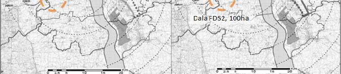
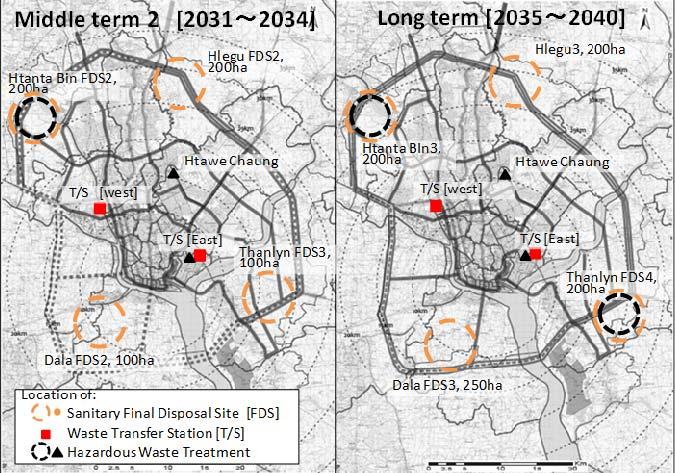
119 Figure 5.9: Infrastructure Layout Plan (Solid Waste Management) 106
120 (3) Implementation Schedule The Project for the Strategic Urban Development Plan of the Greater Yangon The procurement of equipment for improvement of waste collection and transportation capacity is urgently required. In short term, sanitary landfill projects, which are indispensable to secure sanitary waste stream, and development of hazardous waste treatment facilities necessary for increasing amount of such waste from industrial sector such as Thilawa SEZ would be necessary in addition to the continuous capacity development of operational aspects such as landfill operation, waste collection system and preparation of action plans. In middle and long terms, renewal and increase of equipment and facilities should be repeated at relatively short span to correspond to the exploding waste amount in future. No. Project for Supply of Collection 1 Equipment for Solid Waste Management (1) Project for Capacity 2 Development of SWM (1) Project for Sanitary Landfill 3 Development [Htein Bin] Project for Hazardous Waste 4 Treatment Facility (Pilot scale) [Htawe Chaung] Project for Sanitary Landfill 5 Development [Kyi Su] Project for Sanitary Landfill 6 Development [Hlaing Tharyar] Project for Sanitary Landfill 7 Development [Thanlyn(1)] Project for Sanitary Landfill 8 Development [Dala(1)] Project for Capacity 9 Development of SWM (2) Project for Supply of Collection 10 Equipment for Solid Waste Management (2) Project for Transfer Station (TS) 11 Development [Eastern site] Project for Transfer Station (TS) 12 Development [Western site] 13 Project for Hazardous Waste Treatment Facility [Eastern site] 14 Project for Sanitary Landfill Development [Htanta Bin(1)] Project for Sanitary Landfill Development [Hlegu(1)] Project for Sanitary Landfill Development [Thanlyn(2)] Project for Sanitary Landfill Development [Dala(2)] Project for Sanitary Landfill Development [Htanta Bin(2)] Project for Sanitary Landfill Development [Hlegu(2)] Project for Sanitary Landfill Development [Thanlyn(3)] Table 5.25: Implementation Schedule (Solid Waste Management) Urgent Project Name Project for Sanitary Landfill Development [Hlegu(3)] Project for Sanitary Landfill Development [Thanlyn(4)] Project for Sanitary Landfill Development [Dala(3)] Project for Hazardous Waste Treatment Facility [Thanlyn] Implementation Schadule Status Shortterm Shortterm Shortterm Shortterm Shortterm Shortterm Shortterm Shortterm Middleterm Middleterm Middleterm Middleterm Middleterm Middleterm Middleterm Middleterm Middleterm Middleterm Middleterm Project for Supply of Collection Longterm Equipment for Solid Waste Management (3) 22 Project for Supply of Collection Longterm Equipment for Solid Waste Management (4) 23 Project for Expansion of Transfer Longterm Station (TS) [Eastern site] 24 Project for Expansion of Transfer Longterm Station (TS) [Western site] 25 Project for Sanitary Landfill Longterm Development [Htanta Bin(3)] Longterm Longterm Longterm Longterm < Legend > : Feasibility Study : Detailed Design, Tender Preparation, Tendering : Construction : Commencement of Operation : Capacity Development 107
121 5.9 Information Telecommunications Demand Analysis (1) Fixed Telephones In 2009, the number of fixed telephone subscribers in Myanmar was 1,077,084, of which 499,914 were in Yangon City. The telephone penetration rates in Myanmar and Yangon City were 2% and 10%, respectively. In the near future, Myanmar s GDP and Yangon City s GRDP will grow rapidly and with it, the fixed telephone penetration rate will match those of other Asian countries. Therefore, the forecast formula of penetration ratio is calculated with reference to the penetration ratios of neighboring countries such as Thailand, Laos, Malaysia, Cambodia and Vietnam. The estimated number of fixed telephones is shown in Table Table 5.26: Estimated Number of Fixed Telephones (Number of subscribers) Yangon GRDP/Capita (US$) 2,437 3,368 4, Penetration Ratio(%) a Yangon Population b 5,698,130 6,154,240 6,478,420 7,365,563 9,520,934 10,824,712 No of Fixed Telephone c = a x b 487, , ,104 1,023,762 1,598,655 1,877,012 Adjusted No of Fixed Telephone 787, ,912 1,057,104 1,323,762 1,898,655 2,177,012 d=c+300,000 (2) Mobile Phones The number of mobile phones in Myanmar was 579,909 in 2009, of which 297,040 were in Yangon. The penetration ratio was 1.2% and 4.3%, respectively. The number of mobile phones is estimated with the same method used for fixed telephones. The result of the demand forecast is shown in Table Table 5.27: Estimated Number of Mobile Phones (Number of terminal units) Items Yangon GRDP/Capita (US$) 2,437 3,368 4, Penetration Ratio(%) a Yangon Population b 5,698,130 6,154,240 6,478,420 7,365,563 9,520,934 10,824,712 No of Mobile phone c = a x b 4,474,402 5,322,672 5,912,508 7,384,785 10,665,104 12,367,226 Adjusted No of Mobile phone 2,024,402 2,872,672 3,462,508 4,934,785 8,215,104 9, d=c-2,450,
122 5.9.2 Development Policy Objectives Basic Policy Creation of Advanced Information and Communication Society 1) High Speed & High Reliance Telecom Network 2) Offer of Various Services 3) Convenience of Telecommunications 4) Introduction of Advanced Technologies Development Goals and Target Effect Indicators Table 5.28: Development Goals and Target Effect Indicators (Telecommunication) Development Goal Effect Indicators Construction of Next Generation Network Penetration Ratio = 16% User Satisfaction Preliminary Development Plan for Telecommunication The preliminary development plan in the telecommunication sector can be categorized in terms of the following key items. Modernizing the fixed telephone network (NGN: Next Generation Network) Expanding the international lines Upgrading Yangon City s metro network Expanding the intercity backbone and core network connecting major cities Enhancing network security, migrating to IPv6, etc. From among the items above, the preliminary development plan focuses on NGN implementation in Yangon in consideration of the scope of other on-going projects, etc. (1) Preliminary Development Plan The old transmission facilities are only used for telephone communications. The OFC lines will be used for telephones as well as for high speed data transmissions, internet, various new services and as a mobile phone backbone. OFC (FTTB) will be connected to universities, major hospitals and shopping centers to facilitate internet communications and high speed data transmissions. Township and ward offices need to be connected with high speed telecommunications facilities to promote e-government. For the results to show early on, FWA (Fixed Wireless Access) and LTE (Long Term Evolution) should be deployed in addition to the optic fibers when linking subscribers as last one mile connection. NGN will be constructed in all districts of Yangon City. (2) Infrastructure Layout NGN will be constructed in all districts of Yangon based on the demand forecast. As a first step, the NGN core facilities will be constructed in central Yangon, Pabeden, Hanthawaddy, Tamwe, and Mayangon. Hanthawaddy has a national gateway, while Mayangon has an international gateway. The 109

123 number of subscribers will be 300,000 based on the demand forecast. Next, NGN core facilities will be constructed in the suburbs, such as Thanlyin and Dagon Myothit with a target of 300,000 subscribers. Finally, as a third step, the core facilities will be constructed in Hlaing Tharyar for 300,000 subscribers. The NGN core facilities location is shown in Figure FY Hanthawaddy 2. Mayangon 3. Tamwe FY Pabedan FY Thanlyin 6. Dagon Myothit 7. Hlaing Tharyar Figure 5.10: Proposed Layout of NGN Core Facilities (3) Implementation Schedule No. Project Name Status Table 5.29: Implementation Schedule (Telecommunication) Implementation Schadule (FY) NGN (Hanthawaddy, Myangon, Tamwe, Pabedan) NGN (Thanlyin, Dagon Myothit) Short-term Middleterm < Legend > : Feasibility Study : Detailed Design, Tender Preparation, Tendering : Construction : Commencement of Operation 3 NGN (Haing Tharyar) Long-term 110
124 CHAPTER 6: URBAN DEVELOPMENT AND MANAGEMENT PROGRAMS 6.1 Capacity Development Plan Issues of Administrative Works for Urban Planning and Development A capacity development plan is formulated corresponding to categories of works, which relate for urban planning and development by administrative organizations from planning until construction. 1) Coordination: to identify relevant stakeholders and to share future development visions, to set the roles and responsibilities of every relevant organization. 2) Survey, research: to grasp current spatial situation, to collect and to revise information 3) Planning: to study, to make and to authorize the plan among relevant organizations 4) Establishing legal system: to establish legal systems, such as laws, regulations or bylaws; to formulate plans into legal regulations 5) Controlling: to establish spatial control system and to provide permission for building construction and town/ district development 6) Realizing: to guide the project for public profit with assistance for realization Existing future vision of role sharing between administrative organizations In this vision, the main roles of the Union government will be policy making for national level development, formulation of legal matters, and planning of regional development matters. Involvement of the regional government is expected for urban planning matters within the region and its operation. It means that urban planning would be handled by the regional government in the future. Implementation of individual urban planning projects is expected to be executed by the local administrative organizations (district, township or city = YCDC). 111
125 Proposed National Level Regional Development Planning System Regulatory Proposed Policy and Directions Appointing Urban System Urban Development Housing Development Union Level National Laws Legislating, Authority Appointing & Supervising Laws framing for National Regions Development National Housing Development Laws Myanmar Building Codes Condominium Laws National Regional Development Drafting, Authority Appointing & Supervising National Urban Network Project National Multi Land Use Project National Projects of Sustatinable Minerals Utilizing Coordination Regulatory + Operation Inspecting, approving and supervising Basic Policies, objectives of policies or directions for regional development Projects by sectors States or Regions Level Proposing of Divisions or States policies and objectives in accordance with National Urban & Housing Policies Issuing development procedures and regulations for the Division or State Developments Issuing urban and infrastructues procedures and regulations for the Division or State Developments Drafting of Divisions or States Regional Development Projects and implementing Coordination OOperation Basic Policies, objectives Status of land use planning, urban development procedures Procedure and regulations housing development procedures. Township or City Coordination Level Source: Ministry of Construction, DHSHD Implementing consideration and objectives for a township or land uses Repairing and Implementing of stable land use plans like laws and regulations Implementing of Urban Development Procedures Implementing of Housing Development Procedures s Coordination Figure 6.1: Future Vision of Role Sharing between Administrative Organizations Related issues of administrative organizations (1) Personal assignment At present, the number of urban planning experts and engineers are quite limited. And thus, it seems difficult to carry out all the expected roles which are related to urban planning and development issues. Yangon Technological University restarted to offer urban planning course since 2012 for postgraduates. Following are the current situation of personnel assignments in relevant organizations: 1) Union Ministry (Ministry of Construction) About 20 engineers/planners are assigned in DHSHD and work for regional planning and urban planning matters. They cover the whole Myanmar therefore, it is difficult to conduct planning and its implementation in detail level. 2) Regional government (Yangon regional government) The Union Ministry of Construction has an office in the regional government and has one assigned staff. It seems difficult to satisfy all the expected roles regarding urban planning matters. 112
126 3) District office The number of persons in charge in urban planning matters is limited (one person in most cases). And their education, professional experience, and knowledge about urban planning are limited. 4) Township office (under the Ministry of Home Affairs) Same as the district office, the number of persons in charge for urban planning matters is limited (one person in most cases). Furthermore, their education, professional experience, and knowledge about urban planning are limited. 5) YCDC (Urban Planning Division) About 50 engineers are assigned in the Urban Planning Division. But their professional experience about urban planning is short and limited. Therefore, technical training is necessary for them. (2) Allocation of budget Formerly, budget for the implementation of public-oriented urban development projects were decided and allocated by the Union ministries. Currently, DHSHD does not have any budget for the implementation of urban development. And the Department of Public Works of the Ministry of Construction has a budget mainly intended to be used for maintenance. The Union government is planning to delegate gradually the budget planning power to the regional government. In this context, it is necessary to arrange adequate staff for project planning and implementation for local administrative organization. Also, their capacity development program concerning this professional field needs to be considered. (3) System of government At present, YCDC is assigning more staff in the urban planning division than in other administrative organizations. But the authority and power of YCDC on urban planning/ development matters are not clearly defined, and the conventionally assigned tasks under the current system are quite limited. On the other hand, few staff is assigned in the local government organizations, which have authority and power in urban planning matters, such as the regional government, district offices, and township offices. Considering the above mentioned situation, it is realistic to assume that YCDC functions as supporting agency for urban planning and its implementation. For the assumed future role sharing among relevant administrative organizations, it is necessary to consider these possibilities of cooperation between different organizations Future Expected Administrative Roles for Urban Planning and Development and Prospect Current problems corresponding to categories of administrative works for urban planning and development will be identified at first. For its formulation, following matters ware taken in to consideration. Current administrative works, which are executed by each administrative organization (shown in small characters in the Table 6.1). Future vision of role sharing between administrative organizations (ref (2)) Current situation of personal assignment for relevant organizations 113
127 Allocation of budget System of government The Project for the Strategic Urban Development Plan of the Greater Yangon Then expected responsible organization and its countermeasure will be proposed as Table 6.1. (1) Coordination: Union ministry and regional government are expected to take an initiative to coordinate relevant local administrative offices in order to discuss and to make a decision for inter-district and inter-township matters. For local administrative offices (district, township and YCDC), strengthening of coordinating function with private developers and residents are necessary. (2) Survey and research: Union ministry is expected to take an initiative on formulation of necessary information items, data format and procedures with consideration its application to the whole country. Urban planning division of YCDC is expected to extend their functions for data collection and data entry and to take roles on updating and provision of necessary information to other relevant organizations. (3) Planning: Region government, district offices and township offices are expected to continue their PIC relating activities (grasping urban situation and problems, making projects program, and monitoring). YCDC roles will be Updating Urban Development Master Plan, giving technical advices on planning of region, district and township, and offering consultancy service for formulating development plan (4) Establishing legal system: Union ministry (Ministry of Construction) can promote preparation and legalization of necessary law and regulation. Also, authorization of relating plans and drawings are considered under responsibility of union ministry and region government. On the other hand, YCDC is considered as a candidate organization, which prepares draft plan and relating regulations with relating basic studies. (5) Controlling: Control system on urban and district development is considered to be established according to the progress of legalization of relating laws and regulation. Authorization of development project will be done under the responsibility of union ministry and region government based on these legal frameworks. YCDC is considered as a candidate organization, which carries out technical examination service and provides consultancy services. District offices and township offices are expected to develop a consensus of neighboring residents and to give suggestion on the proposed project. (6) Realizing: Establishing specific project scheme and budget preparation is considered roles of union ministry and regional government. Role of coordination of relevant stakeholders (developers, residents, and other administrative organization) for the project is supposed to be taken by local administrative organizations (district office, township office). 114
128 Table 6.1: Administrative Works for Urban Planning and Development (Current Situation) Categories of Organizations Administrative works for Urban Planning Union Ministry Regional Ministry District Township YCDC 1. - Coordination with - Coordination with - Discussion - Discussion - Discussion with Coordinatio other relevant union other relevant with relevant with relevant private developers n ministries regional ministries departments departments about effective use of - Evaluate proposed - Coordination of for the for the city-owned land subprojects from PIC necessary implementati implementati (Deparment of - Necessary budget discussion with on of PIC on of PIC Engineering, building) allocation for public relevant union - Consultation - Consultation - Assistance for oriented projects ministries - Coordination with with regional government between private coordination between different stakeholders districts for - Coordination developers - Assistance for inter-regional with districts with public discussion between planning matters for institutions residents and inter-townshi - Public administrative p planning consultations organizations matters 2. Survey - Formulation of - Data collection - Possessing - Possessing - Collecting basic and necessary about examples on basic social basic social survey on urban Research survey/research items land transactions information information planning related to be requested from - Data collection (ex. (ex. matters (ex. survey on regional/state about urban population) population) traffic volume, government and local planning related - Possessing - Possessing commercial shop list) administrative office matters information information - Collecting additional - Formulation of on related on related urban planning related survey/ research data public public information (ex. format facilities facilities building use, land use) - Data management about urban planning information with its updated works 3. Planning - National land use - To formulate the - To formulate - To formulate - Updating the Urban planning in regional implementation the the Development Master planning level plan of implementati implementati Plan subprojects on plan of on plan of - Giving technical according to PIC subprojects subprojects advices on regional, - To formulate according to according to district, and township related sector plans PIC PIC planning (ex. Transport - Consultancy services planning) for formulating public/ administrative oriented development plans 4. Establishing a Legal System - Formulating the Myanmar National Building Code - Preparing laws/ regulations on urban planning matters - Preparing laws/ regulations on large scale development matters - Preparing planning/ application manual for urban planning/ development matters - Formulating detailed - Formulating detailed spatial plan for control on land use and development capacity - Legalization of spatial control and technical requirements into bylaws, regional regulation and/or guidance according to the detailed spatial plan (land Formulating detailed spatial plan for control on land use and development capacity - Formulating detailed spatial plan for control on land use and development capacity - Giving technical advices in the formulation of bylaws, regulations, standards and requirements - Consultancy services in formulating detailed spatial plans
129 Categories of Administrative works for Urban Planning 5. Controlling 6. Realization The Project for the Strategic Urban Development Plan of the Greater Yangon Organizations Union Ministry Regional Ministry District Township YCDC technical requirement for development/construct ion matters - Assessing and providing development permits for special development areas use control, development permits, district planning, etc.) - Formulating technical standard to be applied for development and construction - Assessing and providing development permits for large scale development. - To authorize the district plan, which are formulated by residents, private organizations and/or public initiatives - Necessary budget - Necessary budget allocation for allocation for public-oriented projects public-oriented projects - Giving suggestions and advices in the formulation of development permits and district plans - Advancement of development/ spatial improvement projects by assistance and coordination with administrative offices - Provide recommendat ion letter for building construction (Chief ward) - Giving of suggestions and advices in the formulation of development permits and district plans - Advancement of development/ spatial improvement projects by assistance and coordination with administrativ e offices - Examination of application document for building construction (including structural examination on large scale building construction) - Giving technical advices in the formulation of district plans and its regulations - Consultancy services for assessing development permits - Consultancy services for landscape, townscape, and urban space design control - Consultancy services for public spatial design control and its management - Advancement of development/spatial improvement projects in city-owned land - Supporting public-oriented development/spatial improvement projects by public financial assistance and micro finance 116
130 6.1.5 Formulation of Capacity Development Plan Corresponding to the subjects in Section 6.1.1, the necessary capacity development program and technical assistance program were assumed as shown in Figure 6.2. Counterpart organizations are described based on supposition. Therefore, it is necessary to re-evaluate their appropriateness according to the situation and prospect of role sharing at each point of time in the execution of the programs. Also, time framework is set according to sequential order between related subprojects. Time period can be adjusted according to the progress of each subproject. Categories of works Table 6.2: Expected sub programs for capacity development and technical assistance Purpose of Capacity building Activity Supposed Counterpart - Establish collaborating relationship between Union/ Region/ Local Government and administrative organizations 1. Coordination - Exchange of views on urban planning matters in region ministers - Exchange of views on urban planning matters between engineers 2. Survey, research 3. Planning 1a. Assitance for publicity of master plan and result of PIC 1b. Planning coordination and discussion about above mentioned plans and its implementation 1c. Assistance for sharing about technical TS knowledge for urban planning / YCDC 2a. Assistance for formulation of information list, data collection mannual and its format 2b. Assistnace for execution of data collection 2c. Assistance of DATA management (GIS) 3a. Assistance for formulation of planning items to be drawn in the plan 3b. Assistance for formulation of detailed spatial plan for control Project period (draft) Union (MoC, Min of National Planning & 2013:Trial execution Economic Development) 2013:Preparatory Region (Office of MoC) coordination District, Township Union/ Region/ District/ TS / YCDC (2013:Trial Union/ Region/ District/ execution as pilot project(*1)) Union (MoC, MoNPED and other relating infrastructure ministries) District/ TS/ YCDC Region/ YCDC (District/ TS) District/ YCDC TS/ YCDC (Region/ District) 3c. Assistance for integration of detail Region/ District/ TS plan according to PIC and development (YCDC) 4a. Assistance for assesment on Union (MoC)/ Region application of introduction of new control (District/ TS) measures 4b. Establish strategy for introduction of spatial control measures 4c. Assistance for formulation of study on urban planning law, standard and regulation landuse control measures 4. Establishing le- Establishment of permission for large scale development 4d. Assistance for formulation of its - Establishment of relative application manual and information sharing legal system (district planning, for regional/ local urban planning agency urban redevelopment etc.) 5. Controlling - Formuation of information list of survey for urban planning - Execution of preliminary survey - Formalization of legal procedure for urban planning procedures - Formalization of integration of planned matters into urban planning drawing - Formalization of detail planning for control - Establishment of relative laws, regulations and requirements to be applied as - Establishment of consultation and permission system for development - personnal arrangement and capacity development for the task 4e. Assistance for study on contents to be included in bylaw, regulation and requirements 5a. Trial application of control measures for pilot projects or pilot area (ex. ward) 5b. Technical assistance for training on application of control measures and evaluation on development plans (2013:Trial execution(*2)) (2013:Trial execution(*2)) (2013:Trial execution(*2)) 2014 Union (MoC)/ Region 2014 Union (MoC) Union (MoC)/ (Region) Region District/ TS/ YCDC (Region) District/ TS/ YCDC (Region) :Trial execution(*4) Remarks *1: Technical transfer is possible, but relating agencies are not officially allocated as C/P *2: Draft proposal for pilot study area will be shown *2: Draft proposal for pilot study area will be shown *2: Draft proposal for pilot study area will be shown *3: MoC prepares as their own activity *4: Draft proposal will be prepared. It will not mean getting full agreement by relating administrative organizations 6. Realizing - Capacity development for public consultation, coordination with residents and private sector - Capacity development for project implementation - Capacity development for project management 6a. Study and assistance for possible YCDC (Dept of building) acceleration measures for implementation District/ TS of urban development projects 6a. Study and assistance for possible acceleration measures for community based urban spatial improvement District/ TS a. Study and assistance for possible acceleration measures for public oriented Region project 117
131 6.2 Priority Programs The Project for the Strategic Urban Development Plan of the Greater Yangon Priority Programs To achieve the development visions Yangon 2040 and the sustainable urban development, in total 13 sub-programs, in both urban development sector and urban infrastructure development sector, were identified in this study. Under these sub-programs, in total 26 in urban development sector and 51 in urban infrastructure development sector, were identified for implementation purpose. Table 6.3: Priority Program of Urban Development and Management (List of Projects) Field Project Name Project Outline UD-01 - To share some functional activities (business, commercial and Mindama Secondary Administrative) to Mindama secondary CBD CBD Development - To control the road traffic congestion in the CBD Project - To accumulate foreign direct investments to Mindama secondary CBD Urban Development and Management (UD) UD-02 Thilawa SEZ Class-A Area Development Project UD-03 Bago Riverside Sub-center Development Project UD-04 Dagon Myothit Sub-center Development Project UD-05 Public Facilities and Buildings in CBD Transfer and Renovation Project UD-06 Formulation of CBD Renewal Scheme Project UD-07 Prioritized CBD Renewal and Redevelopment Project UD-08 A Survey and Utilization Plan for Unused Lands Project UD-09 Prioritized Unused Lands Development Project UD-10 Statistics System Elaboration Project - To promote various economic activities such as manufacturing, logistics, commerce, services, etc. - To accumulate foreign direct investments (FDIs) - To establish forward and backward linkages between FDI providers and local business societies. - To engage local business societies in non-traditional industries. - To establish an integrated and efficient logistics services in order to contribute to the regional and global supply chain. - To contribute in Thilawa SEZ development to achieve rapid economic growth - To create job opportunities for local workers. - To build a good residential area in the suburbs of Yangon City - To form a new district that has easy access to railway - To provide high-rise residential buildings adjacent to the river - To build a pleasant residential area in the suburbs of Yangon City - To build a new district that has easy access to railway - To promote the relocation of government offices to secondary CBD, sub-centers, or suburbs - To vitalize CBD by converting the vacant sites or buildings into new facilities and functions giving more attractions and highlights - To contribute in the renovation of building to boost economic growth - To create job opportunities for local people. - Rapid reconstruction of old buildings in the CBD Offer of information to construction firm about the wish of land and floor right owners to reconstruct the buildings. - Clarify the risk in case of earthquakes in the CBD - Implementation of redevelopment projects was carried out in cooperation with the government (YCDC) and the private company - The government will prepare small green areas in the CBD - To make new functional areas (trade center, convention center, etc) with reconstruction of building - Utilization of unused land in inner area and in the CBD of Yangon City - Control the development of new residential area in the suburbs - Utilization of unused land in inner area and in the CBD of Yangon City - Control the development of new residential area to the suburbs - Training of ward officers to become a statistic expert - Unification of statistic forms 118
132 Social Service (US) Landscape and Urban Heritage (UL) UD-11 Household Database Management System Development Project US-01 Barrier-free Persons disabilities Project for with (PwDs) US-02 Education System Strengthening Project US-03 Urban Poor Assistance Project UL-01 Establishment of the Guideline and Promotion of the Management for Heritage Conservation Project UL-02 Yangon Tourism Action Plan Project - Preparation of statistic manual - Computerization of statistic reports - Submission of a periodic report to Township Office - Appropriate aggregate calculation by Township Office and YCDC - Establishment of household database which includes people s opinion acquired from workshops and sampling surveys - Conduct of periodic sample surveys - Updating and analysis of changes - Utilization of the results to urban planning - Survey on current mobility and accessibility of the PwDs in public facilities and transport modes - Establishment of laws and regulations to create barrier-free environment - Subsidy for construction/renovation of public facilities buildings and replacement of transport mode which applies to the regulations - Special assistance for children with disabilities to study in general schools by physically and educationally - Fostering of social acceptability to PwDs and minorities by public campaign - Provision of medical care services & financial aids for assistive devices - Implementation of livelihood program - Establish sign language-supported media - Support to involve in social activities eg. water festival, and disability-related sport activities - Preparation of school allocation plan according to estimated future population and number of students - Upgrading teacher quality with pre-service and in-service teacher training programs - Improvement of educational infrastructures such as open more schools with modern teaching aids - Expansion for provision of post-primary schools including middle schools and branch schools - Operation of school bus service to commute from remote area - Launching mobile school program in remote area & special program for over-age children - Upgrading education standard to international level and alignment with the needs of technology driven labor market - Close coordination with monastic schools and government to have consistency with national education policy - Develop regulations that lead to greater complementarities between private and public schools - Survey on existing living condition, education and health status of poverty group - Provision of affordable housing for low income group - Promotion of human development programs - Supporting home-based income-generating activities - Implementation of micro-finance scheme - Launching education-related assistance program such as scholarship program, school book loan program - Support system to connect the urban services - To record architectural heritage through text, photos, drawings, etc. - To assess the actual conditions of the heritage buildings and prepare drawings. - To establish a basic database of the heritage buildings and urban district, based on the collected information. - To formulate a guideline for the conservation of heritage buildings. - To establish a system based on the guidelines to be formulated. - To conduct a capacity development for officers who formulate the guideline. - To identify potential tourism resources to create an international tourism destination and gateway - To conduct a tourism baseline survey 119
133 Public Parks and Greenery (UP) Capacity Development (UC) UL-03 Tourism and Heritage Promotion Area/Street Development Project UL-04 Holding Technical Workshop for the Conservation Management and Construction Technique Project UL-05 Establishment of the Mechanism for the Realization of Heritage Buildings Project UP-01 Formulation for Guideline and Standard for Construction of New Public Parks Project UP-02 New Public Parks Construction in New Towns Project UC-01 Preparation of Manual for Urban Planning and Implementation UC-02 Urban Spatial Control Management UC-03 Formulation of Detailed Spatial Plan - To formulate a tourism development vision and strategies - To promote a community-based tourism product development - To formulate an heritage tourism action plan including institution/organization, marketing/promoting, event program, etc. - To formulate action programs including conducting a pilot project - To select an area/street to develop a community-based tourism as a model case. - To identify stakeholders and key players to conduct the pilot project - To improve sidewalks and perform road beautification by placing street furniture and trees - To create heritage tourism promotion materials (brochure, guide map, website, tourist guide/info signboard, etc.) - To organize familiarization tours, promotion events, and beautification campaigns - To control car entry and car parking in the area/street - To promote and control building façade and design - To conduct a capacity development for planners such as urban planner, architect, etc., who manage the conservation project. - To conduct a capacity development for construction technicians such as carpenters, painters, plasterer, bricklayer, etc., who perform conservation works on site. - To establish the mechanism based on the guideline to be formulated. - To conduct a capacity development for the officers who give permissions to conservation buildings. - To formulate a guideline and standard for construction of new public parks - To establish the system based on the guideline and standard to be formulated - To conduct a capacity development for officers who check and give direction to new development activities - To conduct a survey and feasibility study of a suitable site for new public parks in new towns to be developed - To conduct land reclamation by making a pond to provide soils - To harmonize the development with the natural environment - To develop basic infrastructures, and to construct pedestrians path and wood deck - To provide park equipment (playground equipment, benches, small arbors, toilets, lightings, signboards, etc.) - To plant large trees to make shade spaces in the parks - To conduct a capacity development for management of public parks - To formulate a manual for urban planning - To execute training of trainers in order to accelerate technical transfer to Myanmar engineers - Assistance in the formulation of a study on urban planning related to laws, standards, and regulations - Assistance in the study regarding the contents to be included in the by-laws, regulations, and requirements - Assistance in the formulation of the application manual and information sharing for regional/local urban planning agency - Trial application of control measures for pilot projects or pilot area (e.g., ward) - Technical assistance in the training on application of control measures and evaluation on development plans - Assistance in the sharing of technical knowledge on urban planning - Assistance in the formulation of planning items to be drawn in the plan - Assistance in the formulation of a detailed spatial plan for control measures 120
134 UC-04 Establishment of Information Management System for Urban Planning UC-05 Assistance for Possible Acceleration Measures for Urban Planning Project - Assistance in the integration of a detailed plan according to PIC and development strategy of different administrative organizations - Assistance in the formulation of information list, data collection manual, and format - Assistance in the establishment of role sharing about information management, maintenance, and practical uses - Assistance in the execution of data collection - Assistance in the DATA management (GIS) - Training on information management and maintenance - Study and assist for possible acceleration measures in the implementation of urban development projects - Study and assist for possible acceleration measures in the community-based urban spatial improvement - Study and assist for possible acceleration measures in public oriented project Urban Transportation (IT) Table 6.4: Priority Program of Urban Infrastructure Development (List of Projects) Project Name Project Outline - Restructuring the passenger bus network - Introduction of functional network system including bus zone - Reorganization of bus operation companies IT-01 Restructuring of Passenger Bus Network IT-02 Modernization of the Passenger Bus Services IT-03 Prioritization of Passenger Bus Transportation IT-04 Development of Bus Interchanges IT-05 Development of Bus Terminals IT-06 BRT System Development IT-07 Development of Public Transportation System in the CBD IT-08 Traffic Congestion Mitigation Project IT-09 Intersection Grade-separation Project IT-10 Modernization of Traffic Control and Management System IT-11 Improvement of Traffic Safety Facility IT-12 Improvement of Pedestrian Environment in the CBD IT-13 Traffic Safety Education and Propaganda IT-14 - Renewal of bus fleets - Provision of information to the passengers and introduction of smart card - Operation management by GPS and traffic safety management - Introduction of bus lane - Introduction of bus priority traffic light - Connecting point of major bus routes - Construction of facility for transfer passengers - Construction of bus terminals for each urban area - Introduction of bus rapid transit (BRT) system in the north-south urban development corridor - Circular bus or LRT in the CBD - Traffic restriction of private vehicles - Improvement of existing traffic bottlenecks - Installation of traffic signal and improvement of geometric intersection - The intersections of main roads that experience traffic congestion. - Introduction of an Area Traffic Control System, provision of information about traffic conditions - Provision of center barrier on the main roads - Construction of pedestrian bridges - Traffic enforcement, installation of traffic lights - Enforcement of law regading street vending and provide barrier-free pedestrian facilities - Development of pedestrian mall (shopping arcade) - Education and propaganda on traffic safety - Capacity development of traffic safety committee - Provision of enforcement equipment including cameras 121
135 Road Network (IR) Railway (IRW) Project Name Enhancement of Traffic Enforcement IT-15 Development of Traffic Accident Database and Traffic Safety Audit System IT-16 Computerization of Vehicle and License Registration IT-17 Transport Demand Control in the CBD IT-18 Development of Public Parking and Guidance System in the CBD IT-19 Reform of Law and Regulation on Traffic Management and Transport Demand Management IT-20 Yangon Urban Traffic Planning Unit IT-21 PTA (Public Transport Authority) IR-01 Improvement of Signalized Intersections IR-02 Construction of Flyovers/Underpasses for Bottleneck Intersections IR-03 Re-construction of Old Bridge (i.e.thaketa Bridge) IR-04 Improvement of Road No.2 IR-05 [Outer Ring Road (Section-1)] Upgrading of Road No.7 IRW-01 Automatic Level Crossing Installation in Yangon Circular Railway IRW-02 Bottleneck Elimination of Yangon Circular Railway between Yangon Central Station and Pazundaung Station IRW-03 Project Outline - Reform the laws and regulation on road traffic - Simplification of traffic violation ticket - Development of a database for traffic accident - Development of a Traffic Safety Audit System - Computerization of vehicle registration and driver s license - Pricing and registration control, etc. - Control of motorcycle use - Effective use of government vacant lands - Construction of multi-storey parking - Parking information system and enforcement - Traffic impact assessment - Garage Law, compulsory parking facilities - Laws and regulations on traffic management - Planning and monitoring of urban transport system - Updating of urban transportation database - Management of public transportation system - Policy development for public transport system - To improve the road shape of intersections with minimal land acquisition - Installation of the advanced signal control system such as ATCS (Area Traffic Control System) - Installation of preliminary traffic control center - To construct flyovers/underpasses - Provision of pedestrian facilities - To construct the new bridge by dismantling the old bridge - Widening or construction of new approach roads - Installation of proper pedestrian facility to enhance pedestrian movement across the creek - Upgrading the total 6-lane highway (20 km stretch) - Proper pavement structure for heavy vehicle - Connection to the proposed Outer Ring Road (Road No.7) - Upgrading the total 4-lane highway (26 km stretch) - To secure ROW for future Outer Ring Road - Proper pavement structure for heavy vehicle - Connection to Road No.1 and Road No.2 - To introduce automatic level crossing which open and close barrier works automatically at all existing level crossings. - To install an additional track, converting all sections to double-double track (eliminating three-track sections.). - To change the role of platforms for Yangon Circular trains and Yangon-Mandalay long distance trains. Then, an escalator and elevator should be installed for both platforms because passengers for Yangon-Mandalay long distance train, which carry large baggage are forced to use the platform located far from the concourse and connected by FOB with stairway. - To install radio-typed train detection system that is free from 122
136 Port and Logistics (IP) Water Supply (IW) Project Name Urgent Installation of Radio-typed Train Detection System in Yangon Circular Railway IRW-04 Installation of Radio-typed Telecommunication System for Yangon Circular Line (Malwagone- Yangon- Danyingone Section) IRW-05 Yangon Circular Railway Modernization (Improvement and Electrification) Phase1: Western Half Loop IP-01 Twante Canal Rehabilitation Project IP-02 Waterfront Development IP-03 Yangon Main Port Expansion IP-04 Installation of Safety Navigation Facilities (VTMS, AIS) & Navigation Aid IP-05 Thilawa Area Port Project Phase I IP-06 Replacement of Dala Ferry Ships IW-01 Renewal of Pump Station of Nyaunghnapin WTP IW-02 Renewal of Distribution Pipeline in Yankin Township IW-03 Construction of Kokkowa WTP and transfer/distribution pipeline IW-04 Construction of Lagunpyin WTP and transfer/distribution pipeline IW-05 Renewal of Distribution Pipe Network of Zone 1 IW-06 Installation of Disinfection Project Outline water-soaked track. - The radio-typed train detection system should have future expandability in order to realize moving block typed train control system in the future by adding optional devices/equipment. - To install radio-typed telecommunication system. - The western half of Yangon Circular Railway (Yangon Central Station Insein Station Danyingone Station with 21 km length) which passes through high population density areas is categorized as future main transport axis linking the north with the south in the city center. The modernization and electrification should be conducted. - In addition, to develop station plazas at the main stations in order to connect the railway with other feeder services like bus, etc. To construct robust embankment To construct commercial facilities behind Lanmadaw area (inland waterway terminal) To renovate the Pansodan-Dala Ferry terminal area at the Yangon side into modern terminal and commercial zone. To extend the Botathaung jetty terminals and construct commercial and recreation area To renovate the Sule Terminals 1, 2, 3, and 4 (by MPA s BOT scheme) To expand the MIP berthing area To install equipment, and train to facilitate operation. To construct 400 m length berth and a yard To provide three new ferry ships - Replacement of all pump facilities, improvement of preventing water hammer, refurbishment of house and installation of monitoring equipment - Replacement of distribution pipeline between Kokkin Reservoir to Yegu Pumping Station, CIP 42, - Establishment of DMA and LMB - Intake pump facilities from Kokkowa river and conduct pipeline - New WTP (75MGD) - Transfer/distribution pipeline - New WTP (40MGD) of which water resource is Lagunpyin reservoir - Transfer/distribution pipeline (19km) - Renewal of distribution pipe network (556km) - Rehabilitation of existing reservoir (2) - Installation of DMA (30) - Installation of distribution pumps for higher area -Installation of disinfection facilities such as Gyobyu WTP(27MGD), Naungnapin WTP(90MGD), Hlawaga pumping station(68mgd), 123
137 Sewerage and Drainage (IS) Project Name Facility IS-01 Improvement of water quality of Kan Dow Gyi Lake Project Outline - Waste water collecting pipe and pumping station - Eliminating water bloom and dredging up sludge from bottom - Rain water discharge facilities (7) Solid Wast Management (ISW) Telecommunication (ITC) IS-02 Installation of Sewerage System ISW-01 Project for Supply of Collection Equipment for Solid Waste Management ISW-02 Project for Capacity Development of Solid Waste Management (1) ISW-03 Project for Capacity Development of Solid Waste Management (2) ISW-04 Project for Sanitary Landfill Development 1) Htein Bin 2)Kyi Su 3) Hlaing Tharyar 4)Thanlyin 5)Dala ISW-05 Project for Hazardous Waste Treatment Facility [Pilot scale] ITC-01 Construction of Next Generation Network - C1 zone and W1 zone are the existing sewerage area and the highest urbanized area with high population density - To replace the aged vehicle with new waste vehicle - To improve the capacity of maintenance equipment - To prepare an action plan for short term development based on the development concept prepared, which is to cover facility development plan - To review, update and modify the waste collection system - To develop operation manual of hazardous waste management including separation at source, reinforcement of the polluter pay principle and operation of its treatment facility - To prepare and execute public enhancement program. To coordinate with the concerned stakeholders including depts. Of YCDC, Ministry, NGO and private sector - To develop and execute a regular training program for SWM - To review and update the action plan developed in the capacity development project1 - To train personnel for improvement of operation of the existing final disposal sites and future sanitary landfill - To review, revise and monitor the tariff table and fee collection method of SWM fee - To coordinate and stimulate private sector for setting up of 3R policy and promoting their involvement for middle term - To construct a sanitary landfill Approximate area of the project site 1) 30 ha, 2) 100 ha, 3) 150 ha, 4) 200 ha, 5) 50 ha - To procure and install necessary equipment and facility for landfill management such as weighing scale, heavy equipment, environmental monitoring equipment, etc. [Project Scope] - To construct a incinerator for hazardous waste treatment as a pilot scale facility [treatment capacity: 100ton/day] - To procure and install necessary equipment and facility - Installation of 4 NGN core facilities and construction of FTTX 124
138 6.2.2 Economic, Environmental, and Social Considerations on the Priority Programs (1) Features of Economic Effect Economic effect can be classified into stock effect and flow effect in a broad term. The stock effect can be defined as the economic effect by the stock or accumulation of facilities such as constructed infrastructure. And the stock effect can be classified into direct effect and indirect effect. Direct effect can be defined as directly benefiting the beneficiary, while the indirect effect can be defined as multiple-effect of productivity improvement on the supply-side and consumption increase on the demand-side through the direct effect. Meanwhile, flow effect can be defined as effect into macro-economic activities, e.g., job creation, increase of income, consumption, national revenue, etc., based on investment value during construction period and at the later. The stock effect of infrastructure sector mainly consists of direct-effect and indirect-effect. For instance, the direct effect in transport sector is decrease of transport cost and time as representative examples; meanwhile, the indirect effect is difficult to calculation economic benefit, e.g., user-friendliness, locational attractiveness of production activities, creation of job opportunity, consumption rise, increase in tax revenue. etc. The flow effect as mentioned above might appear as the effects based on the actual investment amount. The investment amount will be expanded from the relative industrial sectors of the project as first ripple effect to the downstream industries in series. And then the ripple effect will expand furthermore through the expansion of consumption after increase in the wage and income in relative industries. Therefore, it may be expected to increase the effect more than investment amount due to the ripple effect as mentioned above. The sector with highest amount is the Urban Development and Management, followed by Water Supply, Urban Transport, and Railway sectors, at US$ million, US$ million, US$ million, and US$ million, respectively. (2) Necessary Environmental and Social Considerations Considering that most of the Priority Projects are categorized into the software components with having minimum environmental and social impacts, the necessary environmental and social considerations on Projects are proposed as follows. It is essential to obtain appropriate environmental approval for each individual project based on the regulations to be promulgated. Basically any serious negative environmental impacts on the proposed priority projects are not expected so far. However, it is indispensable to conduct appropriate environmental management in the construction stage. In case the projects need to obtain land, it is essential to take necessary actions including establishment of appropriate resettlement action plan (RAP) with careful consideration to project affected persons (PAPs). It is necessary to establish a basic agreement with local community for the implementation of the project through the conduct of a Stakeholders Meeting (SHM). It is necessary to confirm the existence of these buildings in advance to take necessary consideration in the project implementation stage. It is necessary to conduct a socio-economic survey depending on the necessity in consideration of livelihood restoration for those people during the implementation stage. 125
139 6.2.3 Project Implementation and Management (1) The Background of the Application of Public Private Partnership (PPP) for the Study -The Unbalance of the Demand for Infrastructure and Financial Resource of Public Body- While the investment cost for the priority projects of Master Plan (MP) build up to US$ 3,345million, the financial statement of YCDC and the Government have showed continued deficit in Thus the financial investment Gap exists between the demand for infrastructure and the financial resources of Public Body. In order to implement the priority projects suggested on MP before 2018, therefore, it should be indispensable that the Government should secure the ODA of foreign countries, the loan of multilateral financial institutions and Private finance based on the PPP (Public Private Partnership) modality. Category Nos. and Cost Table 6.5: Investment Cost of Priority Project (Source; IRP-II Chapter 4) Urban Development Sector Urban Social Service Landscape Parks Development & and Heritage and Management Greenery Capacity Development Priority Nos Cost , Categ ory Nos. and Cost Road Rail way Infrastructure Sector Port Water Waste Water Solid Waste Urban Transport Power Telecom Sum Sum Grand Total Priori Nos ty Cost , ,577.2 Unit=US million dollars (2) Laws and Regulations for the Implementation of PPP Project in Union Government For the implementation of the project of PPP modality, the ODA by foreign countries including private financial support of investment and loan. Study team has reviewed the Foreign Investment Law promulgated on 2nd of November 2012 and RR as Notification Order 11/2013 and Specified Type of Economic Activities as Notification 1/2013 have been promulgated on 31 st January The investors and lenders, who extends their services under the agreements, will consider the necessity of further revision in relation to the details of PPP modality, the process of procurement of the concessionaire, the draft of PPP agreement, incentives, the government supports, the process of disputes and the clause of termination. (3) The study for the PPP Scheme which will be Applicable to each Infrastructures 1) Classification of the Project Implementation to be Applied for the Development of Infrastructure No Modality Degree of Public participatio n 1) Public Build & Operate 2) Public Build & Private Operate Synthesis of laws % regulation 100% Existing laws 100% for construction Table 6.6: Summary of PPP Modality Degree of finance by public/private 126 Provability of private finance Provability beneficiary payment 100%/ 0% None Possible Public N.A. 100%/ α% Operating capital Beneficiary payment + Government support Main Operator Private
 BTO,BOT 0% N.A. 0%/ 100% 100% + Operating capital 7) BOT, BOO 0% Share % with Hybrid 8) Concession 100% for construction 9) Joint Shared % Venture N.")
140 w/risk 3) Public Build & Private Operate wo/eisk 100% for construction 4) Affermage 100% for construction 5) BT, BLT 0% Deferred paymen The Project for the Strategic Urban Development Plan of the Greater Yangon N.A. 100%/ α% Operating capital N.A. 100%/ α% Operating capital N.A. Deferred 100%/ 100% 100% advance for construction 6) BTO,BOT 0% N.A. 0%/ 100% 100% + Operating capital 7) BOT, BOO 0% Share % with Hybrid 8) Concession 100% for construction 9) Joint Shared % Venture N.A. 0%/100% Share % with Hybrid With reference to the published report of Resource Book on PPP Case Studies, European Commission, June 2004, the distribution of the PPP modality on each nature of infrastructures are shown on the bar graph. 100% +Operation Capital share % w/hybrid N.A. 100%/ α% Operation capital Foreign Investment Law Beneficiary payment + Government support Beneficiary payment + Government support No beneficiary payment in general Beneficiary payment + (Government support) Beneficiary payment + (Government support) Private Private Private Private Private Beneficiary payment + Private Government support Shared % Shared % Beneficiary payment JV co. Private/Public Source: European Commission Resource Book on PPP Case Study (June, 2004) Figure 6.2: Distribution of the PPP Modality 2) The Evaluation of the Project Implementation and Management Scheme which will be Applicable for Priority Project. The Evaluation of Priority Project by Categories Type-A is the indispensable project under the requirement of social and environmental views which shall be implemented by public works ignoring the financial feasibilities. Type-B is as same as Type A. However the operation will be undertaken by Private sector. (Public Build and Private operate, Affermage, Concession) Type-C is as same as Type A. However private sector will advance the whole construction cost of the project and recover it by a means of differed payment or lease payment within agreed term..(bt BLT) Type-D is the indispensable project under the requirement of social and environmental views. The hybrid PPP will be appropriate where insufficient demand or restriction on tariff rate exist.(bto BOT JV) Type-E is the indispensable project under the requirement of social and environmental views. The project is economically viable and financially feasible to enable the private sector to invest.(bot BOO) 127
Ms.Khin Aye Myint Executive Engineer Engineering Department ( Water & Sanitation ) Yangon,Myanmar OVERVIEW OF MYANMAR.
 Yangon,Myanmar OVERVIEW OF MYANMAR.") Ms.Khin Aye Myint Executive Engineer Engineering Department ( Water & Sanitation ) Yangon,Myanmar OVERVIEW OF MYANMAR Yangon 1 OVERVIEW OF YANGON CITY AREA Yangon YANGON CITY AREA : 730 Km² POPULATION
Ms.Khin Aye Myint Executive Engineer Engineering Department ( Water & Sanitation ) Yangon,Myanmar OVERVIEW OF MYANMAR Yangon 1 OVERVIEW OF YANGON CITY AREA Yangon YANGON CITY AREA : 730 Km² POPULATION
Water Supply Governance in YCDC. U Myo Thein Deputy Head (Director) of Department Engineering Department (Water & Sanitation)
 of Department Engineering Department (Water & Sanitation)") Water Supply Governance in YCDC U Myo Thein Deputy Head (Director) of Engineering (Water & Sanitation) Content Introduction to Yangon City and YCDC Future population and Water Demand Challenges and Current
Water Supply Governance in YCDC U Myo Thein Deputy Head (Director) of Engineering (Water & Sanitation) Content Introduction to Yangon City and YCDC Future population and Water Demand Challenges and Current
Ex-Ante Evaluation (for Japanese ODA Loan)
") Japanese ODA Loan Ex-Ante Evaluation (for Japanese ODA Loan) 1. Name of the Project Country: The People s Republic of Bangladesh Project: Dhaka Mass Rapid Transit Development Project (Line 5) (E/S) Loan
Japanese ODA Loan Ex-Ante Evaluation (for Japanese ODA Loan) 1. Name of the Project Country: The People s Republic of Bangladesh Project: Dhaka Mass Rapid Transit Development Project (Line 5) (E/S) Loan
Investment Opportunities in Yangon Region
 Investment Opportunities in Yangon Region Dr Marlar Myo Nyunt Dr. Marlar Myo Nyunt Deputy Director General Directorate of Investment and Company Administration Ministry of Planning and Finance Key Sectors
Investing in Sustainable cities. Water Management in urban areas: Yangon s case
 Investing in Sustainable cities Water Management in urban areas: Yangon s case I. Water management: general perspective The main goals of urban water and waste water management are : provide clean water
Ex-Ante Evaluation (for Japanese ODA Loan)
") Japanese ODA Loan Ex-Ante Evaluation (for Japanese ODA Loan) 1.Name of the Project Country: The Republic of the Union of Myanmar Project: Bago River Bridge Construction Project Loan Agreement: March 1,
Japanese ODA Loan Ex-Ante Evaluation (for Japanese ODA Loan) 1.Name of the Project Country: The Republic of the Union of Myanmar Project: Bago River Bridge Construction Project Loan Agreement: March 1,
Preparatory Survey for Regional Development for Poverty Reduction Phase II Final Report
 Republic of the Union of Myanmar Foreign Economic Relations Department, Ministry of Planning and Finance Planning Department, Ministry of Planning and Finance Department of Highways, Ministry of Construction
Disaster Reduction Programme in Myanmar
 Disaster Reduction Programme in Myanmar Dr. Toe Toe Win Associate Professor Civil Engineering Department Yangon Technological University Yangon Union of Myanmar Myanmar Overview The Union of Myanmar is
PROJECT FOR COMPREHENSIVE URBAN TRANSPORT PLAN OF THE GREATER YANGON (YUTRA) FINAL REPORT SUMMARY
 FINAL REPORT SUMMARY") PROJECT FOR COMPREHENSIVE URBAN TRANSPORT PLAN OF THE GREATER YANGON (YUTRA) FINAL REPORT SUMMARY December 2014 ALMEC Corporation Oriental Consultants Co., Ltd Nippon Koei Co., Ltd The exchange rate used
PROJECT FOR COMPREHENSIVE URBAN TRANSPORT PLAN OF THE GREATER YANGON (YUTRA) FINAL REPORT SUMMARY December 2014 ALMEC Corporation Oriental Consultants Co., Ltd Nippon Koei Co., Ltd The exchange rate used
Japanese ODA. Ex-ante Evaluation
 Japanese ODA Ex-ante Evaluation 1. Name of the Project Country: The Socialist Republic of Vietnam Project: North-South Expressway Construction Project (Da Nang Quang Ngai Section) (I) (II) (III) L/A signed
Project for the Improvement of Water Supply, Sewerage and Drainage System in Yangon City. Final Report. Volume VI
 Project for the Improvement of Water Supply, Sewerage and Drainage System in Yangon City Final Report Volume VI Sewerage and Drainage System Mater Plan Appendix Appendix Table of Contents A. WATER QUALITY
ASSESSEMENT OF GROUNDWATER VULNERABILITY IN YANGON CITY, MYANMAR
 ASSESSEMENT OF GROUNDWATER VULNERABILITY IN YANGON CITY, MYANMAR Dr. Wint Wint Htun Assistant Lecturer, Department of Geology University of Yangon 29 th January, 2015 YCDC Area Yangon Division Panhlaing
Ex-Ante Evaluation (for Japanese ODA Loan)
") Japanese ODA Loan Ex-Ante Evaluation (for Japanese ODA Loan) 1. Name of the Project Country: The People's Republic of Bangladesh Project: Dhaka Urban Transport Development Project (I) Loan Agreement: February
Japanese ODA Loan Ex-Ante Evaluation (for Japanese ODA Loan) 1. Name of the Project Country: The People's Republic of Bangladesh Project: Dhaka Urban Transport Development Project (I) Loan Agreement: February
Myanmar Land of Opportunities and Challenges
 Myanmar Land of Opportunities and Challenges 2016 What are the associations? U.S.A U.K. Aung San Suu Kyi China Myanmar 2 Where is Myanmar? Myanmar s Vital Statistics Population -Male -Female Area 53.96
SECTOR ASSESSMENT (SUMMARY): URBAN TRANSPORT 1
: URBAN TRANSPORT 1") Greater Dhaka Sustainable Urban Transport Project (RRP BAN 42169) Sector Road Map SECTOR ASSESSMENT (SUMMARY): URBAN TRANSPORT 1 1. Sector Performance, Problems, and Opportunities 1. Dhaka, the capital
Greater Dhaka Sustainable Urban Transport Project (RRP BAN 42169) Sector Road Map SECTOR ASSESSMENT (SUMMARY): URBAN TRANSPORT 1 1. Sector Performance, Problems, and Opportunities 1. Dhaka, the capital
Yangon s Master Plan: What will Yangon look like in 2030?
 «Let s draft a Green Yangon!» Participatory Conference on Yangon s Future 30th January 2015,City Hall, Yangon Yangon s Master Plan: What will Yangon look like in 2030? Dr Toe Aung Director of Urban Planning
Ex-Ante Evaluation (for Japanese ODA Loan)
") Ex-Ante Evaluation (for Japanese ODA Loan) 1. Name of the Project Country: The People s Republic of Bangladesh Project: The Kanchpur, Meghna and Gumti 2nd Bridges Construction and Existing Bridges Rehabilitation
Ex-Ante Evaluation (for Japanese ODA Loan) 1. Name of the Project Country: The People s Republic of Bangladesh Project: The Kanchpur, Meghna and Gumti 2nd Bridges Construction and Existing Bridges Rehabilitation
Japanese ODA loan. Ex-ante Evaluation
 Japanese ODA loan Ex-ante Evaluation 1.Name of the Project Country: The Socialist Republic of Vietnam Project: North-South Expressway Construction Project (Da Nang Quang Ngai Section)(I) L/A signed on:
Japanese ODA Loan. Ex-Ante Evaluation
 Japanese ODA Loan Ex-Ante Evaluation 1. Project Country: People's Republic of Bangladesh Name of the Project: Haor Flood Management and Livelihood Improvement Project Loan Agreement: June 16, 2014 Loan
'Perspectives for Adaptation and Mitigation Co-Benefits -JICA's Cooperation for Resilient and Low- Carbon Development'
 3rd Asia-Pacific Climate Change Adaptation Forum Panel 2.1 Investing in adaptation technologies with mitigation co-benefits in Incheon, Republic of Korea, 18 March, 2013 'Perspectives for Adaptation and
1) Asian Highway in Myanmar and Greater Mekong Subregion (GMS)
 Asian Highway in Myanmar and Greater Mekong Subregion (GMS)") 2.3.2 Road Network (1) Road Network in the Greater Mekong Subregion and Myanmar 1) Asian Highway in Myanmar and Greater Mekong Subregion (GMS) Greater Yangon is connected with its neighboring GMS countries
2.3.2 Road Network (1) Road Network in the Greater Mekong Subregion and Myanmar 1) Asian Highway in Myanmar and Greater Mekong Subregion (GMS) Greater Yangon is connected with its neighboring GMS countries
LOCAL AUTHORITY AND SUBPROJECT SELECTION CRITERIA
 Additional Financing of Local Government Enhancement Sector Project (RRP SRI 42759) LOCAL AUTHORITY AND SUBPROJECT SELECTION CRITERIA A. Eligible Local Authority and Subprojects 1. Unless otherwise agreed
Sustainable Urban Mobility Planning. Dr. Toe Aung Director of Urban Planning Division Yangon City Development Committee
 Sustainable Urban Mobility Planning Dr. Toe Aung Director of Urban Planning Division Yangon City Development Committee Background and Objectives Yangon City, with a population of about 5.21 million as
Summary of Environmental and Social Consideration in Development Study (Preparatory Study)
") Summary of Environmental and Social Consideration in Development Study (Preparatory Study) 1. Full title of the Project The Study on Integrated Development Strategy for Danang City and Its Neighboring
Summary of Environmental and Social Consideration in Development Study (Preparatory Study) 1. Full title of the Project The Study on Integrated Development Strategy for Danang City and Its Neighboring
Current Activities on Water Supply Management in Yangon City
 Yangon City Development Committee Engineering Department (Water & Sanitation) Current Activities on Water Supply Management in Yangon City Presented By - Ei Khaing Mon Assistant Engineer Engineering Department
PREPARATORY STUDY ON THILAWA SPECIAL ECONOMIC ZONE INFRASTRUCTURE DEVELOPMENT IN THE REPUBLIC OF THE UNION OF MYANMAR FINAL REPORT
 THE REPUBLIC OF THE UNION OF MYANMAR THILAWA SEZ MANAGEMENT COMMITTEE PREPARATORY STUDY ON THILAWA SPECIAL ECONOMIC ZONE INFRASTRUCTURE DEVELOPMENT IN THE REPUBLIC OF THE UNION OF MYANMAR FINAL REPORT
STUDY ON FINAL REPORT SUMMARY. February 2013
 STUDY ON ECONOMIC PARTNERSHIP PROJECTS IN DEVELOPING COUNTRIES IN FY2012 STUDY ON THE SECOND JAKARTA-CIKAMPEK TOLL-ROAD PROJECT IN THE REPUBLIC OF INDONESIA FINAL REPORT SUMMARY February 2013 Prepared
Drivers of Change Affecting Myanmar Forests: Towards formulation of GMS action plans
 Drivers of Change Affecting Myanmar Forests: Towards formulation of GMS action plans Maung Maung Than, Independent Consultant 1 Manila, Phillipine 26-01-2016 Outlines of Presentation I. Forest Cover Status
ENVIRONMENTAL SCOPING PLAN
 APPENDIX F ENVIRONMENTAL SCOPING PLAN F.1 DATA OF EXAMINATION Table F.1.1 Data of Examination No. Items Description 1 Full title of the Project and relevant report 2 Type of the study Development Study
Myanmar Logistics Sector Report (November 2018) MMRD Research Division 1
 MMRD Research Division 1") 1 P a g e Check the updates of s Syndicated Products at www.mmrdrs.com/syndicated-research/ Disclaimer produces syndicated products to those needs. All rights reserved. No part of these data or documents
1 P a g e Check the updates of s Syndicated Products at www.mmrdrs.com/syndicated-research/ Disclaimer produces syndicated products to those needs. All rights reserved. No part of these data or documents
LAW OF THE REPUBLIC OF INDONESIA NUMBER 7 OF 2004 REGARDING WATER RESOURCES
 LAW OF NUMBER 7 OF 2004 REGARDING WATER RESOURCES BY THE GRACE OF THE ALMIGHTY GOD, THE PRESIDENT OF Considering : a. that water resources is the gift of the Almighty God which gives benefits for the realization
Summary of Preliminary Study Result for Technical Cooperation Project. Date: 2008/10/8
 Summary of Preliminary Study Result for Technical Cooperation Project Date: 2008/10/8 1. Full title of the Project The Project on Integrated UMRT and Urban Development for Hanoi 2. Type of the study Feasibility
Summary of Preparatory Study
 Summary of Preparatory Study 1. Title of the Cooperation Project, Relevant Project Report Preparatory Survey on the Project for the Establishment of Rural Water Supply System in Kambia Town in the Republic
Preliminary Project Evaluation Sheet JICA, Southeast Asia and Pacific Department, Southeast Asia Division 4
 Preliminary Project Evaluation Sheet JICA, Southeast Asia and Pacific Department, Southeast Asia Division 4 1. Project name Country: Republic of the Union of Myanmar (Myanmar) Project name: Yangon-Mandalay
1. Name of the Project
 Japan ODA Loan Ex-Ante Evaluation (for Japanese ODA Loan) 1. Name of the Project Country: India Project: Mumbai Metro Line III Project Loan Agreement: September 17, 2013 Loan Amount: 71,000 million yen
Roadmap toward Effective Flood Hazard Map in Lampang Thailand. JICA region-focused training course on flood hazard mapping JFY 2005
 Roadmap toward Effective Flood Hazard Map in Lampang Thailand JICA region-focused training course on flood hazard mapping JFY 2005 Prepared by MR. SOMCHIT AMNATSAN Chief of Water Planning and Solution
Stat ist ics at METI
 JAPAN Stat ist ics at METI Our Mission We, Research and Statistics Department, provide reliable economic industrial statistics to grasp economic trends quickly and accurately. In order to respond to every
SECTOR ASSESSMENT (SUMMARY): WATER AND OTHER URBAN INFRASTRUCTURE AND SERVICES 1
: WATER AND OTHER URBAN INFRASTRUCTURE AND SERVICES 1") Country Partnership Strategy: Pakistan, 2015 2019 SECTOR ASSESSMENT (SUMMARY): WATER AND OTHER URBAN INFRASTRUCTURE AND SERVICES 1 Sector Road Map 1. Sector Performance, Problems, and Opportunities 1.
Country Partnership Strategy: Pakistan, 2015 2019 SECTOR ASSESSMENT (SUMMARY): WATER AND OTHER URBAN INFRASTRUCTURE AND SERVICES 1 Sector Road Map 1. Sector Performance, Problems, and Opportunities 1.
LOW CARBON SOCIETY DEVELOPMENT IN YANGON CITY
 LOW CARBON SOCIETY DEVELOPMENT IN YANGON CITY PRESENTED BY MR. HAN WIN AUNG SUB ASSISTANT ENGINEER POLLUTION CONTROL AND CLEANSING DEPARTMENT YANGON CITY DEVELOPMENT COMMITTEE The Republic of the Union
CONTENTS. Workshop on Environmental Statistics for the South-East Asian Countries 5 th ~7 th December 2011 Hanoi, Vietnam
 1 Workshop on Environmental Statistics for the South-East Asian Countries 5 th ~7 th December 2011 Hanoi, Vietnam Contry Report on Environmental Statistics of Myanmar Ms Khin Than Staff Officer Central
Summary of Preparatory Study for Development Study
 Summary of Preparatory Study for Development Study Creation Date: 30 March 2007 1. Full title of the Project The Study for Sustainable Rural Drinking Water Supply in the Southern Khatlon Oblast in the
SECTOR ASSESSMENT (SUMMARY): TRANSPORT
: TRANSPORT") Country Partnership Strategy: Pakistan, 2015 2019 SECTOR ASSESSMENT (SUMMARY): TRANSPORT Sector Road Map 1. Sector Performance, Problems, and Opportunities 1. Sector performance and problems. The transport
Country Partnership Strategy: Pakistan, 2015 2019 SECTOR ASSESSMENT (SUMMARY): TRANSPORT Sector Road Map 1. Sector Performance, Problems, and Opportunities 1. Sector performance and problems. The transport
SECTOR ASSESSMENT (SUMMARY): TRANSPORT, AND INFORMATION AND COMMUNICATION TECHNOLOGY. 1. Sector Performance, Problems, and Opportunities
: TRANSPORT, AND INFORMATION AND COMMUNICATION TECHNOLOGY. 1. Sector Performance, Problems, and Opportunities") Anhui Intermodal Sustainable Transport Project (RRP PRC 45021-002) SECTOR ASSESSMENT (SUMMARY): TRANSPORT, AND INFORMATION AND COMMUNICATION TECHNOLOGY 1. Sector Performance, Problems, and Opportunities
Anhui Intermodal Sustainable Transport Project (RRP PRC 45021-002) SECTOR ASSESSMENT (SUMMARY): TRANSPORT, AND INFORMATION AND COMMUNICATION TECHNOLOGY 1. Sector Performance, Problems, and Opportunities
Unofficial Translation. The Prime Ministerial Decree on The Organization and Functionalities of the Ministry of Agriculture and Forestry
 The Prime Minister Lao People s Democratic Republic Peace Independence Democracy Unity Prosperity ------xxxx00000xxxx------ No.99/PM Vientiane Capital, dated 09.03.2017 The Prime Ministerial Decree on
Ex-Ante Evaluation (for Japanese ODA Loan)
") Ex-Ante Evaluation (for Japanese ODA Loan) 1. Name of the Project Country: The Democratic Socialist Republic of Sri Lanka Project: Greater Colombo Urban Transport Development Project Phase 2 (II) Loan
Ex-Ante Evaluation (for Japanese ODA Loan) 1. Name of the Project Country: The Democratic Socialist Republic of Sri Lanka Project: Greater Colombo Urban Transport Development Project Phase 2 (II) Loan
2.4.0 CLIMATE CHANGE, EXPOSURE & RISK. Contents of Set : Guide 2.4.1: Activity : Activity : Activity 3 IN THIS SET YOU WILL:
 2.4.0 SERIES 2 Understanding Vulnerability & Risk CLIMATE CHANGE, EXPOSURE & RISK Contents of Set 2.4.0: Guide 2.4.1: Activity 1 2.4.2: Activity 2 2.4.3: Activity 3 One component of vulnerability to climate
Final Seminar. Water quality status and case studies for water environment management in Myanmar. 17 May 2018 Shunsuke HIEDA JICA Expert Team
 The Project for Capacity Development in Basic Water Environment Management and EIA System in the Republic of the Union of Myanmar (Water Environment Management Component) Final Seminar Water quality status
JICA s Position Paper on SDGs: Goal 9. Build resilient infrastructure, promote inclusive and sustainable industrialization, and foster innovation.
 JICA s Position Paper on SDGs: Goal 9 Goal 9: Build resilient infrastructure, promote inclusive and sustainable industrialization, and foster innovation. 1. Understanding of the present situation (1) Why
Ex-Ante Evaluation (for Japanese ODA Loan)
") Japanese ODA Ex-Ante Evaluation (for Japanese ODA Loan) 1. Name of the Project Country: The Republic of Indonesia Project: Engineering Services (E/S) for Construction of Jakarta Mass Rapid Transit East-West
Japanese ODA Ex-Ante Evaluation (for Japanese ODA Loan) 1. Name of the Project Country: The Republic of Indonesia Project: Engineering Services (E/S) for Construction of Jakarta Mass Rapid Transit East-West
Ex-Ante Evaluation (for Japanese ODA Loan)
") Japanese ODA Loan Ex-Ante Evaluation (for Japanese ODA Loan) 1. Name of the Project Country: The Republic of the Union of Myanmar Project: Yangon-Mandalay Railway Improvement Project Phase I (II) Loan
Japanese ODA Loan Ex-Ante Evaluation (for Japanese ODA Loan) 1. Name of the Project Country: The Republic of the Union of Myanmar Project: Yangon-Mandalay Railway Improvement Project Phase I (II) Loan
Project for Elaboration of the National Strategy for Treatment of Household and Similar Waste for the Kingdom of Morocco
 Summary of Environmental and Social Considerations in Detailed Planning Survey on the Project for Elaboration of the National Strategy for Treatment of Household and Similar Waste for the Kingdom of Morocco
Ex-ante Project Evaluation
 Ex-ante Project Evaluation 1. Name of project Country: Socialist Republic of Vietnam Name of project: Hai Phong City Environmental Improvement Project (II) L/A signing date: March 31, 2009 Loan amount:
SECTOR ASSESSMENT (SUMMARY): URBAN DEVELOPMENT AND WATER SECTOR 1
: URBAN DEVELOPMENT AND WATER SECTOR 1") Interim Country Partnership Strategy: Myanmar, 2012-2014 Sector Road Map SECTOR ASSESSMENT (SUMMARY): URBAN DEVELOPMENT AND WATER SECTOR 1 1. Sector Performance, Problems, and Opportunities 1. Urbanization.
Interim Country Partnership Strategy: Myanmar, 2012-2014 Sector Road Map SECTOR ASSESSMENT (SUMMARY): URBAN DEVELOPMENT AND WATER SECTOR 1 1. Sector Performance, Problems, and Opportunities 1. Urbanization.
National Dialogue on Water Environment partnership in Asia
 National Dialogue on Water Environment partnership in Asia 25-26 26.09.08 Prepared by Mr. Phourng Lina Deputy Director of Siem Reap Provincial Department of Environmental Contents 1.Introduction 2.Environmental
The Role and Opportunities Of Water Environment in the. Republic of the Union of Myanmar
 The Role and Opportunities Of Water Environment in the Republic of the Union of Myanmar Presented by SOE MYINT Director General (Rtd;) Directorate of Water Resources and Improvement of River Systems (DWIR)
Private Sector Investment Finance. Ex-ante Evaluation
 Private Sector Investment Finance Ex-ante Evaluation 1. Name of the Project Country: The Republic of the Union of Myanmar Project: Thilawa Special Economic Zone (Class A Area) Development Project (Private
1. Background Provisioning Regulating: Cultural:
 IN PARTNERSHIP WITH EXECUTIVE SUMMARY The Myanmar hydropower sector, in the early stages of development, has the opportunity to develop sustainably by balancing electricity generation with environmental
SECTOR ASSESSMENT (SUMMARY): TRANSPORT AND INFORMATION AND COMMUNICATION TECHNOLOGY. 1. Sector Performance, Problems, and Opportunities
: TRANSPORT AND INFORMATION AND COMMUNICATION TECHNOLOGY. 1. Sector Performance, Problems, and Opportunities") Country Partnership Strategy: IND, 2013 2017 SECTOR ASSESSMENT (SUMMARY): TRANSPORT AND INFORMATION AND COMMUNICATION TECHNOLOGY Sector Road Map 1. Sector Performance, Problems, and Opportunities 1. Significant
Country Partnership Strategy: IND, 2013 2017 SECTOR ASSESSMENT (SUMMARY): TRANSPORT AND INFORMATION AND COMMUNICATION TECHNOLOGY Sector Road Map 1. Sector Performance, Problems, and Opportunities 1. Significant
Current Status of Economic Statistics in Cambodia
 The 12 th East Asian Statistical Conference, 13-15 November 2008 Tokyo, Japan Topic 2: Economic Statistics including Economic Census and Business Registers I. Introduction Current Status of Economic Statistics
Mrs. Singkham KHONGSAVANH Vice Governor, Vientiane Province, Lao PDR
 Mrs. Singkham KHONGSAVANH Vice Governor, Vientiane Province, Lao PDR Outline of the Presentation Overview about Lao PDR Planning institutes Economic development evolution 7 th National Social Economic
INTRODUCTION VINH PHUC INVESTMENT PROMOTION AGENCY. Nguyen Tien Hanh Director, IPA Vinh Phuc
 VINH PHUC INVESTMENT PROMOTION AGENCY INTRODUCTION INVESTMENT CLIMATE & POLICIES FOR INVESTMENT ATTRACTION IN VINH PHUC PROVINCE VIET NAM Nguyen Tien Hanh Director, IPA Vinh Phuc CONTENT 1 ADVANTAGES OF
Japan International Cooperation Agency (JICA) and Climate Risk Assessment
 and Climate Risk Assessment") Scoping Workshop to enhance the Climate Adaptation Actions of Asia-Pacific Network (APN) Developing Countries Organized by the APN and the Institute of Global Change Adaptation Science (ICAS) of Ibaraki
Scoping Workshop to enhance the Climate Adaptation Actions of Asia-Pacific Network (APN) Developing Countries Organized by the APN and the Institute of Global Change Adaptation Science (ICAS) of Ibaraki
SHIFTING PARADAIGM OF JAPANESE ASSISTANCE IN DISASTER RISK MANAGEMENT IN THE PHILIPPINES
 SHIFTING PARADAIGM OF JAPANESE ASSISTANCE IN DISASTER RISK MANAGEMENT IN THE PHILIPPINES Mikio Ishiwatari Japan International Cooperation Agency 5-25 Niban-cho, Chiyoda-ku, Tokyo 102-8012 Japan ishiwatarimikio@yahoo.co.jp
LABOR MARKET ASSESSMENT, 2010
 {Strengthening Technical and Vocational Education and Training Project} (RRP {LAO PDR} {42278-02}) LABOR MARKET ASSESSMENT, 2010 A. Introduction 1. The absence of overall, consistent up-to-date labor market
Japanese ODA loan. Ex-ante Evaluation
 Japanese ODA loan Ex-ante Evaluation 1. Name of the Project Country: The Socialist Republic of Viet Nam Project: North-South Expressway Construction Project (Ben Luc Long Thanh Section)(II) L/A signed
Ex-ante Evaluation 1. Name of the Project 2. Background and Necessity of the Project
 Ex-ante Evaluation 1. Name of the Project Country: India Project Title: Hyderabad Outer Ring Road Project (Phase 2) Loan Agreement: November 21, 2008 Loan Amount: 42,027 million Yen Borrower: The President
SECTOR ASSESSMENT (SUMMARY): WATER AND OTHER URBAN INFRASTRUCTURE AND SERVICES. 1. Sector Performance, Problems, and Opportunities
: WATER AND OTHER URBAN INFRASTRUCTURE AND SERVICES. 1. Sector Performance, Problems, and Opportunities") Third Greater Mekong Subregion Corridor Towns Development Project (RRP MYA 48175-002) SECTOR ASSESSMENT (SUMMARY): WATER AND OTHER URBAN INFRASTRUCTURE AND SERVICES Sector Road Map 1. Sector Performance,
Third Greater Mekong Subregion Corridor Towns Development Project (RRP MYA 48175-002) SECTOR ASSESSMENT (SUMMARY): WATER AND OTHER URBAN INFRASTRUCTURE AND SERVICES Sector Road Map 1. Sector Performance,
SECTOR ASSESSMENT (SUMMARY): TRANSPORT (RAIL TRANSPORT [NONURBAN])
![SECTOR ASSESSMENT (SUMMARY): TRANSPORT (RAIL TRANSPORT [NONURBAN])](/thumbs/76/73866832.jpg "SECTOR ASSESSMENT (SUMMARY): TRANSPORT (RAIL TRANSPORT [NONURBAN])") Railway Rolling Stock Project (RRP BAN 49094) SECTOR ASSESSMENT (SUMMARY): TRANSPORT (RAIL TRANSPORT [NONURBAN]) Sector Road Map 1. Sector Performance, Problems, and Opportunities 1. Bangladesh s transport
Railway Rolling Stock Project (RRP BAN 49094) SECTOR ASSESSMENT (SUMMARY): TRANSPORT (RAIL TRANSPORT [NONURBAN]) Sector Road Map 1. Sector Performance, Problems, and Opportunities 1. Bangladesh s transport
Cities, Transport and Climate Change August 2009
 www.unhabitat.org 1 EXPERT GROUP MEETING (EGM) ON TRANSPORT FOR SUSTAINABLE DEVELOPMENT United Nations Headquarters, 27-28 August 2009 Cities, Transport and Climate Change: Problems and Opportunities for
Ex-Ante Evaluation (for Japanese ODA Loan)
") Japanese ODA Loan Ex-Ante Evaluation (for Japanese ODA Loan) 1. Name of the Project Country: The People's Republic of Bangladesh Project: Kanchpur, Meghna and Gumti 2 nd Bridges Construction and Existing
Japanese ODA Loan Ex-Ante Evaluation (for Japanese ODA Loan) 1. Name of the Project Country: The People's Republic of Bangladesh Project: Kanchpur, Meghna and Gumti 2 nd Bridges Construction and Existing
Ex-Ante Evaluation (for Japanese ODA Loan)
") Japanese ODA Loan Ex-Ante Evaluation (for Japanese ODA Loan) 1. Name of the Project Country: The Republic of the Union of Myanmar Project: National Power Transmission Network Development Project Phase
Japanese ODA Loan Ex-Ante Evaluation (for Japanese ODA Loan) 1. Name of the Project Country: The Republic of the Union of Myanmar Project: National Power Transmission Network Development Project Phase
SECTOR ASSESSMENT (SUMMARY): LOGISTICS 1
: LOGISTICS 1") Chongqing Integrated Logistics Demonstration (RRP PRC 48024-002) SECTOR ASSESSMENT (SUMMARY): LOGISTICS 1 Sector Road Map 1. Sector Performance, Problems, and Opportunities 1. Logistics performance. Logistics
Chongqing Integrated Logistics Demonstration (RRP PRC 48024-002) SECTOR ASSESSMENT (SUMMARY): LOGISTICS 1 Sector Road Map 1. Sector Performance, Problems, and Opportunities 1. Logistics performance. Logistics
Pesticide Use in Developing Countries Development Economics Research Group (DECRG) World Bank
 World Bank") Pesticide Use in Developing Countries Development Economics Research Group (DECRG) World Bank Official Name Socialist Republic of Vietnam Geography Located in Southeastern Asia, bordering the Gulf of Thailand,
Pesticide Use in Developing Countries Development Economics Research Group (DECRG) World Bank Official Name Socialist Republic of Vietnam Geography Located in Southeastern Asia, bordering the Gulf of Thailand,
Census of Economic Establishments in Ethiopia
 Census of Economic Establishments in Ethiopia 1. Introduction In general, it is obvious that, availability of relevant, reliable and up to date statistical data is considered indispensable for the evaluation
Ex-Ante Evaluation (for Japanese ODA Loan)
") Ex-Ante Evaluation (for Japanese ODA Loan) Southeast Asia Division 1, Southeast Asia and Pacific Department, JICA 1. Basic Information Country: The Republic of Indonesia Project: Construction of Jakarta
Ex-Ante Evaluation (for Japanese ODA Loan) Southeast Asia Division 1, Southeast Asia and Pacific Department, JICA 1. Basic Information Country: The Republic of Indonesia Project: Construction of Jakarta
Transport Sector Strategy: Sustainable and Integrated Transport for Trade and Economic Growth in Asia
 Transport Sector Strategy: Sustainable and Integrated Transport for Trade and Economic Growth in Asia Background 1. Asia is a large and geographically diverse continent, with many land-locked countries.
ACTION PLAN TOWARD EFFECTIVE FLOOD HAZARD MAPPING IN CAMBODIA
 CONCLUDING REPORT On ACTION PLAN TOWARD EFFECTIVE FLOOD HAZARD MAPPING IN CAMBODIA Prepared by: HORN SOVANNA Chief Office of Hydrology Works Department of Hydrology and River Works (DHRW) Ministry of Water
Ex-Ante Evaluation (for Japanese ODA Loan)
") Japanese ODA Loan Ex-Ante Evaluation (for Japanese ODA Loan) 1. Name of the Project Country:Mongolia Project:New Ulaanbaatar International Airport Construction Project (II) Loan Agreement:April 16, 2015
Japanese ODA Loan Ex-Ante Evaluation (for Japanese ODA Loan) 1. Name of the Project Country:Mongolia Project:New Ulaanbaatar International Airport Construction Project (II) Loan Agreement:April 16, 2015
Environmental Performance Assessment in the Greater Mekong Subregion
 Environmental Performance Assessment in the Greater Mekong Subregion Iain Watson Senior Environmental Safeguards Specialist ADB Greater Mekong Subregion Environment Operations Center Background SEF-II,
Road to and from Myanmar to India
 Presentation at Brainstorming Session on India-Myanmar Strategic Partnership, Organised by RIS, 4 February 2013 Road to and from Myanmar to India Part II New Delhi, RIS 4 th February, 2013 NE India & Myanmar
ASSESSMENT OF PROCESSING EFFICIENCY OF SME RICE MILLS IN NIGERIA
 ASSESSMENT OF PROCESSING EFFICIENCY OF SME RICE MILLS IN NIGERIA By Dr. Pham Van Tan Abuja, Nigeria August, 2016 1 Executive summary At the present, about 80% of Nigerian population consumes rice as a
Directorate of Trade Ministry of Commerce
 Directorate of Trade Ministry of Commerce 1 st November 2013 1 Economic Reform Process National Economic Policy and Basic Principles of Trade Rule and regulation of importation and exportation Trade liberalization
The Republic of Korea s Country Partnership Strategy for Mongolia The Government of the Republic of Korea
 The Republic of Korea s Country Partnership Strategy for Mongolia 2016-2020 The Government of the Republic of Korea March 2017 1 Table of Contents I. Summary... 3 II. Priority Areas and Implementation
From the 11 th NESD* Plan to Action:
 The Fifth Regional Workshop on Integrated Resource Management in Asian Cities 17-19 June 2015, Chiang Mai, Thailand The Urban Nexus From the 11 th NESD* Plan to Action: An Integrated Resource Management
Zaw Min Win President
 Zaw Min Win President The Republic of the Union of Myanmar Federation of Chamber of Commerce and Industry (2-2-2017) Rome, Italy Outline 1 Myanmar at a Glance 2 Major Economic Reform : in 2011-2015 3 Economic
 THE RESEARCH ON THE CROSS-BORDER TRANSPORTATION INFRASTRUCTURE: PHASE II Final Report 3) Observations and Recommendations about the Current Database In the course of the trial calculations, problems and
Initiative for Disaster Reduction through ODA
 Initiative for Disaster Reduction through ODA January 18, 2005 Government of Japan Ⅰ Japan s basic position on disaster reduction The disaster caused by the major earthquake off the coast of Sumatra and
Ex-Ante Evaluation (for Japanese ODA Loan)
") Ex-Ante Evaluation (for Japanese ODA Loan) 1. Name of the Project Country: The People s Republic of Bangladesh Project: Dhaka Mass Rapid Transit Development Project (Line 1) (E/S) Loan Agreement: June
Ex-Ante Evaluation (for Japanese ODA Loan) 1. Name of the Project Country: The People s Republic of Bangladesh Project: Dhaka Mass Rapid Transit Development Project (Line 1) (E/S) Loan Agreement: June
Working for Better Water Quality The State of Water Quality Management in WEPA Partner Countries
 Water Environment Partnership in Asia Policy Brief Series 6 March 2013 Working for Better Water Quality The State of Water Quality Management in WEPA Partner Countries Low water quality is one of the most
Ex-Ante Evaluation (for Japanese ODA Loan)
") Japanese ODA Loan Ex-Ante Evaluation (for Japanese ODA Loan) 1. Name of the Project Country: The Republic of Indonesia Project: Construction of Jakarta Mass Rapid Transit Project (II) Loan Agreement: December
Japanese ODA Loan Ex-Ante Evaluation (for Japanese ODA Loan) 1. Name of the Project Country: The Republic of Indonesia Project: Construction of Jakarta Mass Rapid Transit Project (II) Loan Agreement: December
Present Situation of Solid Waste Management in Yangon City
 Present Situation of Solid Waste Management in Yangon City Nirmala Menikpura, PhD Sustainable Consumption and Production (SCP) Group Institute for Global Environmental Strategies (IGES) 1 General background
Laos Country Report on Environmental Management in the Lao PDR Mining Sector. International Conference A Greater Mekong?
 Lao People s Democratic Republic Peace Independence Democracy Unity Prosperity Laos Country Report on Environmental Management in the Lao PDR Mining Sector International Conference A Greater Mekong? Poverty,
Japanese ODA. Ex-ante Evaluation
 Japanese ODA Ex-ante Evaluation 1. Name of the Project Country: The Socialist Republic of Vietnam Project: Second Ho Chi Minh City Water Environment Improvement Project (I) (II) (III) L/A signed on: March
Ex-Ante Evaluation (for Japanese ODA Loan)
") 1. Name of the Project Ex-Ante Evaluation (for Japanese ODA Loan) Country: India Project: Dedicated Freight Corridor Project (Procurement of Electric Locomotives) Loan Agreement: September 15, 2017 Loan
1. Name of the Project Ex-Ante Evaluation (for Japanese ODA Loan) Country: India Project: Dedicated Freight Corridor Project (Procurement of Electric Locomotives) Loan Agreement: September 15, 2017 Loan
Climate change impacts, vulnerability and adaptation in drought severity in the Lower Mekong Basin
 Climate change impacts, vulnerability and adaptation in drought severity in the Lower Mekong Basin Mr. Hour Ix Programme Coordinator MRC Drought Management Programme Outline Drought impacts and vulnerability
South Asian forum on the Sustainable Development Goals - New Delhi India Empowering people and ensuring inclusiveness and equality
 South Asian forum on the Sustainable Development Goals - New Delhi India Empowering people and ensuring inclusiveness and equality Thilini Mendis Department of National Planning Ministry of National Policies
STRATEGY OF VIETNAM TOWARDS ADDRESSING ENVIRONMENT AND CLIMATE RISKS
 STRATEGY OF VIETNAM TOWARDS ADDRESSING ENVIRONMENT AND CLIMATE RISKS BUI CACH TUYEN, Assoc. Prof. Dr. Director General Vietnam Environment Administration ENVIRONMENT AND CLIMATE Vietnam has been facing
Paññāsāstra University of Cambodia The Challenges of the CLMV Countries and the Role of Development Partner Pou Sovachana
 Paññāsāstra University of Cambodia The Challenges of the CLMV Countries and the Role of Development Partner Pou Sovachana International Conference on Toward an Integrated ASEAN Economic Community: Strategies,
Water Issues in Asia with special reference to the Greater Mekong Region and Thailand
 Water Issues in Asia with special reference to the Greater Mekong Region and Thailand Mingsarn Kaosa-ard Social Research Institute Chiang Mai University June 14, 2008 1 Presentation today Current water
Chapter 10. Lao PDR Country Report. September 2016
 Chapter 10 Lao PDR Country Report September 2016 This chapter should be cited as Kouphokham, K. (2016), Lao PDR Country Report in Kimura, S. and P. Han (eds.) in Energy Outlook and Energy Saving Potential