Title: CEDEX Proposal for Use. of CHRIS imagery for Monitoring. Authors: Spain) Topic/subtopic
|
|
|
- Madison Woods
- 6 years ago
- Views:
Transcription
1 Title: CEDEX Proposal for Use of CHRIS imagery for Monitoring oring Ecological Water Quality in smallest Mediterranean Reservoirs integrated in the Intercalibration Exercise of WFD Implementation Process (AO 3123) Authors: Peña-Mart Martínez, Ramón; Ruiz-Verd Verdú,, Antonio; Domínguez nguez-gómez, José-Antonio Centre for Hydrographic Studies of CEDEX (Spain( Spain) Topic/subtopic : Ecological Water Quality, Photosynthetic pigments,, Remote sensing
2 CEDEX proposed CHRIS activities for 2005, trough two AO Projects (AO 2830 since 2004 and AO 3123 new for 2005) in the frame of a Project funded by the Spanish Environment Ministry, for Monitoring the Water Quality, specifically Chlorophyll-a mean summer concentration assessment, in reservoirs included in the Geographic Intercalibration Group for Mediterranean Lakes, leaded by Spain,, in the Common Implementation Strategy of European Union Water Framework Directive (WFD).
3
4
5
6 The purpose of the Intercalibration exercise is to ensure comparable ecological quality assessment systems and harmonised ecological quality criteria for surface waters in the Member States. This ensures a harmonised approach to define one of the main environmental objectives of the WFD, the good ecological status, by establishing: Agreed ecological quality criteria for good quality sites, setting s the targets for protection and restoration Agreed numerical Ecological Quality Ratio (EQR) values for two quality class boundaries (high/good and good/moderate)
7 What will be intercalibrated is not ecological status, but the outcome (as status classes) of the numerical (EQR) values s for the biological quality elements in Member State s s assessment systems. The ecological status is determined by the lower of the values ( high / good / moderate / poor / bad ) of the relevant biological and physico-chemical chemical monitoring results for the relevant quality elements. (WFD Annex V, Article (i) )
8 To carry out intercalibration of the surface water ecological quality status assessment systems by 2006 (Annex( V) V Establishment of the intercalibration network Selection of types and sites based on common criteria Data collection & data handling for intercalibration Common criteria for data requirements Process of data exchange Additional sampling, if necessary Intercalibration exercise Assessment of ecological status of intercalibration sites (calculation of EQR values) Comparing different EQR values calculated for common intercalibration sites Analysis and reporting of the results Setting the class boundary EQR values of national assessment systems
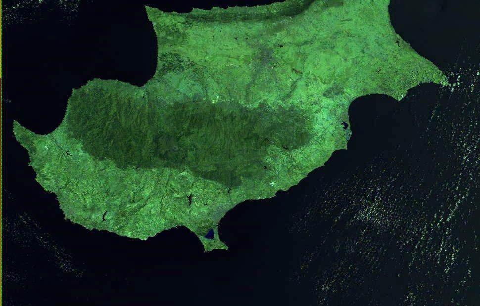
9 Geographical Intercalibration Groups (GIG) The intercalibration network must be confined to ecoregions ecoregions. Ecoregions can either be interpreted as those specified in Annex XI of the Directive (the Illies ecoregions for lakes and rivers, and much wider regions for coastal and transitional waters), or can be defined in a wider sense. For lakes: five Alpine, Mediterranean). For Alpine, GIG LM : : five intercalibration groups (Northern, Atlantic, Central, Spain (leader), Portugal, France, Italy, Greece, Cyprus and Romania
10 Rivers Lakes Transitional waters Coastal waters Heavily modified waters Selection of water types for each Ecoregion 1 Minimum 2 sites between high ---- good status 2 Selection of sites Using expert judgement on joint inspections & all available information Minimum 2 sites between good -- moderate status Draft register for Intercalibration network
11 Quality High border Select 2 or more sites from each country representing borders between high-good and good-moderate Good border Moderate [ High, Good, Moderate, Poor, Bad ] Pressure
12 common WFD assessment method in the GIG. In the L-M L M GIG, the common method comes to be the assessment of chlorophyll concentration from a sample collected at, or immediately below, the water surface, once in summer season. as an interim common method for IC purposes until a more sufficient method is implemented, in search of a more reliable outcome. More e specifically, an improved chlorophyll assessment method could be agreed among the GIG countries, increasing somewhat the annual number of samples and adopting a common sampling strategy. As an alternative approach to increased sampling, or in addition to it, satellite remote sensing imagery may provide a valuable tool in monitoring the variability of algal biomass and assessing the mean summer values of chlorophyll concentration at water surface.
13 The Geographic Intercalibration Group for Mediterranean Lakes, after the analysis of Problem of data availability, decided to develop during 2005 a special program for additional monitoring in the selected reservoirs, in general with information lacks. This Plan includes an special effort from the Member States providing several monitoring dates along the year supporting Remote Sensing activities ties to develop thematic mapping expanding the sampling points information in order to represent the whole water surface and permitting the assessment of the most t accurate mean summer Chlorophyll-a a and Phycocyanin concentration in the photic layer as expresion of eutrophication level, main pressure recognised in the Lakes of this Group. The site selected, setting the Ecological Quality borders high-good good and good- moderate, must represent as well as possible these boundaries to can compare with the other/s country/ies with reservoirs of the same Intercalibration type. In this frame is essential the role of Remote Sensing application n to provide comparable information on lakes along the summer period.

14
 50 reservoirs included in this")
15 European Union Water Framework Directive (EU WFD) Common Implementation Strategy (CIS) Intercalibration Exercise Geographic Intercalibration Group LM Mediterranean Lakes and Reservoirs (ES leader,, PT, FR, IT, GR, CY, RO) 50 reservoirs included in this process
16 In that frame, the GIG LM, leaded by Spain, and coordinated by Jose L. Ortiz (Ministry( of Environment), knowing the CEDEX experience in the Inland Water Phytoplankton Pigment Concentration assessment using Satellite Remote Sensing (MERIS and CHRIS imagery), specially the results achieved in the CHRIS activities developped along the year 2004 on Rosarito Reservoir, proposed this Project. The proposal includes 6 small reservoir selected from the 50 water bodies of the Group, located in three countries (Romania, Cyprus and Italy); in addition to the 4 smallest spanish selected reservoirs. The goal is optimize the evaluation of EQR* (ratio between actual and reference values) in function of mean summer concentration of Chlorophyll-a in the photic layer, adding the knowledge of distribution pattern along the water surface. * Ecological Quality Ratio
17 PROPOSED NEW EMPIRICAL MERIS ALGORITHM USING ROSARITO DATA (TO BE VALIDATED IN 2005) DATA DATA ROSARITO ROSARITO DATA DATA Lineal ( DATA) y = x R 2 = CHLOROPHYLL-a (mg m -3 ) Workshop on MERIS the Exploitation 9 / MERIS 7 of Data Products from the Compact High Resolution
18 Chlorophyll-a concentration... as expression of Trophic level 120 CORRELATION BETWEEN THE W14/W12 REFLECTANCE RATIO AND MEASURED CHLOROPHYLL-a CLOROPHYLL-A (mg m-3) y = x R 2 = Workshop on the W14/W12 Exploitation of Data Products from the Compact High Resolution
19 PROPOSED NEW EMPIRICAL MERIS ALGORITHM USING ROSARITO DATA (TO BE VALIDATED IN 2005) y = x R 2 = PHYCOCYANIN (mg m -3 ) PC FIELD ROSARITO MERIS 9 / MERIS 6

20 Chlorophyll-a concentration 20/05/ >250 mg m -3
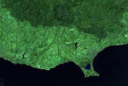
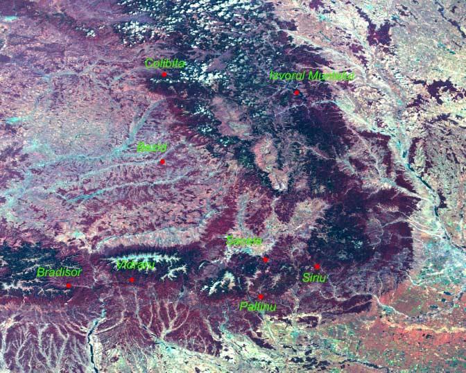
21 100 EVOLUTION OF MEASURED AND ESTIMATED CHLOROPHYLL-A (SAMPLING POINT B ) CHL-a (mg m -3 ) MEASURED CHL-a ESTIMATED CHL-a Summer period 0 22/04/ /05/ /06/ /07/ /08/ /09/ /10/ /11/2004 DATE
22 Phycocyanin concentration... as expression of Cyanobacterial pressure 350 CORRELATION BETWEEN THE W14/W9 REFLECTANCE RATIO AND MEASURED PHYCOCYANIN PHYCOCYANIN (mg m -3 ) y = x R 2 = Workshop on the Exploitation W14/W9 of Data Products from the Compact High Resolution
23 Phycocyanin concentration 20/05/ >250 mg m -3
24 350 EVOLUTION OF MEASURED AND ESTIMATED PHYCOCYANIN (SAMPLING POINT B ) PC (mg m -3 ) MEASURED PC ESTIMATED PC 50 Summer period 0 22/04/ /05/ /06/ /07/ /08/ /09/ /10/ /11/2004 DATE
25 Objectives for the WFD implementation: - Research and development of an operational system to evaluate the t mean summer concentration of Chlorophyll-a a in the photic layer using CHRIS image sets, in order to assess the Ecological Quality Status of water bodies, selected because are representing the boundaries between b high/good and good/moderate status, in the frame of the intercalibration exercise of WFD CIS in Mediterranean member countries. CHRIS-PROBA activities Objectives: - Mapping of Chlorophyll-a a temporal and spatial distribution, validating also several algorithms for Phycocyanin and other Phytoplankton pigments developed for MERIS bands. - Checking the correlation between the satellite derived data with the whole photic layer information. - Using the multiangular capabilities of PROBA to improve the model accuracy, study the Fresnel reflectance effects and provide the selection of radiometrically best angular images.
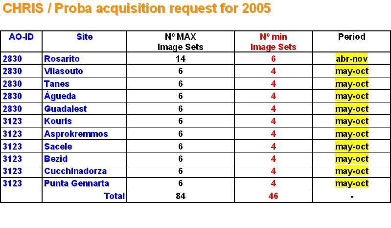
26 Ground campaigns tasks: - Monthly in summer period from May 2005 until October 2005 (adapted to CHRIS-Proba calendar), measuring: Phytoplankton taxonomic composition and biomass; Chlorophyll-a a and other Phytoplankton pigment composition; Nutrients concentration; Secchi disk depth transparency; Physicochemical parameters assessment. Imagery needs: - Quantity: desirable 1 image per month, preferably may-october october. - Type: Water bands, Mode 2. Full Swath, High Resolution, Multiangular (5 angles)
27 Proposal AO 2830 The Area of work includes: - Rosarito reservoir,, Central Spain, since april 2004; - Vilasouto reservoir,, in Galicia, Northwestern Spain; - Tanes reservoir,, in Asturias, Northern Spain; - Agueda reservoir,, in Castilla-Le León, Western Spain; - Guadalest reservoir,, in Valencia, Eastern Spain;

28 Site 4 Name & Location of site Tanes reservoir, Nalon river, Northern basins, Northern Spain Site 3 Center coordinates in decimal Degrees i.e Name & Location of site [two decimal points as minimum; Vilasouto North and reservoir, East = Mao river, Galician basins, positive; South and West = negative] northwestern Spain ; Center coordinates in decimal Altitude Degrees of site [metres i.e above sea level] [two decimal points as minimum; Preferred North date or and time East range = for data take (please per month may-oct if possible, always trying to positive; South and West indicate = negative] if associated with field work!) ; coincide the field work with the acquisition. Altitude of site [metres above Mode(s) sea level] Mode 2 Water bands; full resolution; full swath. Preferred Site date 2 or time range Would for you data prefer take the (please multi-angle 1 per 5-image month set may-oct or is a if possible, We prefers always multiangular trying to images, very useful in many indicate Name if associated & Location with nadir-image of field site work!) sufficient? coincide Agueda the field reservoir, work with cases, Agueda the selecting acquisition. river, Duero If the most basin, adequate Western angle. Since more than 1 site, please currently insert taking with a priority images Mode(s) Site 1 Mode Spain 2 Water bands; full European resolution; Water full ranking swath. Framework (Site 1 Directive. = Highest Geographic priority) Would Center you prefer coordinates the multi-angle Any in decimal additional 5-image Degrees information/remarks set i.e is a We prefers multiangular Intercalibration images, very useful Group. in many Mediterranean lakes Name Site of 5PI Ramón Peña-Martínez nadir-image [two decimal sufficient? points as minimum; Project North and East = Name Name cases, selecting the most adequate angle. & Location of site Use Guadalest of CHRIS reservoir, for Monitoring Guadalest Water river, Quality Jucar in basin, positive; South and West = negative] European Water ; Framework Directive. Selected Geographic Eastern Reservoirs Any additional Spain Altitude of information/remarks site [metres above sea ID level] within Center EOPI Intercalibration Group. Mediterranean lakes coordinates in decimal Degrees i.e Preferred date or time range for data Name take (please 1 per month may-oct if possible, always trying to [two & decimal Location points of site as minimum; North and East = Rosarito reservoir, Tietar river, Central Spain indicate if associated with field work!) Center coincide the field work with the acquisition. positive; coordinates South and in decimal West = Degrees negative] i.e ; Mode(s) [two Mode 2 Water bands; full resolution; full swath. Altitude decimal of points site [metres as minimum; above North sea level] East = Would you prefer the multi-angle positive; 5-image set or is a prefers multiangular images, very useful in many Preferred South date and or West time = range negative] for data take (please 1 per ; month may-oct if possible, always trying to nadir-image sufficient? Altitude cases, selecting the most adequate angle. indicate of site if associated [metres above with field sea level] work!) coincide the field work with the acquisition. Preferred European Water Framework Directive. Geographic Mode(s) date or time range for data take (please 1 per Mode month, 2 Water 2 per month bands; may-oct full resolution; if possible, full swath. always Any additional information/remarks indicate Intercalibration Group. Mediterranean lakes Would if associated you prefer with the multi-angle field work!) 5-image set or is trying a We to prefers coincide multiangular the field work images, with very the acquisition. useful in many Mode(s) nadir-image sufficient? Mode cases, 2 Water selecting bands; the full most resolution; adequate full angle. swath. Would you prefer the multi-angle 5-image set or is a We European prefers multiangular Water Framework images, very Directive. useful in Geographic many nadir-image Any additional Workshop sufficient? information/remarks on the Exploitation of Data cases, Products Intercalibration selecting from the Group. most the Compact adequate Mediterranean angle. High Resolution lakes Cyanobacteria assessment and evolution control; (21-23 March Any 2005, additional ESRIN. information/remarks Frascati,, Italy) MERIS algorithms validation.
29 Proposal AO 3123 The Area of work includes: -Kouris reservoir and -Asprokremmos reservoir,, in Cyprus Island; -Sacele reservoir and -Bezid reservoir,, in Romania; -Punta Gennarta reservoir and -Cucchinadorza reservoir,, in Sardegna Island, Italy

30 Bezid Res. Sacele Res. Cucchinadorza Res. Punta Gennarta Res. Asprokremmos Res. Kouris Res.

31 Kouris Res. Asprokremmos Res.
32
33 Site 2 Name & Location of site Asprokremmos reservoir, Cyprus island Center coordinates in decimal Degrees i.e [two decimal points as minimum; North and East = positive; South and West = negative] ; ETRS89 Altitude of site [metres above sea level] Preferred date or time range for data take (please 1 per month may-oct if possible, always trying to indicate if associated with field work!) coincide the field work with the acquisition. Mode(s) Mode 2 Water bands; full resolution; full swath. Would you prefer the multi-angle 5-image set or is a We prefers multiangular images, very useful in many nadir-image sufficient? cases, selecting the most adequate angle. European Water Framework Directive. Geographic Any additional information/remarks Intercalibration Group. Mediterranean lakes
34

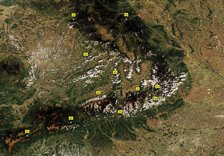
35 Bezid Res. Sacele Res.
36 Site 3 Name & Location of site Sacele reservoir, Romania Center coordinates in decimal Degrees i.e [two decimal points as minimum; North and East = positive; South and West = negative] ; ETRS89 Altitude of site [metres above sea level] Preferred date or time range for data take (please 1 per month may-oct if possible, always trying to indicate if associated with field work!) coincide the field work with the acquisition. Mode(s) Mode 2 Water bands; full resolution; full swath. Would you prefer the multi-angle 5-image set or is a We prefers multiangular images, very useful in many nadir-image sufficient? cases, selecting the most adequate angle. European Water Framework Directive. Geographic Any additional information/remarks Intercalibration Group. Mediterranean lakes
37 Site 4 Name & Location of site Bezid reservoir, Romania Center coordinates in decimal Degrees i.e [two decimal points as minimum; North and East = positive; South and West = negative] ; ETRS89 Altitude of site [metres above sea level] Preferred date or time range for data take (please 1 per month may-oct if possible, always trying to indicate if associated with field work!) coincide the field work with the acquisition. Mode(s) Mode 2 Water bands; full resolution; full swath. Would you prefer the multi-angle 5-image set or is a We prefers multiangular images, very useful in many nadir-image sufficient? cases, selecting the most adequate angle. European Water Framework Directive. Geographic Any additional information/remarks Intercalibration Group. Mediterranean lakes

38 Cucchinadorza Res. Punta Gennarta Res.
39 Site 5 Name & Location of site Bacino di Punta Gennarta, Sardegna island Center coordinates in decimal Degrees i.e [two decimal points as minimum; North and East = positive; South and West = negative] ; ETRS89 Altitude of site [metres above sea level] Preferred date or time range for data take (please 1 per month may-oct if possible, always trying to indicate if associated with field work!) coincide the field work with the acquisition. Mode(s) Mode 2 Water bands; full resolution; full swath. Would you prefer the multi-angle 5-image set or is a We prefers multiangular images, very useful in many nadir-image sufficient? cases, selecting the most adequate angle. European Water Framework Directive. Geographic Any additional information/remarks Intercalibration Group. Mediterranean lakes
40 Site 6 Name & Location of site Bacino di Cucchinadorza, Sardegna island Center coordinates in decimal Degrees i.e [two decimal points as minimum; North and East = positive; South and West = negative] ; ETRS89 Altitude of site [metres above sea level] Preferred date or time range for data take (please 1 per month may-oct if possible, always trying to indicate if associated with field work!) coincide the field work with the acquisition. Mode(s) Mode 2 Water bands; full resolution; full swath. Would you prefer the multi-angle 5-image set or is a We prefers multiangular images, very useful in many nadir-image sufficient? cases, selecting the most adequate angle. European Water Framework Directive. Geographic Any additional information/remarks Intercalibration Group. Mediterranean lakes
41 Ground campaigns: - Monthly in summer period: from May 2005 until October 2005 (adapted to CHRIS-Proba calendar), measuring: Phytoplankton taxonomic composition, biovolume and biomass; Chlorophyll ll-a a and other Phytoplankton pigment composition; Nutrients concentration; Physicochemical parameters analysis. Cyanotoxins toxicity tests - Water optics (eventually eventually): Above water radiometry (multiangular ( reflectance measurements) In water radiometry (upwelling ( and downwelling irradiance profiles) The in situ campaigns will be conducted by each Member State Water Authorities Scientific Branch, responsible any case of Ecological Water Quality Assessment in order to compare with the other countries in the Intercalibration Exercise. The general coordination is conducted by Spain (Ministry of Environment)
42 Receiving imagery and monitoring data from members: - CEDEX will coordinate the Plan to Monitor each water body, considering the Viewing opportunities and the Active Plan of CHRIS/Proba, to guarantee the most of coincidence as possible between field data and images sets. - Processing the image sets and applying the Algorithms developped for the evaluation of pigment concentration. - Validating the results with the field data. - Thematic mapping of Chlorophyll-a, Phycocyanin,, etc. In order to assess mean concentration values for each date and finally for the summer period. - This Mean Summer concentration values will provide the value of Ecological Status: The monitoring results for the biological quality elements are expressed as EQRs - ratios derived from observed values and reference* values. * In reference conditions.
43 Very important Question in the frame of GIG LM: How is the Correlation between Chlorophyll-a a concentration in the upper layer 0.5 meter, or first optical thickness (~ 0.6 * SD) and mean concentration in the whole photic layer?
44 Correlation : Mean CHLa (1st opt. thi.) / Mean CHLa photic layer y = 1,0566x R 2 = 0, CHLa pho lay CHLa 1st opt. thi.
45 Correlation : Mean CHLa (1st opt. thi.) / Mean CHLa photic layer y = 1,0566x R 2 = 0, CHLa pho lay Burguillo CLF teledetección
46
47 Correlation : Mean CHLa (1st opt. thi.) / Mean CHLa photic layer y = 1,0566x R 2 = 0, CHLa pho lay Riaño CHLa 1st opt. thi.
48
49 Correlation : Mean CHLa (1st opt. thi.) / Mean CHLa photic layer y = 1,0566x R 2 = 0, CHLa pho lay El Atazar CHLa 1st opt. thi.

50
51 Correlation : Mean CHLa (1st opt. thi.) / Mean CHLa photic layer y = 1,0566x R 2 = 0, CHLa pho lay CHLa 1st opt. thi.
52 Summarize lines: Starting from the Rosarito_reservoir successful experience during 2004, and applying that achievements to new inland water goals. In the frame of the Water Directive, use the CHRIS capabilities to expand and optimize the Chlorophyll an Phycocyanin concentration mapping in selected water bodies. Understanding the possible conflicts with other sites, expecting the best chance as possible for rise the objectives in the 2005 acquisition requests s frame.
53 PI : Peña-Martínez, Ramón
MAPPING OF PHOTOSYNTHETIC PIGMENTS IN SPANISH RESERVOIRS
 MAPPING OF PHOTOSYNTHETIC PIGMENTS IN SPANISH RESERVOIRS Ramón Peña-Martínez, José Antonio Domínguez-Gómez, Caridad de Hoyos, Antonio Ruiz-Verdú Centro de Estudios Hidrográficos del CEDEX, Pº Bajo de la
Goals of the GLOWA Volta Project:
 GLOWAVolta Monitoring of Chlorophyll a and Toxic Algal Blooms in the Volta Basin Preliminary regarding potentials of CHRIS-Proba hyperspectral imagery Content: 1. Introduction 1.1 GLOWA Volta Project/
Verdú,, Antonio Spain)
") L-M M GIG 6th Meeting. CEMAGREPH, Aix-en Provence (FR). 18-19 19 May 26 Comparison of biological data from photic-layer integrated data with similar information from upper water layers Authors: Peña-Mart
L-M M GIG 6th Meeting. CEMAGREPH, Aix-en Provence (FR). 18-19 19 May 26 Comparison of biological data from photic-layer integrated data with similar information from upper water layers Authors: Peña-Mart
INTERCALIBRATION OF PHYTOPLANKTON IN TRAC WATERS. Shane O Boyle and Georgina McDermott Aquatic Environment EPA, Richview, Dublin, 12 October 2011
 INTERCALIBRATION OF PHYTOPLANKTON IN TRAC WATERS Shane O Boyle and Georgina McDermott Aquatic Environment EPA, Richview, Dublin, 12 October 2011 The problem eutrophication in TRAC waters The problem eutrophication
Study of Water Quality using Satellite data
 2nd Workshop on Parameterization of Lakes in Numerical Weather Prediction and Climate Modelling Study of Water Quality using Satellite data M. Potes, M. J. Costa (Évora Geophysics Centre, PORTUGAL) This
COMMON IMPLEMENTATION STRATEGY FOR THE WATER FRAMEWORK DIRECTIVE (2000/60/EC)
") COMMON IMPLEMENTATION STRATEGY FOR THE WATER FRAMEWORK DIRECTIVE (2000/60/EC) POLICY SUMMARY to Guidance Document No 10 Produced by Working Group 2.3 - REFCOND Explanatory Note This policy summary gives
COMMON IMPLEMENTATION STRATEGY FOR THE WATER FRAMEWORK DIRECTIVE (2000/60/EC) POLICY SUMMARY to Guidance Document No 10 Produced by Working Group 2.3 - REFCOND Explanatory Note This policy summary gives
Great Lakes Remote Sensing Algorithms
 Great Lakes Remote Sensing Algorithms Status, Comparisons, and Future Directions Robert Shuchman MTRI Mike Sayers MTRI George Leshkevich NOAA/GLERL Barry Lesht JGLR/Assoc. Editor Caren Binding Environment
WFD Stakeholder Meeting 4 May 2006: Classification/Environmental Standards. Rob Hitchen WFD Team, Defra
 WFD Stakeholder Meeting 4 May 2006: Classification/Environmental Standards Rob Hitchen WFD Team, Defra Reminder - What is Classification? WFD requires that water bodies are classified (ie. assigned a status
Common Implementation Strategy for the Water Framework Directive (2000/60/EC)
") European Commission Common Implementation Strategy for the Water Framework Directive (2000/60/EC) Guidance document n. o 6 Towards a guidance on establishment of the intercalibration network and the process
European Commission Common Implementation Strategy for the Water Framework Directive (2000/60/EC) Guidance document n. o 6 Towards a guidance on establishment of the intercalibration network and the process
Remote sensing for aquatic habitat quality mapping and EU Water Framework Directive (EU-WFD) reporting
 reporting") Remote sensing for aquatic habitat quality mapping and EU Water Framework Directive (EU-WFD) reporting S. C. J. Palmer 1,2, A. Zlinszky 1, H. Balzter 2, V. R. Tóth 1 1 Balaton Limnological Institute, Hungarian
Remote sensing for aquatic habitat quality mapping and EU Water Framework Directive (EU-WFD) reporting S. C. J. Palmer 1,2, A. Zlinszky 1, H. Balzter 2, V. R. Tóth 1 1 Balaton Limnological Institute, Hungarian
Towards implementation of Earth Observationbased water quality monitoring and assessment: case of Lithuanian surface waters
 Towards implementation of Earth Observationbased water quality monitoring and assessment: case of Lithuanian surface waters D i a n a Va i č i ū t ė K l a i p ė d a U n i v e r s i t y d i a n a.v a i
Zu-Tao Ou-Yang Center for Global Change and Earth Observation Michigan State University
 Zu-Tao Ou-Yang Center for Global Change and Earth Observation Michigan State University Ocean Color: Spectral Visible Radiometry Color of the ocean contains latent information on the water qualitycdom,
European Forest Fire Information System (EFFIS) - Rapid Damage Assessment: Appraisal of burnt area maps with MODIS data
 - Rapid Damage Assessment: Appraisal of burnt area maps with MODIS data") European Forest Fire Information System (EFFIS) - Rapid Damage Assessment: Appraisal of burnt area maps with MODIS data Paulo Barbosa European Commission, Joint Research Centre, Institute for Environment
European Forest Fire Information System (EFFIS) - Rapid Damage Assessment: Appraisal of burnt area maps with MODIS data Paulo Barbosa European Commission, Joint Research Centre, Institute for Environment
Harmful Algal Blooms (HABs) 2 methods
 2 methods") Harmful Algal Blooms (HABs) 2 methods Richard P. Stumpf NOAA, National Ocean Service HAB occurrences worldwide Image from whoi.edu/redtide Remote Sensing for HAB Detection: Does the Bloom Change Water
Harmful Algal Blooms (HABs) 2 methods Richard P. Stumpf NOAA, National Ocean Service HAB occurrences worldwide Image from whoi.edu/redtide Remote Sensing for HAB Detection: Does the Bloom Change Water
METODOLOGIE E APPROCCI PER OSSERVAZIONI IPERSPETTRALI IN ACQUE COSTIERE E INTERNE
 Data Exploitation della missione PRISMA, precursore delle missioni iperspettrali nazionali Roma, 1-3 marzo 2017 METODOLOGIE E APPROCCI PER OSSERVAZIONI IPERSPETTRALI IN ACQUE COSTIERE E INTERNE Federica
CONCLUSIONS AND RECOMMENDATIONS
 UNEP/DEPI/MED WG.342/3 7 December 2009 ENGLISH MEDITERRANEAN ACTION PLAN Meeting of MEDPOL experts Marine Pollution Indicators to assess ecosystem stress (Biological Quality Elements) Athens, 12 October
Water Framework Directive intercalibration technical report
 JRC Scientific and Technical Reports Water Framework Directive intercalibration technical report Part 2: Lakes Edited by Sandra Poikane EUR 23838 EN/2-2009 JRC Scientific and Technical Reports Water Framework
Remote Sensing of Environment
 Remote Sensing of Environment 112 (2008) 3996 4008 Contents lists available at ScienceDirect Remote Sensing of Environment journal homepage: www.elsevier.com/locate/rse An evaluation of algorithms for
WATER FRAMEWORK DIRECTIVE COMMON IMPLEMENTATION STRATEGY VALENCIA -REMOC -NOV
 WATER FRAMEWORK DIRECTIVE COMMON IMPLEMENTATION STRATEGY VALENCIA -REMOC -NOV 2003 1 WFD: WHY A COMMON IMPLEMENTATION STRATEGY? Challenges widely shared by the Member States Demanding timetable Complexity
2018 Sebago Lake Assessment
 2018 Sebago Lake Assessment Portland Water District Sebago Lake Watershed Monitoring Programs Lake Monitoring Presenting data from 1976 to 2018 Nathan Whalen Introduction Sebago Lake is the primary drinking
Assessing Lake Clarity...from SPACE...
 Assessing Lake Clarity...from SPACE... Taylor Long Peter Marinello December 10, 2012 Why look at lakes from space?... Lake Clarity Indicative of Water Quality Monitoring time consuming and expensive Satellite
Monitoring water quality of the Southeastern Mediterranean sea using remote sensing
 Monitoring water quality of the Southeastern Mediterranean sea using remote sensing Tamir Caras The Remote Sensing Laboratory Jacob Blaustein Institutes for Desert Research Ben-Gurion University of the
Indicator Fact Sheet (WEC05) Demonstration indicator: biological quality of lakes
 Demonstration indicator: biological quality of lakes") Indicator Fact Sheet (WEC05) Demonstration indicator: biological quality of lakes Author: Attila Lázár, Vituki Consult, Jens Bogestrand, NERI EEA project manager: Niels Thyssen version 01.10.03 Key message
Indicator Fact Sheet (WEC05) Demonstration indicator: biological quality of lakes Author: Attila Lázár, Vituki Consult, Jens Bogestrand, NERI EEA project manager: Niels Thyssen version 01.10.03 Key message
Implementation of the European Water. and. Freshwater Biodiversity. Gorazd URBANIČ. IzVRS - Institute for Waters of the Republic of Slovenia
 EPBRS srečanje/epbrs Meeting Brdo (Slovenija), 16. 18.1.2008 Implementation of the European Water Framework Directive and Consequences for Freshwater Biodiversity Gorazd URBANIČ IzVRS - Institute for Waters
Developing the next generation of coastal water quality products and services - the FP7/HIGHROC project
 Developing the next generation of coastal water quality products and services - the FP7/HIGHROC project K. Ruddick, C. Brockmann, E. Capuzzo, K. Collingridge, S. Constantin, V. Créach, L. De Keukelaere,
Water Framework Directive scientific and technical support related to ecological status
 Water Framework Directive scientific and technical support related to ecological status Summary report of JRC activities in 2015 Wouter van de Bund Sandra Poikane 2015 EUR 27707 EN This publication is
The implementation of Water Framework Directive (WFD) in Greece Linking WFD with coastal water protection
 in Greece Linking WFD with coastal water protection") The implementation of Water Framework Directive (WFD) in Greece Linking WFD with coastal water protection Anastasia Lazarou Dr. Chemist Athens, 19 January 2007 Basic Directives related with the protection
The implementation of Water Framework Directive (WFD) in Greece Linking WFD with coastal water protection Anastasia Lazarou Dr. Chemist Athens, 19 January 2007 Basic Directives related with the protection
SURFACE REFLECTANCE AND UNDERWATER DOWNWELLING IRRADIANCE IN ALQUEVA RESERVOIR, SOUTHEAST PORTUGAL
 SURFACE REFLECTANCE AND UNDERWATER DOWNWELLING IRRADIANCE IN ALQUEVA RESERVOIR, SOUTHEAST PORTUGAL M. Potes, R. Salgado, M. J. Costa, M. Morais, D. Bortoli and I. Kostadinov Institute of Earth Sciences
H2020 SENSAGRI project: developing prototypes for new Copernicus services for agriculture
 GEOINT for Environmental Compliance Assurance in rural areas/agriculture H2020 SENSAGRI project: developing prototypes for new Copernicus services for agriculture Antonio Ruiz Verdú University of Valencia
THE WATER FRAMEWORK DIRECTIVE TRANSITIONAL AND COASTAL WATERS
 THE WATER FRAMEWORK DIRECTIVE TRANSITIONAL AND COASTAL WATERS SUMMARY 1.The Directive 2000/60/EC of the European Parliament and of the Council of 23 October 2000 2. Common Implementation Strategy, CIS
code: code: HICO Data User's Proposal Title of Proposal Principal Investigator Jose F. Moreno University of Valencia
 HICO Data User's Proposal Title of Proposal *USE OF HTCO DATA TO STUDY THE WATER QUALITY OF COASTAL AND INLAND WATER BODIES' Principal Investigator Jose F. Moreno University of Valencia Address Depart.
Temporal Relationship Between Landsat 8 Spectral Reflectance and Transparency in Grand Lake O' the Cherokee
 Temporal Relationship Between Landsat 8 Spectral Reflectance and Transparency in Grand Lake O' the Cherokee 37 TH Annual Oklahoma Governor s Water Conference October 11 th 12 th, 2016 Norman, Oklahoma
MODEL IMPLEMENTATION AND QUANTIFICATION OF THE EUTROPHICATION RISK ASSOCIATED TO THE USE OF PHOSPHATES IN DETERGENTS
 DEVELOPMENT OF AN EUROPEAN QUANTITATIVE EUTROPHICATION RISK ASSESSMENT OF POLYPHOSPHATES IN DETERGENTS MODEL IMPLEMENTATION AND QUANTIFICATION OF THE EUTROPHICATION RISK ASSOCIATED TO THE USE OF PHOSPHATES
Water Quality Analysis of Lakewood Lakes
 Water Quality Analysis of Lakewood Lakes December 2016 Prepared by WEST Consultants, Inc. Bellevue, Washington With support from HDR, Inc., Olympia, Washington TABLE OF CONTENTS EXECUTIVE SUMMARY... V
Estimating Primary Productivity with WIM/WAM
 Estimating Primary Productivity with WIM/WAM Mati Kahru 2008 1 Estimating Primary Productivity with WIM/WAM Contents Estimating Primary Productivity with WIM/WAM... 1 1 Introduction... 1 2 Prerequisites...
State of Environment reporting on water and the Water Information System for Europe (WISE)
") WFD Lille 2007 State of Environment reporting on water and the Water Information System for Europe (WISE) Stefan Jensen EEA Agenda EEA needs for SoE reporting and water data Indicator based assessments
WFD Lille 2007 State of Environment reporting on water and the Water Information System for Europe (WISE) Stefan Jensen EEA Agenda EEA needs for SoE reporting and water data Indicator based assessments
NERC Knowledge Exchange Fellowship: Exploitation of satellite remote sensing for regulation and monitoring of inland water quality
 NERC Knowledge Exchange Fellowship: Exploitation of satellite remote sensing for regulation and monitoring of inland water quality Dr Claire Neil, Biological & Environmental Sciences, University of Stirling
Global Lakes Sentinel Services GLASS-S3VT
 www.glass-project.eu Global Lakes Sentinel Services GLASS-S3VT Water Insight (A. Hommersom, S. Peters, K. Poser), SYKE (S. Koponen, K. Kallio), EOMAP (T. Heege, K. Schenk, S. Ohlendorf), VU University
Monitoring and Predicting Eutrophication of Inland Waters Using Remote Sensing
 Monitoring and Predicting Eutrophication of Inland Waters Using Remote Sensing Shabani Marijani Mssanzya February, 2010 Monitoring and Predicting Eutrophication of Inland Waters Using Remote Sensing by
Satellite Monitoring of Water Quality in Lake Manzalah, Egypt. Real-Time Water Quality Monitoring Workshop June St.
 Satellite Monitoring of Water Quality in Lake Manzalah, Egypt Real-Time Water Quality Monitoring Workshop June 16-17 2009 St. John s, Canada Motivation Lakes are vital component of Egypt s water resources
Future remote sensors for chlorophyll a. Dimitry Van der Zande, Quinten Vanhellemont & Kevin Ruddick
 Future remote sensors for chlorophyll a Dimitry Van der Zande, Quinten Vanhellemont & Kevin Ruddick Workshop Scheldt Commission: eutrophication 20 th October 2016 Ocean colour from space ESA MERIS 7 May
EU FP7-SPACE project INFORM
 Improvedmonitoring andforecastingof ecologicalstatus of European INland waters by combining Future earth ObseRvation data and Models Miguel Dionisio Pires Deltares miguel.dionisio@deltares.nl EU FP7-SPACE
Prepared by: Hana Prchalova, Silvie Semeradova, Shane Hume, Pavla Chyska Organisation: ETC/W - CENIA
 Ref. Ares(2010)830345 Ares(2010)835550-18/11/2010 EEA/ADS/06/001 Water Comparison of NiD/WFD/SoE Nitrate Reporting EEA ETC/Water Technical report Version: 1.3 Date: 16.11.2010 EEA activity: 1.4.1 ETC/Water
Explanatory Note. Interim Classification of Irish Coastal and Transitional Waters for the purposes of the EU Water Framework Directive.
 Explanatory Note Interim Classification of Irish Coastal and Transitional Waters for the purposes of the EU Water Framework Directive. Introduction November 2008 The EU Water Framework Directive (2000/60/EC)
Naomi Feger SF Bay RWQCB January 6, 2017
 Harmful Algal Blooms North Bay Watershed Association January Meeting Naomi Feger SF Bay RWQCB January 6, 2017 Why are Harmful Algal Blooms (HABs) a Problem in California HABs create significant water quality
Diatom/Dinoflagellate Ratio
 Diatom/Dinoflagellate Ratio Concept: Norbert Wasmund, IOW/Germany, partly based on Klais et al. 2011 (Est., FI); support from national WG on Eutrophication, Nutrients and Plankton Interest signalled also
EU Water Framework Directive
 EU Water Framework Directive Overview and state of implementation TAIEX Seminar on the Water Framework and Urban Waste Water Directive Zagreb, 25-26 September 2008 Jorge Rodríguez Romero European Commission,
Remote Sensing of Inland Lake Harmful Algal Blooms
 Remote Sensing of Inland Lake Harmful Algal Blooms Linda Novitski Cooperative Institute for Limnology and Ecosystems Research Ann Arbor, Michigan May 2, 2014 Talk Outline Introduction to harmful algal
Multimetric Phytoplankton Index (MPI): description of the method and study cases in Mediterranean Sea.
: description of the method and study cases in Mediterranean Sea.") Multimetric Phytoplankton Index (MPI): description of the method and study cases in Mediterranean Sea. Chiara FACCA1, Fabrizio BERNARDI AUBRY2, Stefania FINOTTO2, Emanuele PONIS3, Francesco ACRI2, Adriano
Multimetric Phytoplankton Index (MPI): description of the method and study cases in Mediterranean Sea. Chiara FACCA1, Fabrizio BERNARDI AUBRY2, Stefania FINOTTO2, Emanuele PONIS3, Francesco ACRI2, Adriano
Mati River Basin Management Plan
 Commission of European Communities, for and on behalf of the Government of Albania, Ref.: EuropeAid/124909/C/SER/AL Implementation of the National Plan for Approximation of Environmental Legislation in
Satellite Remote Sensing of Algal Blooms in the southcentral USA:
 Satellite Remote Sensing of Algal Blooms in the southcentral USA: Landsat 8 based algal and turbidity indices in the Grand Lake watershed Abu Mansaray, Doctoral Candidate Environmental Science Graduate
 Fernando Gilbes 1, William Hernández, Natlee Hernández, José Martínez, and Vilmaliz Rodriguez Geological and Environmental Remote Sensing Lab Department of Geology University of Puerto Rico at Mayagüez
1. GENERAL INFORMATION
 EN EN 1. GENERAL INFORMATION Figure 1.1: Map of River Basin Districts International River Basin Districts (within EU) International River Basin Districts (outside EU) National River Basin Districts (within
Estimating Michigan s Trophic State Trends with Satellite Imagery USGS Recent Inland Lake Studies
 Estimating Michigan s Trophic State Trends with Satellite Imagery USGS Recent Inland Lake Studies Lori Fuller USGS Michigan-Ohio Water Science Center 2016 Michigan Inland Lakes Convention April 29, 2016
DEVELOPMENT OF MERIS LAKE WATER ALGORITHMS: VALIDATION RESULTS FROM EUROPE
 DEVELOPMENT OF MERIS LAKE WATER ALGORITHMS: VALIDATION RESULTS FROM EUROPE Antonio Ruiz-Verdú (1,2), Sampsa Koponen (3), Thomas Heege (4), Roland Doerffer (5), Carsten Brockmann (6), Kari Kallio (7), Timo
Flash Eurobarometer on water. Analytical report
 Flash Eurobarometer 261 The Gallup Organisation Analytical Report Flash EB N o 251 Public attitudes and perceptions in the euro area Flash Eurobarometer European Commission Flash Eurobarometer on water
WFD Intercalibration technical report. Part 2 Lakes Section 3 Phytoplankton composition
 WFD Intercalibration technical report Part 2 Lakes Section 3 Phytoplankton composition 1 Contents 1. Introduction... 2. Methodology and results 2.1. Alpine GIG... 2.1.1. Alpine Lake types... 2.1.2. Intercalibration
Satellite Remote Sensing for water quality assessment and monitoringan overview on current concepts, deficits and future tasks
 Proceedings of the 2nd WSEAS International Conference on Remote Sensing, Tenerife, Canary Islands, Spain, December 16-18, 2006 61 Satellite Remote Sensing for water quality assessment and monitoringan
NASA DEVELOP National Program Focusing on Partnerships with project example
 National Aeronautics and Space Administration NASA Ames Research Center NASA DEVELOP National Program Focusing on Partnerships with project example Jenna Williams Center Lead Where DEVELOP Fits @ NASA
Trans-boundary river basins in Spain and Portugal: The Albufeira Agreement
 Trans-boundary river basins in Spain and Portugal: The Albufeira Agreement Teodoro Estrela Deputy Water Director Ministry of Environment, and Rural and Marine Affairs REMOC MENBO REMOB Red MEditerránea
Water clarity. Key Message
 Water clarity Key Message HELCOM core indicator report July 2018 This core indicator evaluates water clarity based on average Secchi depth during summer (June September) during the assessment period 2011-2016.
EUROPEAN COMMISSION HEALTH AND FOOD SAFETY DIRECTORATE-GENERAL
 EUROPEAN COMMISSION HEALTH AND FOOD SAFETY DIRECTORATE-GENERAL Health systems, medical products and innovation Medicines: policy, authorisation and monitoring PHARM 723 PHARMACEUTICAL COMMITTEE 18 October
BIOLOGY TERC.UCDAVIS.EDU
 10 Algae growth (primary productivity) Yearly since 1959 Primary productivity is a measure of the rate at which algae produce biomass through photosynthesis. It was first measured at Lake Tahoe in 1959
EO Information Services. Zambezi River Basin Mapping
 EO Information Services in support of Zambezi River Basin Mapping Corné van der Sande, NEO BV Nick van de Giesen, TUDelft Kathrin Poser & Steef Peters Water Insight BV End User Workshop February 10, 2012
CLIMATE CHANGE CHALLENGES TO WATER MANAGEMENT IN JUCAR RIVER BASIN AUTHORITY. Juan José Moragues Terrades President of the Júcar River Basin Authority
 CLIMATE CHANGE CHALLENGES TO WATER MANAGEMENT IN JUCAR RIVER BASIN AUTHORITY Juan José Moragues Terrades President of the Júcar River Basin Authority WATER FRAMEWORK DIRECTIVE Meeting of the European River
Aqaba Projects Partner Country Priorities NATO Forum
 Aqaba Projects Partner Country Priorities NATO Forum March 12 th 2008 Mohammad Badran and Mohammad Al Zibdah Marine Science Station; University of Jordan / Yarmouk University, Aqaba Jordan. 3/12/2008 1
1. GENERAL INFORMATION
 EN EN 1. GENERAL INFORMATION Figure 1.1: Map of River Basin District International River Basin Districts (within EU) International River Basin Districts (outside EU) National River Basin Districts (within
INTERNATIONAL NETWORKS of BASIN ORGANIZATIONS Debrecen (Hungary) June 2007
 June 2007") INTERNATIONAL NETWORKS of BASIN ORGANIZATIONS Debrecen (Hungary) June 2007 Flood Management in Spain: case of Tagus River Justo Mora A.-Muñoyerro Tagus River Basin Authority Spanish Ministry of Environment
INTERNATIONAL NETWORKS of BASIN ORGANIZATIONS Debrecen (Hungary) June 2007 Flood Management in Spain: case of Tagus River Justo Mora A.-Muñoyerro Tagus River Basin Authority Spanish Ministry of Environment
Determining the Most Appropriate Classification Methods for Water Quality
 IOP Conference Series: Earth and Environmental Science PAPER OPEN ACCESS Determining the Most Appropriate Classification Methods for Water Quality To cite this article: Önder Gürsoy 2016 IOP Conf. Ser.:
IRENA Indicator Fact Sheet IRENA 10 - Water use intensity
 Indicator Definition Water use intensity by agriculture is indicated by the area and type of crops grown with the aid of full or supplementary irrigation. Indicator links Input Indicator Links: None Output
EASTERN CONTINENTAL LAKE GIG PHYTOPLANKTON (14 March 2014) Table of contents
 Table of contents") 1 EASTERN CONTINENTAL LAKE GIG PHYTOPLANKTON (14 March 2014) Table of contents Description of member states assessment methods HU. 2 Hungarian classification method for phytoplankton in lakes... 2 Summary...
1 EASTERN CONTINENTAL LAKE GIG PHYTOPLANKTON (14 March 2014) Table of contents Description of member states assessment methods HU. 2 Hungarian classification method for phytoplankton in lakes... 2 Summary...
COMMON IMPLEMENTATION STRATEGY FOR THE WATER FRAMEWORK DIRECTIVE (2000/60/EC)
") Technical Report - 2009-030 COMMON IMPLEMENTATION STRATEGY FOR THE WATER FRAMEWORK DIRECTIVE (2000/60/EC) Guidance Document No. 23 GUIDANCE DOCUMENT ON EUTROPHICATION ASSESSMENT IN THE CONTEXT OF EUROPEAN
Technical Report - 2009-030 COMMON IMPLEMENTATION STRATEGY FOR THE WATER FRAMEWORK DIRECTIVE (2000/60/EC) Guidance Document No. 23 GUIDANCE DOCUMENT ON EUTROPHICATION ASSESSMENT IN THE CONTEXT OF EUROPEAN
USING MERIS DATA FOR THE RETRIEVAL OF CHL A, CDOM AND TSS VALUES IN THE GULF OF FINLAND AND LAKE LOHJANJÄRVI
 USING MERIS DATA FOR THE RETRIEVA OF CH A, CDOM AND TSS VAUES IN THE GUF OF FINAND AND AKE OHJANJÄRVI Sampsa Koponen 1, Jenni Vepsäläinen 2, Jouni Pulliainen 1, Kari Kallio 2, Timo Pyhälahti 2, Antti indfors
CAP CONTEXT INDICATORS
 CAP CONTEXT INDICATORS 2014-2020 40. WATER QUALITY 2017 update CONTEXT INDICATOR 40: WATER QUALITY Water quality is assessed through the Gross Nutrient Balance and nitrates in freshwater The nitrogen surplus
MARCOAST ADRIATIC SERVICE MERIS PRODUCTS VALIDATION
 MARCOAST ADRIATIC SERVICE MERIS PRODUCTS VALIDATION Monique Viel (), Giulio Ceriola (), Paolo Manunta (), Raffaella Matarrese (3), Vito De Pasquale (), Guido Pasquariello () Planetek Italia srl, Via Massaua,
Water Framework Directive Intercalibration Technical Report
 Water Framework Directive Intercalibration Technical Report Central Baltic Lake Phytoplankton ecological assessment methods Geoff Phillips, Gary Free, Ivan Karottki, Christophe Laplace-Treyture, Kairi
CLIMATE CHANGE CHALLENGES TO WATER MANAGEMENT IN JUCAR RIVER BASIN AUTHORITY. Juan José Moragues Terrades President of the Júcar River Basin Authority
 CLIMATE CHANGE CHALLENGES TO WATER MANAGEMENT IN JUCAR RIVER BASIN AUTHORITY Juan José Moragues Terrades President of the Júcar River Basin Authority WATER FRAMEWORK DIRECTIVE Meeting of the European River
The nature (peculiarities) of biooptical/biogeochemical. measurements in the context of Argo QC and data management.
 of biooptical/biogeochemical. measurements in the context of Argo QC and data management.") The nature (peculiarities) of biooptical/biogeochemical data and of their measurements in the context of Argo QC and data management Hervé Claustre Prerequisite for Bio-Argo DM: We should follow as much
The nature (peculiarities) of biooptical/biogeochemical data and of their measurements in the context of Argo QC and data management Hervé Claustre Prerequisite for Bio-Argo DM: We should follow as much
DRAFT. DRAFT July 9, 2013 Lake-Wide Survey (No. 8) Page 1 of Cayuga Lake. Lake-Wide Seabird Profiles
 Page 1 of Cayuga Lake. Lake-Wide Seabird Profiles") Cayuga Lake Lake-Wide Seabird Profiles July 9, Provisional Data Summary Submitted: for review; for discussion purposes only Anthony R. Prestigiacomo Research Scientist July 9, Lake-Wide Survey (No. 8)
Cayuga Lake Lake-Wide Seabird Profiles July 9, Provisional Data Summary Submitted: for review; for discussion purposes only Anthony R. Prestigiacomo Research Scientist July 9, Lake-Wide Survey (No. 8)
4. Spatial and temporal coverage of data
 4. Spatial and temporal coverage of data Monitoring is a prerequisite to assess the state of the environment. Measurements for such an assessment are subject to uncertainty, due to natural variability
The implementation of forestry measures under the Rural Development Regulation 1698/2005 for the period
 The implementation of forestry measures under the Rural Development Regulation 1698/2005 for the period 2007-2013 Tamas Szedlak European Commission Directorate General Agriculture and Rural Development
Assessment of the Ecological Status and Classification of Surface Water Bodies
 1 Assessment of the Ecological Status and Classification of Surface Water Bodies - Approaches and Tools Dr. Ursula Schmedtje 2 Environmental Objectives (Art. 4) The Member States shall... achieve the good
AO USING THE SISCAL IN SITU MEASUREMENTS FOR THE VALIDATION OF THE MERIS ALGAL PIGMENT INDICES I AND II
 AO9106 - USING THE SISCAL IN SITU MEASUREMENTS FOR THE VALIDATION OF THE MERIS ALGAL PIGMENT INDICES I AND II Frank Fell (1), Morten Brozek (2), Barak Herut (3), Torunn Johansen (4) (1) Informus GmbH,
Nordic river fish intercalibration recent advances
 Nordic river fish intercalibration recent advances Teppo Vehanen, FI (coordinator), Magnus Dahlberg (& Ulrika Beier) SE, Fiona Kelly & Ronan Matson IR, Trygve Hesthagen & Jo Halvaard Halleraker NO, Liam
Remote Sensing of Water Quality in Wisconsin
 Remote Sensing of Water Quality in Wisconsin 1 Steve Greb, UW-Madison Daniela Gurlin, WDNR ----------------------------------- Wisconsin Lakes Convention April 19 th, 218 MODIS Today website are acquired
Recent cal/val activities at the REMEDHUS network (Spain)
") Centro Hispano Luso de Investigaciones Agrarias University of Salamanca (Spain) Water Resources Research Group (www.usal.es/hidrus) Recent cal/val activities at the REMEDHUS network (Spain) José Martínez-Fernández
Centro Hispano Luso de Investigaciones Agrarias University of Salamanca (Spain) Water Resources Research Group (www.usal.es/hidrus) Recent cal/val activities at the REMEDHUS network (Spain) José Martínez-Fernández
Mediterranean Water Knowledge Platform. Exchange of experience workshop on Water Information Systems (WIS) Barcelona October 2017.
 Barcelona October 2017.") Mediterranean Water Knowledge Platform Exchange of experience workshop on Water Information Systems (WIS) Barcelona 19-20 October 2017 Conclusions INTRODUCTION This document presents the state of play
Mediterranean Water Knowledge Platform Exchange of experience workshop on Water Information Systems (WIS) Barcelona 19-20 October 2017 Conclusions INTRODUCTION This document presents the state of play
Common Implementation Strategy for the Water Framework Directive (2000/60/EC)
") European Commission Common Implementation Strategy for the Water Framework Directive (2000/60/EC) Guidance document n. o 7 COMMON IMPLEMENTATION STRATEGY FOR THE WATER FRAMEWORK DIRECTIVE (2000/60/EC)
European Commission Common Implementation Strategy for the Water Framework Directive (2000/60/EC) Guidance document n. o 7 COMMON IMPLEMENTATION STRATEGY FOR THE WATER FRAMEWORK DIRECTIVE (2000/60/EC)
COMMISSION OF THE EUROPEAN COMMUNITIES COMMISSION STAFF WORKING DOCUMENT. Annex to the
 COMMISSION OF THE EUROPEAN COMMUNITIES Brussels, 22.3.2007 SEC(2007) 363 COMMISSION STAFF WORKING DOCUMENT Annex to the COMMUNICATION FROM THE COMMISSION TO THE EUROPEAN PARLIAMENT AND THE COUNCIL 'Towards
Connecting science, modelling capability and management of harmful cyanobacteria blooms
 5 th National Cyanobacteria Workshop Brisbane, 29-30 September 2016 Connecting science, modelling capability and management of harmful cyanobacteria blooms David Hamilton Acknowledgements Ministry of Business
MINISTRY OF AGRICULTURE, NATURAL RESOURCES AND ENVIRONMENT WATER FRAMEWORK DIRECTIVE (2000/60/EC)
") MINISTRY OF AGRICULTURE, NATURAL RESOURCES AND ENVIRONMENT WATER FRAMEWORK DIRECTIVE (2000/60/EC) JUNE 2004 REPORT Nicosia, June 2004 TABLE OF CONTENTS 1. Information to be reported in 2004 1 2. Geographical
MINISTRY OF AGRICULTURE, NATURAL RESOURCES AND ENVIRONMENT WATER FRAMEWORK DIRECTIVE (2000/60/EC) JUNE 2004 REPORT Nicosia, June 2004 TABLE OF CONTENTS 1. Information to be reported in 2004 1 2. Geographical
Global Processing and Products from MERIS Full Resolution Data for the Coastal Zone. User Consultation Meeting
 Global Processing and Products from MERIS Full Resolution Data for the Coastal Zone User Consultation Meeting 16-17.11.2010 Frascati CoastColour UCM1 * Frascati * 16.- 17.11.2010 CoastColour is ESAs initiative
SENTINEL 2 WATER QUALITY APPLICATIONS IN SOUTH AFRICA: ASSESSMENT OF USER NEEDS AND POTENTIAL ALGORITHMIC APPROACHES
 SENTINEL 2 WATER QUALITY APPLICATIONS IN SOUTH AFRICA: ASSESSMENT OF USER NEEDS AND POTENTIAL ALGORITHMIC APPROACHES Stewart Bernard, Mark Matthews, Derek Griffith, Lisl Robertson-Lain, Hayley Evers-King
ASSESSING THE POTENTIAL OF REMOTELY SENSED DATA FOR WATER QUALITY MONITORING OF COASTAL AND INLAND WATERS
 ASSESSING THE POTENTIAL OF REMOTELY SENSED DATA FOR WATER QUALITY MONITORING OF COASTAL AND INLAND WATERS Asif Mumtaz Bhatti, Donald C. Rundquist, Seigo Nasu and Masataka Takagi Research Associate, COE,
Water Policy in the European Union
 Water Policy in the European Union Marta Moren-Abat Water, Marine and Soil Unit European Commission Slide 1 Overview Water Framework Directive Other EU Water Legislation Water Policy in relation to Other
Water Quality Monitoring Stations
 Water Quality Monitoring Stations Eastern Basin Race Narrows Western Basin Central Basin The CT Department of Environmental Protection (CT DEP) conducts a water quality CT DEP monitoring program for the
The state of and threats to European waters
 Stéphane Isoard Water and Marine Head of Group Stephane.Isoard@eea.europa.eu Aquacross Final Conference The state of and threats to European waters 10 October 2018, Brussels EU policy context 7 th EAP
The good yield potential depicted for the main EU-27 producer countries keeps total production above the long term average
 JRC 61870 - ISSN 1725-5813 - EUR 23298 EN -2010 First part of the season The good yield potential depicted for the main EU-27 producer countries keeps total production above the long term average Highlights
Irrigation Advisory Plan of Campania Region
 Irrigation Advisory Plan of Campania Region Amedeo D Antonio Regione Campania - ITALY Agriculture Assessorship Carlo De Michele Ariespace srl, Spin-Off Company University of Naples - ITALY agriculture