State Highway 10A Improvements (from the SH-10 junction extending 6.18 miles east to the SH-100 junction, Muskogee and Sequoyah Counties, Oklahoma)
|
|
|
- Hubert Roberts
- 6 years ago
- Views:
Transcription

1 (from the SH-10 junction extending 6.18 miles east to the SH-100 junction, Muskogee and Sequoyah Counties, Oklahoma) Open House January 31, 2017
2 Open House Purpose Explain purpose and need for SH-10A improvements Introduce 7 alternatives considered Present preferred alternative Receive public feedback/input on the project
3 Existing Facility Two-lane facility Narrow lanes No shoulders Annual Average Daily Traffic Current (2016) = 1,200 vehicles per day Projected (2036) = 1,700 vehicles per day
4 Purpose and Need Improve safety 68 collisions recorded from 2005 through 2016 Approximately 3 times the statewide average number of collisions Lacks adequate shoulders and clear recovery area Limited sight distance due to substandard horizontal & vertical curves Improve facility to meet current design standards Correct roadway deficiencies, enhance safety, and efficiently accommodate traffic Accommodate traffic bound for Lake Tenkiller

5 Project Extents SH-10A from the junction of SH-10, extending east 6.18 miles to the SH-100 junction
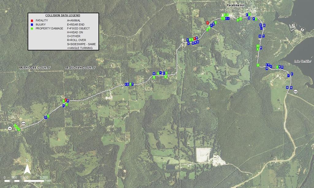
6 Collisions,
7 Constraints Mapping Reconnaissance Performed to Identify Constraints Wetlands and Waters Threatened & Endangered Species Critical Habitat Archeological Sites and Historic Properties Aboveground or Underground Storage Tanks Oil/Gas Wells Residences Commercial Facilities Utilities
8 National Wetlands Inventory
9 Underground and Aboveground Storage Tanks

10 Residences and Commercial Facilities
11 Utilities

12 Unique Properties Note: Cultural Resource properties not shown.

13 Composite Constraints Map

 Establish adequate clear")
14 Proposed Project Typical Section Proposed Improvements Two 12-foot lanes 8-foot paved shoulders 1:4 foreslopes 8-foot wide ditches 1:3 backslopes (maximum) Establish adequate clear recovery area
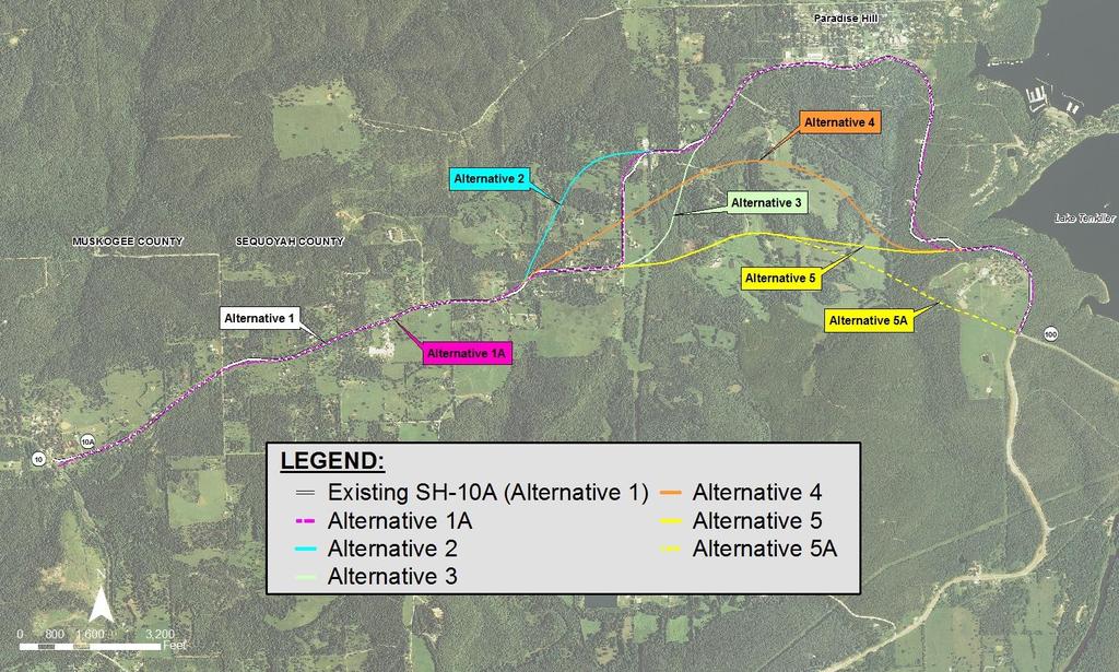
15 Alternatives
16 Alternative 1: On Existing Alignment Goes through Paradise Hill Minimal widening and overlay Improves superelevation where practical (superelevation = banking on curves) Improvements to vertical alignment curves (sag) where practical Does not meet current design standards Does not address/modify substandard horizontal nor majority of substandard vertical curves Slight impacts to Tribal land

17 Alternative 1A: On or Near Existing Alignment Goes through Paradise Hill Improves superelevation Does address substandard horizontal & vertical curves Slight impacts to Tribal land
18 Alternative 2: West Offset Goes through Paradise Hill Offset alignment replaces 8 substandard horizontal curves & 15 substandard vertical curves No impacts to Tribal land
19 Alternative 3: East Offset Goes through Paradise Hill Offset alignment replaces 7 substandard horizontal curves & 12 substandard vertical curves Slight impacts to Tribal land Unfavorable terrain High construction cost

20 Alternative 4: South Offset Offset alignment replaces 25 substandard horizontal curves & 43 substandard vertical curves Does not go through Paradise Hill No impacts to Tribal land Unfavorable terrain High construction cost

21 Alternative 5: Southernmost Offset Offset alignment replaces 22 substandard horizontal curves & 40 substandard vertical curves Does not go through Paradise Hill Slight impacts to Tribal land Unfavorable terrain High construction cost

22 Alternative 5A: Southernmost Offset, Through Connection Does not go through Paradise Hill Meets new construction criteria Offset alignment replaces 25 substandard horizontal curves & 45 substandard vertical curves Bisects United Methodist Boys Ranch Slight impacts to Tribal land Unfavorable terrain High construction cost
23 Alternatives Comparison Purpose & Need: Correct Deficiencies, Improve Safety, Accommodate Traffic On or Near Existing Alignment Offset Alignment Project Component* Alternative 1: On Existing Alternative 1A: On or Near Existing Alternative 2: West Offset Alternative 3: East Offset Alternative 4: South Offset Alternative 5: Southernmost Offset Alternative 5A: Southernmost Offset Through Connection to SH-100 Geometric Design Shoulder Width 2 Paved 8 Paved 8 Paved 8 Paved 8 Paved 8 Paved 8 Paved Design Exceptions Required Numerous Environmental Impacts Cultural Resources None Known None Known None Known <1 Acre Potential Arch. Site <2 Acre Potential Arch. Site None Known None Known Potential AST/UST Impacts 2 Locations 2 Locations 2 Locations 2 Locations 1 Location 1 Location 1 Location Wetlands None None Approx. 0.1 Acre Approx. 0.1 Acre Approx. 0.7 Acre Approx. 0.2 Acre Approx. 0.2 Acre Streams Approx. 400 feet Approx. 500 feet Approx. 1,100 feet Approx. 1,400 feet Approx. 2,000 feet Approx. 1,800 feet Approx. 2,000 feet Right-of-Way Impacts Utility Costs (million) Approx. $1.8 Approx. $1.7 Approx. $1.5 Approx. $1.6 Approx. $1 Approx. $1 Approx. $0.8 Residential Relocations <3 <3 <3 <3 >3 <3 <3 Commercial Impacts Minimal; No Structures Minimal; No Structures Minimal; No Structures Minimal; No Structures Minimal; No Structures Minimal; No Structures Minimal; No Structures US Government Approx. 2 Acre Approx. 3 Acres Approx. 3 Acres Approx. 3 Acres Approx. 1 Acre Approx. 1 Acre None Tribal Property 0.13 Acre 0.10 Acre None Known 0.10 Acre None Known 0.10 Acre 0.10 Acre United Methodist Boys Ranch Approx. 7 Acres Approx. 9 Acres Approx. 9 Acres Approx. 9 Acres Approx. 11 Acres Approx. 11 Acres Approx. 11 Acres Cost Total Cost (million) Approx. $12 Approx. $18 Approx. $18 Approx. $25 Approx. $24 Approx. $26 Approx. $28 Highway Access to Paradise Hill Through Traffic Mobility Constructability Meets Purpose & Need? *All impact estimates are preliminary only and subject to change upon completion of survey and further design.
24 Alternative Analysis Eliminate Alternative 1: only minimal improvements Eliminate Alternatives 4, 5, and 5A: Alignments offset south of Paradise Hill Do not provide highway access to Paradise Hill destinations Alternatives 1A, 2, and 3: Eliminate Alternative 3: most cultural resource impacts and most expensive Alternatives 1A and 2: Essentially same alignment, but Alternative 2 includes a short offset segment Alternative 2 has no known tribal land impacts, is more constructible, and better meets current design criteria than Alternative 1A
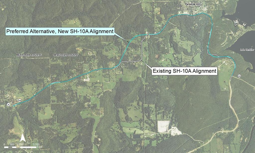
25 Preferred Alternative Alternative 2: West Offset Disadvantage: Some residential impacts Advantages: Highway access to Paradise Hill Good constructability and complies with design criteria No known impacts to cultural resources Comparable wetlands/waters impacts to Alternatives 3, 4, 5, & 5A No Tribal land needed Lower total project cost than Alternatives 3, 4, 5, & 5A Fewer utility conflicts than Alternatives 1, 1A, & 3
26 Preferred Alternative 2: West Offset Goes through Paradise Hill Offset alignment meets new construction criteria Offset segment replaces 8 substandard horizontal curves & 15 substandard vertical curves No impacts to Tribal land
27 Public Participation Program Stakeholder Meeting held October 18, 2016 Stakeholders included Agencies, Elected Officials, and Businesses Received 5 written comments and/or concerns General support of the Preferred Alternative Tonight s Open House Comments due by February 14, 2017 Review all comments Complete design report
28 What Happens Next? Complete design report Complete Environmental Studies, Survey, and Design Plans Public Outreach after Environmental Studies Complete Begin Right-of-Way Acquisition (Year 2019) Begin Utilities Relocation (Year 2019) Begin Construction (Year 2021)
29 Submit Your Comments Leave your written comments with us tonight. By mail: Oklahoma Department of Transportation Environmental Programs Division 200 N. E. 21st Street Oklahoma City, OK By fax: (405) By website: By Please submit your comments by February 14, 2017.
30 Thank you!
WELCOME. State Highway 51A in Blaine County. ODOT Public Meeting
 WELCOME State Highway 51A in Blaine County ODOT Public Meeting July 28, 2015 6:00 P.M. TEAM INTRODUCTIONS ATKINS Daniel Humphrey Design Consultant CC ENVIRONMENTAL Geoff Canty Environmental Consultant
Proposed I-40/Frisco Road Interchange. Canadian County. Public Meeting. June 13, 2017
 Proposed I-40/Frisco Road Interchange Canadian County Public Meeting June 13, 2017 Partnership City of Yukon City of Oklahoma City Oklahoma Department of Transportation Meeting Purpose Purpose and need
WELCOME. Public Meeting for I-35 / I-44 Interchange. October 6, 2015
 WELCOME Public Meeting for I-35 / I-44 Interchange October 6, 2015 TEAM INTRODUCTIONS PURPOSE OF THIS MEETING is to present the alternative alignments for the I-35/I-44 and I-35/NE 63rd Street Interchanges
Public Meeting for SH-85A Horse Creek Bernice, OK. SH-85A bridge located 3.5 miles east of SH-85, including west and east approaches
 WELCOME Public Meeting for SH-85A Horse Creek Bernice, OK SH-85A bridge located 3.5 miles east of SH-85, including west and east approaches Randle White, PE ODOT Division VIII Engineer PURPOSE OF THIS
I-40 in Oklahoma County from MM 167 to MM 173
 I-40 in Oklahoma County from MM 167 to MM 173 From East of Choctaw Road, East to the Pottawatomie County Line March 4, 2014 6:00 p.m. 1 Purpose of Meeting Present purpose and need for the proposed project
GEOMETRIC DESIGN CRITERIA for Non-freeway Resurfacing, Restoration, and Rehabilitation Projects
 GEOMETRIC DESIGN CRITERIA for Non-freeway Resurfacing, Restoration, and Rehabilitation Projects SEPTEMBER 1989 Arkansas State Highway and Transportation Department GEOMETRIC DESIGN CRITERIA for Non-freeway
Public Meeting. SD 37 James River Bridge Beadle County P 0037(140)140 PCN 04FH. Steve Johnson, PE Chief Bridge Design Engineer.
140 PCN 04FH. Steve Johnson, PE Chief Bridge Design Engineer.") Public Meeting SD 37 James River Bridge Beadle County P 0037(140)140 PCN 04FH Steve Johnson, PE Chief Bridge Design Engineer August 9, 2016 Purpose of the Meeting Provide a Project Overview Background
Public Meeting SD 37 James River Bridge Beadle County P 0037(140)140 PCN 04FH Steve Johnson, PE Chief Bridge Design Engineer August 9, 2016 Purpose of the Meeting Provide a Project Overview Background
CHAPTER 3 SCOPE SUMMARY
 CHAPTER 3 SCOPE SUMMARY GENERAL The SDDOT is an active member of AASHTO to share common national design standards for the state highway system. The AASHTO Task Force on Geometric Design has completed the
Information for File # RJH
 Information for File #2011-01629-RJH Applicant: Matthew Ternes Corps Contact: Ryan Huber, U. S. Army Corps of Engineers, 211 North Broadway, Suite 221, Green Bay, Wisconsin 54303; ryan.j.huber@usace.army.mil;
Public Meeting. US Highways 18 & 281 and SD Highway 50 From Douglas County Line to SD46 Charles Mix County
 Public Meeting US Highways 18 & 281 and SD Highway 50 From Douglas County Line to SD46 Charles Mix County Cary Cleland Road Design Engineering Supervisor January 17, 2017 Project Limits US18/US281 US281
Oklahoma Department of Transportation Environmental Programs Division Office Fax
 Oklahoma Department of Transportation Environmental Programs Division Office 521-3050 Fax 522-5193 Documented Categorical Exclusion (DCE) for I-40: Pavement Reconstruction and Added Lanes from the Douglas
Chapter 1. General Design Information. Section 1.02 Structure Selection and Geometry. Introduction
 Chapter 1 Bridge Design Manual General Design Information Section 1.02 Selection and Geometry Introduction Selection or Rehabilitation Report This section of the design manual provides guidance on the
LOCATION AND DESIGN DIVISION
 VIRGINIA DEPARTMENT OF TRANSPORTATION LOCATION AND DESIGN DIVISION INSTRUCTIONAL AND INFORMATIONAL MEMORANDUM GENERAL SUBJECT: Design Exceptions / Waivers SPECIFIC SUBJECT: Design Exception Request Form
GREENE TOWNSHIP Pike County, Pennsylvania SPEED LIMIT STUDY T-370, T-372 & T-378
 GREENE TOWNSHIP Pike County, Pennsylvania SPEED LIMIT STUDY T-370, T-372 & T-378 Greene Township Board of Supervisors 100 Fourth Street, Honesdale, PA 18431 570-251-9550 FAX 251-9551 www.shepstone.net
SAN ANTONIO STREET BRIDGE AT COMAL RIVER. Open House
 SAN ANTONIO STREET BRIDGE AT COMAL RIVER Open House May 1, 2018 SAN ANTONIO STREET BRIDGE AT COMAL RIVER, NEW BRAUNFELS COMAL COUNTY OPEN HOUSE MAY 1, 2018 5:00 P.M 7:00 P.M. New Braunfels Civic/Convention
Appendix B. Benefit-Cost Technical Memorandum
 Appendix B Benefit-Cost Technical Memorandum This Page Left Blank Intentionally MEMORANDUM TO: FROM: Michael Kalnbach MnDOT District 1 Project Manager Graham Johnson, PE DATE: September 2, 2014 RE: TH
Chapter DESIGN EXCEPTION PROCESS
 Chapter 14 DESIGN EXCEPTION PROCESS 14.1 GENERAL The information in this section describes the design exception process for planning studies and project development projects. In addition, this section
TRAFFIC SAFETY EVALUATION. Using the Highway Safety Manual and the Interactive Highway Safety Design Model. I 15 Dry Lakes Design Exception
 TRAFFIC SAFETY EVALUATION Using the Highway Safety Manual and the Interactive Highway Safety Design Model I 15 Dry Lakes Design Exception Prepared for: Nevada Department of Transportation Safety Engineering
U S H I G H W A Y 1 4 F I N A L E N V I R O N M E N T A L I M P A C T S T A T E M E N T ( F E I S
 U S H I G H W A Y 1 4 F I N A L E N V I R O N M E N T A L I M P A C T S T A T E M E N T ( F E I S ) N E W U L M T O N O R T H M A N K A T O, M I N N E S O T A Summary What is the US 14 Final EIS? An Environmental
WELCOME IL 47. Community Advisory Group Meeting #5 Waubonsee Community College Wednesday, May 31, 2017
 WELCOME IL 47 Community Advisory Group Meeting #5 Waubonsee Community College Wednesday, May 31, 2017 MEETING PURPOSE MEETING AGENDA 1. Welcome/Introduction 2. Review Previous Public Involvement 3. Process/Schedule
175 th Street Quivira to Antioch (TH-1343) Preliminary Engineering Study Overland Park, KS
 Preliminary Engineering Study Overland Park, KS") 175 th Street Quivira to Antioch (TH-1343) Preliminary Engineering Study Overland Park, KS June 2012 Prepared by: Public Works Department City of Overland Park, KS EXECUTIVE SUMMARY... 2 INTRODUCTION...
175 th Street Quivira to Antioch (TH-1343) Preliminary Engineering Study Overland Park, KS June 2012 Prepared by: Public Works Department City of Overland Park, KS EXECUTIVE SUMMARY... 2 INTRODUCTION...
Public Meeting. US Highway 81 From 306 th St. to 303 rd St. & 300 th St. Yankton County NH 0081(103)6 PCN 04G5. Brandon Riss, PE Road Design Engineer
6 PCN 04G5. Brandon Riss, PE Road Design Engineer") Public Meeting US Highway 81 From 306 th St. to 303 rd St. & 300 th St. Yankton County NH 0081(103)6 PCN 04G5 Brandon Riss, PE Road Design Engineer October 11, 2018 Purpose of the Meeting Involve the Public
Public Meeting US Highway 81 From 306 th St. to 303 rd St. & 300 th St. Yankton County NH 0081(103)6 PCN 04G5 Brandon Riss, PE Road Design Engineer October 11, 2018 Purpose of the Meeting Involve the Public
Information for File # MVP SJW
 Information for File # MVP-2015-00132-SJW Applicant: Eau Claire County Highway Department Corps Contact: Samuel Woboril Address: 1314 Contractors Blvd, Plover, Wisconsin 54467 E-Mail: samuel.j.woboril@usace.army.mil
CHAPTER 18 TEMPORARY ROADS AND BRIDGES
 Change #1 - Revised 12/12 CHAPTER 18 TEMPORARY ROADS AND BRIDGES 18.0 INTRODUCTION These guidelines are to be used to design temporary roads and bridges where traffic will be maintained at the construction
603 - ASPHALT PAVEMENT SMOOTHNESS SECTION 603 ASPHALT PAVEMENT SMOOTHNESS
 SECTION 603 ASPHALT PAVEMENT SMOOTHNESS 603.1 DESCRIPTION Determine the smoothness of the pavement surface and correct the deficiencies as specified in the Contract Documents. For the purposes of this
TABLE OF CONTENTS. Manual Section. Introduction 1. Using This Manual 2-3. Administrative Actions 4-6. Road and Bridge Project Types 7
 ii TABLE OF CONTENTS Manual Section Pages Introduction 1 Using This Manual 2-3 Administrative Actions 4-6 Road and Bridge Project Types 7 Road and Bridge Funding Programs 8-9 Project Planning and Eligible
CUYAHOGA COUNTY DEPARTMENT OF PUBLIC WORKS CUYAHOGA COUNTY ENGINEER TOWNSHIP SUBDIVISION STREET DESIGN STANDARDS AND IMPROVEMENT PLAN REQUIREMENTS
 CUYAHOGA COUNTY DEPARTMENT OF PUBLIC WORKS CUYAHOGA COUNTY ENGINEER TOWNSHIP SUBDIVISION STREET DESIGN STANDARDS AND IMPROVEMENT PLAN REQUIREMENTS November 25, 2013 Table of Contents Cuyahoga County Engineer's
M D 355 [FR E D E R IC K R O A D] OVER
![M D 355 [FR E D E R IC K R O A D] OVER](/thumbs/79/79553721.jpg "M D 355 [FR E D E R IC K R O A D] OVER") M D 355 [FR E D E R IC K R O A D] OVER LITTLE BENNETT CREEK MAINTENANCE OF TRAFFIC ALTERNATIVE ANA LYSIS Prepared by: INTRODUCTION The purpose of this report is to present the results of traffic analyses
M D 355 [FR E D E R IC K R O A D] OVER LITTLE BENNETT CREEK MAINTENANCE OF TRAFFIC ALTERNATIVE ANA LYSIS Prepared by: INTRODUCTION The purpose of this report is to present the results of traffic analyses
PERFORMANCE BASED PRACTICAL DESIGN
 PERFORMANCE BASED PRACTICAL DESIGN DOT S FACE INCREASING CHALLENGES ENGINEERING CULTURE We learned from those who taught us how and why we follow the standards There are valid reasons that tell us we now
Lubbock Outer Route Feasibility Study Report Executive Summary
 Lubbock Outer Route Feasibility Study Report Executive Summary Prepared for: Texas Department of Transportation Lubbock District Prepared by: MACTEC Engineering and Consulting, Inc. 6701 Aberdeen, Suite
Engineering Design Services for Safety Improvements along CR 476 from the Hernando County Line to US 301 (SR 35) Sumter County, Florida
 Sumter County, Florida") Engineering Design Services for Safety Improvements along CR 476 from the Hernando County Line to US 301 (SR 35) Sumter County, Florida November 7, 2014 SUBMITTED BY: Dewberry Bowyer-Singleton 520 South
Engineering Design Services for Safety Improvements along CR 476 from the Hernando County Line to US 301 (SR 35) Sumter County, Florida November 7, 2014 SUBMITTED BY: Dewberry Bowyer-Singleton 520 South
Chester Bridge Environmental Assessment (EA) CAG Meeting #2. October 12, 2017
 CAG Meeting #2. October 12, 2017") Chester Bridge Environmental Assessment (EA) CAG Meeting #2 October 12, 2017 Agenda Introductions Purpose & Need review and Merger Approval Review of the Conceptual Alternatives Recap of the Public Meeting
Chester Bridge Environmental Assessment (EA) CAG Meeting #2 October 12, 2017 Agenda Introductions Purpose & Need review and Merger Approval Review of the Conceptual Alternatives Recap of the Public Meeting
100 Design Controls and Exceptions
 100 Design Controls and Exceptions Table of Contents 100 Introduction... 1 101 Functional Classification... 1 101.1 General... 1 101.2 Urban & Rural... 1 101.3 Classification Used In ODOT Design Criteria...
Upgrading Rail Lines for Higher Speeds
 Upgrading Rail Lines for Higher Speeds Railroad Infrastructure Diagnosis and Prognosis David E. Staplin, PE University of Nevada Las Vegas, October 16, 2018 Upgrading Rail Lines for Higher Speeds A Perspective
WOO-SR Feasibility Study (PID 90541) Feasibility Study Report April 22, 2011
 Feasibility Study Report April 22, 2011") TABLE OF CONTENTS EXECUTIVE SUMMARY... 1 CHAPTER 1: INTRODUCTION... 5 1.1 Study Purpose and background... 5 1.2 Study Approach... 6 1.3 Study Area... 6 CHAPTER 2: DESCRIPTIONS OF ALTERNATIVES... 7 2.1
TABLE OF CONTENTS EXECUTIVE SUMMARY... 1 CHAPTER 1: INTRODUCTION... 5 1.1 Study Purpose and background... 5 1.2 Study Approach... 6 1.3 Study Area... 6 CHAPTER 2: DESCRIPTIONS OF ALTERNATIVES... 7 2.1
Information for File # BGO
 Information for File #2016-00137-BGO Applicant: Dovre Township Corps Contact: Benjamin Orne Address: 180 Fifth Street East, Suite 700, St. Paul, Minnesota 55101-1678 E-Mail: benjamin.g.orne@usace.army.mil
On behalf of the Carolina Crossroads project team we thank you for taking the time to attend this meeting.
 On behalf of the Carolina Crossroads project team we thank you for taking the time to attend this meeting. Located in the heart of South Carolina, the I-20/26/126 Corridor is the crossroads of the state
EXISTING ROADWAY CONDITION ASSESSMENT REPORT (ERCAR) SAMPLE OUTLINE
 SAMPLE OUTLINE") EXISTING ROADWAY CONDITION ASSESSMENT REPORT (ERCAR) SAMPLE OUTLINE The Existing Roadway Condition Assessment Report (ERCAR) should include the evaluation of all elements against new construction criteria.
EXISTING ROADWAY CONDITION ASSESSMENT REPORT (ERCAR) SAMPLE OUTLINE The Existing Roadway Condition Assessment Report (ERCAR) should include the evaluation of all elements against new construction criteria.
Larimer County Land Use Code Section 5.8: Rural Land Use Process
 Larimer County Land Use Code Section 5.8: Rural Land Use Process 5.8.6 PRINCIPLES D. Development Standards 3. Engineering Standards and Guidelines for Roads and Drainage The following Standards and Guidelines
Project Information. Pursuant to Section 404 of the Clean Water Act (33 U.S. Code 1344), notice is hereby given that
, notice is hereby given that") US ARMY Corps Of Engineers Little Rock District JOINT PUBLIC NOTICE CORPS OF ENGINEERS STATE OF ARKANSAS Application Number: 2014-00083-1 Date: December 22, 2014 Comments Due: January 16, 2015 TO WHOM
US ARMY Corps Of Engineers Little Rock District JOINT PUBLIC NOTICE CORPS OF ENGINEERS STATE OF ARKANSAS Application Number: 2014-00083-1 Date: December 22, 2014 Comments Due: January 16, 2015 TO WHOM
Ports to Plains Feasibility Study
 Executive Summary Ports to Plains Feasibility Study June 2001 Prepared For Texas Department of Transportation Oklahoma Department of Transportation New Mexico Highway and Transportation Department Colorado
CLA /10.54, PID Project Description:
 Project Description: The proposed project will consist of widening IR 70 to three lanes from Enon Road (SLM 06.75) to the US 68 interchange ramps (SLM 10.55). IR 70 is a component of the Strategic Highway
Table 1 Sterling Highway MP 45 to 60 Facts Summary
 Table 1 Sterling Highway MP 45 to 60 Facts Summary Purpose and Need Criteria Sterling Highway MP 45 to 60 Alternatives PURPOSE AND NEED CRITERIA Capacity & Demand Highway Characteristics Percent of Alternative
Interchange Workshop Report (August 2004)
") U.S. Highway 14 Corridor Study New Ulm to North Mankato Table of Contents Section Interchange Workshop Report (August 2004) Page 1. Introduction and Next Steps 1 2. Interchange Workshop Participants &
U.S. Highway 14 Corridor Study New Ulm to North Mankato Table of Contents Section Interchange Workshop Report (August 2004) Page 1. Introduction and Next Steps 1 2. Interchange Workshop Participants &
SUPPLEMENTAL DRAFT ENVIRONMENTAL IMPACT STATEMENT NORTH BELT FREEWAY SUMMARY INTRODUCTION
 SUMMARY INTRODUCTION The Arkansas State Highway and Transportation Department (AHTD), in cooperation with the Federal Highway Administration (FHWA), is proposing a highway project located in northern Pulaski
OKLAHOMA DEPARTMENT OF TRANSPORTATION SPECIAL PROVISION FOR PAVEMENT AND BRIDGE DECK SMOOTHNESS
 430-2QA(a-i) 09 OKLAHOMA DEPARTMENT OF TRANSPORTATION SPECIAL PROVISION FOR PAVEMENT AND BRIDGE DECK SMOOTHNESS These Special Provisions amend and where in conflict, supersede applicable sections of the
Town of Whitchurch-Stouffville Bethesda Side Road Reconstruction
 Town of Whitchurch-Stouffville Bethesda Side Road Reconstruction Date: Wednesday, April 26, 2017 Time: 3:00 pm to 5:00 pm and 7:00 pm to 8:00 pm 1 Your input is appreciated. You are encouraged to review
THE COMMONWEALTH OF MASSACHUSETTS NON-NHS BRIDGE R&R POLICY
 THE COMMONWEALTH OF MASSACHUSETTS Number: P-92-010 Date: 10-08-92 - ) HIGHWAY DEPARTMENT FROM: NON-NHS BRIDGE R&R POLICY The purpose of this Engineering Directive is to formally notify Department Personnel
Public Notice of Application for Permit
 US Army Corps of Engineers Alaska District ANCHORAGE Regulatory Division (1145) CEPOA-RD Post Office Box 6898 JBER, Alaska 99506-0898 Public Notice of Application for Permit PUBLIC NOTICE DATE: June 11,
DRAFT. SR-60 7 th Avenue Intersection Control Evaluation (ICE) I-605 Corridor Improvement Project (CIP) I-605/SR-60 EA# 3101U0
 I-605 Corridor Improvement Project (CIP) I-605/SR-60 EA# 3101U0") SR-60 7 th Avenue Intersection Control Evaluation (ICE) I-605/SR-60 EA# 3101U0 October 9, 2017 Contents 1 Purpose of ICE Memo... 1 2 Background... 1 3 Existing Interchange Deficiencies... 1 4 Context Sensitive
SR-60 7 th Avenue Intersection Control Evaluation (ICE) I-605/SR-60 EA# 3101U0 October 9, 2017 Contents 1 Purpose of ICE Memo... 1 2 Background... 1 3 Existing Interchange Deficiencies... 1 4 Context Sensitive
Chapter URBAN & RURAL FREEWAY DESIGN
 Chapter 5 URBAN & RURAL FREEWAY DESIGN 5.1 INTRODUCTION This chapter provides standards and guidance for urban and rural freeways on new construction/reconstruction projects. The chapter also provides
Warren Wagon Road Improvement Project McCall Ranger District, Payette National Forest Project Description
 Warren Wagon Road Improvement Project McCall Ranger District, Payette National Forest Project Description Introduction The analysis of the Warren Wagon Road Improvement Project is tiered to the 2003 Environmental
FASTLANE Grant Project US-69 through Calera. Oklahoma Traffic Engineering Association 2017 Fall Meeting
 FASTLANE Grant Project US-69 through Calera Oklahoma Traffic Engineering Association 2017 Fall Meeting October 17, 2017 US-69 through Calera Project Location Town of Calera City of Durant Project Location
Rehabilitation of Highway Pavements an Engineering Challenge
 Rehabilitation of Highway Pavements an Engineering Challenge G eorge W. M ca lpin Transportation Consultant Rye, New Hampshire IN T R O D U C T IO N There is no question that our country is currently confronted
ARKANSAS STATE HIGHWAY AND TRANSPORTATION DEPARTMENT
 ARKANSAS STATE HIGHWAY AND TRANSPORTATION DEPARTMENT Dan Flowers Director Phone (501) 569-2000 Fax (501) 569-2400 P.O. Box 2261 Little Rock, Arkansas 72203-2261 WWW.ARKANSASHIGHWAYS.COM September 22, 2008
Standard Performance Attributes for Transportation Projects
 Standard s for Transportation Projects Mainline Operations Local Operations Maintainability Construction Impacts Environmental Impacts Project Schedule An assessment of traffic operations and safety on
Table of Contents TOC. General Information. Street Classifications. Geometric Design Criteria
 Design Manual Chapter 5 - Roadway Design Table of Contents TOC Table of Contents Chapter 5 - Roadway Design 5A General Information 5A-1---------------------------------General Information A. Concept.....
TH 25 Bituminous Mill, Full Depth Reclamation and Overlay SP &
 TH 25 Bituminous Mill, Full Depth Reclamation and Overlay SP 4910-29 & 0504-14 Contract No. 1002252 Project Overview is in need of professional and technical assistance to provide detail design for State
500 Interchange Design
 500 Interchange Design Table of Contents 501 Interchange Design... 5-1 July 2015 501.1 General... 5-1 501.2 Interchange Type... 5-1 501.2.1 General... 5-1 502 Interchange Design Considerations... 5-2 502.1
b. Include an evaluation of maintenance of traffic for ramps, local roads and cross streets.
 630-5 Maintenance of Traffic Alternative Analysis As noted in Section 630-1, Section 1400 of the L&D Manual indicates that a Maintenance of Traffic Alternative Analysis will be performed. This analysis
LOOP 9 SOUTHEAST WELCOME TO THE LOOP 9 CORRIDOR/FEASIBILITY STUDY. Presentation 6:30 p.m. to 7:00 p.m.
 1 WELCOME TO THE LOOP 9 CORRIDOR/FEASIBILITY STUDY PUBLIC MEETINGS Open House 5:30 p.m. to 6:30 p.m. Presentation 6:30 p.m. to 7:00 p.m. Open House 7:00 p.m. to 8:00 p.m. Tuesday, September 24, 2013 Thursday,
I-10 KENDALL EXTENSION. Open House
 I-10 KENDALL EXTENSION Open House The environmental review, consultation, and other actions required by applicable Federal environmental laws for this project are being, or have been, carried-out by TxDOT
SUMMARY S.1 PROJECT DESCRIPTION AND LOCATION S.2 PURPOSE AND NEED
 S SUMMARY S.1 PROJECT DESCRIPTION AND LOCATION The Virginia Department of Transportation (VDOT), in cooperation with the Federal Highway Administration (FHWA), is studying alternatives to meet transportation
ARKANSAS DEPARTMENT OF TRANSPORTATION INTER OFFICE MEMORANDUM
 ARKANSAS DEPARTMENT OF TRANSPORTATION INTER OFFICE MEMORANDUM September 15, 2017 TO: Master Files FROM: John Fleming, Division Head, Environmental Division SUBJECT: Job Number 110643 FAP Number NHPP-0054(23)
Conclusions & Lessons Learned
 What is a DDI Recommended Practices Traffic Operations Analysis Geometric Design FHWA Review Conclusions & Lessons Learned It s not about you, it s about the public Developed by Access Utah County
Office of the Secretary PO Box Baton Rouge, LA ph: fx: October 2, 2014
 Office of the Secretary PO Box 94245 Baton Rouge, LA 70804-9245 ph: 225-379-1200 fx: 225-379-1851 Bobby Jindal, Governor Sherri H. LeBas, P.E., Secretary October 2, 2014 Ms. Marty Vitale AASHTO Special
DIVISION I TRAFFIC IMPACT STUDY GUIDELINES ENGINEERING STANDARDS
 CITY OF ALBANY DEPARTMENT OF PUBLIC WORKS DIVISION I TRAFFIC IMPACT STUDY GUIDELINES ENGINEERING STANDARDS Prepared By PUBLIC WORKS DEPARTMENT ALBANY, OREGON 97321 Telephone: (541) 917-7676 TABLE OF CONTENTS
PUBLIC HEARING LOOP 9
 PUBLIC HEARING LOOP 9 From Interstate (I)-35E to I-45 Dallas and Ellis Counties, Texas CSJ: Loop 2964-10-005 9: I-35E to I-45 Tuesday, June 20, 20, 2017 2017 Public Hearing Introductions ELECTED & PUBLIC
Airport Road from 1 km North of Mayfield Road to 0.6 km North of King Street Public Information Centre #1
 Municipal Class Environmental Assessment Airport Road from 1 km North of Mayfield Road to 0.6 km North of King Street Public Information Centre #1 Date: Thursday, June 20, 2013 Time: 6:30 p.m. 8:30 p.m.
EXISTING ROADWAY CONDITION ASSESSMENT REPORT (ERCAR) SAMPLE OUTLINE
 SAMPLE OUTLINE") EXISTING ROADWAY CONDITION ASSESSMENT REPORT (ERCAR) SAMPLE OUTLINE The Existing Roadway Condition Assessment Report (ERCAR) should include the evaluation of all elements against new construction criteria.
EXISTING ROADWAY CONDITION ASSESSMENT REPORT (ERCAR) SAMPLE OUTLINE The Existing Roadway Condition Assessment Report (ERCAR) should include the evaluation of all elements against new construction criteria.
6 th STREET VIADUCT SIESMIC IMPROVEMENT PROJECT
 6 th STREET VIADUCT SIESMIC IMPROVEMENT PROJECT Project Location The 6 th Street Viaduct (Bridge No. 53C-1880) and Sixth Street Overcrossing (Bridge No. 53-0595) comprise a single structure, which spans
Exit 73 I-29 Interchange Modification Justification Study
 xit 73 I-29 Interchange Modification Justification tudy Introduction Figure 1 shows the location of xit 73. This interchange is proposed to be the connecting point of the ast and West Corridors to I-29.
APPENDIX C INLETS. The application and types of storm drainage inlets are presented in detail in this Appendix.
 Storm Drainage 13-C-1 APPENDIX C INLETS 1.0 Introduction The application and types of storm drainage inlets are presented in detail in this Appendix. 2.0 Inlet Locations Inlets are required at locations
5.0 Plan Development. 5.1 Introduction. 5.2 Design References
 5.0 Plan Development 5.1 Introduction The plan development section of this manual is intended to assist the LPA and the designer through the preliminary engineering phase of project development. Information
DESIGN BULLETIN #72/2010 (Revised September 2017) Design Exception Request Process
 Design Exception Request Process") DESIGN BULLETIN #72/2010 (Revised September 2017) Design Exception Request Process SUPERSEDED IN JANUARY 2018 BY THE DESIGN EXCEPTIONS GUIDELINE: http://www.transportation.alberta.ca/6137.htm Background
DESIGN BULLETIN #72/2010 (Revised September 2017) Design Exception Request Process SUPERSEDED IN JANUARY 2018 BY THE DESIGN EXCEPTIONS GUIDELINE: http://www.transportation.alberta.ca/6137.htm Background
500 Interchange Design
 500 Interchange Design Table of Contents 501 Interchange Design... 1 501.1 General... 1 501.2 Interchange Type... 1 501.2.1 General... 1 502 Interchange Design Considerations... 2 502.1 Determination of
I-69 Angelina and Nacogdoches Counties Scoping Study Executive Summary
 I-69 Angelina and Nacogdoches Counties Scoping Study Executive Summary November 2013 The Texas Department of Transportation (TxDOT) is working to find the most appropriate means to develop the Interstate
Northwest State Route 138 Corridor Improvement Project
 Northwest State Route 138 Corridor Improvement Project Los Angeles County, CA DISTRICT 7- LA- 138 (PM 0.0/36.8); DISTRICT 7- LA- 05 (PM 79.5/83.1); DISTRICT 7- LA- 14 (PM 73.4/74.4) 265100/ 0700001816
U.S. 287 Relocation Study
 U.S. 287 Relocation Study Northern Colorado Water Conservancy District Prepared by: Muller Engineering Company, Inc. Consulting Engineers Table of Contents Appendices...1 List of Tables...2 List of Figures...2
Rapid City, SD HDR Project No RE: Replacement of Existing I-190 Twin Bridges at I-190/Silver Street Interchange, Rapid City, SD
 To: Steve Gramm, SDDOT Memo From: HDR Project: SDDOT I-190 Silver Street Interchange Study Rapid City, SD HDR Project No. 000000000137390 Date: December 27, 2011 RE: Replacement of Existing I-190 Twin
TABLE OF CONTENTS 3.0 AFFECTED ENVIRONMENT AND ENVIRONMENTAL CONSEQUENCES
 TABLE OF CONTENTS 1.0 PURPOSE AND NEED -------------------------------------------------------------------------------------------- 1-1 1.1 STUDY AREA -----------------------------------------------------------------------------------------------------
Community Advisory Committee Meeting No. 2. June 22, 2006
 Community Advisory Committee Meeting No. 2 June 22, 2006 Introductions The Study Team KDOT Wichita Partners Consultants CAC members Overview Today s Agenda Opinion Survey Study Status Starting Concept
MARTINSVILLE SOUTHERN CONNECTOR STUDY CITIZEN INFORMATION MEETING Magna Vista High School 701 Magna Vista School Road Ridgeway, Virginia May 8,
 MARTINSVILLE SOUTHERN CONNECTOR STUDY CITIZEN INFORMATION MEETING Magna Vista High School 701 Magna Vista School Road Ridgeway, Virginia 24148 May 8, 2018 MEETING OVERVIEW AND OBJECTIVES Introduce study
Summary. Preliminary Alternative Development and Screening. DEIS July 23, 2018
 What is the Carolina Crossroads Project? The South Carolina Department of Transportation (SCDOT), in cooperation with the Federal Highway Administration (FHWA), is proposing to upgrade and redesign a key
2003 PRELIMINARY ENGINEERING STUDY JUNE 2006
 167 TH STREET PFLUMM ROAD TO METCALF AVENUE 159 th STREET & PFLUMM ROAD INTERSECTION PFLUMM ROAD 159 TH STREET TO 175 TH STREET QUIVIRA ROAD 159 TH STREET TO 167 TH STREET SWITZER ROAD 159 TH STREET TO
Welcome. Public Meeting. August 2, :00 to 7:00 p.m. Presentation 6:00 to 6:30 p.m.
 Welcome Public Meeting August 2, 2017 5:00 to 7:00 p.m. Presentation 6:00 to 6:30 p.m. www.glenwoodsouthbridge.net Welcome to the South Bridge Environmental Assessment Public Meeting Why Are We Here Tonight?
I-35/I-80/Iowa 141 Interchange IJR and NEPA A Practical Approach to Resolving a Decades-Old Traffic Operations Challenge
 I-35/I-80/Iowa 141 Interchange IJR and NEPA A Practical Approach to Resolving a Decades-Old Traffic Operations Challenge Client: AJR or IJR? This is a TO-MAY-TO This is a TO-MAH-TO Practical Design PRACTICAL
Arterial Connector Study Adoption Considerations
 Arterial Connector Study Adoption Considerations 1. The Problem/Opportunity. Dakota County, MnDOT and the cities of Inver Grove Heights and Rosemount have conducted this study because Dakota County is
ENCROACHMENT PERMIT APPLICATION INSTRUCTIONS
 ENCROACHMENT PERMIT APPLICATION INSTRUCTIONS Section 1 Applicant and Location Information The first section of the encroachment permit application is used to collect basic information about the applicant
vi Figures viii Summary S.1
 Contents Contents iii Tables vi Figures viii Summary S.1 Chapter 1: Purpose and Need Project History A.1 Project Description A.2 Project Purpose A.5 Transportation Need A.6 Highway Capacity and Congestion
Township of McNab/Braeside Reconstruction/Rehabilitation of Goshen Road
 Township of McNab/Braeside Reconstruction/Rehabilitation of Goshen Road Prepared for: Mr. Ryan Frew, P. Eng. Township of McNab/Braeside 2508 Russett Drive Arnprior, ON K7S 3G8 Prepared by: McIntosh Perry
US 69 RELIEF ROUTE STUDY
 US 69 RELIEF ROUTE STUDY Jacksonville, Texas PUBLIC MEETING #3 August28 th 2018 1 Welcome to the final public meeting for the US 69 Relief Route Study in Jacksonville. This presentation will give a recap
Engineering Assessment Process: Keys to a Solid Engineer s Report
 Engineering Assessment Process: Keys to a Solid Engineer s Report 89th Annual Purdue Road School March 26, 2003 Brad Steckler, P.E. Brad L. Steckler, P.E. Manager of Engineering Assessment Indiana Department
5/11/2016 SR 15 SECTION 088 CSVT SOUTHERN SECTION SR 15 SECTION 088 CSVT SOUTHERN SECTION AGENDA
 PUBLIC OFFICIALS MEETING MAY 11, 2016 AGENDA I. INTRODUCTIONS V. CURRENT PROJECT STATUS VI. PROJECT SCHEDULE VII. UPCOMING ACTIVITIES VOPEN DISCUSSION & QUESTIONS IX. ACTION ITEMS 1 A. Bridge Lighting
CMNAA. Central Manatee Network Alternatives Analysis Alternatives Public Meeting CMNAA STUDY PROCESS. STUDY AREA 17th St. W
 District One CMNAA Central Manatee Network Alternatives Analysis December 12, 2017 5:00 pm - 7:00 pm First Baptist Church 1306 Manatee Ave. W, Bradenton, FL 34205 Central Manatee Network Alternatives Analysis
SECTION 6. ROAD CONSTRUCTION STANDARDS
 SECTION 6. ROAD CONSTRUCTION STANDARDS Construction of new roads or reconstruction of existing roads proposed for dedication to the County shall conform to the standards set forth in this section. Roads
City of San Juan Capistrano PROJECT UPDATE ORTEGA HIGHWAY (SR-74) CITY- SEGMENT WIDENING PROJECT (CIP 14107) December 15, 2015 FOR THE
 CITY- SEGMENT WIDENING PROJECT (CIP 14107) December 15, 2015 FOR THE") City of San Juan Capistrano PROJECT UPDATE FOR THE ORTEGA HIGHWAY (SR-74) CITY- SEGMENT WIDENING PROJECT (CIP 14107) CITY COUNCIL MEETING 1 TONIGHT S RECOMMENDATIONS Receive and file a project update presentation.
City of San Juan Capistrano PROJECT UPDATE FOR THE ORTEGA HIGHWAY (SR-74) CITY- SEGMENT WIDENING PROJECT (CIP 14107) CITY COUNCIL MEETING 1 TONIGHT S RECOMMENDATIONS Receive and file a project update presentation.
TABLE OF CONTENTS. 3.0 ALTERNATIVES CSAH 14 Reconstruction Alternatives Regional Access Scenario Alternatives...
 TABLE OF CONTENTS 1.0 PURPOSE OF STUDY... 1 1.1 Project Need... 1 1.2 Availability of Federal Funding... 1 1.3 Need for Understanding Regional System Issues... 1 1.4 Goals for Phase I Study and Subsequent
Chapter 5. Utilities
 Chapter 5 Utilities 5.1 General...5-1 5.2 Utility Accommodation Manual...5-2 5.3 Location of Existing Utilities...5-3 5.3.1 Quality Levels of Utility Locates...5-3 5.4 Subsurface Utility Engineering...5-5
HISTORIC PROPERTY SURVEY REPORT
 1. UNDERTAKING DESCRIPTION AND LOCATION District County Route Post Miles Unit E-FIS Project Number Phase District Federal Project. Number. County (Prefix, Agency Code, Project No.) Location 04 SC BRLO-5937(124)