Chapter 4: Alternatives Analysis
|
|
|
- Georgia Henderson
- 6 years ago
- Views:
Transcription
1 Chapter 4: Alternatives Analysis 4.0 Introduction and Alternatives Analysis Process Detailed analysis and evaluation of the alternatives was a critical step in the development of comprehensive and workable solutions to the problems identified in Chapter 2. As discussed in Chapter 3: Alternatives Development, a wide variety of alternatives were developed that included both long and short-term solutions. The alternatives were initially developed to address existing deficiencies, by improving traffic flow and safety, and also with the intent of minimizing property and environmental impacts. Working closely with the Study Advisory Committee (SAC), this list of alternatives was narrowed to four long-term alternatives and a number of short-term improvements. During the next part of the study process, each of the build alternatives was analyzed in more detail using the evaluation criteria described in Chapter 1 of this report. This includes potential improvements in traffic operations and safety, the potential effects on the natural, socioeconomic and cultural environments, and estimated construction costs. The intent of this step is to compare the expected benefits and impacts of each of the alternatives. The results of this analysis were compiled in an evaluation matrix and presented to the SAC. Working with the SAC, the long-term alternatives were narrowed to two and the short-term improvements were consolidated to three packages. The two long-term alternatives recommended by the SAC and MassHighway personnel and selected by the Study Team are Alternative 2B and Alternative 3A. The following presents a detailed description of the results of the alternatives analysis for the short term alternatives, all four long-term alternatives, as well as transit, park and ride and Intelligent Transportation Systems (ITS) options. 4.1 Mobility Analysis Traffic Operations Interstate/Interchange Mobility An analysis was conducted for each alternative of the Route 110/113 interchange ramps at I-93. The analyses were conducted in accordance with the procedures contained in the Highway Capacity Manual 2000 (Transportation Research Board). The Highway Capacity Software (version 5.2), which implements the HCM procedures, was used to perform the analyses. The term Level of Service () is used to denote the operating conditions of the merge and diverge areas at ramp junctions with the mainline at an interchange. For ramp analyses, the is defined in terms of density, which is measured as the number of passenger cars per mile per lane. The at ramp junction areas is also divided into a range of six letter grades, ranging from A to F, with A being the best and F the worst. F exists when the demand exceeds the capacity of upstream or downstream freeway sections, or when the demand exceeds the capacity of an off-ramp. The results of the ramp analyses are show in Figure 4-1 and indicate the following for the longterm alternatives: 4-1
2 The northbound off-ramp would continue to operate with similar conditions as the No- Build condition, B during the AM peak hour and a F during the PM peak hour for each alternative. The northbound on-ramp would continue to operate with similar conditions as the No- Build condition during the AM peak hour at B for each alternative. Operations would decline slightly from a B under the No-Build condition to a C during the PM peak hour for alternatives 2A, 2B, and 3B, while it would continue to operate at B under alternative 3A. This decline on the northbound on-ramp for 2A, 2B, and 3B would be primarily due to minor changes in expected vehicle trip distribution assumed by the modeling software. It should be noted that C is still considered an acceptable condition. The southbound off-ramp would improve from a D under the No-Build condition to a C during the AM peak hour for each alternative. During the PM peak hour, operations would continue to operate as the No-Build condition at C for each alternative. The southbound on-ramp would significantly improve from the No-Build condition for each alternative. During the AM peak hour, the for alternatives 2A and 2B would operate at B and C for alternatives 3A and 3B compared to a F under the No-Build condition. During the PM peak hour, the for alternatives 2A and 2B would operate at A and C for alternatives 3A and 3B compared to D under the No-Build condition. Table 4-1: Ramp Merge and Diverge Summary Future No-Build and Alternatives No-Build Alternative 2A Alternative 2B Alternative 3A Alternative 3B AM Peak Hour PM Peak Hour AM Peak Hour PM Peak Hour AM Peak Hour PM Peak Hour AM Peak Hour PM Peak Hour AM Peak Hour PM Peak Hour Ramps NB off-ramp B F B F B F B F B F NB on-ramp B B B C B C B B B C SB off-ramp D C C C C C C C C C SB on-ramp F D B A B A C C C C NB: northbound SB: southbound Local Roads/Intersections Mobility Short-Term Improvement Package 1 would not modify or change any roadway geometry or traffic signals, therefore no traffic operations analysis was conducted for this alternative. An analysis was conducted to determine the future operations of the rotary under the Short- Term Improvement Package 2 conditions. Results from the analysis, as shown in Table 4-2 and Figure 4-1 conclude: The northbound I-93 approach operations would decline during the AM peak from A under the No-Build condition to B. 4-2
3 The southbound I-93 approach would significantly improve from F under the Future No-Build condition during the AM and PM peak hours to A during the AM and PM peak hours. The eastbound approach (Route 110/113) west of the rotary would significantly improve during the AM peak hour from F under the Future No-Build condition to a A. The during the PM peak hour would continue to be A as under the No-Build condition. The westbound approach (Route 110/113) east of the rotary would continue to operate with similar conditions as the No-Build condition, F during the AM peak hour and PM peak hours. Figure 4-1: Rotary Summary Future No-Build and Short-Term Package 2 Southbound F (F) A (A) Westbound F (F) F (F) Eastbound F (A) A (A) No-Build: AM Peak (PM Peak) Alternative Build: AM Peak (PM Peak) Northbound A (F) B (F) 4-3
4 Table 4-2: Intersection Summary Future No-Build and Short-Term Package 2 AM Peak Hour PM Peak Hour AM Peak Hour PM Peak Hour (sec/veh) (sec/veh) (sec/veh) (sec/veh) Rotary Northbound (I-93) 7.0 A > 80.0 F 17.0 B > 80.0 F Southbound (I-93) > 80.0 F > 80.0 F 10.0 A 5.0 A Eastbound (Route 110/113 west of the rotary) > 80.0 F 5.0 A 6.0 A 5.0 A Westbound (Route 110/113 east of the rotary) > 80.0 F > 80.0 F > 80.0 F > 80.0 F The Short-Term Improvement Package 3 alternative would include the following traffic operational improvements: Signalization at the intersections of Route 113/Branch Street and Route 110/Riverside Drive Signal coordination of the three (3) signalized intersections west of the interchange o Route 110/113 (west of the interchange) o Route 113/Branch Street o Route 110/Riverside Drive Optimal timings at the Route 110/113 intersection east of the interchange. Results from the intersection analysis under the Short-Term 3 are shown in Table 4-3 and Figure 4-2. Signalization of the Route 113/Branch Street and Route 110/Riverside Drive intersections would significantly improve traffic operations at study area intersections west of the interchange. Table 4-3: Intersection Summary Future No-Build and Short-Term Package 3 (sec/veh) No Build Short-Term 3 AM Peak Hour PM Peak Hour AM Peak Hour (sec/veh) (sec/veh) PM Peak Hour (sec/veh) Signalized Intersections Route 110 / Route 113 (western split) 35.0 C 36.7 D 13.6 B 14.8 B Route 113 / Branch Street > 80.0 F > 80.0 F 30.5 C 22.5 C Route 110 / Riverside Drive > 80.0 F > 80.0 F 5.2 A 12.4 B Route 110 / Route 113 (eastern split) 13.8 B > 80.0 F 14.9 B > 80.0 F Route 110 / Burnham Road 15.3 B 43.7 D 15.8 B 34.5 C Riverside Drive / Burnham Road 20.2 C > 80.0 F 20.2 C > 80.0 F However, the Route 110/Route 113 intersection east of the interchange would continue to operate at an unacceptable (F) in the PM peak hour. The Route 110/Burnham Road/Green Street intersection would increase from an D to C in the PM peak hour, while the Riverside Drive/Burnham Road intersection would remain relatively unchanged. 4-4
5 Figure 4-2: Intersection Summary Future No-Build and Short-Term Package 3 Short-Term Study Area Intersections Route 110/113 B (F) B (F) Route 113 & Branch Street F (F) C (C) Route 110/113 C (D) B (B) Route 110 & Burnham/Green B (D) B (C) Route 110 & Riverside Drive F (F) A (B) Riverside Drive & Burnham Road C (F) C (F) No-Build: AM Peak (PM Peak) Short-Term: AM Peak (PM Peak) An analysis was also conducted to determine the future operations of the rotary under the Short-Term Improvement Package 3 conditions. Results from the analysis, as shown in Table 4-4 and Figure 4-3, conclude: The northbound I-93 approach would operate under similar conditions as the Future No- Build condition, with A during the AM peak hour and a F during the PM peak hour. The southbound I-93 approach would significantly improve from F under the Future No-Build condition during the AM and PM peak hours, to A during the AM and PM peak hours. The eastbound approach (Route 110/113) west of the rotary would significantly improve during the AM peak hour from F under the No-Build condition to a A. The during the PM peak hour would continue to be A as under the No-Build condition. The westbound approach (Route 110/113) east of the rotary would continue to operate under similar conditions as the No-Build condition, with F during the AM peak hour and PM peak hours. 4-5
6 Table 4-4: Rotary Summary Future No-Build and Short-Term Package 3 No Build Short-Term 3 AM Peak Hour PM Peak Hour AM Peak Hour PM Peak Hour (sec/veh) (sec/veh) (sec/veh) (sec/veh) Rotary Northbound (I-93) 7.0 A > 80.0 F 17.0 B > 80.0 F Southbound (I-93) > 80.0 F > 80.0 F 10.0 A 5.0 A Eastbound (Route 110/113 west of the rotary) > 80.0 F 5.0 A 6.0 A 5.0 A Westbound (Route 110/113 east of the rotary) > 80.0 F > 80.0 F > 80.0 F > 80.0 F Figure 4-3: Rotary Summary Future No-Build and Short-Term Package 3 Southbound F (F) A (A) Westbound F (F) F (F) Eastbound F (A) A (A) No-Build: AM Peak (PM Peak) Alternative Build: AM Peak (PM Peak) Northbound A (F) A (F) Multiple Roundabouts Alternative Analysis Traffic analysis was conducted for the 2025 No-Build for both the AM and PM peak hours. The traffic analysis was restricted to the roundabouts at locations 2 and 3, and to the two weaving sections under the existing I-93 bridges. The aasidra software was used to analyze the roundabouts and the HCS+ software used to analyze the weaving sections. 4-6
7 Assumptions: Roundabout Roundabout center island diameter: 100 feet Roundabout type: multi-lane roundabout Speed at the roundabout: 35 mph Weaving Weaving length: 200 feet Weaving section type: Type B Speed: 35 mph The analysis indicated the following: The proposed roundabout at Location 2 would operate at E during the AM peak hour at the Route 113 approach The proposed roundabout at Location 2 would operate at F during the PM peak hour at the Route 110/113 South approach The queuing due to the F on the Route 110/113 South approach would impact the upstream weaving section and the two roundabouts. It would result in poor traffic operations similar to the 2025 No-Build conditions. The proposed roundabout at Location 3 would operate acceptably during both the AM and PM peak hours The proposed weaving section (north) would operate acceptably during both the AM and PM peak hours The proposed weaving section (south) would operate at E during the AM peak hour The proposed weaving section (south) would operate at F during the PM peak hour Finally, given that the proposed alternative envisions a reversal of traffic flow at the rotary (clockwise), guidance signing would be crucial. Significant confusion would be expected by the motorists who have been used to traveling counter-clockwise around the rotary for several years, when the roadway re-opened after construction. Because this alternative would do little to improve traffic flows or levels of service, it is no longer being considered for further study Long-Term Alternatives Each of the long-term build alternatives would improve traffic operations at the study area intersections. Results from the analysis indicate that all intersections will operate with an acceptable overall intersection ( D or better) during AM and PM peak hours. The results from the analysis are provided in Tables 4-5 through 4-8 and Figures 4-4 through
8 Table 4-5: Intersection Summary Future No-Build and Alternative 2A No Build (2025) Alternative 2A (2025) Intersections AM Peak Hour PM Peak Hour AM Peak Hour PM Peak Hour (sec) (sec) (sec) (sec) Route 110 / Route 113 (western split) 35.0 C 36.7 D 28.1 C 21.3 C Route 113 / Branch Street* > 80.0 F > 80.0 F 4.2 A 21.4 C Route 110 / Riverside Drive* > 80.0 F > 80.0 F 7.3 A 11.2 B Under / East of Interchange C 19.6 B Route 110 / Route 113 (eastern split) 13.8 B > 80.0 F 5.5 A 10.5 B Route 110 / Burnham Road 15.3 B 43.7 D 15.4 B 16.1 B Riverside Drive / Burnham Road 20.2 C > 80.0 F 17.6 C 14.6 B * Intersections are stop-controlled under the No-Build condition and become signalized under the long-term alternative. Figure 4-4: Intersection Summary Future No-Build and Alternative 2A Alternative 2B Study Area Intersections Route 110/113 B (F) B (A) Route 113 & Branch Street F (F) B (B) Route 110/113 C (D) C (C) SPUI C (C) Route 110 & Burnham Road/Green Street B (D) B (C) Route 110 & Riverside Drive F (F) B (B) Riverside Drive & Burnham Road C (F) C (C) No-Build: Overall Intersection AM Peak (PM Peak) Alternative Build: Overall Intersection AM Peak (PM Peak) 4-8


9 Table 4-6: Intersection Summary Future No-Build and Alternative 2B (sec) No Build (2025) AM Peak Hour PM Peak Hour AM Peak Hour Intersections Route 110 / Route 113 (western split) 35.0 C 36.7 D 22.6 C 22.8 C Route 113 / Branch Street F > 80.0 F 11.3 B 13.6 B Route 110 / Riverside Drive F > 80.0 F 11.2 B 14.9 B Under / East of Interchange C 27.2 C Route 110 / Route 113 (eastern split) 13.8 B > 80.0 F 13.7 B 9.1 A Route 110 / Burnham Road 15.3 B 43.7 D 15.2 B 21.1 C Riverside Drive / Burnham Road 20.2 C > 80.0 F 21.6 C 23.1 C * Intersections are stop-controlled under the No-Build condition and become signalized under the long-term alternative. (sec) (sec) Alternative 2B (2025) PM Peak Hour (sec) Figure 4-5: Intersection Summary Future No-Build and Alternative 2B Alternative 2B Study Area Intersections Route 110/113 B (F) B (A) Route 113 & Branch Street F (F) B (B) Route 110/113 C (D) C (C) SPUI C (C) Route 110 & Burnham Road/Green Street B (D) B (C) Route 110 & Riverside Drive F (F) B (B) Riverside Drive & Burnham Road C (F) C (C) No-Build: Overall Intersection AM Peak (PM Peak) Alternative Build: Overall Intersection AM Peak (PM Peak) 4-9
 13.8 B > 80.0 F 17.")
10 Table 4-7: Intersection Summary Future No-Build and Alternative 3A (sec) No Build (2025) Intersections Route 110 / Route 113 (western split) 35.0 C 36.7 D 33.5 C 18.1 B Route 113 / Branch Street > 80.0 F > 80.0 F 12.8 B 23.8 C Route 110 / Riverside Drive > 80.0 F > 80.0 F 11.2 B 12.9 B Under / East of Interchange B 12.9 B Route 110 / Route 113 (eastern split) 13.8 B > 80.0 F 17.1 B 11.3 B Route 110 / Burnham Road 15.3 B 43.7 D 17.2 B 29.1 C Riverside Drive / Burnham Road 20.2 C > 80.0 F 24.6 C 25.0 D * Intersections are stop-controlled under the No-Build condition and become signalized under the long-term alternative. (sec) (sec) Alternative 3A (2025) AM Peak Hour PM Peak Hour AM Peak Hour PM Peak Hour (sec) Figure 4-6: Intersection Summary Future No-Build and Alternative 3A Alternative 3A Study Area Intersections Route 113 & Branch Street F (F) B (C) Route 110/113 C (D) C (B) Route 110/113 B (F) B (B) Northbound Ramps B (B) Route 110 & Burnham Road/Green Street B (D) B (B) Route 110 & Riverside Drive F (F) B (B) Riverside Drive & Burnham Road C (F) C (D) No-Build: Overall Intersection AM Peak (PM Peak) Alternative Build: Overall Intersection AM Peak (PM Peak) 4-10
11 Table 4-8: Intersection Summary Future No-Build and Alternative 3B (sec) No Build (2025) Alternative 3B (2025) AM Peak Hour PM Peak Hour AM Peak Hour PM Peak Hour Intersections Route 110 / Route 113 (western split) 35.0 C 36.7 D 20.4 C 24.1 C Route 113 / Branch Street > 80.0 F > 80.0 F 16.2 B 9.6 A Route 110 / Riverside Drive > 80.0 F > 80.0 F 10.2 B 11.6 B Under / East of Interchange A 34.0 C Route 110 / Route 113 (eastern split) 13.8 B > 80.0 F 5.9 A 12.7 B Route 110 / Burnham Road 15.3 B 43.7 D 16.4 B 24.2 C Riverside Drive / Burnham Road 20.2 C > 80.0 F 24.6 C 25.0 D * Intersections are stop-controlled under the No-Build condition and become signalized under the long-term alternative. (sec) (sec) Figure 4-7: Intersection Summary Future No-Build and Alternative 3B Alternative 3B Study Area Intersections (sec) Route 113 & Branch Street F (F) B (A) Route 110/113 C (D) C (C) Northbound Ramps A (C) Route 110/113 B (F) A (B) Route 110 & Burnham Road/Green Street B (D) B (C) Route 110 & Riverside Drive F (F) B (B) Riverside Drive & Burnham Road C (F) C (D) No-Build: Overall Intersection AM Peak (PM Peak) Alternative Build: Overall Intersection AM Peak (PM Peak) Pedestrian/Bicycle Mobility Each of the build alternatives would significantly improve pedestrian and bicycle mobility in comparison to existing conditions. The existing rotary is not conducive for bicyclists or pedestrians due to the narrow pavement width, merging and weaving traffic, traffic volumes and speeds, sight distances, and a lack of sidewalks through the rotary. The rotary is also not a place that drivers would expect to encounter bicyclists or pedestrians, since the rotary also accommodates the entrance and exit ramps for the I-93 mainline, where bicyclists and pedestrians are prohibited. 4-11
12 The build alternatives would improve pedestrian access and safety by the construction of sidewalks along sections of reconstructed Routes 113/110 and some of the adjacent side streets such as Bolduc Street. Bicycle access and safety would also be improved by eliminating the rotary and improving traffic flow. There would also be less traffic attempting to avoid the rotary by using Riverside Drive. There is currently a town park on Riverside Drive (Raymond T. Martin Riverside Park) and a second park slated to be built on Riverside Drive, west of I-93. There is another town owned park on Burnham Road (Francis J. Morse Memorial Park). All of these parks are destinations for bicyclists and pedestrians, and many of them would pass through sections of the project study area, particularly Riverside Drive. Reducing traffic volumes along Riverside Drive would benefit the bicyclists and pedestrians trying to access the parks, as well as the commercial and retail centers off of Burnham Road. 4.2 Safety Analysis An important evaluation criteria is the relative safety potential of each alternative. Unlike traffic volumes, where future volumes are estimated using a computer model, it is difficult to estimate the number of crashes that may happen in the future under each of the alternatives. In lieu of crash prediction models, the safety comparison of alternatives is typically conducted by evaluating other factors that contribute to the safety potential of an alternative, such as the changes in volume relative to the type of conflict. The existing crash data analysis presented previously (Chapter 2) indicated a predominance of rear-end collisions followed by angle collisions. Rear-end collisions and angle collisions are indicative of a combination of congestion and merging/weaving maneuvers. The highest number of crashes within the study area was recorded at the existing rotary, which is not only congested but also has circulating traffic from the various approaches merging and weaving into the rotary. The existing crash analysis also showed a relatively lower number of crashes at the two existing signalized intersections, one west of the rotary at Route 110 (Lowell Street)/ Route 113 (North Lowell Street), and the other east of the rotary at Route 113 (Lowell Street)/Haverhill Street. Based on the existing crash data analysis, it was surmised that the type of conflict area and the amount of traffic passing through that conflict area, provides a surrogate measure of the safety potential of an alternative. Each alternative, including the No-Build, were analyzed for conflict types that would exist under each alternative on Route 110/113 between the two signalized intersections on either sides of the existing rotary. It was found that among all alternatives there would be three types of conflict areas: weaving, merging and signalized intersection. The next step was to estimate the total volume of entering traffic during a 24-hour period at each of the conflict areas. The total entering traffic in the peak hour was converted to a 24-hour volume by applying a K factor of 0.9, which is a factor used to convert peak hour volumes to the average daily volume. All entering traffic for all the weaving conflict areas was then totaled. Similar total entering volumes for all the merge conflict areas as well as signalized intersections were also added together. Figure 4-8 shows the percent distribution of volumes that would occur among the three conflict area types for each of the alternatives including the No-Build, the two short-term alternatives (ST 2 and ST 3), and the four long-term alternatives (2A, 2B, 3A, and 3B). 4-12
13 Under the No-Build alternative, where the existing rotary is assumed to remain, the conflict type with the greatest volume is the merge area followed by the weave area. This remains approximately the same under the three short-term alternatives. However, under the four longterm alternatives, there would be a significant shift. While there still would be a significant level of merging conflict types under the long-term alternatives. There would be a major shift in traffic, which was previously in the weave conflict type to the signalized intersection conflict type. Given the greater safety potential of signalized intersections as compared to weaving sections, it can be concluded that the four long-term alternatives would result in a significant improvement in safety when compared to the No-Build alternative. Figure 4-8: Conflict Types by Alternative Type of Conflict (%) 100% 90% 80% 70% 60% 50% 40% 30% 20% 10% 0% NB ST 2 ST 3 Alt 2A Alt 2B Alt 3A Alt 3B Weave Merge Signalized Alternatives The next step in the analysis was to weigh each conflict type with a factor that was indicative of the average number of crashes. For the signalized intersection conflict type, the weighting factor was assumed to be the existing crash rate (number of annual crashes per million entering vehicles) of 1.06 for existing signalized intersections and the statewide average crash rate of 0.88 for new signalized intersections. The lower weighting factor for a new signalized intersection was considered reasonable, as the new intersections would be designed to meet new design standards and have an acceptable operational level. Similarly the weighting factor for existing merge locations was assumed to be 0.98 (statewide crash rate for unsignalized intersections) and for new merge locations a factor of 0.81 (assuming certain reduction in crash rate given the improved geometry) was assumed. The reduction in weighting factor between existing and new was intended to reflect the potential reduction in crashes due to improved highway geometry of the new facility. Finally, the weighting factor of existing weaving locations was assumed to be 1.97 (the existing crash rate at the rotary) and for new weaving locations to be 1.63, again to reflect that any new 4-13
14 weaving locations would necessarily have between weaving distances consistent with newer highway design standards and guidelines. The weighting factors for each conflict type as discussed above were then applied to the total entering volumes for each conflict type for each of the alternatives. Figure 4-9 shows the crash potential of each alternative, with the crash potential of the No-Build alternative normalized to a 100. Figure 4-9: Crash Potential by Alternatives (No-Build normalized to 100) NB ST 2 ST 3 Alt 2A Alt 2B Alt 3A Alt 3B Alternatives The short-term alternatives would result in small reduction in the number of crashes in comparison to the No-Build alternative. While the short-term alternatives would involve some important safety improvements, they would not be comprehensive enough to cover all of the existing problem locations. The long-term alternatives can be expected to result in significant safety improvements with reduction in number of crashes given the elimination of weave sections and a greater use of signalized intersections. It is important to note that Figure 4-9 does not attempt to predict the number of crashes, but is an assessment of the crash potential under each alternative with respect to the No-Build alternative. In general all four long-term alternatives would result in major safety improvements over the No- Build alternative. Among the long-term alternatives, Alternatives 3B and 2A would likely have lower crash potential given the greater use of signalized intersections as opposed to merging or weaving conflict types. 4-14
15 4.3 Environmental Effects Analysis by Alternative Introduction Existing environmental conditions for the project area were assessed by obtaining data from the MassGIS database and superimposing this information onto aerial photographs of the project study area. This GIS data was then supplemented with resource information reported in the Route I-93 Corridor Study as well as in the Merrimack Valley Metropolitan Planning Organization s (MVMPO) 2003 Regional Transportation Plan. Information gleaned from reviewing a variety of natural resource websites and mapping was also used to document existing conditions in the study area. No field reconnaissance was conducted to verify the specific location and quality of identified resources and only limited coordination with resource agencies was undertaken for this conceptual planning study. These tasks would be undertaken as a project moves forward into the project development phases, and the preparation of the required environmental documents pursuant to the National Environmental Policy Act (NEPA) and the Massachusetts Environmental Policy Act (MEPA) as well as all other federal, state and local regulations. This section summarizes the potential environmental impacts that would be anticipated for each of the proposed long-term (4) and short-term (3) alternatives. To conduct this alternatives analysis, representations of the proposed design alternatives were superimposed onto the above-referenced aerial photographs and this information was used in conjunction with the GIS data and other resource information as described in Chapter Wetlands The MassGIS database entitled DEP Wetlands (1:12,000 scale) was used to identify wetland resources within the vicinity of the Methuen Rotary. Figure 4-10 depicts the study area wetlands. There is an emergent wetland and associated drainage ditches in the northeast quadrant, two emergent wetlands and a scrub-shrub wetland, each with associated drainage ditches, in the southeast quadrant, and another scrub-shrub wetland, with an associated drainage ditch, in the northwest quadrant. As previously mentioned, field investigations to delineate the wetland boundaries and evaluate the wetlands for their representative functions and values, would provide more detailed and accurate information. As any engineering designs proceed, these wetland areas would be noted as sensitive natural resources and appropriate measures would need to be taken to avoid or minimize impacts. Impacts that are unavoidable would likely require mitigation. 4-15

16 Figure 4-10: Study Area Wetlands 4-16
17 Based on the conceptual designs completed to-date, and the preliminary mapping of the wetlands using existing resource maps (MassGIS), the following is a summary of the relative wetland impacts that would occur for each alternative: Alternative 2A This alternative would impact some of the wetland in the northeast quadrant, much of the wetland in the northwest quadrant, and little or no impact to the wetlands in the southeast quadrant. Wetland area impacts are estimated to be approximately 14,500 square feet. Wetland Impacts Moderate. Alternative 2B Wetland impacts would be similar to 2A, with slightly greater impacts to the wetland in the northeast quadrant. Wetland area impacts are estimated to be approximately 24,000 square feet. Wetland Impacts Moderate. Alternative 3A Wetland impacts would be similar to 2B, in total square foot area of impact. Wetland area impacts are estimated to be approximately 23,500 square feet. Wetland Impacts Moderate. Alternative 3B Wetland impacts would be similar to 2A, in total square foot area of impact. Wetland area impacts are estimated to be approximately 14,600 square feet. Wetland Impacts Moderate. Pursuant to the Massachusetts Wetlands Protection Act (WPA) MGL Chapter 131, Section 40 as administered by 310 CMR 10.00, impacts to Bordering Vegetated Wetlands that may exceed 5000 square feet, would require a variance request to the Massachusetts Department of Environmental Protection (DEP). Each of the build alternatives would exceed this threshold, based on the wetland boundaries derived from the MassGIS maps and the conceptual engineering studies completed to date. Table 4-9 below summarizes wetland impacts that would occur by alternative: Table 4-9: Wetland Impacts Alternative *Approximate Wetland Impacts (sq. ft.) 2A 14,500 2B 24,000 3A 23,500 3B 14,600 * impact areas are based on conceptual designs and MassGIS data Aquifers and Public Water Supplies Aquifer and groundwater information was obtained from the US Geological Survey (USGS) Hydrologic Atlas produced by the USGS Water Resource Discipline (WRD) via MassGIS (1960 s to the present). In the Merrimack River watershed, principal aquifers are composed of unconsolidated sand and gravel that were deposited by meltwater streams during the last glacial period. Based on available data, there are no known principal or sole source aquifers or significant groundwater resources in the project study area. 4-17
18 The Merrimack River serves as the public drinking water supply for approximately 300,000 residents in the communities of Methuen, Lowell and Lawrence, Massachusetts. In Methuen, source water undergoes several treatment processes before it is distributed to the consumer, which includes residents and businesses within the project study area. The city of Methuen Water Department operates the Burnham Road Water Treatment Plant and the associated drinking water distribution system. There would be no direct impacts to the Merrimack River. The drinking water distribution system would be researched as the project moves through the project development phases. Alternatives 2A, 2B, 3A, and 3B No impacts to aquifers or public water supplies would be anticipated with any of these alternatives. Impacts - None Protected and Recreational Open Space Based on the preliminary mapping review, there are recreational fields (baseball and/or softball) within the project study area. These fields are located approximately 1,000 feet to the southeast of the existing rotary. No negative impacts to these fields, or any other recreational open space, are anticipated with any of the alternatives currently under consideration. There are no known protected open space areas, other than the softball fields, skateboard park and playground off of Burnham Road at Francis J. Morse Memorial Park, and Raymond T. Martin Riverside Park, a scenic but narrow oasis between Riverside Drive and the Merrimack River. The City of Methuen is currently developing plans for an additional section of Riverside Park, which will also be located between Riverside Drive and the Merrimack River, west of I-93. It should also be noted that each of the build alternatives would represent a net benefit to the parks mentioned above. Presently, local commuters use Riverside Drive and Burnham Road, along with connecting streets, to bypass the existing rotary because of the congestion at the rotary. Since the build alternatives would improve traffic flow and reduce congestion, fewer vehicles would travel on Riverside Drive and Burnham Road, which in turn would improve the utility of these parks, and enhance the recreational aspects experienced by park visitors. Without the implementation of a build alternative, these local roads will continue to be used by drivers to bypass the rotary, detracting from the utility of the parks along these roadways. Alternatives 2A, 2B, 3A, and 3B No negative impacts to protected and/or recreational open space areas would be anticipated with any of these alternatives. Impact Positive impact Areas of Critical Environmental Concern (ACEC) A review of the Massachusetts Department of Conservation and Recreation (DCR) digital map of ACECs contained on the MassGIS website revealed that there are no ACECs within the project study area. Alternatives 2A, 2B, 3A, and 3B No impacts to any ACECs would be anticipated with any of these alternatives. Impacts - None Hazardous Materials As discussed in Chapter 2, a review of hazardous materials GIS data for the project area revealed the locations of eight underground storage tank (UST) sites and one Tier II Oil/Hazardous material disposal site. None of the hazardous materials sites are located within or directly adjacent to the existing rotary and no impacts are expected. Field verification and/or visual inspections would need to be undertaken, however, in order to definitively evaluate any 4-18
19 potential impacts. During a preliminary field visit three gas stations were noted within the project study area: one at the corner of Route 110 and Riverside Drive, one at the corner of Route 110 and Burnham Road, and one on Route 110 just east of the Route 110/113 intersection, east of the rotary. Alternatives 2A, 2B, 3A, and 3B No impacts to any known hazardous materials sites would be anticipated with any of the alternatives. However, additional studies, including field reconnaissance, research and coordination with the Massachusetts DEP would be necessary as a project moves through the project development phase and the MEPA and NEPA documentation is developed. Impacts Additional studies needed (all alternatives) Noise Levels MassHighway completed a statewide noise attenuation study of all Interstate highways in March 1989 that prioritized locations to be considered for noise barriers. The study determined, through noise monitoring and modeling, those sites that were predicted to exceed 78 decibels during the loudest hour of the day, and the ability to mitigate noise through the construction of a barrier was assessed. A list of 53 priority sites was defined in accordance with MassHighway s Type II Noise Abatement Program. Two of these sites are located along I-93 in Methuen within the project area, and they are currently ranked numbers 42 and 47 based on MassHighway s priority ranking system. Priority Location 42 is focused on the residential areas east of I-93 and south of the rotary including Noyes Street and sections of Riverside Drive and Lincoln Street. Priority Location 47 is on the west side of I-93 south of the rotary including Allen Street, Griffin Street, and sections of Riverside Drive. MassHighway s Type I noise abatement program covers noise barrier construction coincidental with construction of major highways on new location, or physical alteration of an existing highway, including widening or realignment. As part of the analysis required for the preparation of NEPA and MEPA environmental documents, the need for a noise barrier will be evaluated for this project and if determined to be reasonable and feasible could be constructed as part of the project. The Study Advisory Committee established for this project, as well as the general public, have repeatedly noted that ambient noise levels within the project area under existing conditions are a significant concern. As a result, it s imperative that a thorough analysis of existing noise levels would be completed and noise receptors are clearly identified, as a project advances through the project development phases. Potential positive and negative noise level impacts would need to be assessed for the build alternatives along with possible mitigation measures. It is anticipated that the build alternatives as proposed in this study would not result in an increase in noise levels in exceedance of the state and federal guidelines, but this would need to be verified by the noise analysis. Noise sensitive land uses include a) residences, hotels, and other buildings where people sleep, b) institutional resources such as churches, schools, hospitals, and libraries, and c) various tracts of land where quiet is an essential element of the land s intended purpose. Aerial photographs were again reviewed to identify noise sensitive land uses and to obtain a better understanding of the existing noise environment. The site is located in a predominantly suburban area surrounded by medium and high density residential neighborhoods that are 4-19
20 adjacent to I-93, Route 110 and Route 113. In general, residences located to the southeast of the rotary within the Noyes Street neighborhood and residences to the southeast of the rotary along Allen Street are closest to the project site, and would potentially be the most sensitive to potential project noise. Residences to the west of the rotary along Bolduc Street, Branch Street, Moody Avenue, Albert Street, and Alexander Circle, and residences to the east along the extreme northern end of Lincoln Street and Heather Road and the southern end of Smith Street, may also be somewhat affected by project noise depending on which interchange improvement alternative is ultimately implemented. Intuitively, the shifting of the existing roadway alignments further away from noise receptors would result in a reduction in noise levels, and a shift closer to receptors would result in an increase in noise levels. A shift of only a few feet in either direction would not result in any noticeable change in noise levels. The following is a summary of the potential noise level impacts for each alternative: Alternative 2A In the southeast quadrant, the northbound I-93 off-ramp to Route 110/113 east would be slightly closer to the northern ends of Lincoln Street and Heather Drive and some of those receptors may experience a very slight increase in noise levels. A reconfigured Route 113/Route 110/Heather Drive intersection would require the widening of Route 110 to the east and west of Heather Drive, moving the roadway closer to commercial buildings on both sides of Route 110, and these receptors may experience slight increases in noise levels. In the northeast quadrant, a new northbound I-93 off-ramp connecting to Route 113 westbound would pass through a forested area behind some of the residences on the western end of Smith Avenue and those residences may experience a slight increase in noise levels. In the northwest quadrant, a new southbound I-93 off-ramp, together with a new northbound I- 93 off-ramp to Route 113 westbound, would be located closer to a commercial building in this quadrant, compared to the existing ramp and rotary, resulting in a possible increase in noise levels. The reconstruction of Route 113 west in this same quadrant would involve widening and an alignment shift. Some of the receptors along this stretch of Route 113, as well as some receptors along Bolduc Street, may experience increased noise levels. In the southwest quadrant, the widening of Route 110 would move the roadway slightly closer to the receptors along Route 110, on either side of Riverside Drive. A new southbound I-93 onramp would encroach upon some receptors along Griffin Street, and those receptors may experience increased noise levels. Alternative 2A Noise Level Impacts - Low Alternative 2B - In the southeast quadrant, the noise level impacts would be similar to those discussed for Alternative 2A. In the northeast quadrant, a new northbound I-93 off-ramp connecting to Route 113 westbound would pass through a forested area behind some of the residences on the western end of Smith Avenue, and those residences may experience a slight increase in noise levels. A new I-93 northbound on-ramp adjacent to the off-ramp would be located even closer to Smith Avenue, which would likely increase noise levels as well. In the northwest quadrant, a new I-93 southbound off-ramp to Route 113 westbound would be located closer to a commercial building in this quadrant compared to the existing ramp and 4-20
21 rotary, resulting in a possible increase in noise levels. The reconstruction of Route 113 west in this same quadrant would involve widening and an alignment shift. Some of the receptors along this stretch of Route 113, as well as some receptors along Bolduc Street, may experience increased noise levels. In the southwest quadrant, the noise level impacts would be similar to those discussed for Alternative 2A. Alternative 2B Noise Level Impacts - Low Alternative 3A - In the southeast quadrant, the noise level impacts would be similar to those discussed for Alternative 2A. In the northeast quadrant, the noise level impacts would be similar to those discussed for Alternative 2B. In the northwest quadrant, a new I-93 southbound off-ramp to Route 113 westbound would be located closer to a commercial building in this quadrant compared to the existing ramp and rotary, resulting in a possible increase in noise levels. A new I-93 southbound on-ramp from Route 110/113 west would be adjacent to the southbound off-ramp. The reconstruction of Route 113 west in this same quadrant would involve widening and an alignment shift. Some of the receptors along this stretch of Route 113, as well as some receptors along Bolduc Street, may experience increased noise levels. In the southwest quadrant, the noise level impacts would be similar to those discussed for Alternative 2A. Alternative 3A Noise Level Impacts - Low Alternative 3B - In the southeast quadrant, the noise level impacts would be similar to those discussed for Alternative 2A. In the northeast quadrant, the noise level impacts would be similar to those discussed for Alternative 2B. In the northwest quadrant, the noise level impacts would be similar to those discussed for Alternative 3A. In the southwest quadrant, the noise level impacts would be similar to those discussed for Alternative 2A. Alternative 3B Noise Level Impacts - Low Air Quality As discussed in Chapter 2, this project has been formally included in the State Implementation Plan (SIP) and the Transportation Improvement Program (TIP) in conformance with the Clean Air Act of 1970 (as amended). At this point in the planning study, there have not been any detailed analyses of the potential positive or negative effects the project may have on air quality. However, similar to noise level impacts, there are some intuitive observations that can be made. Assuming a project would improve mobility and traffic flows, a beneficial affect on air quality can be anticipated when compared to the existing traffic conditions. It is very difficult to compare the proposed alternatives currently under consideration for their potential affects on air quality at this time. Such comparisons can only be based on known 4-21
22 parameters with the focus on mobility. Therefore, based on projected improvements in traffic flow and mobility it can only be assumed that Alternative 3A would have the greatest positive affect on air quality, the No Build Alternative would have the least, and Alternatives 2A, 2B, and 3B would be somewhere in between. Alternatives 2A, 2B, 3A, and 3B - Additional and much more detailed traffic studies and air quality analyses would need to be undertaken as part of the project development process, particularly during the development of the required MEPA and NEPA documents, for all alternatives. Air Quality Impacts Additional Study is Needed (all alternatives) Wildlife Habitat As discussed in Chapter 2, the project study area is predominantly developed with numerous residential and commercial properties and roadways. Any naturally vegetated habitat areas are limited to relatively small fragmented forest areas and wetland and drainage systems located adjacent to I-93 and the existing rotary. There is some additional habitat in the emergent and scrub-shrub wetlands located east of Heather Drive and south of the baseball fields. Although there may be some wildlife use of these areas, due to the generally disturbed nature of the area, there should be no substantial negative impact on wildlife habitat for any of these alternatives. Alternatives 2A, 2B, 3A, and 3B - In general, those alternatives that disturb the least amount of presently undisturbed land would have the least impact on wildlife habitat. However, all of the proposed alternatives would pass through the relatively undisturbed forested areas in the northeast and northwest quadrants, and none would impact the areas east of Heather Drive or south of the baseball fields. Wildlife Habitat Impacts - Low (all alternatives) Cultural, Historical and Archeological Resources As discussed in Chapter 2, there are no sites or structures currently listed on the National Register of Historic Places within the project area. However, additional studies, including field reconnaissance, research and coordination with the Massachusetts SHPO would be necessary as a project moves through the project development phase and the MEPA and NEPA documentation is developed. These studies would need to be completed for both historic properties (standing structures) and potential archeological resources (historic and pre-historic). Alternatives 2A, 2B, 3A and 3B - At this stage, no comparisons of alternatives regarding potential impacts on cultural resources can be made. Cultural Resources Impacts Additional Study Needed (all alternatives) 4.4 Land Use and Economic Development Analysis by Alternative The traffic analysis indicates that there would be peak period travel time savings of less than 2- minutes per auto and truck trip, as shown by the data in Table 4-10 below: 4-22
23 Table 4-10: Travel Time Savings by Alternative Travel Times Per Trip by Alternative (in minutes) Alternative AM Peak PM Peak No Build A B A B Time Saved Per Trip by Alternative (in minutes) Alternative AM Peak PM Peak 2A B A B Source: Trafinfo Communications, Inc. The differences between no-build and the build alternatives would not be significant enough to change the effective market reach of the project area for labor force, freight, or consumer markets. None of the research conducted for previous studies or reported in the literature, suggests that average travel time savings of less than five minutes per trip would induce measurable additional economic opportunities. Economic development effects would therefore be low or neutral for each of the alternatives Right-of-Way See section below Property Values The value of residential property abutting the taking areas may be adversely affected by increased roadway traffic volumes. Additional study would be needed to determine the size of the impact. Noise impacts are rated as low across all alternatives, suggesting that other nearby properties would be unlikely to be adversely affected by noise. The value of commercial properties served by the roadway could increase slightly based upon the slight improvements in average travel times estimated in the traffic analysis, particularly for distributive industries. Additional study including interviews with a sample of affected businesses -- would be needed to determine the extent of the impact for each alternative Tax Base The tax base would be reduced by the value of the actual takings, as well as by any diminution in value for residences. If commercial properties increase in value, then the tax base would reflect that as well. Additional study would be needed to determine the magnitude of the impact for each alternative. 4-23
24 4.4.3 Planned and Potential Zoning Changes No zoning changes would be needed as a result of any of the alternatives. Impact on Planned and Potential Zoning Changes low (all alternatives) Planned Developments Including 40B The baseline report discusses the Towns development plans, as summarized in Table 4-11 below: Table 4-11: Planned Developments Methuen Residential Units Commercial Sites* Market Rate Chapter 40 (B) 109 N/A Dracut Residential Units Market Rate Chapter 40 (B) 368 N/A *major sites currently in planning stages Source: Municipal planning departments Commercial Sites* Although improvements to the rotary traffic flows would improve the accessibility of the planned development sites for both towns, none of the developments depend on the project for their implementation. Impact on Planned Development - low (all alternatives) Parking A commercial office building in the northwest quadrant of the project study area would lose some existing parking spaces due to the construction of the I-93 southbound off-ramp (all alternatives) and the I-93 northbound off-ramp (Alternatives 2A and 3B). The exact number of parking spaces lost was not determined by this study and would require more detailed design information. Any parking losses at other commercial and/or office facilities would become apparent as a project moves forward. During the project development phase, replacement parking options would be investigated. For example, replacement parking could be accommodated within the remnants of some of the properties slated for acquisition as a result of the build alternatives. In addition, park and ride options, as discussed in Section 4.1.5, should be investigated. Parking Impacts Low (all alternatives) Labor Force Impacts See 4.4 above. No labor force impacts are expected to result from any of the alternatives. Labor force impacts Low (all alternatives) Regional and Local Employment See 4.4 above. No regional and local employment impacts are expected to result from any of the alternatives. Regional and Local Employment impacts Low (all alternatives) 4-24
25 4.5 Community Effects/Environmental Justice Analysis Community cohesion may be affected by the loss of residences to right-of-way takings. However, all four of the build alternatives include extensive bicycle and pedestrian accommodations, which would provide reconnections of various neighborhoods that were previously bisected by the existing rotary and I-93. No environmental justice issues have been identified but characteristics of households to be displaced have not yet been determined. Community Effects Positive for all build alternatives. Environmental Justice Additional study should be undertaken for all alternatives Right-of-Way Issues and Conceptual Plans With the exception of the No-Build alternative, each of the alternatives would require the displacement of residences and businesses, as shown in Table 4-12: Table 4-12: Right-of Way Impacts by Alternative Alternative 2A Alternative 2B Alternative 3A Alternative 3B Residential Structures Acreage Although primary data on the households affected was not collected for this study, secondary source information provides a likely profile of the residents that would potentially be displaced by any project moved forward. Table 4-13 summarizes the characteristics of residences in the immediate area of the rotary that would be affected by the right-of-way impacts. It is important to note that the area defined contains more residences than would actually be displaced; it encompasses the one to three residences identified at this preliminary stage, as well as other residences in the surrounding area. The characteristics of those likely to be taken can be estimated from the characteristics of the larger area, at least for purposes of assessing the likely degree of difficulty that would be encountered in any future relocation process. Table 4-13: Characteristics of Residences in the Area of Alternatives Tenure owner-occupied 15 tenant-occupied 1 Average length of residence 15 years Median value of owner-occupied $325,000 Structure type single family detached 15 two family 1 Median year built 1966 Source: Claritas, Inc., Site Reports, Table 4-14 displays the characteristics of households in the area of the takings. While the same caveats apply to use of these data, they enable planners to estimate what difficulties or special measures might have to be taken to ensure successful relocation. 4-25
26 Table 4-14: Socioeconomic Profile of Residents in Vicinity of Alternatives Population (2006 estimate) 48 Race white 45 black 1 Hispanic 2 Male 24 Female 24 Age under over 65 6 Households 17 Average household size 2.9 Median income $75,625 Families below poverty level 0 Female-headed households 1 Average vehicles 1.98 Population over Unemployed 1 Employed 26 Source: Claritas, Inc., Site Reports, What is fairly clear from the tables is that the group of households from which relocatees would be likely to come does not display characteristics that suggest special measures might be needed in relocation. Based on the data shown, a typical household in this area would be white, have a household income of over $75,000, be employed, occupy a single family detached home worth over $300,000. Of course, at the individual household level, these characteristics would vary, but it appears at this preliminary stage that households who might have to relocate would not be likely to have characteristics that would require special measures beyond the relocation benefits normally payable to displacees. For example, large families with low incomes might have difficulty finding appropriate rental housing, even with the rental supplement benefit. Similarly, elderly people who have lived in their homes for many years often find relocation particularly burdensome. Using only estimated values of homes to be taken, an examination of the current housing market indicates that residents would have few difficulties in finding comparable replacement housing adequate to meet their needs and meeting the criteria defined in the Uniform Relocation Assistance and Real Property Acquisition Policies Act of 1970 (as amended). In the month of August 2007, 41 single family homes were sold in Methuen, at a median price of $260, This compares to a median price of $326,000 in August of 2006, reflecting the current slump in the housing market. In calendar year 2006, 432 single family homes were sold in Methuen. Current multiple listings show 18 single family homes for sale in Methuen in the price range of $250,000 to $350,000. While the housing market is expected to recover over the next 12 to 18 months, likely before any displacements would occur for the project, there is no reason now to believe that displacees would not be able to find comparable replacement units. 1 The Warren Group, Town Stats, September
27 Missing from the above analysis is information on the degree of neighborhood cohesion, which would enable an analysis of how disruptive of social networks and community ties relocating these households may be. Many years of experience in relocation has demonstrated that most often households want to relocate as close as possible to their old neighborhoods and to live in housing much like that which they have lost. The structure of the relocation program of benefits and assistance provided by the displacing agency, in this case, MassHighway, reflects this experience. Benefits are intended to enable affected households to replace as closely as possible their former housing situation, with regard to both the type of structure and the type of neighborhood. Right of Way Relocation Impacts Low (all alternatives) Emergency Response By improving traffic operations and reducing peak hour delay and congestion, it is anticipated that emergency response times would improve with any of the build alternatives, both short-term and long-term. Additionally, any intersection improvements would include the hardware to allow priority to emergency vehicles, thereby improving response time. Emergency Response Positive (all alternatives) Elevation and Visual Impacts Alternatives that would require roadways elevated above the existing roadway systems would have greater visual impacts than those that more closely matched the existing roadway elevations. The alternatives developed for the study approximately match the existing roadway elevations with some exceptions. Alternative 2A - The I-93 northbound off-ramp exiting to Route 113 west would require a bridge over the 110/113 roadway. This off-ramp would then cross under two I-93 northbound onramps, the I-93 mainlines, and a new I-93 southbound off-ramp before matching the at-grade roadway system at Route 113, west of the existing roadway. The bridge carrying the northbound I-93 off ramp would likely be designed at about the same elevation as the I-93 mainline. Alternative 2A Elevation and Visual Impacts - Moderate Alternative 2B - The I-93 northbound off-ramp exiting to Routes 110/113 west would require an extension of the I-93 bridge over Routes 110/113. A second bridge carrying that ramp over the northbound I-93 on-ramp would also be required. Alternative 2B Elevation and Visual Impacts - Moderate Alternative 3A - The I-93 northbound off-ramp exiting to Routes 110/113 west would require an extension of the I-93 bridge over Routes 110/113 (on the eastern side of I-93) but no second bridge carrying that ramp over the northbound I-93 on ramp would be required. A southbound I- 93 on ramp, for vehicles heading west on Routes 110/113, would require another extension of the I-93 bridge over Routes 110/113 on the western side of I-93. Alternative 3A Elevation and Visual Impacts - Moderate Alternative 3B The northbound I-93 off-ramp exiting to Routes 110/113 west would require a separate bridge crossing over Routes 110/113, and then crossing under the I-93 mainline before matching the at-grade roadway system at Route 113, west of the existing rotary. A southbound I-93 on-ramp, for vehicles heading west on Routes 110/113, would require an 4-27
28 extension of the I-93 bridge over Routes 110/113 on the western side of I-93. Alternative 3B Elevation and Visual Impacts - Moderate 4.6 Cost Analysis Construction Costs Conceptual level construction cost estimates were developed for the four long-term alternatives and Short-Term Improvement Package 3. The costs presented in Table 4-15 below are based upon MassHighway s 2007 weighted average bid prices. These costs account for construction costs only and do not include costs for property impacts, design, or environmental mitigation. They also do not include any costs that might be associated with the construction of noise barriers. Given the conceptual level of this estimate and the precise nature of determining the need and extent of noise barriers, it was deemed premature to include these costs at this point. It is anticipated that these costs will be factored in should they be deemed necessary in the environmental phase of this project. Table 4-15: Estimated Construction Costs Long-Term Alternatives Alternative Construction Costs (2007) Alternative 2A $60,000,000 Alternative 2B $48,000,000 Alternative 3A $44,000,000 Alternative 3B $58,000,000 As shown in Table 4-16, the estimated construction costs in present day (2007) dollars range from $44,000,000 for Alternative 3A to $60,000,000 for Alternative 2A. Bridge construction constitutes the primary difference in estimated construction costs between the alternatives. The estimated construction costs of the bridges in present day dollars range from just over $15,000,000 for Alternative 3A to $25,000,000 for Alternative 2A. Alternatives 2A and 3B each would require three bridges with relatively long spans; while Alternative 2B would require two bridges with only one long span; and Alternative 3A would require just one bridge. It should be noted that in all cases, the bridge carrying I-93 over the relocated Route 110/113 would require a substantial span, particularly for Alternatives 2A and 2B which do not allow for the use of a center pier. A conceptual level construction cost estimate was also developed for Short-Term Improvement Package 3. This alternative is the only short-term alternative that would involve significant changes to the physical environment that likely fall beyond the capacity of MassHighway s maintenance program. Like the long-term alternatives, the conceptual cost estimate for the short-term alternative was developed using MassHighway s 2007 Weighted Average Bid Prices. This cost does not include consultant design fees. The conceptual level construction cost estimate for Short-Term Improvement Package 3 in present day value is $2,430,000. This cost consists of $1,530,000 for construction centered on the rotary and an additional $900,000 for construction involved in the signal improvements. 4-28

29 4.6.1 Right-of-Way Costs Potential property impacts for all alternatives were based on conceptual level engineering design plans. Property lines and engineering layout lines on the conceptual plans were not located by field survey at this stage. Therefore these impacts could be modified as any concept moves through the environmental evaluation and documentation phase, and the different levels of engineering design. The property impacts identified were generally similar for all of the remaining alternatives. Alternative 2A would require the acquisition of one residence. This residence may be open to relocation within the remaining parcel. Alternatives 2B and 3A would each require the acquisition of three residences, one of which may be open for relocation on the exiting property, and some land acquisitions in other areas. Alternative 3B would require acquisition of two residences. The evaluation of these property acquisitions will be determined during the preparation of the final engineering design plans, and will be subject to The Uniform Relocation Assistance and Real Property Acquisition Policies Act of 1978 as amended, as well as certification of the design layout by the MassHighway Right of Way Bureau pursuant to MGL Chapter 81. The following exhibits (Figures 4.11 through 4.14) show the proposed property acquisitions based on the conceptual engineering designs as explained above. Figure 4-11: Alternative 2A Property Impacts 4-29

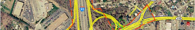
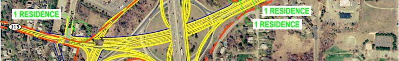
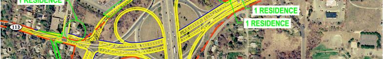
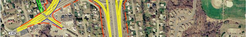
30 Figure 4-12: Alternative 2B Property Impacts Figure 4-13: Alternative 3A Property Impacts 4-30
, any unavoidable impacts to wetlands would need to be replicated at a ratio of 1:1.")


31 Figure 4-14: Alternative 3B Property Impacts Mitigation Costs In accordance with the Massachusetts Wetlands Protection Act (WPA), any unavoidable impacts to wetlands would need to be replicated at a ratio of 1:1. For any wetland resource area impacts, a wetland replication plan would be developed that includes the location of the replication areas, typical cross sections, conceptual grading plans, test pits or soil borings logs, groundwater elevations, the hydrology of areas to be altered and replicated, and a full description of the vegetative species to be altered as well as the vegetative species of the replacement areas, planned construction sequence, and a discussion of the required performance standards and post-construction monitoring. Cost estimates for the design and construction of wetland mitigation areas would range from $150,000 to $300, Evaluation of Transit, Park & Ride, and ITS Options The transit, Park & Ride, and ITS options developed in Chapter 3 were evaluated to identify conceptual-level benefits and costs. A set of evaluation criteria for these options was developed using the same base criteria that were defined early in the study (summarized in Chapter 1) to respond to the study goals and objectives. For each of the relevant base criteria, an appropriate 4-31
Public Informational Meeting November 8, 2007 Route 110 and 113 Methuen Rotary Interchange Study
 Public Informational Meeting November 8, 2007 Route 110 and 113 Methuen Rotary Interchange Study Welcome and Introductions Review of Planning Process Prior Study vs. Current Study Timeline and Implementation
DRAFT. SR-60 7 th Avenue Intersection Control Evaluation (ICE) I-605 Corridor Improvement Project (CIP) I-605/SR-60 EA# 3101U0
 I-605 Corridor Improvement Project (CIP) I-605/SR-60 EA# 3101U0") SR-60 7 th Avenue Intersection Control Evaluation (ICE) I-605/SR-60 EA# 3101U0 October 9, 2017 Contents 1 Purpose of ICE Memo... 1 2 Background... 1 3 Existing Interchange Deficiencies... 1 4 Context Sensitive
SR-60 7 th Avenue Intersection Control Evaluation (ICE) I-605/SR-60 EA# 3101U0 October 9, 2017 Contents 1 Purpose of ICE Memo... 1 2 Background... 1 3 Existing Interchange Deficiencies... 1 4 Context Sensitive
PROJECT STUDY REPORT. Cal Poly Pomona Senior Project
 06/2014 PROJECT STUDY REPORT (Cal Poly Pomona Senior Project) For Conceptual Approval of an Interchange Improvement And Cooperative Agreement with The City of Lake Elsinore for completion of Project Approval
I 75 PD&E STUDIES TABLE OF CONTENTS DTTM, TECHNICAL REPORT No. 2 TABLE OF CONTENTS
 TABLE OF CONTENTS DTTM, TECHNICAL REPORT No. 2 TABLE OF CONTENTS SECTION PAGE NO. SECTION TITLE NO. EXECUTIVE SUMMARY -------------------------------------------------------------------- ES-1 1.0 INTRODUCTION
The Folded Interchange: An Unconventional Design for the Reconstruction of Cloverleaf Interchanges
 The Folded Interchange: An Unconventional Design for the Reconstruction of Cloverleaf Interchanges I. ABSTRACT Keith A. Riniker, PE, PTOE This paper presents the Folded Interchange design and compares
FOR INTERSTATE 81 AND ROUTE 37 INTERCHANGE FREDERICK COUNTY, VIRGINIA MILEPOST 310
 INTERCHANGE MODIFICATION REPORT FOR INTERSTATE 81 AND ROUTE 37 INTERCHANGE FREDERICK COUNTY, VIRGINIA MILEPOST 310 PREPARED BY: VIRGINIA DEPARTMENT OF TRANSPORTATION STAUNTON DISTRICT DECEMBER 13, 2006
VIII. LAND USE ISSUES
 VIII. LAND USE ISSUES The & Route 57 Land Use and Circulation Study (Land Use Study, Figure 6) was completed for the Town of Clay in November 1999 (Clough, Harbour & Associates). This study investigated
Environmental Consequences and Mitigation
 Chapter 4 Environmental Consequences and Mitigation 4.1 Introduction This chapter provides a detailed description of the impacts (and indirect impacts where applicable) associated with the alternatives
TRANSPORTATION PROJECT REPORT DRAFT CONCEPTUAL ACCESS MODIFICATION PROPOSAL OCTOBER 2002
 TRANSPORTATION INTERSTATE 87 INTERCHANGE 11A TOWN OF MALTA SARATOGA COUNTY, NY DRAFT CONCEPTUAL ACCESS MODIFICATION PROPOSAL OCTOBER 2002 PROJECT REPORT NEW YORK STATE DEPARTMENT OF TRANSPORTATION JOSEPH
MEMORANDUM: INITIAL CONCEPTS SUMMARY
 MEMORANDUM: INITIAL CONCEPTS SUMMARY INTRODUCTION This memo presents a summary of initial concepts that have been identified as development of the project study has progressed, along with a recommendations
Appendix D Functional Classification Criteria and Characteristics, and MnDOT Access Guidance
 Appendix D Functional Classification Criteria and Characteristics, and MnDOT Access Guidance Functional classification identifies the role a highway or street plays in the transportation system. Some highways
Military Highway Interchange
 III. Military Highway Interchange Deficiencies Design Challenges Proposed Alternatives III.1.2 Volumes & Operations Figure III.2: Existing Volumes displays the existing volumes for the Military Highway
DDI s Can Move More Than Cars. Alex Ariniello. Presentation for the ITE Western District Annual Meeting. July, 2016 in Albuquerque, New Mexico
 DDI s Can Move More Than Cars Alex Ariniello Presentation for the ITE Western District Annual Meeting July, 2016 in Albuquerque, New Mexico In January, 2016, a Diverging Diamond Interchange (DDI) opened
WOO-SR Feasibility Study (PID 90541) Feasibility Study Report April 22, 2011
 Feasibility Study Report April 22, 2011") TABLE OF CONTENTS EXECUTIVE SUMMARY... 1 CHAPTER 1: INTRODUCTION... 5 1.1 Study Purpose and background... 5 1.2 Study Approach... 6 1.3 Study Area... 6 CHAPTER 2: DESCRIPTIONS OF ALTERNATIVES... 7 2.1
TABLE OF CONTENTS EXECUTIVE SUMMARY... 1 CHAPTER 1: INTRODUCTION... 5 1.1 Study Purpose and background... 5 1.2 Study Approach... 6 1.3 Study Area... 6 CHAPTER 2: DESCRIPTIONS OF ALTERNATIVES... 7 2.1
9.0 I-26 & I-526 Interchange Improvements
 9.0 I-26 & I-526 Interchange Improvements The I-26 & I-526 System-to-System interchange currently consists of a combination of directional and loop ramps providing for all movements from one Interstate
Appendix D: Functional Classification Criteria and Characteristics, and MnDOT Access Guidance
 APPENDICES Appendix D: Functional Classification Criteria and Characteristics, and MnDOT Access Guidance D.1 Functional classification identifies the role a highway or street plays in the transportation
WELCOME IL 47. Community Advisory Group Meeting #5 Waubonsee Community College Wednesday, May 31, 2017
 WELCOME IL 47 Community Advisory Group Meeting #5 Waubonsee Community College Wednesday, May 31, 2017 MEETING PURPOSE MEETING AGENDA 1. Welcome/Introduction 2. Review Previous Public Involvement 3. Process/Schedule
Community Advisory Committee Meeting No. 2. June 22, 2006
 Community Advisory Committee Meeting No. 2 June 22, 2006 Introductions The Study Team KDOT Wichita Partners Consultants CAC members Overview Today s Agenda Opinion Survey Study Status Starting Concept
St. Francis Drive through the City of Santa Fe Corridor Study
 VIII. ENGINEERING AND ENVIRONMENTAL EVALUATION INTERSECTION IMPROVEMENTS SOUTHERN For the southern end of the corridor, traffic volumes are expected to increase over existing levels. The Phase A Report
Appendix C - Highway 400 Widening and Interchange Evaluation Summary Tables
 Highway 400 Improvements from 1 km South of Highway 89 to the Junction of Highway 11 Appendix C - Highway 400 Widening and Interchange Tables Prepared for: Ontario Ministry of Transportation Four General
M D 355 [FR E D E R IC K R O A D] OVER
![M D 355 [FR E D E R IC K R O A D] OVER](/thumbs/79/79553721.jpg "M D 355 [FR E D E R IC K R O A D] OVER") M D 355 [FR E D E R IC K R O A D] OVER LITTLE BENNETT CREEK MAINTENANCE OF TRAFFIC ALTERNATIVE ANA LYSIS Prepared by: INTRODUCTION The purpose of this report is to present the results of traffic analyses
M D 355 [FR E D E R IC K R O A D] OVER LITTLE BENNETT CREEK MAINTENANCE OF TRAFFIC ALTERNATIVE ANA LYSIS Prepared by: INTRODUCTION The purpose of this report is to present the results of traffic analyses
Informational Brochure. Proposed Interchange. Interstate Route 295 (I-295) AT Greenville Avenue (State Route 5) Town of Johnston, Rhode Island
 AT Greenville Avenue (State Route 5) Town of Johnston, Rhode Island") Informational Brochure Proposed Interchange OF Interstate Route 295 (I-295) AT Greenville Avenue (State Route 5) Town of Johnston, Rhode Island October 5, 2016 Department of Transportation Two Capitol
Informational Brochure Proposed Interchange OF Interstate Route 295 (I-295) AT Greenville Avenue (State Route 5) Town of Johnston, Rhode Island October 5, 2016 Department of Transportation Two Capitol
APPENDIX B. Excerpts from the October 2002 Conceptual Alternatives Report
 APPENDIX B Excerpts from the October 2002 Interstate 83 and PA Route 921 The objective for the SR 921 interchange site was to study alternatives for construction of a new interchange. There are no short-term
Conceptual Design Report
 Conceptual Design Report I-244/Arkansas River Multimodal Bridge Tulsa, Oklahoma Prepared for the Oklahoma Department of Transportation Prepared by: August 2009 I-244 / ARKANSAS RIVER MULTIMODAL BRIDGE
FINAL PROJECT PRIORITIZATION PLAN FOR THE NM 599 CORRIDOR
 FINAL PROJECT PRIORITIZATION PLAN FOR THE NM 599 CORRIDOR PROJECT NO. WIP-599-1(102) CONTROL NO. D5SF2 APRIL 2010 Prepared for: New Mexico Department of Transportation Northern Design Bureau P.O. Box 1149
Going/Greeley Interchange Enhancements for Truck Operations
 Going/Greeley Interchange Enhancements for Truck Operations City of Portland Table of Contents What Is The Problem?.1 What Is The Purpose Of The Study?...1 Review Of Alternatives.1 Table: Estimated Cost
I-35/80 Operations Study: Douglas Avenue to NW 86 th Street FOR
 : Douglas Avenue to NW 86 th Street FOR Iowa Department of Transportation City of Urbandale City of Grimes February 7, 2013 FINAL Prepared by: HR Green, Inc. HR Green Project Number: 40110031 TABLE OF
GUIDE FOR THE PREPARATION OF TRAFFIC IMPACT STUDIES
 GUIDE FOR THE PREPARATION OF TRAFFIC IMPACT STUDIES Adopted by Town Council on November 25, 2008 Prepared By: HNTB Engineering Department Planning Department TABLE OF CONTENTS I. INTRODUCTION... 1 II.
Traffic Impact Study Guidelines. City of Guelph
 Traffic Impact Study Guidelines City of Guelph April 2016 Engineering and Capital Infrastructure Services Infrastructure, Development & Enterprise 1 Carden Street Guelph, Ontario Canada N1H 3A1 Page 1
NW La Center Road/I-5 Interchange Improvement Project (MP 16.80)
") FINAL DRAFT - NW La Center Road/I-5 Interchange Improvement Project (MP 16.80) La Center, Washington February 2015 FINAL DRAFT - NW La Center Road/I-5 Interchange Improvement Project (MP 16.80) La Center,
FINAL DRAFT - NW La Center Road/I-5 Interchange Improvement Project (MP 16.80) La Center, Washington February 2015 FINAL DRAFT - NW La Center Road/I-5 Interchange Improvement Project (MP 16.80) La Center,
I-10 CORRIDOR IMPROVEMENTS STAGE 0 FEASIBILITY STUDY STATE PROJECT NUMBER H FEDERAL AID PROJECT NUMBER H004100
 JULY 2016 I-10 CORRIDOR IMPROVEMENTS STAGE 0 FEASIBILITY STUDY STATE PROJECT NUMBER H.004100 FEDERAL AID PROJECT NUMBER H004100 EAST BATON ROUGE AND WEST BATON ROUGE PARISHES, LOUISIANA Section TABLE OF
NORTHWEST CORRIDOR PROJECT. NOISE TECHNICAL REPORT 2015 Addendum Phase IV
 Noise Technical Report 2015 Addendum NOISE TECHNICAL REPORT 2015 Addendum PREPARED FOR: Federal Highway Administration and Georgia Department of Transportation PREPARED BY: Parsons Brinckerhoff Project
Executive Summary. ES.1 Project Overview
 ES.1 Project Overview The New Hampshire Department of Transportation (NHDOT) and the Federal Highway Administration (FHWA) have prepared this Environmental Assessment/Draft Section 4(f) Evaluation (EA/4(f))
12 Evaluation of Alternatives
 12 Evaluation of Alternatives This chapter evaluates the effectiveness of the No-Build Alternative and the proposed METRO Blue Line Light Rail Transit (BLRT) Extension project based on the information
NEPA and Design Public Hearings
 NEPA and Design Public Hearings Monday, December 5, 2016 Washington-Lee High School 1301 N. Stafford Street Arlington, VA 22201 Thursday, December 8, 2016 Mary Ellen Henderson Middle School 7130 Leesburg
BCEO TRAFFIC IMPACT STUDY GUIDELINES
 BCEO TRAFFIC IMPACT STUDY GUIDELINES February 2006 TABLE OF CONTENTS INTRODUCTION..... i TRAFFIC IMPACT STUDY STRUCTURE... 1 WHEN IS A TRAFFIC IMPACT STUDY NEEDED?..... 1 STUDY AREA, SITE PLAN & HORIZON
INTERCHANGE MODIFICATION REPORT
 INTERSTATE 75 AND STATE ROAD 884 (COLONIAL BOULEVARD) INTERCHANGE LEE COUNTY, FLORIDA INTERCHANGE MODIFICATION REPORT Prepared for: Florida Department of Transportation District One May 2017 Interchange
Lynnwood Link Extension 2013 Draft EIS Comments and Responses. Page 945
 I-441-001 Thank you for your comments about the importance of the Latvian Center to the Latvian community. Following the Draft EIS, the Sound Transit Board directed Sound Transit to develop a Preferred
MAY 4, Noise Barrier Presentation NE Quadrant Smith Avenue, Cherry Hill Circle NOISE BARRIER ABUTTER MEETING. Tech Environmental, Inc.
 MAY 4, 2011 Noise Barrier Presentation NE Quadrant Smith Avenue, Cherry Hill Circle 1 Introductions Agenda Overview of Interchange Project Overview of noise barrier process Fundamentals of sound & proposed
Rivers Edge Alternative Urban Areawide Review (AUAR) Traffic Study
 Traffic Study") Appendix F Rivers Edge Alternative Urban Areawide Review (AUAR) Traffic Study Prepared by Westwood Professional Services, Inc. for City of St. Paul Park Grey Cloud Island Township October 14, 2003 Introduction
Appendix F Rivers Edge Alternative Urban Areawide Review (AUAR) Traffic Study Prepared by Westwood Professional Services, Inc. for City of St. Paul Park Grey Cloud Island Township October 14, 2003 Introduction
Traffic Impact Analysis Guidelines. Town of Queen Creek
 Traffic Impact Analysis Guidelines Town of Queen Creek January 2016 1. INTRODUCTION The purpose of this document is to outline the procedures and requirements for preparing a Transportation Impact Analysis
Executive Summary. How to Use this Document
 How to Use this Document In the Final Environmental Impact Statement (EIS) and this Executive Summary: Text from the Draft EIS that remains substantially unchanged, including minor edits such as correction
NOISE REPORT ADDENDUM July 2003
 Coalfields Expressway Section A Buchanan County, Virginia NOISE REPORT ADDENDUM July 2003 Current VDOT Project Number: 0121-013-101, PE101 Former VDOT Project Number: R000-961-101, PE101 Noise Study Addendum
Woodburn Interchange Project Transportation Technical Report
 Final Report Woodburn Interchange Project Transportation Technical Report Prepared for Oregon Department of Transportation April 212 Prepared by DKS Associates Contents Methodologies... 4 Volume Development...
TABLE OF CONTENTS. Section Section 2 Alternative A...7 Section 2 Alternative B...7
 TABLE OF CONTENTS I. General Description...................................................... 3 II. Need for Project.......................................................... 3 III. Adjacent Projects........................................................
SUMMARY S.1 PROJECT DESCRIPTION AND LOCATION S.2 PURPOSE AND NEED
 S SUMMARY S.1 PROJECT DESCRIPTION AND LOCATION The Virginia Department of Transportation (VDOT), in cooperation with the Federal Highway Administration (FHWA), is studying alternatives to meet transportation
Mendocino Forest Products Grading For Industrial Land Improvements
 Mendocino Forest Products Grading For Industrial Land Improvements Technical Memorandum #10 CEQA Evaluation of Environmental Impacts Prepared for: Mendocino Forest Products Company, LLC Consulting Engineers
I-65/I-70 North Split Interchange Reconstruction Project Frequently Asked Questions
 I-65/I-70 North Split Interchange Reconstruction Project Frequently Asked Questions General Overview What is the I-65/I-70 North Split Reconstruction Project? The I-65/I-70 North Split Reconstruction Project
Traffic Impact Study Requirements
 [TYPE THE COMPANY NAME] Traffic Impact Study Requirements County of San Mateo Department of Public Works Roadway Services 9/1/2013 I. Introduction The County of San Mateo (County), Department of Public
CHAPTER 4.0 ENVIRONMENTAL SETTING, IMPACTS, AND MITIGATION
 CHAPTER 4.0 ENVIRONMENTAL SETTING, IMPACTS, AND MITIGATION Sections 4.1 through 4.14 of Chapter 4.0 of this EIR contain a discussion of the potential environmental effects from implementation of the proposed
Beltline Interchange Range of Alternatives Screening Summary Memo
 Range of Alternatives Screening Summary Memo (Concurrence Point #2 from the Agency Coordination Plan) (I-39/90 and US 12/18 Interchange) Dane County, Wisconsin WisDOT Project ID 1007-10-02 Table of Contents
DEVELOPMENT, ANALYSIS, AND DESIGN OF A NEW PARKWAY AT GRADE INTERSECTION (PAGI)
") 2013 ITE Western District Annual Meeting COCEPT DEVELOPMET, AALYSIS, AD DESIG OF A EW PARKWAY AT GRADE ITERSECTIO (PAGI) Lead Author: James M. Witkowski, PhD Supporting Author: Darrell Truitt, PE The Pima
2013 ITE Western District Annual Meeting COCEPT DEVELOPMET, AALYSIS, AD DESIG OF A EW PARKWAY AT GRADE ITERSECTIO (PAGI) Lead Author: James M. Witkowski, PhD Supporting Author: Darrell Truitt, PE The Pima
Chapter 4: Transportation and Circulation
 Chapter 4: Transportation and Circulation 4.1 Introduction Circulation improvements constructed for the West Valley Logistics Center will improve the functional efficiency of the circulation system in
CHAPTER 2: MODELING METHODOLOGY
 CHAPTER 2: MODELING METHODOLOGY 2.1 PROCESS OVERVIEW The methodology used to forecast future conditions consisted of traditional traffic engineering practices and tools with enhancements to more accurately
SECTION 5: ALTERNATIVES TO THE PROPOSED PROJECT
 City of American Canyon Broadway District Specific Plan Alternatives to the Proposed Project SECTION 5: ALTERNATIVES TO THE PROPOSED PROJECT 5.1 Introduction In accordance with CEQA Guidelines Section
FINDINGS OF FACT and CONCLUSIONS
 FINDINGS OF FACT and CONCLUSIONS I-694/ I-494/ I-94 Interchange Improvements State Project No. 8286-81 Prepared by: Minnesota Department of Transportation July, 2018 CONTENTS STATEMENT OF ISSUE... 2 ADMINISTRATIVE
State Route 8 Bridge Replacement Project
 OPEN HOUSE PUBLIC INVOLVEMENT MEETING Celebration Church 688 Dan Street, Akron, Ohio Tuesday, July 14, 2015 5:00 PM to 7:00 PM State Route 8 Bridge Replacement Project Existing Bridge Future Bridges: Steel
DIVISION I TRAFFIC IMPACT STUDY GUIDELINES ENGINEERING STANDARDS
 CITY OF ALBANY DEPARTMENT OF PUBLIC WORKS DIVISION I TRAFFIC IMPACT STUDY GUIDELINES ENGINEERING STANDARDS Prepared By PUBLIC WORKS DEPARTMENT ALBANY, OREGON 97321 Telephone: (541) 917-7676 TABLE OF CONTENTS
2. Alternatives ENVIRONMENTAL ASSESSMENT US 52 OPERATIONAL IMPROVEMENTS. 2.1 Introduction
 2. Alternatives 2.1 Introduction This chapter discusses the development and evaluation of scenarios and alternatives considered for the proposed action. The goal of this process, which is described in
EXECUTIVE SUMMARY. The IP developed the following purpose and need statement for the Part B I-71 Access Improvement Study.
 EXECUTIVE SUMMARY The Ohio-Kentucky-Indiana Regional Council of Governments (OKI) has conducted the with the following purpose: Develop a comprehensive transportation plan for the Uptown area that serves
4.0 AFFECTED ENVIRONMENT
 4.0 AFFECTED ENVIRONMENT 4.1 Land Use, Zoning and Visual Resources 4.1.1 Land Use The Route 113 corridor is characterized by commercial, residential, and industrial uses, many of them major truck generators.
Summary. Preliminary Alternative Development and Screening. DEIS July 23, 2018
 What is the Carolina Crossroads Project? The South Carolina Department of Transportation (SCDOT), in cooperation with the Federal Highway Administration (FHWA), is proposing to upgrade and redesign a key
4.0 AFFECTED ENVIRONMENT AND ENVIRONMENTAL CONSEQUENCES
 NHDOT Project No. 13065 I-93 Exit 4A EIS 4.0 AFFECTED ENVIRONMENT AND ENVIRONMENTAL CONSEQUENCES 4.1 Introduction This chapter presents the affected environment and the direct effects (environmental consequences)
SOUTHWEST LRT (METRO GREEN LINE EXTENSION)
") 8 Evaluation of Alternatives This chapter evaluates the effectiveness of the No Build Alternative and the Southwest Light Rail Transit (LRT) Project (the Project) based on the information contained in
8 Evaluation of Alternatives This chapter evaluates the effectiveness of the No Build Alternative and the Southwest Light Rail Transit (LRT) Project (the Project) based on the information contained in
2 Purpose and Need. 2.1 Study Area. I-81 Corridor Improvement Study Tier 1 Draft Environmental Impact Statement
 2 Purpose and Need 2.1 Study Area Interstate 81 (I-81) is relied upon for local and regional travel and interstate travel in the eastern United States. It extends 855 miles from Tennessee to New York at
AIR QUALITY TECHNICAL MEMORANDUM
 AIR QUALITY TECHNICAL MEMORANDUM AIR QUALITY TECHNICAL MEMORANDUM GOLDEN GLADES INTERCHANGE PD&E STUDY Miami-Dade County, Florida Financial Management Number: 428358-1-22-01 Efficient Transportation Decision
Existing vs. Proposed Ramp Noise Sensitivity Analysis Austin Boulevard Interchange
 I-290 Phase I Study West of US 45 (Mannheim Road) to Racine Avenue Existing vs. Proposed Ramp Noise Sensitivity Analysis Austin Boulevard Interchange Technical Memorandum Prepared By: Huff & Huff, Inc.
DRAFT AIR QUALITY TECHNICAL MEMORANDUM
 AIR QUALITY TECHNICAL MEMORANDUM PROJECT DEVELOPMENT AND ENVIRONMENT STUDY STATE ROAD 60 GRADE SEPARATION OVER CSX RAILROAD Polk County, Florida Financial Project ID: 436559-1-22-01 Prepared for: Florida
Bow Concord I-93 Improvements City of Concord Transportation Policy Advisory Committee
 Bow Concord I-93 Improvements City of Concord Transportation Policy Advisory Committee December 15, 2016 Agenda Project History / Project Development Process Traffic Modeling Alternatives Development o
Transportation Facility Inventory
 CHAPTER 3 Transportation Element Section 3.1 Introduction Movement of people, goods, and services within and through the Town is an integral part of everyday life for the citizens of Hull. Decisions made
Green Line extension Project Fall 2009
 Introduction The Massachusetts Department of Transportation (MassDOT) is proposing to extend the Green Line to improve transit service, mobility, and regional access for residents and visitors of Cambridge,
GRE PID 80468
 Assessment of Feasible Alternatives Prepared for Ohio Department of Transportation 505 South SR 741 Lebanon, OH 45036-9518 December 2011 One Dayton Centre, Suite 1100 One South Main Street Dayton, OH 45402
Interchange Workshop Report (August 2004)
") U.S. Highway 14 Corridor Study New Ulm to North Mankato Table of Contents Section Interchange Workshop Report (August 2004) Page 1. Introduction and Next Steps 1 2. Interchange Workshop Participants &
U.S. Highway 14 Corridor Study New Ulm to North Mankato Table of Contents Section Interchange Workshop Report (August 2004) Page 1. Introduction and Next Steps 1 2. Interchange Workshop Participants &
5.0 PRELIMINARY ENVIRONMENTAL REVIEW
 5.0 PRELIMINARY ENVIRONMENTAL REVIEW 5.1 INTRODUCTION A preliminary environmental review was performed on the proposed freeway improvements that form Concept C, which encompasses the three freeway corridors
Consideration of a Diverging Diamond Interchange in Saskatchewan. Paul H. A. Steel, Project Manager, M. Eng., P.Eng., Tetra Tech EBA Inc.
 Consideration of a Diverging Diamond Interchange in Saskatchewan Paul H. A. Steel, Project Manager, M. Eng., P.Eng., Tetra Tech EBA Inc. Terry Schmidt, P.Eng., MBA, Senior Project Director, Tetra Tech
HIGHWAY 71 CORRIDOR IMPROVEMENT STUDY BELLA VISTA BYPASS MISSOURI STATE LINE BENTON COUNTY
 HIGHWAY 71 CORRIDOR IMPROVEMENT STUDY BELLA VISTA BYPASS MISSOURI STATE LINE BENTON COUNTY DRAFT December 2017 Highway 71 Corridor Improvement Study Bella Vista Bypass to Missouri State Line BENTON COUNTY
VII. FREIGHT MANAGEMENT
 VII. FREIGHT MANAGEMENT The regional transportation network must not only move people safely and efficiently, but must also facilitate the safe and efficient transportation of goods as well. Local freight
CHAPTER 8: I-71 ACCESS IMPROVEMNETS
 CHAPTER 8: I-71 ACCESS IMPROVEMNETS I-71 Access Improvements were a separate and distinct part of the overall Uptown Transportation Study. This Part B work is fully documented in the Planning Study Report
CITY OF SAN MATEO GENERAL PLAN MITIGATION MONITORING AND REPORTING PROGRAM
 CITY OF SAN MATEO GENERAL PLAN MITIGATION MONITORING AND REPORTING PROGRAM INTRODUCTION This document is the (MMRP) for the Mateo General Plan. This MMRP has been prepared pursuant to Section 21081.6 of
On behalf of the Carolina Crossroads project team we thank you for taking the time to attend this meeting.
 On behalf of the Carolina Crossroads project team we thank you for taking the time to attend this meeting. Located in the heart of South Carolina, the I-20/26/126 Corridor is the crossroads of the state
Route 7 Connector Ramp MODIF IE D I N T ER C H A N G E M OD IFICATIO N R E PO RT TRA N S F O R M I : I N S ID E THE BE LTWAY
 STATE PROJECT NUMBER: 0066-96A-493,P101, C501, B686; UPC: 110629 FEDERAL PROJECT NUMBER: NHPP-066-1(356) FAIRFAX COUNTY, VIRGINIA TRA N S F O R M I - 6 6 : I N S ID E THE BE LTWAY Route 7 Connector Ramp
Traffic Impact Analysis (TIA) POLICY
 POLICY") Ascension Parish Planning Commission Traffic Impact Analysis (TIA) POLICY This policy establishes requirements for studies that provide information on traffic projected to be generated by all proposed
Ascension Parish Planning Commission Traffic Impact Analysis (TIA) POLICY This policy establishes requirements for studies that provide information on traffic projected to be generated by all proposed
Future Build Alternative Traffic Forecasts and Level of Service Analysis
 4.2.10 Future Build Alternative Traffic Forecasts and Level of Service Analysis For the five Build Alternatives, study intersections within one mile of potential station locations were analyzed, as it
TABLE OF CONTENTS 3.0 AFFECTED ENVIRONMENT AND ENVIRONMENTAL CONSEQUENCES
 TABLE OF CONTENTS 1.0 PURPOSE AND NEED -------------------------------------------------------------------------------------------- 1-1 1.1 STUDY AREA -----------------------------------------------------------------------------------------------------
I-90 / I-495 Interchange Improvements Project Hopkinton-Westborough- Southborough
 I-90 / I-495 Interchange Improvements Project Hopkinton-Westborough- Southborough December, 2014 Introduction / Welcome Paul Matthews, Executive Director, 495 MetroWest Partnership Renata Welch, MassDOT
ALBION FLATS DEVELOPMENT EXISTING TRAFFIC CONDITIONS AND POTENTIAL IMPACTS
 EXISTING TRAFFIC CONDITIONS AND POTENTIAL IMPACTS FINAL REPORT SEPTEMBER 2010 TABLE OF CONTENTS 1.0 INTRODUCTION 1 2.0 EXISTING TRAFFIC CONDITIONS 2 3.0 FUTURE TRAFFIC CONDITIONS 3 4.0 POTENTIAL IMPACTS
Final Air Quality Report
 Florida Department of TRANSPORTATION Final Air Quality Report PD&E Study From East of Babcock Street (SR 507) to US 1 Brevard County, Florida Financial Project ID: 430136-1-22-01 ETDM Project Number: 13026
January 16, Rhode Island Energy Facilities Siting Board 89 Jefferson Boulevard Warwick, Rhode Island 02888
 INVENERGY 196 January 16, 2019 Rhode Island Energy Facilities Siting Board 89 Jefferson Boulevard Warwick, Rhode Island 02888 Re: Clear River Energy Center Invenergy Docket No. SB-2015-06 When Invenergy
City of Berkeley. Guidelines for Development of Traffic Impact Reports
 Office of Transportation (OOT) City of Berkeley Guidelines for Development of Traffic Impact Reports Office of Transportation, City of Berkeley 1 1. Overview These guidelines provide a framework to help
PUBLIC INFORMATION MEETING TUESDAY MARCH 9, 2010
 St. Francis Drive Corridor Study Draft Phase B Review 1 PUBLIC INFORMATION MEETING TUESDAY MARCH 9, 2010 Objective Present Alternatives Evaluated Solicit Feedback On Selection of Recommended Projects 2
I-70 East PACT DRAFT EVALUATION DATA
 I-70 East PACT DRAFT EVALUATION DATA Future Current Alignment NEIGHORHOOD QUALITY: Maintain quality of life and protect community values. Improve or maintain neighborhood connectivity Assess neighborhood
Patrick Prescott, Community Development Director By: David L. Kriske, Assistant Community Development Director
 DATE: April 26, 2016 TO: FROM: Ron Davis, Interim City Manager Patrick Prescott, Community Development Director By: David L. Kriske, Assistant Community Development Director SUBJECT: Modification of two
Appendix C. Wetland Impact Assessment and Two-Part Finding. I-94 St. Michael to Albertville Minnesota Department of Transportation
 Appendix C Wetland Impact Assessment and Two-Part Finding I-94 St. Michael to Albertville Minnesota Department of Transportation Office of Environmental Stewardship 395 John Ireland Blvd. St. Paul, MN
Chapter 2: Alternatives
 Chapter 2: Alternatives Introduction An Environmental Impact Statement (EIS) is a procedural document. In other words, the environmental planning process follows a logical sequence of development. Subsequent
Northeast Interstate Logistics Center
 Northeast Interstate Logistics Center Town of Southeast, New York Planning Board Meeting July 23, 2018 1 of 42 KEY PROJECT BENEFITS Modern 1,125,000 sf logistics center with strong market demand-responsive
TABLE OF CONTENTS TABLE OF CONTENTS... I APPENDICES... III LIST OF EXHIBITS... V LIST OF TABLES... VII LIST OF ABBREVIATED TERMS...
 Amendment No. 2 to Reclamation Plan 2006-01 Traffic Impact Analysis TABLE OF CONTENTS TABLE OF CONTENTS... I APPENDICES... III LIST OF EXHIBITS... V LIST OF TABLES... VII LIST OF ABBREVIATED TERMS... IX
Welcome. Public Meeting. August 2, :00 to 7:00 p.m. Presentation 6:00 to 6:30 p.m.
 Welcome Public Meeting August 2, 2017 5:00 to 7:00 p.m. Presentation 6:00 to 6:30 p.m. www.glenwoodsouthbridge.net Welcome to the South Bridge Environmental Assessment Public Meeting Why Are We Here Tonight?
MEMORANDUM. Date: July 14, 2006 Project #: To: US 97 & US 20 Refinement Plan Steering Committee
 MEMORANDUM Date: July 14, 2006 Project #: 6389 To: US 97 & US 20 Refinement Plan Steering Committee From: Sonia Hennum, P.E., Andrew Cibor, E.I.T., & Julia Kuhn, P.E. Project: US 97 & US 20 Refinement
I-65/I-70 North Split Project
 I-65/I-70 North Split Project Public Open House October 10, 2018 Alternatives Development Process Define Problems Identify Context Gather Input Define Alternatives Balance Trade-Offs Select Alternative
WELCOME COMMUNITY ADVISORY GROUP MEETING #2
 WELCOME COMMUNITY ADVISORY GROUP MEETING #2 Joliet Junior College OUTLINE / AGENDA Recap of CAG #1 Presentation Recap of CAG #1 Workshop Context Audit / Survey Results Draft Problem Statement Draft Purpose