NRCS Hydrology methodology review Minnesota NRCS recommendation MnDOT recommendation Using Atlas 14 with HydroCAD
|
|
|
- Lambert Armstrong
- 6 years ago
- Views:
Transcription

1 Dec, 2015
2 NRCS Hydrology methodology review Minnesota NRCS recommendation MnDOT recommendation Using Atlas 14 with HydroCAD
3 NRCS - Natural Resource Conservation Service (formerly known as SCS Soil Conservation Service) developed/support rainfall/runoff hydrology method NRCS uses to design small agricultural ponds, waterways and erosion control NRCS Hydrology methods typically used by MnDOT and most others in Minnesota when hydrograph analysis needed such as pond design Also used by MnDOT for peak flow for most culverts where drainage area is smaller than what recommended for StreamStats
4 NRCS/SCS Rainfall/Runoff Hydrology Method Drainage Area Curve Number based on land use and soil properties - proportion of precipitation that will runoff drainage area 24 hour design precipitation Time of Concentration time for water to flow from furthest part of watershed to design point Rainfall distribution intensity of precipitation over time (24 hours) Unit hydrograph rate of flow vs time for the runoff from the watershed
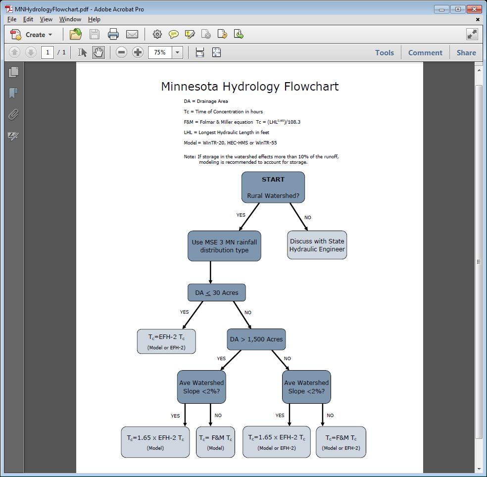
5 Recommendations for NRCS Area and Field Staff for NRCS projects for rural watersheds Use Precipitation Depths from Atlas 14 MSE 3 MN MSE 3 rainfall distribution Synthetic unit hydrograph with peak rate factor of 400 Use Time of Concentration developed from Engineering Field Handbook (EFH2) or Folmar & Miller formula Flowchart
6
7 Tech Memo B-02 Urban Areas Stop using NRCS Type II Rainfall Distribution Use Atlas 14 Rainfall Depth from PFDS server or NRCS County File Use MSE 3 or Atlas 14 Derived Rainfall Distribution Use SCS Typical Unit Hydrograph (peak factor 484) Use Time of Concentration formulas from Drainage Manual/TR-55 Route flow (hydrograph analysis) where have storage
8 Rural Areas Stop using NRCS Type II Rainfall Distribution Use Atlas 14 Rainfall depth Use MSE 3 or Atlas 14 Derived Rainfall Distribution Use standard dimensionless unit hydrograph with peak factor of 484 unless conditions on following slide met. Route flow (hydrograph analysis) if significant storage, especially right upstream of crossing.

9 Rural Areas cont d Minnesota NRCS recommended methodology MSE 3 rainfall distribution Unit Hydrograph with peak factor of 400 Time of Concentration methods per NRCS flowchart MN NRCS MSE 3 MN and Time of Concentration methodology may used for some rural drainage areas when all of the following conditions met: Drainage area is rural Drainage area is not steep Predicted flows are consistent with historical observations at the site.
10 Rainfall Depth use either method below: Import rainfall depths from Atlas 14 PFDS server helpsheet on web site NRCS County file included with HydroCAD 10 Build 15 or higher slides to follow Rainfall Distribution use either method below: Import rainfall distribution from Atlas 14 PFDS server helpsheet on web site NRCS MSE 3 rainfall distribution included with HydroCAD 10 Build 14 or higher slides to follow

11 Select Calculation Settings Dialog and select Rainfall Tab Select MSE 24-hr as Storm Type


12 Then select Storm Curve 3

13 On Calculation Settings dialog/rainfall Tab Go to Rainfall Event and click on Import Events From button Select Lookup Table

14 On Rainfall Event Lookup Table: 1. Select Event Lookup File Atlas-14-Rain.txt 2. Find State = MN 3. Scroll down and find county 4. Click on OK

15 Select MSE 3 as Storm Distribution and OK Data is from Minnesota NRCS County file and is the spatially averaged value for the county.
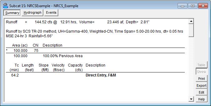
16 Rainfall Distribution Atlas 14 NRCS MSE3 SCS Type II Peak Flow 162 cfs 167 cfs 151 cfs Stearns County Drainage Area = 100 acres Tc = 64 minutes CN = hour Rainfall = 5.68 in
17

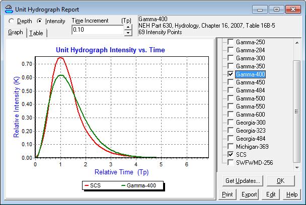
18 SCS is the default Select peak factor 400 dimensionless unit hydrograph by going to Settings > Calculation > Unit Hydro
19 Rainfall Distribution Atlas 14 Peak Flow SCS Unit hydrograph (Peak Factor 484) 162 cfs Peak Flow NRCS Peak Factor 400 NRCS MSE3 167 cfs 145 cfs MSE3 MN SCS Type II 151 cfs Stearns County Tc = 64 minutes CN = hour Rainfall = 5.66 in
20

21 HydroCAD 10 build 15 Includes county data file that includes Atlas 14 data for Minnesota counties HydroCAD 10 build 14 or higher Includes MSE 3 rainfall distribution HydroCAD 10 build prior to 14 Can import Atlas 14 rainfall distribution downloaded from PFDS server Includes unit hydrograph with peak factor 400 HydroCAD version 9 Can not import Atlas 14 rainfall distribution Need to develop a custom rainfall distribution for MSE 3 based on data from NRCS
22 For Peak Flow method - most impact for areas with shorter Time of Concentration If route flow, especially if have significant amounts of storage, the unit hydrograph and rainfall distribution used have much less impact
23 Stop using NRCS Type II rainfall distribution Use Atlas 14 derived distribution or MSE-3 distribution For urban watersheds continue to dimensionless unit hydrograph with peak factor of 484 (default in HydroCAD) Document what is used
24 Allowable to use NRCS Recommended Method for rural areas - MSE 3 MN MSE 3 Rainfall Distribution Unit Hydrograph with peak factor 400 Use engineering judgment and continue to use typical SCS unit hydrograph (PF 484) where higher design flow justified: Rural vs Agricultural Climate Change resilience No Storage History of Flooding Critical locations Steepness/flashiness
Peak discharge computation
 Ia/P 4 Peak Dischage Method Graphical Peak Discharge Method This chapter presents the Graphical Peak Discharge method for computing peak discharge from rural and urban areas. The Graphical method was developed
INFLOW DESIGN FLOOD CONTROL SYSTEM PLAN 40 C.F.R. PART PLANT DANIEL ASH POND B MISSISSIPPI POWER COMPANY
 INFLOW DESIGN FLOOD CONTROL SYSTEM PLAN 40 C.F.R. PART 257.82 PLANT DANIEL ASH POND B MISSISSIPPI POWER COMPANY EPA s Disposal of Coal Combustion Residuals from Electric Utilities Final Rule (40 C.F.R.
Rainfall, Runoff and Peak Flows: Calibration of Hydrologic Design Methods for the Kansas City Area
 Rainfall, Runoff and Peak Flows: Calibration of Hydrologic Design Methods for the Kansas City Area Bruce McEnroe, Bryan Young, Ricardo Gamarra and Ryan Pohl Department of Civil, Environmental, and Architectural
Examination of PRZM5.0 Storm Rainfall Depth and Distribution Algorithms Compared to Current U.S. Storm Trends
 Examination of PRZM5.0 Storm Rainfall Depth and Distribution Algorithms Compared to Current U.S. Storm Trends August 24, 2016 Tammara L. Estes (Stone Environmental Inc.) Kevin L. Armbrust, Ph.D. (Louisiana
INFLOW DESIGN FLOOD CONTROL SYSTEM PLAN 40 C.F.R. Part PLANT MCINTOSH ASH POND 1 GEORGIA POWER COMPANY
 INFLOW DESIGN FLOOD CONTROL SYSTEM PLAN 40 C.F.R. Part 257.82 PLANT MCINTOSH ASH POND 1 GEORGIA POWER COMPANY EPA s Disposal of Coal Combustion Residuals from Electric Utilities Final Rule (40 C.F.R. Part
INFLOW DESIGN FLOOD CONTROL SYSTEM PLAN PLANT BARRY ASH POND ALABAMA POWER COMPANY
 INFLOW DESIGN FLOOD CONTROL SYSTEM PLAN PLANT BARRY ASH POND ALABAMA POWER COMPANY Section 257.82 of EPA s regulations requires the owner or operator of an existing or new CCR surface impoundment or any
INFLOW DESIGN FLOOD CONTROL SYSTEM PLAN PLANT GASTON GYPSUM POND ALABAMA POWER COMPANY
 INFLOW DESIGN FLOOD CONTROL SYSTEM PLAN PLANT GASTON GYPSUM POND ALABAMA POWER COMPANY Section 257.82 of EPA s regulations requires the owner or operator of an existing or new CCR surface impoundment or
RUN-ON AND RUN-OFF CONTROL PLAN 40 C.F.R. PART PLANT DANIEL NORTH ASH MANAGEMENT UNIT MISSISSIPPI POWER COMPANY
 RUN-ON AND RUN-OFF CONTROL PLAN 40 C.F.R. PART 257.81 PLANT DANIEL NORTH ASH MANAGEMENT UNIT MISSISSIPPI POWER COMPANY EPA s Disposal of Coal Combustion Residuals from Electric Utilities Final Rule (40
INFLOW DESIGN FLOOD CONTROL SYSTEM PLAN PLANT GREENE COUNTY ASH POND ALABMA POWER COMPANY
 INFLOW DESIGN FLOOD CONTROL SYSTEM PLAN PLANT GREENE COUNTY ASH POND ALABMA POWER COMPANY Section 257.82 of EPA s regulations requires the owner or operator of an existing or new CCR surface impoundment
Section 2: Hydrology. Introduction. What is the Return Period? Intensity-Duration-Frequency Data. Generating a runoff hydrograph 85 Minutes
 Section 2: Hydrology Generating a runoff hydrograph 85 Minutes Press Space, PageDown, or Click to advance. Press PageUp to reverse. Esc to exit. Right-Click for other options. Copyright 2004 HydroCAD Software
DETENTION BASIN DESIGN USING RATIONAL HYDROGRAPHS
 DETENTION BASIN DESIGN USING RATIONAL HYDROGRAPHS By Thomas F. Smith, P.E., P.L.S. Bercek and Smith Engineering, Inc. www.bercekandsmith.com tfsmith2@bercekandsmith.com 1 Topics Covered: 2 1 Attributed
INFLOW DESIGN FLOOD CONTROL SYSTEM PLAN 40 C.F.R. PART PLANT YATES ASH POND B (AP-B ) GEORGIA POWER COMPANY
 GEORGIA POWER COMPANY") INFLOW DESIGN FLOOD CONTROL SYSTEM PLAN 40 C.F.R. PART 257.82 PLANT YATES ASH POND B (AP-B ) GEORGIA POWER COMPANY EPA s Disposal of Coal Combustion Residuals from Electric Utilities Final Rule (40 C.F.R.
INFLOW DESIGN FLOOD CONTROL SYSTEM PLAN 40 C.F.R. PART 257.82 PLANT YATES ASH POND B (AP-B ) GEORGIA POWER COMPANY EPA s Disposal of Coal Combustion Residuals from Electric Utilities Final Rule (40 C.F.R.
INFLOW DESIGN FLOOD CONTROL SYSTEM PLAN 40 C.F.R. PART PLANT YATES ASH POND 3 (AP-3) GEORGIA POWER COMPANY
 GEORGIA POWER COMPANY") INFLOW DESIGN FLOOD CONTROL SYSTEM PLAN 40 C.F.R. PART 257.82 PLANT YATES ASH POND 3 (AP-3) GEORGIA POWER COMPANY EPA s Disposal of Coal Combustion Residuals from Electric Utilities Final Rule (40 C.F.R.
INFLOW DESIGN FLOOD CONTROL SYSTEM PLAN 40 C.F.R. PART 257.82 PLANT YATES ASH POND 3 (AP-3) GEORGIA POWER COMPANY EPA s Disposal of Coal Combustion Residuals from Electric Utilities Final Rule (40 C.F.R.
Software Applications for Runoff Hydrological Assessment
 Bulletin UASVM Horticulture, 67(2)/2010 Print ISSN 1843-5254; Electronic ISSN 1843-5394 Software Applications for Runoff Hydrological Assessment Severin CAZANESCU 1), Sorin CIMPEANU 1), Oana GUI 2), Dana
Engineering Hydrology Class 3
 Engineering Hydrology Class 3 Topics and Goals: I.Develop s (estimate precipitation) II.Develop simple constant intensity design storm III.Develop SCS design storm Ocean s Why do we want to derive the?
APPENDIX E APPENDIX E ESTIMATING RUNOFF FOR SMALL WATERSHEDS
 APPENDIX E ESTIMATING RUNOFF FOR SMALL WATERSHEDS March 18, 2003 This page left blank intentionally. March 18, 2003 TABLES Table E.1 Table E.2 Return Frequencies for Roadway Drainage Design Rational Method
INFLOW DESIGN FLOOD CONTROL SYSTEM PLAN 40 C.F.R. PART PLANT BOWEN ASH POND 1 (AP-1) GEORGIA POWER COMPANY
 GEORGIA POWER COMPANY") INFLOW DESIGN FLOOD CONTROL SYSTEM PLAN 40 C.F.R. PART 257.82 PLANT BOWEN ASH POND 1 (AP-1) GEORGIA POWER COMPANY EPA s Disposal of Coal Combustion Residuals from Electric Utilities Final Rule (40 C.F.R.
INFLOW DESIGN FLOOD CONTROL SYSTEM PLAN 40 C.F.R. PART 257.82 PLANT BOWEN ASH POND 1 (AP-1) GEORGIA POWER COMPANY EPA s Disposal of Coal Combustion Residuals from Electric Utilities Final Rule (40 C.F.R.
BMP Design Aids. w w w. t r a n s p o r t a t i o n. o h i o. g o v. Equations / Programs
 BMP Design Aids 1 Equations / Programs Outlet Discharge Equations Hydrograph and Pond Routing Programs USGS StreamStats 2 Ohio Department of Transportation 1 Training Intent Introduction and overview of
APPENDIX E ESTIMATING RUNOFF FROM SMALL WATERSHEDS
 ESTIMATING RUNOFF FROM SMALL WATERSHEDS June 2011 THIS PAGE LEFT BLANK INTENTIONALLY. June 2011 TABLES Table E.1 Table E.2 Return Frequencies for Roadway Drainage Design Rational Method Values June 2011
Atlas 14: The New Rainfall Atlas
 Atlas 14: The New Rainfall Atlas Olmsted County Environmental Commission Trends Subcommittee September 17, 2014 Presenter: Art Kalmes, PE, CFM Vice President Barr Engineering Co. akalmes@barr.com 952-832-2990
APPENDIX IV. APPROVED METHODS FOR QUANTIFYING HYDROLOGIC CONDITIONS OF CONCERN (NORTH ORANGE COUNTY)
") APPENDIX IV. APPROVED METHODS FOR QUANTIFYING HYDROLOGIC CONDITIONS OF CONCERN (NORTH ORANGE COUNTY) Hydromodification design criteria for the North Orange County permit area are based on the 2- yr, 24-hr
APPENDIX IV. APPROVED METHODS FOR QUANTIFYING HYDROLOGIC CONDITIONS OF CONCERN (NORTH ORANGE COUNTY) Hydromodification design criteria for the North Orange County permit area are based on the 2- yr, 24-hr
Learn how to design inlet grates, detention basins, channels, and riprap using the FHWA Hydraulic Toolbox and WMS
 v. 11.0 WMS 11.0 Tutorial Learn how to design inlet grates, detention basins, channels, and riprap using the FHWA Hydraulic Toolbox and WMS Objectives Learn how to use several Hydraulic Toolbox calculators
Appendix A. Compliance Calculator Guidance
 Compliance Calculator Guidance Appendix A Appendix A. Compliance Calculator Guidance A.1 Introduction The Center for Watershed Protection created the compliance calculator spreadsheet to allow a designer
Overview of NRCS (SCS) TR-20 By Dr. R.M. Ragan
 TR-20 By Dr. R.M. Ragan") Overview of NRCS (SCS) TR-20 By Dr. R.M. Ragan TR-20 is a computer program for the simulation of runoff occurring from a single storm event. The program develops flood hydrographs from runoff and routes
Overview of NRCS (SCS) TR-20 By Dr. R.M. Ragan TR-20 is a computer program for the simulation of runoff occurring from a single storm event. The program develops flood hydrographs from runoff and routes
IBS Site Drainage: Senior Design Project
 IBS Site Drainage: Senior Design Project Len Wright, Ph.D., PE Lecturer, CEAE Wright.Len@gmail.com September 11, 2008 mwsw204i1.ppt/1 OUTLINE Motivation for Stormwater Management Quantity (both onsite,
INITIAL RUN-ON AND RUN-OFF CONTROL PLAN 40 C.F.R. PART 257
 INITIAL RUN-ON AND RUN-OFF CONTROL PLAN 40 C.F.R. PART 257.81 HUFFAKER ROAD (PLANT HAMMOND) PRIVATE INDUSTRIAL LANDFILL (HUFFAKER ROAD LANDFILL) GEORGIA POWER COMPANY EPA s Disposal of Coal Combustion
Introduction to Hydrology, Part 2. Notes, Handouts
 Introduction to Hydrology, Part 2 Notes, Handouts Precipitation Much of hydrology deals with precipitation How much? How frequently/infrequently? What form? How quickly? Seasonal variation? Drought frequency?
IMPROVED MODELING OF THE GREAT PEE DEE RIVER: DOCUMENTATION IN SUPPORT OF FEMA APPEAL. Horry County, South Carolina
 IMPROVED MODELING OF THE GREAT PEE DEE RIVER: DOCUMENTATION IN SUPPORT OF FEMA APPEAL Horry County, South Carolina July 15, 2016 CONTENTS 1 Introduction... 2 2 Hydrology... 3 3 HEC-RAS Model... 7 3.1 Cross
HYDROLOGIC MODELING CONSISTENCY AND SENSITIVITY TO WATERSHED SIZE
 HYDROLOGIC MODELING CONSISTENCY AND SENSITIVITY TO WATERSHED SIZE by James C.Y. Guo. Professor, Civil Engineering, U. Of Colorado at Denver, James.Guo@cudenver.edu.. And Eric Hsu, Project Engineer, Parson
Runoff Hydrographs. The Unit Hydrograph Approach
 Runoff Hydrographs The Unit Hydrograph Approach Announcements HW#6 assigned Storm Water Hydrographs Graphically represent runoff rates vs. time Peak runoff rates Volume of runoff Measured hydrographs are
Basic Hydrology Runoff Curve Numbers
 Basic Hydrology Runoff Curve Numbers By: Paul Schiariti, P.E., CPESC Mercer County Soil Conservation District The SCS Runoff Curve Number The RCN (Runoff Curve Number) method was originally established
5/11/2007. WinTR-55 for Plan Reviews Small Watershed Hydrology Overview
 WinTR-55 for Plan Reviews Small Watershed Hydrology Overview 1 Overview Course Outline Historical Background Program Description Model Capabilities and Limitations This is the Overview portion of the training.
LAKE COUNTY HYDROLOGY DESIGN STANDARDS
 LAKE COUNTY HYDROLOGY DESIGN STANDARDS Lake County Department of Public Works Water Resources Division 255 N. Forbes Street Lakeport, CA 95453 (707)263-2341 Adopted June 22, 1999 These Standards provide
Hydrologic Study Report for Single Lot Detention Basin Analysis
 Hydrologic Study Report for Single Lot Detention Basin Analysis Prepared for: City of Vista, California August 18, 2006 Tory R. Walker, R.C.E. 45005 President W.O. 116-01 01/23/2007 Table of Contents Page
Design of Stormwater Wetlands
 Hydraulic & Hydrologic Stormwater Engineering Design of Stormwater Wetlands Jon Hathaway, EI Extension Associate NCSU Bio. And Ag. Engineering 6 Step Process 1. Watershed Analysis (Runoff Volume and Peak
CE 585. Construction Site Erosion Control. The University of Alabama. Tuscaloosa, AL. New Chevrolet and Cadillac Dealership.
 CE 585 Construction Site Erosion Control The University of Alabama Tuscaloosa, AL New Chevrolet and Cadillac Dealership Jasper, AL Andrew Kennedy July 10, 2007 0 Table of Contents 1. Introduction.. 1 2.
PONDS 3.2 Technical Memo SUBJECT:
 PONDS 3.2 Technical Memo SUBJECT: MODELING MULTIBASIN / INTERCONNECTED PONDS Date: January 21, 2008 The following memo discusses the Multibasin SCS hydrograph in the PONDS 3.2 Refined Method software,
Rational Method Hydrological Calculations with Excel COURSE CONTENT
 Rational Method Hydrological Calculations with Excel Harlan H. Bengtson, PhD, P.E. COURSE CONTENT 1. Introduction Calculation of peak storm water runoff rate from a drainage area is often done with the
INITIAL INFLOW DESIGN FLOOD CONTROL SYSTEM PLAN PLANT MCMANUS ASH POND A (AP-1) 40 CFR
 40 CFR") INITIAL INFLOW DESIGN FLOOD CONTROL SYSTEM PLAN PLANT MCMANUS ASH POND A (AP-1) 40 CFR 257.82 EPA s Disposal of Coal Combustion Residuals from Electric Utilities Final Rule (40 C.F.R. Part 257 and Part
INITIAL INFLOW DESIGN FLOOD CONTROL SYSTEM PLAN PLANT MCMANUS ASH POND A (AP-1) 40 CFR 257.82 EPA s Disposal of Coal Combustion Residuals from Electric Utilities Final Rule (40 C.F.R. Part 257 and Part
Review Budget and Timeline for XP-SWMM Phase II Project and Determine Next Steps
 Memorandum To: Item 5C - Review Budget and Timeline for XP-SWMM Phase II Project and Determine Next Steps Project: 23/27-0051 2015 5C Review Budget and Timeline for XP-SWMM Phase II Project and Determine
HERPIC County Storm Drainage Manual
 HERPIC County Storm Drainage Manual C h r is t o p h e r B. B u r k e Research Assistant Highway Extension and Research Project for Indiana Counties Purdue University The HERPIC (Highway Extension and
What is runoff? Runoff. Runoff is often defined as the portion of rainfall, that runs over and under the soil surface toward the stream
 What is runoff? Runoff Runoff is often defined as the portion of rainfall, that runs over and under the soil surface toward the stream 1 COMPONENTS OF Runoff or STREAM FLOW 2 Cont. The types of runoff
Modeling the Hydrologic Impacts of Control Structures Utilizing LiDAR, ICPR, and GIS Technologies
 Modeling the Hydrologic Impacts of Control Structures Utilizing LiDAR, ICPR, and GIS Technologies Keanan Bell NorthStar June 12, 2015 Project began in 2010 as a Hydrology Assessment and Conceptual Restoration
Engineering Hydrology. Class 16: Direct Runoff (DRO) and Unit Hydrographs
 and Unit Hydrographs") Engineering Hydrology Class 16: and s Topics and Goals: 1. Calculate volume of DRO from a hydrograph; 2. Complete all steps to develop a. Class 14: s? HG? Develop Ocean Class 14: s? HG? Develop Timing
Engineering Hydrology Class 16: and s Topics and Goals: 1. Calculate volume of DRO from a hydrograph; 2. Complete all steps to develop a. Class 14: s? HG? Develop Ocean Class 14: s? HG? Develop Timing
Detention Pond Design Considering Varying Design Storms. Receiving Water Effects of Water Pollutant Discharges
 Detention Pond Design Considering Varying Design Storms Land Development Results in Increased Peak Flow Rates and Runoff Volumes Developed area Robert Pitt Department of Civil, Construction and Environmental
PRESENTATION OUTLINE
 PRESENTATION OUTLINE Updates to WMO since last meeting Technical memorandum on TGM rainfall data Runoff curve number reduction methodology for Green Infrastructure Summary of material to be covered in
Module 3: Rainfall and Hydrology for Construction Site Erosion Control
 Module 3: Rainfall and Hydrology for Construction Site Erosion Control Robert Pitt Department of Civil, Construction, and Environmental Engineering University of Alabama Tuscaloosa, AL Rainfall and Hydrology
Water Resources Management Plan
 P L Y M O U T H M I N N E S O T A Appendix D: The developed a to analyze and minimize the impact of existing and future development on the City s natural resources. It is important to the City to have
Chapter 4 "Hydrology"
 Chapter 4 "Hydrology" Revised TxDOT Hydraulics Manual Jorge A. Millan, P.E., CFM TxDOT Design Division/Hydraulics 2012 Transportation Short Course October 17, 2012 Chapter 4 Sections 1 Hydrology s Role
Rainfall - runoff: Unit Hydrograph. Manuel Gómez Valentín E.T.S. Ing. Caminos, Canales y Puertos de Barcelona
 Rainfall - runoff: Unit Hydrograph Manuel Gómez Valentín E.T.S. ng. Caminos, Canales y Puertos de Barcelona Options in many commercial codes,, HMS and others HMS Menu Transform method, User specified,
Chapter H. Introduction to Surface Water Hydrology and Drainage for Engineering Purposes
 Chapter H. Introduction to Surface Water Hydrology and Drainage for Engineering Purposes As seen in Figure H.1, hydrology is a complex science that deals with the movement of water between various stages
Technical Memorandum
 Tucson Office 3031 West Ina Road Tucson, AZ 85741 Tel 520.297.7723 Fax 520.297.7724 www.tetratech.com Technical Memorandum To: Kathy Arnold From: Greg Hemmen, P.E. Company: Rosemont Copper Company Date:
Precipitation Surface Cover Topography Soil Properties
 Precipitation Surface Cover Topography Soil Properties Intrinsic capacity of rainfall to cause erosion Influenced by Amount, intensity, terminal velocity, drop size and drop size distribution of rain.
Presented by: Peter Spal, IBI Group. OECS Regional Engineering Workshop October 1, 2014
 Presented by: Peter Spal, IBI Group OECS Regional Engineering Workshop October 1, 2014 Presentation Topics Principles of Hydrology rational formula, unit hydrograph Modeling Methods SWMMHYMO Synthetic
INITIAL RUN-ON AND RUN-OFF CONTROL PLAN 40 C.F.R. PART 257
 INITIAL RUN-ON AND RUN-OFF CONTROL PLAN 40 C.F.R. PART 257.81 PLANT BOWEN PRIVATE INDUSTRY SOLID WASTE DISPOSAL FACILITY (ASH LANDFILL) GEORGIA POWER COMPANY EPA s Disposal of Coal Combustion Residuals
Pre-Treatment Bioretention Cells Bioswales IOWA STORMWATER MANAGEMENT MANUAL DECEMBER 16, 2015
 Pre-Treatment Bioretention Cells Bioswales IOWA STORMWATER MANAGEMENT MANUAL DECEMBER 16, 2015 Urban Runoff Background How we got here What Problem?? Provenance of the Problem Unified Sizing Criteria What
Drainage Analysis. Appendix E
 Drainage Analysis Appendix E The existing and proposed storm drainage systems have been modeled with Bentley CivilStorm V8 computer modeling software. The peak stormwater discharge was determined for
ENGN.4010 ENGINEERING CAPSTONE DESIGN Watershed Analysis. CiA
 RATIONAL METHOD Q CiA Where: Q = Maximum Rate of Runoff (cfs) C = Runoff Coefficient i = Average Rainfall Intensity (in/hr) A = Drainage Area (in acres) RATIONAL METHOD Assumptions and Limitations: Watershed
Learning objectives. Upon successful completion of this lecture, the participants will be able to describe:
 Solomon Seyoum Learning objectives Upon successful completion of this lecture, the participants will be able to describe: The different approaches for estimating peak runoff for urban drainage network
Section 600 Runoff Table of Contents
 Section 600 Runoff Table of Contents 601 INTRODUCTION...600-1 602 RATIONAL METHOD...600-1 602.1 Rational Method Formula...600-2 602.2 Time of Concentration...600-2 602.3 Intensity...600-4 602.4 Runoff
Recent Activities of the Maryland Hydrology Panel
 Recent Activities of the Maryland Hydrology Panel Kaye L. Brubaker, University of Maryland, College Park Wilbert O. Thomas, Jr., Michael Baker International MAFSM 12 th Annual Conference Linthicum, Maryland
Chapter Introduction. 5.2 Computational Standard Methods HYDROLOGY
 Chapter 5. HYDROLOGY 5.1 Introduction The definition of hydrology is the scientific study of water and its properties, distribution, and effects on the earth s surface, in the soil and the atmosphere.
Runoff Calculations. Time of Concentration (T c or t c ) from one location to another within a watershed. Travel
 from one location to another within a watershed. Travel") Runoff Calculations Bob Pitt University of Alabama and Shirley Clark Penn State Harrisburg Time of Concentration and Travel Time (based on Chapter 3 of TR-55) Time of Concentration (T c ): time required
Runoff Calculations Bob Pitt University of Alabama and Shirley Clark Penn State Harrisburg Time of Concentration and Travel Time (based on Chapter 3 of TR-55) Time of Concentration (T c ): time required
Dynamic Analysis - SWMM
 Practice Workbook This workbook is designed for use in Live instructor-led training and for OnDemand self-study. OnDemand videos for this course are available through CONNECT Advisor and on the Bentley
FORT COLLINS STORMWATER CRITERIA MANUAL Hydrology Standards (Ch. 5) 1.0 Overview
 1.0 Overview") Chapter 5: Hydrology Standards Contents 1.0 Overview... 1 1.1 Storm Runoff Determination... 1 1.2 Design Storm Frequencies... 1 1.3 Water Quality Storm Provisions... 2 1.4 Design Storm Return Periods...
Chapter 5: Hydrology Standards Contents 1.0 Overview... 1 1.1 Storm Runoff Determination... 1 1.2 Design Storm Frequencies... 1 1.3 Water Quality Storm Provisions... 2 1.4 Design Storm Return Periods...
Stormwater Management Under a Changing Climate
 Stormwater Management Under a Changing Climate North Carolina WRRI Conference Raleigh, NC March 15, 2017 Presenter: Scott Job, Tetra Tech Acknowledgements Office of Research and Development, Global Change
Chapter 6. Hydrology. 6.0 Introduction. 6.1 Design Rainfall
 6.0 Introduction This chapter summarizes methodology for determining rainfall and runoff information for the design of stormwater management facilities in the City. The methodology is based on the procedures
Georgia s Unified Stormwater Sizing Criteria The Old, the New, and the Misunderstood
 WATER RESOURCES Georgia s Unified Stormwater Sizing Criteria The Old, the New, and the Misunderstood Charles Crowell, PE Stormwater Section Manager October 2016 WATER RESOURCES The Old Traditional Stormwater
Memorandum. Creekside Woods I & II Plymouth, MN BCWMC Summary: General Background & Comments. Floodplain
 Memorandum To: Bassett Creek Watershed Management Commission BCWMC June 15, 2017 Meeting Agenda Project: 23270051 2017 2128 4F Creekside Woods I & II Plymouth, MN BCWMC 2017-21 Summary: Proposed Work:
Hydrologic Calibration:
 Hydrologic Calibration: UPDATE OF EFFECTIVE HYDROLOGY FOR MARYS CREEK October 2010 Agenda Background Hydrologic model Calibrated rainfall Hydrologic calibration 100 year discharges, Existing Conditions
Effect of Land Surface on Runoff Generation
 Effect of Land Surface on Runoff Generation Context: Hydrologic Cycle Runoff vs Infiltration Infiltration: Process by which water on the ground surface enters the soil Runoff: Water (from rain, snowmelt,
Q = CiA. Objectives. Approach
 Date: February 5, 2018 To: John Mathews, Ohio EPA From: Justin Reinhart, Ohio EPA Jay Dorsey, Ohio State University Stormwater Management Program Re: Intensity-Duration Curve for Water Quality Flow Background
APPENDIX F RATIONAL METHOD
 7-F-1 APPENDIX F RATIONAL METHOD 1.0 Introduction One of the most commonly used procedures for calculating peak flows from small drainages less than 200 acres is the Rational Method. This method is most
6/9/2014. Hydrology Options for Dynamic Modeling at the Inlet Level. Agenda. Introduction. Introduction. Typical Questions.
 Hydrology Options for Modeling at the Inlet Level Matt Manges, PE, CFM LAN Saul Nuccitelli, PE, CFM City of Austin (former LAN employee during this project) Derek St. John, PE, CFM LAN /9/1 Agenda Introduction
Hydrology Studio User's Guide
 Hydrology Studio User's Guide 2 Hydrology Studio Table of Contents Foreword 0 Part I Introduction 4 1 Installing... and Activating 6 2 Getting... Updates 7 3 About... This Guide 8 10 Part II Overview 1
Utah State University Department of Civil and Environmental Engineering CEE 3430 Engineering Hydrology Test 2. Date: 3/31/2014
 Utah State University Department of Civil and Environmental Engineering CEE 3430 Engineering Hydrology Test 2. Date: 3/31/2014 D.G. Tarboton Time: 50 min 45 Points Open Book. Answer all questions. Please
Stormwater Review Part 2. Rainfall and Runoff. Tom Seybert, PE and Andy Bennett, PE. Pennsylvania Surveyors Conference 2019
 Stormwater Review Part 2 Rainfall and Runoff Tom Seybert, PE and Andy Bennett, PE Pennsylvania Surveyors Conference 2019 1 Topics Covered 1. Rainfall characteristics and sources 2. Watershed characteristics
Appendix G Preliminary Hydrology Study
 Appendix G Preliminary Hydrology Study Preliminary Hydrology Study VESTING TTM 72608 Long Beach, CA Prepared for: The Long Beach Project, LLC 888 San Clemente, Suite 100 New Port Beach, CA May 28, 2014
 Section 32: Add the following Section: 152.191 Stormwater Ordinance Section 1: Scope and Purpose A. Policy Statement Flood control, groundwater recharge, and pollutant reduction through nonstructural or
Stormwater Analysis Report
 Stormwater Analysis Report Solar Panel Array Temple Street (Rt. 14) West Boylston, MA February 24, 216 SITE Prepared for: West Boylston Municipal Lighting Plant 4 Crescent Street West Boylston, MA 1583
Tom Ballestero, Rob Roseen, James Houle, Tim Puls, Federico Uribe, Josh Briggs
 Porous Pavement Hydrology Tom Ballestero, Rob Roseen, James Houle, Tim Puls, Federico Uribe, Josh Briggs University of New Hampshire Stormwater Center 22 nd Annual NEIWPCC Nonpoint Source Pollution Conference
5/11/2007. WinTR-55 for Plan Reviewers Small Watershed Hydrology Intermediate WinTR-55 Training Modeling Multiple Sub-area Watersheds
 WinTR-55 for Plan Reviewers Small Watershed Hydrology Intermediate WinTR-55 Training Modeling Multiple Sub-area Watersheds 1 Course Outline Overview Review of Hydrology Terms Modeling Single Sub-area Watersheds
CLIMATE, HYDROLOGY, AND HYDRAULIC CAPACITY, NEW YORK
 January 6, 2016 CLIMATE, HYDROLOGY, AND HYDRAULIC CAPACITY, NEW YORK Todd Walter Josh Thiel Biological & Environmental Engineering NYS Water Resources Institute Cornell University New York State Dept.
A Hydrologic Study of the. Ryerson Creek Watershed
 A Hydrologic Study of the Ryerson Creek Watershed Dave Fongers Hydrologic Studies Unit Land and Water Management Division Michigan Department of Environmental Quality May 8, 2002 Table of Contents Summary...2
CONSISTENCY BETWEEN CUHP AND RATIONAL METHODS James C.Y. Guo, PhD, P.E., and Ben Urbonas, P.E., D.WRD 08/04/2008
 CONSISTENCY BETWEEN CUHP AND RATIONAL METHODS James C.Y. Guo, PhD, P.E., and Ben Urbonas, P.E., D.WRD 08/04/2008 When estimating runoff for a storm event it is assumed that the storm runoff occurs from
Gwinnett County Stormwater System Assessment Program
 Gwinnett County Stormwater System Assessment Program Jonathan Semerjian, PE Dept. of Water Resources Stormwater Management Sam Fleming, PE Dewberry Presentation Overview Project Background Drivers Enhanced
RETENTION BASIN EXAMPLE
 -7 Given: Total Tributary Area = 7.5 ac o Tributary Area within Existing R/W = 5.8 ac o Tributary Area, Impervious, Outside of R/W = 0.0 ac o Tributary Area, Pervious, Outside of R/W = 1.7 ac o Tributary
Engineering Bulletin 11-02
 ENGINEERING, SURVEYING & PERMIT SERVICES DEPARTMENT CHARLES LACKEY, P.E., DIRECTOR 2700 M STREET, SUITE 570 BAKERSFIELD, CA 93301-2370 Phone: (661) 862-8603 Fax: (661) 862-5149 E-mail: esps@co.kern.ca.us
Flash Flood Vulnerability and Climate Adaptation Pilot Project
 Flash Flood Vulnerability and Climate Adaptation Pilot Project Philip Schaffner Office of Transportation System Management Minnesota Department of Transportation MnDOT s Pilot Project Objectives Better
Activity Calculating Property Drainage
 Page 1 of 5 Activity 2.3.11 Calculating Property Drainage Introduction When a property is developed, it is important to understand that changes to watershed characteristics (i.e., land use, slope, soil
Table of Contents CHAPTER. Chapter 2 Hydrologic Analysis. 2.1 Estimating Runoff
 CHAPTER Table of Contents 2 Chapter 2 Hydrologic Analysis 2.1 Estimating Runoff 2.1.1 Introduction to Hydrologic Methods...2.1-1 2.1.2 Symbols and Definitions...2.1-4 2.1.3 Rainfall Estimation...2.1-5
iswm TM Technical Manual Hydrology:
 : 1.0 2.0 Downstream Assessment 3.0 Streambank Protection 4.0 Water Balance 5.0 Rainfall Tables 6.0 Hydrologic Soils Data Table of Contents 1.0... HO-1 1.1 Estimating Runoff... HO-1 1.1.1 Introduction
Public Works and Engineering
 6.C Exhibit Incorporated in 1909 Public Works and Engineering Committee Report To: From: Mayor and Board of Trustees Bill Emmerich For Village Board Meeting of: November 27, 2017 Subject: Division and
A&M WATERSHED MODEL USERS MANUAL WATER RESOURCES ENGINEERING
 TWRI Special Report 90-1 A&M WATERSHED MODEL USERS MANUAL by: Wesley P. James Phillip W. Winsor, John F. Bell Melvin G. Spinks, Alfred J. Garcia Dan Pridal, John Warinner Kelly Kaatz, Veronica Morgan Mike
CHAPTER 3 STORMWATER HYDROLOGY. Table of Contents SECTION 3.1 METHODS FOR ESTIMATING STORMWATER RUNOFF
 CHAPTER 3 STORMWATER HYDROLOGY Table of Contents SECTION 3.1 METHODS FOR ESTIMATING STORMWATER RUNOFF 3.1.1 Introduction to Hydrologic Methods...3.1-1 3.1.2 Symbols and Definitions...3.1-3 3.1.3 Rainfall
DRAINAGE STUDY. 645 Beard Creek Trail Lot 8, Cordillera Valley Club Filing No. 1 Eagle County, Colorado. November 25, Project No.
 DRAINAGE STUDY 645 Beard Creek Trail Lot 8, Cordillera Valley Club Filing No. 1 Eagle County, Colorado November 25, 2014 Project No. 14-2953 Prepared for Mr. Robert Myers Caribbean Group P.O. Box N 1968
5/11/2007. WinTR-55 for Plan Reviewers Small Watershed Hydrology Hydrology Terms and Definitions
 WinTR-55 for Plan Reviewers Small Watershed Hydrology Hydrology Terms and Definitions 1 Course Outline Overview Review of Hydrology Terms and Definitions Modeling Single Sub-area Watersheds Multiple Sub-area
Inflow Design Flood Control System Plan
 Inflow Design Flood Control System Plan For Compliance with the Coal Combustion Residuals Rule (40 CFR Part 257) Valmont Station - CCR Surface Impoundments Public Service Company of Colorado Denver, Colorado
RAINFALL RUNOFF MODELING FOR A SMALL URBANIZING SUB-WATERSHED IN THE UPPER DELAWARE RIVER BASIN
 RAINFALL RUNOFF MODELING FOR A SMALL URBANIZING SUB-WATERSHED IN THE UPPER DELAWARE RIVER BASIN Practical Exam APRIL 2, 2014 ALYSSA LYND Shippensburg University TABLE OF CONTENTS List of tables and figures
The Texas A&M University and U.S. Bureau of Reclamation Hydrologic Modeling Inventory (HMI) Questionnaire
 Questionnaire") The Texas A&M University and U.S. Bureau of Reclamation Hydrologic Modeling Inventory (HMI) Questionnaire May 4, 2010 Name of Model, Date, Version Number Dynamic Watershed Simulation Model (DWSM) 2002
The Texas A&M University and U.S. Bureau of Reclamation Hydrologic Modeling Inventory (HMI) Questionnaire May 4, 2010 Name of Model, Date, Version Number Dynamic Watershed Simulation Model (DWSM) 2002