Application of Space Technology to Water Resources Management & Dragon Project. Li Jiren. Digital Basin Research Centre Institute of Digital china
|
|
|
- Blanche Banks
- 6 years ago
- Views:
Transcription
1 Application of Space Technology to Water Resources Management & Dragon Project Li Jiren Digital Basin Research Centre Institute of Digital china
2 1. Application of space technology to water resources management 2. Dragon Project
3 Space technology can play important role to water resources management
4 (1) Water resources investigation


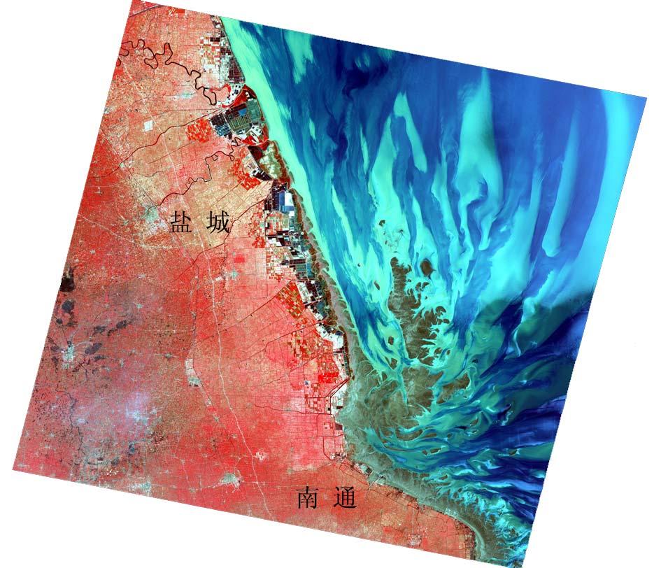
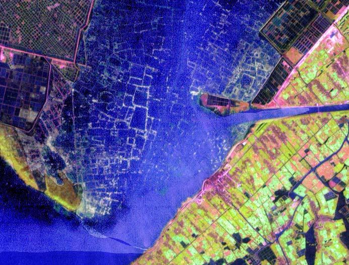
5 Dynamic variation of water body in Qinghai MSS TM 中巴
6 Water depth measurement 1) Within 15m 2) Lower suspended sediment concentration Absolute error is less than 1m.
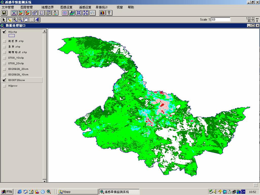
7
8
9
10
11
12
13 (2) Drought monitoring, warning and forecasting
14 Operational system in Helongjiang Province, North-east China Method used: Spatial model of characteristics on vegetal index and surface temperature Empirical model of thermal inertia method with vegetal index and temperature difference

15 1) Spatial model of characteristics on vegetal index and surface temperature
16 Space characteristic parameter 温度 60 T 30 T D = b 1 + b 2 * NDVI RSM D = a 1 + a 2 * σ RSM Arid T W NDVI RSM W Wet 植被指数
17 Calibration Calculation Ground obs.
18 RSM W RSM = LST LST W RSM W RSM D LST D LST W RSM = RSM W LST LST D LST W LST W [ RSM RSM ] W D
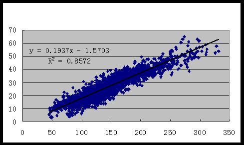
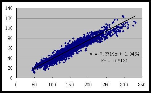
19
20 Error Analysis Observed value 安达巴彦宝清方正富锦富裕哈尔滨海伦虎林集贤. RMSE
21 2) Empirical model of thermal inertia method with vegetal index and temperature difference Data S = f Δ, w ( T NDVI ) Model for each month
22 ω = ω = a * Δ T + ω = a + b ΔT + ω = ω ω = = a * e Model selection ( b ( ΔT + c* NDVI )) NDVI k NDVI k a + b * ΔT + c * b ( ΔT c NDVI) a + b * ln + * a + b* NDVI+ c* NDVI+ d ( ΔT ) ω = NDVI a + b * NDVI ( ΔT ) ( ΔT ) a+ b* ω = NDVI+ d
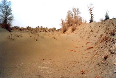
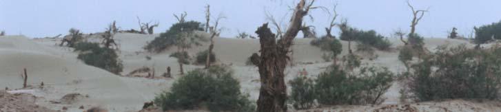
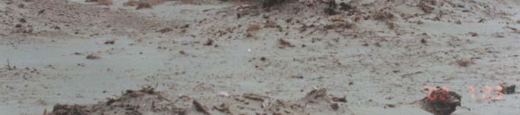
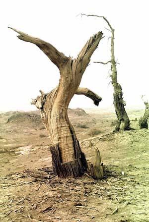
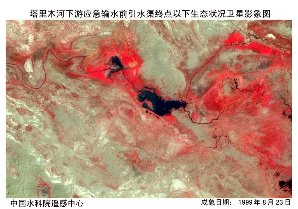
23 Models for drought forecasting Xinanjiang model Dry season without significant precipitation Leading time is ten days Artificial neural network model Real-time correction once five days
24 Yes Model for Evapotranspiration WU >EM k E pan EU 0 ED EL WU-EU WU Yes No WU EU 0 WU (k E pan -EU) WL/WLM EL WL-EL WL 0 ED WL >C WLM WL >C (k E pan -EU) 是 No C (k E pan -EU) EL WL-EL WL 0 ED No WL EL 0 WL C (k E pan -EU)-EL ED WD-ED WD WL-EL WL 0 ED EU+EL+ED E WU+WL+WD W
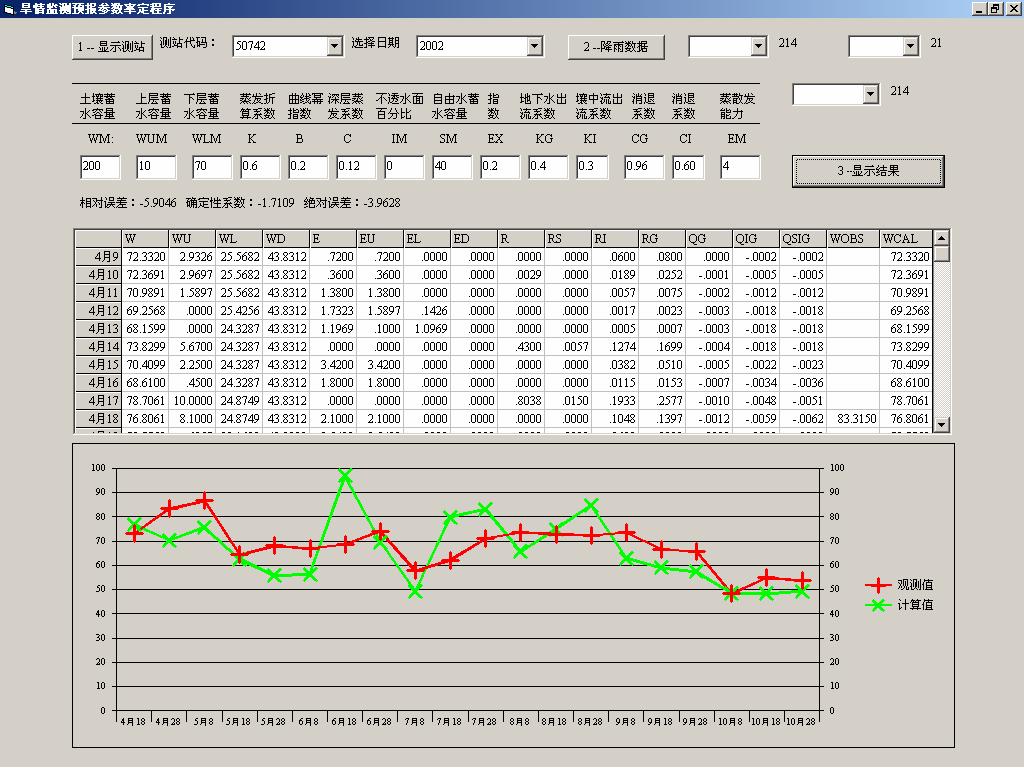
25 Calibration of model
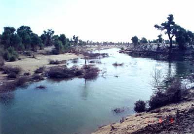
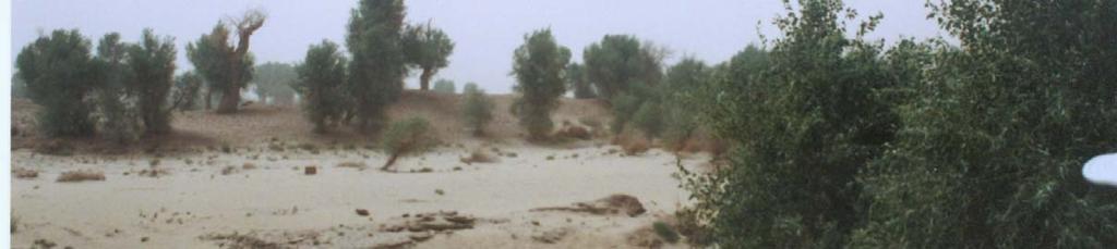
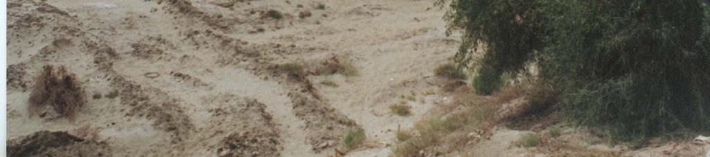
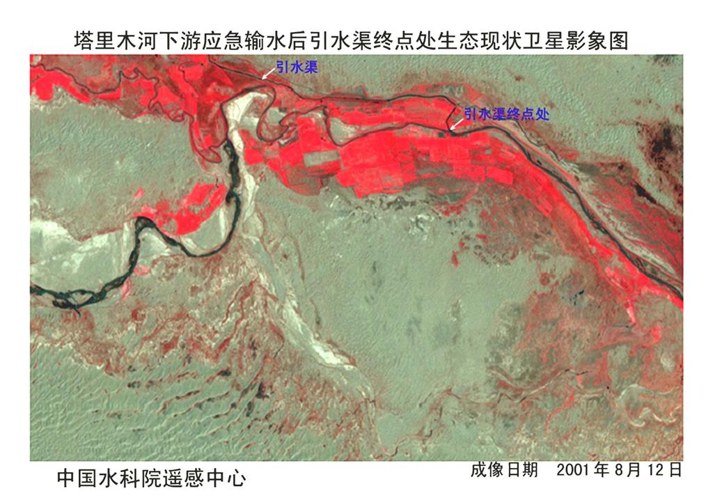
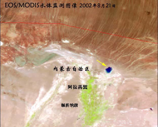
26 Validation and error analysis Station 克山 Date Cal. Obs. Relative Error Qualified 4 月 月 月 月 月 月 月 月 月 月 月 月 月 月
27
28 With these information, and also the distribution of crops and water demand during corresponding growth period, decision for drought relief can be made, namely, from where and when to divert how much water to mitigate drought situation.
29 (3)Dynamic monitoring of ecology and estimation of water demand for ecology
30 Image of the Talimo Basin
31

32
33 Water diversion to downstream of the Talimo River
34 It was a serious problem that water demand for ecology had not been considered in water resources distribution.

35 下游 363km 河道
36

37
38
39
40 NDVI 2000 年 2001 年 2002 年 2003 年 2004 年 2005 年 2006 年 离河距离 250m 500m 750m 1000m 1250m 1500m 1750m 2000m
41 NDVI 2000 年 ETM-NDVI 2002 年 ETM-NDVI 2004 年 ASTER-NDVI 2006 年 ASTER-NDVI 离河距离 m 750m 1000m 1250m 1500m 1750m 2000m
42
43 (4)Irrigation area investigation and development planning
44 In order to contend water, irrigation area is blindly developed in some places. It results in water shortage in downstream basin. In order to realize comprehensive management of water resources for the whole basin, irrigation area is an important and basic information.
45 Irrigation planning can be done on the basis of GIS-based database including water body, precipitation, soil, groundwater table, temperature, topography, runoff, water quality of groundwater. After weighting different factor separately, the place suitable for developing irrigation can be optimally selected.

46
47 (5)Monitoring of salinisation
48

49 Map of classification of in 2001
50 The spectrum curve in Ku-Xin-Sha and Yu-tian County
51 (6) Water environment monitoring
52

53 Blue alga Monitoring for the Taihu Lake

54 September 7, 8, 9 10 in 2007
55 Remote sensing is very effective for monitoring blue and green alga due to eutrophication in lakes and reservoirs and red tide along the coastal area.
56 (7) Planning, construction and management of water project
57
58
59 Remote sensing is the major source of data and information to GIS-based database, the spatial analysis and on-line virtual reality technology can play their important role on this basis.
60 (8)Determination of parameters for hydrological model
61 Xinanjiang Rainfall-runoff Watershed Model Input W 0 P EM B WM IMP Output Pervious Imperv. A RIM UH QRS W t ET RS EU WUM W W u S SM EX KSS RSS UH QRSS Q EL ED WLM WDM W l W d KG RG UH QRG
62 Model Parameters
63 Among 16 parameters in total, 7 parameters (WM, SM, B, CS, IMP, KS, EX ) can be determined directly or Indirectly by remote sensing and GIS.

64 Hydrological Modeling Model Validation in 2004

65 Hydrological Modeling Model Validation in 2005
66 (9) Real-time monitoring and management system of water resources
67 System consists of four sub-systems, data acquisition, data transmission, data processing decision-making support system ( DSS ).
68 The function of the system inquiry Statistics Prediction and warning WebGIS Planning Consultation Virtual simulation and audio-visual and threedimensional display Synthetic regional analysis
69 Conclusion 1)Through long-term practice in China, it can be seen that remote sensing can play an important role to water resources management. 2)It is very helpful to apply remote sensing technology together with GIS, GPS and conventional measures. 3)High resolution and high spectrum are necessary for solving some issues, such as quantitative determination of chemical elements in water body by remote sensing.
70 Dragon project is a cooperative project between NRSCC and ESA, one of subjects is application of remote sensing and other space technology to hydrology and water resources
71 Seven topics 1. Water Resources Assessment and Management Based on Water Cycle in Upper Yangtze River: A Case Study of Hengjiang River basin
72 2. Impacts of Land Use/Cover on Hydrological Alteration in Karst Basin of the Upper Yangtze River, China 3. Hydrological Response Simulation of Land Cover Change in Plain River Networks areas: A case of Taihu Basin 4. ERS SAR and Data for Storm Surge Hazards Mapping and Risk Management
73 5. Internet-Based System for Regional Soil Moisture Monitoring and Prediction Using Remote Sensing, Land Surface Models and Data Assimilation-A Prototype System for Drought Monitoring and Prediction in Xinjiang, China 6. Remote Sensing for Wetlands Monitoring in China 7. Study on the monitoring and prediction of rainstorms and floods with the combined use of satellite remote sensing and nonlinear science
74 Thanks for Your Attention
Satellite data and hydrological model to asses water quantity and quality in the Yangtze river basin, ID Third year activity
 Satellite data and hydrological model to asses water quantity and quality in the Yangtze river basin, ID 10664 Third year activity Marco Mancini1; Jiren Li2; Chiara Corbari1 Antonio Di Trapani ; Jinfeng
Drought Indicators for the SADC
 Drought Indicators for the SADC Bruce Eady DHI-SA Annual Conference Coping with Drought: Adaptions to Water Stress in the Face of Climate Change Agenda Introduction Satellite Data Drought and Flood Portal
题目 :XXXXXXXXXXXXXXXX. Application of Remote Sensing and GIS on Flood Monitoring and Assessment in China 天津大学 XX 毕业答辩
 中国水利水电科学研究院 China Institute of Water Resources & Hydropower R 天津大学 XX 毕业答辩 题目 :XXXXXXXXXXXXXXXX Application of Remote Sensing and GIS on Flood Monitoring and Assessment in China Pr. HUANG Shifeng China
WASA Quiz Review. Chapter 2
 WASA Quiz Review Chapter 2 Question#1 What is surface runoff? part of the water cycle that flows over land as surface water instead of being absorbed into groundwater or evaporating Question #2 What are
Lessons learned and improved technologies for real-time Flood Forecasting and Warning
 Lessons learned and improved technologies for real-time Flood Forecasting and Warning Jacob Høst-Madsen, Michael B. Butts, Claus Skotner, Henrik Madsen, Henrik Garsdal River & Flood Management Department
Introduction of Chinese Cooperation Initiatives on Scientific Research under CEWP. Sun Yan Research Coordinator, MWR 20 June, 2013 Brussels
 Introduction of Chinese Cooperation Initiatives on Scientific Research under CEWP Sun Yan Research Coordinator, MWR 20 June, 2013 Brussels Contents Background Chinese Initiatives Summary of Chinese Initiatives
Water Data Needs and Applications in the Private Sector. Robert Annear, Vice President, Ph.D., P.E. Water is our nature
 Water Data Needs and Applications in the Private Sector Robert Annear, Vice President, Ph.D., P.E. Water is our nature GRN Forum: Global Water - 2010 and Beyond Oct 21 2010 - Oct 22 2010 Introduction Our
Note that the Server provides ArcGIS9 applications with Spatial Analyst and 3D Analyst extensions and ArcHydro tools.
 Remote Software This document briefly presents the hydrological and hydraulic modeling software available on the University of Nice Server with Remote Desktop Connection. Note that the Server provides
A Study of Himreen Reservoir Water Quality Using in Situ Measurement and Remote Sensing Techniques
 A Study of Himreen Reservoir Water Quality Using in Situ Measurement and Remote Sensing Techniques Dr. Salah A. H. Saleh College of Science, Nahrain University, Baghdad - IRAQ Abstract The use of remote
Monitoring, Assessment, Prediction and Meteorological service of Agricultural Drought in China
 Monitoring, Assessment, Prediction and Meteorological service of Agricultural Drought in China Wang Shili China Meteorological Administration January, 2005, Kobe Content Characteristics of agrometerological
Lecture 9A: Drainage Basins
 GEOG415 Lecture 9A: Drainage Basins 9-1 Drainage basin (watershed, catchment) -Drains surfacewater to a common outlet Drainage divide - how is it defined? Scale effects? - Represents a hydrologic cycle
Use of GIS and Remote Sensing to assess Soil Erosion in Arid to Semiarid Basin in Jordan
 Use of GIS and Remote Sensing to assess Soil Erosion in Arid to Semiarid Basin in Jordan Ibrahim Farhan and Jawad Al Bakri Dept. Land, Water & Env. Faculty of Agriculture, University of Jordan, Amman,
Flood forecasting model based on geographical information system
 192 Remote Sensing and GIS for Hydrology and Water Resources (IAHS Publ. 368, 2015) (Proceedings RSHS14 and ICGRHWE14, Guangzhou, China, August 2014). Flood forecasting model based on geographical information
Flood forecasting model based on geographical information system
 doi:10.5194/piahs-368-192-2015 192 Remote Sensing and GIS for Hydrology and Water Resources (IAHS Publ. 368, 2015) (Proceedings RSHS14 and ICGRHWE14, Guangzhou, China, August 2014). Flood forecasting model
Simulation of soil moisture for typical plain region using the Variable Infiltration Capacity model
 doi:10.5194/piahs-368-215-2015 Remote Sensing and GIS for Hydrology and Water Resources (IAHS Publ. 368, 2015) (Proceedings RSHS14 and ICGRHWE14, Guangzhou, China, August 2014). 215 Simulation of soil
Water Resources CHOIR in China
 Water Resources CHOIR in China Strategic research and innovation priorities for water Liu Dengwei 水利部发展研究中心 Development Research Center of the Ministry of Water Resources of China Water Resources CHOIR
Event and Continuous Hydrological Modeling with HEC- HMS: A Review Study
 Event and Continuous Hydrological Modeling with HEC- HMS: A Review Study Sonu Duhan *, Mohit Kumar # * M.E (Water Resources Engineering) Civil Engineering Student, PEC University Of Technology, Chandigarh,
1 THE USGS MODULAR MODELING SYSTEM MODEL OF THE UPPER COSUMNES RIVER
 1 THE USGS MODULAR MODELING SYSTEM MODEL OF THE UPPER COSUMNES RIVER 1.1 Introduction The Hydrologic Model of the Upper Cosumnes River Basin (HMCRB) under the USGS Modular Modeling System (MMS) uses a
3/1/18 USING RADAR FOR WETLAND MAPPING IMPORTANCE OF SOIL MOISTURE TRADITIONAL METHODS TO MEASURE SOIL MOISTURE. Feel method Electrical resistance
 3/1/18 USING RADAR FOR WETLAND MAPPING SOIL MOISTURE AND WETLAND CLASSIFICATION Slides modified from a presentation by Charlotte Gabrielsen for this class. Southeast Arizona: Winter wet period From C.
Water Development and Management Strategy of China
 Water Development and Management Strategy of China Li Yuanyuan Deputy Chief Engineer, General Institute of Water Resources and Hydropower Planning and Design General Institute, MWR Abstract: Water is not
HYDROLOGICAL MODELING OF AN AGRICULTURAL WATERSHED USING HEC-HMS HYDROLOGICAL MODEL, REMOTE SENSING AND GEOGRAPHICAL INFORMATION SYSTEM
 HYDROLOGICAL MODELING OF AN AGRICULTURAL WATERSHED USING HEC-HMS HYDROLOGICAL MODEL, REMOTE SENSING AND GEOGRAPHICAL INFORMATION SYSTEM Niravkumar K. Pampaniya 1, Mukesh K. Tiwari 2, M. L. Gaur 3 1 M.Tech.
Building climate resilience
 Public Disclosure Authorized Public Disclosure Authorized Public Disclosure Authorized THE NILE STORY BRIEFING NOTE 3 102249 Building climate resilience Climate change is a critical issue facing the countries
USE OF GABIONS IN SMALL HYDRAULIC WORKS
 USE OF GABIONS IN SMALL HYDRAULIC WORKS SECTION 1 SITE SELECTION FOR SMALL DAMS Table of Contents 1.1 CLASSIFICATION ACCORDING TO USE... 2 1.2 CLASSIFICATION BY HYDRAULIC DESIGN (site and basin requirements)...2
HyMeX (*) WG2: Hydrological Continental Cycle. I. Braud (1), A. Chanzy (2) *Hydrological cycle in the Mediterranean experiment
 WG2: Hydrological Continental Cycle. I. Braud (1), A. Chanzy (2) *Hydrological cycle in the Mediterranean experiment") HyMeX (*) http://www.hymex.org/ WG2: Hydrological Continental Cycle I. Braud (1), A. Chanzy (2) (1) CEMAGREF, UR HHLY, Lyon, France (2) UME EMMAH, INRA, Avignon, France *Hydrological cycle in the Mediterranean
HyMeX (*) http://www.hymex.org/ WG2: Hydrological Continental Cycle I. Braud (1), A. Chanzy (2) (1) CEMAGREF, UR HHLY, Lyon, France (2) UME EMMAH, INRA, Avignon, France *Hydrological cycle in the Mediterranean
Suspended Sediment Discharges in Streams
 US Army Corps of Engineers Hydrologic Engineering Center Suspended Sediment Discharges in Streams April 1969 Approved for Public Release. Distribution Unlimited. TP-19 REPORT DOCUMENTATION PAGE Form Approved
Role of Remote Sensing in Flood Management
 Role of Remote Sensing in Flood Management Presented by: Victor Veiga (M.Sc Candidate) Supervisors: Dr. Quazi Hassan 1, and Dr. Jianxun He 2 1 Department of Geomatics Engineering, University of Calgary
Earth observations for water resource management: Current practice and examples
 Earth observations for water resource management: Current practice and examples NEW OPPORTUNITIES IN SATELLITE AND AIRBORNE REMOTE SENSING: Hydrological and Environmental Applications DTU Environment Lyngby
Remote Sensing Monitoring of Vector-borne Disease
 Remote Sensing Monitoring of Vector-borne Disease Malaria Project ID: 10515 C-PI: Prof. Chuan-rong Li Team members: Hong-bing Niu, Ling-li Tang, Zhao-yan Liu Key Laboratory of Quantitative Remote Sensing
Simulation of Daily Streamflow
 US Army Corps of Engineers Hydrologic Engineering Center Simulation of Daily Streamflow April 1968 Approved for Public Release. Distribution Unlimited. TP-6 REPORT DOCUMENTATION PAGE Form Approved OMB
Chung-Gil Jung, Ph.D.
 Chung-Gil Jung, Ph.D. Postdoctoral Associate (Focus: Data Sciences and Water Resources Engineering) Texas A&M AgriLife Center at El Paso 1380 A&M Circle, El Paso, Texas 79927-5020, USA Office: Tel 915-859-9111
STUDY ON SOIL MOISTURE BY THERMAL INFRARED DATA
 THERMAL SCIENCE, Year 2013, Vol. 17, No. 5, pp. 1375-1381 1375 STUDY ON SOIL MOISTURE BY THERMAL INFRARED DATA by Jun HE a, Xiao-Hua YANG a*, Shi-Feng HUANG b, Chong-Li DI a, and Ying MEI a a School of
Hydrostatistics Principles of Application
 US Army Corps of Engineers Hydrologic Engineering Center Hydrostatistics Principles of Application July 1969 Approved for Public Release. Distribution Unlimited. TP-15 REPORT DOCUMENTATION PAGE Form Approved
Hypothetical Flood Computation for a Stream System
 US Army Corps of Engineers Hydrologic Engineering Center Hypothetical Flood Computation for a Stream System December 1968 Approved for Public Release. Distribution Unlimited. TP-12 REPORT DOCUMENTATION
The role of Remote Sensing in Irrigation Monitoring and Management. Mutlu Ozdogan
 The role of Remote Sensing in Irrigation Monitoring and Management Mutlu Ozdogan Outline Why do we care about irrigation? Remote sensing for irrigated agriculture What are the needs of irrigators? Future
Data and tools for climate change vulnerability assessments
 Data and tools for climate change vulnerability assessments Workshop on data collection and water balances, Armenia Johannes Hunink Peter Droogers Sep-2016, Yerevan FutureWater > Research and consulting
CRYOSPHERE & HYDROLOGY
 CRYOSPHERE & HYDROLOGY M.Menenti, X. LI, J. WANG, H. Vereecken, Jiren LI, M. Mancini, Q.LIU, L.JIA, Jing LI, C.Kuenzer, S. HUANG, H.Yesou, J.WEN, Y. Kerr, X. CHENG, N. Gourmelen, C. KE, R.Ludwig, H. LIN,
Analyzing the Changes to the Hydrologic Cycle. with the Implementation of LID Techniques in Korea
 Analyzing the Changes to the Hydrologic Cycle with the Implementation of LID Techniques in Korea Jung Min Lee Contents 1 Introduction 2 Change of New City Paradigm on Korea 3 Case Study 4 The Effects of
Pilot Study for Storage Requirements for Low Flow Augmentation
 US Army Corps of Engineers Hydrologic Engineering Center Pilot Study for Storage Requirements for Low Flow Augmentation April 1968 Approved for Public Release. Distribution Unlimited. TP-7 REPORT DOCUMENTATION
Estimation of Infiltration Parameter for Tehri Garhwal Catchment
 Estimation of Infiltration Parameter for Tehri Garhwal Catchment Ashish Bhatt 1 H L Yadav 2 Dilip Kumar 3 1 UG Student, Department of civil engineering, G B Pant Engineering College, Pauri, UK-246194 2,3
Physically-based distributed modelling of river runoff under changing climate conditions
 156 Remote Sensing and GIS for Hydrology and Water Resources (IAHS Publ. 368, 2015) (Proceedings RSHS14 and ICGRHWE14, Guangzhou, China, August 2014). Physically-based distributed modelling of river runoff
Alternative Approaches to Water Resource System Simulation
 US Army Corps of Engineers Hydrologic Engineering Center Alternative Approaches to Water Resource System Simulation May 1972 Approved for Public Release. Distribution Unlimited. TP-32 REPORT DOCUMENTATION
Latest tools and methodologies for flood modeling
 Latest tools and methodologies for flood modeling Dr. Yuri Simonov Senior scientist, Hydrometcentre of Russia WMO Commission for Hydrology AWG member Floods - background Types of water-related natural
MODULE 8 LECTURE NOTES 5 REMOTE SENSING APPLICATIONS IN DROUGHT ASSESSMENT
 MODULE 8 LECTURE NOTES 5 REMOTE SENSING APPLICATIONS IN DROUGHT ASSESSMENT 1. Introduction Drought is a phenomenon of long-term moisture deficiency. It may be meteorological, agricultural or hydrologic
CGIAR Research Program on Water, Land and Ecosystems: Use of remote sensing and GIS tools in the irrigation commands to assist planning and management
 CGIAR Research Program on Water, Land and Ecosystems: Use of remote sensing and GIS tools in the irrigation commands to assist planning and management Summary Remote sensing (RS) and geographic information
Physically-based distributed modelling of river runoff under changing climate conditions
 doi:10.5194/piahs-368-156-2015 156 Remote Sensing and GIS for Hydrology and Water Resources (IAHS Publ. 368, 2015) (Proceedings RSHS14 and ICGRHWE14, Guangzhou, China, August 2014). Physically-based distributed
CHAPTER ONE : INTRODUCTION
 CHAPTER ONE : INTRODUCTION WHAT IS THE HYDROLOGY? The Hydrology means the science of water. It is the science that deals with the occurrence, circulation and distribution of water of the earth and earth
GIS Framework to Evaluate Impact of Climate Change on Water Resources
 GIS Framework to Evaluate Impact of Climate Change on Water Resources Dr. Nagraj S. Patil A. K. Gosain, Professor Civil Engineering Department I. I. T. Delhi Objectives of the Study To Develop portal to
The Spatial Analysis between SWAT Simulated Soil Moisture, and MODIS LST and NDVI Products
 Konkuk University, Seoul, South Korea The Spatial Analysis between SWAT Simulated Soil Moisture, and MODIS LST and NDVI Products Geun Ae PARK Post-doctoral Researcher, Dept. of Civil and Environmental
Maintaining healthy rivers and lakes through water diversion from Yangtze River to Taihu Lake in Taihu Basin
 Water Science and Engineering, Sep. 2008, Vol. 1, No. 3, 36-43 ISSN 1674-2370, http://kkb.hhu.edu.cn, e-mail: wse@hhu.edu.cn Maintaining healthy rivers and lakes through water diversion from Yangtze River
Application of the PRMS model in the Zhenjiangguan watershed in the Upper Minjiang River basin
 doi:10.5194/piahs-368-209-2015 Remote Sensing and GIS for Hydrology and Water Resources (IAHS Publ. 368, 2015) (Proceedings RSHS14 and ICGRHWE14, Guangzhou, China, August 2014). 209 Application of the
System Dynamics Modeling for Sustainable Water Management of a Coastal Area in Shandong Province, China
 Journal of Earth Science and Engineering 4 (2016) 226-234 doi: 10.17265/2159-581X/2016.04.005 D DAVID PUBLISHING System Dynamics Modeling for Sustainable Water Management of a Coastal Area in Shandong
Computer Determination of Flow Through Bridges
 US Army Corps of Engineers Hydrologic Engineering Center Computer Determination of Flow Through Bridges July 1970 Approved for Public Release. Distribution Unlimited. TP-20 REPORT DOCUMENTATION PAGE Form
LARGE SCALE SOIL MOISTURE MODELLING
 Soil Moisture Workshop LARGE SCALE SOIL MOISTURE MODELLING Giuseppe Formetta, Vicky Bell, and Eleanor Blyth giufor@nerc.ac.uk Centre for Ecology and Hydrology, Wallingford, UK Wednesday 25 th January 2017
DEVELOPMENT OF A DECISION SUPPORT SYSTEM FOR NATURAL DAMAGE ASSESSMENT BASED ON REMOTE SENSING AND BIO-PHYSICAL MODELS
 DEVELOPMENT OF A DECISION SUPPORT SYSTEM FOR NATURAL DAMAGE ASSESSMENT BASED ON REMOTE SENSING AND BIO-PHYSICAL MODELS M.A. Sharifi a*, W.G.M. Bastiaanssen b, S.J. Zwart b a ITC, P.O. Box 6, 7500 AA, Enschede,
Yangtze River Economic Zone and Adaptation to Climate Change
 Water and Climate : meetings of the great rivers of the world International Summit Yangtze River Economic Zone and Adaptation to Climate Change CHEN Jin Changjiang River Scientific Research Institute (CRSRI)
Forecast Informed Reservoir Operations (FIRO) ERDC Hydrologic Investigations
 ERDC Hydrologic Investigations") Forecast Informed Reservoir Operations (FIRO) ERDC Hydrologic Investigations Briefing, May 31, 2017 Background The US Army Corps of Engineers (USACE) operates reservoirs primarily for flood control, with
Forecast Informed Reservoir Operations (FIRO) ERDC Hydrologic Investigations Briefing, May 31, 2017 Background The US Army Corps of Engineers (USACE) operates reservoirs primarily for flood control, with
Reservoir on the Rio Boba
 Reservoir on the Rio Boba Michael J. Burns II Guillermo Bustamante J. James Peterson Executive Summary The National Institute of Water Resources in the Dominican Republic (INDRHI) plans to construct a
Managed Aquifer Recharge (MAR) Practical Techniques for the Caribbean
 Practical Techniques for the Caribbean") Managed Aquifer Recharge (MAR) Practical Techniques for the Caribbean Scope of Presentation What is MAR? Antigua and Barbuda water resources issues Why promote MAR? MAR: Techniques MAR: Design criteria
Managed Aquifer Recharge (MAR) Practical Techniques for the Caribbean Scope of Presentation What is MAR? Antigua and Barbuda water resources issues Why promote MAR? MAR: Techniques MAR: Design criteria
global science solutions
 global science solutions Tim Martin: Riverside Technology, inc. Fort Collins, Colorado, USA 2.4: Water Security Information and Tools to Support Global Water Security International Symposium on Synergistic
1. WATER QUALITY SIMULA TION DOWNSTREAM OF THE DONG JIANG RIVER... I-1 2. NEW TREND AND APPLICATION OF RUNOFF ANALYSIS... I-4
 CONTENTS INLAND 1. WATER QUALITY SIMULA TION DOWNSTREAM OF THE DONG JIANG RIVER... I-1 2. NEW TREND AND APPLICATION OF RUNOFF ANALYSIS.... I-4 3. CURRENT STATUS AND DEVELOPMENT TREND OF POLLUTION LOAD
CE 2031 WATER RESOURCES ENGINEERING L T P C
 CE 2031 WATER RESOURCES ENGINEERING L T P C 3 0 0 3 QUESTION BANK PART - A UNIT I GENERAL 1. Write short notes on Water Resources Survey. 2. How do you calculate Average Annual Runoff depth? 3. Write short
Soil & Climate Anne Verhoef
 Soil Research Centre Anne Verhoef December 12, 2014 University of Reading 2014 www.reading.ac.uk Overview Aim: Improve understanding of soil-plant-atmosphere feedbacks for sustainable soil services Selection
Disaster Early Warning and Response Activities at RCMRD Tesfaye Korme (Ph.D), Regional Centre for Mapping of Resources for Development
, Regional Centre for Mapping of Resources for Development") Satellite Earth Observation & Disaster Risks Disaster Early Warning and Response Activities at RCMRD Tesfaye Korme (Ph.D), Regional Centre for Mapping of Resources for Development RCMRD and its member
Satellite Earth Observation & Disaster Risks Disaster Early Warning and Response Activities at RCMRD Tesfaye Korme (Ph.D), Regional Centre for Mapping of Resources for Development RCMRD and its member
IMPACT OF HYDROELECTRIC DEVELOPMENT OF THE UPPER REACHES OF IRRAWADDY RIVER ON THE LOWER REACHES
 IMPACT OF HYDROELECTRIC DEVELOPMENT OF THE UPPER REACHES OF IRRAWADDY RIVER ON THE LOWER REACHES Reporter: Ma Jianwei China Institute of Water Resource and Hydropower Research 22 Feb 2018 http://www.iwhr.com/iwhr-english/index.htm
Integrated hydrological modeling to support basin-scale water resources management
 Integrated hydrological modeling to support basin-scale water resources management Yi Zheng (zhengy@sustc.edu.cn) School of Environmental Science and Engineering Southern University of Science and Technology,
Remote sensing applications in natural resources mapping and management An Indian Context
 Remote sensing applications in natural resources mapping and management An Indian Context International Workshop on Operational Mapping/Monitoring of Agricultural Crops in South/Southeast Asian Countries
INTRODUCTION TO THE BREAKOUT SESSIONS. ESA-FAO-GWSP Workshop on WEF Rome, Italy March 25, 2014 Richard Lawford Cat Downy, Lucie Pluschke
 INTRODUCTION TO THE BREAKOUT SESSIONS ESA-FAO-GWSP Workshop on WEF Rome, Italy March 25, 2014 Richard Lawford Cat Downy, Lucie Pluschke The Breakout Groups are a critical element in the Workshop structure
Remote Sensing of Water Resources
 Remote Sensing of Water Resources National Disaster Management Institute Yoomi Hur Climate Change Hydrologic Cycle Hydrologic Indices Soil Moisture Evaportranspiration Drought Conclusions 3 The water cycle
Control and mitigation of floods along transbasin diversion channel of Mekong tributaries and Nan river, Thailand
 Control and mitigation of floods along transbasin diversion channel of Mekong tributaries and Nan river, Thailand Tawatchai Tingsanchali* School of Civil Engineering, Asian Institute of Technology, P.O.Box
Drought Risk Management Activities in Iranian Space Agency Using Space Technology
 Drought Risk Management Activities in Iranian Space Agency Using Space Technology ABDOLREZA ANSARI AMOLI Remote Sensing & GIS Department Iranian Space Agency (ISA) 21th Intergovernmental Consultative Committee
ACTIVITY LIST. Integrated Drought Management in Central and Eastern Europe 1. BASIC INFORMATION. Number of Activity: 5.5
 Integrated Drought Management in Central and Eastern Europe ACTIVITY LIST 1. BASIC INFORMATION Number of Activity: 5.5 Title of the activity: Policy oriented study on remote sensing agricultural drought
Crop Growth Monitor System with Coupling of AVHRR and VGT Data 1
 Crop Growth Monitor System with Coupling of AVHRR and VGT Data 1 Wu Bingfng and Liu Chenglin Remote Sensing for Agriculture and Environment Institute of Remote Sensing Application P.O. Box 9718, Beijing
CHANGES ON FLOOD CHARACTERISTICS DUE TO LAND USE CHANGES IN A RIVER BASIN
 U.S.- Italy Research Workshop on the Hydrometeorology, Impacts, and Management of Extreme Floods Perugia (Italy), November 1995 CHANGES ON FLOOD CHARACTERISTICS DUE TO LAND USE CHANGES IN A RIVER BASIN
Modeling Status Update Review of Data and Documents
 SUSTAINABLE, JUST & PRODUCTIVE WATER RESOURCES DEVELOPMENT IN WESTERN NEPAL UNDER CURRENT & FUTURE CONDITIONS (DIGO JAL BIKAS DJB) Modeling Status Update Review of Data and Documents Tuesday, 1 ST August,
Modelling the impact of land use change on the water balance in the Xiangxi Catchment (Three Gorges Region, China) using SWAT
 using SWAT") Modelling the impact of land use change on the water balance in the Xiangxi Catchment (Three Gorges Region, China) using SWAT K. Bieger, B. Schmalz, Q. Cai, N. Fohrer 2010 International SWAT Conference
Modelling the impact of land use change on the water balance in the Xiangxi Catchment (Three Gorges Region, China) using SWAT K. Bieger, B. Schmalz, Q. Cai, N. Fohrer 2010 International SWAT Conference
A comparative study of the methods for estimating streamflow at ungauged sites
 22nd International Congress on Modelling and Simulation, Hobart, Tasmania, Australia, 3 to 8 December 2017 mssanz.org.au/modsim2017 A comparative study of the methods for estimating streamflow at ungauged
TECHNICAL SUMMARY IEM. Integrated Environmental Monitoring
 TECHNICAL SUMMARY IEM Integrated Environmental Monitoring June 24 APEIS-IEM Technical Summary 1. What is APEIS-IEM? Rapid population growth and economic development in the Asia Pacific region has resulted
Study of Hydrology based on Climate Changes Simulation Using SWAT Model At Jatiluhur Reservoir Catchment Area
 Study of Hydrology based on Climate Changes Simulation Using SWAT Model At Jatiluhur Reservoir Catchment Area Budi Darmawan Supatmanto 1, Sri Malahayati Yusuf 2, Florentinus Heru Widodo 1, Tri Handoko
Global health and climate change.
 Global health and climate change simon.hales@otago.ac.nz Outline Causals pathways of global change and human health: climate change is THE issue Outline Causals pathways of global change and human health:
Radar-based flood forecasting: Quantifying hydrologic prediction uncertainty
 Severe Storms Prediction and Global Climate Impact on the Gulf Coast, Rice University, October 29 31, 2008 Radar-based flood forecasting: Quantifying hydrologic prediction uncertainty Baxter E. Vieux,
Water Resources ENV 107
 Water Resources ENV 107 Freshwater is an irreplaceable Resource Access to water is A global health issue An economic issue A women s and children s issue A national and global security issue Most of the
Using the DEM-based Xin'anjiang hydrologic model to simulate hydrologic characteristics in SiheRiver Basin
 IOP Conference Series: Earth and Environmental Science PAPER OPEN ACCESS Using the DEM-based Xin'anjiang hydrologic to simulate hydrologic characteristics in SiheRiver Basin To cite this article: C S Qi
Impact of Climate Change on Water Resources of a Semi-arid Basin- Jordan
 Impact of Climate Change on Water Resources of a Semi-arid Basin- Jordan Prof. Fayez Abdulla Civil Engineering Department Jordan University of Science & Technology Presented at the Water in an Arid Land,
Long-term forecasting of natural disasters under projected climate changes in Ukraine
 Scientific Centre for Aerospace Research of the Earth National Academy of Sciences of Ukraine 55-b, O. Honchar street, Kiev, 01601, Ukraine phone/fax: (+38 044) 486 1148 URL: www.casre.kiev.ua; Е-mail:
Earth Observation in support for project identification/preparation
 Asian Water Forum Oct. 5th 2018 Asian Development Bank Manila, Philippines Earth Observation in support for project identification/preparation Christian Tottrup, DHI GRAS EO4SD -> Background Water plays
Hydrology and Water Management. Dr. Mujahid Khan, UET Peshawar
 Hydrology and Water Management Dr. Mujahid Khan, UET Peshawar Course Outline Hydrologic Cycle and its Processes Water Balance Approach Estimation and Analysis of Precipitation Data Infiltration and Runoff
Climate Change Water Implications for Michigan Communities, Landsystems and Agriculture
 Climate Change Water Implications for Michigan Communities, Landsystems and Agriculture Distinguished Senior Research Specialist Department of Geography Institute of Water Research Climate Change Summary
The Impact of Climate Change on Surface and Groundwater Resources and their Management. I Concepts, Observations, Modeling.
 The Impact of Climate Change on Surface and Groundwater Resources and their Management I Concepts, Observations, Modeling Manfred Koch Department of Geohydraulics and Engineering Hydrology, University
Application of SWAT Model in land-use. change in the Nile River Basin: A Review
 Application of SWAT Model in land-use change in the Nile River Basin: A Review By: Marwa Ali, Okke Batelaan and Willy Bauwens 15-6-2011 Application of SWAT Model in land-use 1 change in the Nile River
Worldwide Exchange of Water Data
 Worldwide Exchange of Water Data Fernando R. Salas and David R. Maidment Center for Research in Water Resources University of Texas at Austin 2014 AWRA Spring Specialty Conference: GIS and Water Resources
Guided by WMO-134 ( Guide to Agricultural Meteorological Practices (GAMP) 2007 completely revised version) Sistana SCADA Systems Ltd.
 2007 completely revised version) Sistana SCADA Systems Ltd.") Agricultural Decision Support System Guided by WMO-134 ( Guide to Agricultural Meteorological Practices (GAMP) 2007 completely revised version) Sistana SCADA Systems Ltd. Agricultural Decision Support
Agricultural Decision Support System Guided by WMO-134 ( Guide to Agricultural Meteorological Practices (GAMP) 2007 completely revised version) Sistana SCADA Systems Ltd. Agricultural Decision Support
Rationally Utilizing Water Resources to Control Soil Salinity in Irrigation Districts
 This paper was peer-reviewed for scientific content. Pages 1134-1138. In: D.E. Stott, R.H. Mohtar and G.C. Steinhardt (eds). 2001. Sustaining the Global Farm. Selected papers from the 10th International
HYDROLOGY WORKSHEET 1 PRECIPITATION
 HYDROLOGY WORKSHEET 1 PRECIPITATION A watershed is an area of land that captures rainfall and other precipitation and funnels it to a lake or stream or wetland. The area within the watershed where the
Stream hydrographs. Stream hydrographs. Baseflow. Graphs of river stage or discharge at a single location as a function of time
 Stream hydrographs Graphs of river stage or discharge at a single location as a function of time Hydrologic og budget Discharge: units? How is it measured? Show fluctuating water levels in response to
WHEN SPACE MEETS AGRICULTURE
 WHEN SPACE MEETS AGRICULTURE Image from ESA Sentinel 14-15 November 2016 Matera, Italy Join the conversation #WSMA16 What can Copernicus do for farmers and for the European Agricultural Policy Catharina
Assessment of Watershed Soundness by Water Balance Using SWAT Model for Han River Basin, South Korea
 2015 International SWAT Conference & Workshops October 12-16, 2015 Purdue University, USA SESSION A3: HYDROLOGY Room: Stewart 278 2015 International SWAT Conference Assessment of Watershed Soundness by
Role of Ministry of Energy and Water in National IWRM Planning
 Role of Ministry of Energy and Water in National IWRM Planning 4 th Beirut Water Week Technological Tools and Financing Mechanisms for IWRM: Complementing Hydro diplomacy & Climate Change Adaptation Efforts
Final Report of Activities carried out during the STM period at NIGLAS-CAS
 Programma STM - Short Term Mobility (Anno 215) -Paolo Villa [authorized with Prot. AMMCNT Num. 2422 of 9/4/215] Programma STM - Short Term Mobility (Anno 215), authorized with Prot. AMMCNT Num. 2422 of
Climate Change, Climate variability and Water Management
 Climate Change, Climate variability and Water Management Ainun Nishat Ph.D. Country Representative, Bangladesh IUCN, the International Union for Conservation of Nature From Water and Climate Change: IPCC
Climate change science, knowledge and impacts on water resources in South Asia
 Climate change science, knowledge and impacts on water resources in South Asia DIAGNOSTIC PAPER 1 GUILLAUME LACOMBE, PENNAN CHINNASAMY Regional Conference on Risks and Solutions: Adaptation Frameworks