Before the Minnesota Public Utilities Commission Docket No. PL-6668/PPL November 2013 Sandpiper Pipeline Project
|
|
|
- Anne Lawson
- 6 years ago
- Views:
Transcription


1 Before the Minnesota Public Utilities Commission Docket No. PL-6668/PPL November 2013 Sandpiper Pipeline Project
2 BEFORE THE MINNESOTA PUBLIC UTILITIES COMMISSION Beverly Jones Heydinger Chair Dr. David C. Boyd Commissioner Nancy Lange Commissioner J. Dennis O'Brien Commissioner Betsy Wergin Commissioner In the Matter of the Application of Enbridge Pipelines (North Dakota) LLC For a Pipeline Routing Permit for the Sandpiper Pipeline Project MPUC Docket No. PL-6668/PPL APPLICATION SUMMARY Enbridge Pipelines (North Dakota) LLC ( EPND ) 1 is proposing to construct a new 612-mile 24-inch and 30-inch diameter crude oil pipeline as part of its ongoing efforts to meet North America s needs for reliable and secure transportation of petroleum energy supplies. EPND is submitting an application for a pipeline routing permit from the Minnesota Public Utilities Commission pursuant to Minnesota Rule The project, known as the Sandpiper Pipeline Project ( Project or Sandpiper ), will transport Bakken and Three Forks crude oil from growing production regions in the Williston Basin 2 of eastern Montana and western North Dakota. The Project begins at EPND s Beaver Lodge Station, south of Tioga, North Dakota and extends to a new terminal facility to be constructed at Clearbrook, Minnesota, and then on to an Enbridge affiliate s terminal and tank farm facility in Superior, Wisconsin. From the Superior terminal, the crude oil volumes will be transported to other refining markets via the Enbridge Mainline System. Approximately 299 miles of the Project will cross Minnesota. The preferred route for the Project is co-located, to the extent practicable, with EPND s existing right-of-way or other third-party rights-of-way in Minnesota. The preferred route in Minnesota will traverse Polk, Red Lake, Clearwater, Hubbard, Cass, Crow Wing, Aitkin, and Carlton counties. In addition to the new pipeline, the Project involves adding a new terminal with two 150,000 barrel tanks and a new pump station near Clearbrook, Minnesota; mainline valves at major waterbody crossings and over the length of the preferred route; and Pipeline Inspection Gauge launcher and receiver traps along with one of the mainline valves at a site near Pine River, Minnesota. 1 Enbridge Pipelines (North Dakota) LLC, is a limited liability company duly organized under the laws of the State of Delaware and is referred to as EPND in this document. EPND is a wholly owned subsidiary of Enbridge Energy Partners, L.P. ("EEP") which is a Delaware master limited partnership. Enbridge Energy, Limited Partnership, a wholly owned subsidiary of EEP and an affiliate of Enbridge Inc., owns and operates the U.S. portion of the existing Enbridge Mainline System. Collectively, the affiliated entities excluding EPND are referred to as Enbridge in this document. 2 The Bakken formation is currently the largest contributor to the total crude oil production in the Williston Basin, the oil industry refers to all of the crude oil production in the Williston Basin as Bakken crude oil.
3 The Project s purpose is to transport growing supplies of oil produced in North Dakota to the terminals in Clearbrook, Minnesota and Superior, Wisconsin. From these terminals, the crude oil can be shipped on various other pipelines, ultimately providing refineries in Minnesota, other states in the Midwest and the East Coast with crude oil. The Project will provide up to 225,000 barrels per day of new crude oil capacity from North Dakota to meet the demand for safe and economical transportation capacity. 3 Pending regulatory approval by the Minnesota Public Utilities Commission, the Project would be in service in the first quarter of The Project is in the public interest because it provides the timely addition of incremental capacity necessary to connect the increasing Bakken production to refining centers in the Midwest and beyond. The Project s additional pipeline capacity will help alleviate the lack of crude oil pipeline infrastructure from the Williston Basin to premium refinery and marketing hubs, thereby serving the public interest by providing improved refinery access to an abundant, secure, and reliable source of crude oil supply. 3 The Project will have a capacity of 375,000 bpd between Clearbrook, Minnesota and Superior, Wisconsin. Total new capacity, however, is 225,000 bpd as the 150,000 bpd that will enter Sandpiper at Clearbrook is currently transported to Clearbrook on EPND s existing Line 81 and to Superior, Wisconsin on the Enbridge Mainline System.
4 Pipeline Routing Permit Application MPUC Docket No. PL-6668/PPL November 2013 SANDPIPER PIPELINE PROJECT TABLE OF CONTENTS Routing Permit GENERAL INFORMATION PROPOSED PIPELINE AND ASSOCIATED FACILITIES DESCRIPTION LAND REQUIREMENTS PROJECT EXPANSION RIGHT-OF-WAY PREPARATION PROCEDURES AND CONSTRUCTION ACTIVITY SEQUENCE PREFERRED ROUTE LOCATION; ENVIRONMENT DESCRIPTION ENVIRONMENTAL IMPACT OF PREFERRED ROUTE RIGHT-OF-WAY PROTECTION AND RESTORATION MEASURES OPERATION AND MAINTENANCE LIST OF GOVERNMENT AGENCIES AND PERMITS EVIDENCE OF CONSIDERATION OF ALTERNATIVE ROUTES
5 Pipeline Routing Permit Application MPUC Docket No. PL-6668/PPL November 2013 ACRONYMS AMA APP bbl bpd C.F.R. DWSMA EEP EIR EPA EPND EPP GIS HDD HP MDH MNDNR MNDOT MNOPS MP MPCA MPUC MSDS NRHP NWI OD ORVW PHMSA PIG ppmw Project psig SHPO SSURGO STATSGO2 USACE USFWS USGS VFD VOC WMA Aquatic Management Area Agricultural Protection Plan Barrel Barrels Per Day Code of Federal Regulations Drinking Water Supply Management Area Enbridge Energy Partners, L.P. Environmental Information Report U.S. Environmental Protection Agency Enbridge Pipelines (North Dakota) LLC Environmental Protection Plan Geographic Information Systems Horizontal Directional Drill Horse power Minnesota Department of Health Minnesota Department of Natural Resources Minnesota Department of Transportation Minnesota Office of Pipeline Safety Milepost Minnesota Pollution Control Agency Minnesota Public Utilities Commission Materials Safety Data Sheet National Register of Historic Places National Wetland Inventory Outside Diameter Outstanding Resource Value Waters Pipeline and Hazardous Materials Safety Administration Pipeline Inspection Gauge Parts per million by weight Sandpiper Pipeline Project Pounds per Square Inch (Guage) Minnesota State Historic Preservation Office Soil Survey Geographic State Soil Geographic U.S. Army Corps of Engineers U.S. Fish and Wildlife Service U.S. Geological Survey Variable Frequency Drives Volatile Organic Compounds Wildlife Management Area
6 Pipeline Routing Permit Application REVISED December 16, 2013 MPUC Docket No. PL-6668/PPL Section Page GENERAL INFORMATION Subpart 3. Statement of ownership. North Dakota Pipeline Company LLC ( NDPC ) is a Delaware limited liability company authorized to do business in the State of Minnesota. NDPC, formerly known as Enbridge Pipelines (North Dakota) LLC ( EPND ), is now a joint venture between Enbridge Energy Partners, L.P., and Marathon Petroleum Corporation. Enbridge Energy Partners, L.P. is a Delaware master limited partnership headquartered at 1100 Louisiana, Suite 3300, Houston, Texas All references to EPND in this application should be understood to refer to NDPC. NDPC will be the owner of the proposed 24-inch and 30-inch crude oil pipeline. STATE OF MINNESOTA ) ) ss: AFFIDAVIT COUNTY OF ST. LOUIS ) I, Bruce Stevenson, being first duly sworn, do hereby state that I am Corporate Secretary North Dakota Pipeline Company LLC and that as such I am authorized to act on behalf of those planning to participate in the pipeline project, and that all necessary authorizations have been given for me to sign this application.
7 Pipeline Routing Permit Application REVISED December 16, 2013 MPUC Docket No. PL-6668/PPL Section Page 2 Subpart 4. Background information. Each application must contain the following information: A. the applicant's complete name, address and telephone number: North Dakota Pipeline Company LLC 1100 Louisiana, Suite 3300 Houston, Texas (713) B. the complete name, title, address, and telephone number of the authorized representative or agent to be contacted concerning the applicant's filing: NDPC Senior Legal Counsel NDPC External Counsel James Watts Kevin Walli Enbridge Pipelines (North Dakota) LLC Fryberger, Buchanan, Smith & Frederick 119 N. 25 th Street E. 380 St. Peter Street, Suite 710 Superior, Wisconsin St. Paul, Minnesota james.watts@enbridge.com kwalli@fryberger.com

8 Pipeline Routing Permit Application REVISED December 16, 2013 MPUC Docket No. PL-6668/PPL Section Page 3 C. the signatures and titles of persons authorized to sign the application, and the signature of the preparer of the application if prepared by an outside representative or agent; This application is submitted by North Dakota Pipeline Company LLC.
9 Pipeline Routing Permit Application REVISED December 16, 2013 MPUC Docket No. PL-6668/PPL Section Page 4 D. a brief description of the proposed project which includes: (1) general location; The Sandpiper Pipeline Project ( Project or Sandpiper ) will be constructed from the NDPC, 1,2 Beaver Lodge Station south of Tioga, North Dakota to an existing Enbridge affiliate terminal in Superior, Wisconsin; a total Project length of approximately 612 miles. Approximately 299 miles will be located in Minnesota, beginning at the North Dakota border in Polk County, and extending east to Clearbrook, Minnesota. In Minnesota, the Project comprises 75 miles of 24-inch outside diameter ( OD ) pipe west of Clearbrook, Minnesota and 224 miles of 30-inch OD pipe east of Clearbrook The preferred route is co-located, to the extent practicable, with NDPC s existing right-of-way or other third-party rights-of-way in Minnesota. In Minnesota, the preferred route follows the NDPC System from the North Dakota border south of Grand Forks, North Dakota to Clearbrook, Minnesota. The preferred route then turns south and generally follows the existing Minnesota Pipe Line Company right-of-way to Hubbard, Minnesota. From Hubbard, the preferred route turns east, following parts of existing electrical transmission and railroad lines before terminating in Superior, Wisconsin. The preferred route in Minnesota will traverse Polk, Red Lake, Clearwater, Hubbard, Cass, Crow Wing, Aitkin, and Carlton counties. In addition to the new pipeline, the Project involves adding a new terminal with two 150,000 barrel ( bbl ) tanks and a new pump station near Clearbrook, Minnesota; mainline valves at major waterbody crossings and over the length of the preferred route; and Pipeline Inspection Gauge ( PIG ) launcher and receiver traps along with a mainline valve at a site near Pine River, Minnesota. (2) planned use and purpose; The purpose of the Project is to transport growing supplies of oil produced in North Dakota to the terminals in Clearbrook, Minnesota and Superior, Wisconsin. From these terminals, the crude oil can be shipped on various other pipelines, eventually providing refineries in Minnesota, and other states in the Midwest and the East Coast with crude oil. To meet the need for safe and economical transportation capacity, the Project will provide up to 225,000 barrels per day ( bpd ) of new crude oil capacity from North Dakota. 3 NDPC s shippers will use the Sandpiper pipeline for the transportation of crude oil to 1 For the purposes of this application, it is understood that NDPC replaces EPND in previous submissions. 2 NDPC is a joint venture between Enbridge Energy Partners, L.P. and Marathon Petroleum Corporation ( MPC ). Enbridge Energy Partners, L.P. ( EEP ) is a Delaware master limited partnership. Enbridge Energy, Limited Partnership, a wholly owned subsidiary of EEP and an affiliate of Enbridge Inc., owns and operates the U.S. portion of the existing Enbridge Mainline System. Collectively, the affiliated entities excluding NDPC are referred to as Enbridge in this document. 3 The Project will have a capacity of 375,000 bpd between Clearbrook, Minnesota and Superior, Wisconsin. Total new capacity, however, is 225,000 bpd as the 150,000 bpd that will enter Sandpiper at Clearbrook is currently transported to Clearbrook on NDPC s existing Line 81 and to Superior, Wisconsin on the Enbridge Mainline System.
10 Pipeline Routing Permit Application REVISED December 16, 2013 MPUC Docket No. PL-6668/PPL Section Page 5 Enbridge s breakout tankage facilities at Clearbrook, Minnesota or Superior, Wisconsin. At Clearbrook, the crude oil will be delivered to interconnected facilities operated by Minnesota Pipe Line Company for delivery to the Flint Hills and St. Paul refineries in Minnesota. At Superior, the crude oil will be delivered into the Enbridge Mainline System and other third-party pipelines for delivery to refineries in the Midwest and the East Coast. (3) estimated cost; The estimated cost for the Project is US $2.6 billion. The estimated cost for the Minnesota portion of the Project is US $1.2 billion. (4) planned in-service date; and NDPC plans to begin construction of the Project in the fourth quarter of 2014 with an anticipated completion and in-service date of first quarter (5) general design and operational specifications for the type of pipeline for which an application is submitted. The Project will have an annual capacity of 250,000 bpd in North Dakota between Beaver Lodge and Berthold, an annual capacity of 225,000 bpd from Berthold, North Dakota to Clearbrook, Minnesota and an annual capacity of 375,000 bpd from Clearbrook, Minnesota to Superior, Wisconsin. Within Minnesota, the 24-inch-diameter segment from the North Dakota border to Clearbrook, Minnesota will have an annual average capacity of 225,000 bpd. At Clearbrook, Minnesota, Sandpiper will receive up to an additional 150,000 bpd from the existing NDPC Line 81. The segment from Clearbrook, Minnesota to the Wisconsin border will be a 30-inch diameter pipeline and will have an annual average capacity of 375,000 bpd. Additionally, Sandpiper will have the ability to provide redundant service 4 at Clearbook to the existing NDPC Line 81 deliveries in order to ensure reliable deliveries of 60,000 bpd annual capacity into the Minnesota Pipe Line Company system for delivery to Minnesota refineries. Liquids pipelines are generally designed at a specified capacity for a known liquid. Most liquids pipelines transport a variety of liquids. The change in fluid characteristics (e.g., density and viscosity) of the transported liquids will affect the capacity of the pipeline. Liquids are also batched, meaning that different liquids, or in this case, grades of crude oil, are shipped at different times, generally in a repeatable sequence. Both the fluid characteristics and batch sequence will affect the capacity of the pipeline. Table D provides design data pertinent to the new 24-inch and 30-inch portions of the pipeline. 4 Redundant service is indicative of system design that allows for duplication of delivery if one component is unavailable.
11 Pipeline Routing Permit Application REVISED December 16, 2013 MPUC Docket No. PL-6668/PPL Section Page 6 Two definitions are used to describe pipeline capacity: Design Capacity and Annual Capacity. Design Capacity: The theoretical capacity of the pipeline and pumping facilities, at its current or proposed design state for given types of liquids and their batch sequence. Design Capacity is calculated assuming theoretically ideal operating conditions. Annual Capacity: The average sustainable pipeline throughput over a year. Annual Capacity is calculated assuming historic average annual operating conditions. These operating conditions include scheduled and unscheduled maintenance, normal operating issues and crude supply availability. Annual Capacity of a pipeline is typically 90% of Design Capacity, and represents the capacity requested in this application. Table D Sandpiper Pipeline Project Capacity Definitions 24-inch Pipeline from Berthold, ND to Clearbrook, MN (barrels per day) 30-inch Pipeline from Clearbrook, MN to Superior, WI (barrels per day) Ultimate Design Capacity Ultimate Annual Capacity Maximum economic expansion capacity of individual line. Requires additional pumping horsepower over current design to meet this capacity. Maximum economic expansion capacity of individual pipeline that is sustainable average daily rate per day over a year. 406, , , ,000 Initial Design Capacity Theoretical capacity. 250, ,000 Initial Annual Capacity (90%) Average sustainable rate: average barrels per day over a year (90% of Design Capacity). 225, ,000
12 MPUC Docket No. PL-6668/PPL Section Page PROPOSED PIPELINE AND ASSOCIATED FACILITIES DESCRIPTION Subpart 1. Pipeline design specifications. The specifications for pipeline design and construction are assumed to be in compliance with all applicable state and federal rules or regulations unless determined otherwise by the state or federal agency having jurisdiction over the enforcement of such rules or regulations. For public information purposes, the anticipated pipeline design specifications must include but are not limited to: A. pipe size (outside diameter) in inches; B. pipe type; C. nominal wall thickness in inches; D. pipe design factor; E. longitudinal or seam joint factor; F. class location and requirements, where applicable; G. specified minimum yield strength in pounds per square inch (psi); and H. tensile strength in pounds per square inch. Table Sandpiper Pipeline Project Pipe Specifications Explanation Pipe Size (Diameter) Pipe Type (Grade) ND Border to Clearbrook, MN 24-inch outside diameter (NPS 24) X70 Carbon steel pipe manufactured according to American Petroleum Institute (API) Specifications 5L PS2 Clearbrook, MN to WI Border 30-inch outside diameter (NPS 30) X70 Carbon steel pipe manufactured according to American Petroleum Institute (API) Specifications 5L PS2 Wall Thickness inch inch Length 75 miles 224 miles Pipe Design Factor Longitudinal Seam Factor Class Location & Requirements Not applicable (applies to natural gas pipelines) Not applicable (applies to natural gas pipelines) Coating Fusion Bond Epoxy Fusion Bond Epoxy Specified Minimum Yield Strength (psi) 70,000 psi 70,000 psi Tensile Strength (psi) 82,000 psi 82,000 psi
13 MPUC Docket No. PL-6668/PPL Section Page 2 Subpart 2. Operating pressure. Operating pressure must include: A. operating pressure (psig); and 1,352 pounds per square inch gauge ( psig ) (at station discharge) B. maximum allowable operating pressure (psig). 1,480 psig Subpart 3. Description of associated facilities. For public information purposes, the applicant shall provide a general description of all pertinent associated facilities on the right-of-way. EPND will establish a new terminal in Clearbrook, Minnesota. The new terminal will consist of two (2) 150,000 bbl tanks, two (2) 500 horse power ( HP ) injection pumps to inject 150,000 bpd from the existing EPND Line 81 into the Sandpiper pipeline, two (2) 650 HP transfer pumps for delivery to EPND, and three (3) sets of leak detection meters (1 set for delivery from the Sandpiper to EPND tankage, 1 set for Line 81 delivery to EPND tankage, and 1 set for flow injection from EPND tankage into the Sandpiper pipeline). It will also include all associated terminal piping, interconnections, valves, manifold, and sumps as well as an electrical substation, a fire suppression system (e.g. building, pond, and piping), a maintenance building and a cold storage building. Schematic drawings of the new terminal facilities are depicted on station plat drawings in Appendix G.3 of the Environmental Information Report 1 ( EIR ). Additionally, mainline pumping facilities will be installed at the new terminal at Clearbrook, Minnesota. These facilities include four (4) 5,500 HP pumps, four (4) 5,750 HP Variable Frequency Drives ( VFD ) a pump shelter, four (4) VFD buildings, and a switchgear building. Additionally, it will include two (2) coriolis meters, a 24-inch PIG receiver and a 30-inch PIG launcher as well as associated pump station piping and valves. A schematic drawing of the new pumping facility is depicted on station plat drawings in Appendix G.3 of the EIR. Approximately 15 mainline valves are currently planned to be installed in Minnesota based on preliminary engineering design and environmental survey. Specifically, locations of valve installations will be near major rivers, other environmentally sensitive areas, population centers, and pumping stations. Preliminary valve locations are depicted on route maps included in Appendix G.5 of the EIR. A detailed engineering and environmental study will be performed and adjustments to the number and locations of valves will be made 1 EPND has prepared an Environmental Information Report ( EIR ) for the Sandpiper Pipeline Project that provides a description of the existing environment along EPND s preferred route, an analysis of potential human and environmental impacts, and a discussion of measures that will be implemented to protect and restore the right-of-way as well as mitigate adverse impacts.
14 MPUC Docket No. PL-6668/PPL Section Page 3 as necessary. Launch and receiver traps along with one of the mainline valves will be installed at a site near Pine River, Cass County, Minnesota. A schematic drawing of the facility is depicted on station plat drawings in Appendix G.3 of the EIR. Subpart 4. Product capacity information. The applicant shall provide information on planned minimum and maximum design capacity or throughput in the appropriate unit of measure for the types of products shipped as defined in part The Initial Design Capacity of the 24-inch-diameter segment will be 250,000 bpd from the North Dakota border to Clearbrook, Minnesota and 417,000 bpd for the 30-inch-diameter pipeline from Clearbrook to the Wisconsin border. Annual Capacity will be 225,000 bpd from the North Dakota border to Clearbrook, Minnesota, and 375,000 bpd from Clearbrook, Minnesota to the Wisconsin border, assuming all light crude oil is transported (see Table D). The planned minimum capacity is half of the design capacity. Subpart 5. Product description. The applicant shall provide a complete listing of products the pipeline is intended to ship and a list of products the pipeline is designed to transport, if different from those intended for shipping. The pipeline is expected to transport Light Sweet Crude Oil. Subpart 6. Material safety data sheet. For each type of product that will be shipped through the pipeline, the applicant shall provide for public information purposes the material identification, ingredients, physical data, fire and explosive data, occupational exposure limits, health information, emergency and first aid procedures, transportation requirements, and other known regulatory controls. Material Safety Data Sheets ( MSDS ) for the crude oil to be shipped on Sandpiper is included below.
15 MPUC Docket No. PL-6668/PPL Section Page 4
16 MPUC Docket No. PL-6668/PPL Section Page 5

17 MPUC Docket No. PL-6668/PPL Section Page 6

18 MPUC Docket No. PL-6668/PPL Section Page 7
19 MPUC Docket No. PL-6668/PPL Section Page 8

20 MPUC Docket No. PL-6668/PPL Section Page 9

21 MPUC Docket No. PL-6668/PPL Section Page 10

22 MPUC Docket No. PL-6668/PPL Section Page 11
23 MPUC Docket No. PL-6668/PPL Section Page 12
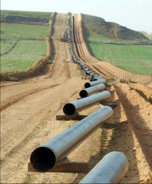
24 MPUC Docket No. PL-6668/PPL Section Page LAND REQUIREMENTS For the proposed pipeline, the applicant shall provide the following information: A. permanent right of way length, average width, and estimated acreage: The Sandpiper Pipeline Project preferred route, to the extent practicable, is co-located with EPND s existing right-of-way or other utility rights-of-way in Minnesota. In Minnesota, the preferred route follows the EPND System beginning at the North Dakota border south of Grand Forks, North Dakota in Polk County and extending east to Clearbrook, Minnesota. At Clearbrook, the preferred route then turns south and generally follows the existing Minnesota Pipe Line Company right-of-way to a point near Hubbard, Minnesota. From Hubbard, the preferred route turns east, following parts of existing third-party rights-of-way where practicable, to the Wisconsin border abutting Carlton County, Minnesota. The preferred route in Minnesota traverses approximately 299 miles. Right-of-Way Requirements West of Clearbrook From the North Dakota border to the Clearbrook Terminal, the Project will generally be constructed and installed adjacent to the existing EPND rightof-way. Typically, the right-of-way requirements in upland areas include up to 55-feet of permanent easement, of which 25-feet would be new easement and 65-feet of temporary workspace, for a total land requirement of 120-feet. In wetland areas, the temporary workspace requirement would be reduced to 40-feet, for a total land requirement of 95-feet. EPND s design configuration and anticipated construction execution methods are intended to take advantage of the proximity of the Project to the existing EPND pipeline west of Clearbrook to minimize new right-of-way requirements. Typical drawings depicting the construction footprint from the North Dakota border to Clearbrook in upland and wetland areas are included in Appendix F of the EIR. Right-of-Way Requirements East of Clearbrook From Clearbrook, Minnesota to the Wisconsin border, the preferred route will follow a portion of the Minnesota Pipe Line Company right-of-way and parts of existing electrical transmission and railroad lines. Where co-location is not practicable, the pipeline will, by necessity, be constructed in greenfield areas. For both co-located and greenfield areas, this typically results in a construction footprint of 120-feet for standard pipeline construction in upland
25 MPUC Docket No. PL-6668/PPL Section Page 2 areas, including 50-feet of permanent easement and 70-feet of temporary workspace. In wetland areas, the temporary workspace requirement would be reduced to 40-feet, for a total land requirement of 95-feet. Both the permanent easement and the temporary workspace areas may be returned to pre-existing uses by the landowners if they do not impact safe operation and inspection of the pipelines. Typical drawings depicting the construction footprint from Clearbrook to the Wisconsin border in upland and wetland areas, whether parallel to third-party rights-of-way or in greenfield locations are included in Appendix F of the EIR. In certain limited areas, the right-of-way encounters environmental features (such as extended wetlands) that require special construction methods. Typically, this results in a maximum construction footprint of 95-feet, including 50-feet of permanent easement and 45-feet of temporary workspace. EPND has presently identified approximately 9 miles of potential right-of-way in the following areas that contain environmental features that will necessitate these special construction methods: Milepost 395 to 396 Milepost 415 to 416 Milepost 460 to 462 Milepost 484 to 485 Milepost 496.5, 520, 546 and 555 Milepost 558 to 562 B. temporary right-of-way (workspace) length, estimated width, and estimated acreage: The Project will be constructed using a 120-foot-wide construction right-of-way consisting of existing or new easements. Approximately 65- to 70-feet of the 120-foot right-of-way will consist of temporary work space. Additional temporary workspace of up to 100-feet in width and 200-feet in length will be required at feature crossings (e.g., roads and waterbodies). For the 299-milelong portion of the preferred route that will cross Minnesota, construction will affect approximately 5,137 acres of land (see Table of the EIR). Access roads and pipeyards known as of the date of this filing are presented in Tables and of the EIR, respectively.
26 MPUC Docket No. PL-6668/PPL Section Page 3 C. estimated range of minimum trench or ditch dimensions including bottom width, top width, depth, and cubic yards of dirt excavated: Trenches will be dug using a trackhoe or crawler-mounted wheel type ditching machine. Typical trench dimensions are included in Table C. The total excavation will comprise approximately 1.35 million cubic yards of soil for the Project. Table C Typical Trench Dimensions 24-inch outside diameter pipe Minimum ditch depth to allow for a minimum of inches inches of ground cover to the top of the pipe 30-inch outside diameter pipe 66-inches Trench width at the bottom 3-feet 4-feet Trench width at the top 4-feet 5-feet D. minimum depth of cover for state and federal requirements: In accordance with federal requirements (49 Code of Federal Regulation ( C.F.R. ) Part ), the depth of cover between the top of the pipe and the ground level, road bed, or river bottom will range between 36- to 48- inches, depending on the location of the pipe and the presence of rock. State law requires that a minimum depth of cover of 54-inches be maintained in cultivated areas unless waived by the landowner. In locations where Sandpiper is co-located with adjacent pipelines that are buried in accordance with federal requirements, both safety and land use considerations have led EPND to propose the installation with a minimum 36- inch depth of cover. This approach will: minimize the amount of soil excavated and, therefore, reduce the total acreage temporarily impacted, and will decrease the loss of soil productivity through erosion; create no additional limits on deep plowing; facilitate crossings of pipelines at similar depths by other facilities; and alleviate the potential for existing lines to subside during installation of the new pipelines by installing new lines at close to the same elevation.
27 MPUC Docket No. PL-6668/PPL Section Page 4 To implement the proposed depth of installation, where necessary, landowners will be asked to waive the 54-inch minimum cover requirement, as was done during the 1994, 1998, 2002, and 2010 Enbridge expansion projects. E. right-of-way sharing or paralleling: type of facility in the right-of way, and the estimated length, width, and acreage of the right-of-way: West of Clearbrook, the Project will generally be constructed within and/or adjacent to existing EPND right-of-way and parallel to existing facilities described in Section Subpart 4.D. East of Clearbrook, the preferred route often parallels railroads, pipelines, highways, and other utilities and is crossed by such facilities.
28 MPUC Docket No. PL-6668/PPL Section Page PROJECT EXPANSION If the pipeline and associated facilities are designed for expansion in the future, the applicant shall provide a description of how the proposed pipeline and associated facilities may be expanded by looping, by additional compressor and pump stations, or by other available methods. As described in Sections and , the annual capacity of the Sandpiper Pipeline Project for the transportation of light crude oil is 225,000 bpd from the North Dakota border to Clearbrook, Minnesota and 375,000 bpd from Clearbrook, Minnesota to the Wisconsin border. In addition to the new pipeline, the Project involves adding a new terminal with two 150,000 bbl tanks and a new pump station near Clearbrook, Minnesota. EPND has designed the Project to facilitate capacity expansions in the future should shippers request the ability to move additional volumes in excess of the capacities requested in this application. The Project has been designed for an ultimate design capacity of 406,000 bpd (365,000 bpd annual capacity) from the North Dakota/Minnesota border to Clearbrook, Minnesota. From Clearbrook, Minnesota to the Minnesota/Wisconsin border the pipeline has been designed for an ultimate capacity of 711,000 bpd (640,000 bpd annual capacity). The increases in capacity to the ultimate design capacity would be achieved through the addition of new pumping units along the rightof-way. The pipeline will be designed, constructed, and hydrostatically tested for operation at the ultimate design capacity.
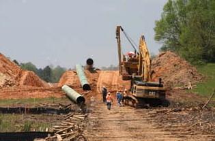
29 MPUC Docket No. PL-6668/PPL Section Page RIGHT-OF-WAY PREPARATION PROCEDURES AND CONSTRUCTION ACTIVITY SEQUENCE Each applicant shall provide a description of the general right-of-way preparation procedures and construction activity sequence anticipated for the proposed pipeline and related facilities. First, the right-of-way is surveyed, staked, and prepared for clearing. The right-of-way is then cleared and graded, as necessary, to provide construction access and safe movement of both equipment and personnel during construction. Silt fence and other erosion control measures are installed, and sensitive areas are marked for avoidance. Appropriate safety measures are implemented before excavation begins, including notification of the One-Call system to ensure third-party utilities and any adjacent pipelines are properly marked. Pipe, valves, and fittings are transported to the right-of-way by truck and placed along the right-of-way by side boom tractors or mobile cranes. After individual pipe sections are strung along the right-of-way, they are bent to conform to the contours of the trench and terrain. The pipe segments are lined up, clamped, welded, field coated, and inspected. Trenching may occur before or after the pipe has been welded. Trenching is typically conducted using a backhoe or a crawler-mounted, wheel-type trenching machine. Where appropriate, topsoil is segregated according to applicable permit conditions. Prepared pipe is lowered into the trench and, where applicable, tied into existing facilities. During backfilling, subsoil is replaced first and then the topsoil is replaced. Precautions, such as padding the trench with soil, are taken during backfilling to protect the pipe from rock damage. Once the pipeline has been welded and inspected, and the trench has been backfilled, the pipeline is hydrostatically tested to ensure its integrity prior to the line being filled with crude oil and placed into service. The right-of-way is then cleaned up and restored to preconstruction conditions, as practicable. Restoration includes implementing temporary and permanent stabilization measures such as slope breakers, mulching and seeding. Section 1.3 of the EIR provides a detailed description of construction activities along with a diagram depicting the typical construction sequence.
30 MPUC Docket No. PL-6668/PPL Section Page PREFERRED ROUTE LOCATION; ENVIRONMENT DESCRIPTION Subpart 1. Preferred route location. The applicant must identify the preferred route for the proposed pipeline and associated facilities, on any of the following documents which must be submitted with the application: A. United States Geological Survey topographical maps to the scale of 1:24,000, if available; B. Minnesota Department of Transportation county highway maps; or C. aerial photos or other appropriate maps of equal or greater detail in items A and B. The maps or photos may be reduced for inclusion in the application. One full-sized set shall be provided to the commission. U.S. Geological Survey ( USGS ) topographical maps and aerial photo maps for the preferred pipeline route from the North Dakota state line in Polk County, Minnesota to the Wisconsin state line in Carlton County, Minnesota are included in Appendix G.5 of the EIR. Subpart 2. Other route locations. All other route alternatives considered by the applicant must be identified on a separate map or aerial photos or set of maps and photos or identified in correspondence or other documents evidencing consideration of the route by the applicant. EPND studied a variety of routes for the preferred pipeline. The study consisted of the no-action alternative, system alternatives, and route alternatives. To be considered viable, an alternative had to meet three factors: ability to meet project objectives; technical and economic feasibility; and have significant land use compatibility and environmental advantage over the preferred route. Section 2.0 of the EIR provides a detailed analysis of the alternatives considered and Section of this application provides a summary of this analysis.
31 MPUC Docket No. PL-6668/PPL Section Page 2 Subpart 3. Description of environment. The applicant must provide a description of the existing environment along the preferred route. EPND prepared an Environmental Information Report for the Project that provides a description of the existing environment and socioeconomic conditions along the preferred route, an analysis of potential human and environmental impacts, and a discussion of measures that will be taken to minimize or mitigate adverse impacts and protect and restore the right-of-way. A summary of the existing environmental conditions along the preferred route is provided below. A summary of potential environmental impacts and mitigation measures is provided in Section of this application. Socioeconomics County population levels within the project area range from 4,087 persons in Red Lake County to 62,882 persons in Crow Wing County. In general, population levels are low in these counties. Population densities (an indicator of the extent of development) in the counties affected by the project averages 22.9 people per square mile. All county-level population densities along the preferred route are lower than the Minnesota average of 66.6 people per square mile, reflecting the generally rural character of much of the preferred route. The April 2013 unemployment rates in the project area varied from 5.3 percent in Polk County to 15.2 percent in Clearwater County (compared to a statewide average of 5.4 percent). Employment in the project area is concentrated in the following sectors: education, health, and social services, retail trade, manufacturing, arts, entertainment, recreation, accommodation and food services, and construction industries. Education, health and social services, retail trade and manufacturing are the top employment industries in the counties crossed by the preferred route. Per capita income in 2011 ranged from $22,408 in Red Lake County to $25,645 in Crow Wing County. In general, per capita income is lowest in rural counties with low population densities and high unemployment rates, and highest in urban counties with high population densities and low unemployment rates. Five municipalities are located within approximately one mile of the preferred route and no municipal boundaries would be crossed by the preferred route (see Table of the EIR). Section 3.0 of the EIR provides additional details regarding socioeconomic conditions. Land Use Using the USGS Land Use and Land Cover Classification System, EPND identified land use along the preferred route (including the construction rightof-way and known additional temporary workspaces) and classified it into the following five categories based on prevalent land use and vegetation cover
32 MPUC Docket No. PL-6668/PPL Section Page 3 types: agricultural lands, developed lands, forest lands, open lands, and wetlands/open water. The predominant land use identified along the preferred route is forested land, which accounts for 1,946 acres (or 38 percent) of the total construction area. Agricultural land accounts for 1,761 acres (or 34 percent) of the total construction area. Of the agricultural land affected, approximately 60 percent is cultivated and the remaining 40 percent is pasture land. Other land uses are wetland/open water (824 acres or 16 percent), open land (590 acres or 12 percent), and developed land (15 acres or less than 1 percent) (see section 4.2 of the EIR). The land use categories that will be affected resulting from the siting of the new Clearbrook terminal facilities include agricultural land (78 acres or 85 percent), wetland (7 acres or 7 percent), forested land (4 acres or 4 percent), and open land (3 acres or 3 percent). The land use categories that will be affected resulting from the siting of the Pine River facility will be forest land (10 acres or 98 percent of the site) and open space (less than 1 acre or 2 percent of the site). The preferred route predominantly crosses private land (229 miles or approximately 77 percent of the route). The p r e f e r r e d route also crosses state lands (26 miles or approximately 9 percent of the route) and county lands (44 miles or approximately 15 percent of the route) (see section of the EIR). Section 4.0 of the EIR provides details regarding land use. Terrain and Geology The Project primarily traverses the Interior Plain Physiographic Province, crossing into the Laurentian Upland Province Superior Upland in the eastern portion of its route in Minnesota. The geologic terrain of both of these provinces is characterized by ancient pre-cambrian igneous and metamorphic rocks that have been uplifted and eroded to a relatively lowrelief plain, forming the stable geologic core of the North American continent, known as the craton. The North American craton, which is crossed by the Project, has been tectonically stable for over 500 million years. Therefore, there is a low probability of an earthquake of significant intensity or other seismic event in the Project area. Maps of regional coverage of depth-to-bedrock generally are not of sufficient resolution to identify areas where bedrock occurs at specific depths; therefore, information on depth to bedrock in a specific location is difficult to determine without sampling. Generally, the depth to bedrock along the preferred route can exceed more than 450-feet. Less than 1 percent of the route (from approximate milepost ( MP ) to MP in Carlton County) crosses an area of more or less continuous bedrock exposure (see section 5.1 of the EIR). Blasting may be required if bedrock is encountered
33 MPUC Docket No. PL-6668/PPL Section Page 4 within the depth of the trench. Nineteen sand and gravel quarry operations are present within 1,500-feet of the construction workspace. Four areas of active metallic mineral leases on state lands are present within 1,500-feet of the construction workspace, and three active leases will be crossed by pipeline construction in Aitkin and Carlton counties (see section of the EIR). Section 5.0 of the EIR provides details regarding geological resources. Soils The preferred route will cross the following Major Land Resource Areas: Red River Valley of the North; Northern Minnesota Gray Drift; Rolling Till Prairie; Northern Minnesota Glacial Lake Basins; Superior Lake Plain; Central Minnesota Sandy Outwash; and Wisconsin and Minnesota Thin Loess and Till, Northern part. Soils in these areas range from somewhat poorly drained soils with loamy and clayey textures to sandy soils that are well or excessively drained. Soils have a frigid temperature regime, an aquic or udic soil moisture regime, and mixed, smectitic, or isotic mineralogy. Approximately 59 percent of the soils within the Project area are considered prime farmland, 37 percent are hydric, 23 percent are compaction-prone, 15 percent are susceptible to water erosion, 71 percent are susceptible to wind erosion, 39 percent pose re-vegetative concern, and less than 1 percent of the route crosses shallow bedrock (see section of the EIR). Section 6.0 of the EIR provides details regarding soil resources. Vegetation, Wildlife, and Fisheries Sandpiper will be constructed through multiple biomes, including deciduous forest, conifer forest, and prairie. Wildlife habitats within these areas are diverse and include open areas, wetlands, and forested areas. Within agricultural areas, wildlife habitat is limited and confined primarily to the undeveloped areas. Common mammalian species, including white-tailed deer, woodchucks, striped skunks, raccoons, weasels, Virginia opossum, and various mice and voles, use these areas for feeding and cover. Common bird species, such as European starlings, American crows, eastern meadowlarks, and house sparrows, are also typically found in agricultural areas. Forested areas affected by the project are found primarily along the eastern portion of the preferred route. Mammalian species include eastern chipmunks, black bears, snowshoe hares, gray squirrels, gray fox, porcupines, pine martens, and several species of bats. Wetlands affected by the project consist primarily of emergent herbaceous
34 MPUC Docket No. PL-6668/PPL Section Page 5 wetlands, woody wetlands, and open water. The emergent wetlands and open water provide habitat for a variety of aquatic wildlife, including muskrats, beavers, mink, river otters, waterfowl, wading birds, and numerous species of reptiles and amphibians. The woody wetlands provide additional habitat for terrestrial wildlife, such as white-tailed deer, moose, gray wolves, black bears, and a variety of small mammals and songbirds. Open land affected by the project consists primarily of shrub/scrub areas, grasslands, developed open space, and barren land. The undeveloped, vegetated open lands likely support several species of birds, numerous small rodents, and several species of snakes. Species such as coyote, red fox, and a variety of raptors typically hunt open areas for the varied prey. Other common wildlife species that may use open areas include thirteen-lined ground squirrels, eastern cottontail rabbits, and white-tailed jackrabbits. The preferred route crosses 73 perennial and 76 intermittent streams in Minnesota (see table of the EIR). A list of waterbodies crossed by the Project is included in Appendix E of the EIR. Most of these waterbodies contain warm water fisheries. The preferred route also will cross 13 Minnesota Department of Natural Resources ( MNDNR )-designated trout streams (see section of the EIR). Game fish that may occur in stream crossings in the project area include bass, bullhead, catfish, crappie, muskellunge, perch, pike, sunfish, walleye, and trout. The preferred route crosses four Wildlife Management Areas ( WMAs ) and two Aquatic Management Areas ( AMAs ) (see section of the EIR). EPND initiated consultation with the U.S. Fish and Wildlife Service ( USFWS ) to understand the potential presence of threatened and endangered species in the vicinity of the Project and establish approved survey protocols. EPND discussed the USFWS initial recommendations with USFWS staff over the phone and received an with information on federally listed species in Minnesota. At the request of USFWS and pursuant to the federal process, further consultations will not proceed until a lead federal agency has been identified and the subsequent designation of EPND as the non-federal representative for the federal agency under the Endangered Species Act occurs. EPND also initiated consultation with the MNDNR Endangered Species Review Coordinator to understand the potential presence of threatened and endangered species in the vicinity of the Project. EPND conducted a review of the Minnesota Natural Heritage Information in cooperation with the MNDNR to determine if any federally or state-listed species are known to occur within a 2-mile-wide study area centered on the preferred route. Results of the review are presented in Table of the EIR.
35 MPUC Docket No. PL-6668/PPL Section Page 6 Section 7.0 of the EIR provides detailed information about vegetation, wildlife, fisheries, and threatened and endangered species. Water Resources Groundwater Groundwater along the preferred route occurs in surficial aquifers and buried drift aquifers. Surficial aquifers occur above bedrock in unconsolidated sediments deposited by glaciers, streams, and lakes. Buried drift aquifers occur in well sorted sands and gravels deposited in bedrock valleys, alluvial channels, and outwash plains. Of the two types, surficial aquifers are most susceptible to impacts from construction because of the relatively shallow depth of the water table and coarse texture of the material overlying the aquifer. EPND identified 12 domestic water supply wells within 200- feet of the preferred route; one well was for a test hole and another was for an irrigation well. No public water supply wells were identified in the vicinity of the Project (see section of the EIR). Current Minnesota Department of Health ( MDH ) regulations require a well isolation distance of 100-feet for petroleum pipelines (Minnesota Rules, Chapter 4725). The preferred route will not cross any aquifers that are designated by the US Environmental Protection Agency ( EPA ) as sole-source aquifers. The Project will cross about 0.2 miles of a Drinking Water Supply Management Area ( DWSMA ) in the vicinity of Park Rapids (see section of EIR). The MDH rates the sensitivity of the aquifer that supplies the well for that water supply as high. EPND has initiated consultation with the operators of the DWSMA and the MDH regarding this crossing. EPND accessed a Minnesota Pollution Control Agency ( MPCA ) database to identify sites with known or potential contamination within 0.5 mile of the preferred route. EPND identified 16 sites, and all were determined to be more than 500-feet from the preferred pipeline route and are not anticipated to be impacted by or impact the Project (see section 8.3 of the EIR). Following final route selection and prior to construction, EPND will re-assess the potential for encountering contaminated groundwater near sites that are within 500-feet of the final pipeline route. If necessary, appropriate avoidance or mitigation measures will be developed and implemented at that time in accordance with applicable state or federal regulations. Section 8.0 of the EIR provides details regarding groundwater resources. Water Resources Surface Water Surface waters crossed by the preferred route are located within the Red River of the North, Mississippi Headwaters, St. Croix River, and Western Lake Superior Basins. The Project will cross the Red Lake and Wild Rice Watershed Districts. The primary purpose of these watershed districts is to conserve the natural resources of the state through land use planning, flood
Before the Minnesota Public Utilities Commission Docket No. PL-6668/PPL November 2013 Sandpiper Pipeline Project
 Before the Minnesota Public Utilities Commission Docket No. PL-6668/PPL-13-474 November 2013 Sandpiper Pipeline Project BEFORE THE MINNESOTA PUBLIC UTILITIES COMMISSION Beverly Jones Heydinger Chair Dr.
North Dakota Pipeline Company
 North Dakota Pipeline Company Before the Minnesota Public Utilities Commission Docket No. PL-6668/PPL-13-474 REVISED JANUARY 31, 2014 Sandpiper Pipeline Project Pipeline Routing Permit Application MPUC
HISTORICAL ENERGY DATA
 MPUC Docket No.PL-6668/CN-13-473 Section 7853.0510 Page 1 The section contains trade secret and privileged information that has been excised from the Certificate of Need Application available to the public.
Before the Minnesota Public Utilities Commission Docket No. PL-6668/CN November 2013 Sandpiper Pipeline Project
 Before the Minnesota Public Utilities Commission Docket No. PL-6668/CN-13-473 November 2013 Sandpiper Pipeline Project BEFORE THE MINNESOTA PUBLIC UTILITIES COMMISSION Beverly Jones Heydinger Chair Dr.
/s/ Michael T. Loeffler. Michael T. Loeffler Senior Director, Certificates and External Affairs. Attachment. May 24, 2018.
 Northern Natural Gas Company P.O. Box 3330 Omaha, NE 68103-0330 402 398-7200 May 24, 2018 Via efiling Ms. Kimberly D. Bose, Secretary Federal Energy Regulatory Commission 888 First Street, N.E. Washington,
North Dakota Pipeline Company LLC Before the Minnesota Public Utilities Commission Docket No. PL-6668/CN REVISED JANUARY 31, 2014
 Before the Minnesota Public Utilities Commission Docket No. PL-6668/CN-13-473 REVISED JANUARY 31, 2014 Sandpiper Pipeline Project Certificate of Need Application MPUC Docket No. PL-6668/CN-13-473 REVISED
/s/ Michael T. Loeffler. Michael T. Loeffler Senior Director, Certificates and External Affairs. Attachment. October 11, 2018.
 Northern Natural Gas Company P.O. Box 3330 Omaha, NE 68103-0330 402 398-7200 October 11, 2018 Via efiling Ms. Kimberly D. Bose, Secretary Federal Energy Regulatory Commission 888 First Street, N.E. Washington,
/s/ Michael T. Loeffler. Michael T. Loeffler Senior Director, Certificates and External Affairs. Attachment. October 12, 2018.
 Northern Natural Gas Company P.O. Box 3330 Omaha, NE 68103-0330 402 398-7200 October 12, 2018 Via efiling Ms. Kimberly D. Bose, Secretary Federal Energy Regulatory Commission 888 First Street, N.E. Washington,
/s/ Michael T. Loeffler. Michael T. Loeffler Senior Director, Certificates and External Affairs. Attachment. July 9, 2018.
 Northern Natural Gas Company P.O. Box 3330 Omaha, NE 68103-0330 402 398-7200 July 9, 2018 Via efiling Ms. Kimberly D. Bose, Secretary Federal Energy Regulatory Commission 888 First Street, N.E. Washington,
Environmental Information Worksheet
 Environmental Information Worksheet Water System Owner (Attach additional sheets if necessary) Needs and Alternatives Provide a brief narrative that describes: Current drinking water system needs. Project
/s/ Michael T. Loeffler. Michael T. Loeffler Senior Director, Certificates and External Affairs. Attachment. November 15, 2018.
 Northern Natural Gas Company P.O. Box 3330 Omaha, NE 68103-0330 402 398-7200 November 15, 2018 Via efiling Ms. Kimberly D. Bose, Secretary Federal Energy Regulatory Commission 888 First Street, N.E. Washington,
ADELPHIA GATEWAY PROJECT
 ADELPHIA GATEWAY PROJECT RESOURCE REPORT NO. 10 Alternatives ADELPHIA GATEWAY PROJECT January 2018 SUMMARY OF FILING INFORMATION INFORMATION Data Sources a Found in Section To be Filed Minimum Requirements
Response: Eastern Shore will require additional permanent easement and temporary workspace (TWS) in the following municipalities:
 in the following municipalities:") 2. There are multiple properties throughout the Chester County portion of the 2017 Expansion Project area which contain preservation easements on them. Eastern Shore Natural Gas Company should be aware
2. There are multiple properties throughout the Chester County portion of the 2017 Expansion Project area which contain preservation easements on them. Eastern Shore Natural Gas Company should be aware
Keystone Projects Overview
 Keystone Projects Overview TransCanada Assets Wholly Owned Natural Gas Pipeline Partially Owned Natural Gas Pipeline Natural Gas Pipeline Under Construction Natural Gas Pipeline In Development Natural
ARTICLE 6 EXCAVATION OF MINERAL MATERIALS
 ARTICLE 6 EXCAVATION OF MINERAL MATERIALS SECTION 1. PURPOSE All excavations, extraction of materials and minerals, open pits and impounding of waters hereafter established or enlarged shall conform to
Information for File # KAL
 Information for File # 2016-03711-KAL Applicant Corps Contact Enbridge Energy, Limited Partnership Kristoffer A. Laman Address 600 South Lake Avenue, Suite 211, Duluth, MN 55802 E-Mail Kristoffer.A.Laman@usace.army.mil
Kobe Pumping Plant and Pipeline Project Narrative UPDATED 6/28/13
 Kobe Pumping Plant and Pipeline Project Narrative UPDATED 6/28/13 Introduction/Background The Kobe Pumping Plant and Pipeline (the Project ) is located in Mesa and Garfield Counties near DeBeque, Colorado.
PUBLIC NOTICE Application for Permit
 PUBLIC NOTICE Application for Permit Issue Date: March 4, 2016 Expiration Date: April 4, 2016 US Army Corps of Engineers No: NWP-2015-432 30-Day Notice Oregon Department of State Lands No: 58511 Interested
DEPARTMENT OF THE ARMY JACKSONVILLE DISTRICT CORPS OF ENGINEERS POST OFFICE BOX 4970 JACKSONVILLE, FLORIDA May 9, 2016
 DEPARTMENT OF THE ARMY JACKSONVILLE DISTRICT CORPS OF ENGINEERS POST OFFICE BOX 4970 JACKSONVILLE, FLORIDA 32232 REPLY TO ATTENTION OF May 9, 2016 Regulatory Division North Permits Branch Jacksonville
PRESS KIT MEDIA CONTACT. Chris Stockton Office Number: Cell Number:
 PRESS KIT MEDIA CONTACT Chris Stockton Email: Christopher.L.Stockton@williams.com Office Number: 713-215-2010 Cell Number: 713-562-2939 ABOUT WILLIAMS Williams is a nearly 110-year-old energy company that
FEDERAL ENERGY REGULATORY COMMISSION FIELD INSPECTION REPORT
 FIELD INSPECTION REPORT Date July 10 and 11, 2018 Project WBI Energy Transmission, Inc. Valley Expansion Project Clay County, Minnesota; and Cass County, North Dakota Authority: Section 7(c) Personnel
Public Notice U.S. ARMY CORPS OF ENGINEERS, GALVESTON DISTRICT
 Public Notice U.S. Army Corps Permit Application No: SWG-2015-00114 Of Engineers Date Issued: 18 October 2018 Galveston District Comments Due: 19 November 2018 U.S. ARMY CORPS OF ENGINEERS, GALVESTON DISTRICT
GRADING, EROSION AND SEDIMENTATION CONTROL
 SECTION 500 GRADING, EROSION AND SEDIMENTATION CONTROL 501 Erosion and Sedimentation Control Plan All engineering plans for projects that propose to construct new, or modify existing drainage facilities,
GUIDE TO THE DEVELOPMENT OF A MINING AND RECLAMATION PLAN IN NEW BRUNSWICK
 PROVINCE OF NEW BRUNSWICK DEPARTMENT OF ENERGY AND RESOURCE DEVELOPMENT Minerals and Petroleum Development Branch GUIDE TO THE DEVELOPMENT OF A MINING AND RECLAMATION PLAN IN NEW BRUNSWICK Guide to the
October 25, Via efiling. Ms. Kimberly D. Bose, Secretary Federal Energy Regulatory Commission 888 First Street, N.E. Washington, D.C.
 Northern Natural Gas Company P.O. Box 3330 Omaha, NE 68103-0330 402 398-7200 October 25, 2018 Via efiling Ms. Kimberly D. Bose, Secretary Federal Energy Regulatory Commission 888 First Street, N.E. Washington,
Maine s Land Use Regulations and Erosion Control Techniques
 Maine s Land Use Regulations and Erosion Control Techniques Protecting Maine s Air, Land and Water Colin Clark 441-7419 colin.a.clark@maine.gov Tom Gilbert 441-8031 thomas.gilbert@maine.gov Jim Rodrigue
People Are Asking Us About Our Rover Pipeline Project
 People Are Asking Us About Our Rover Pipeline Project As we begin work on our Rover Pipeline Project, we know you may have a number of questions about our project and how the plans could potentially affect
FERC PDF (Unofficial) 10/08/2014. Environmental Impact Statement ES-1 Corpus Christi LNG
 10/08/2014. Environmental Impact Statement ES-1 Corpus Christi LNG") EXECUTIVE SUMMARY The staff of the Federal Energy Regulatory Commission (FERC or Commission) prepared this Environmental Impact Statement (EIS) to assess the environmental issues associated with the construction
EXECUTIVE SUMMARY The staff of the Federal Energy Regulatory Commission (FERC or Commission) prepared this Environmental Impact Statement (EIS) to assess the environmental issues associated with the construction
STATE OF MINNESOTA ENVIRONMENTAL QUALITY BOARD
 STATE OF MINNESOTA ENVIRONMENTAL QUALITY BOARD In the Matter of the Application of Enbridge Energy Partners, Limited Partnership for a Pipeline Routing Permit and for a Partial Exemption from Pipeline
APPENDIX H: SFEIS FLOODPLAIN IMPACT ANALYSIS SECTION
 TH 36/STH 64 St. Croix River Crossing 2005 Water Resources Preliminary Design Report APPENDIX H: SFEIS FLOODPLAIN IMPACT ANALYSIS SECTION within the project area. Other methods of attaining this reduction
FEDERAL ENERGY REGULATORY COMMISSION FIELD INSPECTION REPORT
 FIELD INSPECTION REPORT Date May 22, 2018 Project Northern Natural Gas Company Cedar Station Upgrade Project Dakota County, Minnesota Authority: Sections 7(c) Personnel FERC Staff: Company Staff: S. Xiah
Tennessee Gas Pipeline Company L.L.C Louisiana Street Suite 1000 Houston, Texas
 THIS IS NOT A PAID ADVERTISEMENT 0BPublic Notice Wanamaker Building 100 Penn Square East Philadelphia, PA 19107-3390 ATTN: CENAP-OP-R Public Notice No. 1BCENAP-OP-R-2015-0802-65 Application No. In Reply
Roadrunner Gas Transmission Pipeline. Project Overview
 Roadrunner Gas Transmission Pipeline Project Overview New Pipeline Being Constructed in Your Area Overview Tulsa-based ONEOK Partners has entered into a 50-50 joint venture with a subsidiary of Fermaca
VALLEY LATERAL PROJECT. RESOURCE REPORT 11 Reliability and Safety. FERC Docket No. CP
 VALLEY LATERAL PROJECT RESOURCE REPORT 11 Reliability and Safety FERC Docket No. CP16- -000 November 2015 Section TABLE OF CONTENTS Page 11.0 RELIABILITY AND SAFETY... 11-1 11.1 NATURAL GAS PIPELINE INDUSTRY
Attachment C Applicant s Proposed Mitigation Statement Alaska DOT&PF Northern Region Pilot Station Airport Relocation Project POA
 Attachment C Applicant s Proposed Mitigation Statement Alaska DOT&PF Northern Region Pilot Station Airport Relocation Project POA-2004-1223 Introduction This mitigation statement was prepared as an attachment
January 2, Federal Energy Regulatory Commission 888 First Street, N.E. Washington, D.C Attention: Ms. Kimberly D.
 January 2, 2019 Federal Energy Regulatory Commission 888 First Street, N.E. Washington, D.C. 20426 Attention: Ms. Kimberly D. Bose, Secretary Re: El Paso Natural Gas Company, L.L.C.; Docket No. CP18-332-000;
Minnesota EAW Supplement
 Appendix I: Minnesota EAW Supplement Lower Pool 2 Channel Management Study: Boulanger Bend to Lock and Dam No. 2 Minnesota EAW Item Identification A supplement prepared for the Minnesota DNR to identify
Williams Transco Pipeline
 open house Williams Transco Pipeline Williams Transco pipeline is a major transporter of natural gas, delivering much of the natural gas consumed in the northeastern and southeastern United States. Transco
STANDARD GRADING AND SOIL EROSION & SEDIMENT CONTROL PLAN FOR SINGLE LOT SINGLE FAMILY RESIDENTIAL CONSTRUCTION AND MINOR EARTH DISTURBANCES
 DIVISION OF ENGINEERING & CONSTRUCTION MANAGEMENT PLAN REVIEW DEPARTMENT WASHINGTON COUNTY SOIL CONSERVATION DISTRICT 1260 Maryland Avenue, Suite 101 Hagerstown, MD 21740 Telephone: (301) 797-6821, Ext.
Technical Data
 4906-17-05 Technical Data (A) PROJECT AREA SITE have occurred in this section. (1) Geography and Topography have occurred in this section. (2) Aerial Photography have occurred in this section. (3) Site
BEFORE THE MINNESOTA PUBLIC UTILITIES COMMISSION. Beverly Jones Heydinger
 BEFORE THE MINNESOTA PUBLIC UTILITIES COMMISSION Beverly Jones Heydinger David C. Boyd Nancy Lange Dan Lipschultz Betsy Wergin In the Matter of the Applications of North Dakota Pipeline Company LLC for
Barr Engineering Company 4700 West 77th Street Minneapolis, MN Phone: Fax: An EEO Employer
 Barr Engineering Company 4700 West 77th Street Minneapolis, MN 55435-4803 Phone: 952-832-2600 Fax: 952-832-2601 www.barr.com An EEO Employer Minneapolis, MN Hibbing, MN Duluth, MN Ann Arbor, MI Jefferson
Reclamation Plan for the Non-metallic Mining Site owned and operated by Birds Eye Foods, LLC.
 MEMO Date: April 15, 2011 Land Use and Resource Management To: From: Walworth County Zoning Agency Matthew Weidensee, Associate Planner, Land Use Division Fay Amerson, Urban Program Specialist, Walworth
Roanoke County Board of Supervisors. October 14, 2014
 Roanoke County Board of Supervisors October 14, 2014 Who is Mountain Valley Pipeline, LLC Joint venture of EQT Corporation and NextEra Energy EQT: Leading Appalachian natural gas production and transmission
FEDERAL ENERGY REGULATORY COMMISSION FIELD INSPECTION REPORT
 FIELD INSPECTION REPORT Date June 19, 2018 Project Northern Natural Gas Company (Northern) Cedar Station Upgrade Project Dakota County, Minnesota Authority: Section 7(c) Personnel FERC Staff: Company Staff:
MINNEHAHA CREEK WATERSHED DISTRICT BOARD OF MANAGERS REVISIONS PURSUANT TO MINNESOTA STATUTES 103D.341. Adopted April 24, 2014 Effective June 6, 2014
 MINNEHAHA CREEK WATERSHED DISTRICT BOARD OF MANAGERS REVISIONS PURSUANT TO MINNESOTA STATUTES 103D.341 Adopted April 24, 2014 Effective June 6, 2014 EROSION CONTROL RULE 1. POLICY. It is the policy of
Lignite Mining and Reclamation Process. Kayla Torgerson The Coteau Properties Co.
 Lignite Mining and Reclamation Process Kayla Torgerson The Coteau Properties Co. 1 Presentation Overview History of Regulation The Process of Mining and Reclamation Harmony Lake 2 1 2 3 4 5 6 7 8 Which
NOTICE OF A PROPOSED CHANGE TO AN APPROVED DEVELOPMENT
 NOTICE OF A PROPOSED CHANGE TO AN APPROVED DEVELOPMENT LEGACY PROJECT K+S Potash Canada GP November 30, 2012 TABLE OF CONTENTS 1. Introduction... 3 2. Description of Proposed Change... 4 3. Existing Environment...11
Environmental Resource Inventories. What are ERIs? Significance of information How to use them
 Environmental Resource Inventories What are ERIs? Significance of information How to use them Environmental Resource Inventory - ERI Compiled by the environmental commission Information about the natural
ATTACHMENT A: FINDINGS
 ATTACHMENT A: FINDINGS 1.0 CEQA FINDINGS 1.1 CEQA Exemption The County Planning Commission finds that the proposed project is exempt from environmental review under the California Environmental Quality
Storm Water Pollution Prevention Plan for CES Gravel #3800
 David Lewis Cell: (870) 310-2757 Rickey Vaughn Cell: (870) 310-9602 Buddy McAdams Cell: (870) 310-8733 Local (870) 881-8830 Fax: (870) 881-8809 LICENSED, BONDED & INSURED Howard Cupp, Jr. Cell: (870) 314-2877
Sandpiper Pipeline: Comparison of Environmental Effects of Reasonable Alternatives
 Sandpiper Pipeline: Comparison of Environmental Effects of Reasonable Alternatives In the Matter of the Application of North Dakota Pipeline Company LLC for a Certificate of Need for the Sandpiper Pipeline
Public Notice ISSUED: 13 May 2014 EXPIRES: 12 June 2014
 APPLICANT: Hawkes Company, Inc REFER TO: 1999-04864-CLJ Public Notice ISSUED: 13 May 2014 EXPIRES: 12 June 2014 SECTION: 404 - Clean Water Act 1. APPLICATION FOR PERMIT TO retain dredged and fill material
SECTION 10: WETLANDS PROTECTION
 SECTION 10: WETLANDS PROTECTION 10-1 INTENT AND PURPOSE A. Intent 1. The City finds that wetlands serve a variety of beneficial functions. Wetlands maintain water quality, reduce flooding and erosion,
VALLEY LATERAL PROJECT. RESOURCE REPORT 1 General Project Description. FERC Docket No. CP
 VALLEY LATERAL PROJECT RESOURCE REPORT 1 General Project Description FERC Docket No. CP16- -000 November 2015 Section TABLE OF CONTENTS Page 1.0 RESOURCE REPORT 1 GENERAL PROJECT DESCRIPTION... 1-1 1.1
City of Valdosta Land Development Regulations
 Chapter 324 Section 324-1 Environmental Planning Criteria Protection of Groundwater Recharge Areas (A) Purpose and Intent. Pursuant to O.C.G.A. 12-2-8 and the Georgia Department of Natural Resources (DNR),
SemCAMS Area Project Description
 REGULATORY The Redwillow Pipeline Project involves crossing a provincial boundary, and therefore, approval for it will require the preparation of an application to the NEB. plans to proceed with the regulatory
STATE OF MINNESOTA MINNESOTA POLLUTION CONTROL AGENCY
 STATE OF MINNESOTA MINNESOTA POLLUTION CONTROL AGENCY In the Matter of the Decision on the Need for an Environmental Impact Statement for the Proposed Remer Wastewater Treatment Facility Expansion FINDINGS
May 24, Via efiling. Ms. Kimberly D. Bose, Secretary Federal Energy Regulatory Commission 888 First Street, N.E. Washington, D.C.
 Northern Natural Gas Company P.O. Box 3330 Omaha, NE 68103-0330 402 398-7200 May 24, 2018 Via efiling Ms. Kimberly D. Bose, Secretary Federal Energy Regulatory Commission 888 First Street, N.E. Washington,
SECTION 12 STANDARDS FOR CONSTRUCTION PLANS AND SPECIFICATIONS
 SECTION 12 STANDARDS FOR CONSTRUCTION PLANS AND SPECIFICATIONS 12.1 The subdivider shall construct and install the improvements in accordance with the County's Standards for Construction Plans and Specifications
SPECIAL PROVISIONS WATERWAY PERMITS CONDITIONS PID: Date: 3/8/18 C-R-S: UNI-TR
 SPECIAL PROVISIONS WATERWAY PERMITS CONDITIONS C-R-S: UNI-TR 0308-00.57 PID: 99910 Date: 3/8/18 Special Provisions: UNI-TR 0308-00.57, PID 99910 Page 2 of 7 1. Waterway Permits Time Restrictions: USACE
U.S. Army Corps of Engineers (USACE) Galveston District
 Galveston District") Appendix II U.S. Army Corps of Engineers (USACE) Galveston District SWG MITIGATION BANK PROSPECTUS TEMPLATE This Template includes the information required for a mitigation bank prospectus as outlined
Appendix II U.S. Army Corps of Engineers (USACE) Galveston District SWG MITIGATION BANK PROSPECTUS TEMPLATE This Template includes the information required for a mitigation bank prospectus as outlined
/s/ Michael T. Loeffler. Michael T. Loeffler Senior Director, Certificates and External Affairs. Attachment. July 18, 2017.
 Northern Natural Gas Company P.O. Box 3330 Omaha, NE 68103-0330 402 398-7200 July 18, 2017 Via efiling Ms. Kimberly D. Bose, Secretary Federal Energy Regulatory Commission 888 First Street, N.E. Washington,
CLEARWATER TOWNSHIP WATER QUALITY ACTION PLAN
 CLEARWATER TOWNSHIP WATER QUALITY ACTION PLAN Elk-River-Chain-of-Lakes Gaps Analysis Project The Watershed Center Grand Traverse Bay Michigan Department of Environmental Quality July 2011 Purpose The Grand
/s/ Michael T. Loeffler. Michael T. Loeffler Senior Director, Certificates and External Affairs. Attachment. May 31, 2017.
 Northern Natural Gas Company P.O. Box 3330 Omaha, NE 68103-0330 402 398-7200 May 31, 2017 Via efiling Ms. Kimberly D. Bose, Secretary Federal Energy Regulatory Commission 888 First Street, N.E. Washington,
NEW CASTLE CONSERVATION DISTRICT. through. (Name of Municipality) PLAN REVIEW APPLICATION DRAINAGE, STORMWATER MANAGEMENT, EROSION & SEDIMENT CONTROL
 PLAN REVIEW APPLICATION DRAINAGE, STORMWATER MANAGEMENT, EROSION & SEDIMENT CONTROL") NEW CASTLE CONSERVATION DISTRICT through (Name of Municipality) PLAN REVIEW APPLICATION DRAINAGE, STORMWATER MANAGEMENT, EROSION & SEDIMENT CONTROL Office use only: Received by Municipality: Received by
NEW CASTLE CONSERVATION DISTRICT through (Name of Municipality) PLAN REVIEW APPLICATION DRAINAGE, STORMWATER MANAGEMENT, EROSION & SEDIMENT CONTROL Office use only: Received by Municipality: Received by
1.0 INTRODUCTION 1.1 PROJECT OVERVIEW 1.2 PROJECT OBJECTIVES
 1.0 INTRODUCTION 1.1 PROJECT OVERVIEW The proposed ERG Foxen Petroleum Pipeline (Project) would be located in northern Santa Barbara County, six miles east of the City of Santa Maria, and between the towns
Groundwater Management Challenges. Jason Moeckel Minnesota DNR Division of Ecological and Water Resources
 Groundwater Management Challenges Jason Moeckel Minnesota DNR Division of Ecological and Water Resources DNR Strategies 1. Heighten the priority given to groundwater 2. Enhance the information available
PUBLIC NOTICE U.S. ARMY CORPS OF ENGINEERS
 ISSUE DATE: December 15, 2015 EXPIRATION DATE: January 15, 2016 PUBLIC NOTICE U.S. ARMY CORPS OF ENGINEERS Availability of Draft Environmental Assessment and Draft Finding of No Significant Impact REPLY
Background. Literature Review
 Ms. Joanna Helms Economic Development Director Town of Apex 73 Hunter Street P.O. Box 250 Apex, North Carolina 27502 October 23, 2015 Reference: Report of Wetland Determination Cash Perkins Site ECS Project
June 6, Via efiling. Ms. Kimberly D. Bose, Secretary Federal Energy Regulatory Commission 888 First Street, N.E. Washington, D.C.
 Northern Natural Gas Company P.O. Box 3330 Omaha, NE 68103-0330 402 398-7200 June 6, 2018 Via efiling Ms. Kimberly D. Bose, Secretary Federal Energy Regulatory Commission 888 First Street, N.E. Washington,
4.10 LAND USE ENVIRONMENTAL SETTING
 4.10 LAND USE 4.10.1 ENVIRONMENTAL SETTING The proposed Project consists of construction and operation of two 8-inch crude oil pipelines (within one trench) and equipment for storage and pumping from the
Chapter 10 Natural Environment
 Chapter 10 Natural Environment Existing Conditions The Natural Environment Element addresses the protection, conservation, preservation, and restoration of the natural resources the Bayview Ridge Subarea,
Department of the Army Permit Application
 Department of the Army Permit Application DA File Number U.S. Army Corps of Engineers Honolulu District Date Received by CEPOH-RO Send Completed Application to: Honolulu District, U.S. Army Corps of Engineers
NOTICE OF PREPARATION OF AN ENVIRONMENTAL IMPACT REPORT
 Date: September 18, 2017 NOTICE OF PREPARATION OF AN ENVIRONMENTAL IMPACT REPORT To: Agencies and Interested Parties Lead Agency: Sacramento Municipal Utility District 6201 S Street, MS H201 Sacramento,
Spire STL Pipeline Project
 Spire STL Pipeline Project Resource Report 11 Reliability and Safety FERC Docket No. CP17- - FERC Application January 2017 Public RESOURCE REPORT 11 - RELIABILITY AND SAFETY SUMMARY OF FILING INFORMATION
Information for File # ARC
 Information for File # 2015-02993-ARC Applicant Corps Contact St. Louis-Lake Counties Regional Rail Authority Andrew R. Chambers Address 600 South Lake Avenue, Suite 211, Duluth, MN 55802 E-Mail Andrew.R.Chambers@usace.army.mil
September 16, EQB Board Members. George Edwin Johnson EQB Staff
 September 16, 2004 TO: FROM: SUBJECT: EQB Board Members George Edwin Johnson EQB Staff 651 296-2888 Two Permits for Mankato Energy Center (MEC) Site Permit (655 megawatt Large Electric Power Generating
JOINT PUBLIC NOTICE Savannah District/State of Georgia
 DEPARTMENT OF THE ARMY SAVANNAH DISTRICT, CORPS OF ENGINEERS 1590 ADAMSON PARKWAY, SUITE 200 MORROW, GEORGIA 30260 REPLY TO ATTENTION OF: Regulatory Division SAS-2013-00720 JOINT PUBLIC NOTICE Savannah
Public Notice: Application for Permit
 US Army Corps Of Engineers Walla Walla District 201 North Third Avenue Walla Walla, WA 99362-1876 Public Notice: Application for Permit APPLICATION NO.: NWW-2012-127-I02 WATERWAY: Big Wood River APPLICANT:
Public Notice ISSUED: 11 February 2019 EXPIRES: 13 March 2019
 SPONSOR: Minnesota Board of Water and Soil Resources Public Notice ISSUED: 11 February 2019 EXPIRES: 13 March 2019 REFER TO: MVP-2019-0122-JTB SECTION: 404 - Clean Water Act 1. WETLAND COMPENSATORY MITIGATION
INCOMPLETE APPLICATION WILL NOT BE ACCEPTED.
 CITY OF PORT ORCHARD Permit Center Office located at 720 Prospect Street Mailing address: 216 Prospect Street Port Orchard, WA 98366 (360) 874-5533 permitcenter@cityofportorchard.us SEPA ENVIRONMENTAL
Grading & Excavation Information Application & Checklist
 Grading & Excavation Information Application & Checklist Yakima County Public Services ~ Building & Fire Safety Division 128 North 2 nd Street, Yakima, WA 98901 ~ Office (509) 574-2300 Building & Fire
Appendix D: MULTI-AGENCY COMPENSATORY MITIGATION PLAN CHECKLIST 1
 Appendix D: MULTI-AGENCY COMPENSATORY MITIGATION PLAN CHECKLIST 1 Mitigation Goals and Objectives o Describe functions lost at impact site o Describe functions to be gained at mitigation site o Describe
DRAINAGE REPAIR POLICY FOR COUNTY DRAINAGE SYSTEMS. Drainage System No.
 DRAINAGE REPAIR POLICY FOR COUNTY DRAINAGE SYSTEMS Drainage System No. The following policy is intended to supplement Minnesota Statutes Chapter 103E in the Maintenance and Operation of Drainage Systems
Silverdale Water District 2018 Environmental Checklist
 PURPOSE OF THE CHECKLIST: Project Name: Construction Agreement No.: Applicant: Abbreviated Legal Description: Assessor s Tax Parcel ID No.: Please read the following carefully before filling out the checklist.
Appendix K Civil Engineering
 Appendix K Civil Engineering Fargo-Moorhead Metropolitan Area Flood Risk Management Final Feasibility Report and Environmental Impact Statement Prepared by: U.S. Army Corps of Engineers St. Paul District
Nonmetallic Mining Reclamation & Operation Plan. Amendment No. 1 (Includes modifications for Wash Plant construction) DRAFT
 DRAFT") Nonmetallic Mining Reclamation & Operation Plan Amendment No. 1 (Includes modifications for Wash Plant construction) Mondovi Mine Town of Mondovi, Wisconsin Prepared for: Buffalo White Sand, LLC PO Box
Nonmetallic Mining Reclamation & Operation Plan Amendment No. 1 (Includes modifications for Wash Plant construction) Mondovi Mine Town of Mondovi, Wisconsin Prepared for: Buffalo White Sand, LLC PO Box
Joint Public Notice. January 12, 2015
 Joint Public Notice January 12, 2015 United States Army State of Louisiana Corps of Engineers Department of Environmental Quality New Orleans District Attn: Water Quality Certification Sec. Attn: Regulatory
3.0 Natural Resource Management Policies. 3.4 Resource Extraction Policies
 3.0 Natural Resource Management Policies 3.4.1 Mineral Aggregates INTRODUCTION Oxford County is characterized by significant reserves of mineral aggregates, including bedrock-derived crushed stone and
Characteristics of Land Resources
 Chapter Chapter 1 Characteristics of Land Resources The geology, soils and topography of Woodford County T he geology, soils and topography of an area are important to the community planning process for
SECTION 4.0 ALTERNATIVES
 SECTION 4.0 ALTERNATIVES 4.1 CEQA REQUIREMENTS The key requirements under the California Environmental Quality Act (CEQA) to identify and evaluate alternatives in an Environmental Impact Report (EIR) are
U.S. Army Corps of Engineers, Alaska District PRECONSTRUCTION NOTIFICATION FORM
 U.S. Army Corps of Engineers, Alaska District PRECONSTRUCTION NOTIFICATION FORM May be used instead of Form ENG 4345 to request verification under a Nationwide Permit (NWP) Applicant: Address: City, State,
ALTERNATIVES ANALYSIS LBC SHIP DOCK 5 PROJECT SWG HARRIS COUNTIES, TEXAS
 ALTERNATIVES ANALYSIS LBC SHIP DOCK 5 PROJECT SWG-2016-00832 HARRIS COUNTIES, TEXAS Prepared for: LBC Houston, LP 11666 Port Road Seabrook, Texas 77589 Prepared by: Lloyd Engineering, Inc. 6565 West Loop
STATE OF VERMONT PUBLIC SERVICE BOARD PREFILED TESTIMONY AND EXHIBITS OF IAN A. JEWKES
 STATE OF VERMONT PUBLIC SERVICE BOARD Docket No. Petition of Dairy Air Wind, LLC for a certificate of public good, pursuant to 0 V.S.A., for the installation of a single turbine,. MW wind-powered electric
Soil Erosion and Sedimentation Control Application Packet 2011
 Soil Erosion and Sedimentation Control Application Packet 2011 The following items are required to apply for a Soil Erosion and Sedimentation Control permit for a construction project in Chippewa County:
BEFORE THE OHIO POWER SITING BOARD
 BEFORE THE OHIO POWER SITING BOARD Application of a Certificate of Environmental Compatibility and Public Need Table of Contents Page No. List of Figures... xii List of Tables... xiii List of Appendices...xv
Chapter 13: Wildlife and Vegetation
 Chapter 13: Wildlife and Vegetation Introduction and Setting Nevada County contains an extremely wide range of plants, animals and habitat types. With topographic elevations ranging from 300 feet in the
Conservation and Reclamation INFORMATION LETTER. Environmental Protection Guidelines for Oil Production Sites - Revised January 2002
 March 2002 Conservation and Reclamation INFORMATION LETTER C&R/IL/02-1 Environmental Protection Guidelines for Oil Production Sites - Revised January 2002 CHANGES TO THE INFORMATION LETTER This Information
Public Notice ISSUED: 18 December 2015 EXPIRES: 04 January 2016
 APPLICANT: Minnesota Department of Transportation Public Notice ISSUED: 18 December 2015 EXPIRES: 04 January 2016 REFER TO: 2005-00073-DJS SECTION: 404 - Clean Water Act SECTION: 10 - Rivers and Harbors