Good Practice Guidance
|
|
|
- Ashley Gallagher
- 6 years ago
- Views:
Transcription

1 Good Practice Guidance Extraction by Dredging of Aggregates from England s Seabed April 2017

2 Summary Dredging of sand and gravel from the seabed is long established in England to secure material used as construction aggregate, for beach nourishment and for land reclamation. The supply of aggregate from marine sources is vital for maintaining supply, particularly to markets in London and the South East of England. Export of marine aggregate also makes a contribution to the UK s balance of payments. Planning, environmental assessment, licensing, and monitoring of marine aggregate dredging has evolved significantly in recent years. Along with changes to the statutory licensing regime, and advances in the scientific understanding of the impacts of aggregate dredging operations, the marine aggregate industry has also implemented voluntary good practices to mitigate and manage the effects of its operations. This good practice guidance has been produced by the British Marine Aggregate Producers Association and The Crown Estate as a replacement for the original Marine Minerals Guidance 1: Extraction by dredging from the English seabed, originally published in July 2002 by the Office of the Deputy Prime Minister (now Department for Communities and Local Government) but subsequently withdrawn. The present document provides an overview of the marine aggregate industry for all stakeholders on the ways in which it works, and the planning, licensing, environmental assessment, monitoring, mitigation and management methods that are employed to protect the environment and other seabed interests and to ensure the sustainability of the industry. This document has been produced by the British Marine Aggregate Producers Association and The Crown Estate in consultation with Defra, the Marine Management Organisation, Natural England, JNCC, Historic England and Cefas. Front cover image courtesy of D. Reibbitt, Hanson Aggregates Marine 2
3 Contents Summary...2 Contents...3 Introduction...4 Mineral Planning Policy and other Planning Provisions...6 The UK Marine Policy Statement...6 Marine Plans...6 Consideration of Marine Plans in Development of Marine Aggregate Sites...6 The National Planning Policy Framework...6 Planning Practice Guidance...7 Marine Aggregate Extraction Regulation and Licensing...7 Dredging Operations...8 The Dredging Process...8 Screening of Cargo...8 Transport of Cargo and Delivery to Market...8 The Impacts of Marine Aggregate Dredging...9 Potential Physical Impacts...9 Potential Biological Impacts...9 Potential Social and Economic Impacts Assessment, Monitoring and Management using Established Good Practice Principles Environmental Impact Assessment Regional Environmental Assessment Site Specific Environmental Impact Assessment Coastal Impact Study Cumulative and In-combination Impact Assessment Surveys and Monitoring Resource Assessment Surveys Environmental Characterisation Surveys Monitoring of Environmental Conditions The Regional Seabed Monitoring Programme Pre-dredge Baseline Monitoring Operational Phase Monitoring and Substantive Reviews Electronic Monitoring System Post-dredge Monitoring Mitigation and Management Screening Restrictions Seasonal Restrictions Exclusion Zones Similar Seabed Sediment and Capping Layers Minimising the Area of Seabed Licensed Active Dredging Zones and Extraction Management Plans Liaison and Communication The Regulatory Advisory Group (RAG) Fisheries Liaison Navigational Safety Subsea Cables The Historic Environment Marine Nature Conservation Reporting and Transparency Glossary References

4 Introduction Marine aggregate resources, consisting of sand and gravel deposited by rivers and glaciers during previous ice ages, when sea level was much lower than it is today, are distributed across the UK s continental shelf, with extensive deposits off the English coastline. The distribution of this resource is uneven and deposits may vary in thickness from thin layers over bedrock or clays to thicknesses of many tens of metres below the seabed, reflecting the complex geological history of the seabed. Sand deposits lie within ancient river systems that are now submerged or occur as preserved coastal landforms, as well as forming localised banks. Whilst the majority of the dredged sand deposits are immobile, there is movement of sand across the seabed transported by wave and tidal currents. Gravel deposits of interest to the dredging industry usually lie within ancient submerged river systems or are preserved underwater coastal landforms, such as beaches, deposited during such times of lower sea level. They are, for practical purposes, immobile in the depths of water in which dredging takes place. Some potentially marketable resources may be covered by thin layers of fine grained material, that are not of commercial interest, known as overburden. Deposits in English waters are an important primary source of aggregate minerals for the construction industry. The resources are extracted by dredging and supplied to markets in the UK and other European countries. Supplies are particularly important in London and the South East of England, where these account for a third of the total regional demand for primary aggregates, with the balance being met by a combination of crushed rock and land-based sand and gravel. Using marine sources reduces the need to dig sand and gravel from the land, often in areas of agricultural, environmental or development value. As dredged material can often be landed in ports, which are usually in areas of high demand for aggregates, delivery distances tend to be short compared with haulage from land-based sites, thus reducing the numbers of heavy lorry journeys by road. In addition to delivery of resources to London and the South East of England, marine dredged material is also delivered to North East, North West and South West England. A proportion is also exported for use by the construction industry in countries such as the Netherlands, Belgium and France. Marine sand and gravel is also used for flood and coastal defence purposes. It can be selected to closely match material naturally found on beaches and is therefore generally considered to be more suitable for those purposes than land-won sand and gravel or other materials both technically and in terms of sustainability from environmental, nature conservation and amenity perspectives. Marine sourced materials can often be pumped directly from dredging vessels to beaches making such operations more cost effective and sustainable. In some cases, materials suitable for beach nourishment may differ from those sought for construction purposes although both may be secured from within the same area licensed for extraction. In this circumstance, careful design and planning of mineral dredging operations can contribute to a more efficient and sustainable use of the whole resource found within a licence area. Marine aggregates also have a role in providing large volumes of contract fill for use in major infrastructure projects such as port developments, tidal lagoons, and new nuclear power stations. In many instances, supply of marine resources to these types of projects is the only logistically and economically viable option. In English waters, the dredging industry is subject to commercial and regulatory regimes with associated licensing processes. The industry is licensed commercially by The Crown Estate, which owns the majority of the seabed to the 12-mile territorial limit. It also holds the non-energy mineral rights out to 200 miles as part of the hereditary possessions of the Sovereign. The Crown Estate has a duty to maintain and enhance the value of the Estate s assets and it receives a royalty based on the quantity of mineral extracted from licensed areas. 4
 Regulations 2007 (as amended in 2011)")
5 The Crown Estate issues a production agreement to an operator for marine aggregate extraction which is based on commercial terms, following a successful tendering and prospecting process. However, the production agreement will only be issued after the operator has obtained a marine licence under the Marine Works (Environmental Impact Assessment) Regulations 2007 (as amended in 2011) (MWR). The MWR enacts the requirements of the European Union Environmental Impact Assessment Directive as they apply to marine minerals extraction. In addition, any marine licence issued will have considered the requirements of The Conservation (Natural Habitats, &c.) Regulations 1994 and The Conservation of Habitats and Species Regulations These apply to land and to territorial waters out to 12 nautical miles (nm) from the coast. For UK offshore waters (i.e. from 12 nm from the coast out to 200nm or to the limit of the UK Continental Shelf Designated Area), the Habitats Directive is transposed into UK law by the Offshore Marine Conservation (Natural Habitats & c.) Regulations 2007 (as amended). The regulatory process is administered by the Marine Management Organisation (MMO) in English waters. The process is transparent, with wide-ranging pre-application consultation including the potential for formal screening and scoping processes, and includes discussions with a cross section of statutory advisors and stakeholders to identify the issues that need to be addressed by an environmental impact assessment (EIA) and Habitats Regulations assessment, when necessary. Subsequent non-statutory consultation is then undertaken using the draft Environmental Statement (ES) and supporting studies to identify any outstanding issues of concern. Matters of concern are then addressed by the applicant proposing appropriate management, mitigation and monitoring. The final ES and supporting studies are submitted to the regulator as a formal application. The MMO will then formally consult on that final application, as well as publicly advertising the proposals. If the environmental consequences are deemed acceptable, and the application accords with existing Government policy (e.g. is compliant with the UK Marine Policy Statement or any applicable Marine Plans), the MMO will issue a marine licence. The licence will generally allow extraction to take place for a maximum period of 15 years, subject to a substantive review every five years. Each licence has a comprehensive set of conditions defining the operating terms of the licence (tonnage, term and area), along with any site specific management, mitigation and monitoring requirements. The dredging industry has evolved and progressed in recent years in response to environmental concerns and has undertaken a large number of environmental studies. It now operates within clearly defined licensing, operational, and management frameworks which aim to: Ensure the long term sustainable management of the available resources; Maximise the extraction of available resources and minimise waste in individual dredging areas; Minimise the footprint of the activity on the seabed; Minimise the adverse environmental impacts of the aggregate extraction process; and Mitigate the effects of aggregate dredging on other users of the seabed. To achieve these aims, the industry has developed a range of good practice principles in response to the findings of specific environmental studies, strategic research and Government guidance. This document describes the nature of the resources targeted for extraction, the ways in which the dredging industry operates in extracting resources, and the planning, regulation and management practices. Technical terms are defined in an extensive glossary presented as an appendix to this document. This guidance does not deal with capital dredging to form new port or harbour access channels or maintenance dredging undertaken to maintain the navigable depth of existing channels to ports and harbours. 5
6 Mineral Planning Policy and other Planning Provisions The aggregate dredging industry operates within a planning framework established for various marine activities in the following documents: The UK Marine Policy Statement; Regional Marine Plans (established and under development); and The National Planning Policy Framework. The UK Marine Policy Statement According to HM Government (2011) the UK Marine Policy Statement (MPS) is the framework for preparing Marine Plans and taking decisions affecting the marine environment and is aimed at contributing to the achievement of sustainable development in the UK marine area. The MPS contains several major policies specific to marine sand and gravel extraction. These policies are designed to guide policy making as presented in Marine Plans that are being developed by the MMO. Where Marine Plans are not yet in place, the policies presented in the MPS should be referred to. With reference to marine aggregate extraction, and acknowledging that marine aggregate has an overall strategic and regional importance, paragraph of the MPS states that the: extraction of marine dredged sand and gravel should continue to the extent that this remains consistent with the principles of sustainable development, recognising that marine aggregates are a finite resource and in line with the relevant guidance and legislation. Regarding guidance for the development of Marine Plans, paragraph of the MPS states that: Marine plan authorities should as a minimum make provision within Marine Plans for a level of supply of marine sand and gravel that ensures that marine aggregates (along with other sources of aggregates, including recyclates) contribute to the overarching Government objective of securing an adequate and continuing supply to the UK market for various uses. Marine Plans According to the Department for Environment, Food and Rural Affairs (Defra) (2015): marine plans set out priorities and directions for future development within a plan area; inform sustainable use of marine resources; and help marine users understand the best locations for their activities, including where new developments may be appropriate. Additionally, the MMO states that marine plans guide those who use and regulate the marine area to encourage sustainable development while considering the environment, economy and society. Section 58 of the Marine and Coastal Access Act, states that a public authority must make any authorisation and enforcement decision in accordance with the appropriate marine policy document and how this legislation relates to consideration of marine plan policies from an applicant perspective. It should be noted that marine plans for all English areas are proposed to be in place by Up to that time, developments in areas where a marine plan has yet to be implemented must refer to the MPS for guidance on planning policy. Each Marine Plan is, by design, specific to a sub-region of England s seas. Therefore, policies may vary between plans depending on the environmental characteristics and sensitivity of the area, resources and, consequently, the types and distribution of uses of the sea and seabed. Planning for marine sand and gravel within a Marine Plan region should always take account of all relevant policies in the applicable Marine Plan. Marine Plans aim to ensure that a level of safeguarding exists for existing or planned aggregate dredging operations, as well as other marine resources, and that proposals for other activities in areas of high aggregate resource potential do not prevent a long-term sustainable supply being achieved from those resources. Consideration of Marine Plans in Development of Marine Aggregate Sites During development of marine aggregate extraction areas, applicant companies are required to include a consideration of policies presented in the relevant marine plan. In most cases this consideration of plan policies, including those related directly to marine aggregate activities and those related to other activities that may be relevant to the application, will be undertaken as part of the EIA process for the project. Where necessary, guided by plan policies, applicant companies can adjust their dredging proposals during the EIA to ensure that proposals account for the requirements of the marine plan. In this way, the sustainability of proposals can be improved and potential negative effects on the environment and other seabed users can be mitigated. At present, there is no standard, commonly accepted methodology for consideration of marine plan policies in marine aggregate extraction licence applications. Applicant companies could employ a variety of approaches to achieve the aim of informing their development proposals in the context of marine plan policies and communicating this through the application process. The MMO which is responsible for development and implementation of marine plans in England, has created the Marine Information System (MIS) which provides marine planning resources and information to guide marine developers. The MIS (see provides completed marine plans, supporting information and data that may be of use to developers in informing their applications for marine licences. The National Planning Policy Framework According to the Department for Communities and Local Government (DCLG), the National Planning Policy Framework (NPPF) (DCLG, 2012) sets out the Government s planning policies for England and how these are expected to be applied. It is important to note that central to the NPPF is the concept of Sustainable Development. The NPPF states that the purpose of the planning system is to contribute to the achievement of sustainable development and that the policies presented in the NPPF constitute the Government s view of what sustainable development in England means in practice for the planning system. Paragraph 105 of the NPPF provides the following specific policies that are relevant to the planning and licensing of marine aggregate operations: In coastal areas, local planning authorities should take account of the UK Marine Policy Statement and marine plans and apply Integrated Coastal Zone Management across local authority and land/sea boundaries, ensuring integration of the terrestrial and marine planning regimes. 6

7 Further, paragraph 143 of the NPPF states that planning authorities should seek to facilitate sustainable use of minerals by safeguarding: existing, planned and potential rail heads, rail links to quarries, wharfage and associated storage, handling and processing facilities for the bulk transport by rail, sea or inland waterways of minerals, including recycled, secondary and marine-dredged materials. Finally, paragraph 145 of the NPPF requires that planning authorities should plan for a steady and adequate supply of aggregates by: Preparing an annual Local Aggregate Assessment, either individually or jointly by agreement with another or other mineral planning authorities, based on a rolling average of 10 years sales data and other relevant local information, and an assessment of all supply options (including marine dredged, secondary and recycled sources). Planning Practice Guidance Planning Practice Guidance as presented by DCLG (2014) provides an overview of the considerations required when making provision for supply of minerals by local planning authorities in England. The Guidance is clear that a sustainable supply of minerals should be maintained and outlines how planning authorities should assess and safeguard supply from a variety of potential sources. In respect of safeguarding of resources, the guidance states that: Since minerals are a non-renewable resource, minerals safeguarding is the process of ensuring that non-minerals development does not needlessly prevent the future extraction of mineral resources, of local and national importance. The guidance also describes how planning authorities should consider supply options and the role of the Aggregate Working Parties in advising planning authorities on the future demand for and supply of aggregate minerals. Marine Aggregate Extraction Regulation and Licensing Regulation of the aggregate dredging industry and the issue of marine licences under which it operates is prescribed by the following legislation and regulations: The Marine and Coastal Access Act 2009; and Marine Works (EIA) Regulations 2007 (as amended). These can be viewed at the following links: Marine and Coastal Access Act at Marine Works Regulations at 7

8 Dredging Operations The Dredging Process Marine aggregate extraction is undertaken by dredging vessels. Suction hopper dredgers employ powerful pumps to draw seawater and sediment from the seabed. The water and sediment mixture is then pumped into the dredger s hold where the required sediment is retained and the water and any suspended sediment is returned to the sea. If the aggregate is destined for use in the construction industry, the cargo is transported to a wharf at a port or harbour for unloading and processing. Dredging can be undertaken while the dredger is moving over the seabed, known as trailer dredging, or while the dredger is anchored and stationary, known as static dredging. Screening of Cargo On-board screening of the sediment can remove particular sizes of dredged material at sea, to obtain a cargo that meets the needs of a particular market or customer. Screening may remove either finer sediments (sand), to provide a predominantly gravel material, or in a reverse process, coarser sediment particles may be removed to provide a cargo of sand. On occasions, a modified version of reverse screening termed scalping may be employed. This process prevents particularly large or coarse sediment sizes (typically >30mm) being retained as part of a sand and gravel cargo. If screening is properly managed, it can extend the life of a dredging area by making fuller use of the natural deposit. However, screening operations result in longer loading times for cargoes, which reduces vessel productivity and increases fuel use and wear and tear on plant and equipment. Consequently, the dredging industry always seeks to keep cargo screening activity to an essential minimum. The screening process results in substantial quantities of sediment being returned to the marine environment. If this includes very fine material, it may stay in the water column for some time and be visible as a sediment plume. However, the relatively coarse-grained nature of the resource being targeted and the general lack of significant proportions of mud and silt in resource deposits means that most rejected sediment (sand) is re-deposited rapidly within the dredging area. Deposited sediment may then be moved over the seabed by currents as bedload. Both sediment plumes and increased bedload movement of sand may potentially have adverse effects on the environment. Therefore, sediment movement pathways and the significance of possible effects are considered carefully as part of the EIA. Generally, screening will not be permitted where it is considered likely to have unacceptable environmental impacts. However, in some cases it may be possible to impose appropriate licence conditions to mitigate the impacts. Environmental monitoring may be required to assess the effectiveness of the mitigation measures. Transport of Cargo and Delivery to Market After a cargo has been loaded, the vessel transports the aggregate to a wharf for discharge. Often the wharfs are located in major ports, close to large population centres where there is a strong demand for construction aggregates. In delivering the cargo close to where it is likely to be used, the distances over which aggregate is transported once landed are reduced. When the dredger arrives at a wharf the cargo is discharged from the vessel to a stockpile in a holding area. The unprocessed aggregate can be used as delivered, or the aggregate is input to processing facilities that screen and grade the sand and gravel into different types of product e.g. coarse and fine gravel and different grades of sand. At some wharfs, there are onsite ready mix concrete plants and concrete product manufacturing facilities which take the aggregate and process it for delivery as ready mix concrete or pre-cast concrete products. 8
9 The Impacts of Marine Aggregate Dredging Dredging to extract sand and gravel from the seabed has the potential to cause both environmental and socio-economic impacts. Whilst acknowledging the potential for supply from marine resources to result in positive effects such as supply of materials close to the point of use thereby reducing road transportation, this section focuses on the potential adverse effects of dredging, and how the industry works to minimise these to an acceptable level. Components of the physical environment, marine wildlife, ecosystems, heritage assets, such as deposits of significant palaeo-environmental potential, and people using the sea or seabed for other purposes may all experience some degree of interaction with dredgers and the effects of dredging. The area of seabed, or sea, associated with dredging activity or operation and the features and activities noted above, are often referred to as receptors. Interactions with these receptors can be classified as direct or indirect, and effects of more than one project may be combined. Direct effects are related to: The removal of seabed sediment; and The release of suspended sediment into the seawater. The principal indirect effects of marine minerals dredging relate to: The deposition of sediment on the seabed as it settles out of the water; Visual disturbance of sensitive species caused by the presence of the dredging vessel; Disturbance from sound emissions by the dredger; and Collision risk. Combined effects arise from interactions between dredging activities and the activities and installations of other seabed users. Understanding of the nature and extent of adverse impacts that can arise from minerals dredging has improved significantly over the past few decades making it possible to minimise these more effectively. The potential adverse impacts that may result from dredging are summarised in the following sub-sections. Studies describing the potential impacts of marine aggregate dredging in more detail can be found at and Potential Physical Impacts Dredging changes both the physical characteristics of the seabed (topography and sediment particle size) and the water depth (bathymetry). The method of dredging determines the nature of those changes. Trailer dredging creates shallow furrows that may extend for several kilometres in length with lowering of the seabed by several metres through repeated dredging of the same area of seabed (typically during a 15-year licence period) (Tillin et al., 2011). Static dredging can create deep (typically 5-10 m) depressions in the seabed, which may join over time to form an irregular seabed. The rate that the depressions become infilled or degraded by movement of sediment over the sea floor by marine currents varies locally and regionally. Monitoring studies have found that the dredge furrows caused by trailer aggregate dredging are typically, substantially degraded over a period of 3 to 7 years (Cooper et al., 2005) whereas deeper depressions resulting from static dredging may take significantly longer to degrade, particularly in gravelly sediments. Additionally, where dredging of sediments occurs in less dynamic environments, the lowering of the seabed may be permanent (Cooper et al., 2007). It should also be noted that the physical effects of dredging sand resources may not be noticeable in a matter of months, if the sand resources targeted for extraction are mobile under the hydrodynamic conditions that exist at a site. Whilst direct seabed lowering is confined to the area actually dredged, those bathymetric changes have the potential to alter the existing hydrodynamic and sediment patterns within and outside the licence area. These effects are considered to be indirect and may potentially result in: Changes to wave conditions, including height, spacing between waves and direction averaged over a period of time; Reduction in the sheltering effect of offshore submerged sandbanks; Removal of material from beaches into deeper water ( beach drawdown ); Changes in tidal currents; and Alteration of other sediment pathways. Potential Biological Impacts Marine aggregate dredging operations may potentially interact with a wide range of marine wildlife and ecosystems, both directly and indirectly, broadly within the following groups: Seabed habitats and seabed-dwelling (benthic) organisms; Fish and shellfish; Seabirds and coastal birds; and Marine mammals. It is well understood that marine aggregate dredging has a direct impact on the benthic community within the dredging zone (Newell and Woodcock, 2013). Few benthic invertebrates are able to escape the direct extraction process. Research shows that under the path of the opening of the dredge pipe (draghead) there is a 30-70% reduction in species diversity, a 40-95% reduction in the number of individuals, and a similar reduction in biomass of benthic communities (Newell et al., 1998). Direct removal of seabed can also affect important spawning areas for certain fish species. However successful spawning and recruitment often requires extensive areas of suitable habitat, so removal from a small area may not always be significant. For some species, seasonal variations in behaviour or key life stages may result in an increased risk of interactions with dredging activity. In such cases restrictions for dredging at specific times can prevent adverse effects. 9
.")
10 The release of sediment into the water column during dredging operations, forming a sediment plume, may cause some predatory species of fish, seabirds and marine mammals to temporarily avoid the area (Cook and Burton, 2010). Because sediment settles out of the water within 2-3 hours of cessation of dredging (HR Wallingford, 2011) mobile species are able to return when suspended sediment has returned to normal background levels. Therefore, the impact is generally short-term and localised (Hitchcock et al., 1999; Newell et al., 2004). Animals living in, or on, the seabed can potentially be buried beneath sediment as it settles from the dredging plume. Thick accumulation of sediment may cause the death of some organisms. Also a change of habitat from coarse sediment to finer sands can alter the composition of the associated seabed communities (Last et al., 2011; Cooper, 2013). However, many species associated with habitats at dredging licence areas are tolerant of some smothering because they are adapted to living in generally turbid waters at the seabed. A dredger can also cause indirect effects due to sound and vibrations emitted whilst dredging. An increase in underwater sound emissions has the potential to alter the behaviour of some fish and marine mammal species, and may cause them to avoid the area of dredging activity. However, studies have shown that hearing damage is unlikely to be caused by aggregate dredging vessels (Heinis et al., 2013). Certain bird species are sensitive to the presence of large structures and vessels on the surface of the sea. Cook and Burton (2010) provide an overview of sensitive species that might possibly interact with dredger operations in English waters. A more recent study of the potential effects and how to assess these interactions has confirmed that disturbance events from currently operating dredgers are unlikely to be significant (Reach et al., 2013). Potential Social and Economic Impacts Dredging operations can affect the activities of other users of the marine environment. The main interactions are through: Presence of the dredger; The physical effects of dredge gear on seabed installations, the historic environment and heritage assets; Displacement from licensed dredging areas; and Creation of turbid plumes of sediment. Activities that may be affected by dredging include shipping and recreational sailing, commercial and recreational fishing, diving and also activities that require the emplacement of infrastructure on the seabed such as offshore renewable energy projects, cable and pipeline installation, and oil and gas infrastructure. Potential effects on other users of the seabed are addressed in a number of ways. Dredging proposals are assessed to determine how often and over what area displacement by/interaction with dredging vessels may occur. The analyses inform assessment and nature of spatial and/or temporal management/mitigation measures to reduce the scale and severity of impacts to an acceptable level. In addition to the possible impacts described above, there is the potential for marine aggregate dredging to result in impacts on the historic environment. Such effects may include damage to wrecks or protected sites and loss or removal of artefacts / assets from their historic context. A range of protocols and procedures have been developed by the marine aggregate dredging industry in collaboration with statutory advisors Historic England and The Crown Estate, aimed at mitigating and managing the potential impacts of dredging on the marine historic environment. Assessment, Monitoring and Management using Established Good Practice Principles A range of planning and regulatory mechanisms are in place to ensure that development of any marine aggregate extraction project should consider the requirements of sustainable development. Any dredging project should be managed to avoid unacceptable adverse impacts on the environment or other users and interests in the relevant area. In recent years the UK marine aggregate industry has developed good practice principles based on research findings to comply with the regulatory regimes and operates within those principles. These ensure that the industry is responsible, sustainable and environmentally aware. The main aspects of good practice employed by the industry are described in the following sections. 10
11 Environmental Impact Assessment EIA is the assessment of the environmental consequences (positive and negative) of a plan, policy, programme, or project that might cause significant environmental damage before any decision is made on whether to allow the proposal to proceed. In relation to marine sand and gravel dredging, it is undertaken at two levels; regional assessment and assessment of individual proposed dredging sites. Regional Environmental Assessment Since 2003, the aggregate dredging industry has worked collaboratively to complete broad-scale environmental characterisation of the marine regions within which it operates. This voluntary initiative resulted in a series of Marine Aggregate Regional Environmental Assessments (MAREAs) covering the main areas of interest for dredging. The MAREAs provide contextual information regarding the nature and sensitivity of the regional environment and provide a high-level assessment of the potential cumulative impacts of operation of multiple aggregate dredging sites within each region. This work provides a context for assessments of site specific impacts, assessment of cumulative impacts where several dredging operations are undertaken within the area and, also, with impacts of other uses of the sea and seabed. The MAREA initiative is a major part of the aggregate dredging industry s commitment to responsible, transparent, and evidencebased project planning and dredging management. Future review and revision of the MAREAs, as required, will ensure that the most up to date and relevant information is used during assessment and licensing of marine aggregate dredging operations in English waters. More information regarding the MAREAs and their outputs can be found at Site Specific Environmental Impact Assessment Marine aggregate dredging proposals are classed as an Annex II project under the EU Environmental Impact Assessment Directive 2014/52/EU so, in virtually all cases, an application for a marine licence to undertake dredging for sand and gravel must be accompanied by an ES that includes an EIA. The dredging industry in England has complied with the requirements of all iterations of the EU EIA Directive and related domestic legislation since its introduction (as 85/337/EEC). Compliance with the EIA Directive and the Marine Works (Environmental Impact Assessment) Regulations 2007 (as amended) (MWR), requires companies wishing to dredge sand and gravel from the seabed to provide an ES that describes the proposed dredging operations, and which subsequently provides an assessment of the potential impacts of the project on the environment and other users of the sea and seabed. All UK marine aggregate production companies are committed to fulfilling their responsibilities in respect of the MWR, and ensure that EIAs for aggregate dredging projects are properly informed by relevant data, are scientifically robust, and utilise accepted and auditable methods for determining the levels of environmental risk posed by their projects. More information regarding the EIA process related to licensing of aggregate dredging proposals can be found at Coastal Impact Study Adverse changes to the coast arising from marine aggregate dredging would be clearly unacceptable in all but exceptional circumstances (for example a national emergency) thus the assessment of potential physical effects on coastlines forms a key part of the EIA of marine aggregate dredging proposals on a case-by-case basis. The Government policies on marine mineral extraction are defined in the MPS (HM Government, 2011) and, as a consequence, decision makers will normally require a Coastal Impact Study (CIS) to comprehensively assess the possible coastal effects of dredging applications by considering potential changes in waves, currents and sediment transport as part of an EIA. A guidance note entitled Marine aggregate dredging and the coastline has been produced by BMAPA and The Crown Estate in consultation with the MMO, Natural Resources Wales, Natural England, the Joint Nature Conservation Committee (JNCC), the Environment Agency, English Heritage, the Centre for Environment, Fisheries and Aquaculture Science (Cefas), HR Wallingford and ABPmer (BMAPA and The Crown Estate, 2013). This builds on well-established approaches for assessing coastal impacts, and establishes best practice for the British marine aggregate industry by advising on the scope, standards and transparency that are expected in the CIS undertaken as part of the wider environmental impact process. It is designed to be a valuable reference providing mutual benefit to all stakeholders and consultees, including dredging companies, consultants, government regulators and agencies, local authorities, non-governmental Organisations (NGOs), other seabed and coastal users and the public. Both defended and natural coastlines are considered through this process. To ensure consistency, the guidance note outlines the terms of reference and essential elements of a CIS; including the data required to undertake a study, key components and their analysis, consideration of cumulative and in-combination impacts, as well as mitigation and monitoring options. Practice_Guidance.pdf Cumulative and In-combination Impact Assessment In addition to the findings of regional and site specific EIA, assessment of environmental impact for marine aggregate dredging projects also includes a cumulative and in-combination impact assessment. This aspect of EIA considers the combined effect of a proposal and all similar dredging activity, and the effect of the proposal combined with the impacts from all other human activities that may have an impact on the environment and other users of the sea and seabed. This is now a commonly adopted practice and is employed for all marine aggregate EIA activities. It should be noted that the definitions employed for cumulative and in-combination assessment relating to the impacts of aggregate dredging differ from the legal definitions set out in the Habitats and Birds Directives, and the national regulations that enact these, where they relate specifically to effects of a project on a designated site or feature. 11
12 Surveys and Monitoring Monitoring of marine aggregate dredging sites and activities is required to test and validate predictions made in the EIA and to ensure compliance with licence conditions. Initial, pre-dredge monitoring provides a reference baseline for licence monitoring. Operational stage monitoring surveys reveal any changes to the seabed in and around the dredging area during the licence term. Monitoring of marine aggregate operations has developed in recent years to improve the focus of investigations, as the understanding of various impacts has evolved. The results of monitoring are used to inform development and modification of mitigation and management practices to ensure that dredging is undertaken with due consideration for the sensitivity of the marine environment. This approach minimises the potential for unwanted impacts between dredging, the natural environment, and the activities of other seabed users. Through discussions between the MMO, statutory advisors and the marine aggregate industry, a standard set of conditions have been agreed which are applied to any marine licence issued for the purposes of marine aggregate extraction. These define the basic requirements for regulating, managing and monitoring marine aggregate extraction activities in English waters and ensure a consistent approach is adopted across all licence areas that are permitted. A summary of the various types of monitoring related to aggregate dredging projects is presented in the following sections. Resource Assessment Surveys A major part of managing marine aggregate dredging sites is developing and maintaining a clear understanding of the nature of the deposit that is being targeted. It is essential for dredging companies to know the physical characteristics of the deposit so that it can be directed to the correct markets and uses. It is also important for companies to understand the extent, depth and volume of the resource deposit. By undertaking detailed resource surveys, both before dredging begins, and at intervals during the lifetime of the dredging operation, companies are able to monitor how quickly, and from where, the resources are being used. This process of resource monitoring underpins three basic requirements: Ensuring that the best use is made of available resources and improving sustainability; Preventing complete removal of the resource deposit to ensure that a seabed of similar sediment character exists following the end of dredging to that which was present before dredging began; and Ensuring compliance with the parameters assessed in the ES. Environmental Characterisation Surveys Environmental characterisation is undertaken during the EIA of marine aggregate dredging proposals. This uses empirical data and relevant literature to describe the physical, biological and socio-economic conditions that may be influenced by the dredging proposals. Typically, an environmental characterisation will describe the following conditions and characteristics of a site: Geology, geomorphology and bathymetry; Seabed sediments and sediment transport processes; Hydrodynamic processes including wave and tidal processes; Biological communities and their ecology, including; Benthic communities; Fish and shellfish; and Mammals and birds. The historic environment; and The nature and location of activities of other seabed users, including; Fishing fleets; Navigation and shipping; Offshore energy; Sailing and yachting; and Cables and pipelines and other infrastructure. When complete, environmental characterisation is used to provide the context for EIA of dredging proposals as well as uncertainties about the environment for which further empirical data may need to be collected to improve understanding. Monitoring of Environmental Conditions The Regional Seabed Monitoring Programme In 2013, the marine aggregate industry embarked on planning a new regional scale approach to seabed monitoring that focuses on measuring the physical character of seabed sediment, before during and after extraction, informed by investigative work completed by Cooper (2013). The premise of this approach to monitoring is that if, following dredging, the seabed has a broadly similar sediment character to that which existed before dredging began, then recovery of similar faunal communities will be possible. The new approach to monitoring was initiated in 2014, and the baseline Regional Seabed Monitoring Programme (RSMP) survey completed over 2014 and 2015 provides the data against which the results of future operational and post-dredge monitoring will be compared. It should be noted that during all stages of monitoring of aggregate licence areas, as described in the following sections, the works will be guided by the requirements of the RSMP. 12

13 An overview of the purpose and scope of pre-dredge baseline, operational phase and post-dredge monitoring is provided below. Pre-dredge Baseline Monitoring Pre-dredge baseline surveys are completed by dredging companies when a marine licence has been granted for a project. The purpose is to provide a context for testing EIA predictions and a baseline against which the significance of impacts can be measured. Recent advances in methods for undertaking this type of monitoring have made it much more focused on acquiring quantitative data that facilitate useful comparisons between datasets and investigation of seabed similarity before and after extraction. A typical baseline survey will acquire data from: Swath bathymetry and sidescan sonar to examine seabed topography and bed forms; Seabed grab samples for the purposes of measuring particle size distribution; and Seabed grab samples for classification of benthic communities. Operational Phase Monitoring and Substantive Reviews During dredging, monitoring surveys are undertaken at intervals to assess the rate of extraction of the deposit and the actual effects of the dredging on the environmental conditions at the site. Generally, the operational phase monitoring requires repeat baseline surveys at specific times during the life of the project. The frequency and coverage is prescribed in conditions attached to the marine licence. The data acquired during repeat surveys is compared with pre-dredge baseline surveys to assess any changes that may have occurred and test EIA predictions. In addition to individual surveys completed throughout the term of a marine licence, dredging operators are also required to undertake substative reviews every 5 years. The purpose of the substative review is to collate and assess the results of monitoring for the previous five years to provide an indication of the impacts of dredging at a site in the context of measured levels of dredging activity. The results of the substantive reviews are compared with the predictions of the EIA for the site and any previous substative reviews to determine whether the impacts of dredging are as predicted or if variations to dredging operations are required to account for and manage potential future effects on the environment. Electronic Monitoring System All dredging vessels engaged in marine aggregate extraction operations in English waters are required to operate an Electronic Monitoring System (EMS). An EMS has been installed on every dredging vessel working licensed areas since The EMS automatically records the date, time and position of all dredging activities. It provides secure data on the location of the dredging vessel while extraction operations are taking place. This data is then reviewed on a monthly basis to ensure that all dredging operations are taking place in accordance with the conditions attached to the marine licence, and to ensure that dredging has only been undertaken within the permitted active dredging area. All licensees are audited each year to confirm the quantities of material landed from each licence and to ensure that the regulator s conditions on tonnage have not been breached. More information regarding the EMS and how it works can be found at aggregates/working-with-us/electronic-monitoring-system/. Post-dredge Monitoring Following completion of dredging at a site, the licence holders are generally expected to undertake further monitoring to describe the condition of the seabed and the changes that have occurred as a result of dredging. This monitoring aims to acquire similar data in type and quality to those acquired during the pre-dredge baseline surveys, to enable data comparison. Through comparison, the effects of dredging can be measured and the potential for recovery of the site can be assessed. 13

14 Mitigation and Management A number of commonly accepted and proven practices are available to operators for the mitigation of specific effects associated with extraction operations. In general terms, mitigation requires certain operating practices that reduce the potential for detrimental effects on the environment or other users of the sea and seabed. Where required, specific licence conditions may be employed to direct mitigation measures and management practices to limit potential impacts of aggregate dredging operations on the environment and other seabed users. The following mitigation options are commonly used by dredging companies to manage the effects of aggregate dredging. Screening Restrictions In specific circumstances, for example where there are species or habitats that are particularly sensitive to the effects of fine sediment plumes in the water column, or smothering by fine sediment sinking to the seabed, restrictions on screening operations can be imposed. Such restrictions may include a total ban on screening at a particular site, or restrictions whereby screening is not permitted at certain times of the year (usually associated with the presence of sensitive species, their key life stages, and/or habitats associated with those species). Seasonal Restrictions In some cases, there may a requirement to restrict all dredging activity, not just cargo screening, at certain times of the year. This is usually dependant on the presence of sensitive species, their key life stages, and/or habitats associated with the species, or the activities of fishing fleets. Also, to mitigate negative effects on the environment or other users of the seabed, restrictions can prevent dredging at certain times of the year. Image courtesy of Wessex Archaeology 14
15 Exclusion Zones The marine aggregate industry regularly uses exclusion zones to mitigate the potential impacts of dredging. Exclusion zones can be established for a number of reasons including the existence of archaeological resources, maritime heritage resources including shipwrecks, wrecks identified as War Graves, the existence of sensitive or protected habitats or species, and the proximity to activities of other seabed users. Exclusion zones may also be established in areas where resources are no longer of sufficient depth to be extracted to prevent over-dredging from occurring. Further, the establishment of exclusion zones may be driven by the requirements of specific legislation aimed at protecting sensitive sites or may be employed on a voluntary basis by dredging companies to mitigate environmental effects or conflict with other seabed users. In most cases, the need for exclusion zones is established during the environmental assessment of a site prior to dredging. It is a requirement of the EIA process to identify the existence of a site within a dredging area that may require protection by excluding dredging. When the need for an exclusion zone is identified, the extent of the zone is proposed as part of the licensing process and agreed with the relevant regulatory authority at which point it will be placed as a condition on the marine licence. Exclusion zones may also be introduced on a voluntary basis by the dredging company for operational or resource management purposes. Depending on the reason for establishing the exclusion zone, a year round exclusion, or seasonal exclusion zone may be implemented. Review and modification of exclusion zones is also possible as new monitoring data are acquired. This allows the impacts of dredging to be mitigated and adaptive management measures to be applied during the lifetime of the licence. Similar Seabed Sediment and Capping Layers The marine aggregate industry manages its dredging operations to ensure that part of the resource remains when dredging ceases. The remaining layer of seabed sediment must be a minimum of 0.5m in depth on average across the dredged area and must be similar to that which existed before dredging began, covering ( capping ) underlying deposits or bedrock. This allows natural recolonisation by marine life after dredging ceases, to develop a faunal community similar to that before dredging commenced. Minimising the Area of Seabed Licensed BMAPA and The Crown Estate are committed to transparency in reporting the area licensed for dredging at any time. In March 1999 both parties issued a joint statement of intent which committed them to reviewing all production licence areas over a rolling five-year period and surrendering areas no longer containing useful resources of sand and gravel. This included a commitment to publish an annual report detailing the extent of dredging within regional licensed areas using analysis of EMS data. Every year since 1998, BMAPA and The Crown Estate have jointly produced an annual report known as the Area Involved, which details changes in the area of seabed licensed and dredged at both national and regional scales. In 2005, a five-year review report was published which summarised the period and this was followed by two further reviews in 2009 and 2014, the most recent of which summarised the period As a consequence of this commitment, licensed areas are now required to correspond closely to the extent of commercially viable seabed resource that is being targeted. Read more about the industry s Area Dredged initiative at Active Dredging Zones and Extraction Management Plans The marine aggregate dredging industry has established methods of operation by which the area available for dredging at any one time is minimised as far as possible through the use of Active Dredge Areas. These limit the area of licensed seabed that is available to be worked at any one time. This management process ensures that dredging activity is spatially restricted. It has a number of benefits including limiting the spatial extent of potential impacts on the natural environment and of interactions with other users of the sea and seabed and allows the location of dredging to be clearly and regularly communicated. Since 2003, BMAPA and The Crown Estate have undertaken to provide and update Regional Active Dredge Area (RADA) charts for every dredging region every six months. These charts provide a snap shot of the extent of active dredge areas on the 31st January and 31st July, with any changes to working areas between each update highlighted in red. This ensures that the most up-to-date information is available to other marine users. As well as the detailed coordinates for every working area, contact details for every marine aggregate licensee are provided to allow more detailed dialogue to take place if required. The charts are made available electronically, and laminated hard copies are distributed widely across the commercial fishing industry. Read more about active dredge zones at The marine aggregate industry further manages and restricts the overall extent of its extraction operations by defining production zones or lanes to ensure that the commercially viable resource is extracted as efficiently as possible. Wherever practicable, operators will look to work resources to commercial exhaustion before moving to new dredging zones. In addition to the use of dredging lanes or zones, extraction management plans can be developed by dredging companies to manage how, where and when dredging takes place within a site. Development and employment of such plans can help to mitigate effects on specific users of the seabed for example, fishermen or recreational divers. The extraction management plans can define how and when operators are required to notify other users about forthcoming dredging operations, how and in what direction dredging vessels enter a dredging licence area, the direction of travel whilst they are dredging, and times when dredging is, and is not, allowed. 15
16 Liaison and Communication The aggregate dredging industry has established frameworks for maintaining dialogue with regulatory bodies and statutory advisors and developed a number of codes of practice that guide interaction with statutory bodies and other users of the sea and seabed. An overview of established codes of practice for liaison and communication is provided below: The Regulatory Advisory Group (RAG) The Regulatory Advisory Group comprises the principal statutory and scientific advisors to the regulator, including Cefas, Natural England, Historic England and JNCC. The RAG provides a forum for advisors to discuss cross-cutting interests to ensure that consistent advice is able to be provided to both regulator and the industry. This more coordinated approach also allows resource, expertise and capacity across advisors to be pooled, and enables the development of practical and pragmatic solutions to address environmental protection issues. Fisheries Liaison Two long standing regional fisheries and marine aggregate liaison groups allow constructive dialogue and open discussion of issues between both parties. The South and East liaison groups now meet once a year, chaired by the MMO. A further information newsletter is issued electronically six-months between the liaison group meetings. Developed by the British Marine Aggregate Producers Association (BMAPA), the MMO and The Crown Estate, the latest Marine Aggregate Fisheries Liaison Code of Practice (2015) aims to minimise operational conflicts between aggregate dredging vessels and fishing vessels/ activity; particularly the loss or damage of fishing gear. The code defines best practices for communication between marine aggregate operators and fisheries interests before and during dredging operations, and also includes the liaison requirements required when undertaking survey works associated with marine aggregate operations. The full Fisheries Liaison Code of Practice can be viewed at Liaison_CoP_with_survey_notifications.pdf. From July 2012, the industry s existing Code of Practice arrangements have been supported by a new electronic notification service delivered through the Kingfisher Information Service, an organisation representing the UK seafood industry. This service, which is co-funded by BMAPA and The Crown Estate, allows operators to publicise operational changes or forthcoming survey works via a Kingfisher Fortnightly Bulletin that is available to download and can also be circulated electronically to regional fisheries interests. Kingfisher Bulletins can be downloaded from industry-support/kingfisher-information-services/kingfisher-bulletins. Navigational Safety The marine aggregate industry is subject to all statutory requirements in respect of the safe operation of ships and navigational safety is a fundamental aspect of all operations. Alongside the statutory requirements placed on companies operating shipping in the UK, BMAPA, working in conjunction with the Maritime and Coastguard Agency (MCA) and Trinity House Lighthouse Services, has developed and agreed a Guide to good practice for ensuring navigation safety during aggregate dredging operations (2012), in which a set of common navigation measures are defined that apply to every marine aggregate licence. A series of enhanced measures have also been identified, that may be applied to address particular navigational risks on a site specific basis. Subsea Cables The location of existing seabed cable infrastructure in close proximity to a proposed marine aggregate application could have a significant impact upon the layout or location of that application. Conversely, the location of an existing marine aggregate production licence could have a significant impact on the precise routing of a new cable installation. BMAPA and the European Subsea Cables Association (ESCA) have therefore worked together to produce a new document (February 2016) that provides guidance on the considerations that should be given by all stakeholders in the development of projects requiring proximity agreements between marine aggregate interests (planned applications or existing production licences) and submarine cable projects (planned or existing) in UK waters. The guidelines address installation and maintenance constraints to submarine cables and constraints to marine aggregate extraction operations where both interests will occupy proximate areas of seabed, and discusses some of the key factors determining proximity limits to be taken into account in reaching a proximity agreement. The importance of early stakeholder consultation should be appreciated at the outset of a project and it is recommended this is undertaken as early as possible for all new marine aggregate applications or cables. It is the consideration of the guidelines that no proximity agreement is required where the minimum approach of the proposed/existing marine aggregate licence and planned/existing subsea infrastructure exceeds one nautical mile (1nm) (1.852 km). However, at a separation of approximately 1nm, it is considered good practice that high-level consultation is undertaken thereby ensuring that all Stakeholders are aware of each other s activities and requirements. In all instances, it should be the responsibility of the incoming party to constructively engage and consult with the existing interest(s). Extraction_Proximity_2.pdf 16

17 The Historic Environment The marine aggregate industry operates under a number of codes of practice in respect of the historic environment. The industry has worked closely with statutory heritage authorities, archaeological experts and local interest groups to develop extraction methodologies and working practices that take account of the sensitivity of heritage assets, and aligned with historic environment considerations held within section 2.6 of the MPS. The overall aim of the adopted codes of practice and dredging management methods is to balance the resource production requirements with the need to understand heritage assets and preserve sites and features of archaeological interest. The methods and codes of practice currently employed, which represent standard industry approaches; define procedures for identifying and monitoring the historic environment; provide guidance on mitigation measures to limit potential negative effects of dredging; and formalise good practice for management of dredging operations and for the reporting of any archaeological finds. Various documents relating to the management of dredging in the context of the historic environment and heritage assets can be found at the following links: Marine Nature Conservation The marine aggregate industry is subject to all statutory requirements in respect to the consideration and assessments of effects in relation to protected habitats and species, and marine protected areas (MPAs). These are primarily associated with the statutory requirements of a Habitats Regulations Assessment (HRA) and / or Marine Conservation Zone Assessment. These processes require companies wishing to dredge sand and gravel to provide a description of the proposed dredging operations, assess interactions with the protected features of MPAs, and to identify likely significant effects / risks. Where no likely significant effects / risks cannot be determined a more detailed assessment, termed an Appropriate Assessment, is required to determine if there will be no adverse effect on the site integrity of the MPA. Adaptive management principles are applied by operators when operating within, or adjacent to MPAs, or known locations of important nature conservation habitats as and when required. The adaptive principles are primarily associated with mitigation of any direct and indirect impacts through the use of spatial or temporal exclusion zones. Exclusion zones are generally set and mapped as part of the marine licence conditions, with appropriate periodic monitoring informing review of effectiveness, and adaption where necessary at key review points. Reporting and Transparency BMAPA has developed a Sustainable Development Strategy supported by annual reports to demonstrate the sustainability performance of the industry as a whole. The Strategy has defined a series of Key Performance Indicators against which data is reported annually. Alongside more general aspects of marine aggregate extraction, such as the area of seabed licensed for dredging, the area within which dredging occurs within any one year and the tonnage of aggregate extracted from the licensed areas, individual operators also report specific data around their marine aggregate operations, including hours dredged, distance steamed and fuel used. When reported annually, this data enables the marine aggregate industry to demonstrate its performance over time, and provide background data and information about the sector which may be of wider use by other organisations and industries, including Government policy makers and marine planning authorities. 17
18 Glossary Abbreviation Description Definition ALSF Aggregate Aggregates Levy Aggregates Levy Sustainability Fund, Application A mixture of sand, gravel, crushed rock or other bulk minerals used in construction and civil engineering. Tax, by tonnage, imposed on the sale of primary aggregates including sand and gravel. The Aggregates Levy Sustainability Fund is a scheme developed that used some of money generated by the Aggregates Levy to reduce the environmental impacts of the extraction of aggregates, both on land and from the sea, and to deliver benefits to areas subject to these impacts. The documentation submitted to the Regulator by a dredging company seeking permission to extract marine aggregate from the seabed. AA Appropriate Assessment A plan or project must be made subject to an Appropriate Assessment if significant effects on a European site cannot be ruled out at the screening stage. The purpose of the Appropriate Assessment is to inform the competent authority s decision on whether the plan or project may have an adverse effect on the integrity of the site (the AEIS decision ). This decision must take account of the effects of the plan or project alone or in combination with other plans or projects. An Appropriate Assessment relates to the Stage 2 component of the wider HRA process. ADZ Active Dredge Zone A defined zone within a production licence where dredging is permitted to occur. Birds Directive BMAPA Cefas Bathymetric Survey Bathymetry Beach Replenishment, Beach Nourishment Bedload Benthic Birds Directive 2009/147/EC British Marine Aggregate Producers Association Cargo The Centre for Environment, Fisheries and Aquaculture Science Construction Aggregate Contract Fill The measurement of water depth over a defined area. The depth and topography of the seabed, usually measured from the sea surface. The process of placing new sediment onto beaches to replace sediment lost through erosion. Mobile sediment that is transported by tidal and wave currents on or just above the seabed surface. Relating to the seabed or organisms that live there. The Directive provides a framework for the conservation and management of, and human interactions with, wild birds in Europe. It sets broad objectives for a wide range of activities, although the precise legal mechanisms for their achievement are at the discretion of each Member State (in the UK delivery is via several different statutes). The Directive applies to the UK and to its overseas territory of Gibraltar. The representative trade body for the British marine aggregate industry. A volume of sediment loaded by a dredging vessel for delivery to a wharf. A scientific research and advisory centre for fisheries management, environmental protection and aquaculture. Sediment of specified quality that is used for specific end uses in the construction industry. Sediment that is used to infill areas in ports and harbours or to reclaim land from the sea prior to engineering works often of a lower quality specification than that required for construction aggregate. Further information can be found at 18
19 Glossary Abbreviation Description Definition The Crown Estate Cumulative Impacts Draghead Dredge Pipe Dredger Dredging Lane Direct Impacts Governed by an Act of Parliament acting as the property manager for the Crown (where such is not the private property of HM the Queen). It works supportively with government; in England, Scotland, Wales and Northern Ireland, and at a local level regarding leasing the UK Continental Shelf to allow business development. Additive impacts resulting from dredging at more than one site. Equipment on the end of a dredge pipe that is in contact with the seabed during dredging. Equipment through which water and sediment is drawn from the seabed to the dredger. A generic term describing a ship capable of removing sediment from the seabed. A sub-division of an active dredge area sometimes used by marine aggregate companies to manage dredging operations. Impacts resulting from the passage of the draghead over the seabed surface and the associated removal of sediment from the seabed. EMS Electronic Monitoring System The black box monitoring system on board a dredger that records the vessels position and activity to ensure that dredging is only undertaken within permitted zones. EIA Environmental Impact Assessment Process by which the effects of a plan or project on the environment, and its constituent parts, are determined. EIA Directive Habitats Directive Environmental Impact Assessment Directive 2011/92/EU Exclusion Zone Exploration Grab Sample Grab Sampling Gravel Council Directive 92/43/EEC on the Conservation of natural habitats and of wild fauna and flora The Directive from the European Commission that requires an EIA to be undertaken for certain projects. An area around a defined seabed feature within which dredging is not permitted in order to prevent damage or disturbance. Initial exploration of potential areas prior to a tender exercise undertaken on a nonexclusive basis. The information obtained informs subsequent tender bids see Tender Rounds. A mass of sediment picked up from the seabed by suitable apparatus deployed from a survey vessel. A survey method, used to acquire data describing the character of the seabed and its resident biological organisms that employs a mechanical grab system. Sediment with a particle diameter between 2-64 mm on the Wentworth Scale. The Directive is the means by which the European Union meets its obligations under the Bern Convention. The Directive applies to the UK and to its Overseas Territory of Gibraltar. The Habitats Directive s function is to promote the maintenance of biodiversity by requiring Member States to take measures to maintain or restore natural habitats and wild species listed in Annexes to the Directive to a favourable conservation status and introduce robust protection for those habitats and species of European importance. Member States are required to take account of economic, social and cultural requirements, as well as regional and local characteristics. 19
20 Glossary Abbreviation Description Definition HRA Habitats Regulations Assessment A recognised step-by-step process which helps determine likely significant effect and (where appropriate) assess adverse impacts on the integrity of a European site, including examination of alternative solutions, and provides justification for imperative reasons of overriding public interest. Heritage assets Those elements of the historic environment - buildings, monuments, sites or landscapes - that have been positively identified as holding a degree of significance meriting consideration are called heritage assets. HE Historic England Historic England is a primary advisor to the MMO related to marine licence applications on all matters relevant to the marine historic environment. JNCC MAREA Historic environment In-combination Impact Indirect Impact The Joint Nature Conservation Committee Marine Aggregate Regional Environmental Assessment Marine Licence The historic environment includes all aspects of the environment resulting from the interaction between people and places through time, including all surviving physical remains of past human activity, whether visible, buried or submerged. Additive impacts resulting from marine aggregate dredging and other marine activities such as fishing, shipping etc. An impact extending beyond the boundaries of a direct impact zone within a licence area, resulting from both the initial settlement and subsequent transport of fine sediment generated by dredging. The Government s statutory advisor on the marine natural environment from 12 to 200 nautical miles in waters of the UK and UK territories. Assessment of marine aggregate extraction environmental effects at a regional sea scale considering cumulative effects. It is a non-statutory process. The legal regulatory agreement whereby the regulator provides permission to a dredging company to extract aggregate from a prescribed area of seabed under the Marine Works (Environmental Impact Assessment) Regulations (as amended 2011). MMO Marine Management Organisation The executive non-departmental public body responsible for most activities licensed within the English marine environment. Responsible for imposing the Marine Works (Environmental Impact Assessment) Regulations 2007 (as amended) in English waters (see MWR) the Regulator. MWR Marine Works (Environmental Impact Assessment) Regulations 2007 (as amended) Natural England Nearshore Bank Option Production Agreement Prospecting The domestic legislation that transposes the EIA Directive into UK law and which applies to marine licence applications for marine aggregate extraction licenses. The Government s statutory advisor on the English natural environment from the shoreline out to 12 nautical miles. See Sandbank. An area within which a marine aggregate producer has identified commercially viable aggregate resources, has secured an exclusive option with The Crown Estate and for which a permission to dredge is being sought. The legal commercial agreement whereby the landowner provides permission to a dredging company to extract aggregate from a prescribed area of seabed. The act of investigating, through survey techniques, for commercially viable aggregate resources within a defined area of seabed administered by The Crown Estate. 20
21 Glossary Abbreviation Description Definition RAG Regulatory Advisors Group A group of statutory and technical advisors to the Regulator (the MMO) regarding marine aggregate extraction operations and impacts. Members include Natural England, The Centre for Environment, Fisheries and Aquaculture Science (Cefas), the Joint Nature Conservation Committee (JNCC) and Historic England. REC Regional Environmental Characterisation Regulator Resource Resource Assessment Resource Management Royalty Sand Sandbank Scoping Screening, Screened Seasonal Restrictions, Seasonal Ban Sidescan Sonar Static Dredging Statutory Advisors Trailer Dredging, Trailing Dredging A survey undertaken to broadly describe the nature of seabed habitats and associated species that exist within a region conducted as part of the ALSF programme. The executive non-departmental public body responsible for regulating marine aggregate dredging activities. In English waters this is the Marine Management Organisation see MMO. An estimate [calculation] of the volume of aggregate that exists within an area based on specific geological knowledge. The process by which the location, volume and quality of marine aggregate resources in a specific deposit are determined. The process by which extraction is managed by dredging operators to ensure that the longevity and sustainability of the mineral deposit is maximised, while at the same time minimising potential environmental impacts. Per tonne payment made by a marine aggregate licensee to The Crown Estate for removal of aggregate from the seabed Sediment with a particle diameter between mm on the Wentworth Scale. Sandbanks and linear sand ridges are all elongate coastal and marine shelf sand bodies that form bathymetric elevations on the seafloor and are characterised by a closed bathymetric contour. A stage of the dredging licence application process whereby the scope of the EIA is determined. A means to process the water / sediment mixture while loading marine sand and gravel in order to influence the proportions of sand and gravel in the mix retained in the hold. A condition placed on a dredging permission, in response to a specific sensitivity that restricts dredging operations at specific times during the year. Survey equipment that uses acoustic energy to generate information regarding the texture and characteristics of the seabed surface. Dredging activity, usually undertaken over thick, spatially confined aggregate deposits, during which the dredging vessel remains stationary. An organisation that has a statutory responsibility for providing advice to the Regulator on specific technical, environmental or legal issues see also RAG. A dredging technique whereby the vessel moves slowly forward, with the dredge pipe and draghead trailing behind. TSHD Trailing Suction Hopper Dredger A dredger designed to remove sediment from the seabed through hydraulic suction whilst moving, and retain the dredged sediment on-board. Wharf A shore based facility where dredging vessels deliver cargos for processing and sale. 21
22 References BMAPA and The Crown Estate, Marine aggregate dredging and the coastline: a guidance note. ISBN: Cook A.S.C.P., and Burton N.H.K., A review of the potential impacts of marine aggregate extraction on seabirds. Marine Environment Protection Fund (MEPF) 09/P130. Cooper K.M., Eggleton J.D., Vize S.J., Vanstaen K., Smith R., Boyd S.E., Ware S., Morris C.D., Curtis, M. l., Limpenny D.S. and Meadows W.J., Assessment of the re-habilitation of the seabed following marine aggregate dredging-part II. Cefas Science Series Technical Report No Cefas Lowestoft. 82pp. Cooper K., Boyd S., Eggleton J., Limpenny D., Rees H., and Vanstaen K., Recovery of the seabed following marine aggregate dredging on the Hastings Shingle Bank off the southeast coast of England. Estuarine Coastal and Shelf Science, 75(4), Cooper K.M., Setting limits for acceptable change in sediment particle size composition: Testing a new approach to managing marine aggregate dredging. Marine Pollution Bulletin, 73, 1, pp Defra, East Inshore and East Offshore Marine Plans. At file/312496/east-plan.pdf. Defra (Department for Environment, Food and Rural Affairs), Sixyear report on progress with marine plans in England (For the period ). Presented to Parliament pursuant to Section 61 of the Marine and Coastal Access Act Department for Communities and Local Government, National Planning Policy Framework. ISBN: Department for Communities and Local Government, Planning Practice Guidance Minerals. Accessed at guidance/minerals. HM Government, The Marine Policy Statement. ISBN: Heinis F., De Jong C., Ainslie M., Borst W., and Vellinga T., Monitoring Programme for the Maasvlakte 2, Part III - The Effects of Underwater Sound. Terra et aqua, 132: pp HR Wallingford, Area 473 East. Dredger and plume monitoring survey. Report EX 6215, Release 3.0. Last K.S., Hendrick V.J., Beveridge C., and Davies A.J., Measuring the effects of suspended particulate matter and smothering on the behaviour, growth and survival of key species found in areas associated with aggregate dredging. Report by SAMS for the Marine Aggregate Levy Sustainability Fund (MALSF). Project 08/P76. Marine Management Organisation Planning and development collection: Marine planning in England. At government/collections/marine-planning-in-england. Newell R.C., Seiderer L.J., and Hitchcock D.R., The impact of dredging works in coastal waters: A review of the sensitivity to disturbance and subsequent recovery of biological resources on the seabed. Oceanography and Marine Biology: An Annual Review, 36: Newell R.C., Seiderer L.J., Robinson J.E., Simpson N.M., Pearce B., and Reeds K.A., Impacts of overboard screening on seabed and associated benthic biological community structure in relation to marine aggregate extraction. Technical Report to the Office of the Deputy Prime Minister (ODPM) and Minerals Industry Research Organisation (MIRO). Project No SAMP Marine Ecological Surveys Limited, St.Ives. Cornwall. pp.152. Newell R.C., and Woodcock T.A., (eds.), Aggregate Dredging and the Marine Environment: an overview of recent research and current industry practice. The Crown Estate, 165pp ISBN Reach I.S., Henson K., Golding T.J., Murphy K.J., Langman R.J., Coates A.S., Warner I.C., Hatton L., Wright, S., and Leake S., Marine Aggregate Licence, Renewal and Application Areas: Anglian and Outer Thames Estuary Region: A Report to Inform an Appropriate Assessment (in combination), with regard to disturbance, and any displacement effects, on the classified Red-throated Diver Gavia stellata population of the Outer Thames Estuary Special Protection Area - Version 1.0. A Report produced for British Marine Aggregate Producers Association to inform the Marine Management Organisation. Tillin H.M., Houghton A.J., Saunders J.E., and Hull S.C., Direct and Indirect Impacts of Marine Aggregate Dredging. Marine ALSF Science Monograph Series No. 1. MEPF 10/P144. (Edited by R. C. Newell & J. Measures). 41pp. ISBN: Hitchcock D.R., Newell R.C., and Seiderer L.J., Investigation of Benthic and Surface Plumes associated with Marine Aggregate Mining in the United Kingdom Final Report. 22
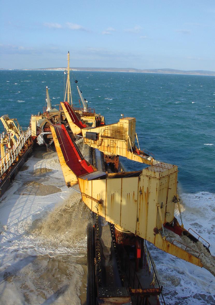
23 23

24 The Crown Estate 1 St James s Market London SW1Y 4AH T E enquiries@thecrownestate.co.uk W British Marine Aggregate Producers Association Gillingham House Gillingham Street London SW1V 1HU T E bmapa@mineralproducts.org W Printed on paper from well-managed forests, controlled sources and recycled wood or fibre. FSC accredited: TT-COC
July
 July 2010 www.agg-net.com 13 for the Marin A Sea Change T he UK marine area covers some 867,000km 2, an area equivalent to some three-and-a-half times the UK s terrestrial extent. Yet, unlike on land,
28 December 2010
 A Sea Change for the Mari T he UK marine area covers some 867,000km 2, an area equivalent to some three-and-a-half times the UK s terrestrial extent. Yet, unlike on land, until now the marine environment
Sand extraction Maasvlakte 2 Project: License, Environmental Impact Assessment and Monitoring.
 Sand extraction Maasvlakte 2 Project: License, Environmental Impact Assessment and Monitoring. Ad Stolk and Chris Dijkshoorn Ministry of Transport, Public Works and Water Management Rijkswaterstaat North
Mills et al (2003) determined that aggregate extraction activities in Areas
 determined that aggregate extraction activities in Areas") Part 1 Section 4: Collated Data Analysis and Results 4.1 Herring Spawning Potential Assessment Overview The ECA Regional Monitoring Blueprint v0.3 specifies a commitment to collate and assess data related
Part 1 Section 4: Collated Data Analysis and Results 4.1 Herring Spawning Potential Assessment Overview The ECA Regional Monitoring Blueprint v0.3 specifies a commitment to collate and assess data related
Aggregates. from the sea. drawing strength from the depths
 Aggregates from the sea drawing strength from the depths Key facts Marine aggregates contribute * 17 per cent of the sand and gravel needs of England and Wales *1 * Over 40 per cent of the sand and gravel
Welsh Assembly Government Consultation Document Secondary legislation under the Marine & Coastal Access Act 2009: Part 4 Marine Licensing
 Marine Consents Unit Welsh Assembly Government Cathays Park Cardiff CF10 3NQ mcu@wales.gsi.gov.uk 29 th November 2010 Dear Sir/Madam Welsh Assembly Government Consultation Document Secondary legislation
Planning for Dredging and the Environment on the Tidal Thames
 Planning for Dredging and the Environment on the Tidal Thames 1 INTRODUCTION This Information Note forms the final document in a set of three notes designed to inform berth operators and environmental
Appendix 8: Best Practicable Environmental Option (BPEO) Assessment
 Assessment") Appendix 8: Best Practicable Environmental Option (BPEO) Assessment ABERDEEN HARBOUR EXPANSION PROJECT BEST PRACTICABLE ENVIRONMENTAL OPTION (BPEO) ASSESSMENT October 2015 Updated April 2016 TABLE OF CONTENTS
Appendix 8: Best Practicable Environmental Option (BPEO) Assessment ABERDEEN HARBOUR EXPANSION PROJECT BEST PRACTICABLE ENVIRONMENTAL OPTION (BPEO) ASSESSMENT October 2015 Updated April 2016 TABLE OF CONTENTS
Integrated Coastal Zone Management
 Integrated Coastal Zone Management Steve Collins Marine Planning & Coastal Integration Team Date: 05 November 2014 Overview To cover ICZM History and context MSP Directive MPS How marine planning contributes
Poole Harbour Channel Deepening and Beneficial Use Review of Physical monitoring in Poole Bay Technical Note 1 WITHOUT PREJUDICE
 1. Introduction Poole Harbour Channel Deepening and Beneficial Use Review of Physical monitoring in Poole Bay Technical Note 1 WITHOUT PREJUDICE This technical note reviews the physical data that was collected
Norfolk Minerals and Waste Local Plan. Sustainability Appraisal Report Non-technical summary
 Norfolk Minerals and Waste Local Plan Minerals Site Specific Allocations Development Plan Document (DPD) Single Issue Silica Sand Review Sustainability Appraisal Report Non-technical summary March 2016
Berth 9 Quay Extension Environmental Statement Non-Technical Summary
 Berth 9 Quay Extension Hutchison Ports UK Ltd July 2013 Final Report 9Y0150 CONTENTS Page 1 PROJECT BACKGROUND 1 2 NEED FOR THE PROPOSED SCHEME 4 3 DESCRIPTION OF THE CONSTRUCTION PHASE 4 4 DESCRIPTION
Chapter 8 Natural Resources
 Chapter 8 Natural Resources 127-134 8.1 Introduction 8.2 Extractives Industry 8.3 Forestry 8.4 Fishing / Aquaculture 8.1 Introduction Kerry has a number of naturally occurring resources that contribute
Sectoral Marine Plan for Wave and Tidal Energy in Scotland s Renewable Energy Zone. Strategic Environmental Assessment Screening and Scoping Report
 Sectoral Marine Plan for Wave and Tidal Energy in Scotland s Renewable Energy Zone Strategic Environmental Assessment Screening and Scoping Report July 2011 CONTENTS Page 1. INTRODUCTION Background 1 Report
Prepared by the National Parks & Wildlife Service of the Department of Arts, Heritage & the Gaeltacht
 MARINE NATURA IMPACT STATEMENTS IN IRISH SPECIAL AREAS OF CONSERVATION A WORKING DOCUMENT APRIL 2012 Prepared by the National Parks & Wildlife Service of the Department of Arts, Heritage & the Gaeltacht
Water Quality in Cleveland Bay. Frequently Asked Questions
 Water Quality in Cleveland Bay Frequently Asked Questions 1 NATURAL WATER QUALITY IN CLEVELAND BAY What is turbidity and how does it relate to water quality? Turbidity is caused by particles suspended
Hydropower Guidance Note: HGN 7 Competing Schemes
 Guidance Note Hydropower Guidance Note: HGN 7 Competing Schemes This guidance is not intended as a statement of law and should be read in combination with and in the context of the relevant enactments
Memorandum of Understanding for the Teesmouth and Cleveland Coast Special Protection Area and proposed extension
 Memorandum of Understanding for the Teesmouth and Cleveland Coast Special Protection Area and proposed extension Date 31 st October 2017 1 Contents: 1. Foreword... 3 2. Introduction... 4 2.1 Background...
Building the futuretm
 Building the futuretm MARINE AGGREGATE SOLUTIONS Marine Aggregates Aggregates from the seabed satisfy a significant and expanding proportion of the UK s requirement for these most fundamental of construction
Proposed Tidal Lagoon Development, Cardiff, South Wales
 Proposed Tidal Lagoon Development, Cardiff, South Wales Evidence Plan Framework August 2015 www.tidallagooncardiff.com Document title Evidence Plan Framework Document reference Revision number 0.4 Date
WELSH GOVERNMENT RESPONSE TO RECOMMENDATIONS FROM THE CLIMATE CHANGE, ENVIRONMENT AND RURAL AFFAIRS COMMITTEE REPORT:
 WELSH GOVERNMENT RESPONSE TO RECOMMENDATIONS FROM THE CLIMATE CHANGE, ENVIRONMENT AND RURAL AFFAIRS COMMITTEE REPORT: FEEDBACK ON THE WELSH GOVERNMENT S DRAFT WELSH NATIONAL MARINE PLAN JUNE 2018 Background
Consenting, EIA and HRA Guidance for Marine Renewable Energy Developments in Scotland
 Consenting, EIA and HRA Guidance for Marine Renewable Energy Developments in Scotland Scottish Environment LINK is the forum for Scotland's voluntary environment organisations, with over 30 member bodies
AT A GLANCE. Cairns Shipping Development Project. Revised Draft Environmental Impact Statement Fact Sheet July 2017.
 Cairns Shipping Development Project Revised Draft Environmental Impact Statement Fact Sheet July 2017 AT A GLANCE > An additional 70 cruise ships into Port of Cairns each year by 2031 > Project design
1. Marine Works (Environmental Impact Assessment) Regulations 2007 (as amended), Regulation 22 - EIA Consent Decision
 Regulations 2007 (as amended), Regulation 22 - EIA Consent Decision") 1. Marine Works (Environmental Impact Assessment) Regulations 2007 (as amended), Regulation 22 - EIA Consent Decision 1.1 Title: Marine Aggregate Extraction in Area 526 Culver Extension 1.2 Regulatory
1. Marine Works (Environmental Impact Assessment) Regulations 2007 (as amended), Regulation 22 - EIA Consent Decision 1.1 Title: Marine Aggregate Extraction in Area 526 Culver Extension 1.2 Regulatory
Background Information Document
 Environmental Impact Assessment (EIA) of the Proposed Development of Phosphate Deposits off the Coast of Namibia Background Information Document Note 1. This BID addresses the proposed activities within
xxxxxx xxxxxx VOLUME 5: FOLDER 1 Consultation Report Chapter 4. PHASE 1B: EIA scoping
 xxxxxx xxxxxx VOLUME 5: FOLDER 1 Consultation Report Chapter 4. PHASE 1B: EIA scoping www.tidallagoonswanseabay.com www.tidallagoonswanseabay.com Consultation Report Chapter 4 Tidal Lagoon Swansea Bay
Draft Structure of the Environmental Report for the Spatial Offshore Grid Plan of the German Exclusive Economic Zone (EEZ) in the Baltic Sea 2013
 in the Baltic Sea 2013") Draft Structure of the Environmental Report for the Spatial Offshore Grid Plan of the German Exclusive Economic Zone (EEZ) in the Baltic Sea 2013 1 Introduction 1.1 Legal Basis and Function of Environmental
Draft Structure of the Environmental Report for the Spatial Offshore Grid Plan of the German Exclusive Economic Zone (EEZ) in the Baltic Sea 2013 1 Introduction 1.1 Legal Basis and Function of Environmental
Monitoring the impact of onshore wind farms on birds - January 2009
 Guidance te Monitoring the impact of onshore wind farms on birds - January 2009 Introduction 1. As the number of wind farms constructed in Scotland increases the need to understand the impact that these
CHESHIRE EAST LOCAL PLAN: MINERALS AND WASTE DPD: ISSUES PAPER - APRIL 2017
 5 th June 2017 Spatial Planning Team, Cheshire East Council, Earle Street, Crewe, CW1 2BJ By email: localplan@cheshireeast.gov.uk Dear Sir/Madam CHESHIRE EAST LOCAL PLAN: MINERALS AND WASTE DPD: ISSUES
Operative Part VI Annexes 26 February Annex 1: Resource Management (Marine Pollution) Regulations 1998
 Regulations 1998") Operative Part VI Annexes 26 February 2011 PART VI ANNEXES Annex 1: Resource Management (Marine Pollution) Regulations 1998 This annex is Sections 2-15 and Schedules 3-4 of the Resource Management (Marine
Operative Part VI Annexes 26 February 2011 PART VI ANNEXES Annex 1: Resource Management (Marine Pollution) Regulations 1998 This annex is Sections 2-15 and Schedules 3-4 of the Resource Management (Marine
Known and potential impacts of deep sea mining and oil and gas exploration
 Known and potential impacts of deep sea mining and oil and gas exploration Dave Paton 1 & Simon Childerhouse 2 Blue Planet Marine 1 Canberra, Australia; 2 Nelson, New Zealand www.blueplanetmarine.com Whales
These potential changes and their implications are outlined in Annex 1.
 Guidance Note Hydropower Guidance Note: This Guidance Note has been prepared by Natural Resources Wales (NRW) to provide applicants for abstraction and impoundment licences for hydropower schemes with
Scottish MPA Project Management options LOCHS DUICH, LONG AND ALSH POSSIBLE MPA
 Scottish MPA Project Management options LOCHS DUICH, LONG AND ALSH POSSIBLE MPA This is a working draft that has been produced to support initial discussions with stakeholders about management of activities
F. Impact on the Receiving Environment
 F. Impact on the Receiving Environment Dredging is a necessity for the port to remain commercially active. However, over the past two decades the Port of Waterford has acquired numerous reports and investigations
Supporting information for the exposure draft of proposed regulations for discharge and dumping activities under the EEZ Act
 Supporting information for the exposure draft of proposed regulations for discharge and dumping activities under the EEZ Act This report may be cited as: Ministry for the Environment. 2014. Supporting
Our ref: SC August SCOPING OPINION UNDER THE MARINE WORKS (ENVIRONMENTAL IMPACT ASSESSMENT) REGULATIONS 2007 (as amended)
 REGULATIONS 2007 (as amended)") [ Sent via email ] edward.skinner@tarmac.com Nigel.Griffiths@hanson.biz Our ref: SC1807 16 August 2018 Dear Mr Skinner and Mr Griffiths, SCOPING OPINION UNDER THE MARINE WORKS (ENVIRONMENTAL IMPACT ASSESSMENT)
[ Sent via email ] edward.skinner@tarmac.com Nigel.Griffiths@hanson.biz Our ref: SC1807 16 August 2018 Dear Mr Skinner and Mr Griffiths, SCOPING OPINION UNDER THE MARINE WORKS (ENVIRONMENTAL IMPACT ASSESSMENT)
A coastal concordat for England - draft v.6
 A coastal concordat for England - draft v.6 1 Executive Summary This coastal concordat is an agreement between the Department for Environment, Food and Rural Affairs (Defra), Department for Communities
4.1.1 Best Practices for Agency Coordination
 4.1.1 Best Practices for Agency Coordination 4.1.1.1 Introduction This section describes best practices for agency coordination in the use of data and information under existing authorities, as described
7 MONITORING PLAN 7.1 INTRODUCTION
 7 MONITORING PLAN 7.1 INTRODUCTION The purpose of this chapter is to outline the key monitoring requirements identified through the EIA process to monitor the environmental and social performance of the
The overall objectives of the monitoring activities are to:
 7 MONITORING PLAN 7.1 INTRODUCTION A detailed environmental and social monitoring plan will be developed for the Jubilee Phase 1 Development project and implemented by Tullow and its contractors. This
The Environment Agency s Objectives and Contributions to Sustainable Development: Statutory Guidance
 The Environment Agency s Objectives and Contributions to Sustainable Development: Statutory Guidance by the Secretary of State for Environment, Food and Rural Affairs The Environment Agency s Objectives
terms of sections 24(2), 24(5), 24D and 44, read with section 47A(1)(b) of the
, 24(5), 24D and 44, read with section 47A(1)(b) of the") 325 National Environmental Management Act (107/1998): Amendment of the Environmental Impact Assessment Regulations Listing Notice 2 of 2014 40772 194 No. 40772 GOVERNMENT GAZETTE, 7 APRIL 2017 DEPARTMENT
325 National Environmental Management Act (107/1998): Amendment of the Environmental Impact Assessment Regulations Listing Notice 2 of 2014 40772 194 No. 40772 GOVERNMENT GAZETTE, 7 APRIL 2017 DEPARTMENT
Marine Licence: 12/45/MLv1
 Natural Resources Wales 29 Newport Road Cambria House Cardiff CF24 0TP Ffôn Tel: 0300 065 3000 Ebost email: marinelicensing@naturalresourceswales.gov.uk MARINE AND COASTAL ACCESS ACT 2009: PART 4 MARINE
Marine Renewable Energy
 Policy Marine Renewable Energy Scope of this policy 1. This policy should be read in conjunction with SWT s policy Energy and Nature Conservation (2007). It updates that policy in certain areas in response
LSI Toolbox. Heidi Roberts.
 LSI Toolbox Heidi Roberts hroberts@abpmer.co.uk Name of presentation Integration of LSI into MSP and associated SEA Practical Toolbox for Practitioners on LSI Easily applied within any admin. or governance
WORKING ALONGSIDE THE MARINE HISTORIC ENVIRONMENT AN AGGREGATE DREDGING INDUSTRY PERSPECTIVE
 WORKING ALONGSIDE THE MARINE HISTORIC ENVIRONMENT AN AGGREGATE DREDGING INDUSTRY PERSPECTIVE Russell M. 1 and Firth A. 2 Abstract: The contribution of terrestrial sand and gravel quarrying to our understanding
Who does what in NZ s offshore waters?
 Who does what in NZ s offshore waters? This guide explains how government agencies and regional councils manage oil, gas and mineral exploration and production in the waters around New Zealand. Introduction
FUTURE MANAGEMENT IN ENGLAND
 Opportunities for Inshore Fisheries and Marine Environment Association of FUTURE MANAGEMENT IN ENGLAND Association of Inshore Fisheries and Conservation Authorities FORWARD This position paper was developed
6 Risk assessment methodology
 Risk assessment methodology 6 Risk assessment methodology 6.1 Introduction INPEX has committed to a systematic risk assessment process as a means of achieving best practice in environmental management
Consultation. The Approach to Environmental Impact Assessment. Neart na Gaoithe Offshore Wind Farm Environmental Statement. 6.
 Chapter 6 The Approach to Environmental Impact Assessment 6.1 Introduction 1 Under European legislation, transposed into UK and Scottish law (see Chapter 3: Regulatory and Policy Context for further information),
Falmouth Marina Dredging - Environmental Impact Assessment
 Falmouth Marina Dredging - Environmental Impact Assessment Environmental Statement Non-Technical Summary Hyder Consulting (UK) Limited 2212959 Firecrest Court Centre Park Warrington WA1 1RG United Kingdom
Name Assessor or Approver Date
 T: +44 (0)1224 295579 F: +44 (0)1224 295524 E: ms.majorprojects@gov.scot MARINE SCOTLAND LICENSING OPERATIONS TEAM S (MS-LOT) ASSESSMENT OF THE PROJECT S IMPLICATIONS FOR A DESIGNATED NATURE CONSERVATION
IROPI: National politics v environmental decisions
 Bruce Munro National Environmental Assessment Service Environment Agency Abstract IROPI: National politics v environmental decisions As a public body responsible for flood risk management in England and
WFD-compliant dredging and Article 4(7) A practical methodology with lessons for other sectors
 A practical methodology with lessons for other sectors") WFD-compliant dredging and Article 4(7) A practical methodology with lessons for other sectors Presentation by Jan Brooke*, Environmental Consultant 13 th June 2013 Prepared with Greg Whitfield, Environment
WFD-compliant dredging and Article 4(7) A practical methodology with lessons for other sectors Presentation by Jan Brooke*, Environmental Consultant 13 th June 2013 Prepared with Greg Whitfield, Environment
UNEP Principles 1. Integration of Tourism into Overall Policy for Sustainable Development
 UNEP Principles The principles cover: 1. Integration of Tourism into Overall Policy for Sustainable Development 2. Development of Sustainable Tourism 3. Management of Tourism 4. Conditions for Success
Activity classifications under the EEZ Act:
 Activity classifications under the EEZ Act: A discussion document on the regulation of exploratory drilling, discharges of harmful substances and dumping of waste in the Exclusive Economic Zone and continental
MARINE POLLUTION DEGRADATION MITIGATION MANAGEMENT IS ESSENTIAL FOR IMPROVING MARINE ENVIRONMENT
 MARINE POLLUTION DEGRADATION MITIGATION MANAGEMENT IS ESSENTIAL FOR IMPROVING MARINE ENVIRONMENT The health of the world s oceans and marine life is degrading rapidly as a result of excess human activities.
Clifton Marsh Landfill Variation of planning permission 05/09/0376 & 06/09/0395 for the continuation of landfilling until Non Technical Summary
 Clifton Marsh Landfill Variation of planning permission 05/09/0376 & 06/09/0395 for the continuation of landfilling until 2035 Non Technical Summary SLR Consulting Limited Project Ref: 403.00079.00474
Marine Works (Environmental Impact Assessment) Regulations 2007 (as amended), Regulation 22 - EIA Consent Decision
 Regulations 2007 (as amended), Regulation 22 - EIA Consent Decision") Marine Works (Environmental Impact Assessment) Regulations 2007 (as amended), Regulation 22 - EIA Consent Decision Title: Colwyn Bay Promenade Enhancement and Coastal Defence Works Regulatory Approval:
Marine Works (Environmental Impact Assessment) Regulations 2007 (as amended), Regulation 22 - EIA Consent Decision Title: Colwyn Bay Promenade Enhancement and Coastal Defence Works Regulatory Approval:
2. Assessing the potential risk to Groundwater
 Page no: 1 of 11 1. Introduction 1.1 This document provides guidance on the protection of the water environment from cemetery developments. It is for developers and local authorities intending to expand
SECTION 28 Environment Management Strategies
 SECTION 28 Environment Management Strategies 28.0 Environmental Management Strategies 325 28.1 Introduction 325 28.2 Response to Submissions 325 28.2.1 28.2.2 28.2.3 28.2.4 28.2.5 28.2.6 28.2.7 28.2.8
Babergh & Mid Suffolk Joint Local Plan: Sustainability Appraisal. August 2017
 Babergh & Mid Suffolk Joint Local Plan: Sustainability Appraisal August 2017 Contents NON TECHNICAL SUMMARY... 1 CHAPTER 1 INTRODUCTION... 2 Table 1: Stages of SA/SEA production... 2 Table 2: Statutory
Legislative and Policy Framework
 2 Legislative and Policy Framework 2 L E G I S L A T I V E A N D P O L I C Y F R A M E W O R K 2.1 Introduction The principal statute under which the natural and physical resources of Otago s coastal marine
KEY PRINCIPLES FOR TOURISM DEVELOPMENT
 KEY PRINCIPLES FOR TOURISM DEVELOPMENT Tourism is one of the world s largest industries and one that heavily depends on the natural resource base. Attractive coastal landscapes such as sandy beaches, dune
DECISION ON MARINE DISCHARGE CONSENT APPLICATION
 DECISION ON MARINE DISCHARGE CONSENT APPLICATION Application Ref:EEZ300005 OMV New Zealand Limited Application to discharge harmful substances CI-111 and DMO86277 This page is intentionally blank MARINE
Preliminary Environmental Information Report
 Riverside Energy Park Preliminary Environmental Information Report CHAPTER: 02 PLANNING INSPECTORATE REFERENCE NUMBER: EN010093 REGULATORY AND POLICY BACKGROUND June 2018 Revision 0 Planning Act 2008 Infrastructure
Corallian Colter Offshore Exploration Well - EIA Scoping Report
 Corallian Colter Offshore Exploration Well - EIA Scoping Report Bournemouth Borough Council comments on the potential scope of the Environmental Statement and the identification of sources of information.
Marine Protected Area Network Management Action Plan for Wales
 Marine Protected Area Network Action Plan for Wales 2018 2019 1 Overview For the first time, the MPA Network Action Plan for Wales 2018-19 brings together in one place the priority network level actions
15. Coastal Defences. Executive Summary: Chapter 15. Coastal Defences
 15. Coastal Defences Executive Summary: Chapter 15. Coastal Defences The potential direct and indirect impacts that will arise from the proposed Berth 201/202 works, either through the reconstruction of
WATER RESOURCES ACT 1991 THE WALES ROD AND LINE (SALMON AND SEA TROUT) BYELAWS 2017 THE WALES NET FISHING (SALMON AND SEA TROUT) BYELAWS 2017
 BYELAWS 2017 THE WALES NET FISHING (SALMON AND SEA TROUT) BYELAWS 2017") WATER RESOURCES ACT 1991 THE WALES ROD AND LINE (SALMON AND SEA TROUT) BYELAWS 2017 THE WALES NET FISHING (SALMON AND SEA TROUT) BYELAWS 2017 DOCUMENT NRW/5 PROOF OF EVIDENCE OF RUTH JENKINS HEAD OF NATURAL
WATER RESOURCES ACT 1991 THE WALES ROD AND LINE (SALMON AND SEA TROUT) BYELAWS 2017 THE WALES NET FISHING (SALMON AND SEA TROUT) BYELAWS 2017 DOCUMENT NRW/5 PROOF OF EVIDENCE OF RUTH JENKINS HEAD OF NATURAL
PENDER HARBOUR DOCK MANAGEMENT PLAN
 PENDER HARBOUR DOCK MANAGEMENT PLAN 1.0 INTENT OF DOCK MANAGEMENT PLAN The Pender Harbour Dock Management Plan (the DMP) is an instrument of policy that provides guidance in relation to docks authorized
Climate Change Strategy Tackling Climate Change
 Fife Environmental Partnership Climate Change Strategy 2014-2020 Tackling Climate Change 1 Introduction Climate Change is going to have a dramatic impact on our future. The effects of a changing climate
Experience from the UK: Monitoring, Modelling and Uncertainty
 Experience from the UK: Monitoring, Modelling and Uncertainty Lucy Greenhill Offshore Industries Advisor Joint Nature Conservation Committee (JNCC) Symposium: Towards an Environmentally Sound Offshore
Scoping Document. for the. Strategic Environmental Assessment. for Exploration Activities. on the Southwestern Scotian Slope
 Scoping Document for the Strategic Environmental Assessment for Exploration Activities on the Southwestern Scotian Slope Canada-Nova Scotia Offshore Petroleum Board August 2011 Table of Contents 1.0 Introduction...
What precisely does it mean to say that European countries are failing to meet their legal obligation under the Marine Directive?
 Brussels, 12 December 2018 Dear EU Ministers of the Environment, Clean, healthy and abundant seas by 2020. This is what European countries committed to achieve when they adopted the Marine Strategy Framework
IEMA ES Review Criteria
 IEMA ES Review Criteria Structure of the Criteria The criteria are split into three sections and a review report is structured accordingly: Section 1 addresses all of the information contained within an
Strength from the depths
 Strength from the depths Fourth sustainable development report for the British marine aggregate industry December 2010 bmapa british marine aggregate producers association Mineral Products Association
Scoping Document. for the. Strategic Environmental Assessment. for Exploration Activities. on the Southwestern Scotian Slope
 Scoping Document for the Strategic Environmental Assessment for Exploration Activities on the Southwestern Scotian Slope Canada-Nova Scotia Offshore Petroleum Board July 2011 Table of Contents 1.0 Introduction...
5 SCOPE OF THE ENVIRONMENTAL IMPACT ASSESSMENT. The scope of the EIA falls under three broad categories:
 5 SCOPE OF THE ENVIRONMENTAL IMPACT ASSESSMENT 5.1 INTRODUCTION The scope of the EIA falls under three broad categories: technical scope; spatial scope; and temporal scope. The scoping process for the
PUBLIC November Dogger Bank Stakeholder Engagement Plan
 PUBLIC November 2011 Dogger Bank Stakeholder Engagement Plan Dogger Bank Stakeholder Engagement Plan PUBLIC November 2011 Dogger Bank Stakeholder Engagement Plan Document no. : Contract no. (if applicable):
A Risk Assessment Framework for Fisheries in Natura 2000 sites in Ireland. December 2013 Version 1.3
 A Risk Assessment Framework for Fisheries in Natura 2000 sites in Ireland December 2013 Version 1.3 1 Contents Introduction... 3 DPSIR Framework (Drivers, Pressures, States, Impacts, Responses)... 3 Components
Appendix X.6 Queensland Government CSG Water Management Policy
 Appendix X.6 Queensland Government CSG Water Management Policy Coal Seam Gas Water Management Policy June 2010 Tomorrow s Queensland: strong, green, smart, healthy and fair Purpose The purpose of this
Cleveland Bay Marine Water Quality (Turbidity and Available Light) Monitoring Plan
 Monitoring Plan") Cleveland Bay Marine Water Quality (Turbidity and Available Light) Monitoring Plan 1 BACKGROUND Port of Townsville Limited (PoTL) administers the Port of Townsville, a general purpose cargo port in North
Cleveland Bay Marine Water Quality (Turbidity and Available Light) Monitoring Plan 1 BACKGROUND Port of Townsville Limited (PoTL) administers the Port of Townsville, a general purpose cargo port in North
THE CURRENT CLIMATE FOR A SUSTAINABLE BLUE ECONOMY
 THE CURRENT CLIMATE FOR A SUSTAINABLE BLUE ECONOMY BLUE ECONOMY CONFERENCE: SOUTHAMPTON, UNITED KINGDOM, APRIL 14, 2015 Surv. Mrs. Angela K. Etuonovbe Chair, Commission 4 (Hydrography) International Federation
H28. Special Purpose Quarry Zone
 H28. Special Purpose Quarry Zone H28.1. Zone description Mineral resources are important to Auckland s economy and development. The Special Purpose Quarry Zone provides for significant mineral extraction
Understanding the State Planning Policy July 2017 Changes to state interest statements, policies and assessment benchmarks
 Understanding the State Planning Policy July 2017 Changes to state statements, policies and assessment benchmarks This fact sheet outlines the key policy changes to the state statements, policies and assessment
The Precautionary Principle inside and outside Marine Protected Areas. Dr Becky Hitchin Offshore Industries Advice Manager JNCC Marine Advice Aberdeen
 The Precautionary Principle inside and outside Marine Protected Areas Dr Becky Hitchin Offshore Industries Advice Manager JNCC Marine Advice Aberdeen Overview Joint Nature Conservation Committee The Precautionary
March Environmental Statement Chapter 4 Environmental Impact Assessment Process. Application Reference: 6.4
 March 2014 Environmental Statement Chapter 4 Environmental Impact Assessment Process Application Reference: 6.4 Cover photograph: Installation of turbine foundations in the North Sea F-OFL-CH-004_Issue
Welsh Assembly Government Written Response to the Sustainability Committee Report on its Inquiry into Access to Inland Water.
 Welsh Assembly Government Written Response to the Sustainability Committee Report on its Inquiry into Access to Inland Water. August 2010 The Assembly Government s approach to water related recreation
8. Risk Assessment Process
 134 Browse FLNG Development Draft Environmental Impact Statement 8. Risk Assessment Process This section provides an overview of the EIA process undertaken for the Browse FLNG Development, from identification
Strategic Environmental Assessment for a framework for the development of clean coal
 Strategic Environmental Assessment for a framework for the development of clean coal Post Adoption Statement 1 November 2009 Contents 1 Introduction 2 2 Purpose of the Post Adoption Statement 3 3 How
Offshore wind & the environment: the UK planning system. January 2012 Emma Cole
 Offshore wind & the environment: the UK planning system January 2012 Emma Cole Summary Drivers and ambitions Market and deployment The regulatory framework (More) planning reform Challenges Drivers and
THE LEGAL FRAMEWORK FOR SETTING UP A DEEP SEA PORT IN NIGERIA BY TOKUNBO ORIMOBI LP
 THE LEGAL FRAMEWORK FOR SETTING UP A DEEP SEA PORT IN NIGERIA BY TOKUNBO ORIMOBI LP In the global maritime industry, there is a trend moving towards the creation of deep seaports. Most developments in
Water Quality and Pollution
 Chapter 6 Water Quality and Pollution Guiding Principles: Chapter 4 details all the guiding principles relevant to the overall management of the Harbour. Whilst all should be given some consideration the
Chapter 6 Objective: Protect and Enhance the Environment
 Chapter 6 Objective: Protect and Enhance the Environment 49 Irish Water Water Services Strategic Plan Our Strategic Aims Ensure that Irish Water services are delivered in a sustainable manner which contributes
Scoping Document for the Environmental Assessment. BP Exploration (Canada) Ltd. Tangier 3D Seismic Survey
 Ltd. Tangier 3D Seismic Survey") Scoping Document for the Environmental Assessment BP Exploration (Canada) Ltd. Tangier 3D Seismic Survey Exploration Licenses 2431, 2432, 2433, and 2434 August 2013 Contents 1.0 Purpose... 2 2.0 Regulatory
Scoping Document for the Environmental Assessment BP Exploration (Canada) Ltd. Tangier 3D Seismic Survey Exploration Licenses 2431, 2432, 2433, and 2434 August 2013 Contents 1.0 Purpose... 2 2.0 Regulatory
UK Technical Advisory Group on the Water Framework Directive
 UK Technical Advisory Group on the Water Framework Directive Criteria and Guidance Principles for the designation of heavily modified water bodies This Guidance Paper is a working draft defined by the
Strength from the depths
 Strength from the depths Ninth sustainable development report for the British marine aggregate industry December 2015 bmapa british marine aggregate producers association Mineral Products Association Contents
Item 8: Local Plan Preferred Options
 ITEM 8: Local Plan Preferred Options Purpose of Report a. To seek approval from members of the Core Strategy and Development Management Policies Preferred Options Draft Local Plan document for public consultation.
2012 Code of Conduct for Minimising Acoustic Disturbance to Marine Mammals from Seismic Survey Operations
 2012 Code of Conduct for Minimising Acoustic Disturbance to Marine Mammals from Seismic Survey Operations The Guidelines for Minimising Acoustic Disturbance to Marine Mammals from Seismic Survey Operations