Healthy Watersheds Assessment. Potomac Watersheds in West Virginia
|
|
|
- Jerome Pitts
- 6 years ago
- Views:
Transcription
1 Healthy Watersheds Assessment Potomac Watersheds in West Virginia
2 Watershed Assessment - Goals Develop metrics to measure current condition/function & threats Rank watersheds for restoration & protection priorities Provide science-based decision support to assist partners, stakeholders & regulatory staff with management of water resources Identify data gaps & data needs
3


4 Healthy Watersheds - Methods EPA Healthy Watersheds Initiative
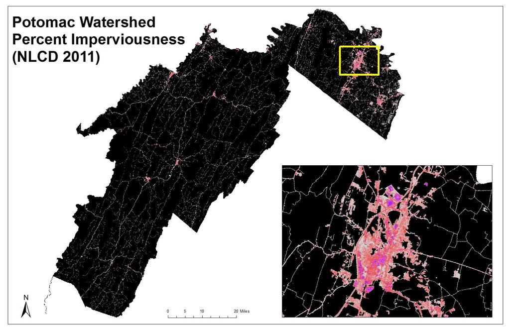
5 Landscape Condition Land use in riparian area & in entire planning unit (natural cover, agriculture, grazing, development) Mean percent imperviousness Surface mining Underground mining Timber harvesting operations Oil & gas wells Roads & railroads
6
7
8
9
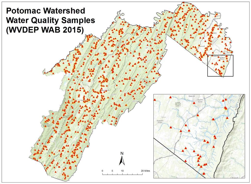
10 Water Quality Impaired Streams (303(d), TMDL) Median ph values Median specific conductivity values Median sulfate values Median GLIMPSS values (benthic macroinvertebrates) Mean percent imperviousness Surface mining Underground mining Natural cover in riparian area
11
12
13 Hydrologic Connectivity Headwater streams Wetlands Hydric soils Floodplain Floodplain forested wetlands Forested headwater wetlands Forested riparian area Local integrity Dams Roads and rail in riparian area
14
15
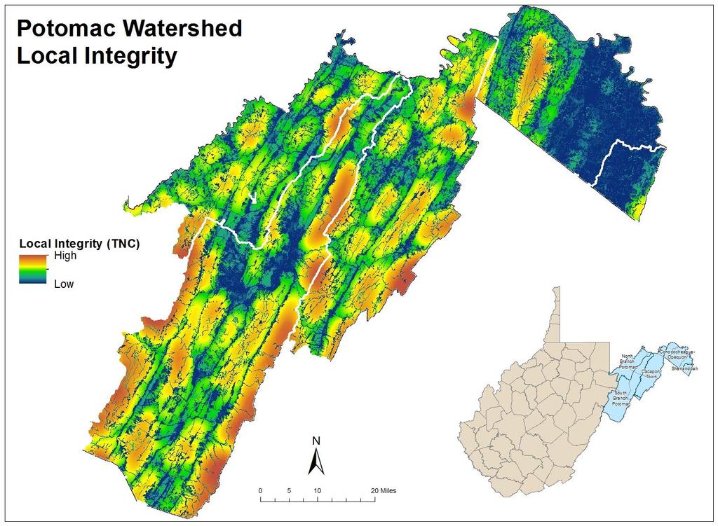
16
17 Biology/Habitat Rare species Non-native invasive species Northeast habitat types Calcareous bedrock Heterogeneity Percent tree basal area loss

18
19
20 Healthy Watersheds - Results Entire Potomac watershed in WV HUC12 & Catchment level results Objective & relative methods, both scales
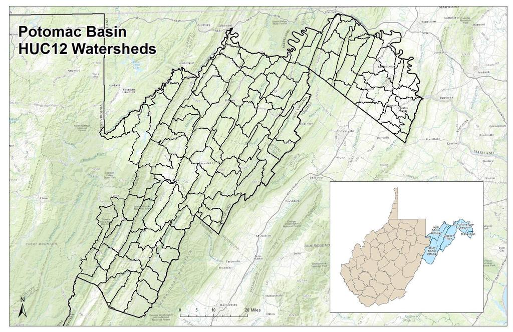
21
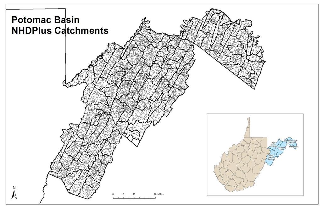
22
23 Objective Method
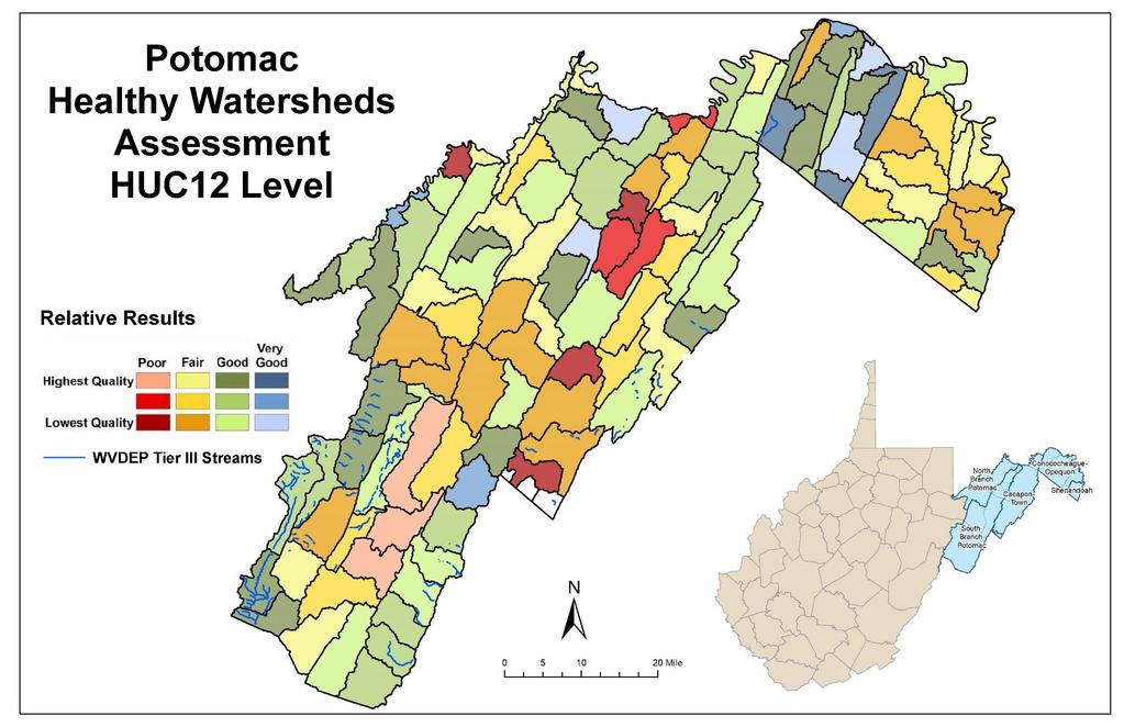
24
25
26
27
28
29
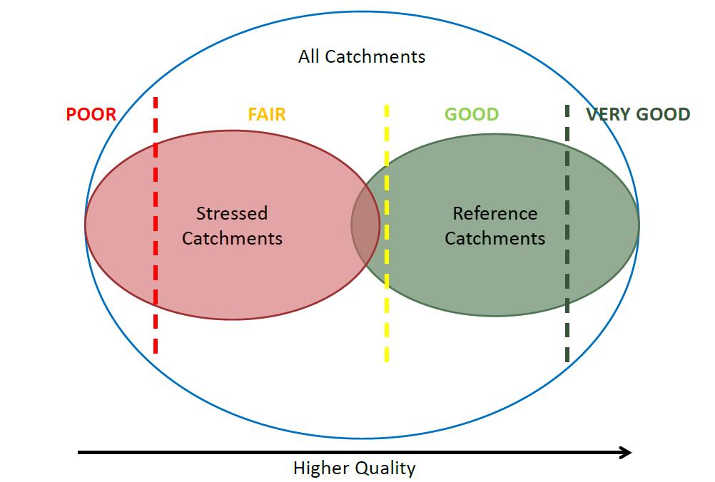
30 Healthy Watersheds - Interpret Review objective HUC12 results Compare to relative HUC12 results Identify those in Very Good or high Good categories Compare to catchment level objective and relative results; refine as needed Review metrics data to evaluate drivers Note trends and patterns Align with protection and restoration priorities
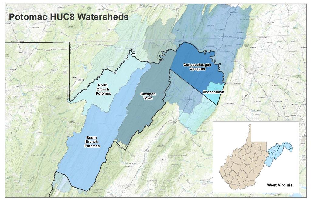
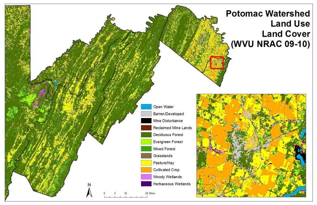
31 Objective - Good & Relative Very Good HUC8 Conococheague-Opequon Conococheague-Opequon Conococheague-Opequon Conococheague-Opequon Conococheague-Opequon Conococheague-Opequon North Branch Potomac South Branch Potomac South Branch Potomac Name Ditch Run-Potomac River Cherry Run-Potomac River Elk Branch-Back Creek Outlet Back Creek Upper Sleepy Creek Warm Springs Hollow-Back Creek Green Spring Run-North Branch Potomac River Rohrbaugh Run-South Fork South Branch Potomac River McDowell Run-South Branch Potomac River Tier I Healthiest
32 Objective - Good & Relative (high) Good HUC8 Cacapon-Town Conococheague-Opequon Conococheague-Opequon Conococheague-Opequon Conococheague-Opequon Conococheague-Opequon North Branch Potomac North Branch Potomac North Branch Potomac North Branch Potomac Shenandoah South Branch Potomac South Branch Potomac South Branch Potomac South Branch Potomac South Branch Potomac South Branch Potomac Name Capon Springs Run-Cacapon River Sir Johns Run-Potomac River Middle Sleepy Creek Lower Sleepy Creek Tilhance Creek Middle Fork Sleepy Creek Shields Run-North Branch Potomac River Mount Storm Lake-Stony River Mikes Run Keller Run-Patterson Creek Bullskin Run Big Run Zeke Run-North Fork South Branch Potomac River Jordan Run-North Fork South Branch Potomac River Stump Run-South Fork South Branch Potomac River Sawmill Run-South Branch Potomac River Laurel Fork-North Fork South Branch Potomac River Tier II Healthy

33 Catchments - Objective & Relative
34 Mostly natural cover Good water quality Good connectivity Few fragmenting features

35 Existing protected lands
36 Cacapon-Town HUC12 Objective & Relative
37 Cacapon-Town Catchment Objective & Relative

38 Cacapon-Town Land Use Land Cover
39 Healthy Watersheds - Caveats Know your priorities (e.g., preservation vs restoration) Know the data and its limitations Consider both scales carefully (HUC12 and catchment level) Be mindful of hydrologic function (e.g., pristine headwaters reaches may drain to agricultural lands, which degrade WQ) Make note of which metrics are most and least important to you (e.g., resource extraction may be of less concern in NE WV)
40 Thank you! Keith Fisher Director of Conservation Programs Misty Downing GIS Analyst
WV WATERSHED ASSESSMENT PILOT PROJECT. Gauley River Kent Mason
 WV WATERSHED ASSESSMENT PILOT PROJECT Gauley River Kent Mason Expert Workshop #2, Round 2 Capitol Conference Center, Charleston. January 8 & 9, 2013 Workshop Outline Day 1 Project Background & Methodology
West Virginia Watershed Assessment Pilot Project Outline & Assessment Methodology March 2012
 Introduction The West Virginia Watershed Assessment Pilot Project was developed to define the methodology and identify the information and tools necessary to meet the project objectives stated below. The
Workshop Day 1 October 10, 2012
 West Virginia Watershed Assessment Pilot Project Gauley, Upper Guyandotte, and Little Kanawha Watersheds First Expert Workshop Summary October 10-11, 2012 Bridgeport, West Virginia Workshop Objectives
Lake Fork of the Gunnison Watershed: Status and Stewardship. Camille Richard, Project Director
 Lake Fork of the Gunnison Watershed: Status and Stewardship Camille Richard, Project Director Upper Gunnison Basin Lake Fork Watershed 7,500 14,309 ft Sagebrush to alpine 432 square miles Population 900
Recovery Potential Screening: EPA Tools, Data and Support for Watershed Planning and Prioritizing
 Recovery Potential Screening: EPA Tools, Data and Support for Watershed Planning and Prioritizing Doug Norton Watershed Branch WRAPD/OWOW, EPA Office of Water ASWM Webinar, June 2018 1 What is Recovery
The Table of Contents
 The Tale of a Million Ditches and the 800-Pound Rodent: The surprising truth about hydrology, water quality, and habitat in the headwaters of the Great Coharie WRRI 2014 Annual Conference March 20 th,
719 Griswold, Suite 820 Detroit, MI DANVERS POND DAM REMOVAL AND STREAM RESTORATION PROJECT
 Great Lakes Restoration Initiative Grant Final Report US EPA Grant GL 00E006 43 October, 2013 Valley Woods Wetland Southfield Lola Valley Grow Zone Wayne County Parks Venoy Park Grow Zone Wayne County
CHESAPEAKE BAY COMPREHENSIVE WATER RESOURCES AND RESTORATION PLAN - UPDATE. Update to Chesapeake Bay Program STAR January 25, 2018
 CHESAPEAKE BAY COMPREHENSIVE WATER RESOURCES AND RESTORATION 255 255 255 237 237 237 0 0 0 217 217 217 163 163 163 200 200 200 PLAN - UPDATE 131 132 122 239 65 53 80 119 27 110 135 120 252 174.59 112 92
Integrating the Protection of Healthy Waters in Tribal Clean Water Act Section 319 and other Water Quality Programs
 Integrating the Protection of Healthy Waters in Tribal Clean Water Act Section 319 and other Water Quality Programs August 18, 2016 Steve Epting, US EPA Headquarters 1 Today s Talk Defining healthy watersheds
CHESAPEAKE BAY COMPREHENSIVE WATER RESOURCES AND RESTORATION PLAN. Habitat GIT Meeting 9 May 2017
 CHESAPEAKE BAY COMPREHENSIVE WATER RESOURCES AND 255 255 255 237 237 237 0 0 0 217 217 217 163 163 163 200 200 200 131 132 122 239 65 53 80 119 27 RESTORATION PLAN 110 135 120 252 174.59 112 92 56 62 102
Management Objectives and Targets
 Management Objectives and Targets As part of the Yampa River Stream Management Plan, the community of Steamboat Springs developed management objectives for the reach of the Yampa River near Steamboat Springs.
I-3 THE IMPERVIOUS COVER MODEL
 I-3 THE IMPERVIOUS COVER MODEL AT A GLANCE Imperviousness is a metric that represents the sum of roads, parking lots, sidewalks, rooftops, and other impermeable surfaces that prevents water from infiltrating
Climate Change Adaptation for Natural Resources in the North Atlantic Region
 Climate Change Adaptation for Natural Resources in the North Atlantic Region Andrew Milliken North Atlantic Landscape Conservation Coordinator U.S. Fish and Wildlife Service Preparing New Jersey for Climate
Section 319 Incremental Project Proposal for Elks Run Watershed West Virginia Stream Code:WVP-1
 1 Section 319 Incremental Project Proposal for Elks Run Watershed West Virginia Stream Code:WVP-1 in the Potomac Direct Drains Watershed Jefferson County, WV 2010 Anticipated need for 319 funding $55,000
Implementation of a Tiered Aquatic Life Use Framework for Minnesota Streams
 Implementation of a Tiered Aquatic Life Use Framework for Minnesota Streams June 13, 2012 New Text wq-ppt3-02 Minnesota Pollution Control Agency St. Paul, MN Stream Diversity in Minnesota Forest Mixed
Little Cuyahoga River
 Little Cuyahoga River Little Cuyahoga River Balanced Growth Meeting Friday, February 15, 2013 Little Cuyahoga River Watershed Plan Phase I Preliminary Report Completed October 2010 www.nefcoplanning.org
Water and Watersheds. Data Maps Action
 Water and Watersheds Data Maps Action What is the Wildlife Action Plan? Restore rare wildlife and habitats. Keep common species common. 2015 Revision: Partners in Conservation Science 2015 Revision Data
Overview of Phase II & Multiple Indicators To Assess Baseline Conditions At Conservation Projects In The Delaware River Watershed Initiative
 Overview of Phase II & Multiple Indicators To Assess Baseline Conditions At Conservation Projects In The Delaware River Watershed Initiative Stefanie A. Kroll, Ph.D., Carol Collier, Alison Minerovic, Meghan
2013 Water and Watershed Conference Plymouth State University March 22, Chris Skoglund
 New Hampshire s Watersheds at a Crossroads Coordinating a Response to Climate Change, Population Growth and Land-Use Change Using the DPSIR Model 2013 Water and Watershed Conference Plymouth State University
Headwater Wetland Restoration Techniques The Wetland Drain Restoration Project
 Headwater Wetland Restoration Techniques The Wetland Drain Restoration Project Tools for Managing Small Drainage Features in Rural Landscapes Workshop, March 5, 2014 Dave Richards, Partnership Specialist,
Overview of Tiered Aquatic Life Uses (TALU)
") www.pca.state.mn.us Overview of Tiered Aquatic Life Uses (TALU) 1. Background The Tiered Aquatic Life Uses, or TALU, framework is needed to modernize Minnesota s Class 2 water quality standards (WQS) from
www.pca.state.mn.us Overview of Tiered Aquatic Life Uses (TALU) 1. Background The Tiered Aquatic Life Uses, or TALU, framework is needed to modernize Minnesota s Class 2 water quality standards (WQS) from
Fact Sheet. Pennsylvania s Chesapeake Bay Tributary Strategy Goals for Nutrient and Sediment Reduction and Habitat Restoration
 Fact Sheet Commonwealth of Pennsylvania Department of Environmental Protection Pennsylvania s Chesapeake Bay Tributary Strategy Goals for Nutrient and Sediment Reduction and Habitat Restoration Why were
Riparian Buffer Requirements. Department of Environmental Protection Bureau of Watershed Management
 102.14 - Riparian Buffer Requirements Department of Environmental Protection Bureau of Watershed Management 102.2 Scope and Purpose BMPs to protect, maintain, and restore water quality and existing designated
Buffers improve water quality
 Buffers improve water quality Recently, the MPCA had a request asking if we could see a difference in water quality in streams from sites where there are buffers compared to sites without buffers. We looked
Appendix E : Guidelines for Riparian Buffer Areas
 Appendix E : Guidelines for Riparian Buffer Areas This document should be read in conjunction with the CRCA Planning Policy. 1.0 PURPOSE The purpose of this document is to summarize the recommendations
How Much Habitat Is Enough? How Much Disturbance is Too Much?
 How Much Habitat Is Enough? How Much Disturbance is Too Much? Jocelyn Sherwood Canadian Wildlife Service - Ontario January 27 th, 2017 Page 2 April 19, 2017 Page 3 April 19, 2017 Grasslands Forest Wetlands
How Much Habitat is Enough?
 How Much Habitat is Enough? Canadian Wildlife Service 2017 Third Edition Page 2 April 19, 2017 Grasslands Forest Wetlands Riparian & Watershed Page 3 April 19, 2017 Significant impairment in stream At
method for short and long term monitoring of Chesapeake Bay wild Mark Hudy USDA Forest Service, Fish and Aquatic Ecology Unit and
 Patch Metrics: A cost effective method for short and long term monitoring of Chesapeake Bay wild brook trout populations? Mark Hudy USDA Forest Service, Fish and Aquatic Ecology Unit and Andrew Whitely;
CHESAPEAKE BAY COMPREHENSIVE WATER RESOURCES AND RESTORATION PLAN. Update to Chesapeake Bay Program Management Board June 14, 2018
 CHESAPEAKE BAY COMPREHENSIVE WATER RESOURCES AND 255 255 255 237 237 237 0 0 0 217 217 217 163 163 163 200 200 200 131 132 122 239 65 53 80 119 27 RESTORATION PLAN 110 135 120 252 174.59 112 92 56 62 102
Healthy and Resilient Watersheds: What s in the Way? What s Possible?
 Healthy and Resilient Watersheds: What s in the Way? What s Possible? Maine Stormwater Conference November 17, 2015 Trish Garrigan, Healthy Watersheds Coordinator EPA New England Garrigan.trish@epa.gov
IMPROVING OUTCOMES FOR STREAM ALTERATION PROJECTS
 IMPROVING OUTCOMES FOR STREAM ALTERATION PROJECTS Bethany Matousek Inland Lakes and Streams Program Coordinator Wetlands, Lakes and Streams Unit DEQ Water Resources Division MatousekB@Michigan.gov 517-243-6421
INDIAN CREEK WATERSHED PLAN EXECUTIVE SUMMARY
 INDIAN CREEK WATERSHED PLAN EXECUTIVE SUMMARY The Indian Creek Watershed covers a 38 square mile area in southern Lake County, Illinois that drains 24,116 acres before discharging into the Des Plaines
Goose Creek Watershed Assessment Summary October 2003
 Goose Creek Watershed Assessment Summary October 2003 The Goose Creek Watershed The Goose Creek watershed is 385 square miles, covering nearly half of Loudoun County and one-quarter of Fauquier County
 Good Morning! Bruce Gilman Department of Environmental Conservation and Horticulture Finger Lakes Community College 3325 Marvin Sands Drive Canandaigua, New York 14424 585-785- 1255 gilmanba@flcc.edu Northern
Hello my name is Joy Loughry and I am with the groundwater technical unit of the Minnesota department of natural resources. Today I am going to talk
 Hello my name is Joy Loughry and I am with the groundwater technical unit of the Minnesota department of natural resources. Today I am going to talk about how the state of Minnesota manages its Water resources
14(h)EPA-06 City of Springfield 76 East High Street Springfield, Ohio Clark County Greening City Plaza
EPA-06 City of Springfield 76 East High Street Springfield, Ohio Clark County Greening City Plaza") 14(h)EPA-06 City of Springfield 76 East High Street Springfield, Ohio 45502 Clark County Greening City Plaza $100,000 in FY 2014 Section 319(h) Nonpoint Source grant funding is requested to install three
14(h)EPA-06 City of Springfield 76 East High Street Springfield, Ohio 45502 Clark County Greening City Plaza $100,000 in FY 2014 Section 319(h) Nonpoint Source grant funding is requested to install three
NERRS Science. Collaborative Project
 NERRS Science Collaborative Project Detecting non point nitrogen sources and transport pathways in the Great Bay watershed and engaging decision makers in the science Investigators: Dr. William H. McDowell,
Relationship to E Flows
 Relationship to E Flows Riparian Areas Influences groundwater/surface water relationships Provides filters to improve water quality Provides habitat for diverse flora and fauna Relationship to E Flows
Primer introduction to watershed management Plan Process highlight the major steps of plan development Project types look at some examples of common
 1 Primer introduction to watershed management Plan Process highlight the major steps of plan development Project types look at some examples of common projects Plan Organization how to read the plan Next
STREAM RESTORATION PURPOSE, PRACTICE, AND METHODS. By Marcus Rubenstein, CPESC
 STREAM RESTORATION PURPOSE, PRACTICE, AND METHODS By Marcus Rubenstein, CPESC WHAT IS STREAM RESTORATION? The return of a stream s lost natural functions, usually resulting from watershed alterations,
WISCONSIN S HEALTHY WATERSHEDS TOOL. Looking ahead to target protection efforts
 WISCONSIN S HEALTHY WATERSHEDS TOOL Looking ahead to target protection efforts What I ll cover What is the Healthy Watersheds Initiative? Results! Nested Maps/Scores How can we use the information? Getting
TOTAL: 5,250 acres over next 20 years 3
 Siting of Wetland Mitigation in Northeast Minnesota Issues, Concepts, and Alternatives from the Interagency Northeast Mitigation Siting Team 1 2 Projected Future Impacts TOTAL: 5,250 acres over next 20
Project Information. Pursuant to Section 404 of the Clean Water Act (33 U.S. Code 1344), notice is hereby given that
, notice is hereby given that") US ARMY Corps Of Engineers Little Rock District JOINT PUBLIC NOTICE CORPS OF ENGINEERS STATE OF ARKANSAS Application Number: 2013-00331 Date: November 4, 2013 Comments Due: December 4, 2013 TO WHOM IT
US ARMY Corps Of Engineers Little Rock District JOINT PUBLIC NOTICE CORPS OF ENGINEERS STATE OF ARKANSAS Application Number: 2013-00331 Date: November 4, 2013 Comments Due: December 4, 2013 TO WHOM IT
Lynda Hall. ASDWA Webinar Using Clean Water Act Funding For Source Water Protection January 19, 2012
 ASDWA Webinar Using Clean Water Act Funding For Source Water Protection January 19, 2012 Lynda Hall Chief, Nonpoint Source Control Branch Environmental Protection Agency Office of Wetlands, Oceans and
Grand Traverse Bay Watershed Protection Plan:
 Grand Traverse Bay Watershed Protection Plan: An Overview Sarah U Ren Program Director The Watershed Center 231-935-1514, suren@gtbay.org The Grand Traverse Bay Watershed 973 square miles Bay Volume =
ANCHORAGE, ALASKA AR No , As Amended
 Municipal Clerk's Office Amended and Approved Date: September, 0 Submitted by: Assembly Member Croft and Assembly Member Quinn-Davidson Prepared by: Assembly Counsel For reading: September, 0 ANCHORAGE,
Managing Forests for Water Supply Protection. Anne Hairston-Strang, Ph.D. Forest Hydrologist MD DNR Forest Service
 Managing Forests for Water Supply Protection Anne Hairston-Strang, Ph.D. Forest Hydrologist MD DNR Forest Service Forests: the first barrier to pollution Forests have lowest runoff greatest soil infiltration
Watershed Improvements
 Watershed Improvements Gwinnett County Georgia Association of Floodplain Managers March 14, 2013 Overview Watershed Assessment - 1998 to 2000 Watershed Protection Plan - 2000 Watershed Improvement Plans
Clean Water Act Basics: An Overview of Core Programs. Merritt Frey Habitat Program Director River Network
 Clean Water Act Basics: An Overview of Core Programs Merritt Frey Habitat Program Director 801-486-1224 mfrey@rivernetwork.org AGENDA Introduction History of Act Goals of Act Act & Jordan Resources Why
Water Quality Ecosystem Services in the Urban Environment
 Water Quality Ecosystem Services in the Urban Environment Dianna Hogan and JV Loperfido ACES 2010 December 7, 2010 U.S. Department of the Interior U.S. Geological Survey Water Quality Ecosystem Services
Oshawa Creek Watershed Management Plan EXECUTIVE SUMMARY
 Oshawa Creek Watershed Management Plan EXECUTIVE SUMMARY The Central Lake Ontario Conservation Authority (CLOCA) has recognized the need to prepare comprehensive management strategies for all of its watersheds.
Great Lakes Riparian Opportunity Assessment Methodology New York Natural Heritage Program September 25, 2015
 Great Lakes Riparian Opportunity Assessment Methodology New York Natural Heritage Program September 25, 2015 OBJECTIVES The goal of this analysis is to assemble a suite of riparian habitat quality indicators
Public Notice. US Army Corps of Engineers Fort Worth District. Applicant: Mill Branch Stream Mitigation Bank. Permit Application No.
 Public Notice US Army Corps of Engineers Fort Worth District Applicant: Mill Branch Stream Mitigation Bank Permit Application No.: Date: November 10, 2010 The purpose of this public notice is to inform
Potomac Headwaters Leaders Of Watersheds Fall 2018 Application
 Potomac Headwaters Leaders Of Watersheds Fall 2018 Application Educating future generations of environmental stewards through in classroom education and on the ground conservation practices at schools.
ENVIROTHON AQUATICS SAMPLE TEST
 ENVIROTHON AQUATICS SAMPLE TEST Habitat Assessment Perform a visual assessment (habitat assessment) of Coalburn Creek within the designated area (100 meter reach). You will be provided with the habitat
awetlands aprairie aforests ahabitat for Fish, Game & Wildlife
 Rec. H1 priority land habitats pp. 63-67 Priority areas identified in integrated mapping assessing critical land habitat and threats to habitat pp.33-63 o Mapping is scalable for use in localized areas
Biological Uplift in Stream Restoration Projects. September 20, Presentation by: Wetlands and Waterways Program
 Biological Uplift in Stream Restoration Projects September 20, 2017 Presentation by: Wetlands and Waterways Program Integrated Water Planning Program Maryland Department of the Environment Wetlands & Waterways
Impairment of the WSR Watershed
 Impairment of the WSR Watershed Referencing the West Virginia 2012 Draft Section 303(d) List prepared by the West Virginia Department of Environmental Protection (WVDEP), the Warm Springs Run 3 (identified
Vancouver Watershed Health Assessment. Burnt Bridge Creek Watershed
 Vancouver Watershed Health Assessment Burnt Bridge Creek Watershed Presentation Overview 1. Introduction 2. Study Context 3. Burnt Bridge Creek Monitoring Program and Trend Analysis 4. Watershed Health
Quantifying the Benefits of Stream Restoration
 Quantifying the Benefits of Stream Restoration 10 th Annual GAFM Technical Conference, March 2016 Jarrod Karl, Hazen and Sawyer Presentation Outline Benefits of Stream Restoration The Watershed Approach
Chesapeake Bay Watershed Agreement Final draft January 29, 2014
 Chesapeake Bay Watershed Agreement Final draft January 29, 2014 Public comment invited through March 17, 2014. Visit: www.chesapeakebay.net/watershedagreement 1 Preamble The Chesapeake Bay watershed is
Little River Watershed Restoration Project. Mark Powell, Consultant Natural Resources Management
 Little River Watershed Restoration Project Mark Powell, Consultant Natural Resources Management Lessons Learned Strong partnerships RC&D, Soil and Water, 2 counties, Albemarle Commission, Universities,
Upper Basin Landscape Inputs and Riverine Export Fluxes
 Chapter Four: Nutrients (including Sulphates and Chlorides), Riverine Export Fluxes, and River Concentration Relationships with Landscape Input Loadings Upper Basin Landscape Inputs and Riverine Export
Applied Stream Science
 Applied Stream Science Jane Archer Project Manager Louisville District Patricia A. Grace-Jarrett, Ph. D. Senior Project Manager Louisville District Jennifer C. Thomason Project Manager Louisville District
Design, Construction, & Benefits of Integrated Stream & Wetland Stormwater Restoration Projects Presented By: Underwood & Associates / Biohabitats,
 Design, Construction, & Benefits of Integrated Stream & Wetland Stormwater Restoration Projects Presented By: Underwood & Associates / Biohabitats, Inc. RELATIONSHIP BETWEEN IMPERVIOUS COVER AND SURFACE
Chapter 5 Goals and Objectives of the Watershed
 Chapter 5 Goals and Objectives of the Watershed 5.1 Goals for the Watershed 5.2 Objectives for the Watershed Goals 5.2.1 Water Quality Impairments 5.2.2 Preserving and Protecting Designated Areas 5.2.3
Support legislation that will protect the quantity of water in Lake Erie
 Specific Regional Priorities Each of Pennsylvania s major drainage basins has an array of individual characteristics that distinguish it from other regions of the state. These include diverse geographic
TAC CHARRETTE WORKBOOK Ecosystem Management and Sustainable Forestry Practices
 For Discussion Purposes TAC CHARRETTE WORKBOOK Ecosystem Management and Sustainable Forestry Practices NEW JERSEY HIGHLANDS COUNCIL March 28, 2006 1 Overview of RMP Goals and Structure NEW JERSEY HIGHLANDS
Bluff Creek One Water
 Bluff Creek One Water The Bluff Creek Watershed has no lakes within its boundaries. As the westernmost watershed within the District, land use changes from agricultural to residential have occurred relatively
A resource assessment of the Etowah Watershed
 A resource assessment of the Etowah Watershed The Upper Etowah watershed drains a region dominated by rolling Piedmont topography with interspersed forest cover, agricultural and urban land uses. With
Regional Master Plan Consistency Report 1/8/2010
 of 47 11:31 AM Regional Master Plan Consistency Report Prepared by State of New Jersey Highlands Water Protection and Planning Council 100 North Road (Route 513), Chester, NJ 07930 Telephone: (908) 879-6737
Prioritizing Local Action. Strengthening the Resilience of the Taunton River Watershed
 Prioritizing Local Action Strengthening the Resilience of the Taunton River Watershed No Really, We re Here to Help 6/12/14 Healthy and Resilient Taunton Watershed Project EPA s Healthy Watershed Program
4. Present Activities and Roles
 4. Present Activities and Roles The present missions, authorities, activities and roles of the various agencies involved with flood protection, floodplain management and flood-damage reduction are identified
GIT 4 STRATEGY 1/22/2013
 GIT 4 STRATEGY 1/22/2013 [This version edited per 1/17/2013 GIT4 conference call] Purposes of this document: 1. to present a 2013 GIT 4 strategy using the CBP s adaptive management approach, including
D Olive Watershed. Path Toward Restoration
 D Olive Watershed Path Toward Restoration Water is the most critical resource issues of our lifetime and our children s lifetime. The health of our waters is the principal measure of how we live on the
Grand Traverse Bay Watershed Protection Plan:
 Grand Traverse Bay Watershed Protection Plan: An Overview Sarah U Ren Program Director The Watershed Center 231-935-1514, suren@gtbay.org What is a Watershed? A watershed is an area of land that captures
The Total Maximum Daily Load (TMDL) Program in Illinois. Watershed Management Section Bureau of Water
 Program in Illinois. Watershed Management Section Bureau of Water") The Total Maximum Daily Load (TMDL) Program in Illinois Watershed Management Section Bureau of Water Illinois EPA TMDL Program Illinois Integrated Water Quality Report What is a TMDL The TMDL Process 11/10/2014
The Total Maximum Daily Load (TMDL) Program in Illinois Watershed Management Section Bureau of Water Illinois EPA TMDL Program Illinois Integrated Water Quality Report What is a TMDL The TMDL Process 11/10/2014
Notice No Closing Date: September 5, 2017
 Public Notice U.S. Army Corps of Engineers Pittsburgh District In Reply Refer to Notice No. below US Army Corps of Engineers, Pittsburgh District 1000 Liberty Avenue Pittsburgh, PA 15222-4186 Application
C. Staffing Needs Approximately 150 staff days TSA #3 staff time will also be utilized.
 2017 Annual Plan I. Introduction The purpose of this annual plan is to detail work items that will be completed in 2017. The annual plan will provide a tool for SWCD staff and supervisors to evaluate program
How does sediment affect fish and macroinvertebrates?
 How does sediment affect fish and macroinvertebrates? How does sediment affect fish and macroinvertebrates? Suspended sediment (TSS): breathing, vision Sediment on streambed: egg development living space
What is Urban Tree Canopy?
 The following report was prepared by University of Vermont for Cacapon Institute in support of the WV UTC A&E project. Understanding our tree canopy is an essential first step in setting urban tree canopy
April 1999 Reclaimed Stream Study 1. Executive Summary
 April 1999 Reclaimed Stream Study 1 Executive Summary This investigation, a cooperative study between FDEP s Bureau of Mine Reclamation and Bureau of Laboratories, was conducted to determine the biological
Water for Virginia Master Naturalists. What are the types What is important to know about: Functions Values Issues
 Water for Virginia Master Naturalists What are the types What is important to know about: Functions Values Issues Francis J. Reilly, Jr. http://advancedmastergardener.org/water.htm Frank@TheReillyGroup.net
CRJC Mount Ascutney Local River Subcommittee
 CRJC Mount Ascutney Local River Subcommittee Tuesday, November 15, 2016 Windsor Welcome Center 3 Railroad Ave, Windsor Vermont DRAFT MINUTES Present: John Bruno, Charlestown Cordie Merritt, Hartland Judy
Minnesota River Integrated Watershed Management Interagency Study Team Meeting Of the Modeling Focus Group
 Minnesota River Integrated Watershed Management Interagency Study Team Meeting Of the Modeling Focus Group 28 September, 2010 University of Minnesota St. Paul, MN EXECUTIVE SUMMARY 1 SECTION I EXECUTIVE
Santa Ana River Watershed. SAWPA Celeste Cantú April 17, 2012
 Santa Ana River Watershed SAWPA Celeste Cantú April 17, 2012 What is SAWPA? SAWPA Member Agencies & Other Stakeholders Other Stakeholders 97 Water-related Agencies 4 Counties 59 Cities State water, environmental,
Middle Potomac River Watershed Assessment: Potomac River Sustainable Flow and Water Resources Analysis
 Middle Potomac River Watershed Assessment: Potomac River Sustainable Flow and Water Resources Analysis April 2014 : Potomac River Sustainable Flow and Water Resources Analysis United States Army Corps
Climate Change: Impacts, Monitoring, and Solutions
 Climate Change: Impacts, Monitoring, and Solutions 1 Responding to Climate Change 1. Projections/Impacts 2. Adaptation and Resiliency 3. Monitoring 4. What about emissions? 2 Native trout and salmon are
Unify efforts to address water resources for the Big Sky area and surrounding zone of influence in three co-equal water resources focus areas:
 EXECUTIVE SUMMARY The Big Sky Sustainable Water Solutions Forum (Water Forum) is a community-based, collaborative approach building a unified vision for future Big Sky water resources management to maintain
Regional Watershed Planning. Calumet Summit 2010: A Call to Connect Calumet Conference Center April 27, 2010
 Regional Watershed Planning Calumet Summit 2010: A Call to Connect Calumet Conference Center April 27, 2010 Basins The Calumet Region Watershed Communities Land Cover- 2006 Impervious Cover 303d Listed
SOCIO-ECOLOGICAL RESEARCH TOPICS FOR THE BLUE MOUNTAINS
 SOCIO-ECOLOGICAL RESEARCH TOPICS FOR THE BLUE MOUNTAINS Stakeholder Forum to Identify Research Topics and Specific Questions and Issues of High Priority for Natural Resource Management Topics 1. Rural
Watershed Management in Alberta Green Area
 Watershed Management in Alberta Green Area John Diiwu Alberta Outline What is the green area? Key land use activities Need for watershed management Some provincial policies Need for information and tools
Stream Health. Stream Bugs Our Stream Health Communicators. Upper Nottawasaga River Stream Health. NVCA Science & Stewardship
 NVCA Science & Stewardship Stream Health Upper Nottawasaga River, 2015 Stream Bugs Our Stream Health Communicators Stream bugs (benthic macroinvertebrates) are organisms that spend much or all of their
Flow-Based Surrogate TMDLs, A Case Study in Ohio
 Lower Grand River TMDL January 2012 This fact sheet describes the characteristics of a good surrogate total maximum daily load (TMDL) and the factors that should be considered when selecting a surrogate
Hydrologic Regime; Past and Present and Water Quality Implications
 Hydrologic Regime; Past and Present and Water Quality Implications Waseca County Water Plan Meeting Waseca County Courthouse Annex November 16, 2016 Dan Girolamo, Area Hydrologist, Waterville, MN Topics
The Chollas Creek Watershed Master Plan
 The Chollas Creek Watershed Master Plan FMA Luncheon March 13, 2017 City of San Diego Rick Engineering Company Tetra Tech HELIX Environmental Planning Key Drivers and Considerations Drivers Considerations
Request for Proposals Surface Water Improvement Fund Grants CUYAHOGA COUNTY ONLY 12/01/09
 STREET ADDRESS: Lazarus Government Center 50 W. Town St., Suite 700 Columbus, Ohio 43215 State of Ohio Environmental Protection Agency TELE: (614) 644-3020 FAX: (614) 644-3184 www.epa.ohio.gov Request
2011 Report. The purpose of this report is to briefly discuss items that were completed in 2011.
 2011 Report Narrative of the year s activities 1. Introduction The mission of the South St. Louis Soil and Water Conservation District is to provide technical, educational, and financial resources to land
Project Activity Description Water Plan Category Primary Activity Resource of Concern Priority. known)
") Board of Water and Soil s Water of Concern Targeting Projects and Activities (A) (B) (C) (D) (E) (F) (G) (H) (I) (J) (K) Conventional Subwatershed: 12- Water Quality Water Quality Scale of Activity Watershed:
Board of Water and Soil s Water of Concern Targeting Projects and Activities (A) (B) (C) (D) (E) (F) (G) (H) (I) (J) (K) Conventional Subwatershed: 12- Water Quality Water Quality Scale of Activity Watershed:
River Restoration in Iowa is there anything fishy going on here? or Fish Habitat in Iowa
 River Restoration in Iowa is there anything fishy going on here? or Fish Habitat in Iowa Jeff Kopaska Iowa Water Conference Ames, IA March 22, 2018 Where did we start? Lea, 1836 In every part of this whole